Applicant's guide for Higher Tier agreements starting on 1 January 2024
Updated 5 August 2024
Applies to England

© Crown copyright 2024
This publication is licensed under the terms of the Open Government Licence v3.0 except where otherwise stated. To view this licence, visit nationalarchives.gov.uk/doc/open-government-licence/version/3 or write to the Information Policy Team, The National Archives, Kew, London TW9 4DU, or email: psi@nationalarchives.gov.uk.
Where we have identified any third party copyright information you will need to obtain permission from the copyright holders concerned.
This publication is available at https://www.gov.uk/government/publications/higher-tier-grants-2023-countryside-stewardship/applicants-guide-higher-tier-grants-2023
1. Important dates and scheme changes
Applications for agreements starting on 1 January 2024 are closed.
1.1 Scheme changes for 2024
The agreement duration for capital items has increased. For agreements starting from 1 January 2024, you now have 3 years to complete the capital works within your Higher Tier agreement.
Land in a Site of Special Scientific Interest (SSSI) or Scheduled Monument is now eligible for capital items if the land is also managed in a Countryside Stewardship (CS) Higher Tier or an Environmental Stewardship (ES) agreement and the proposed activity has consent from Natural England.
It is now easier to find management options and capital items which can improve biodiversity by filtering to ‘Biodiversity’ under Land Use on the grant finder. Annex 2d has a list of options and items which specifically help increase biodiversity available in Higher Tier.
A new capital item ‘FY3 Squirrel control and maintenance’ has been introduced which is compatible with the supplement ‘WS3 Squirrel control and management’.
The fencing specifications for FG1, FG2 and FG3 have been updated. In addition, alternative fence posts material is now allowed for FG9. Changes will apply to agreements starting from 1 January 2024.
We are applying more proportionate reductions where claims are received late. For multi-year revenue and capital claims, the reduction will be scaled according to how late the claim is.
Soil and water and natural flood management multi-year options and capital items are now available across England, though consent still needs to be obtained.
1.2 Important dates
7 February: Start of CS 2023 application period for agreements that will start on 1 January 2024.
Before 28 April: If woodland is included in CS application, Woodland Management Plan (WMP) must be approved or approved in principle before Higher Tier initial application is submitted.
28 April (midnight): Deadline for submitting Higher Tier 2023 initial application.
By early June: Customer notified of success or failure of their Higher Tier 2023 initial application.
June to August: Higher Tier 2023 final application development with customer.
31 August: All necessary consents, permissions and evidence must be arranged by this date. WMPs, where needed for mixed applications, must be fully approved with any associated felling licence in place by this date.
31 August: WMPs, where needed for woodland only applications, must be fully approved with any associated felling licence in place by this date.
30 September: Deadline for RPA to receive any requested Baseline Evaluation of Higher Tier Agreement (BEHTA) evidence.
30 September: Deadline for RPA to receive any changes to the Higher Tier woodland only 2023 final application.
2. About Higher Tier
Higher Tier:
- offers grant payments to support our most environmentally significant sites including commons and woodlands
- allows you access to a greater range of CS grants than Mid Tier
- offers some flexibility to tailor requirements to suit your local environment
Grants are available as:
- management options – multi-year grants, most options last for 5 years, but some options can last for 10 or 20 years
- capital items – a range of grants for specific capital works or items – work must be completed within 3 years
2.1 How applications are assessed
Higher Tier is competitive so your application will be scored and ranked.
If your initial application is successful, Natural England or the Forestry Commission (or both depending on your options) will help you develop it into a final application by providing recommendations.
If your final application is successful, we will offer you an agreement. If you accept the agreement offer, your CS Agreement will start on 1 January 2024.
The payment you receive will depend on the grants you choose and compliance with your agreement.
More details can be found in annex 3.
2.2 What grants are available
There are grants available to support habitat creation, restoration, and on-going management of:
- species rich grasslands, wet grassland and water meadows
- heathland and moorland
- coastal sand dunes, vegetated shingle, saltmarsh, inter-tidal and saline habitats
- fens, reedbeds, ponds and ditches
- wood pastures and parklands, orchards, hedges and scrub
- woodland
Higher Tier also gives you access to a wider range of grants to:
- protect vulnerable or threatened species
- manage hedgerows, drystone walls, stock fencing and gates
- improve local water quality and manage flood risk in your local area
- convert and manage land to organic certification standards
- protect and enhance historic, archaeological and geodiversity features
- support educational access
- improve air quality and reduce ammonia emissions
2.2.1 Organic management and conversion options
You can apply for organic management and conversion options in combination with other grants.
We do not score the organic management and conversion options within your application. Read section 5.4.3 for further information on applications that include organic options.
You should apply for Mid Tier if you want to choose organic-only options.
2.2.2 Choose a Wild Pollinator and Farm Wildlife Package (WPFWP)
You may be able to improve your application’s score by choosing WPFWP. This package groups management options together. This will help you to provide farmland wildlife with the essential resources they need to thrive and breed successfully.
If you meet the minimum criteria for the package, your score will automatically increase. You can find full details in annex 4.
3. Who can apply and what land is eligible
You must read and meet the requirements detailed in this section as these are mandatory for all Higher Tier Agreement Holders.
Higher Tier is open to land managers who are either:
- a land owner or occupier
- a tenant
- a landlord
- a licensor
3.1 Land that is eligible
To be eligible for Higher Tier, land parcels must be entirely within England and land must be one of:
- an agricultural area (defined as any area taken up by arable land, permanent grassland or permanent crops)
- common land or shared grazing land (eligible for a 10-year agreement – read section 3.12 for more information and requirements)
- a protected site (see definition below)
- woodland (see definition below)
Protected sites include:
- SSSIs – read Find protected areas of countryside
- Special Areas of Conservation (SACs), including proposed SACs
- Special Protection Areas (SPAs), including proposed SPAs
- Ramsar sites – read the Ramsar Convention
- a terrestrial priority habitat – read UK Biodiversity Action Plan Priority Habitats
- land that supports a priority species – read UK Biodiversity Action Plan Priority Species
Land parcels already included in another CS or ES Higher Level Stewardship agreement may also be eligible for CS Higher Tier, provided:
- the same action is not being funded twice
- the options and items are compatible with each other
- the rules set out in section 3.13 are followed
Woodland is defined as an area of land that:
- is at least 0.5 hectares (ha)
- has an average width of at least 20 metres (m)
- is under groups or lines of trees that are, or will reach, at least 5m in height and with a crown cover of more than 20% of the ground area
Land that meets this definition of woodland must also meet requirements for open space. Open space in the woodland should:
- be no more than 20% of the total woodland area – this may be increased to 30% in exceptional, fully justified cases
- be no more than 0.5ha for any individual space – larger open areas will only be considered as woodland in exceptional circumstances
- include forest tracks, rides, wayleaves and other permanent open areas
If you have declared the land for grazing on the Basic Payment Scheme (BPS), it is not eligible for Woodland Improvement (WD2) options.
There is no minimum area that you must enter into the scheme, although there are minimum areas for individual options and capital items. Check the grant finder for the minimum area requirements for individual options and capital item grants before you apply for them.
If you want to apply for a CS Higher Tier agreement on woodland, you must have a Forestry Commission approved, or approved ‘in principle’, WMP. If you do not have a WMP, you need to submit your draft WMP for approval by 31 December in the year before your Higher Tier initial application is submitted. You must make sure that any relevant tree felling consents are also in place for your WMP to be approved. Read annex 5 for WMP information including deadlines.
3.2 Land that is not eligible
You cannot enter developed land and hard standing, including permanent caravan sites and areas used for permanent storage into Higher Tier, unless it is:
- a traditional farm or forestry building that is eligible for grants under CS
- a yard, track or farm building proposed for management through CS capital items
You cannot enter any of the following land into Higher Tier:
- land parcels that have solar panels for generating electricity for use off-farm – read section 3.9
- areas (1ha or more) of permanent standing or running water
- land entered into the Nutrient Mitigation Scheme (NMS)
- land that is already subject to another obligation that is incompatible with CS
- land where you do not have management control for the period of the agreement, and you are not able to have your application countersigned by the landowner – read Section 3.11
- land within the High Speed Two (HS2) route safeguarding zone
- land you have declared for grazing under the BPS into the woodland improvement option (WD2)
3.3 Applications from land managers operating multiple farm businesses
You can submit more than one application for a CS agreement in the same year.
You can include the same land parcel in more than one CS agreement provided:
- the same action is not being funded twice on the same land
- the options or items are compatible with each other
- the rules set out in section are followed
Each application will be scored separately on its own merit.
If you intend to submit more than one application in any application round, you must contact us.
3.4 Agreement land
Agreement land can only include land that is eligible for CS. Agreement land must include any:
- land parcel that will contain a paid management option or capital item at any time during the agreement period
- eligible land parcel that is designated as an SSSI or a Scheduled Monument whether or not there are paid management options or capital items associated with that land
These land parcels will become the Agreement Land and must meet the requirements set out in section 5.2 of the Higher Tier agreement holder’s guide.
If in 2021 you applied for a combined Woodland Creation and Maintenance Agreement and have met the objectives of the Woodland Creation (capital) element, provided you are eligible, you will be sent a letter asking you to confirm whether or not you want to enter into the 10 year Woodland Maintenance element of your agreement. For more details on these combined agreements refer to the Woodland Creation and Maintenance grant guidance.
If you have land previously included in an existing CS Woodland Creation Grant agreement you will be invited to apply for the multi-annual element of woodland creation – WD1. If your application is for WD1 only you do not need a WMP.
When you have submitted your last woodland creation claim, by the end of April, you will be invited to submit your application for the Woodland Creation Maintenance agreement. If successful, the agreement will start the following January and last for 10 years.
3.5 Sites of Special Scientific Interest and Scheduled Monuments
All land that is eligible for CS and contains a designated SSSI or Scheduled Monument must be included in your application. This SSSI or Scheduled Monument land must be appropriately managed and any paid management options or capital items must not cause damage.
If your land does contain an SSSI, you can apply to CS Higher Tier, Mid Tier and capital-only grants, however SSSI land is not eligible for the CS Wildlife Offers.
If your land holding contains an SSSI, whether it is in or outside of woodland, you must consult Natural England. If the SSSI is found to be in poor condition, a feasibility study (PA2) may be required. This study must be undertaken before a Higher Tier application can proceed.
If your land contains a Scheduled Monument but not an SSSI, you can apply for Higher Tier or Mid Tier including the Wildlife Offers.
Your local Natural England adviser can advise on:
- SSSI management
- whether you should apply for Mid Tier, Wildlife Offer or Higher Tier
- what you can do if there are no suitable grants available
For more information read Sites of Special Scientific Interest: managing your land
Historic England can provide free advice on Scheduled Monument management.
When you apply for CS Higher Tier:
- you must include your SSSI or Scheduled Monument land parcel or parcels – even if there are no suitable CS management options for it
- where the site is not currently in good condition, you must choose options and capital items to improve its condition, unless there are no suitable grants available – Natural England or Historic England can advise on suitable grants
- for sites already in good condition, you should choose grants to maintain the site in that condition
- where the condition of an SSSI is affected by your management of land outside the SSSI boundary, you must choose management options and capital items to support favourable condition of the SSSI
Your application will be rejected if it:
- does not include SSSIs or Scheduled Monuments on your holding
- includes any management options or capital items that could damage the SSSI or Scheduled Monument on your holding
- includes any management options or capital items that do not support the favourable condition of the SSSI or Scheduled Monument
- includes management options or capital items on the surrounding land parcels that would have a negative effect on the SSSI or Scheduled Monument
All SSSI and Scheduled Monument management needs formal consent from Natural England or Historic England as appropriate. You must apply to your local Natural England or Historic England adviser for this consent (read Section 4.10.1).
Your Natural England adviser will talk to you about your SSSI, they will consider land parcels in the application that have:
- any live SSSI consents
- Site Management Statements
- Section 15 (of the Countryside Act 1968) management agreements
- other agreements with Natural England or its founding organisations
If any of these are no longer appropriate or relevant, the adviser will ask you to consider a voluntary surrender of the consent as part of the agreement offer.
Applicants for woodland Higher Tier agreements will need to make sure their application covers appropriate SSSI and Scheduled Monument management within the woodland. Their management must be considered through the UK Forestry Standard (UKFS) WMP which is a pre-requisite for a Higher Tier application – see Create a woodland management plan.
3.6 European sites
A European site is designated as an:
- SAC, or proposed SAC
- SPA
All Ramsar sites and potential SPAs are treated as European sites under CS.
Natural England or the Forestry Commission must carry out a Habitats Regulations Assessment (HRA) if you’re planning any activity on or next to a European site.
RPA will reject your application if the HRA results show that your proposed activity will have an adverse effect on the European site.
Applications that include conservation of special features for which the European site was designated will usually be accepted. However, some multi-year options or capital items may be assessed in more detail.
3.7 Protected species
Some species are partly or fully protected by legislation. Examples of the most common protected wildlife include:
- all wild birds and their eggs and nests that are in use or being built are protected under the Wildlife and Countryside Act 1981
- European protected species (EPS) which are protected by Part 3 of the Conservation of Habitats and Species Regulations 2017
You must not disturb or damage the places that animal EPS use to rest and shelter (for example, bat roosts and otter holts). For plant EPS, you must not pick, uproot or destroy them.
To find out more about protected species see Construction near protected areas and wildlife.
If you have protected species on your land, you must consider and meet the requirements for protection which apply to those species before carrying out any management activities. For more information, see Managing wildlife on your land.
By choosing appropriate CS options, you can help to maintain suitable habitats for protected species.
3.8 Organic land
If you have land that is registered as organic or in conversion to organic status, it is eligible for CS, provided other eligibility criteria are met. The scheme provides funding for Organic Management and Conversion. Read section 5.4.3 of the agreement holder’s guide for details.
3.9 Land parcels with solar panels
Land parcels that contain solar panels for generating electricity for use off-farm are not eligible for CS.
You cannot erect solar panels on agreement land where there are management options. You can enter land with solar panels on if:
- the panels are at one end of the field
- each end of the field is registered as 2 individual land parcels
- each end is separated by a permanent boundary
For further information read the RLE1 guidance.
Solar panels powering electric fencing for livestock control or water pumping which support agreement objectives are permitted.
3.10 Integrated pest management (IPM)
Many of the CS options can contribute to IPM, enabling you to benefit wildlife by reducing the use of chemicals and pesticides whilst still achieving your yields. Read annex 7d for the options that would contribute to an IPM approach.
3.11 Management control: who can apply
To meet the requirements of management options or capital items, you must have management control of all land and activities for the entire CS agreement.
If you do not have full control of the land and all such activities, you must get the written consent of all other parties for the entire CS agreement. The next sections explain more about this. (You should also read section 3.13.1 about ‘dual use’).
3.11.1 Tenants
If you are including land in a CS application that you occupy under a tenancy, including under the Agricultural Holdings Act 1986, Agricultural Tenancies Act 1995 (a Farm Business Tenancy) or equivalent, you must have:
- management control of this land for the duration of any commitments, which may extend beyond the agreement period
- control of all the activities needed to meet the scheme requirements for the chosen CS multi-year options and capital items
- security of tenure for the full period of the CS agreement
If you have security of tenure for less than 5 years starting from 1 January 2024, you must get the countersignature of your landlord as part of your application (use the Land Ownership and Control Form). If that is not possible, that part of your land is not eligible to be included in your CS application.
You must have the agreement of your landlord or the landowner before you apply. If you are a tenant, including under the Agricultural Holdings Act 1986, Agricultural Tenancies Act 1995 (a Farm Business Tenancy) or equivalent, it is your responsibility to check that by joining CS you do not breach the terms of your tenancy.
If a landlord takes over a CS agreement from you once your tenancy has ended, they must be eligible to do so. For example, they must not be an ineligible public body.
3.11.2 Landlords
If you are a landlord, you can include land in a CS application if you can show you have let the land to a tenant, but you have management control of the land and activities on it.
As the Agreement Holder, you must give your tenant a copy of the CS agreement. You may need to provide written evidence, if requested, that you have given your tenant a copy of the agreement. It is your responsibility to make sure that your tenant does not breach the terms of the agreement. If your tenant will be using the same land to claim for the BPS, read section 3.13.1 about ‘dual use.’
3.11.3 Partnerships
If you are in a business partnership, you can apply for CS. The person submitting the application must have the appropriate permission levels in the Rural Payments service. Read section 4.1 for more information.
3.11.4 Licensors
If you are a licensor, you can apply for a CS agreement. It is your responsibility to make sure that the licensee does not breach the terms of the CS agreement.
You must make sure that the licensee is aware of the requirements of the agreement, as relevant to the licence, and include these in the licence agreement.
3.11.5 Licensees
Licensees are usually not eligible for CS as a licence arrangement will not provide sufficient management control of the land to the licensee.
If in practice your licence agreement gives you wider land management responsibilities, this may mean you are a tenant and therefore may be eligible for CS. You must show that you have sufficient management control of the land and activities to be able to apply. See section 3.11.1 for more information about CS for tenants.
3.11.6 Land owned by public bodies
Land owned or run by a public body is in general not eligible for CS. Land is not eligible if it is owned or run by:
- Crown bodies (including all government departments, executive agencies and trading funds)
- non-departmental public bodies (NDPBs)
See a list of all government departments, agencies and public bodies.
Land owned by some public bodies is eligible for CS provided the work does not form part of their obligations as a public body.
This includes land owned by:
- local authorities
- national park authorities
- public corporations
Parish councils and former college farms are not considered to be public bodies and so are eligible to apply for CS.
3.11.7 Tenants of land owned by public bodies
If you are a tenant of a public body, you will need to check with your landlord if the land is eligible for CS.
If the land is owned by an eligible public body, you will be eligible for CS, but the public body must countersign your application if you do not have security of tenure. You will not be eligible for funding any work which is already a requirement of your tenancy agreement or any other legally binding obligation.
If the land is owned by an ineligible public body, you will still be eligible for CS if you have security of tenure for the full term of the agreement, including the durability requirement, as the public body cannot countersign the application. You will not be eligible for funding any work which is already a requirement of your tenancy agreement or any other legally binding obligation.
3.12 Common land and shared grazing
Common land and shared grazing are only eligible for Higher Tier. Commoners or graziers need to agree and name one person to sign the application. This person is responsible for maintaining the relevant agreement, if accepted, on behalf of all the commoners or graziers.
Before applying, you must read this section which contains the important additional requirements relevant to a Higher Tier application that includes common land and shared grazing.
These requirements are mandatory for all Higher Tier agreement holders with applications on common land and shared grazing.
3.12.1 Definitions of common land, shared grazing and commons association
In the context of a Higher Tier application, ‘common land’ means either:
- land registered as common land in a register of common land kept under Part 1 of the Commons Act 2006
- land to which Part 1 of that Act does not apply and which is subject to rights of common within the meaning of that Act
This is taken from the definition of ‘common land’ given in schedule 5 of the Commons Act 2006.
‘Shared grazing’ means communal pasture where graziers have a legal entitlement to graze (for example, a pasture used jointly by tenants) where the land is not registered as common land.
In the term ‘commons association’ the word ‘association’ is used to cover landowners, sporting tenants and graziers working together in an association or group unless otherwise stated.
3.12.2 About your application
Common land and shared grazing agreements are only available through Higher Tier and for a term of 10 years.
Agreements can only include land that is part of the common. You must apply for any non-common land parcels as part of a separate Mid or Higher Tier application.
Agreements may consist of one or more whole or part commons, provided they form a single grazing unit.
An internal agreement must be set up and signed by all the parties to the CS application. It must list each person’s responsibilities and the payments they may expect to receive.
The parties to the CS application must appoint a representative to be the main business contact for the CS application and subsequent CS agreement. Throughout the remainder of this guide this person will be referred to as ‘the applicant or you’.
You must download copies of the Common land and shared grazing supplementary application form.
You need to fill in the form and send it with your final CS Higher Tier application unless you are the owner of the whole common and have sole use and rights to the land. If you do, then you can enter the common as your holding or include it with your holding in your own CS application.
A Natural England adviser will work with you to build a suitable application.
Organic maintenance and conversion options in CS are not available for common land or shared grazing.
We now accept applications that include land where invisible fencing is used or will be used during the period of the agreement, however we do not pay for invisible fencing.
3.12.3 Commons association or internal agreement
Setting up an effective internal agreement between applicants is a requirement of a CS agreement offer. You must have a signed copy of the agreement, including financial information, before the CS agreement can begin. You must send a signed copy of the internal agreement to us before the Higher Tier agreement’s start on 1 January 2024..
Natural England or RPA cannot be involved in drafting the document or in any dispute about its operation.
The internal agreement must be fit for purpose, fair and reflect the respective parties’ contribution to the scheme. If it is not and parties cannot agree on amendments, then we may not offer a CS agreement. During the agreement term, we may ask to see formal evidence that the internal agreement operates effectively, for example, minutes of recent meetings and distribution of funds.
A commons association must be set up if there are 5 or more parties benefiting from, or contributing, to the delivery of the CS agreement. You must keep evidence that shows that this formal commons association has been set up. We may ask to see this evidence.
If there is already an association in place, it can continue as long as it meets the minimum requirements set out in this guide. If an existing commons association covers a number of commons, a separate group of members must be set up (under the umbrella of the association) to create an internal agreement for the common that is the subject of the CS application.
3.12.4 Requirements of a commons association or internal agreement
The association must effectively represent all those who have a legal and active interest in the management of the land. These are:
- the landowner
- all active commoners or graziers
- the people who may have a legal or active interest in managing the common or shared grazing, for example the owner of shooting rights
You must consult with these representatives when preparing the CS application.
Some landowners may not wish to be involved but prefer to be represented by their agents or their tenants who are permitted to graze or utilise rights. You should always consider the landowners’ surplus in any negotiations.
The internal agreement must involve all the active rights holders.
You must also:
- consider inactive rights holders, especially those who can use their rights, as they may wish to do so during the period of the agreement
- consider that some rights-holders may lease their rights – rights of common attached to land cannot be leased for a term longer than 2 years, although the lease can be renewed at the end of each term – an RPA field officer, other inspector or auditor may ask to see evidence of any lease
- contact anyone who does not want to participate in the CS agreement or anyone who has a grievance
- consider non-participants existing management practices and proposals for changes in case they put the objectives and requirements of the internal agreement and C S application at risk. It may be possible to address their concerns and make them a party to the internal agreement and CS application. Or, as they can legally exercise their rights on the common, it may be necessary to negotiate ways to fulfil their aims without risking the internal agreement and CS application
- keep a record of any decisions so you can deal with any disputes that occur at a later date
To make sure all potential participants, landowner, sporting rights holders and graziers in the CS agreement are consulted and briefed, you can consult the potential participants in the CS agreement individually, in small groups, or at a general meeting.
A general meeting can also serve to brief individuals and organisations that have an interest in the land, for example Natural England (if the land or part of it is an SSSI), or members of the community. You can place notices in local newspapers and at access points to the common.
Where the group will have 5 or more members, you must appoint officers to manage the association – a chairman, secretary and a treasurer are essential. These must not all be from one family or enterprise (for example, they must have separate single business identifiers (SBIs)), and they must reflect the range of beneficiaries in the agreement.
The written constitution must authorise these officers and the applicant to carry out certain specified business on behalf of the association, for example to open and operate a bank account.
You must agree a formula to allocate payments to members of the association or group. This formula can make payments according to their contribution and levels of responsibility.
You must have a written constitution. Whilst any bodies or individuals providing assistance may be able to provide a draft or template constitution, you must make sure that the constitution meets the needs of the particular circumstances of the group. The constitution must:
- describe membership requirements and list the members
- list responsibilities and officers
- set out governance for decision making and meetings
- identify group commitments
- set out how the CS agreement payments will be paid
- describe how the multi-annual options and requirements for capital items will be complied (met) with on the common or shared grazing
- describe a management mechanism for decision making and the resolution of disputes
- set out how changes in membership will be dealt with
The internal agreement must make provision for increases in grazing livestock numbers by those not involved in the CS agreement.
Where there is a maximum level of stocking set in the CS agreement, you must add a clause in the internal agreement to state that the graziers already involved in the CS agreement will, if necessary, reduce their stock numbers in order for the overall level of stocking to stay within this maximum.
Negotiation of the internal agreement can provide the opportunity to agree husbandry practices that help participants work together to manage the common or shared grazing.
You must keep full records of all the meetings at which the decisions set out above were agreed.
Compliance with the CS agreement will be the shared responsibility of those who are party to the internal agreement, but day to day administration will be the particular responsibility of the applicant.
3.12.5 No known landowner
Where there is no known landowner, and ownership is recorded as unknown on the commons register, you should contact us to discuss the circumstances.
Where there is no known landowner, ownership will almost always be with the local authority.
Responsibility for management of some commons is with the local authority under a scheme for the regulation and management of a common made under the Commons Act 1899, including in some cases where the common has no known owner. In these cases, you will need agreement for your application from the local authority.
Where the landowner cannot be identified or contacted, you will need to give us a full explanation for the application to progress.
3.12.6 Part-commons
Part-common agreements are only allowed under exceptional circumstances, on a case-by-case basis, as agreed with us.
Normally commons coincide with habitat and management boundaries, but exceptionally parts of a single common may be managed in different ways. In such circumstances, it may be more appropriate to progress applications representing ‘part-commons’.
Part-commons agreements must satisfy all the requirements for commons agreements:
- they must cover a defined area of land with its own Rural Payments service land parcel number(s)
- the agreement area must either be visibly distinct or be bounded by a physical barrier to mark it out from the non-agreement area
- they must be subject to a separate and binding association and group internal agreement
In addition, part-commons agreements must also:
- be managed as a separate and single grazing unit, where land management practices on the remaining part of the common will not put delivery of the agreement at risk.
- have an audit trail justifying splitting the common, and a clear explanation as to how the CS agreement works that also covers any non-participation by any rights holders
Areas of common cannot be left out of a CS agreement to create ‘sacrifice places’ for unsuitable supplementary feeding, or to provide grazing areas for non-signing commoners which may then not be compliant with the CS agreement whilst the rest of the common is compliant.
We keep a central register of all part-common agreements.
3.12.7 Before making an application
To apply for Higher Tier on common land or shared grazing, you must follow each step.
Step 1: Consult stakeholders
Before you can apply, you need to make sure all interested parties are aware of the application and that reasonable attempts have been made to help them understand and agree to the application. Interested parties include:
- landowners
- common right-holders
- other stakeholders
You’ll need to consult with these groups if the common land is subject to an agri-environment agreement for the first time.
The extent of public engagement required will depend upon the level of management change which is being considered within the CS agreement.
You can find more guidance on this in section 13.12.8.
Step 2: Select a representative or agreement signatory
Once potential applicants have read this guidance, and have decided to pursue a CS application, they will need to agree on the person who will make the application on their behalf. We need a letter of authority signed by all potential participants in the CS agreement, such as the landowner, sporting rights holders and graziers.
This person (who can be an agent) will be the main business contact for the CS application and subsequent CS agreement. This person will sign the CS agreement on behalf of the group or association, act on behalf of the association and receive the payments.
Step 3: Establish a group with a commons association or internal agreement
Establish a commons association or internal agreement, in line with the requirements set out in Steps 1 and 2. If there is already an association in place, you can continue with it, as long as it can fulfil the minimum requirements set out in this guide.
If help is needed to set up an association, this may be available from farmers’ representative bodies, a federation of commoners, commons councils, a land or agricultural agent or surveyor, or a solicitor specialising in rural practice. Associations may be able to apply for the Administration of group managed agreements supplement (SP10) to cover some of these administrative costs in establishing and managing a CS agreement where there are 2 or more parties involved.
Step 4: Open a bank account
Open a bank account on behalf of the association.
Step 5: Contact us and complete an application form
Contact RPA or Natural England, or both (where appropriate) in good time to discuss your CS application. If the common or shared grazing is in an existing agri-environment agreement, you will need to check this guide to make sure that you are able to meet the new agreement requirements.
If you are not an existing Higher Level Stewardship Agreement Holder, contact us to discuss your proposed application. The application would then follow the same timetable as any other Higher Tier application.
Potential applicants should read the Higher Tier applicant’s guide so that they can consider their options and begin discussions within their association at an early stage.
If you decide to proceed, you must submit an application form by 28 April. If the application is successful and you subsequently accept an agreement offer your CS agreement will start on 1 January 2024.
Step 6: Register a Single Business Identifier (SBI) and check Rural Payments service
There must be a separate SBI for the association (even if members of the association already have their own SBIs). The individual beneficiaries who are part of the association will also need to be registered with us in the Rural Payments service.
You should make the application to register the commoners’ or graziers’ association with us. You will need to check that the common is registered correctly in the Rural Payments service, liaising with the other participants to agree how to enter the land into a CS agreement. You must resolve any boundary issues with neighbouring commons and farms before you apply.
Step 7: Develop an application with Natural England and RPA
We will work with you and Natural England to develop the details of the proposed agreement. In doing so, we will need to see the details of the internal agreement, as this may affect the options for inclusion in the agreement.
You must fill in the Common land and shared grazing supplementary application form and send it with your final application. On this form you must be able to declare on the supplementary form that:
- the landowner of the common or shared grazing consents to the CS agreement, and
- the RPA customer registration (SBI) for the common or shared grazing includes the names and SBIs of all people who will benefit from or contribute to the delivery of the CS agreement
You must send us this final application (and accompanying documentation) by 31 August. As with any successful Higher Tier application, we will issue an agreement offer, with a declaration for you to sign and return.
You must send a signed copy of the internal agreement to us before the Higher Tier agreement starts on 1 January 2024.
Step 8: Get SSSI consent
Where the land includes an area of SSSI, the CS agreement offer will be subject to a formal notice and consent process.
If new members wish to join the association during the CS agreement period, to deliver management as part of the CS agreement, the association must refer the matter to Natural England, since the changes may need to be covered by a consent.
Anyone carrying out activities on an SSSI without consent may be acting in breach of the Wildlife and Countryside Act 1981.
3.12.8 Public engagement
The extent of public engagement required will depend upon the management change which is being considered within the CS agreement and the impacts that the changes may have on features of interest on the common and on local and national stakeholders. Almost all commons have features of public interest, these include but are not limited to:
- geodiversity features
- public access rights
- historic features
- landscape
- nature conservation
See guidance on carrying out works on common land. This sets out the type of work that requires consent from the Planning Inspectorate, exemptions and how to apply.
Where work is proposed that needs consent from the Planning Inspectorate you must follow the principles set out in Historic England guidance on community engagement for those contemplating management on common land.
Where management changes do not require consent from the Planning Inspectorate public consultation is still required. In these circumstances you do not need to follow the principles in ‘A common purpose’ but it may be helpful to do so, particularly where there is considerable public interest in your site, for example, if there are significant numbers of visitors.
You should identify relevant stakeholders, contact them, supply information about the proposed scheme, what the intended outcomes will be (for example for biodiversity), and give them the opportunity to give feedback, especially if the proposals would affect them.
It may be helpful to prepare a summary of the scheme proposals, including maps and pictures that you can send to stakeholders, posted on relevant websites and handed out at public meetings.
You should consult:
- the owners of the land
- the commons council or association (if there is one)
- others with a legal interest, for example tenants, anyone who has easements or other rights and covenants over the land
- all known commoners (whether they’re actively using their rights or not)
- any parish, district, city or county council in the same area as the land
- Natural England
- Historic England
- National Park Authority (if the area you want to work on is in a National Park)
- Area of Outstanding Natural Beauty (AONB) Conservation Board Joint Advisory Committee (if the area of land you want to work on is in an AONB)
- the Open Spaces Society
- the Local Authority Historic Environment Record (HER)
You may also need to talk to:
- Wildlife Trusts
- Local Access Forums
- Campaign to Protect Rural England
- Ramblers’ Association
- local amenity societies if there are any in the area where the land is
- anyone living on the land or on neighbouring land who could be affected by your planned works
You should hold public meetings in local venues and invite stakeholders to hear more about the proposals and comment upon them.
You should keep a record of feedback and comments received about the proposals. You should consider how concerns from stakeholders about the proposals could be addressed by alterations to the scheme and implement these if they do not significantly compromise the outcomes sought. You should be able to demonstrate how you have adapted the scheme proposals where this is appropriate.
These are some examples of changes to scheme proposals which could be made in response to feedback:
- agreement on limitation of use of existing tracks in bad weather to reduce potential damage to track surfaces so as not to inconvenience other users
- agreement to retain certain trees (for example on heathland) where these are of significance to the local community
- alteration of grazing calendar to reduce conflict with public recreation
- avoidance of operations on non-protected historic features
- provision of new or improved access points where a common is already fenced
- provision of seating at a viewpoint
- alteration of felling proposals to retain screening of buildings, roads or industry adjacent to the common
- alteration of the location of tree planting proposals to provide screening of buildings, roads or industry
- agreement to tie back gates when these are not required to secure livestock
3.13 Land receiving other funding
You cannot use a grant for activities which you are required to carry out under other legally binding obligations. This includes private contractual obligations or for which you are receiving or have received funding from other sources.
We will carry out checks to make sure that activities are not funded twice from public money.
You cannot use CS to pay for any environmental management that is already required:
- by statutory duty, as detailed in section 3.11.6
- through payment from Exchequer funds
- through grant aid from any other public body under any other grant scheme or obligation
- through any other form of legally binding obligation, including private contractual obligations for which you are receiving or have received funding from other sources
3.13.1 Relationship with the Basic Payment Scheme (BPS)
If you are using land to claim BPS, you may also enter that same land into a CS Higher Tier agreement.
Some land that is ineligible for BPS may still be eligible for CS. For example, features such as ponds, areas of scrub and woodland which are ineligible for BPS can be eligible for CS options.
You must read the latest BPS rules.
It is your responsibility to make sure you have correctly declared BPS land use codes appropriate for the CS options you’re applying for. Options will be removed from your application if they are not compatible with the declared land use or land cover.
When you include land parcels in a CS Higher Tier application that have been used to claim BPS in the same year, we will check that the CS management option applied for is compatible with the BPS land use you have declared.
It is the BPS land use declared in the year you apply that we will check for your CS Higher Tier application, even though the CS agreement start date is 1 January 2024.
When including land parcels in your CS Higher Tier application, you should note the following restrictions:
- some CS grassland options can only be located on land declared as permanent grassland on the BPS claim
- you can only locate CS arable options on land declared as temporary grassland or other arable land use on the BPS claim
- land used to grow grasses or other herbaceous forage (whether naturally or cultivated) should be declared as permanent grassland and is not eligible for arable options. This relates to land that has not been included in the crop rotation for five years or more. If the land converts from temporary grassland to permanent grassland during your agreement, the arable option will become ineligible. The exceptions to this are where arable options are intended to create or revert land to permanent grassland
You can find information on the compatible land use classes for each option using the CS grant finder.
It is possible to have more than one CS option in a single land parcel, including options which are in separate agreements. If there is no permanent boundary between the options, you do not have to split the parcel into 2 separate land parcels in the Rural Payments service.
For more information about the BPS rules or for guidance on declaring land that is in both CS and BPS read the relevant BPS rules or contact us on 03000 200 301.
Find the Rural Payments service land use codes on BPS 2023.
3.13.2 Applying for CS where someone else is claiming BPS on the same land (‘dual use’)
In certain circumstances, it is possible for a land parcel to be used by one applicant’s SBI to claim BPS and that same land parcel to also be included in a CS application submitted by someone else under their SBI. This is known as ‘dual use’.
If you are in a ‘dual use’ situation you must be able to demonstrate that you are meeting the rules and eligibility requirements of the scheme you are claiming for and you must have a written record.
If you are the CS applicant, you need to meet the CS eligibility rules, including having management control of the land included in your CS application.
The BPS applicant must show that they have the same land ‘at their disposal’ under the BPS rules (and meet BPS eligibility rules). If you have an agreement with another person, who uses the land to apply for BPS, this does not mean that person has the land at their disposal. It is the rights and responsibilities held in relation to the land, and how they operate in practice, which determine this.
An example of ‘dual use’ is where a landlord has management control of the land for CS while the tenant has the same land at their disposal to claim BPS.
If you are the CS applicant, make sure you have a written record before the BPS application deadline (this will be 15 May in 2023) that is signed and dated by both parties. This written record could be a tenancy agreement, a letter, or both, which shows:
- the rights and responsibilities you and the BPS applicant in the ‘dual use’ situation each have for the land
- you have management control of the land, and the BPS applicant has the land ‘at their disposal’
- you have given a copy of the CS Agreement Document and the terms and conditions (once you receive them) to the other party and that they must meet the terms and conditions (unless you can show that you are carrying out the required activities).
You must also make sure that the ‘dual use’ land parcels are linked to both SBIs in the digital maps in the Rural Payments service. The BPS applicant may need to transfer the land parcels to you using an electronic or paper RLE1 form. Read about how to do this in the RLE1 guidance.
You may want to get independent professional advice, especially if you previously had a verbal agreement (rather than a written agreement) with the other party
3.13.3 Lump Sum Exit Scheme
If you have been paid a lump sum under the Lump Sum Exit Scheme, you will not be eligible to enter into new CS agreements for some options, unless you first repay the lump sum. See guidance on how lump sum payments affect some Countryside Stewardship options.
If you have been paid a lump sum under the Lump Sum Exit Scheme as a partnership or limited company, and only some partners or shareholders left the business, the remaining partners and shareholders can apply to CS (or add land to existing CS agreements) without the lump sum having to be repaid.
3.13.4 Environmental Stewardship
Land parcels in an ES Higher Level Stewardship agreement are only eligible for CS Higher Tier revenue options and capital items if they are not under an HLS management option. If you choose to put a CS Higher Tier agreement on land in an HLS agreement, you must make sure that:
- there is sufficient space for all the options and items in both agreements
- the same actions are not being funded twice
- the actions required in your existing agreement and your new CS Higher Tier agreement are compatible
It is possible to end your ES agreement early without penalty if you are successful in securing a place on another land management agreement that delivers equivalent or greater environmental value. If you do not meet this condition but still want to end your ES agreement early, you will be required to repay monies previously received.
3.13.5 Existing CS Mid Tier, Wildlife Offers and Higher Tier
You can enter land parcels in an existing CS Mid Tier or Higher Tier agreement in a new CS Higher Tier agreement provided that:
- there is sufficient space in the parcel for all the options on both agreements
- the same actions are not being funded twice
- the actions required in your existing agreement and your new CS Higher Tier agreement are compatible
You can apply for a CS Higher Tier agreement on land parcels which are not in your existing CS Mid Tier, Wildlife Offer, or Higher Tier agreement provided the activities in your new agreement do not conflict with your existing agreement.
If you have included capital items in your application for your new CS Higher Tier agreement, any capital works in your existing Mid Tier or Higher Tier agreement must have been fully completed and paid for. Capital items are not available in the Wildlife Offers.
3.13.6 Existing CS capital grants
You may have a CS Higher Tier agreement alongside any of the following CS capital-only agreements:
- CS Capital Grants
- CS Higher Tier Capital Grants
- CS Protection and Infrastructure (all items)
- CS Woodland Tree Health
- CS WMP
You can apply for a CS Higher Tier agreement on the same land parcels as your existing CS capital-only agreement if:
- there is sufficient space in the parcel
- the same works are not being funded twice
- the actions required in your existing agreement and your new CS Higher Tier agreement are compatible
You can apply for a CS Higher Tier agreement on land parcels which are not in your existing CS capital-only agreement as long as the new grants do not conflict with your existing agreement.
If you have written endorsement from a Forestry Commission woodland officer or Natural England adviser, you may apply for a:
- CS Implementation Plan (PA1)
- Feasibility Study (PA2)
- WMP (PA3) or Woodland Tree Health grant agreement on the same land parcels as an existing Higher Tier agreement
- Higher Tier capital only agreement on parcels with woodland multi-year options in place
- Higher Tier woodland agreement (WD2) on parcels already in an agreement with woodland capital items
- CS Protection and Infrastructure grant on parcels already in a Higher Tier woodland multi-year option
3.13.7 Conservation Enhancement Scheme, Wildlife Enhancement Scheme or Section 15 Management agreements
If you have land that is classed as an SSSI, you may be receiving payments under Natural England’s Conservation Enhancement Scheme (CES), Wildlife Enhancement Scheme (WES) or a section 15 (S15) management agreement.
Generally, you cannot locate CS options on these land parcels. Eligibility for CS payments will depend on the specific requirements of the CES, WES or S15 agreement and are decided on a case-by-case basis.
3.13.8 English Woodland Grant Scheme (EWGS) and England Woodland Creation Offer (EWCO)
You can apply for CS options on land parcels covered by an EWGS Management Planning Grant and certain capital grants, for example, Woodland Improvement Grant (WIG) if this does not result in you being paid twice for the same items or activities and the CS options do not conflict with any ongoing EWGS requirements.
You cannot apply for CS options on land parcels covered by a multi-annual schemes while you are still receiving annual payments for them. These schemes include:
- EWGS agreement
- Farm Woodland Payment (FWP)
- EWCO
- Farm Woodland Premium Scheme (FWPS)
- Farm Woodland Scheme (FWS)
The only exception to this is where a CS Protection and Infrastructure Grant is applied for, to support EWCO or if applying for beaver protections items BC3 ( Crop protection fencing mesh and wire for permanent crops) and BC4 (Tree Guard Post and wire).
3.13.9 Sustainable Farming Incentive (SFI) Pilot
Land parcels already in an SFI pilot standards agreement are not eligible for Higher Tier. There is a separate CS Capital Grants offer for SFI pilot participants to support delivery of the pilot standards. If you are a pilot participant, please read the GOV.UK pages for more information.
3.13.10 Sustainable Farming Incentive (SFI) 2022 and 2023
Land parcels already in an SFI agreement will be eligible for a CS agreement in 2024 if:
- they meet the scheme eligibility requirements
- the CS options chosen are compatible with the existing SFI standards, so you are not paid twice for carrying out the same or similar activities on the same land, or paid for activities that are different but conflict with each other
Further details of CS and SFI compatibilities will be published in due course.
3.13.11 Landscape Recovery
If you have a Higher Tier agreement, you can also apply for a Landscape Recovery (LR) agreement. We cannot pay you under both schemes for the same activity and the actions required in the LR agreements must be compatible with your existing HT agreement. If the LR actions are not compatible with the HT agreement, we will help you to move land from a Higher Tier agreement to a LR agreement, without recoveries, where it will maintain or increase the environmental benefits. Read Landscape Recovery: how the schemes will work - GOV.UK (www.gov.uk))
3.13.12 National Lottery Heritage Fund
Some National Lottery Heritage Fund applications can be considered for CS as a source of complementary or partnership funding, but only where the CS payments are for separate works.
Where CS agreements within an area-wide project have started less than 12 months before the Heritage Fund application, the payments will be considered as complementary funding.
3.13.13 Scheduled Monuments
In some cases, you may already receive funding for Scheduled Monuments to help manage the site, area or building. This includes grants from Historic England (formerly English Heritage) under Management Agreements for Field Monuments or a Repair Grant for Heritage at Risk.
This land may also be eligible for CS provided you do not receive any other grant or funding for the same activity.
3.13.14 Fruit and Vegetables Producer Organisation Aid Scheme
Management funded under the Fruit and Vegetable Producer Organisation Aid Scheme (for example, Operation Bumble Bee) cannot also be funded under CS.
3.13.15 Inheritance Tax or Capital Gains exemptions
If you have a business (with an SBI) that is subject to an Inheritance Tax exemption agreement with HM Revenue & Customs (HMRC), it may be eligible for the Higher Tier.
CS options and capital items may be available on land designated by HMRC as conditionally exempt from Inheritance Tax or as the object of a Maintenance Fund (heritage property), depending on the specific undertakings and proposed options or capital items.
Read Inheritance Tax and Capital Gains Tax exemption guidance: Countryside Stewardship to find out whether options and capital items are always eligible, never eligible, or need to be checked to make sure that options do not overlap with the obligations of the undertakings.
You are recommended to look at the conditional exemption undertakings for your land before applying for CS so that you choose options that are most likely to succeed.
3.13.16 National Park Authority and Areas of Outstanding Natural Beauty (AONBs) grant schemes
National Park Authority or AONB grant schemes can include both annual payments for land management and capital works. Generally, you cannot combine CS with other sources of funding for the same annual land management or capital works in the same location.
However, National Park Authority and AONB grant schemes such as the Farming in Protected Landscapes programme are designed to fund management not covered by CS or other schemes, or for measures over and above the requirements of other schemes. Please contact your National Park Authority or AONB for details.
3.13.17 Other schemes or grants
CS cannot fund works that form part of these, or similar schemes or grants:
- Capital Grants under Countryside Productivity
- Growth Programme
- LEADER
- Water Environment Grant
- Woodland Carbon Fund
- HS2 Woodland Fund
- Farming Recovery Fund
- Nature for Climate Fund
- Farming Investment Fund
- other capital grants
Equipment funded from these schemes can be used to undertake the work specified within the CS scheme.
3.13.18 Land that is under another obligation such as planning permission or Section 106 requirements
CS cannot fund works that must be undertaken as a requirement of:
- any planning permission
- a Section 106 agreement or equivalent
- restoring or remediating any works undertaken illegally
3.14 Agricultural activity in woodland areas
You must not use any woodland in an agreement for any agricultural activity during the period of that agreement, unless your woodland officer has granted you permission. This will be in exceptional circumstances only. Read section 3.1 for the definition of woodland.
4. How to apply for Higher Tier
The information you need to apply for CS Higher Tier.
4.1 Check you’re registered
Before you apply for a grant you must register on the Rural Payments service, if you have not done so already.
4.1.1 Registering land parcels
You need to register all the agricultural land parcels on your holding which are 0.0100ha or larger, so they appear on your digital maps. You also need to register all the non-agricultural land parcels you intend to include in your CS application with management options or capital items. This includes any buildings and farmyards on which you want to apply for options or capital items.
For example:
- options HS1 or HS8 for maintenance of weatherproof traditional farm or forestry buildings
- any capital works in the farmyard, such as those for water and air quality improvements
The total field size of every land parcel needs to be accounted for, including how different areas of the parcel are being used for different things, using the appropriate land use codes.
You can check all the land parcels registered to your holding in your digital maps in the Rural Payments service.
From the ‘Business overview’ screen, click ‘Land’ then ‘View land’.
To view individual land parcel details, select the land parcel you need. The ‘Parcel details’ screen shows you a digital map and details of the land parcel.
If you believe the map or any of the details are incorrect, you need to request a change to your digital map.
To request changes to your land information, you must fill in an RLE1 form and send it to us by email or post. You must send your completed form straight away. This will prevent significant delays in sending an agreement offer or your application being rejected.
Read more information on how to check your digital maps.
See the Rural Payments service land use codes 2023.
4.1.2 Authorise an agent
You can authorise an agent to fill in and submit your application for you. For an agent to act for you, you must give them the appropriate permission levels in the Rural Payments service.
4.2 Choose your agreement type
There are 3 types of application in Higher Tier, you must decide which type of Higher Tier agreement to apply for.
- Woodland-only – for applications in woodland-only parcels with multi-annual options or supporting capital items, or both. If you have Scheduled Monuments within your woodland parcels these are classed as a woodland-only application.
- Agri-environment-only – for applications on farmland and habitats not including woodland creation or improvement. You can choose to apply for management options and capital items.
- Mixed – for applications in woodland, agri-environment and capital items, which include: - SSSIs within either woodland or agricultural land - Scheduled Monuments on agricultural land
Applications for woodland creation maintenance option (WD1) are being invited once the capital works in an existing woodland creation capital agreement have been completed and claimed for. For more information read annex 5.
You need to identify the high priority CS management opportunities on your land and tell us what options you’ll focus on.
4.2.1 Help with your agreement type
For general enquiries contact RPA.
Rural Payments Agency (CS)
PO Box 324
Worksop
S95 1DF
Email: ruralpayments@defra.gov.uk
Telephone: 03000 200 301
Monday to Friday, 8:30am to 5pm, except bank holidays
Find out about call charges
For technical advice on agri-environment applications, contact Natural England. You will be directed to an appropriate adviser.
Natural England
County Hall
Spetchley Road
Worcester
WR5 2NP
Email: enquiries@naturalengland.org.uk
Telephone: 0300 060 3900
March to September: Monday to Friday, 10am to 4pm, except bank holidays
October to February: Monday to Friday, 10am to 3pm, except bank holidays
Find out about call charges
A Natural England adviser can tell you whether a Higher Tier or Mid Tier application is more appropriate.
They can give advice about agri-environment applications or the agri-environment part of mixed applications.
For technical advice on woodland applications, contact the Forestry Commission.
The Forestry Commission can give advice about woodland only applications or the woodland part of mixed applications.
Read section 4.6.7 for advice on water quality issues. You must contact CSF at least 10 weeks before you intend to submit your initial application.
If you have land in a national park, you can contact the National Park Authority who may be able to help you make your application more competitive.
4.3 Consider which land to include
As a HT agreement lasts for at least 5 years you should consider what significant environmental features or issues are on your holding (which would also be declared in your WMP, a plan that is a pre-requisite for a Higher Tier application – see annex 5). You must include any SSSIs and Scheduled Monument features, where eligible, so that you get the right type of HT application (woodland only, agri-environmental only or a mixed).
4.4 Ways to apply
To apply, you must request an application pack. This includes an application form which you must email or post to us.
4.4.1 How to request an application pack
If you have 200 or more land parcels, you cannot request your pack online. Call RPA on 03000 200 301 to request the pack.
Sign into the Rural Payments service.
Click on ‘View business’, then scroll down the business overview to ‘Countryside Stewardship applications’.
On the ‘Countryside Stewardship applications’ screen, click the relevant blue button:
- ‘Request a Higher Tier Agri-Environment application pack’
- ‘Request a Higher Tier Agri-Environment with Woodland Support (mixed) application pack’
- ‘Request a Higher Tier Woodland Support application pack’
You can then use the on-screen ‘Help’ link to take you through each process step-by-step.
4.4.2 Complete your application pack
Use the how to complete your Higher Tier application by email or post guidance to help you complete the pack.
4.4.3 When to request an application pack by telephone
You should only telephone for an application pack if you:
- have no internet access
- would like to include options to common land
- have more than 200 parcels that are included into the application
Contact RPA on 03000 200 301 by 11:59pm on 28 April 2023 and allow 5 working days to receive your pack.
4.5 Complete a Farm Environment Record (FER)
You must complete an FER map for all Higher Tier agri-environment-only and mixed applications to map the location of the environmental features of interest on your holding. This will help to indicate what management may be suitable.
You need to print 2 copies of your Options (FER map). One copy to show your option choices, the other to show the environmental features on your holding. Scan both maps and save them on your computer.
You must submit your completed FER as part of your initial application.
The FER does not need to cover the whole holding but must include:
- any land parcels on which you intend to apply for CS grants
- any SSSI land or Scheduled Monuments on your holding, even if you do not intend to apply for CS grants on them
- any land parcels that are at moderate or high risk of run-off or soil erosion
If you have any land parcels at risk of run-off or soil erosion use the Runoff and soil erosion risk assessment form.
You must not damage or remove any features mapped in the FER for the duration of your agreement.
Your application pack includes information to help you create a FER.
4.6 How to choose grants (options and capital items)
You should consider the types of grants to include in your application at an early stage. This will give you time to request any advice, approvals, consents, or permissions. Read section 4.10.
For a strong initial application:
- consider how to increase your application’s score (section 4.6.1)
- choose options that address environmental priorities in your local area (section 4.6.2)
- understand the option and capital item management requirements (section 4.6.3)
- address any priorities relating to water quality (section 4.6.7), priority habitat (section 4.6.5), priority species (section 4.7.6) and to organic land (section 4.6.8) any advice received from CSF (section 4.6.7) or CS funded facilitator
- use the advice from Natural England about SSSI land (section 4.6.1)
- address any issues or management opportunities identified in your FER (section 4.5), HEFER (section 4.9.1) or Baseline Evaluation of Higher Tier Agreements Survey (BEHTA) (section 4.9.2)
- include your approved WMP, if you have one
Make sure the grants you choose are suitable for your land and that you will be able to meet the management requirements for the length of the agreement. Once the agreement has started, changes can only be made in very limited circumstances, with written permission from RPA. Read section 6 of the agreement holder’s guide.
If you have historic or archaeological features within your woodland, you should contact your local woodland officer as soon as possible so that they have time to consider your application.
If land parcels within your application overlap with a registered park or garden, you will need to complete a Feasibility Study (Parkland Management Plan) to be considered for Higher Tier maintenance or restoration. You must also get the landowner’s consent, which could take time if there are multiple landowners.
4.6.1 How your options choice affects your initial application score
Agri-environment and mixed applications
You’ll increase your initial application score if you include priority features, such as:
- priority habitats
- Land that impacts water quality
- historic environment features
- meeting the requirements of the WPFWP
- section 41 species requiring bespoke management
- species in the woodland bird assemblage
- species in the breeding wader assemblage
You’ll get a score for these features if they need management that is only available in Higher Tier. You can include features suited to Mid Tier management, but they will not contribute to your score. Your score depends on the:
- type of feature
- priority level, as described in the Statements of Priorities
- amount offered for management, or in the case of historic features, the number of land parcels they are on
You’ll get higher scores if you:
- have SSSIs – this higher score depends on the area of the SSSI
- include genetic conservation (native breeds at risk)
- include educational access
- meet the requirements of the WPFWP
- are part of a CS Facilitation Fund Group
If your initial application is successful, you will need to develop your final application. Your final application needs to match the priorities you identified in your initial application. If it does not, it will be scored but may not be successful.
Read annex 3 for more details.
Woodland-only and mixed applications
The score for the woodland, including the woodland in a mixed application, is based on the content of your application. The Forestry Commission will confirm the woodland element score for your final application.
Read annex 5 for more details.
Any area to be scored must fit into one of 4 CS objectives:
- priority habitats
- priority species
- Plantations on Ancient Woodland Sites (PAWS) restoration
- Continuous Cover Forestry (CCF) for water
All the land included in your application must be eligible under at least one of these objectives.
You can only use one objective for an area in your application so consider your whole initial application before choosing. Supplementary points will be awarded later if your land is covered by more than one objective.
There is information on how applications are scored in annex 3.
Your score will increase if:
- the area is made up of blocks within or touching a woodland bird assemblage area
- all or part of the application is located within a woodland SSSI
- all or part of the application falls within multiple priority objectives
4.6.2 Identify local priorities
Use the CS Statements of Priorities and Priority Maps to identify the priority features and issues targeted in your area. This will help you choose which grants to include in your application.
4.6.3 Find grant details
You can find more information about the grants available in Higher Tier in:
- annexes 2a, 2b and 2c of this guide – these list all of the grants available in Higher Tier, including payment rates
- annex 5 of this guide – this includes details of the Woodland Support grants available
Countryside Stewardship grant finder
The CS grant finder lists all the grants available. You can filter the list by type, land use, tier, funding, options, supplements and capital items or search for key.
On the grant finder, you will see a full description about each grant including value, eligibility requirements and any specific requirements you must follow. This includes details of the evidence and records you should keep for your options.
4.6.4 The Wild Pollinator and Farm Wildlife Package (WPFWP)
Applying for the WPFWP will help you provide a good combination of resources for wildlife on your holding. To include the WPFWP you need to choose management options that meet the requirements of the package. In Higher Tier, these must be at least 5% of the arable, temporary grass or permanent grass area in your application. Packages are available for arable farms, pastoral farms and mixed farms.
The package is suited to holdings where an expiring Higher Level Stewardship agreement has delivered good outcomes for farmland biodiversity, such as by using the Higher Level Stewardship Farmland Bird Package.
Read annex 4 for more information.
4.6.5 Actions for priority habitat
One of the main priorities for CS is to protect and improve biodiversity. The scheme offers grants to maintain, restore and create priority wildlife habitats on farmed and forested land.
You can find which CS priority habitats there are in your local area by using the information in section 4.6.2
You may be able to create new habitat on land currently under arable, intensive grassland or forestry use. Applications for this are most likely to be successful where the new habitat will:
- extend or link existing habitat to connect separate parcels of land and reduce the number of isolated parcels
- improve the condition of river, lake and wetland features affected by diffuse water pollution and/or help reduce flood risk
4.6.6 Actions for priority species
In England, CS is the main way of supporting changes in land management that are necessary to meet many of our national and international commitments to species conservation. In particular, under the:
- Conservation of Habitat and Species Regulations 2017
- government’s Biodiversity 2020 commitment to priority species
- government’s National Pollinator Strategy
Conservation of most of England’s priority species need land management partly or wholly delivered by CS (and previous schemes).
Meeting these management requirements typically involves:
- setting requirements for options that are specific to the individual case
- using the WPFWP to provide the right combination of options (read section 4.7.4 and annex 4)
- using the threatened species supplement
You can find out which CS species and habitat priorities there are in your local area using the information in section 4.6.2.
4.6.7 Addressing water and air quality issues, including run-off and soil erosion risk
You may need consent from the Environment Agency (EA), Internal Drainage Board or local authority for management that will affect any watercourses, see section 14.10.1 Work affecting water.
Some management options and capital items can be used to help improve the quality of water and air on your farm, and in your local area.
If there is run-off and soil erosion risk identified on your FER, consider whether any grants would resolve the problem and include them in your application.
You should also use the information in section 4.6.2 and annex 6 to check whether there are areas of your holding that:
- are in high, medium, or low CS water quality priority areas or
- EA have identified as an area that could benefit from Natural Flood Management measures
You may be able to get advice from Catchment Sensitive Farming (CSF) or apply for grants that are only available with CSF approval. You must contact CSF at least 10 weeks before you intend to submit your initial application. There is no guarantee that your request will be considered.
The approval to include certain options and capital items in your application does not guarantee that the option or capital item will be in any agreement offer and it does not guarantee an agreement offer.
4.6.8 Organic conversion and management
Higher Tier provides 16 options that are only available to organic farmers and land managers. These include options for conversion to organic status (OR1 – OR5) and to continue to manage existing organic land (OT1 – OT6 and OP1 – 5).
Other scheme options and items must be included in the agreement but only if they are compatible with organic status. You should apply for the Mid Tier if you want to choose organic-only options.
To apply for the Organic Management options you must be registered with an organic control body (OCB) for the full period of the agreement. If this registration is not in place for the full agreement period, we will recover all organic payments.
If you choose to apply for the organic conversion options, you must keep your organic registration from the start of your organic conversion period through to the end of the agreement.
Conversion payments will normally be paid for up to 2 years, except for permanent crops such as fruit trees where a 3-year conversion period applies. It is possible to phase conversion, but all the land must be converted before the end of your CS agreement.
To be eligible for the organic conversion options you must either have completed:
- a Conversion Plan, which must be approved and signed-off by your OCB
- a Viability Plan, for land which does not have a signed-off conversion plan at the time you apply
If you use a Viability Plan, you must get an approved and signed-off conversion plan from your OCB before claiming any conversion option payments.
You must keep all evidence of organic certification and schedules as we may ask to see them.
Organic conversion payments are not available on your land if your business has previously received any organic conversion payments under a previous scheme, such as Organic Entry Level Stewardship (OELS).
4.6.9 Agreement duration
Most Higher Tier agreements last 5 years from the agreement start date
You must complete the capital works within a Higher Tier agreement in the first 3 years of your agreement (read section 6 of the agreement holder’s guide for more information). Some capital items may have specific deadlines.
Some Higher Tier agreements last for more than 5 years.
Table 1 shows the options that last for 10 to 20 years because they take longer to establish and improve environmental conditions. Any other options in the agreement last for 5 years, after which you will be provided with the option to continue or remove these options from your agreement. Agreements on land parcels that are common land and shared grazing last for 10 years. Read section 3.12 for more details and definitions.
Table 1: Higher Tier options and agreement lengths
| Option | Option duration (years) |
|---|---|
| Creation of coastal sand dunes and vegetated shingle (CT2) | 10 |
| Creation of inter-tidal and saline habitat on arable land (CT4) | 20 |
| Creation of inter-tidal and saline habitat by non-intervention (CT5) | 20 |
| Creation of inter-tidal and saline habitat on intensive grassland (CT7) | 20 |
| Creation of wet grassland for breeding waders (GS11) | 10 |
| Creation of wet grassland for wintering waders and wildfowl (GS12) | 10 |
| Raised water level supplement (SP2) | 10 |
| Making space for water (SW12) 20 Year | 20 |
| Management of moorland (UP3) | 10 |
| Creation of reed bed (WT7) | 10 |
| Creation of fen (WT9) | 10 |
| Creation of traditional orchards (BE5) | 10 |
| Restoration towards species-rich grassland (GS7) | 10 |
| Creation of species-rich grassland (GS8) | 10 |
| Creation of grassland for target features (GS14) | 10 |
| Restoration of forestry and woodland to lowland heathland (LH2) | 10 |
| Creation of heathland from arable or improved grassland (LH3) | 10 |
| Woodland creation – maintenance payments (WD1) | 10 |
| Restoration of lowland wood pasture and parkland (WD5) | 10 |
| Creation of lowland wood pasture (WD6) | 10 |
| Restoration of upland wood pasture and parkland (WD11) | 10 |
| Creation of upland wood pasture (WD12) | 10 |
4.7 Submit your initial application
Read the information included with your application pack. This will tell you how to submit your application forms and any supporting documents.
You must complete and submit your initial application by 28 April 2023.
You can withdraw a submitted application in writing at any time before the closing date. If there is time, you can resubmit another application to replace it.
4.8 Eligibility checks on your initial application
We will check your application is eligible and pass it to Natural England or the Forestry Commission for scoring and ranking against other applications.
Not all applications will be successful. We will tell you if you are successful and tell you why if you were not. For more information, please read section 4.13.
4.9 Final application development
If your initial application is successful, you need to develop it into a final application by 31 August 2023.
Natural England and the Forestry Commission will support you to develop your final application.
Depending on your application this support could involve:
- applying the recommendations of the Historic Environment Farm Environment Record (HEFER) consultation response (read section 4.9.1.) – you may need to consult with Historic Environment organisations
- Natural England recording the current condition and extent of agri-environment features (read section 4.9.2)
- Forestry Commission assessing the proposals on the ground to make sure they meet with scheme rules and the UKFS finalising the selection of grants, to produce the agreed environmental outcomes – this may be in negotiation with Natural England, Forestry Commission or Historic England
- agreeing requirements
- getting quotes for some capital items
- consulting Natural England about any SSSIs
- getting any consents and permissions that are needed. Read section 4.10
- carrying out soil sampling and analysis, if appropriate – this must be done in time to help you make your final grant choice
- getting other evidence for your application. Read section 4.11
4.9.1 Request a Historic Environment Farm Environment Record (HEFER) on your behalf from Historic England
We will request a HEFER for you which has information about the historic environment on your land.
You’ll get an email to tell you the HEFER report is ready to download. You must follow the link in the email to download the HEFER response. This is from the HEFER portal, which includes information about the Selected Heritage Inventory for Natural England (SHINE).
If you do not have an email address, we will send the HEFER to you by post. You should use the information provided in the HEFER to help you choose appropriate options and capital items. You must add the information to your FER. If you have any Scheduled Monuments, please read section 4.9.1. to understand your next steps in relation to these.
HEFERs are valid for 3 years. If you have a HEFER that is less than 3 years old that covers all land parcels in your application, you can use this to support your application. If you are aware of any historic features discovered after the HEFER was made, discuss this with your Natural England or Forestry Commission adviser.
4.9.2 Baseline Evaluation Survey
Agri-environment-only and mixed applications need a ‘Baseline Evaluation of Higher Tier Agreements’ (BEHTA). This is not required for woodland-only applications.
The BEHTA records the condition and extent of features at the time the application is made. This provides an environmental baseline that can be used for checking the agreement in the future.
Comparison with the baseline gives a measure of progress in achieving environmental outcomes. This data can also be used to help choose appropriate grants.
Where needed, your Natural England adviser will complete the BEHTA. This usually includes a survey of the land included in your application. Where there is suitable existing baseline evidence, a full survey may not be necessary.
4.10 Get consents and permissions
You are responsible for arranging all relevant consents, permissions, exemptions, and written advice needed for your application. You will not be paid for any work undertaken without all the necessary consents and permissions being in place before you begin.
In some cases, you will not be offered an agreement if these are not in place.
You can find guidance in this section and by using the CS grant finder. Read section 4.6.3.
To make sure you submit a valid application:
- identify the consents and permissions you need as soon as you start your application – this will depend on any designations attached to your land and on the options that you choose to include in your application
- contact the relevant organisations shown in the guidance for advice and consents, where required
- provide us with the evidence needed to support your application
You may not be aware of some of the consents and permissions you need until after you have received advice or reached a certain stage in your application development. You should contact the relevant organisations as soon as you are aware of these requirements.
4.10.1 Consents
Examples of permissions and consents you may need.
Site of special scientific interest
If your Higher Tier application includes SSSI land, you will need to request any necessary SSSI consents from Natural England. You can only request SSSI consent once you receive your agreement offer. You must send a copy of the agreement offer, along with a Notice form, to Natural England. You can download the form, Notice of proposal to cause, carry out or permit an operation requiring Natural England’s consent on a SSSI.
You can email the copy of the offer and the completed notice form to Natural England at ProtectedSites@naturalengland.org.uk. If you are unable to email it then you can post it.
Natural England
County Hall
Spetchley Road
Worcester
WR5 2NP
If you do not secure consent, your application will be rejected, and your agreement offer will be withdrawn.
Natural England can also advise on management or changes needed to keep or bring the SSSI land into favourable condition through CS.
Contact Natural England as early as possible to discuss this.
Scheduled Monuments
If you have an Scheduled Monument on your holding, the HEFER will give you management recommendations from Historic England. This will include advice on how to maintain or bring the Scheduled Monument into favourable condition and protect the feature of historic interest.
Some work may need Scheduled Monument consent from Historic England. For example, soil sampling, fencing, gateways and water supplies.
If you have a Scheduled Monument, you must:
- contact Historic England for further information and to find out whether or not you need Scheduled Monument consent
- include an appropriate option in your application
If the Scheduled Monument has been classed as ‘essential’ by Historic England, you must include options to achieve the specified outcome. You must not choose options that are damaging to HEFER features.
You can get advice on whether you can do the work so that it avoids a negative effect on the Scheduled Monument. Historic England can also advise whether proposed works are acceptable in relation to:
- listed buildings
- registered parks and gardens
- registered battlefields
Protected species
You may need a wildlife licence, which you should keep for evidence, if any activities in your application may affect protected species. Read Managing wildlife on your land and section 3.7.
Work affecting water
You may need consent from the EA, Internal Drainage Board or local authority for management that will affect any watercourses. This includes work:
- to a watercourse
- within 8m of a watercourse
- within the flood or coastal plain (for example, excavation work for a pond)
You do not need consent to establish arable margins.
You do not need to provide evidence of consent or evidence that such consent is not needed with your application. If required, you will need to have consent in place before you carry out any work. You will need to submit this evidence with your payment claim.
If you need any of the following consents, you need to allow at least 2 months for them to be issued:
- land drainage consent
- discharge consent
- an abstraction licence
You will need to get consent from EA for:
- pesticide treatment
- water extraction
- storage of slurry, silage, or fuel oil
Find contact details for your local EA office.
If your land has significant erosion problems, or is causing pollution, you need to resolve this before you can be considered for an agreement. This is particularly important in sensitive river catchments.
Tree planting
You must not plant trees where they could damage areas of ecological (in-particular species rich grassland or breeding wader habitat), archaeological or historic interest (read section 4.10.1) and will need approval from CSF.
Any applications including tree planting must follow the Environmental Impact Assessment (EIA) Regulations for Forestry and you must consult the UKFS for good practice for creating woodlands. Any match-funding with other sources of tree planting or woodland creation grant funding should follow the rules for Exchequer funding.
Work on trees and hedges
You may need permission for work on trees that are under a Tree Preservation Order (TPO). If this applies to you, contact your local authority or National Park Authority. Read more information on Tree Preservation Orders and trees in conservation areas.
You may need a Forestry Commission Felling Licence to remove trees or manage hedges. This applies whether they are in woodland or not.
You can fell up to 5 cubic metres (m3) and sell up to 2m3 of timber without a felling licence each calendar quarter. If you plan to fell, or sell more, you must get a felling licence before your agreement offer can be issued. Read more information about tree felling licences.
You do not need to provide evidence of any TPO permission or a felling licence with your application. If required, you will need to have the consent before you carry out any work. You will need to submit this when you make a claim for this work.
Consultation for woodland schemes
Proposals for tree felling or creating new woodland are published on the public registers for a period of 28 days. During this time comments on the proposals can be made. Statutory bodies with an interest in the project area are also consulted directly, as required.
Responses from consultation will also help the Forestry Commission decide whether a proposal is a relevant project which will need an Environmental Statement, as required under the EIA (Forestry) Regulations (England and Wales) 1999. Read more about EIAs for woodland.
When an EIA opinion is made or consent is granted by the Forestry Commission, the outcome is published on the EIA register. Access the public register for environmental information.
Listed buildings
If you are proposing work to any listed buildings you must discuss this with your local authority or National Park Authority. They will advise whether you need listed building consent.
Conservation areas
If any part of your holding is in a conservation area, you must contact the local planning authority or National Park Authority. This is particularly important if you intend to work on trees, buildings, boundaries or other structures.
Work affecting public rights of way
If you intend to erect a new fence or other boundary that crosses a public right of way, you need to get authorisation from the local Highways Authority.
Common land
If you include common land or shared grazing, in your application you must check if the work requires consent. Before applying for consent, you must consult stakeholders. For details, read section 3.12. If the work also needs an EIA or planning permission, or both, you must usually:
- consult before seeking these permissions
- get these permissions before seeking consent for work on the common
4.10.2 Permissions
Planning permission or General Permitted Development Order (GPDO) consent
It is your responsibility to find out whether planning permission for certain work is required. Your local planning authority or National Park Authority can give you informal advice on whether a proposal needs planning permission or GPDO consent.
Most routine agricultural operations do not need planning permission because they are either:
- not regarded as ‘development’ under planning legislation or
- ‘permitted development’ that is ‘reasonably necessary’ for agriculture
Other operations may need GPDO consent. For example, creation of ponds, tracks or roofing capital items.
For general guidance on planning (not farm-specific) read Planning practice guidance or plain English guide to the planning system.
You do not need to provide evidence of planning permission or GPDO consent, or evidence that such permission is not needed, with your application. However, if you apply for FY2 (Woodland infrastructure), you do need to let us know that planning permission is not required. If required, you will need to have permission or consent in place before you carry out any work. You will need to submit this evidence when you make a claim for this work.
4.10.3 Environmental Impact Assessment (EIA) Regulations
These regulations protect environmentally significant areas which are mainly uncultivated land and semi-natural areas, from damage by activities which increase the land’s agricultural productivity.
For more information, read EIA (Agriculture) regulations: apply to make changes to rural land.
A semi-natural area will need a screening decision before activity starts, whether the land is uncultivated or not.
If activities or works which increase the productivity of uncultivated or semi-natural land are part of a proposed CS application, you must contact Natural England for further advice. Contact the EIA helpline on 0800 028 2140 or email eia.england@naturalengland.org.uk.
Particular consideration should be taken where land has been in schemes for over 15 years that has created habitat. This may now be considered as semi-natural under the EIA (Agriculture) Regulations and will need a screening decision before starting any work that may improve the land’s agricultural productivity.
Also, if land has been reverted to grassland for a period of time and holds historic environment features, it will need a screening decision where those features are regionally significant or more, and you wish to convert those grasslands to arable.
Forestry EIA
There are 4 types of forestry project where you may apply for a forestry EIA:
- afforestation
- deforestation (including change of land use by felling trees that are too small to need a felling licence)
- forest roads
- forest quarries
Each project requires a separate EIA application. For instance, if compensatory planting is required (in a different location) for your deforestation project, the planting will need its own EIA afforestation application form. If you are planning a forest road within an afforestation project, the road will need its own EIA forest road or quarry application form.
Afforestation proposals under 0.5 hectares (ha)
Planting or natural regeneration of less than 0.5ha will not normally be considered afforestation under the forestry EIA regulations therefore, you do not need to apply for a ‘stage 1’ EIA from the Forestry Commission for afforestation proposals less than 0.5 ha, unless your proposal is adjacent to another afforestation project completed within the last five years. See adjacent projects.
Contact your local Forestry Commission adviser for guidance and see general guidance on EIAs for woodland.
4.11 Other evidence required at the application stage
4.11.1 Identify the evidence and supporting documents you need
You must retain any other evidence (such as photographs) set out under the management options and capital items. Read more information at the grant finder and have it available on request as we may ask to see it in support of your application.
You must check what supporting documents are required for each option and capital item. Your application form and the guidance received with it should also help you to identify any supporting information you need to submit.
4.11.2 Business viability test
We will check all applicants against an insolvency register. If we assess your application as not financially viable, we may not offer you an agreement.
Applications involving capital expenditure over certain limits will require additional evidence and undergo additional checks.
For applications including capital expenditure of over £50,000 in total, you must submit a statement from a registered accountant (for example, a chartered accountant or certified accountant). This is to confirm that the business or SBI has the resources from trading profits, reserves or loans to undertake the work in the proposed agreement schedule.
Where confirmation from an accountant is needed, the accountant will need to provide a letter on headed paper which confirms at least the following:
- they are a registered accountant
- they act as the accountant for the applicant
- they can confirm that you as the applicant have sufficient finances to complete the capital works in your application and how these funds will be sourced, for example, savings, loan, etc
- their understanding of the total value of the capital works in the application
If your application includes more than £500,000 of capital items, we will also review 3 years of your relevant business accounts or other evidence. This is to confirm that you have the administrative, financial, and operational capacity to meet the agreement requirements.
4.12 Submitting your final application
Natural England or the Forestry Commission will support you to develop your final application. When these negotiations are completed, Natural England or the Forestry Commission will send your final application direct to RPA. We no longer send a Conclusion of Negotiations letter or Negotiated Schedule to you. No further changes can be made to the application after 31 August.
We will check the application and any required evidence before we make an agreement offer. We will send the agreement offer to you with a declaration slip for you to sign and return by post within 20 working days of the date of the letter to accept the offer.
4.13 Why applications may be rejected
We may reject an application at any stage if it:
- does not meet eligibility criteria
- does not score highly enough to meet the minimum threshold
- does not score highly enough to be prioritised against the available budget
- is likely to cause harm to the environment
- is not complete by the final submission date of 31 August
- does not have all necessary supporting evidence by 31 August
You have the right to appeal, as set out in section 6.12 of the agreement holder’s guide.
Annex 1: Terms and Conditions
See the CS Terms and Conditions 2023.
Annex 2a: List of Higher Tier multi-year options
Table 2 includes the code, name and payment rate for each Higher Tier multi-year option.
Table 2
| Code | Option name | Option payment rate |
|---|---|---|
| AB1 | Nectar flower mix | £614 per ha |
| AB2 | Basic overwinter stubble | £58 per ha |
| AB3 | Beetle banks | £667 per ha |
| AB4 | Skylark plots | £20 per ha (£10.38 per plot, minimum 2 plots per ha) |
| AB5 | Nesting plots for lapwing and stone curlew | £587 per ha |
| AB6 | Enhanced overwinter stubble | £522 per ha |
| AB7 | Whole crop cereals | £584 per ha |
| AB8 | Flower-rich margins and plots | £673 per ha |
| AB9 | Winter bird food | £732 per ha |
| AB10 | Unharvested cereal headland | £822 per ha |
| AB11 | Cultivated areas for arable plants | £550 per ha |
| AB12 | Supplementary winter feeding for farmland birds | £669 per tonne (for every 2ha of winter bird food) |
| AB14 | Harvested low input cereal | £236 per ha |
| AB15 | Two year sown legume fallow | £593 per ha |
| AB16 | Autumn sown bumblebird mix | £637 per ha |
| BE1 | Protection of in-field trees on arable land | £503 per ha |
| BE2 | Protection of in-field trees on intensive grassland | £295 per ha |
| BE3 | Management of hedgerows | £10 per 100 meters for one side of a hedge |
| BE4 | Management of traditional orchards | £264 per ha |
| BE5 | Creation of traditional orchards | £373 per ha |
| BE6 | Veteran tree surgery | £379 per tree actively managed each year |
| BE7 | Supplement for restorative pruning of fruit trees | £113 per tree actively managed each year |
| CT1 | Management of coastal sand dunes and vegetated shingle | £339 per ha |
| CT2 | Creation of coastal sand dunes and vegetated shingle on arable land or improved grassland | £474 per ha |
| CT3 | Management of coastal saltmarsh | £97 per ha |
| CT4 | Creation of inter-tidal and saline habitat on arable land | £670 per ha |
| CT5 | Creation of inter-tidal and saline habitat by non-intervention | £494 per ha |
| CT6 | Coastal vegetation management supplement | £117 per ha |
| CT7 | Creation of inter-tidal and saline habitat on intensive grassland | £494 per ha |
| ED1 | Educational access | £318 per visit |
| GS1 | Take field corners and small areas out of management | £333 per ha |
| GS2 | Permanent grassland with very low inputs (outside severely disadvantaged areas (SDAs)) | £151 per ha |
| GS3 | Ryegrass seed-set as winter food for birds | £474 per ha |
| GS4 | Legume and herb-rich swards | £382 per ha |
| GS5 | Permanent grassland with very low inputs in SDAs | £151 per ha |
| GS6 | Management of species-rich grassland | £182 per ha |
| GS7 | Restoration towards species-rich grassland | £235 per ha |
| GS8 | Creation of species-rich grassland | £428 per ha |
| GS9 | Management of wet grassland for breeding waders | £353 per ha |
| GS10 | Management of wet grassland for wintering waders and wildfowl | £217 per ha |
| GS11 | Creation of wet grassland for breeding waders | £547 per ha |
| GS12 | Creation of wet grassland for wintering waders and wildfowl | £450 per ha |
| GS13 | Management of grassland for target features | £152 per ha |
| GS14 | Creation of grassland for target features | £432 per ha |
| GS15 | Haymaking supplement | £37 per ha |
| GS16 | Rush infestation control supplement | £79 per ha |
| GS17 | Lenient grazing supplement | £23 per ha |
| HS1 | Maintenance of weatherproof traditional farm buildings | £4.42 per square metre (m2) |
| HS2 | Take historic and archaeological features out of cultivation | £476 per ha |
| HS3 | Reduced-depth, non-inversion cultivation on historic and archaeological features | £92 per ha |
| HS4 | Scrub control on historic and archaeological features | £175 per ha |
| HS5 | Management of historic and archaeological features on grassland | £44 per ha |
| HS6 | Maintenance of designed / engineered water bodies | £2,129 per ha |
| HS7 | Management of historic water meadows through traditional irrigation | £808 per ha |
| HS8 | Maintenance of weatherproof traditional farm buildings in remote areas | £6.93 per m2 |
| HS9 | Restricted depth crop establishment to protect archaeology under an arable rotation | £211 per ha |
| LH1 | Management of lowland heathland | £366 per ha |
| LH2 | Restoration of forestry and woodland to lowland heathland | £229 per ha |
| LH3 | Creation of heathland from arable or improved grassland | £607 per ha |
| OP1 | Overwintered stubble | £176 per ha |
| OP2 | Wild bird seed mixture | £768 per ha |
| OP3 | Supplementary feeding for farmland birds | £887 per tonne (for every 2ha of wild bird seed mixture) |
| OP4 | Multi species ley | £115 per ha |
| OP5 | Undersown cereal | £306 per ha |
| OR1 | Organic conversion – improved permanent grassland | £187 per ha |
| OR2 | Organic conversion – unimproved permanent grassland | £89 per ha |
| OR3 | Organic conversion – rotational land | £296 per ha |
| OR4 | Organic conversion – horticulture | £703 per ha |
| OR5 | Organic conversion – top fruit | £1,920 per ha |
| OT1 | Organic land management – improved permanent grassland | £20 per ha |
| OT2 | Organic land management – unimproved permanent grassland | £36 per ha |
| OT3 | Organic land management – rotational land | £132 per ha |
| OT4 | Organic land management – horticulture | £471 per ha |
| OT5 | Organic land management – top fruit | £1,920 per ha |
| OT6 | Organic land management – enclosed rough grazing | £69 per ha |
| SP1 | Difficult sites supplement | £76 per ha |
| SP2 | Raised water level supplement | £127 per ha |
| SP3 | Bracken control supplement | £185 per ha |
| SP4 | Control of invasive plant species supplement | £347 per ha |
| SP5 | Shepherding supplement | £9 per ha |
| SP6 | Cattle grazing supplement | £39 per ha |
| SP7 | Introduction of cattle grazing on the Scilly Isles | £279 per ha |
| SP8 | Native breeds at risk supplement | £167 per ha |
| SP9 | Threatened species supplement | £171 per ha |
| SP10 | Administration of group managed agreements supplement | £6.07 per ha |
| SW1 | 4m to 6m buffer strip on cultivated land | £451 per ha |
| SW2 | 4m to 6m buffer strip on intensive grassland | £235 per ha |
| SW3 | In-field grass strips | £658 per ha |
| SW4 | 12m to 24m watercourse buffer strip on cultivated land | £612 per ha |
| SW5 | Enhanced management of maize crops | £172 per ha |
| SW6 | Winter cover crops | £129 per ha |
| SW7 | Arable reversion to grassland with low fertiliser input | £326 per ha |
| SW8 | Management of intensive grassland adjacent to a watercourse | £207 per ha |
| SW9 | Seasonal livestock removal on intensive grassland | £115 per ha |
| SW10 | Seasonal livestock removal on grassland in SDAs next to streams, rivers and lakes | £115 per ha |
| SW11 | Riparian management strip | £596per ha |
| SW12 | Making space for water | £781 per ha |
| SW13 | Very low nitrogen inputs to groundwaters | £396 per ha |
| SW14 | Nil fertiliser supplement | £156 per ha |
| SW15 | Flood mitigation on arable reversion to grassland | £493 per ha |
| SW16 | Flood mitigation on permanent grassland | £281 per ha |
| SW17 | Raised water level on cropped or arable land on peat soils | £449 per ha |
| SW18 | Raised water levels on grassland on peat soils | £417 per ha |
| UP1 | Enclosed rough grazing | £45 per ha |
| UP2 | Management of rough grazing for birds | £121 per ha |
| UP3 | Management of moorland | £55 per ha |
| UP4 | Management of moorland vegetation supplement | £10 per ha |
| UP5 | Moorland re-wetting supplement | £25 per ha |
| UP6 | Upland livestock exclusion supplement | £19 per ha |
| WD1 | Woodland creation – maintenance payments | £350 per ha |
| WD2 | Woodland improvement | Minimum £1,000 per year for 10ha or less, £100 per ha per year for over 10ha |
| WD3 | Woodland edges on arable land | £402 per ha |
| WD4 | Management of lowland wood pasture and parkland | Lowland payment rate (outside the SDA) £212 per ha |
| WD5 | Restoration of lowland wood pasture and parkland | Lowland payment rate (outside the SDA) £371 per ha |
| WD6 | Creation of wood pasture | Lowland payment rate (outside the SDA) £544 per ha |
| WD7 | Management of successional areas and scrub | £88 per ha |
| WD8 | Creation of successional areas and scrub | £149 per ha |
| WD9 | Livestock exclusion supplement – scrub and successional areas | £74 per ha |
| WD10 | Management of wood pasture and parkland | Upland payment rate (inside the SDA) £212 per ha |
| WD11 | Restoration of wood pasture and parkland | Upland payment rate (inside the SDA) £371 per ha |
| WD12 | Creation of wood pasture | Upland payment rate (inside the SDA) £544 per ha |
| WT1 | Buffering in-field ponds and ditches in improved grassland | £311 per ha |
| WT2 | Buffering in-field ponds and ditches on arable land | £594 per ha |
| WT3 | Management of ditches of high environmental value | £44 per 100 metres (for the management of both sides of the ditch) |
| WT4 | Management of ponds of high wildlife value (100m2 or less) | £119 per pond |
| WT5 | Management of ponds of high wildlife value (more than 100m2) | £211 per pond |
| WT6 | Management of reed bed | £81 per ha |
| WT7 | Creation of reed bed | £328 per ha |
| WT8 | Management of fen | £35 per ha |
| WT9 | Creation of fen | £537 per ha |
| WT10 | Management of lowland raised bog | £185 per ha |
| WT11 | Wetland cutting supplement | £1,089 per ha |
| WT12 | Wetland grazing supplement | £459 per ha |
Annex 2b: List of Higher Tier capital items
Table 3 includes the code, name and payment rate for each Higher Tier capital item.
Table 3
| Code | Capital item name | Capital item payment rate |
|---|---|---|
| AC1 | Access capital items | Up to 100% of actual costs |
| AC2 | Countryside educational access visits accreditation (CEVAS) | £277.26 once agreement |
| AQ1 | Automatic slurry scraper | £2760 per passageway or channel |
| AQ2 | Low ammonia emission flooring for livestock buildings | £72 per m2 |
| BN1 | Stone-faced bank repair | £67.25 per m |
| BN2 | Stone-faced bank restoration | £163.26 per m |
| BN3 | Earth bank creation | £20.59 per m |
| BN4 | Earth bank restoration | £10.54 per m |
| BN5 | Hedgerow laying | £13.52 per m |
| BN6 | Hedgerow coppicing | £5.33 per m |
| BN7 | Hedgerow gapping-up | £17.22 per m |
| BN8 | Hedgerow supplement – casting up | £4.39 per m |
| BN9 | Hedgerow supplement – substantial pre-work | £7.06 per m |
| BN10 | Hedgerow supplement – top binding and staking | £5.82 per m |
| BN11 | Planting new hedges | £22.97 per m |
| BN12 | Stone wall restoration | £31.91 per m |
| BN13 | Top wiring-stone wall | £5.54 per m |
| BN14 | Stone wall supplement – stone from quarry | £164.50 per m |
| BN15 | Stone wall supplement – difficult sites | £15.91 per m |
| FG1 | Fencing | £6.34 per m |
| FG2 | Sheep netting | £7.47 per m |
| FG3 | Permanent electric fencing | £5.66 per m |
| FG4 | Rabbit fencing supplement | £5.65 per m |
| FG5 | Fencing supplement – difficult sites | £3.98 per m |
| FG7 | Anti-predator combination fencing | £13.76 per m |
| FG8 | Anti-predator temporary electric fencing | £2.84 per m |
| FG9 | Deer fencing | £10.27 per m |
| FG10 | Temporary deer fencing | £8.09 per m |
| FG11 | Deer exclosure plot | £212.56 per unit |
| FG12 | Wooden field gate | £489.90 per gate |
| FG13 | Stone gate post | £651.42 per post |
| FG14 | Badger gates | £61.81 per gate |
| FG15 | Water gates | £532.80 per gate |
| FG16 | Deer pedestrian gate | £475.44 per gate |
| FG17 | Deer vehicle gate | £749.63 per gate |
| FM1 | Management of geodiversity features | Up to 100% of actual costs |
| FM2 | Major preparatory works for priority habitats (creation and restoration) and priority species | Up to 100% of actual costs |
| FY1 | Deer high seat | £265 each |
| FY2 | Woodland Infrastructure | 40% of actual costs |
| FY3 | Squirrel traps and maintenance | 80% of actual costs |
| HE1 | Historic and archaeological feature protection | Up to 100% of actual costs |
| HE3 | Removal of eyesore | £500.47 per item |
| LV1 | Cattle grid | £2,878.80 per item |
| LV2 | Livestock handling facilities | up to 80% of costs |
| LV3 | Hard bases for livestock drinkers | £179.15 per base |
| LV4 | Hard bases for livestock feeders | £290.63 per base |
| LV5 | Pasture pumps and associated pipework | £295.90 per pump |
| LV6 | Ram pumps and associated pipework | £1,861 per pump |
| LV7 | Livestock troughs | £152.92 per trough |
| LV8 | Pipework for livestock troughs | £3.31 per m |
| PA1 | Implementation plan | £1,200 per plan |
| PA2 | Feasibility study | up to 100% of actual costs |
| RP1 | Resurfacing of gateways | £136.95 per gateway |
| RP2 | Gateway relocation | £369.59 per gateway |
| RP3 | Watercourse crossings | £105.63 per crossing |
| RP4 | Livestock and machinery hardcore tracks | £44.63 per m |
| RP5 | Cross drains | £750.26 per drain |
| RP6 | Installation of piped culverts in ditches | £376.23 per culvert |
| RP7 | Sediment ponds and traps | £11.88 per m2 |
| RP8 | Constructed wetlands for the treatment of pollution | 50% of costs |
| RP9 | Earth banks and soil bunds | £195.61 per unit (one unit equals 100m of bund) |
| RP10 | Silt filtration dams or seepage barriers | £198.14 per unit |
| RP11 | Swales | £7.52 per m2 |
| RP12 | Check dams | £85.29 for each dam |
| RP13 | Yard – underground drainage pipework | £2.02 per m |
| RP14 | Yard inspection pit | £200 per unit |
| RP15 | Concrete yard renewal | £33.64 per m2 |
| RP16 | Rainwater goods | £11.55 per m |
| RP17 | Storage tanks underground | £441.98 per m3 |
| RP18 | Above ground tanks | £73.34 per m3 |
| RP19 | First-flush rainwater diverters and downpipe filters | £174.59 per unit |
| RP20 | Relocation of sheep dips and pens | £3,544.71 per unit |
| RP21 | Relocation of sheep pens only | £1,772.35 per unit |
| RP22 | Sheep dip drainage aprons and sumps | £19.50 per m2 |
| RP23 | Installation of livestock drinking troughs (in draining pens for freshly dipped sheep) | £152.92 per unit |
| RP24 | Lined biobed plus pesticide loading and washdown area | £119.77 per m2 |
| RP25 | Lined biobed with existing washdown area | £66.24 per m2 |
| RP26 | Biofilters | £2,026.14 per unit |
| RP27 | Sprayer or applicator load and wash-down area | £35.86 per m2 |
| RP28 | Roofing (sprayer washdown area, manure storage area, livestock gathering area, slurry stores, silage stores) | £72.50 per m2 |
| RP29 | Self-supporting covers for slurry and anaerobic digestate stores | £29.50 per m2 |
| RP30 | Floating covers for slurry and anaerobic digestate stores and lagoons | £2.75 per m2 |
| RP31 | Equipment to disrupt tramlines in arable areas | £1,500 per machine |
| RP32 | Small leaky woody dam (1m to 2.99m) Indicative designs for small leaky woody dams are in annex 2c | £461.39 per dam |
| RP33 | Large leaky woody dam (3m to 5m) Indicative designs for large leaky woody dams are in annex 2c | £764.42 per dam |
| SB1 | Scrub control and felling diseased trees | There is a separate table below with these rates |
| SB2 | Scrub control – difficult sites | 80% of actual costs |
| SB3 | Tree removal | £155.17 per tree |
| SB4 | Chemical bracken control | £270.90 per ha |
| SB5 | Mechanical bracken control | £190.90 per ha |
| SB6 | Rhododendron control | £3,500 per ha to £5,500 per ha depending on slope of site and height of plant |
| TE1 | Planting standard hedgerow tree | £19.06 per tree |
| TE2 | Planting standard parkland tree | £123.94 per tree |
| TE3 | Planting fruit trees | £28.07 per tree |
| TE4 | Supply and plant tree | £1.72 per tree |
| TE5 | Supplement for use of individual tree-shelters | £2.43 per unit |
| TE6 | Tree guard (tube and mesh) | £3.95 per guard |
| TE7 | Tree guard (wood post and rail) | £109.64 per guard |
| TE8 | Tree guard (wood post and wire) | £132.16 per guard |
| TE9 | Parkland tree guard – welded steel | £402.73 per tree |
| TE10 | Coppicing bank-side trees | £53.95 per tree |
| TE11 | Tree surgery | £73.36 per tree when cutting limbs up to and including 20cm in diameter, £146.72 per tree when cutting limbs over 20cm diameter |
| TE12 | Stump grinding | £96 per stump |
| TE13 | Creation of dead wood habitat on trees | £285.58 per tree |
| TE14 | Identification of orchard fruit tree varieties | £20 per variety |
| WB1 | Small wildlife box | £11.95 per box |
| WB2 | Medium wildlife box | £27.91 per box |
| WB3 | Large wildlife box | £38.28 per box |
| WN1 | Grip blocking drainage channels | £19.06 per block |
| WN2 | Creation of scrapes and gutters | £2.23 per m2 |
| WN3 | Ditch, dyke and rhine restoration | £5.72 per m |
| WN4 | Ditch, dyke and rhine creation | £13.63 per m |
| WN5 | Pond management (100m2 or less) | £282.15 per pond |
| WN6 | Pond management (more than 100m2) | £188.94 per 100m2 |
| WN7 | Restoration of large water bodies | Up to 100% of actual costs |
| WN8 | Timber sluice | £451.50 per sluice |
| WN9 | Brick, stone or concrete sluice | £2,901.40 per sluice |
| WN10 | Construction of water penning structures | Up to 100% of actual costs |
Table 4: Scrub control and felling trees (SB1) rates – method of removal: machine cut
| Stem diameter | Percentage covered per ha | Payment per ha |
|---|---|---|
| Less than 7cm | Under 50% | £375 |
| Less than 7cm | 50% and over | £750 |
| 7cm and above | Under 50% | £750 |
| 7cm and above | 50% and over | £1,500 |
| Not applicable | Under 50% | £1,408.75 |
| Not applicable | 50% and over | £2,424.20 |
Annex 2c: Indicative designs for leaky woody dams
Examples of a small and a large leaky woody dam.
Small leaky woody dam (RP32): 1m to 2.99m wide
Indicative design for 1m to 3m wide, leaky woody dam.
- A cross section view of a 3-log high woody dam shows the arrangement of the stacked logs – 2 logs at the base with another 2 logs directly on top of them. The final log is at the top of the log stack, positioned in the dip between the 2 logs below it. Ground level is shown as being between the second row of logs from the bottom and the top log.
- The base of the lower logs is positioned at mid-point between the channel bed and bank top, to permit the unhindered passage of low-medium flows and fish. There is scope for adjusting the size of the lower gap to maximise the effectiveness of the dam in relation to critical flood flows.
- The lower logs are slotted 50cm into the bank on either side of the channel or braced against a bankside tree or stump. There are 2 rows of logs installed for added strength, one behind the other.
- The top log is positioned on top of bank and extends 3 to 4m out onto either side of the floodplain to enhance flood water storage
- The top log is secured into place using cross stakes driven into the ground and wired together. Bundle of 5 logs also fixed together with wire.
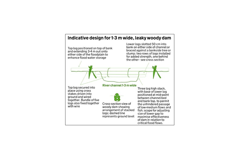
Indicative design for leaky wood dam 1 to 3m wide
Large leaky woody dam (RP33) – 3m to 5m wide
Indicative design for 3m to 5m wide, leaky woody dam.
- A cross section view of a 4 log high woody dam shows the arrangement of the stacked logs – 2 logs at the base with another 2 logs directly on top of them, then another 2 logs directly on top of those. The final log is at the top of the log stack, positioned in the dip between the 2 logs below it. Ground level is shown as being between the second and third row of logs from the bottom.
- The base of the lower logs is positioned at mid-point between the channel bed and bank top, to permit the unhindered passage of low-medium flows and fish. There is scope for adjusting the size of the lower gap to maximise the effectiveness of the dam in relation to critical flood flows.
- The lower logs are slotted 50cm into the bank on either side of the channel or braced against a bankside tree or stump. There are 2 rows of logs installed for added strength, one behind the other.
- The top 2 logs are positioned on top of bank and extend 5 to 6m out onto either side of the floodplain to enhance flood water storage. There are 2 rows of logs used at ground level for added stability.
- The top 2 logs are secured into place using cross stakes driven into the ground and wired together. Bundle of 7 logs also fixed together with wire.
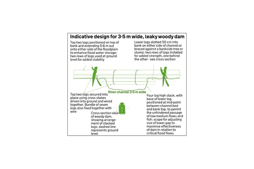
Indicative design for leaky wood dam 3 to 5m wide
Annex 2d: List of Higher Tier capital items and management options which support biodiversity
Habitat creation, restoration and management options, or arable options, can improve biodiversity or species recovery. These options can create or improve habitat connectivity to allow species to:
- move or colonise freely to get to food, shelter or breeding habitats
- adapt to environmental or climate change
Table 5: Capital items
| Code | Capital item name |
|---|---|
| BN3 | Earth bank creation |
| BN4 | Earth bank restoration |
| BN5 | Hedgerow laying |
| BN6 | Hedgerow coppicing |
| BN7 | Hedgerow gapping-up |
| BN10 | Hedgerow supplement – top binding and staking |
| BN11 | Planting new hedges |
| FG1 | Fencing |
| FG14 | Badger gates |
| FG15 | Water gates |
| FG2 | Sheep netting |
| FG7 | Anti-predator combination fencing |
| FM2 | Major preparatory works for priority habitats (creation and restoration) and priority species |
| RP1 | Resurfacing of gateways |
| RP2 | Gateway relocation |
| RP3 | Watercourse crossings |
| RP4 | Livestock and machinery hardcore tracks |
| RP5 | Cross drains |
| RP6 | Installation of piped culverts in ditches |
| RP7 | Sediment ponds and traps |
| RP8 | Constructed wetlands for the treatment of pollution |
| RP9 | Earth banks and soil bunds |
| RP10 | Silt filtration dams or seepage barriers |
| RP11 | Swales |
| RP12 | Check dams and woody debris structures |
| RP13 | Yard – underground drainage pipework |
| RP14 | Yard inspection pit |
| RP15 | Concrete yard renewal |
| RP16 | Rainwater goods |
| RP17 | Storage tanks underground |
| RP18 | Above ground tanks |
| RP19 | First-flush rainwater diverters and downpipe filters |
| RP20 | Relocation of sheep dips and pens |
| RP21 | Relocation of sheep pens only |
| RP22 | Sheep dip drainage aprons and sumps |
| RP23 | Installation of livestock drinking troughs (in draining pens for freshly dipped sheep) |
| RP24 | Lined biobed plus pesticide loading and washdown area |
| RP25 | Lined biobed with existing washdown area |
| RP26 | Biofilters |
| RP27 | Sprayer or applicator load and wash-down area |
| RP28 | Roofing (sprayer washdown area, manure storage area, livestock gathering area, slurry stores, silage stores) |
| RP29 | Self-supporting covers for slurry and anaerobic digestate stores |
| RP30 | Floating covers for slurry and anaerobic digestate stores and lagoons |
| RP31 | Equipment to disrupt tramlines in arable areas |
| RP33 | Large leaky woody dam (3m to 5m) Indicative designs for large leaky woody dams are in annex 2c |
| TE3 | Planting fruit trees |
| TE4 | Supply and plant tree |
| TE5 | Supplement for use of individual tree-shelters |
| WB1 | Small wildlife box |
| WB2 | Medium wildlife box |
| WB3 | Large wildlife box |
| WN5 | Pond management (100m2 or less) |
| WN6 | Pond management (more than 100m2) |
| WN7 | Restoration of large water bodies |
Table 6: Management options
| Code | Management option name |
|---|---|
| AB1 | Nectar flower mix |
| AB2 | Basic overwinter stubble |
| AB3 | Beetle banks |
| AB4 | Skylark plots |
| AB5 | Nesting plots for lapwing and stone curlew |
| AB6 | Enhanced overwinter stubble |
| AB7 | Whole crop cereals |
| AB8 | Flower-rich margins and plots |
| AB9 | Winter bird food |
| AB10 | Unharvested cereal headland |
| AB11 | Cultivated areas for arable plants |
| AB12 | Supplementary winter feeding for farmland birds |
| AB15 | Two-year sown legume fallow |
| AB16 | Autumn sown bumblebird mix |
| BE3 | Management of hedgerows |
| BE4 | Management of traditional orchard |
| BE5 | Creation of traditional orchards |
| CT1 | Management of coastal sand dunes and vegetated shingle |
| CT2 | Creation of coastal sand dunes and vegetated shingle on arable land and improved grassland |
| CT3 | Management of coastal saltmarsh |
| CT4 | Creation of inter-tidal and saline habitat on arable land |
| CT5 | Creation of inter-tidal and saline habitat by non-intervention |
| CT7 | Creation of inter-tidal and saline habitat on intensive grassland |
| GS1 | Take field corners out of management |
| GS2 | Permanent grassland with very low inputs (outside SDAs) |
| GS3 | Ryegrass seed-set as winter food for birds |
| GS4 | Legume and herb-rich swards |
| GS5 | Permanent grassland with very low inputs in SDAs |
| GS7 | Restoration towards species-rich grassland |
| GS8 | Creation of species-rich grassland |
| GS9 | Management of wet grassland for breeding waders |
| GS10 | Management of wet grassland for wintering waders and wildfowl |
| GS11 | Creation of wet grassland for breeding waders |
| GS12 | Creation of wet grassland for wintering waders and wildfowl |
| GS13 | Management of grassland for target features |
| GS14 | Creation of grassland for target features |
| GS17 | Lenient grazing supplement |
| LH1 | Management of lowland heathland |
| LH2 | Restoration of forestry and woodland to lowland heathland |
| LH3 | Creation of heathland from arable or improved grassland |
| OP1 | Overwintered stubble |
| OP2 | Wild bird seed mixture |
| OP3 | Supplementary feeding for farmland birds |
| OP4 | Multi species ley |
| OP5 | Undersown cereal |
| OR2 | Organic conversion – unimproved permanent grassland |
| OT1 | Organic land management – improved permanent grassland |
| OT2 | Organic land management – unimproved permanent grassland |
| OT3 | Organic land management – rotational land |
| SP2 | Raised water level supplement |
| SP3 | Bracken control supplement |
| SP4 | Control of invasive plant species supplement |
| SP5 | Shepherding supplement |
| SP6 | Cattle grazing supplement |
| SP8 | Native breeds at risk supplement |
| SP9 | Threatened species supplement |
| SW1 | 4m to 6m buffer strip on cultivated land |
| SW3 | In-field grass strips |
| SW4 | 12m to 24m next to terrestrial sites which are sensitive to nitrogen |
| SW5 | Enhanced management of maize crops |
| SW6 | Winter cover crops |
| SW7 | Arable reversion to grassland with low fertiliser input |
| SW8 | Management of intensive grassland adjacent to a watercourse |
| SW9 | Seasonal livestock removal on intensive grassland |
| SW10 | Seasonal livestock removal on grassland in SDAs next to streams, rivers and lakes |
| SW11 | Riparian management strip |
| SW12 | Making space for water |
| SW13 | Very low nitrogen inputs to groundwaters |
| SW14 | Nil fertiliser supplement |
| SW17 | Raised water level on cropped or arable land on peat soils |
| SW18 | Raised water levels on grassland on peat soils |
| UP1 | Enclosed rough grazing |
| UP2 | Management of rough grazing for birds |
| UP3 | Management of moorland |
| UP4 | Management of moorland vegetation supplement |
| UP5 | Moorland re-wetting supplement |
| WD2 | Woodland improvement |
| WD3 | Woodland edges on arable land |
| WD7 | Management of successional areas and scrub |
| WD8 | Creation of successional areas and scrub |
| WD9 | Livestock exclusion supplement – scrub and successional areas |
| WT1 | Buffering in-field ponds and ditches in improved grassland |
| WT2 | Buffering in-field ponds and ditches on arable land |
| WT4 | Management of ponds of high wildlife value (100m2 or less) |
| WT5 | Management of ponds of high wildlife value (more than 100m2) |
| WT8 | Management of fen |
| WT9 | Creation of fen |
Annex 3: How Higher Tier applications are scored
All eligible initial applications for Higher Tier are scored, except those with organic management and conversion-only options.
Agri-environment-only applications
Tables 7 and 12 show how agri-environment-only applications are scored and ranked.
A national threshold is set based on the available budget. If your application scores above this threshold, a Natural England adviser will offer support to help you develop a final application. At Defra’s discretion, Natural England may be able to offer support to develop some applications that score below the national threshold.
We give a score for features that need management only available in Higher Tier. You can include features suited to Mid Tier management in your Higher Tier application, but they will not contribute to your score.
If we reject your application following Higher Tier scoring, Mid Tier may be more suitable for your holding.
Organic management and conversion options are not scored. If you apply for these options and you meet the eligibility requirements, we will offer you an agreement. If your Higher Tier application fails the overall scoring process, you will be given the option to continue with an agreement that contains just the organic management and conversion options.
Woodland-only applications
If you are applying for Higher Tier WD2 Woodland Improvement or capital items, you will need to score your initial application yourself. Follow the guidance in annex 5 and in ‘How to complete the Countryside Stewardship Higher Tier application form’ that is included with your application pack.
The Forestry Commission ranks the applications by score and a national threshold is set. If your application scores above this threshold, a Forestry Commission adviser will offer support to help you develop a final application. The adviser will confirm the final score for your application for woodland improvement while working with you.
Once the deadline for submitting final applications has passed, applications will be ranked by their agreed scores and a threshold set. If your application scores above this threshold, we will offer you an agreement.
Mixed option applications
Natural England and the Forestry Commission use a combination of the methods to score an initial application that contains both agri-environment and woodland parts. If the agri-environment part of your mixed application is rejected, you might be able to continue with a woodland-only application, or Mid Tier may be more suitable for your holding. If the woodland part is rejected, you may be able to continue with an agri-environment-only application.
Step 1 – Basic score for land-based features
This is for priority habitats, water quality and historic environment features or issues.
To receive a score they must be included in the initial application and require management only available under Higher Tier. Most priority habitats also have a minimum area requirement below which they are not scored – see tables 9, 10 and 11.
Scoring criteria
- Each of these features on the holding has a priority level of High, Medium or Low. These are taken at the Rural Payments service land parcel level. They are as described in local priority statements and targeting maps and in tables 9, 10 and 11. Each priority level has an associated baseline priority score.
- Historic environment features simply score the baseline priority score for each parcel (field) offered that will support that feature.
- Each priority habitat feature or water quality issue has its own ‘value per unit’ to consider in addition to the baseline priority score. These values are based on the priority level, location and comparative rarity of each feature. These are shown in tables 9, 10 and 11 and in most cases the units are hectares. For each of these features or issues, the score is calculated as: baseline priority score + (number of units x value per unit).
- Where multiple features or issues appear in a parcel, that parcel can score for each feature or issue.
The sum of these scores provides the basic score for land–based features. Where priority habitats occur on SSSIs an additional score will be applied (see additional scores).
Scoring process
Table 7: Higher Tier scoring process for agri-environment-only and mixed initial applications
| Priority level | Baseline priority score |
|---|---|
| High | 1,000 |
| Medium | 100 |
| Low | 10 |
Example 1: Priority habitat
4ha of lowland heathland priority habitat.
Lowland heathland is a high priority so its baseline priority score is 1,000 points.
Its value per unit is 100 points per hectare.
The score is calculated as: 1,000 + (4 x 100) = 1,400 points.
Example 2: Historic environment (HE)
One high priority HE feature across 2 parcels and 3 medium priority HE features on 3 parcels.
The score is calculated as: (2 x 1,000) + (3 x 100) = 2,300 points.
Step 2 – Species score
This is for the:
- wildlife pollinator farm wildlife package (WPFWP) Section 41 (S41) Species requiring bespoke management (as defined in the NERC Act)
- woodland bird assemblage and breeding wader assemblage (as referred to in the statement of priorities)
To receive a score, they must be included in the initial application. These features have minimum area requirements, below which they are not scored – see table 12.
Criteria
These are scored in the same way as priority habitats in Step 1: baseline priority score + (value per unit x the number of units).
Except that if the area has already been scored for priority habitat, the baseline priority score alone is counted.
Check the information in table 12 for the priority levels and value per hectare scores for these features. They are all high priority features so the Baseline Priority Score is 1,000 points for all of them.
For the WPFWP the value per unit is 30 points per unit. The unit to be scored is the area, in hectares, of the arable, temporary grass and permanent grassland parcels to be included, excluding any areas of priority habitat grassland.
For S41 species requiring bespoke management, woodland bird assemblage and breeding wader assemblage the value per unit is 100 points per unit. The unit to be scored is the area in hectares being managed for the species or assemblage.
Three species in the breeding wader assemblage are also S41 species requiring bespoke management. These species score as above as an S41 species and additionally receive the baseline priority score (1,000 points) for the assemblage.
The sum of the individual species category scores provides a species score.
Scoring process
Table 8
| Species category | Species score calculation |
|---|---|
| WPFWP | Baseline priority score + (value per unit x units) |
| S41 or Woodland bird assemblages or breeding waders on priority habitat | Baseline priority score |
| S41 or Woodland bird assemblages or breeding waders on non-priority habitat | Baseline priority score + (value per unit x units) |
| S41 and breeding waders | Baseline priority score + S41 score |
Species score = sum of species category scores.
Example 1: WPFWP
Farmed land (50ha) proposed for the WPFWP in a target area. Baseline priority score (high) = 1000 points. Value per unit = 30 points per hectare. Score = 1000 + (30 x 50) = 2,500 points.
Example 2: curlew (a S41 species)
Rough grazing land (20ha) proposed for management to benefit curlew.
Curlew is an S41 species requiring bespoke management and is in the breeding wader assemblage.
S41 species baseline priority score = 1,000 points.
S41 species value per unit = 100 points per hectare.
S41 score = 1000 + (100 x 20) = 3,000 points.
The score for the wader assemblage is only the baseline priority score (1,000 points) because the area has already been scored for S41 species.
Step 3 – Calculate the total basic score
The total basic score is calculated by adding together the basic score for land based features and the species score.
Total basic score = basic score for land-based features + species score.
Step 4 – Calculate the additional score
SSSI: Applicant has included SSSI features.
Add 10% of total basic score, but only for the SSSI area.
Genetic conservation: applicant has included priority habitats where native breeds at risk are appropriate and have been proposed.
Add 5% to the total basic score.
Educational access proposed.
Add 5% to the total basic score.
Facilitation fund: Applicant confirmed as being part of a Facilitation Fund group.
Add 5% to the total basic score.
Step 5 – Calculate the final score
The final score is calculated by adding the total basic score and any additional scores.
Where no Higher Tier items are proposed the application will be ineligible and a score of 0 will be applied.
Final score = total basic score + any additional scores.
Step 6 – Ranking of all initial applications
If resource limitations require a threshold to be set, the final score is used to rank all the initial applications in the ‘pipeline’ for Higher Tier agreements.
Step 7 – Final applications
These are scored in the same way as the initial application.
If there is an issue resourcing the final agreements the scores between the final application and initial application are compared to confirm the offer remains the same.
Step 8 – Ranking of all applications
If resources are available all eligible final applications will be taken forward.
Value scores for habitats, water quality and historic environment
Table 9: Priority habitats
| Habitat | Option type | Minimum area | Priority level | Value per hectare score |
|---|---|---|---|---|
| Lowland calcareous grassland | Management/ restoration | 0.5ha | High | 100 |
| Lowland calcareous grassland | Creation | 0.5ha | High | 90 |
| Lowland dry acid grassland | Management/ restoration | 0.5ha | High | 100 |
| Lowland dry acid grassland | Creation | 0.5ha | High | 90 |
| Purple moor-grass and rush pasture | Management/ restoration | 0.5ha | High | 100 |
| Purple moor-grass and rush pasture | Creation | 0.5ha | High | 90 |
| Lowland meadows | Management/ restoration | 0.5ha | High | 200 |
| Lowland meadows | Creation | 0.5ha | High | 180 |
| Upland hay meadows | Management/ restoration | 0.5ha | High | 200 |
| Upland hay meadows | Creation | 0.5ha | High | 180 |
| Calaminarian grassland | Management/ restoration | 0.5ha | High | 200 |
| Calaminarian grassland | Creation | 0.5ha | High | 180 |
| Upland calcareous grassland | Management/ restoration | 2 ha | High | 100 |
| Upland calcareous grassland | Creation | 2ha | High | 90 |
| Lowland heath | Management/ restoration | 2ha | High | 100 |
| Lowland heath | Creation | 2ha | High | 90 |
| Upland heath (heather moorland) | Management/ restoration (no creation option) | 5ha | High | 10 |
| Blanket bog | Management/ restoration (no creation option) | Part of upland heath | High | 67 |
| Mountain heath and willow scrub | Management/ restoration (no creation option) | Part of upland heath | High | 100 |
| Inland rock outcrop and scree | N/A – Inland rock and scree does not score separately, but it is scored as part of the upland heath/heather moorland mosaic | N/A | N/A | N/A |
| Limestone pavement | Management/ restoration (no creation option) | 2ha | High | 100 |
| Upland flushes, fens and swamps | Management/ restoration (no creation option) | 0.5ha | High | 100 |
| Lowland fens | Management/ restoration | 0.5ha | High | 100 |
| Lowland fens | Creation | 0.5ha | High | 90 |
| Reedbeds | Management/ restoration | 2ha | High | 100 |
| Reedbeds | Creation | Creation | High | 90 |
| Lowland raised bogs | Management/ restoration (no creation option) | Management/ restoration (no creation option) | High | 200 |
| Coastal and floodplain grazing marsh where part of a wetland complex identified in the breeding wader strategy as an important focus area and either currently supports, or is capable of supporting, breeding waders; or on individual sites which support breeding wader assemblages and where water level management is part of proposal; or on areas with networks of ditches of high nature conservation value | Management/ restoration | Management/ restoration | High | 67 |
| Coastal and floodplain grazing marsh (as above) | Creation | 5ha | High | 60 |
| Maritime cliff and slope | Managed as grassland or heathland | 250m | High | 4 per metre (length of cliff not height) |
| Coastal saltmarsh | Management/ restoration | 5ha | High | 67 |
| Coastal saltmarsh | Creation | 5ha | High | 60 |
| Coastal sand dunes | Management/ restoration | 5ha | High | 67 |
| Coastal sand dunes | Creation | 5ha | High | 60 |
| Saline lagoons | No direct management options under the scheme | Would score as a scheme priority under water quality measures below, if applicable | N/A | |
| Wood pasture and parkland | Management/ restoration | 5ha | High | 20 |
| Wood pasture | Creation | 5ha | High | 18 |
| Traditional orchards | Management/ restoration | 2ha unless part of orchard network | High | 500 |
| Traditional orchards | Creation | 2ha unless part of orchard network | High | 450 |
| Riparian habitats associated priority lakes and rivers | Management/ restoration | 0.5ha | High | 100 |
| Riparian habitats associated priority lakes and rivers | Creation | 0.5ha | High | 90 |
| Woodland – high priority | Management/ restoration | 0.5ha | High | 100 |
| Woodland – medium priority | Management/ restoration | 0.5ha | Medium | 10 |
| Woodland – low priority | Management/ restoration | 0.5ha | Medium | 1 |
Table 10: Water quality
| Water quality and flood risk management | Minimum area | Priority level | Value per hectare score |
|---|---|---|---|
| Nitrogen | None defined | High | 50 |
| Phosphorous | None defined | High | 50 |
| Sediment | None defined | High | 50 |
| Faecal coliforms | None defined | High | 50 |
| Pesticides | None defined | High | 50 |
| Flood risk management | None defined | High | 50 |
| Nitrogen | None defined | Medium | 5 |
| Phosphorous | None defined | Medium | 5 |
| Sediment | None defined | Medium | 5 |
| Faecal coliforms | None defined | Medium | 5 |
| Pesticides | None defined | Medium | 5 |
| Flood risk management | None defined | Medium | 5 |
| Nitrogen | None defined | Low | 0.5 |
| Phosphorous | None defined | Low | 0.5 |
| Sediment | None defined | Low | 0.5 |
| Faecal coliforms | None defined | Low | 0.5 |
| Pesticides | None defined | Low | 0.5 |
| Flood risk management | None defined | Low | 0.5 |
| Unmanaged conifer to meet UKFS within catchments subject to eutrophication and acidification to reduce pressure on the water environment | 0.5ha | High | 100 |
Table 11: Historic environment
| Historic environment (HE) | Priority level | Value per parcel score |
|---|---|---|
| Heritage at risk – designated HE features that appear on the EH register as ‘high risk’ | High | 1,000 |
| Prioritised historic buildings – high priority for restoration | High | 1,000 |
| SHINE 4 high significance | High | 1,000 |
| National designations at medium and low risk – designated HE features that are currently rated as ‘medium’ or ‘low’ risk on the EH register | High | 1,000 |
| SHINE medium and low significance | Medium | 100 |
| Designated and undesignated traditional farm buildings in need of maintenance | Medium | 100 |
| Priority undesignated historic parklands | Medium | 100 |
Table 12: Value scores for biodiversity priorities
| Biodiversity priority | Minimum area | Priority level | Value per hectare score |
|---|---|---|---|
| Wild pollinator and farm wildlife package | 5% of relevant land under WPFWP options | High | 30 |
| S. 41 species with bespoke management needs (the 100 points per hectare area score and 0.5ha minimum threshold only apply to bespoke species occurring on non-priority habitats and outside WPFWP areas where we have sufficiently detailed data – in 2015 this was for birds and butterflies. Where bespoke species occur on priority habitat they will score the area score for that habitat and will need to meet the minimum threshold for that habitat, which may be different, as listed earlier in the annex) | 0.5ha | High | 100 |
| Woodland bird assemblage | 0.5ha | High | No area score |
| Breeding wader assemblages (the 0.5ha minimum threshold only applies to breeding wader assemblages occurring on non-priority habitats. Where breeding wader assemblages occur on priority habitat they will need to meet the minimum threshold for that habitat, which may be different, as listed earlier in the annex) | 0.5ha | High | 100 per ha unless area already scored for PH, WPFWP or S. 41 |
Annex 4: Applying for the Higher Tier Wild Pollinator and Farm Wildlife Packages
The Higher Tier WPFWP groups together selected management options. These options help you to provide farmland wildlife with the essential resources they need to thrive and breed successfully.
If you include the WPFWP in your application, it will increase your application’s score. Applications with a higher score are more likely to be offered an agreement.
Benefits for wildlife
A Higher Tier WPFWP will help you to support your local wildlife, such as:
- wild pollinators – solitary bees and bumble bees
- farmland birds – grey partridge, skylark and yellowhammer
- other farmland wildlife – rare arable plants, great crested newts, bats and brown hare
How the WPFWP works
The package focuses on the farmed land on your holding and includes a range of management options. These options help you to provide essential resources for wildlife, including:
- nectar and pollen sources for insect pollinators and insect-rich foraging for birds.
- nesting, hibernation and shelter for insect pollinators and birds
- winter food for seed-eating birds
Tables 13 to 16 list these options. You can also choose from additional options in table 17.
Choosing more options is usually better for wildlife because you will provide a greater range of habitats and food or nesting resources. As with all Higher Tier, you must meet the management requirements for each of the options you choose.
Section 4.2 sets out the support that is available when choosing options. You must:
- meet the minimum requirements for each of the essential resource categories measured in hectares (or in metres for the hedge and ditch options)
- make sure that the area covered by the package options is at least 5% of the total area of farmed land included in your application – depending on the options you choose, you may be required to commit more than 5%
You can add a range of other management options and capital items in addition to your WPFWP package with Higher Tier.
Who can apply for Higher Tier WPFWP
To be considered for the Higher Tier WPFWP you must either:
- have an ES agreement that is coming to an end – your agreement must have included management options that focused on farmed wildlife and must have been successful based on the quality of options delivered or evidence of biological responses by key farmland species, or both
- have a holding that meets the qualifying criteria for range-restricted farmland bird assemblages or wild bee species, or both (you should check your holding on MAGIC maps – to qualify, your holding must be partly or wholly located in tetrad (2km by 2km recording square) that supports 3 of the 6 range-restricted farmland bird assemblages or 7 of the 13 wild bee species associated with the wider countryside, or both)
Scoring and the WPFWP
If you meet the minimum requirements of the WPFWP, your application score will automatically receive an increase.
You can read information on scoring in annex 3.
Eligible land
The WPFWP can only be located on BPS-declared arable land, temporary grassland and permanent grassland. All other land uses are excluded from this package. You must also meet the eligibility criteria for the Higher Tier. Read section 3.
Tools to help you decide how much land to include
You can use the information in the tables provided to make your calculations.
Not all land needs to be included in your application for WPFWP, it can cover either the whole or part of your farm.
You must meet the minimum requirements of the package.
You can choose to include more land than the minimum in your application.
Maximise the benefit for farmed wildlife
To maximise benefits from the WPFWP, you should:
- choose more options and spread the location of the options across the farm
- select both legume and perennial flower-based mixes to provide nectar and pollen sources for a longer period of time over the summer and autumn
- spread options delivering nectar and pollen across the farm, so that it benefits as many wild pollinators and birds as possible
- choose the hedgerow management option – well-managed hedgerows can provide valuable spring foraging for wild pollinators, as well as good nesting habitat for birds
- create a mixture of habitats, from tussocky, uncut grass to areas of warm, dry, bare ground that remain undisturbed for the breeding cycle to provide wild pollinators and farmland birds places to nest, shelter and overwinter or hibernate
- provide both annual and biennial wild bird seed mixes to benefit a broader range of farmland birds
- place skylark plots over some or all of the area of winter cereal crops
- stubble following a crop of spring-sown barley
- consider selecting one or more additional options to focus on particular species or features
Look at tables 18 to 20 for examples of typical arable, pastoral, mixed farm combinations.
How to build a Higher Tier WPFWP
- Work out the area of land that is eligible and decide how much to include in your application.
- Use table 13 to 16 to choose your options. You must choose options that meet the minimum requirements for each essential resource.
- Make sure that you manage any Scheduled Monuments appropriately
- Choose how many hectares you want to enter into each option (or how many metres for hedgerows and ditches). You must meet the minimum requirements for each essential resource.
- Generally choosing more options is better for farmed wildlife. Consider whether you can include more than the minimum requirements. You may wish to include additional options from table 17.
- Check that you have met the minimum requirements of the package. You can use the information in the tables provided to make your calculations.
- Fill in your Higher Tier application form as set out in section 4, adding in any other options and capital items that you wish to apply for.
Using the WPFWP tables
There is a table for each essential resource, and a table for additional options.
The minimum and maximum amounts of each resource (for 100ha of eligible land) are given in the tables. You should adjust these on a ‘pro rata’ basis. For example, if you have 250ha of eligible land, then multiply the quantities by 2.5.
Essential resource 1: Nectar and pollen sources for insect pollinators and insect-rich foraging for birds.
You must meet the minimum quantity for spring flowering and summer or autumn flowering.
Table 13: A – Spring flowering
The following options can be used on their own or in combination to achieve the minimum. Example combination – 250m of BE3 and 0.25ha of AB11.
| Option | Minimum quantity per 100ha |
|---|---|
| BE3 Management of hedgerows | 500m |
| WT3 Management of ditches of high environmental value | 500m |
| WT1 Buffering in-field ponds and ditches in improved grassland | 0.5ha |
| WT2 Buffering in-field ponds and ditches on arable land | 0.5ha |
| WD3 Woodland edges on arable land | 0.5ha |
| AB11 Cultivated areas for arable plants (autumn-cultivated only) | 0.5ha |
Table 14: B – Summer or Autumn flowering
The following options can be used on their own or in combination to achieve the minimum. Example combination – 0.5ha each of AB1, AB8 and AB11.
| Option | Minimum quantity per 100ha |
|---|---|
| AB1 Nectar flower mix | 1.5ha |
| AB8 Flower-rich margins and plots | 1.5ha |
| AB11 Cultivated areas for arable plants | 1.5ha |
| AB15 Two-year sown legume fallow | 1.5ha |
| AB16 Autumn sown bumblebird mix | 1.5ha |
| GS4 Legume and herb-rich swards (or OP4 Multi-species ley) | 1.5ha |
Essential resource 2: Nesting, hibernation and sheltering habitat for insect pollinators and birds
You must choose at least one of the following options to meet the minimum quantity.
Table 15
| Option | Minimum quantity per 100ha |
|---|---|
| SW1 4m to 6m buffer strip on cultivated land | 1ha |
| SW4 12m to 24m watercourse buffer strip on cultivated land AB3 Beetle banks | 1ha |
| AB5 Nesting plots for lapwing and stone curlew | 1ha |
| AB11 Cultivated areas for arable plants | 1ha |
| AB14 Harvested low input cereal | 1ha |
| GS1 Take small areas out of management | 1ha |
| GS13 Management of grassland for target features | 1ha |
| GS17 Lenient grazing supplement | 1ha |
Essential resource 3: Winter food for seed-eating birds
Choose either option: AB9 Winter bird food (or OP2 Wild bird seed mixture) – minimum quantity per 100ha = 2ha.
You can combine AB9 Winter bird food (or OP2 Wild bird seed mixture) – minimum quantity per 100ha = 1ha with one of the options below. This is based on the following formula: 1ha of AB9/OP2, AB10 or GS3 = 2.5ha of AB6/AB16 = 5ha of AB2/OP1/AB7.
Table 16
| Option | Minimum quantity per 100ha |
|---|---|
| AB10 Unharvested cereal headland | 1ha |
| GS3 Ryegrass seed-set as winter food for birds | 1ha |
| AB6 Enhanced overwinter stubble | 2.5ha |
| AB16 Autumn sown bumblebird mix | 2.5ha |
| AB2 Basic overwinter stubble (or OP1 Overwintered stubble) | 5ha |
| AB7 Whole crop cereals | 5ha |
Table 17: Additional options focussing on specific species or features on the holding that may require management
The options in table 17 are voluntary. You can use them to help you manage specific species on your holding and you can improve your application by adding these options.
| Species or feature requiring management | Select one or more of the following options |
|---|---|
| In-field trees | BE1 Protection of in-field trees on arable land BE2 Protection of in-field trees on intensive grassland |
| Ponds | WT4 Management of ponds of high wildlife value (100m2 or less) WT5 Management of ponds of high wildlife value (more than 100m2) |
| Supplementary food for seed-eating birds | AB12 Supplementary winter feeding for farmland birds (or OP3 Supplementary feeding for farmland birds) |
| In-field breeding habitats for skylarks in landscapes dominated by winter cereals | AB4 Skylark plots |
| Traditional orchards | BE4 Management of traditional orchards |
| Nest/roost boxes for insects, tree sparrows and bats | WB1 Small wildlife box WB2 Medium wildlife box WB3 Large wildlife box (all are capital items) |
Examples of typical arable, pastoral, mixed farm combinations
Example 1
Arable holding on medium–heavy land (all winter cropping) with good hedgerows. Coming out of an HLS agreement that was effectively delivering the HLS Farmland Bird package and is within 3 of 6 farmland bird tetrad.
Criteria (plus additional priorities): meets both criteria A and B (no bespoke species present but within an area of high ELS or Mid Tier uptake).
The percentage of farmed land covered by options for this scenario is 4.5%.
The total value of the agreement per annum per 100ha of farmed land entered into the agreement for this scenario is Total cost pa = £3,834.50.
Notes:
- 100m of extra hedgerow negotiated
- flower-rich margins, nectar mix and buffer strips should be spread around the holding, adjacent to managed hedgerows where possible
- winter bird food should be a mix of annual and biennial mixtures
Table 18
| Options (areas are per 100ha of farmed land entered into the agreement) | Rate per annum (£) | Essential resources – Food/fuel and insect food | Essential resources – Nesting | Essential resources – Winter bird food | Additional options |
|---|---|---|---|---|---|
| 1500m BE3 Management of hedgerows of high environmental value (both sides) at £10 per 100m per side | £300 | Spring | X | ||
| 0.5ha AB8 Flower rich margins and plots (0.5*£673) | £336.50 | Summer/ autumn | X | ||
| 1ha AB1 Nectar flower mix | £614 | Summer/ autumn | |||
| 1ha SW1 (4m to 6m buffer strip on cultivated land | £451 | X | |||
| 2ha AB9 Winter bird food (2*£732) | £1464 | X | |||
| AB12 supplementary feeding on 2ha of winter bird food | £669 | X |
Example 2
Mixed holding on light soil which retains some spring cropping and unimproved grassland, but with no decent hedgerows. Coming out of an HLS agreement that was effectively delivering the HLS Farmland Bird package, including fallow plots which support breeding lapwing, and is within 3 of 6 farmland bird tetrad.
Criteria (plus additional priorities): meets both criteria A and B (Lapwing present and there is a small area of decent unimproved grassland).
The percentage of farmed land covered by options for this scenario is 10% of arable although 5ha as stubble still in production with spring cropping; plus 1% of grassland (but still productive).
The total value of the agreement per annum per 100ha of farmed land entered into the agreement for this scenario is total cost per annum = £3,908.
Notes:
- cultivated plots are autumn-sown
- cultivated arable plant plots, fallow plots and grassland provide multiple nesting opportunities for pollinators
- lapwing nesting plots should, ideally, be located near to unimproved grassland (provided arable fields are suitable)
Table 19
| Options (areas are per 100ha of farmed land entered into the agreement) | Rate per annum (£) | Essential resources – Food/fuel and insect food | Essential resources – Nesting | Essential resources – Winter bird food | Additional options |
|---|---|---|---|---|---|
| 1ha AB1 Nectar Flower mix | £614 | summer/ autumn | |||
| 0.5ha AB11 Cultivated areas for arable plants (0.5*£550) | £275 | spring | X | ||
| 0.5ha AB8 Flower rich margins and plots (0.5*£673) | £336.50 | summer/ autumn | |||
| 1ha AB9 Winter Bird Food | £732 | X | |||
| 5ha AB2 Basic overwinter stubble (5 * £58) | £290 | X | |||
| AB12 supplementary feeding on 1ha of Winter bird food | £669 | X | |||
| 2ha AB5 Nesting plots for lapwing and stone curlew (2*£587) | £1174 | X | |||
| 1ha GS13 Management of grassland for target features | £152 | X |
Example 3
A 100% grass holding that has some fields cut for silage and some high quality hedgerows and ponds, and areas of semi/unimproved grassland. Within 7 of 13 pollinator tetrad.
Criteria (plus additional priorities): meets criteria B (decent unimproved grassland, bats present and has several decent ponds).
The percentage of farmed land covered by options for this scenario is 5.5% of grassland, but only 0.5% taken completely out of production (as field corners). Only 3.5% if rye-grass seed-set option is not used (read ‘Notes’).
The total value of the agreement per annum per 100ha of farmed land entered into the agreement for this scenario is total cost per aannum = £2,393.50 extra hedgerow and pond buffering negotiated.
Notes:
- rye grass set-seed option could be removed on farms outside of farmland bird target areas
Table 20
| Options (areas are per 100ha of farmed land entered into the agreement) | Rate per annum (£) | Essential resources – Food/fuel and insect food | Essential resources – Nesting | Essential resources – Winter bird food | Additional options |
|---|---|---|---|---|---|
| 1000m BE3 Management of hedgerows of high environmental value (both sides at £10 per 100m per side) | £200 | Spring | |||
| 1.5ha GS4 Legume and herb-rich swards (at £382 per ha) | £573 | Summer/ autumn | |||
| 1 WT4 Maintenance of ponds of high wildlife value <100m2 | £119 | X | |||
| 1ha of WT1 Buffering in-field ponds on improved grassland | £311 | Spring | |||
| 0.5ha GS1 Take field corners out of management (outside SDA) (0.5*£333) | £166.50 | X | |||
| 0.5ha GS13 Management of grassland for target features (0.5*£152) | £76 | X | |||
| 2ha GS3 Ryegrass seed – set as winter/spring food for birds (2*£474) | £948 | X |
Annex 5: Woodland improvement
This annex provides information to support Higher Tier applications for woodland improvement using multi-year options and capital items.
Requirements for a Woodland Management Plan (WMP)
If you’re applying for a CS Higher Tier agreement on woodland, you must have a Forestry Commission approved WMP covering all the woodland in your agreement.
You must have an approved WMP throughout the 5-year period of your Higher Tier agreement, so if your WMP ends before your Higher Tier agreement, you will need to apply for a WMP for the remaining time. You can apply within the last year of your existing WMP, but to avoid double funding there must be no overlap of WMP start and end dates.
Your WMP must be fully approved with any associated felling licence in place by 31 August.
If your land contains an SSSI, in or outside of woodland, you must contact Natural England before the CS agreement starts, as it must approve any new WMP alongside an SSSI ‘supplementary notice of operations’. If the SSSI is found to be in poor condition, a feasibility study (PA2) may also be required before a Higher Tier application can begin.
You can contact Natural England by email at enquiries@naturalengland.org.uk or by telephone on 0300 060 3900.
Where your CS application includes historic environment multi-year options, or capital items within the woodland, work related to Scheduled Monuments may require Historic England consent. This can either be obtained separately, or alongside the Forestry Commission’s approval of your WMP.
Historic environment options and capital items, and veteran tree surgery are now eligible with the woodland improvement option WD2 . This means your application will remain woodland only. Please use the grant finder to help locate options and grants.
For woodland applications please complete:
- historic environment capital option(s) on the application form annex 2c
- historical environment and veteran tree surgery multi-year options on annex 2h
If your Higher Tier application includes any agri-environment element, it is a mixed application, as the historic environment capital items and multi-annual options, and veteran tree surgery multi-annual options will be applied to land parcels outside woodland.
For mixed applications please complete:
- annex 1b, non-rotational options for historical environment (HS1, HS4, HS6 and HS8) and veteran tree surgery (BE6) multi-annual options
- annex 1e for historical environment capital items HE1 and HE3
You can contact Historic England by email at customers@HistoricEngland.org.uk or by telephone on 0370 333 0607.
Your WMP must support your Higher Tier application requirements under the WD2 or historic environment options and show why you need the capital items included in your application.
You can read more information about WMPs including information about funding and download the templates from Create a woodland management plan.
You can use other templates needed for a Forestry Commission approved UKFS compliant WMP. For example, a WMP can be produced to gain access to the UK Woodland Assurance Scheme (UKWAS), but only Forestry Commission templates must be used for your WMP using the CS WMP grant.
Amending WMPs to support CS applications
You may find your current WMP does not support your CS Higher Tier application. For example, an older WMP might not:
- accurately reflect the current woodland management objectives
- fully address the current constraints and threats affecting woodland management
- be compliant with the current UKFS standard (revised 2017)
You may be able to make amendments to your WMP as part of making your Higher Tier application, depending on the type needed. You need to discuss any changes with your Woodland Officer as soon as possible as Forestry Commission approval is needed by 31 August.
To get this approval you might have to:
- hold discussions with relevant stakeholders
- apply for and get additional felling permissions
- arrange for any other consents needed
Submit your amended WMP to your local Forestry Commission woodland officer, allowing enough time for approval.
It is unlikely that major amendments to an existing funded PA3 WMP could be approved in time. Forestry Commission woodland officers can advise if you are eligible for new PA3 or not and on the likelihood of amendments being approved in time.
It’s important to remember that:
- a Forestry Commission WMP must be approved or approved in principle to support an eligible CS application by the initial application submission deadline of 28 April 2023
- where a WMP is approved in principle at the deadline for initial applications, the felling consents and permissions must be completed and a felling licence in place by the final application deadlines given above
- where the WMP needs an amendment so that it supports management options or item requests (for example if using WD2 to support a priority objective that is not within the existing WMP), the WMP must be amended and approved by the final application deadlines given above
Eligible area and value thresholds
To be eligible for Higher Tier the total area of woodland in your application must be 3ha or more (unless the woodland is an SSSI, in which case this threshold is lowered to 1ha). The total area for the application can be made up of separate blocks of woodland, but the minimum size for these blocks is 0.5ha.
To be eligible for Higher Tier Woodland Improvement, the land parcels must be registered with a land use of WO12 – woodland, on the Rural Payments service. Read Forestry Commission operations Note 42 for more information about this.
If you are making a mixed application for both agri-environment and woodland options, the 3-hectare minimum application size still applies, but this can be made up of land containing both woodland and agri-environment options and items. The 0.5-hectare minimum block size for woodland still applies.
Table 21 lists the minimum agreement and block sizes, as well as the minimum total value of capital items within a single agreement.
Table 21: Higher Tier woodland applications minimum requirements
| Area or capital item | Minimum area for individual block (hectare) | Minimum agreement requirement (hectare) |
|---|---|---|
| Overall area | 0.5 | 3ha woodland-only; 1ha woodland SSSI; 0.5ha of woodland within a mixed application |
| Capital items (including infrastructure applications) | 0.5 | Minimum value £500 |
Application timeline for Higher Tier woodland applications
You must send your application to us by 28 April. We will not accept applications after this date.
All woodland applications must be made using the map and application pack available on request from us.
Rural Payments Agency (CS)
PO Box 324
Worksop
S95 1DF
Email: ruralpayments@defra.gov.uk
Telephone: 03000 200 301
Monday to Friday, 8:30am to 5pm, except bank holidays
Find out about call charges
Applicants should use the following timeline to submit their application.
- Request an agreement map and Higher Tier application pack as soon as possible. This is to allow initial applications to be received by 28 April.
- Sign and submit application form, including woodland annex and agreement map by 28 April.
- Develop an initial application with a Forestry Commission woodland officer, including a site visit, to create a final application with maps, scoring form and work specifications agreed.
- Sign and submit a completed final application with all requested supporting documentation to a Forestry Commission woodland officer, including maps, quotes, agreed revised score forms and work specifications, by 31 August .
Confirm acceptance of the agreement offered from November onwards.
Woodland Improvement multi-year option (WD2), other multi-year options, Woodland Infrastructure (FY2) and capital items
CS provides support for woodland improvement under the Higher Tier through the woodland improvement option (WD2) and capital items, including woodland infrastructure (FY2).
You can apply for WD2 and capital items where work will support:
- enhancing priority habitats
- enhancing priority species
- restoring PAWS
- improve resilience to climate change through CCF
Woodland Improvement option (WD2)
This is a multi-year option with a minimum £1,000 per year for 10ha or less, or £100 per hectare for 10ha or more, per year for 5 years. See the WD2: Woodland improvement guide to support this option.
Other multi-year options (HS1, HS4, HS6, HS8, BE6)
These are multi-year options which can be used to support the management of historic environment features in your woodland parcels. These are compatible and can be combined with WD2 to support a range of objectives compliant with the UKFS. Work included within these multi-year options (for example, scrub control under HS4) must not be included within the WD2 prescriptions (for example, P2007 ‘manage successional scrub’) or capital items (for example, support for scrub control via SB1 or SB2) applied to that parcel.
The multi-year option BE6 veteran tree surgery is to be linked with the individual trees included within the WD2 prescription with P2010.
The use of these multi-year options and supporting capital items is at the discretion of the Forestry Commission. The use of historic environment multi-year options will be required if your Historic Environmental Farm Environmental Record (HEFER) (see section 4.10.1) identifies essential work to Scheduled Monuments in woodland parcels.
For more information on these options, please use the grant finder.
Capital items
A number of capital items can be applied for to support woodland improvement. Some of these can be applied for on their own, and others have to be applied for with other capital items or the WD2 option.
Capital items that can be used stand alone or in association with WD2 are:
- AC1 – Access capital items
- BN12 – Stone wall restoration
- BN13 – Top Wiring – stone wall
- BN14 – Stone wall supplement – stone from quarry
- FG1 – Fencing
- FG2 – Sheep netting
- FG9 – Deer fencing
- FG10 – Temporary deer fencing
- FG11 – Deer exclosure plot
- FG16 – Deer pedestrian gate
- FG17 – Deer vehicle gate
- FY1 – Deer high seat
- FY2 – Woodland infrastructure
- RP32 – Small leaky woody dam (1m to 2.99m)
- RP33 – Large leaky woody dam (3m to 5m)
- SB1 – Scrub control and felling diseased trees
- SB2 – Scrub control – difficult sites
- SB6 – Rhododendron control
- TE10 – Coppicing bankside trees
- TE11 – Tree surgery
Capital items that can only be used in association with WD2 are:
- ED1 – Educational access
- FY3 – Squirrel Traps and Maintenance
- HE1 – Historic and archaeological feature protection
- HE3 – Removal of eyesore
- RP3 – Watercourse crossings
- RP5 – Cross drains
- RP6 – Installation of piped culverts in ditches
- SB4 – Chemical bracken control
- SB5 – Mechanical bracken control
- WB1 – Small wildlife box
- WB2 – Medium wildlife box
- WB3 – Large wildlife box
- WN5 – Pond management (100m2 or less)
- WN8 – Timber sluice
Supplementary capital items that can only be associated with other capital items are:
- AC2 – Countryside educational access
- FG4 – Rabbit fencing supplement
- FG5 – Fencing supplement – difficult sites
- FG12 – Wooden field gate
- FG14 – Badger gate
- FG15 – Water gates
Further details for each capital item can be found using the grant finder.
Multi-year and capital woodland improvement options and items can be applied for on the same land if they are complementary and not used to fund the same work.
Evidence and quotes for capital items
If you apply for woodland capital items, you might need photographs that show the proposed location of the capital item object or operation. You must keep this evidence as we may ask to see it.
You will need photographs to show the absence of any of the following capital items you are applying for:
- BN12 – Stone wall restoration
- BN13 – Top wiring – stone wall
- BN14 – Stone wall supplement – stone from quarry
- FG1 – Fencing
- FG2 – Sheep netting
- FG4 – Rabbit fencing supplement
- FG5 – Fencing supplement – difficult sites
- FG12 – Wooden field gate
- FG14 – Badger gates
- FG15 – Water gates
- HE1 – Historic and archaeological feature protection
- HE3 – Removal of eyesore
- RP32 – Small leaky woody dam (1m to 2.99m)
- RP33 – Large leaky woody dam (3m to 5m)
- SB1 – Scrub control and felling diseased trees
- SB2 – Scrub control – difficult sites
- SB4 – Chemical bracken control
- SB5 – Mechanical bracken control
- WB1 – Small wildlife box
- WB2 – Medium wildlife box
- WB3 – Large wildlife box
- WN5 – Pond management (100m2 or less)
If you apply for the capital item Woodland Infrastructure (FY2) you will need to give 3 quotes in your final application.
We recommend that you check all requirement details for all capital items at the grant finder.
Woodland infrastructure (FY2)
You can apply for capital item FY2 under a Higher Tier Agreement, but claims against FY2 cannot be made until the Higher Tier agreement is live. The earliest Higher Tier Agreement can go live is 1 January 2024.
As of 2022, capital item FY2 is available as a standalone capital item and awarded as a capital item grant through CS Protection and Infrastructure. Applications for this grant are open all year round.
This capital item supports woodland management by making the woodland accessible by road, allowing timber and other forest products to be moved or stored for transport more easily. Your WMP or WCP must identify the need for the proposed access, or you should have an agreement from your woodland officer.
We will pay 40% of actual costs for this item (including VAT and agents’ fees, where applicable). You must submit at least 3 written quotations with your final application. Each quote should clearly show an itemised specification of the proposed work (for example, length of road, construction method and length).
If you want to use your own labour and machinery to carry out the work, you will still be required to provide at least 3 written quotations. The quotation for your own work must include labour costs, hourly rates, the cost of using your own machines and give an explanation to support the rates. The payment would be based on 32% of actual cost instead of the normal 40%
Your application maps must clearly show the location of the proposed infrastructure. You will need to prepare a detailed specification for the road or infrastructure, tailored to the site and explain why the specification has been chosen. Your specification needs to:
- set out the work that will be carried out on site showing how the soil conditions have been considered
- meet national legislation, following the Construction, Design and Management (CDM) regulations for forest roads and tracks – you can read further information in Forestry Commission roads and tracks: operations note 25
You need to give clear reasons in your application why the road specification you’ve chosen is appropriate. This will be assessed by the Forestry Commission.
Before applying for this item you must notify the local planning authority and the relevant highways authority so they can decide whether the work can be classified as a permitted development. Read planning permission for farms. This requires you to submit a description of the work to the local authority.
You must also get consent for work from the local planning authority (or internal drainage boards within an internal drainage district) where the road crosses a watercourse or uses culverts during construction, use or maintenance. Where a new road in a forest needs access to the public highway the relevant highways authority may need to be notified too. You must send a copy of the local planning authority’s advice and any permits with your initial application.
If the work can be classified as permitted development, you will need to inform the Forestry Commission, who will decide whether the work will require consent under the EIA (Forestry) Regulations. This depends on whether the proposal is likely to have a significant effect on the environment.
Read FY2: Woodland infrastructure for guidance to support this item.
Scrub control – difficult sites (SB2)
This capital item supports scrub control on sites that either need specialist operations or machinery, or where scrub control is included in your Forestry Commission approved WMP. Up to 80% of actual costs will be paid (including VAT, where applicable). You must provide at least 3 written quotations with your final application. Read SB2: Scrub control – difficult sites for guidance to support this item.
Work required under WD2
To support delivery of the priority objectives in Section 5.4 there are mandatory and optional sets of requirements (prescriptions) and evidence.
Monitoring and recording evidence
Prescription 2008: Management time – evidence of activities undertaken: monitoring, photography, marking.
Evidence needed: Retention of monitoring reports at years 3 and 5 where identified below as we may ask to see them. Retention of other supporting documents, for example, operational site assessments (OSAs), sales receipts to be available on request during site visits.
Compliance with UK Forestry Standard (UKFS)
Prescription 2012: UKFS compliant operational activities evidenced by completion of an OSA or similar.
Evidence needed: Retention of OSA or similar to be available during site visits.
Monitor change
Prescription 2006: Provide monitoring reports in years 3 and 5 to confirm progress (for example providing before and after photographs, a record of the number of deer culled, and the results of squirrel monitoring).
Evidence needed: Retention of reports in years 3 and 5 to include photographic evidence. We may ask to see this evidence.
The following will also apply to woodland improvement activity unless they are not relevant to the woodland. This will be agreed with your Forestry Commission woodland officer.
Thin or selectively fell trees
Prescription 2011: Thin or selectively fell [X] hectares of trees.
Evidence needed: Retention of reports in years 3 and 5 to include before and after photographic evidence. We may ask to see this evidence.
Regeneration felling
Prescription 2013: Undertake regeneration felling to encourage crown development and/or natural regeneration.
Evidence needed: On site visual checks to show compliance with management plan proposals.
Regeneration planting
Prescription 2003: If, in spaces exceeding 0.25ha, 2 years after the removal of conifers, natural regeneration of native species has not begun, or conditions to support natural regeneration of native species are not in place, replant with [species] at 1,100 trees per hectare (note: there is a regulatory requirement that felled areas are restocked).
Evidence needed: On site visual checks to show compliance with management plan proposals.
Silvicultural transformation
Prescription 2004: Implement silvicultural transformation as informed by the WMP.
Evidence needed: On site visual checks of conversion activity and associated record keeping to show compliance with management plan proposals.
Reduce conifers
Prescription 2018: By year 5 reduce the percentage of coniferous species from [x%] to [y%].
Evidence needed: On site visual check that percentage reduction has been achieved through sampling.
Manage successional scrub
Prescription 2007: Manage successional scrub through cyclical cutting.
Evidence needed: Retention of reports in years 3 and 5 to include before and after photographic evidence. We may ask to see this evidence. On site visual check that management has been undertaken.
Coppicing
Prescription 2009: Re-coppice [x]ha of [y] species.
Evidence needed: Retention of reports in years 3 and 5 to include before and after photographic evidence. We may ask to see this evidence. On site visual check that re-coppicing has taken place.
Squirrel monitoring
Prescription P2005: Within red squirrel strongholds monitor red and grey squirrel presence through current best practice, for example, hair tubes.
Evidence needed: Retention of monitoring reports in years 3 and 5 as we may ask to see them.
Veteran trees
Prescription 2010: Release [x] existing and/or recruitment veteran trees from competing tree growth.
Evidence needed: Retention of reports in years 3 and 5 to include before and after photographic evidence. We may ask to see this evidence. On site visual check to show compliance with management plan proposals.
Deer control
Prescription 2015: Where deer control has been identified as required in the WMP, by the end of year 1 of the agreement have in place a deer management plan (DMP). Manage deer populations to allow the establishment of appropriate ground flora and understory by means of lethal control. If this is not deemed effective, manage by fencing deer out of the woodland as agreed with the Forestry Commission. Monitor such management and provide reports including, for example, deer cull numbers and photographic evidence from deer exclusion plots in years 3 and 5.
Evidence needed: Retention of monitoring reports in years 3 and 5 as we may ask to see them.
Remove non-native/invasive species
Prescription 2014: Vegetation management – remove [x] hectares of competing and/or non-native or invasive vegetation of [y] species by appropriate mechanical or chemical control.
Evidenced needed: Retention of reports in years 3 and 5 to include before and after photographic evidence. We may ask to see this evidence. On site visual check to show compliance with management plan proposals.
Permanent open space
Prescription 2000: Create and/or manage [x] hectares of permanent open space.
Evidenced needed: Retention of reports in years 3 and 5 to include before and after photographic evidence. We may ask to see this evidence. On site visual check to show compliance with management plan proposals.
Access tracks
Prescription 2001: Create and/or manage [x] metres of access rides.
Evidence needed: On site visual check to show compliance with management plan proposals.
Ride management
Prescription 2006: Manage [x] metres of ride edges through an [x] zone cutting regime.
Evidence needed: Retention of reports in years 3 and 5 to include before and after photographic evidence. We may ask to see this evidence. On site visual check to show compliance with management plan proposals.
Deadwood
Prescription 2002: Create and/or maintain appropriate levels of deadwood habitat in line with UKFS.
Evidence needed: Retention of reports in years 3 and 5 to include before and after photographic evidence. We may ask to see this evidence. On site visual check to show compliance with management plan proposals.
Grey squirrel control
Prescription 2016: Where grey squirrels are identified as a threat in the WMP they will be controlled by live or lethal trapping. Trap type and trapping methods must follow any best practice with respect to legality, checking frequency and dispatch method. In areas with red squirrels, only live trapping is permitted. Shooting may be undertaken as an additional method of control.
Evidence needed: On site visual check to show compliance with management plan proposals.
Operational site planning
Prescription P2012: UKFS compliant operational activities evidenced by completion of an OSA or similar.
Evidence needed: Retention of OSA or similar to be available during site visits.
It’s important to remember:
- if you include deer control in your agreement, you must have a DMP in place at the end of the first year of your agreement
- you need to produce monitoring reports in years 3 and 5 – your reports should contain information for each of the prescriptions in your agreement, as identified in the table above, and you must keep this evidence as we may ask to see it
- FY2 can be applied for as a standalone grant – please see the Protection and Infrastructure grants 2023: Countryside Stewardship and FY2: Woodland infrastructure guidance for more information
- you need to keep other evidence such as OSAs, DMPs and invoices – you will need to have this evidence available for any site visit that may take place during the life of your agreement
Maps
Agreement Maps
An Agreement Map for Woodland Improvement must be created and submitted with every initial application by 28 April. You will be sent a map with the application pack you requested. You may then choose to use the supplied map as a base on which to mark items, boundaries and/or other details.
If you want to you can create your own Agreement Map using GIS software or you can request a map from the Forestry Commission using their map request form.
However you create your map, the Agreement Map must meet the minimum mapping standards outlined below. Whether you use the supplied map or create your own Agreement Map, you must create 2 copies of your Options/FER map.
You must show your options choices on one copy and show the environmental features on your holding on the other copy. After you’ve done this, scan them into your computer.
When you request an application pack, we will ask you to confirm the presence of any existing ES agreements on the land. If you use the Forestry Commission map request form, you can highlight any existing ES agreements on the land parcels you want included in a Higher Tier agreement.
This means we can discuss initial eligibility issues with you. We will carry out more detailed eligibility checks throughout the application process.
For more information on ES and Higher Tier agreements, please read section 3.12.3 of this guide.
The woodland option WD2 is only available for established woodland. To make sure this requirement is met land must be both:
- fully established – your woodland officer will check this during their site visit, we expect trees in newly planted woodland to be at least 15 years old to qualify
- no longer receiving either FWP, FWPS or FWS
In established woodland, if there is a live multi-annual EWGS agreement on the land, you should speak to your Forestry Commission woodland officer to confirm whether the land is eligible to be included in your application.
When we receive your initial application we will check if the land included in your application is eligible.
When contacting us, you must have the following information to hand:
- applicant’s SBI
- applicant’s personal details
- CPH number
- land parcel numbers for the land you want to include in your application
- whether or not a live ES agreement is present on any land parcels in the application
Minimum mapping standards for your Agreement Map
If you use the map we sent you, you’ll need to:
- colour the location of the proposed area of WD2 and any capital items using a coloured pen – list the capital item codes next to the areas you mark
- make sure that the map’s key includes areas of WD2 and capital items
- make sure that your land parcel numbers are clearly shown
- mark fence lines – make a note on the map to show the type of fence (code) you are applying for
- use black ink when you write on the Agreement Map
On the top right corner of each map write:
- your SBI
- the business name (this is the name registered with the SBI in the Rural Payments service)
- application year and agreement title (as detailed on the application form)
If you make a mistake do not use correction fluid, strike through the mistake instead.
If you create a map using GIS software instead of using the map supplied by us, as well as meeting the minimum standards listed above you need to:
- note the 6-figure OS grid reference for the centre of the map on the bottom left of the map, if there are no numbered Ordnance Survey (OS) grid lines
- clearly show the scale of the map
You will be responsible for providing updated maps following any agreed changes to the proposed annual or capital items.
Annotated maps
You must submit a supplementary set of high quality, colour maps when you are developing your Higher Tier initial application. You must mark on the maps:
- the locations of the capital items
- the specific locations where the work will be carried out, for example, ride management, coppice management, veteran trees – other examples are given in annex 2
- the specification of the work if required, for example, 2 and 3 zone ride mowing
- a clear and concise key on your map so that we understand your marks and notes
You can make your annotated maps by using either:
- a copy of the base map we sent you
- an appropriate OS map
Your map, or maps, can show a mixture of information but must be clear and easy to read. Create a series of maps if you need to add too many items to show clearly on one map. A single annotated map, or a series of maps, must cover all of the WD2 elements included in your application.
Some examples of this include:
- ride creation/management – clarifying where each type of ride will be created
- open space creation and management
- veteran trees identification and management
- areas of thinning or regeneration felling – clarifying where each felling operation will be carried out
The full list of WD2 elements can be found in annex 5. You must have annotated maps for the Forestry Commission woodland officer’s site visit. They need the maps to discuss and agree your final application and to help prepare your agreement with RPA.
When you submit your final Agreement Map and the annotated map(s), it is your responsibility to make sure that areas marked on the maps are accurate and agree with the details of your application. We will identify any mapping discrepancies through our environmental outcome site visits and checks.
Reductions or recoveries may be applied – read section 6.4 of the agreement holder’s guide.
Scoring
For all CS Higher Tier applications please read the How to complete your Higher Tier application by email or post. This gives helpful tips about how to complete your application. You can also watch the Forestry Commission video on YouTube: Countryside Stewardship Higher Tier – guidance for applicants.
CS is a targeted, competitive scheme. We will give priority for funding to those offering the greatest environmental benefits, particularly in relation to biodiversity, the restoration of PAWS, improvements to water quality and flood prevention. Not all eligible applications will be offered an agreement.
Woodland applications and the woodland elements of mixed applications, will be scored on the basis of:
- if your application deals with an environmental priority for your area – if it does, we will give it a higher score
- how your plans will help the environmental priorities for your area
The capital items you apply for must go with the WD2 specifications you include on your application. Your application must show how you will deal with one or more of the 4 priority objectives (priority habitat, priority species, restoring PAWS and improve resilience to climate change through CCF).
All scoring has an area-based element so you will need to identify:
- which priority objectives for your area you will deal with in your application
- which land parcels in your application you will use for this priority objective
You can check this by visiting the Land Information Search (LIS).
Scoring process
You must submit a completed, self-scoring form as part of your woodland application by 28 April.
We will rank initial applications against a nationally determined threshold score. This threshold score will take into account the value of initial applications submitted and the funding available to support agreements for that year.
After the initial application deadline has passed (28 April) we will rank all applications received by their scores. We will tell you if it is likely that your application will be considered in the final ranking in October.
Your final application must include a final score, agreed with the woodland officer, by the deadline for submitting final applications (31 August).
We will rank final applications against a nationally determined threshold score that takes into account the value of final applications submitted and the funding available to support agreements for that year.
The woodland and agri-environment elements of your application will be ranked separately. Natural England will carry out the ranking for agri-environment elements and Forestry Commission will carry out the ranking for the woodland elements. If you have a mixed application, it will need to pass the initial ranking for each element.
Scoring multi-year options and capital items
If you declare multi-year options and capital items on the same piece of land, we will score only the multi-year option.
Multi-year options
We will give a base score and an additional area-based score. We may give a supplementary score if your application includes a woodland bird assemblage or a woodland SSSI or it deals with more than one priority objective.
Formula: base score + (area-based score x hectare of activity) + supplementary score(s) = total score.
Scoring capital items
‘Stand-alone’ capital items will be scored if they are not on the same area of land as a multi-year option. The area-based element of the score is determined using an ‘area of influence’.
Formula: base score + (area-based score x hectare of influence) + supplementary score(s) = total score.
Table 22 shows the ‘area of influence’ for each ‘stand-alone’ capital item.
Table 22
| Capital item | Description of area of influence |
|---|---|
| BN12 – Stone wall restoration | The area of woodland protected by the wall |
| BN13 – Top wiring | The area of woodland protected by the top wiring |
| BN14 – Stone wall supplement – stone from quarry | The area of woodland protected by the wall |
| FG1 – Fencing | The area of woodland protected by the fence |
| FG2 – Sheep netting | The area of woodland protected by the netting |
| FG9 – Deer fencing | The area of woodland protected by the fence |
| FG10 – Temporary deer fencing | The area of woodland protected by the fence |
| FG11 – Deer enclosure plot | The area of woodland around the enclosure(s) where deer impact is being assessed – you will need enough plots to allow the impacts of deer to be assessed across the woodland |
| FY2 – Infrastructure | The area of woodland that the infrastructure will provide access to and bring into management |
| SB1 – Scrub control | The area of land receiving support for scrub control |
| SB2 – Scrub control – difficult sites | The area of land receiving support for scrub control |
| SB4 – Chemical bracken control | The area of land receiving support for bracken control |
| SB5 – Mechanical bracken control | The area of land receiving support for bracken control |
| SB6 – Rhododendron control | The area of land receiving support for rhododendron control |
Woodland Maintenance payments (WD1)
The Woodland Maintenance payment (WD1) is a CS Higher Tier option to support the maintenance of newly created woodland resulting from a CS Woodland Creation Grant agreement.
WD1 is a multi-year option that is for a period of 10 years. You submit an annual claim and will then receive an annual payment. If your application is successful, the agreement will start on 1 January 2024. It will end on 31 December of the tenth year.
The grant is only available if you are an existing CS Woodland Creation agreement holder. If you are, when your capital grant agreement ends, we will send you a WD1 application pack. You can then apply for a WD1 agreement if:
- you met your Woodland Creation objectives and your final claim will be paid
- the land is not owned by a public authority – this includes land owned by the state, the Crown, county councils, district councils and local authorities
The WD1 application is separate from the other Higher Tier applications so may have a different deadline for returning it to us. You will find the deadline date in the application pack sent to you.
You can find more information on woodland maintenance payments on the grant finder.
Woodland supplements
A relevant prescription should be chosen for woodland improvement option WD2 to allow application (and eligibility) of specific woodland supplements. For example, you should apply for P2015 under WD2 in order to supplement its delivery with the WS1.
WS1 – Deer Control and Management
The aim of this item is to achieve effective deer management.
You will be paid £90 per hectare annually
You should use this item where deer are identified in the WMP as a threat to semi-natural woodlands, regeneration or where deer browsing negatively impacts on woodland features, ground flora or structure.
You cannot use this item if deer have not been identified as a threat to woodlands.
Effective use of this supplement will:
- reduce deer browsing and grazing impacts to woodlands, ground flora and vulnerable features in the wider landscape enabling damaged ecosystems to recover
- improve woodland structural and species diversity helping to increase resilience to climate change, pests and diseases
- ensure sustainable numbers of deer appropriate to the habitat
Management Requirements
In addition to P2015 under WD2 (baseline option), DMP production should be in collaboration and agreement with your local deer officer or woodland officer and be submitted by the end of year one. Within the DMP we expect to see baseline deer habitat impact and activity assessment to have been undertaken to inform the deer management planning. Your DMP will build on the draft plan that you will submit with your Initial Application documents.
You should erect the agreed number of additional deer monitoring exclosures starting with year one of your Higher Tier Agreement to be complete in full by the end of year 2. Please follow the advice and specifications outlined in operations note 59 to erect monitoring exclosure plots. Photographic monitoring evidence of plots should be submitted to your local deer officer or woodland officer at the beginning and years 3 and 5 of your agreement.
Carry out agreed levels of culling activity (as agreed with deer officer or woodland officer in your DMP). Provide evidence of culling activity and cull returns to the deer officer or woodland officer annually following the guidance and template.
You should provide annual habitat impact assessments which you need to record in the report on the WS1 Deer Survey Report Template (this is supported with a graded impact and activity summary, and photographic evidence of the survey). Habitat impact assessments should be carried out in all significant woodland habitats and structure types in each woodland across the land/holding within the agreement, as agreed with your woodland officer or deer officer. You need to carry out the assessments as soon as possible in year one (to support the DMP) and then in years 3 and 5.
Supporting mechanisms
Deer officers in conjunction with the national deer advisor will publish and maintain templates for deer habitat impact assessments, cull data and DMP templates.
Deer officers will offer support and advise applicants individually or through group events on the deer management planning and other elements to deliver the supplement successfully.
Deer officers will offer awareness sessions on deer management requirements, and training in the use of habitat impact monitoring (deer impact and activity assessments). It is expected that applicants will be invited to attend one of the sessions held. These will be organised and run at several locations within each area during each year (specific details to be confirmed and published nearer the time).
For more information about the management requirements for woodland supplement WS1 – deer control and management please see operations note 59. For specialist advise please consult with your local deer officer or woodland officer.
Keeping records
At the application stage supply a draft DMP with your initial application documents.
You must keep and supply on request:
- any bank statements, receipted invoices, consents or permissions connected with the work
- records of all management activity on the option area for each parcel, including an OSA, or similar, to show UKFS compliant operational activities
- a Forestry Commission approved WMP that justifies the need for this option
- a DMP in place by the end of the first year
- monitoring reports for year 3 and 5 of the agreement to confirm progress (for example providing before and after photographs, a record of the number of deer culled, and the results of squirrel monitoring)
- evidence of activities undertaken through monitoring, photography and marking
Please remember that actions agreed in the initial deer plan are all expected to commence in year one, including cull records from January, habitat impact assessment and exclosure plot monitoring from spring year one.
WS2 – PAWS Restoration and Maintenance
The aim of this item is to restore and maintain plantations on ancient woodlands sites.
You will be paid £70 per hectare.
Use this item in ancient woodland (identified on Natural England’s ancient woodland inventory as parcels with the status ‘PAWS’, or view it on the MAGIC map system as ‘Ancient Replanted Woodland’) to maintain the restoration of PAWS where tree felling work is selected under WD2.
This item cannot be used on the land that does not meet the spatial eligibility criteria (this includes Ancient Semi-Natural Woodland (ASNW)) unless advised by a Forestry Commission woodland officer.
This supplement will help restore PAWS to:
- ensure the existing native component of the canopy is being maintained and, in most situations, increased aiming for at least 80% native species
- be resilient and able to adapt to climate change
- safeguard and enhance the public benefits provided by ancient woodland
- address and mitigate threats to the woodland resource
Management Requirements
You should:
- keep all newly planted trees or natural regeneration free from competing vegetation for 5 years (throughout the duration of your CS Higher Tier Agreement) by using approved manual methods for example, mulch, or a clearing saw, hook or scythe
- replace any trees that die
- use enrichment planting if natural colonisation fails
- if not already identified as mandatory under WD2, complete an OSA by year one of your Agreement (see Manage and protect woodland wildlife for an example of a Forestry Commission OSA)
The agreement will set out what must not be done. It is likely successful applicants will not be allowed to use any herbicides if there is a recognisable surviving semi-natural ground flora such as wild herbs, grasses, ferns, and mosses.
Keeping records
You must keep and supply on request:
- any bank statements, receipted invoices, consents, or permissions connected with the work
- records of all management activity on the option area for each parcel
Practice guide: Choosing stand management methods for restoring planted ancient woodland sites.
For more information on our policy on ancient woodland please read Keepers of time: ancient and native woodland policy in England.
WS3 – Squirrel Control and Management
The aim of this item is to achieve effective squirrel management.
You will be paid £50 per hectare annually
Use this item where the sites are identified as being threatened by grey squirrels.
This item cannot be used if squirrels have not been identified as a threat to woodlands.
Effective use of supplement will:
- limit tree damage and support red squirrel populations where present
- increase control of invasive species
- support conservation of composition of native woodland
Management requirements
Produce a squirrel control plan (SCP) by year 1. You should work collaboratively with your deer officer or Woodland Officer to produce the plan and outline activities within. Activities should include trapping or shooting, or as agreed with your deer officer. Your SCP should be submitted electronically to your local deer officer or woodland officer by the end of year one of your agreement to secure the annual funding for WS3. Your SCP will build on the draft plan that you will submit with your final application documents
Undertake training in grey squirrel control – courses to be discussed with your local deer officer or Woodland Officer.
Erect an agreed number of traps/trap sites or bait stations and/or engage in shooting within your woodland as per your SCP.
Provide squirrel control evidence annually: photographic evidence of effort or activity and outcomes should be submitted electronically to your local deer officer or woodland officer.
Supporting mechanisms
The national deer advisor will provide templates for squirrel management plans.
Deer officers or other specialist staff will offer support and advise applicants individually or through group training events on management planning and other elements for scheme requirements.
Keeping records
At the application stage supply a draft SCP with your final application documents.
You must keep and supply on request:
- any bank statements, receipted invoices, consents, or permissions connected with the work
- records of all management activity on the option area for each parcel, including an OSA, or similar, to show UKFS compliant operational activities
- a Forestry Commission approved management plan that justifies the need for this option
- an SCP by the end of year one
- monitoring reports for year 3 and 5 of the agreement to confirm progress (for example, providing before and after photographs, a record of the number of squirrels culled and the results of squirrel monitoring)
- evidence of activities undertaken through monitoring, photography and marking
Note that actions agreed in the initial SCP are all expected to commence in year 1, including cull and cull records from January, squirrel habitat impact assessment and squirrel monitoring report by end year one.
For guidance on submitting the required documents please follow the guidance provided in Forestry Commission operations note 60.
Practice guide: controlling grey squirrels in forests and woodlands.
WS4 – Access for People
The aim of this item is to enable permissive access by foot across the whole woodland.
You will be paid £50 per hectare.
Use this item where people would benefit from gaining access to woodlands.
This item cannot be used:
- outside the spatial eligibility unless agreed with a woodland officer
- where the woodland owner or manager already has a legal obligation to provide access by foot due to their existing commitments or where legal rights already exist, for example open access land
Access for people incentive will:
- create greater opportunities for public to access woods
- contribute to the public’s health and mental well-being
- create alternative outdoor activities
- create educational opportunities to better understanding woodlands
- encourage and foster engagement with nature
Management requirements
Enable permissive access to the woodland through identifiable paths and routes.
Management and maintenance of the path network to allow public access throughout the year for access by foot and, where reasonable, including mobility aids and pushchairs.
Erect appropriate signage for the public to be aware that they are welcome to visit the woods.
Carry out a necessary number of site inspections on an annual basis to ensure the woodland health and safety is compliant.
Keeping records
You must keep and supply on request:
- any bank statements, receipted invoices, consents, or permissions connected with the work
- records of all management activity on the option area for each parcel, including an OSA, or similar, to show UKFS compliant operational activities
- evidence of activities undertaken through monitoring, photography and marking
Additional guidance and advice
Read Open access land: management, rights and responsibilities and Public rights of way: landowner responsibilities to find more information and guidance on this supplement.
Agreement Management
Agreement Holders must comply with the mandatory elements set out in section 6 of the agreement holder’s guide. They must also be familiar with the CS Terms and Conditions.
Work can start on or after the 1 January 2024 agreement start date. You can find more information on the required record keeping in the WD1: Woodland creation – maintenance payments guidance.
Claims process – multi-year agreements
Revenue claims (for Woodland Creation Maintenance) must be received by midnight on 15 May of the relevant claim year (except where 15 May falls on a bank holiday, other public holiday or weekend, in which case the deadline is the next working day).
If we receive your claim:
- after 15 May but by 31 May, a 5% reduction will be applied
- after 31 May but by 30 June, a 10% reduction will be applied
- after 30 June but by 31 August, a 25% reduction will be applied
If we do not receive your claim by 31 August and you cannot provide a good reason for this, the claim will not be accepted and no payment will be made.
You must keep the evidence listed under ‘Keeping records’ in the WD1: Woodland creation – maintenance payments guidance.
We may ask to see this evidence.
Payments for all agreements
RPA will make all payments directly into the Agreement Holder’s nominated bank account.
Annex 6: Options and capital items to address water and air quality issues and for flood and coastal risk
You can identify the types of options and capital items that you can use to deal with water and air quality priorities in your local area by using:
- the tables in this annex
- the water quality sections of the Statements of Priorities
- the grant finder
You can get relevant information for your land on the MAGIC website by following these steps.
- Click on ‘Countryside Stewardship Targeting & Scoring Layers’.
- Click on ‘Water’.
- Click on ‘Countryside Stewardship Water Quality Priority Areas’ (you can make this layer transparent by using the slider under ‘Countryside Stewardship Targeting & Scoring Layers’).
- Navigate to your land.
- Use the ‘Identify’ tool to check the information specific to your land parcels.
CSF can provide advice to farmers on the appropriate use of the options and items listed below. For details visit Catchment Sensitive Farming: advice for farmers and land managers.
Table 23: Options and capital items that address pollutant pressures affecting water and air quality and flood and coastal risk
| Code | Impact on pollutants affecting water and air quality in protected areas | Flood and coastal risk management and physical modification |
|---|---|---|
| AB1 – Nectar flower mix | Phosphate and sediment – surface water | |
| AB3 – Beetle banks | Phosphate and sediment – surface water; air quality – ammonia | |
| AB6 – Enhanced overwinter stubble | Pesticides – ground water; pesticides – surface water | |
| AB15 – 2-year sown legume fallow | Pesticides – ground water; pesticides – surface water; phosphate and sediment – surface water; air quality – ammonia | |
| GS1 – Take field corners out of management | Phosphate and sediment – surface water; air quality – ammonia | |
| GS2 – Permanent grassland with very low inputs (outside SDA) | Faecal indicator organisms – bathing water; nitrate – surface water; phosphate and sediment – surface water; air quality – ammonia | |
| GS5 – Permanent grassland with very low inputs in SDAs | Faecal indicator organisms – bathing water; nitrate – surface water; phosphate and sediment – surface water; air quality – ammonia | |
| HS2 – Take historic and archaeological features currently on cultivated land out of cultivation | Nitrate – ground water; nitrate – surface water | |
| OR1 – Organic conversion – improved permanent grassland | Pesticides – ground water; pesticides – surface water | |
| OR2 – Organic conversion – unimproved permanent grassland | Pesticides – ground water; pesticides – surface water | |
| OR3 – Organic conversion – rotational land | Pesticides – ground water; pesticides – surface water | |
| OR4 – Organic conversion – horticulture | Pesticides – ground water; pesticides – surface water | |
| SW1 – 4m to 6m buffer strip on cultivated land | Phosphate and sediment – surface water; air quality – ammonia | |
| SW2 – 4m to 6m buffer strip on intensive grassland | Phosphate and sediment – surface water; air quality – ammonia | |
| SW3 – In-field grass strips | Phosphate and sediment – surface water; air quality – ammonia | Y |
| SW4 – next to terrestrial sites which are sensitive to nitrogen | Phosphate and sediment – surface water; air quality – ammonia | Y |
| SW5 – Enhanced management of maize crops | Y | |
| SW6 – Winter cover crops | Nitrate – ground water | Y |
| SW7 – Arable reversion to grassland with low fertiliser input | Nitrate – ground water; pesticides – ground water; pesticides – surface water; nitrate – surface water; phosphate and sediment – surface water; air quality – ammonia | Y |
| SW8 – Management of intensive grassland adjacent to a watercourse | Nitrate – surface water; phosphate and sediment – surface water; air quality – ammonia | Y |
| SW9 – Seasonal livestock removal on intensive grassland | Faecal indicator organisms – bathing water; nitrate – surface water; phosphate and sediment – surface water | Y |
| SW10 – Seasonal livestock removal on grassland in SDAs next to streams, rivers and lakes | Faecal indicator organisms – bathing water; nitrate – surface water; phosphate and sediment – surface water | Y |
| SW11 – Riparian management strip | Faecal indicator organisms – bathing water; nitrate – surface water; phosphate and sediment – surface water; air quality – ammonia | Y |
| SW14 – Nil fertiliser supplement | Nitrate – ground water; nitrate – surface water; air quality – ammonia | |
| WT1 – Buffering in-field ponds and ditches in improved grassland | Pesticides – surface water; nitrate – surface water; phosphate and sediment – surface water; air quality – ammonia | |
| WT2 – Buffering in-field ponds and ditches in arable land | Pesticides – surface water; nitrate – surface water; phosphate and sediment – surface water; air quality – ammonia | |
| FG1 – Fencing | Faecal indicator organisms – bathing water; air quality – ammonia | |
| FG2 – Sheep netting | Faecal indicator organisms – bathing water | |
| FG3 – Permanent electric fencing | Faecal indicator organisms – bathing water | |
| FG15 – Water gates | Faecal indicator organisms – bathing water; nitrate – ground water; pesticides – ground water; pesticides – surface water; nitrate – surface water; phosphate and sediment – surface water | Y |
| LV3 – Hard bases for livestock drinkers | Faecal indicator organisms – bathing water; phosphate and sediment – surface water | Y |
| LV4 – Hard bases for livestock feeders | Faecal indicator organisms – bathing water; phosphate and sediment – surface water | Y |
| LV5 – Pasture pumps and associated pipework | Faecal indicator organisms – bathing water; phosphate and sediment – surface water | Y |
| LV6 – Ram pumps and associated pipework | Faecal indicator organisms – bathing water; phosphate and sediment – surface water | Y |
| LV7 – Livestock troughs | Faecal indicator organisms – bathing water; phosphate and sediment – surface water | Y |
| LV8 – Pipework associated with livestock troughs | Faecal indicator organisms – bathing water; phosphate and sediment – surface water | Y |
| RP1 – Resurfacing of gateways | Phosphate and sediment – surface water | |
| RP2 – Gateway relocation | Faecal indicator organisms – bathing water; phosphate and sediment – surface water | Y |
| RP3 – Watercourse crossings | Faecal indicator organisms – bathing water; phosphate and sediment – surface water | |
| RP4 – Livestock and machinery hardcore tracks | Faecal indicator organisms – bathing water; phosphate and sediment – surface water | |
| RP5 – Cross drains | Faecal indicator organisms – bathing water; phosphate and sediment – surface water | Y |
| RP6 – Installation of piped culverts in ditches | Faecal indicator organisms – bathing water; phosphate and sediment – surface water | |
| RP7 – Sediment ponds and traps | Faecal indicator organisms – bathing water; phosphate and sediment – surface water | Y |
| RP9 – Earth banks and soil bunds | Faecal indicator organisms – bathing water; phosphate and sediment – surface water | Y |
| RP10 – Silt filtration dams or seepage barriers | Faecal indicator organisms – bathing water; phosphate and sediment – surface water | Y |
| RP11 – Swales | Faecal indicator organisms – bathing water; phosphate and sediment – surface water | Y |
| RP12 – Check dams | Faecal indicator organisms – bathing water; phosphate and sediment – surface water | Y |
| RP13 – Yard – underground drainage pipework | Faecal indicator organisms – bathing water; nitrate – ground water; pesticides – ground water; pesticides – surface water; nitrate – surface water; phosphate and sediment – surface water | |
| RP14 – Yard inspection pit | Faecal indicator organisms – bathing water; nitrate – ground water; pesticides – ground water; pesticides – surface water; nitrate – surface water; phosphate and sediment – surface water | |
| RP15 – Concrete yard renewal | Faecal indicator organisms – bathing water; nitrate – ground water; pesticides – ground water; pesticides – surface water; phosphate and sediment – surface water; air quality – ammonia | |
| RP16 – Rainwater goods | Faecal indicator organisms – bathing water; nitrate – ground water; pesticides – ground water; nitrate – surface water; pesticides – surface water; phosphate and sediment – surface water | |
| RP17 – Storage tanks underground | Faecal indicator organisms – bathing water; nitrate – ground water; nitrate – surface water; phosphate and sediment | Y |
| RP18 – Above ground tanks | Faecal indicator organisms – bathing water; nitrate – ground water; nitrate – surface water; phosphate and sediment – surface water | Y |
| RP19 – First flush rainwater diverters or downpipe filters | Faecal indicator organisms – bathing water; nitrate – ground water; pesticides – ground water; pesticides – surface water; nitrate – surface water | Y |
| RP20 – Relocation of sheep dips and pens | Pesticides – ground water; pesticides – surface water | |
| RP21 – Relocation of sheep pens only | Pesticides – ground water; pesticides – surface water | |
| RP22 – Sheep dip drainage aprons and sumps | Pesticides – ground water; pesticides – surface water | |
| RP23 – Installation of livestock drinking troughs (in draining pens for freshly dipped sheep) | Pesticides – ground water; pesticides – surface water | |
| RP24 – Lined bio bed plus pesticide loading and wash down area | Pesticides – ground water; pesticides – surface water | |
| RP25 – Lined bio bed with existing wash down area | Pesticides – ground water; pesticides – surface water | |
| RP26 – Bio filters | Pesticides – ground water; pesticides – surface water | |
| RP27 – Sprayer or applicator load and wash down area | Pesticides – ground water; pesticides – surface water | |
| RP28 – Roofing (sprayer wash down area, manure storage area, livestock gathering area, slurry stores, silage stores) | Faecal indicator organisms – bathing water; nitrate – ground water; pesticides – ground water; pesticides – surface water; nitrate – surface water; phosphate and sediment – surface water | |
| RP29 – Self-supporting covers for slurry and anaerobic digestate stores | Faecal indicator organisms – bathing water; nitrate – ground water; nitrate – surface water; air quality– ammonia | |
| RP30 – Floating covers for slurry and anaerobic digestate stores and lagoons | Faecal indicator organisms – bathing water; nitrate – ground water; nitrate – surface water; air quality – ammonia |
Annex 7: Livestock record-keeping requirements on arable and grassland
You must read and meet the requirements detailed in this annex as these are mandatory for all Higher Tier agreement holders.
This annex provides the detail of the livestock record keeping requirements that apply to CS agreement holders. This will help you show that you are managing the land in accordance with your agreement.
The requirements are in addition to those set out in sections 5.2.4 and 5.6.1 of the agreement holder’s guide.
If you have a CS agreement that has options with requirements relating to grazing management (including ‘do not graze’ or ’exclude livestock’) the requirements for these options may require you to keep livestock records. The individual option requirements are in your Agreement Document or on the grant finder.
If you do not keep the required livestock records, it is a breach of the option management rules and we may apply reductions – read section 6.5 of the agreement holder’s guide.
How to keep livestock records
At parcel level
You must keep livestock records for each land parcel or grassland unit that includes any of the options in 1a or 2a of annex 7a or any of the options in 3a of annex 7b (if you choose to graze livestock). You do not need to keep land parcel specific records for land parcels that do not contain these options.
You may keep one record for a grassland unit that contains multiple adjacent parcels that you manage as a single block or in rotation, provided that the stocking density has been set for the block as a whole.
If there’s a minimum stocking density set for a block, you may have fewer or no animals on individual parcels within that block at times, but you must respect the minimum stocking density when stock numbers are averaged across the block. You should also keep farm level livestock records unless that grassland unit represents your whole farm.
At farm level
You must make sure there is no over or under-grazing, or more intensive grazing, if your agreement includes any of the options in:
- 1b – Farm level records
- 2b – Farm level records of annex 7a
- 3b – Farm level records of annex 7b
You must keep livestock records as evidence that you have kept to the maximum stocking density required on your farm. You must not stock at more than the rates specified in the Agreement Document on average over the year across all agricultural land on the farm or production unit where the agreement is located.
Record and keep livestock records
You can keep electronic or paper livestock records.
You can use the livestock tables and spreadsheets to help you.
It is important to keep your records up to date and for 7 years after your agreement ends. If a problem occurs you can use your records as evidence of when the problem started, and its extent. This may limit any reductions.
Your records must include the:
- agreement reference number, agreement holder’s name and the calendar year (so the data can be linked to a particular agreement and the correct year)
- name of the person who entered the record (to make it easier to check if there is a difference)
- date of the record (to show the data has been recorded in a timely way)
Your parcel level records must clearly show the:
- land parcel number(s) so that the data is linked to the relevant land parcel (or parcels – when adjacent land parcels are managed as one unit)
- option code that applies to the land parcel(s) so that the data is compared with the relevant requirement
- area of the relevant option within that land parcel(s) so that livestock density calculations are carried out correctly
- dates when grazing takes place and (where appropriate) the livestock present on the option land parcel to show that grazing has taken place within the prescribed periods and (where appropriate) that the livestock density has been calculated correctly
You may need to record the:
- species, age bracket and number of livestock on each option land parcel – if your agreement includes a minimum or maximum livestock density or a livestock calendar
- breed – if you have the native breeds supplement (SP8)
You only need to keep records for the livestock types set out in annex 7c.
You will need to consider the age of the livestock so that you can convert livestock numbers into livestock units. You can assess the age of the animals visually or use any other records available.
Farm level records
Your farm level records must include:
- livestock present on the farm on the 15th of each month
- the area of the farm
To show that the overall livestock density calculations are carried out correctly, you will need to record the species, age bracket and number of all the livestock on your farm with the exception of housed stock that never graze land parcels included in your agreement. Making a record each month will mean you can calculate an annual stocking density. You only need to keep records for the livestock types set out in annex 7c. You will need to consider the age of the livestock so that you can convert livestock numbers into livestock units. You can assess the age of the animals visually or use any other records available.
The area of your farm is the agricultural area (the area of arable land, permanent grassland and permanent pasture, or permanent crops) of all agricultural land on the farm or production unit where the agreement is located (temporary grazing or summer grass keep does not count towards the ‘area of the farm’).
If you take on more agricultural land you must email or write to us within 90 calendar days of taking over the land. We will then check that the change has not affected the stocking density requirement. You should also make sure that the land has been registered with us.
Options with restrictions
You only need to keep land parcel level livestock records for the period when the restrictions on grazing apply. You will find these periods in your option recommended management.
How often you should update your records
Options listed in 1a of annex 7a
You should update your records to show the new total number, species and age brackets of animals each time you move animals on or off a land parcel.
Options listed in 2a of annex 7a
You should update your records to show when grazing periods start and stop. This will provide evidence that you are meeting the required numbers in the recommended management of the option.
Options listed in annex 7b (options that require exclusion of livestock)
You will make an annual declaration on your CS claim form that you have met the requirements of your agreement, which will be evidence that the exclusion has taken place. If your agreement allows you to graze, and you choose to graze, at some point in the year then you need to follow the guidance for options listed in 2a.
Agreements on common land
If you are the agreement holder on a common (the signatory to the CS agreement), you will need to make sure that livestock records are kept for the whole common. It is up to you how you get the necessary information from individual graziers on the common. In most cases there will already be a requirement on graziers to keep their own records. The number of animals on the common, at different times of the year, will be set out in the individual agreement.
Records on commons should treat the common as a single grazing unit and records do not need to be broken down to the level of the individual land parcel or grassland unit.
If your CS agreement requires a minimum stocking level on the common, and stock are moved off the common, you will need to make sure that there is no breach of the required minimum stocking density.
Annex 7a: Countryside Stewardship livestock record keeping requirements
1 – CS options with a livestock calendar or a livestock density requirement, or both
1a – parcel level records
You can use the Parcel level record-keeping template.
Some CS options may require you to keep a stocking record to show how you have complied with the stocking rate requirements of an option.
For those options, you will need to keep records that are detailed enough to identify the stocking density on the relevant parcels during these periods.
These options are:
- GS9 (Management of wet grassland for breeding waders)
- GS11 (Creation of wet grassland for breeding waders)
- SP5 (Shepherding supplement)
- SP6 (Cattle grazing supplement)
- SP7 (Introduction of cattle grazing on the Isles of Scilly)
- SP8 (Native breeds at risk supplement)
- UP2 (Management of rough grazing for birds)
- UP3 (Management of moorland)
- UP6 (Upland livestock exclusion supplement)
Your records must include the:
- agreement reference number
- agreement start
- agreement holder’s name
- calendar year
- date of each record
This data will allow you to calculate the livestock density on each parcel and thereby determine how you have met your stocking requirements. For SP6, SP7 and SP8 this data will allow you to determine the ratio of cattle to sheep.
Your records will need to take into consideration the age of the livestock to allow livestock numbers to be converted into livestock units. You can make a visual assessment of the age of the animals concerned or use any other records available.
You only need to keep parcel level livestock records for the period when the restrictions on grazing, within the option, apply. You will find these periods in your option recommended management.
If you are managing parts of a parcel differently – for example, by using temporary fencing to exclude grazing from a buffer strip – your records need to reflect the relevant requirements for each part parcel.
You may keep one record in a grassland unit if you manage several units next to it in a block or rotation. Stocking density must have been set for the block as a whole.
If an option also has a stock exclusion period, then the annual declaration on your CS claim form will be evidence that the exclusion has taken place (read 3a – Parcel level records).
If you have an option and a supplement(s) such as SP6 (cattle grazing supplement) on an area of GS10 (Management of wet grassland for wintering waders and wildfowl) you will need to keep records that are relevant to both the underpinning option and the supplement on each parcel (or parcels if managed as a single unit).
1B – Farm level records
You can use the farm level record-keeping template for these options:
- GS9 (Management of wet grassland for breeding waders)
- GS11 (Creation of wet grassland for breeding waders)
- SP7 (Introduction of cattle grazing on the Isles of Scilly)
- SP8 (Native breeds at risk supplement)
- UP2 (Management of rough grazing for birds)
- UP3 (Management of moorland)
- UP6 (Upland livestock exclusion supplement)
The maximum livestock density for your farm will be included in your Agreement Document.
Your records must demonstrate that you have kept within that limit. The methodology for calculating a farm livestock density is:
The maximum livestock density is an annual average figure and should be calculated by adding together the density for each month of the calendar year and dividing by 12.
This means that you could exceed the maximum at times during the calendar year as long as there are other times when you are sufficiently below the maximum.
Your records will need to include the age of the livestock on the farm or production unit where the agreement is located. You can then convert these livestock numbers into livestock units to calculate the livestock density. You should make a visual assessment of the age of the animals concerned but you might find it easier to use other records that are available.
For calculating the livestock density on your farm, the area of your farm is the agricultural area (the area of arable land, permanent grassland and permanent pasture, or permanent crops) of all agricultural land on the farm or production unit where the agreement is located.
2 – CS options with simple grazing requirements
2a – Parcel level records
Some CS options have simple grazing requirements that are not density specific. For example, AB8 includes: ‘cut (and remove if dense) or graze, 90% of the area between 15 August and 31 October’ or GS6 which includes: ‘manage the grassland by grazing, hay cutting, or a mixture of both’.
If you choose to graze, then your records need to show evidence of when this took place.
If you choose to manage the land without grazing, then there is no need to keep a grazing record for the parcel (but you will need to meet the relevant control requirements which might apply). CS options with simple grazing requirements include:
- AB8 (Flower-rich margins and plots)
- BE4 (Management of traditional orchards)
- BE5 (Creation of traditional orchards)
- CT1 (Management of coastal sand dunes and vegetated shingle)
- CT2 (Creation of coastal sand dunes and vegetated shingle on arable land and improved grassland)
- CT6 (Coastal vegetation management supplement)
- GS1 (Take small areas out of management)
- GS4 (Legume and herb-rich swards)
- GS6 (Management of species-rich grassland)
- GS16 (Rush infestation control supplement)
- GS17 (Lenient grazing supplement)
- HS7 (Management of historic water meadows through traditional irrigation)
- LH1 (Management of lowland heathland)
- LH2 (Restoration of forestry and woodland to lowland heathland)
- OP4 (Multi species ley)
- SP1 (Difficult sites supplement)
- SP3 (Bracken control supplement)
- SW13 (Very low nitrogen inputs to groundwaters)
- UP1 (Enclosed rough grazing)
- WD7 (Management of successional areas and scrub)
- WD8 (Creation of successional areas and scrub)
- WT12 (Wetland grazing supplement)
If you have managed the option land by grazing, then you need to keep parcel level livestock records. These must include:
- agreement reference number
- agreement start date
- agreement holder’s name
- calendar year
- date of each record
For each parcel, you should record the dates, between which grazing took place and the numbers of stock grazing.
If the option includes prescription P706 (keep a monthly record of stock numbers grazing on parcels in this option), you must also record livestock numbers present on the parcel or grassland unit.
If an option has a stock exclusion-period, then your annual declaration on your CS claim form will be evidence that the exclusion has taken place. Read section 3 – CS livestock exclusion options in annex 7b.
Parcel level livestock records only need to be kept for the period when the restrictions on grazing, within the option, apply. You will find these periods in your option recommended management.
2B – Farm level records
If your agreement allows you to graze at some point in the year and you choose to graze you will need to keep a livestock record for your farm. This will show that you have complied with the maximum stocking density for your farm and that you have not intensified livestock production.
If you do not graze this land at all during the calendar year you do not need to keep farm level records unless another option in your agreement requires that these records should be kept.
If you use grazing in some years to manage your options, but not in others, your requirement to keep farm level records might change from year to year. This applies to these CS options:
- BE4 (Management of traditional orchards)
- BE5 (Creation of traditional orchards)
- CT1 (Management of coastal sand dunes and vegetated shingle)
- CT2 (Creation of coastal sand dunes and vegetated shingle on arable land and improved grassland)
- CT6 (Coastal vegetation management supplement)
- GS1 (Take small areas out of management)
- GS6 (Management of species-rich grassland)
- GS17 (Lenient grazing supplement)
- HS7 (Management of historic water meadows through traditional irrigation)
- LH1 (Management of lowland heathland)
- LH2 (Restoration of forestry and woodland to lowland heathland)
- SP1 (Difficult sites supplement)
- SW13 (Very low nitrogen inputs to groundwaters)
- UP1 (Enclosed rough grazing)
- WD7 (Management of successional areas and scrub)
- WD8 (Creation of successional areas and scrub)
- WT12 (Wetland grazing supplement)
Annex 7b: Options that require exclusion of livestock
Includes options that require exclusion of livestock for a part or the whole of the year. Also explains when to keep parcel level livestock records and farm level records.
3 – CS livestock exclusion options
3a – Parcel level records
There is a group of options that require the exclusion of livestock for a part or whole of the year. This group includes:
- AB1 (Nectar flower mix)
- AB6 (Enhanced overwinter stubble)
- AB7 (Whole crop cereals)
- CT3 (Management of coastal saltmarsh)
- CT4 (Creation of inter-tidal and saline habitat on arable land)
- CT5 (Creation of inter-tidal and saline habitat by non-intervention)
- CT7 (Creation of inter-tidal and saline habitat on intensive grassland)
- GS3 (Ryegrass seed-set as winter food for birds)
- GS7 (Restoration towards species-rich grassland)
- GS8 (Creation of species-rich grassland)
- GS10 (Management of wet grassland for wintering waders and wildfowl)
- GS12 (Creation of wet grassland for wintering waders and wildfowl)
- GS13 (Management of grassland for target features)
- GS14 (Creation of grassland for target features)
- GS15 (Haymaking supplement)
- LH3 (Creation of heathland from arable or improved grassland)
- OP1 (Overwintered stubble)
- SW3 (In-field grass strips)
- SW4 (12m to 24m watercourse buffer strip on cultivated land)
- SW7 (Arable reversion to grassland with low fertiliser input)
- SW8 (Management of intensive grassland adjacent to a watercourse)
- SW9 (Seasonal livestock removal on intensive grassland)
- SW10 (Seasonal livestock removal on grassland in SDAs next to streams, rivers and lakes)
- SW11 (Riparian management strip)
- SW12 (Making space for water)
- WD4 (Management of lowland wood pasture and parkland)
- WD5 (Restoration of lowland wood pasture and parkland)
- WD6 (Creation of lowland wood pasture)
- WD9 (Livestock exclusion supplement – scrub and successional areas)
- WD10 (Management of upland wood pasture and parkland)
- WT7 (Creation of reedbed)
- WT9 (Creation of fen)
If you have complied with the exclusion requirements, then you do not have to keep parcel level livestock records. Instead, the annual declaration on your CS claim form will be evidence that the exclusion has taken place.
If your agreement allows you to graze at some point in the year and you choose to graze, then you need to keep parcel level livestock records as set out in 2a.
3b – Farm level records
If your agreement allows you to graze at some point in the year and you choose to graze you will need to keep a livestock record for your farm, as set out in 1b. This will show that you have complied with the maximum stocking density for your farm and that you have not intensified livestock production.
If you do not graze this land at all during the calendar year you do not need to keep farm level records unless another option in your agreement requires that these records should be kept.
If you use grazing in some years to manage your options, but not in others, your requirement to keep farm level records might change from year to year. This applies to these CS options:
- AB1 (Nectar flower mix)
- AB1 (Nectar flower mix)
- AB6 (Enhanced overwinter stubble)
- AB7 (Whole crop cereals)
- CT3 (Management of coastal saltmarsh)
- CT4 (Creation of inter-tidal and saline habitat on arable land)
- CT5 (Creation of inter-tidal and saline habitat by non-intervention)
- CT7 (Creation of inter-tidal and saline habitat on intensive grassland)
- GS3 (Ryegrass seed-set as winter food for birds)
- GS7 (Restoration towards species-rich grassland)
- GS8 (Creation of species-rich grassland)
- GS10 (Management of wet grassland for wintering waders and wildfowl)
- GS12 (Creation of wet grassland for wintering waders and wildfowl)
- GS13 (Management of grassland for target features)
- GS14 (Creation of grassland for target features)
- GS15 (Haymaking supplement)
- LH3 (Creation of heathland from arable or improved grassland)
- OP1 (Overwintered stubble)
- SW3 (In-field grass strips)
- SW4 (12m to 24m watercourse buffer strip on cultivated land)
- SW7 (Arable reversion to grassland with low fertiliser input)
- SW8 (Management of intensive grassland adjacent to a watercourse)
- SW9 (Seasonal livestock removal on intensive grassland)
- SW10 (Seasonal livestock removal on grassland in SDAs next to streams, rivers and lakes)
- SW12 (Making space for water)
- WD4 (Management of lowland wood pasture and parkland)
- WD5 (Restoration of lowland wood pasture and parkland)
- WD6 (Creation of lowland wood pasture)
- WD9 (Livestock exclusion supplement – scrub and successional areas)
- WD10 (Management of upland wood pasture and parkland)
- WT7 (Creation of reedbed)
- WT9 (Creation of fen)
Annex 7c: Convert livestock numbers into livestock units
Use table 24 in this annex to convert livestock numbers into livestock units (LUs).
Table 24
| Animal | LUs |
|---|---|
| Cattle over 2 years | 1.0 |
| Cattle over 6 months to 2 years | 0.6 |
| Lowland ewe and lamb; ram | 0.12 |
| Store lamb, hill ewe and lamb; hogg; teg | 0.08 |
| Horse | 1.0 |
| Pony or donkey | 0.8 |
| Goat | 0.12 |
Annex 7d: Integrated pest management (IPM)
IPM emphasises the growth of a healthy crop with the least possible disruption to agro-ecosystems and encourages natural pest control mechanisms.
The options in table 25 can form part of an IPM approach to prevent the establishment of pests, weeds and diseases. If successful, appropriate and within proximity of cropped areas, these may limit the need for the use of Plant Protection Products and enhance wildlife and biodiversity on your holding. More information on IPM can be found on the Agriculture and Horticulture Development Board (AHDB) and Linking Environment and Farming (LEAF) websites.
Table 25
| Code | Option name | Option payment rate |
|---|---|---|
| AB1 | Nectar flower mix | £614 per ha |
| AB2 | Basic overwinter stubble | £58 per ha |
| AB3 | Beetle banks | £667 |
| AB6 | Enhanced overwinter stubble | £522 per ha |
| AB7 | Whole crop cereals | £584 per ha |
| AB8 | Flower-rich margins and plots | £673 per ha |
| AB9 | Winter bird food | £732 per ha |
| AB10 | Unharvested cereal headland | £822 per ha |
| AB11 | Cultivated areas for arable plants | £550 per ha |
| AB14 | Harvested low input cereal | £236 per ha |
| AB15 | 2-year sown legume fallow | £593 per ha |
| AB16 | Autumn sown bumblebird mix | £637 per ha |
| BE1 | Protection of in-field trees on arable land | £503 per ha |
| BE2 | Protection of in-field trees on intensive grassland | £295 per ha |
| BE3 | Management of hedgerows | £10 per 100m for one side of a hedge |
| BN11 | Planting new hedges | £22.97 per m |
| FM2 | Major preparatory works for priority habitats (creation and restoration) and priority species | |
| GS1 | Take field corners out of management | £333 per ha |
| GS2 | Permanent grassland with very low inputs (outside SDAs) | £151 per ha |
| GS4 | Legume and herb-rich swards | £382 per ha |
| GS5 | Permanent grassland with very low inputs in SDAs | £98 per ha |
| GS6 | Management of species-rich grassland | £182 per ha |
| GS7 | Restoration towards species-rich grassland | £235 per ha |
| GS8 | Creation of species-rich grassland | £428 per ha |
| GS13 | Management of grassland for target features | £152 per ha |
| GS14 | Creation of grassland for target features | £432 per ha |
| OP2 | Wild bird seed mixture | £768 per ha |
| OP4 | Multi species ley | £115 per ha |
| OP5 | Undersown cereal | £306 per ha |
| OR1 | Organic conversion – improved permanent grassland | £187 per ha |
| OR2 | Organic conversion – unimproved permanent grassland | £89 per ha |
| OR3 | Organic conversion – rotational land | £296 per ha |
| OR4 | Organic conversion – horticulture | £703 per ha |
| OR5 | Organic conversion – top fruit | £1,920 per ha |
| OT1 | Organic land management – improved permanent grassland | £20 per ha |
| OT2 | Organic land management – unimproved permanent grassland | £36 per ha |
| OT3 | Organic land management – rotational land | £132 per ha |
| OT4 | Organic land management – horticulture | £471 per ha |
| OT5 | Organic land management – top fruit | £1,920 per ha |
| OT6 | Organic land management – enclosed rough grazing | £69 per ha |
| SB1 | Scrub control and felling diseased trees | Variable |
| SB5 | Mechanical bracken control | £190.90 per ha |
| SP3 | Bracken control supplement | £185 per ha |
| SW1 | 4m to 6m buffer strip on cultivated land | £451 per ha |
| SW2 | 4m to 6m buffer strip on intensive grassland | £235 per ha |
| SW3 | In-field grass strips | £658 per ha |
| SW4 | 12m to 24m watercourse or nitrogen sensitive terrestrial habitat buffer strip on cultivated land | £612 per ha |
| SW5 | Enhanced management of maize | £172per ha |
| SW6 | Winter cover crops | £129 per ha |
| SW11 | Riparian management strip | £596 per ha |
| TE4 | Supply and plant tree | £1.72 per tree |
| TE13 | Creation of dead wood habitat on trees | £285.58 per tree |
| WB1 | Small wildlife box | £11.95 per box |
| WB2 | Medium wildlife box | £27.91 per box |
| WB3 | Large wildlife box | £38.28 per box |
| WD2 | Woodland improvement | £100 per ha |
| WD3 | Woodland edges on arable land | £402 per ha |
| WD7 | Management of successional areas and scrub | £88 per ha |
| WD8 | Creation of successional areas and scrub | £149 per ha |
| WT1 | Buffering in-field ponds and ditches in improved grassland | £311 per ha |
| WT2 | Buffering in-field ponds and ditches on arable land | £594 per ha |
| WT3 | Management of ditches of high environmental value *5 for the management of both sides of the ditch | £44 per 100m *5 |