Flood and coastal erosion risk management report: 1 April 2022 to 31 March 2023
Updated 30 June 2026
Applies to England

© Crown copyright 2026
This publication is licensed under the terms of the Open Government Licence v3.0 except where otherwise stated. To view this licence, visit nationalarchives.gov.uk/doc/open-government-licence/version/3 or write to the Information Policy Team, The National Archives, Kew, London TW9 4DU, or email: psi@nationalarchives.gov.uk.
Where we have identified any third party copyright information you will need to obtain permission from the copyright holders concerned.
This publication is available at https://www.gov.uk/government/publications/flood-and-coastal-risk-management-national-report/flood-and-coastal-erosion-risk-management-report-1-april-2022-to-31-march-2023
The Environment Agency use this report to summarise activities carried out by risk management authorities (RMAs) in England. Producing this report is a requirement of Section 18 of the Flood and Water Management Act (FWMA) 2010. This report is for the period 1 April 2022 to 31 March 2023.
RMAs are:
- the Environment Agency
- lead local flood authorities (LLFAs)
- district councils (where there is no unitary authority)
- internal drainage boards (IDBs)
- water and sewerage companies
- highways authorities
RMAs work together to reduce the risk of flooding and coastal erosion. We also work with the regional flood and coastal committees (RFCCs).
The RFCCs:
- bring together RMAs and other local organisations to better understand flood and coastal erosion risks in their region
- make sure there are coherent plans to manage flood and coastal erosion risks across catchments and shorelines
- encourage efficient, targeted and risk-based investment that meets the needs of local communities
- assign funding through a local levy as set out in section 23 of the FWMA 2010
1. Executive summary
This year (April 2022 to March 2023) has been another year for record breaking weather. We’ve experienced extreme temperatures across the UK. For the first time on record, temperatures exceeded 40oC.
Parts of the country suffered from:
- wildfires
- drought conditions
- increased water demand
During January 2023, we also experienced flooding and high river levels across the country. These resulted in flooding to around 160 properties. Our defences protected more than 5,500 other properties from flooding.
Another 26,440 properties have benefited from better protection from flooding this year. We have achieved this working with partners across the country.
These weather extremes, trends and impacts are evidence of climate change happening now. They highlight the importance of our National Flood and Coastal Erosion Risk Management Strategy for England (the FCERM Strategy). This sets out the activity we need to take to make our country more resilient to flooding and coastal change.
In June 2022, we published our FCERM Strategy Roadmap to 2026 (the Roadmap). This sets out the practical actions we will take to achieve the ambitions in the FCERM Strategy. We developed the Roadmap with partners across a range of sectors. The Roadmap will result in a huge range of benefits across the country. It will also support us in carrying out our capital investment programme.
This year some of the first Roadmap actions have been achieved, including:
- having business cases and delivery plans in place for all 25 projects in the flood and coastal resilience innovation programme (FCRIP)
- expanding the coverage of our flood warning service to reach a further 110,000 homes and businesses - more than 180 communities can now receive warnings for the first time
- publishing the evaluation report for the £15 million natural flood management (NFM) programme - projects in the programme slowed and stored 1.6 million m3 of water upstream of homes at risk of flooding and provided other environmental benefits
- working with coastal authorities across the country to update the action plans in shoreline management plans (SMPs) - these plans set out the local approach to coastal adaptation, investment and spatial planning into the next century
- ADA publishing [carbon accounting for IDBs](Carbon-Accounting-for-IDBs.pdf (ada.org.uk) which is a guide to carbon reduction techniques for water level management in lowland pumped catchments – this contributes towards a reduction in carbon emissions
2. The year in context
This section describes:
- significant flooding and coastal events
- progress against strategic plans
- government policy announcements
2.1 Flooding between April 2022 and March 2023
England experienced some periods of heavy rain between April 2022 and March 2023. The majority of the heavy rainfall events occurred in January 2023. There was also significant surface water flooding in August 2022. This followed a long period of hot, dry weather.
Heavy rainfall affected areas including:
- Newquay
- Sheffield
- Southampton
- 10 London boroughs
Several areas experienced flooding during these rainfall events. As a category 1 responder, we played an active role in the response to and recovery from these flood events.
We record information on flooding as part of our incident response. The figures on flooded properties may change as we improve our understanding of the impact of each flood event.
2.1.1 January 2023 flooding
There was heavy rainfall during late December 2022 and January 2023. This mainly affected rivers in the Midlands, the South West and land in the Somerset Levels.
Parts of the North West, Yorkshire and the Thames Valley also experienced high river levels and minor flood impacts.
We installed temporary flood barriers along rising rivers in:
- Bewdley in Worcestershire
- Ironbridge and Shrewsbury in Shropshire
Groundwater flooding affected areas of Southern England, including Dorset and Wiltshire.
Overall, around 160 properties were reported to have flooded. We estimate around 5,500 properties were protected from flooding by defences.
2.1.2 Somerset flood incident
A major incident was declared in Somerset on 18 January 2023. Local emergency response organisations (including the Environment Agency) took this action because of the forecast flood risk in the county. The incident covered the same area that experienced major flooding in winter 2014.
We carried out extensive pumping operations and other incident response. These meant that water levels on the Somerset Moors reduced to normal conditions as quickly as possible.
During this time, we kept the government briefed on the incident.
We also worked with stakeholders, such as:
- RFCCs
- National Flood Forum
- National Farmers Union (NFU)
- Coastal groups
- Local Government Association
- infrastructure organisations
2.1.3 Hemsby coastal erosion
In March 2023, high tides and strong winds caused significant coastal erosion around Hemsby in Norfolk.
Several properties that were going to collapse into the sea had to be demolished by Great Yarmouth Borough Council. This was done over a number of days for safety reasons. An access road in the area also collapsed into the sea.
The council also took steps to temporarily protect the cliff with 1,900 tonnes of rock defences.
2.1.4 Recovery activities
Following flooding incidents, we carry out a range of recovery activities. These include:
- reviews of flood forecasting and warning
- inspecting assets
- gathering learning from events
- reviewing health, safety and wellbeing
The information we collect helps us improve how we response to flood events in the future.
2.2 National Flood and Coastal Erosion Risk Management Strategy for England
The FWMA 2010 states that we must develop, apply, maintain, and monitor a strategy for FCERM in England. The current FCERM Strategy was adopted by Parliament and published on 25 September 2020.
The FCERM Strategy:
- contributes to our strategic overview role of all FCERM activities
- is a statutory framework to guide those involved in FCERM to achieve its ambitions on the ground
- complements and will help achieve the aims of government’s FCERM policy statement
All RMAs have a duty to act consistently with the FCERM Strategy when carrying out their FCERM roles.
The FCERM Strategy’s long-term vision is for a nation ready for, and resilient to, flooding and coastal change – today, tomorrow and to the year 2100.
It has 3 ambitions:
- climate resilient places
- today’s growth and infrastructure resilient in tomorrow’s climate
- a nation ready to respond and adapt to flooding and coastal change
The 3 ambitions consist of 21 strategic objectives covering the next 10 to 30 years. The FCERM Strategy also contains 56 shorter term measures. These explain the immediate activities RMAs will take to achieve each objective.
2.2.1 Flood and Coastal Erosion Risk Management Strategy Roadmap to 2026
On 7 June 2022, we published the FCERM strategy roadmap to 2026. This sets out the practical actions we will take to achieve the ambitions in the FCERM Strategy.
These actions will:
- help us tackle the growing threat of flooding from rivers, the sea, and surface water as well as coastal erosion
- provide a range of benefits, including local nature recovery, carbon reduction and more integrated water management – this will help with both flood and drought resilience
We developed the Roadmap in collaboration with 28 partners across multiple sectors.
Between April 2022 and March 2023, we achieved a number of the actions identified in the Roadmap.
Flood and coastal resilience innovation programme (FCRIP)
There are 25 projects in the FCRIP. Each project is taking forward innovative actions that will increase resilience to flooding and coastal change. All 25 projects now have business cases and annual plans in place through to 2027.
We have:
- established a community of practice
- created a 6-monthly e-magazine called Horizons
- developed online tools
These actions will help us share what we learn from FCRIP with all RMAs and encourage best practice.
Working with rural stakeholders
We worked with the NFU and other stakeholders to establish a rural resilience partnership. The partnership aims to help farmers and growers adapt to a changing climate. The group are looking at how farming practices can enhance flood resilience in rural areas, alongside sustainable food production.
Flood warning service
We successfully expanded coverage of our flood warning service to reach a further 110,000 flood risk homes and businesses.
Over 78,000 of these properties were reached thanks to additional government funding for a dedicated expansion programme. This programme focused on providing flood warnings to those properties which pose challenges for traditional river monitoring and forecasting approaches.
More than 180 communities can now receive warnings for the first time.
Department for Education (DfE)
We helped the DfE develop its sustainability and climate change strategy and National Education Nature Park.
This work with DfE will:
- support climate education
- encourage development of green skills and careers
- enhance the flood resilience of the schools’ estate
2.3 Changes to government policy and announcements
Government’s FCERM policy statement sets the long-term ambition to create a nation more resilient to future flood and coastal erosion risk. The policy statement outlines 5 ambitious policies and several supporting actions.
The FCERM Strategy supports the government’s policy statement. Together, they call for the nation to embrace a broad range of resilience actions to better protect and prepare against flooding and coastal change.
Several important actions were achieved this year.
Assessment of benefit of the 2015 to 2021 capital investment programme
In April 2022, government published the assessment of benefit of the 2015 to 2021 capital investment programme.
This report:
- sets out the main achievements of the 2015 to 2021 investment programme
- explains how we will use this knowledge in the new investment programme that started in April 2021
Build Back Better scheme
Also in April 2022, government introduced new regulations which allowed the launch of the Build Back Better scheme.
These changes mean insurers who cede policies (transfer the policy to a reinsurer) to the Flood Re scheme can now pay claims for resilient repair up to a value of £10,000. This is over and above the cost of like-for-like reinstatement of actual flood damage.
Resilient repair will:
- reduce the cost of future claims
- help homeowners return to their homes more quickly following any subsequent flooding
£100 million frequently flooded allowance
In July 2022, government announced that communities suffering repeated flooding will benefit from a new £100 million Frequently Flooded Allowance.
The allowance will improve access to public funding for frequently flooded communities. These communities are often in smaller areas requiring more complex flood schemes. This can mean that community-wide defences are not always viable.
The first 53 projects have been announced and will receive more than £26 million in 2023/24. This will result in better protection for more than 2,300 households and businesses across the country.
Updated planning guidance on flood risk and coastal change
In August 2022, government published significantly updated planning guidance on flood risk and coastal change.
This will help councils:
- consider climate change
- make more informed decisions on whether a new development should go ahead
The guidance will help councils apply government policy. This means new homes in areas at risk of flooding will be more flood resilient.
Consultation on reforms to national planning policy
In December 2022 the government launched a consultation on reforms to national planning policy.
The consultation included a commitment to:
- keep flood risk and planning policy under review – so that future development is safe from floods and doesn’t increase risk elsewhere
- review planning policy for areas managing and adapting to coastal change and sea level rise
- review policy relating to Strategic Flood Risk Assessments
A more in-depth review of the National Planning Policy Framework (NPFF) will be carried out following Royal Assent of the Levelling-up and Regeneration Bill. This will make sure it contributes to climate change mitigation and adaptation as fully as possible.
Schedule 3 of the Flood and Water Management Act
In January 2023 government published the sustainable drainage systems review. This relates to Schedule 3 of the FWMA 2010 and looks at making sustainable drainage systems mandatory in new developments.
Sustainable drainage systems have many benefits.
They:
- reduce the overall amount of water that ends up in the sewers and storm overflow discharges
- reduce flood risk
- prevent pollution from untreated sewage ending up in our waterways
- boost biodiversity
- improve local amenities
- harvest valuable rainwater for reuse
They use a variety of features to reduce the risk of surface water flooding, including:
- soakaways
- grassed areas
- permeable surfaces
- wetlands
Government accepted the recommendation that Schedule 3 should be implemented and will now consider how this should work. There will be a public consultation later this year.
We expect Schedule 3 will be implemented during 2024.
3. Current risk and investment
This section provides information on flood risk, investment and partnership working.
3.1 Properties in areas at risk of flooding
Sources of flooding include:
- rivers
- the sea
- surface water
- groundwater
Some properties are at risk from more than one source of flooding.
Table 1: properties in areas at risk of flooding from rivers and the sea, and from surface water as of 31 March 2023
| Level of risk | Annual likelihood of flooding (percentage) | Total number of properties in areas at risk of flooding from rivers and the sea | Number of residential properties in areas at risk of flooding from rivers and the sea | Total number of properties in areas at risk of flooding from surface water | Number of residential properties in areas at risk of flooding from surface water |
|---|---|---|---|---|---|
| High | Greater than 3.3% | 215,000 | 123,500 | 368,800 | 273,000 |
| Medium | 3.3% – 1% | 685,000 | 456,500 | 539,600 | 419,900 |
| Low | 1% – 0.1% | 1,153,100 | 859,200 | 2,515,000 | 1,983,700 |
| Very low | Less than 0.1% | 727,200 | 601,200 | Not assessed | Not assessed |
| Total | 2,780,400 | 2,040,400 | 3,423,400 | 2,676,600 |
Due to the complexity and nature of groundwater flooding, we are not able to assign a likelihood to it.
3.1.1 Changes in properties in areas at risk from flooding and coastal erosion
The numbers of properties in areas at risk from flooding and coastal erosion change over time. This is shown in table 2.
This is due to factors including:
- new development pressures
- changes to the natural environment
- the increasing impacts of climate change
- investment in building and maintaining flood and sea defences
- ageing defences that require maintenance or replacement
All these factors will influence the total number of properties at risk of flooding in any given year and in any given location.
Table 2: properties in areas at risk of flooding by source each year from 1 April to 31 March from 2018 to 2023
| Source of flooding | Number of properties in areas at risk 2018 to 2019 | Number of properties in areas at risk 2019 to 2020 | Number of properties in areas at risk 2020 to 2021 | Number of properties in areas at risk 2021 to 2022 | Number of properties in areas at risk 2022 to 2023 |
|---|---|---|---|---|---|
| Rivers and the sea | 2.5 million | 2.5 million | 2.5 million | 2.5 million | 2.8 million |
| Rivers and the sea at high or medium risk | 872,000 | 852,000 | 846,000 | 822,000 | 900,000 |
| Surface water | 3.2 million | 3.2 million | 3.2 million | 3.2 million | 3.4 million |
| Groundwater | 122,000 – 290,000 | 122,000 – 290,000 | 122,000 – 290,000 | 122,000 – 290,000 |
Since last year, we have improved our underlying property information. We now identify individual properties in shared buildings, such as residential flats. This improved information means that the number of properties identified as at risk has increased since last year.
This does not reflect an increase in risk, but rather a better understanding of the level of risk. This change can be seen in the increase in 2022/23 risk values in table 2.
Some properties are at risk from flooding from multiple sources. For example, we estimate that 660,000 properties are at risk from flooding from rivers, the sea, and surface water. The figures for groundwater in table 2 may also include properties in areas at risk of flooding from other sources.
We assess risk using flood modelling and mapping to understand the likelihood of flooding at national and local levels. We developed our current National Flood Risk Assessment (NaFRA) in the early 2000s. It provides risk information on flooding from rivers and the sea.
Since then, we have continued to improve our:
- mapping and modelling
- understanding of flood risk from other sources such as surface water
NaFRA shows there are 77,000 fewer properties with a medium to high risk of flooding from rivers and the sea in 2021 to 2022 compared with 2015 to 2016. A medium or high risk is equal to or greater than 1% annual likelihood of flooding.
We are currently developing a new NaFRA which combines a new national flood model with the best information from local flood risk models. This will improve and expand flood risk information across England.
The new NaFRA will make it easier to:
- better understand flood risk from all sources, including surface water
- better account for the impacts of future flood risk from climate change
- track the reasons for changes in our assessment of flood risk over time
We expect that the new NaFRA will be available at the end of 2024.
3.2 Investment in FCERM
The current 6-year programme of FCERM projects runs from 1 April 2021 to 31 March 2027. April 2022 to March 2023 is the second year of this programme.
This year 26,440 properties have benefited from better protection from flooding and coastal erosion. Within this total, other RMAs have carried out works that better protect 8,400 properties.
Over 59,000 properties have benefited from better protection since the start of the current 6-year programme (between April 2021 to March 2023).
During the second year of the programme, government invested £754 million of capital funding in FCERM.
This includes spend on:
- projects in 2022-2023 that better protect properties
- the development of future projects
- the flood and coastal resilience innovation programme
This means you should not directly compare overall spend with the number of properties protected in the same year.
Of this £754 million, £190 million was spent by other RMAs on FCERM projects. Other RMAs have spent have also spent £24 million of local levy funding. Local levy funding is spent on local priority flood and coastal erosion projects. It is managed by RFCCs.
Funding for FCERM projects is allocated through government’s partnership funding policy.
We review the programme of FCERM projects each year to make sure that we:
- get the best value for money
- better protect as many properties as possible
- invest in priority areas where the risk is highest
Table 3: FCERM capital investment from 1 April 2022 to 31 March 2023
| Type of funding | Investment (£ millions) |
|---|---|
| Central government | 754 |
| Local levy (the Environment Agency & other RMAs) | 24 |
| Funding from other sources | 76 |
Government funding is used to reduce flood and coastal erosion risk across all regions of the country. We do not have any regional investment targets. All schemes are carefully assessed to make sure they benefit the most people and property.
Table 4: government investment and properties protected in FCERM by office of national statistics (ONS) region from 1 April 2022 to 31 March 2023 in £ millions
| ONS region | 2022 to 2023 (£ millions) | Properties better protected |
|---|---|---|
| East Midlands | 76 | 3,190 |
| East of England | 79 | 2,430 |
| London | 34 | 4,470 |
| North East | 16 | 130 |
| North West | 95 | 3,970 |
| South East | 131 | 8,380 |
| South West | 96 | 790 |
| West Midlands | 35 | 2,530 |
| Yorkshire | 115 | 550 |
| Nationally led capital | 77 | 0 |
| TOTAL | 754 | 26,440 |
Government funding has helped benefit areas of higher socio-economic deprivation across the country. Areas of deprivation are measured using the indices of multiple deprivation.
Between April 2022 and March 2023 FCERM work better protected:
- 6,150 (23% of the 22/23 total) properties in the highest socio-economically deprived areas in England (0-20% index of multiple deprivation)
- 6,100 (23% of the 22/23 total) properties in the next highest socio-economically deprived areas (20-40% index of multiple deprivation)
3.2.1 Other benefits of FCERM investment
The focus of our current investment programme is to better protect properties from flooding and coastal change.
However, our investment programme will also provide other benefits to support local businesses, communities and economic growth. Table 5 shows the other benefits achieved each year.
Table 5: other benefits of FCERM investment from 1 April 2021 to 31 March 2023
| Type of benefit | 2021/22 | 2022/23 |
|---|---|---|
| Agricultural land (ha) | 28,000 | 120,000 |
| Roads (km) | 1,500 | 1,400 |
| Rail (km) | 90 | 110 |
3.2.2 Significant projects completed
Between April 2022 and March 2023, we worked with other RMAs to complete around 120 FCERM projects.
These projects better protected people and properties from:
- sea and tidal flooding (16,800 properties from 27 projects)
- river flooding (6,500 properties from 59 projects)
- surface water flooding (900 properties from 21 projects)
- coastal erosion (1,100 properties from 7 projects)
- reservoirs (1,100 properties from 1 project)
- groundwater (35 properties from 2 projects)
Case Study 1: Romsey Flood Alleviation project
Romsey has a history of flooding with several events over the last 60 years. In the winter of 2013/2014, water overtopped Fishlake Stream and the Barge Canal, badly flooding 36 homes and 44 commercial properties. This has devastating consequences for local families and businesses.
Romsey flood alleviation project was unveiled in July 2022 by Caroline Nokes, MP for Romsey and Southampton North. The project reduces flooding from the River Test and from surface water. Overall, 127 properties benefit from better protection.
We worked in partnership with Hampshire County Council (HCC) and Test Valley Borough Council to build the project. The total cost was around £9.5 million. We contributed £6.4 million through government funding and HCC contributed £1.5 million. The remaining funding came from local levy and the local borough council.
The flood alleviation scheme includes:
- a tilting weir structure used to control the flow of Fishlake Stream
- earth embankments to contain the excess water within a flood plain and to manage flood water
- a new bridge and a spillway to allow the flood plain to drain into the River Test
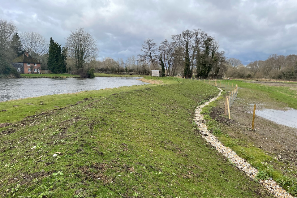
New earth embankments at Romsey Flood Alleviation Scheme, Tony Haffenden
As well as reducing flooding, there are additional ecological benefits from the scheme.
These include:
- creating 150 metres of new water vole habitat
- enhancing 150 metres of river environment by managing vegetation and improving the structure that controls water flow in the Barge Canal
- preserving some of the oldest London plane trees in the country during construction
Members of the local community were consulted throughout the scheme’s development to make sure they were happy with the design. As a result, the new bridge is a carbon-friendly design made of glass-reinforced plastic. It is covered in timber to blend in with the picturesque surroundings.
3.2.3 Partnership funding
Funding for FCERM projects is allocated in line with government partnership funding policy. The amount of funding a project is allocated depends on the damages it will avoid and the benefits it will provide.
The projects that are allocated government funding are those that:
- better protect a greater number of households
- better protect a greater number of households in deprived areas
- provide wider benefits, such as to businesses, schools, agriculture, and infrastructure
- create or enhance habitat
The amount of government funding a project is eligible for is based on the damages it will avoid and the benefits it provides. If a project is not eligible for full government funding, it will need partnership funding contributions to make up the difference. They come from those benefiting from the project, including:
- local partners
- the local community
- other organisations or businesses
Partnership funding contributions allow more communities to benefit from local FCERM measures than could be funded by central government alone.
Since April 2021, around £347m of partnership funding has been secured. Around £100m of this has been spent in the first 2 years of the programme. This is shown in table 6. We need to secure at least a further £473m partnership funding to achieve the programme by March 2027.
Table 6: Partnership funding spent between April 2021 and March 2023
| 21/22 | 22/23 | Total | |
|---|---|---|---|
| Partnership funding spent | £52m | £53m | £105m |
Case Study 2: Great Yarmouth flood defence epoch 2 project
Great Yarmouth is located on the North Norfolk coast. Over the last 15 years the area has seen several flood events, evacuations and near misses from tidal surges. During the North Sea flood of 1953 defences in the area failed resulting in 10 fatalities.
There are currently just over 10km of flood defences in Great Yarmouth. These reduce the risk of tidal flooding from the River Yare and River Bure to 4,500 homes, businesses and critical infrastructure.
The defences are of varying ages, so over the next 40 years work has been prioritised based on their condition and the risk of failure.

Sheet pile replacement at Bryant Wharf, Environment Agency
The Great Yarmouth Flood Defence Epoch 2 project is the second phase of works in the area. It will repair and refurbish 4km of flood defences.
We worked in partnership with:
- Great Yarmouth Borough Council
- Norfolk County Council
- New Anglian Local Enterprise Partnership
- Anglian Eastern RFCC
- Anglian Water
- DfE
- National Highways
- quayside owners and operators
- the Tidal Defence Business Partnership - a group of businesses representing Great Yarmouth’s business community
The project cost £42.9m. Partnership funding contributed just under half of this cost.
Work was completed in March 2023, and the project provides a wide range of benefits.
These include:
- 2,115 homes better protected
- benefits to local schools, roads, railways, a power station and the outer harbour
- supporting access to the thriving tourist area of the town centre
- extending the life of the operational quaysides which are used by offshore and renewable energy companies
3.2.4 Asset management
There are around 238,000 assets that have a flood or coastal risk management purpose in England. 162,000 of these are maintained by riparian owners, which are third parties who own the land next to the river.
64,000 of the third-party assets are in high consequence systems. This means they are located where there is a high concentration of properties. A system is where several flood defences work together to reduce risk and better protect an area.
We maintain 76,000 of the 238,000 assets in England.
Between April 2022 and March 2023 we spent over £200 million on maintaining FCERM assets.
The investment includes:
- maintenance activities such as inspecting, maintaining and operating assets
- channel maintenance
- developing technology
On average, each year we inspect over 165,000 flood risk management assets. This includes a planned annual inspection programme of 157,000 plus further inspections where needed. We inspect both our own assets and third party assets that form part of a system.
We inspect assets on a risk basis. This means we inspect the highest risk assets most frequently.
On 31 March 2023, 94.5% of our flood risk assets in high consequence systems were in the required condition. The Autumn Budget and Spending Review 2021 announced an additional £22 million each year from 2022 to 2025 for the maintenance of flood defences. This will help manage the impacts of our changing climate on flood defences.
Our long-term aim, with the appropriate level of investment, is for 98% of our high consequence assets to be at their required condition.
We publish details of planned maintenance activities in the river and coastal maintenance programme.
3.3 Public sector cooperation agreements
The FWMA 2010 requires RMAs to cooperate with each other when carrying out FCERM activities. RMAs should work together to provide flood risk maintenance and other activities.
One example of partnership working is public sector cooperation agreements (PSCAs). These allow 2 public sector bodies to set out how they will work together to achieve public tasks of mutual benefit. The benefits of partnership working are well established.
We use PSCAs for a wide variety of work including:
- routine maintenance
- small improvement works
- incident response
Table 7: summary of Environment Agency PSCAs on 31 March 2023
| Risk Management Authority | Number of PSCAs in place |
|---|---|
| Internal drainage boards | 30 |
| Lead local flood authorities | 4 |
| Navigation authorities | 3 |
| Total | 37 |
3.4 Efficiency savings
We report to government about the efficiencies achieved through our FCERM investment programme. This is so that we achieve the best possible value for the investment of government funds.
We can achieve efficiencies through:
- national initiatives that allow operational improvements
- project specific activities
Savings are achieved through:
- innovation
- value engineering
- longer-term planning and packaging of work
We aim to achieve 10% efficiencies in the current investment programme.
Between April 2022 and March 2023, we achieved £17m in efficiency savings. We have done this mainly by using different contract methods to gain greater value and risk sharing from our supply chain.
Efficiencies vary from year to year.
They depend on:
- the FCERM funding allocation for that year
- individual project completion dates
Case Study 3: Lydd Ranges Sea Defences Scheme
The Lydd Ranges Sea Defences Scheme is one of several projects that together form the Folkestone to Cliff End Strategy (FoCES). FoCES sets out our plans to manage coastal flood and erosion risk to the low-lying Romney Marsh area over the next 100 years.
The area also lies within several environmental designations. These recognise the importance of the wider Dungeness foreland and its associated wildlife habitats.
The area includes:
- Site of Special Scientific Interest (SSSI)
- Special Protection Area (SPA)
- Special Area of Conservation (SAC)
- Ramsar (important wetlands habitat)
We originally designed the project to include steel sheet pilings along a 1.1km section of the Green Wall embankment. We then carried out further site investigations. These showed that the existing bank material would provide the same standard of protection once some additional clay was used to provide stability.
This change has allowed us to maintain the connection between the sea and the brackish lagoon behind. This means the lagoon can continue to support the nesting habitat of the Schedule One protected Avocet.
The change in design saved almost £572,000. We also made significant carbon savings.
4. FCERM strategy ambition 1 - climate resilient places
This section explains how RMAs are working together to increase resilience to flooding and coastal change, both now and in the future.
4.1 Climate change
Our climate is changing, sea levels are rising, and we are experiencing more extreme weather.
We are already seeing these changes. 2022 was the warmest year on record in the UK. In July 2022 recorded temperatures exceeded 40oC for the first time in the UK.
Rainfall was below average for most of the year, with July the driest on record for England since 1935. A heatwave during July and August led to increased water demand and drought conditions in some part of the county.
Long term records show that in the UK:
- temperatures are rising
- more rainfall in winter is falling in heavy events
- sea levels are rising more rapidly than in the past
The scale of potential future flooding and coastal change is significant. One in 6 people are already at risk of flooding from rivers and the sea. The risks will only increase with rising sea levels, more frequent and severe floods and storm surges.
Two important reports were published in 2023, reflecting these risks:
- Climate Change Committee’s adapting to climate change 2023 progress report
- the Intergovernmental Panel on Climate Change (IPCC) 2023 report
These reports highlight the scale of the issue. We need to make deep and rapid reductions in greenhouse gas emissions. This is the only way we can address the scale of climate impacts now, and limit impacts associated with additional warming.
We also need to take greater adaptation action to manage the impacts we are already facing.
There are 2 main ways we can tackle climate change:
- mitigation – reducing or limiting the effects of greenhouse gases to reduce the impacts of a changing climate
- adaptation – changing lifestyles, economy, and infrastructure to adapt to the unavoidable impacts of climate change
We need to prepare for the changes that are already happening. We need to both mitigate and adapt to minimise risks from climate change.
The climate of the future depends on the actions we take now.
4.1.1 Mitigation
In May 2021 we published our road map for cutting carbon emissions and reaching net zero by 2030.
This document sets out:
- our plan to reduce our carbon emissions by at least 45%
- the sources of our emissions
- the tangible actions we will take to reduce these emissions
- our plan to offset the remaining carbon emissions
We have an action plan that supports our net zero road map. This contains 92 actions which we track and report progress on every quarter.
In 2019 our investment in FCERM projects accounted for well over half (54%) of our corporate carbon emissions. This was the equivalent of around 148,000t CO2e.
Since 2019 investment in FCERM projects has doubled. This increase comes an increased potential for more emissions. Currently we estimate that our emissions from our construction are greater than 70% of our overall carbon footprint. This is because the replacement and repair of building fabrics following flood events also result in carbon emissions.
However, our flood risk management projects also avoid using carbon. We estimate that 268,000t CO2e of carbon will be avoided through the operational life of FCERM projects completed between April 2021 and March 2023. This is through properties not flooding and livelihoods being protected.
We continue to prioritise reducing carbon during the construction of our flood risk management projects. The choices we make about the construction materials we use are very important.
For example, over 80% of our carbon emissions from construction are contained in the concrete and steel used. To reduce this, we have changed our technical requirements for suppliers. We now specify low carbon concrete by default.
Case study 4: Hexham Flood Alleviation Scheme
Hexham is a small town in Northumberland with a population of around 11,000. Ninety properties suffered from flooding during Storm Desmond in 2015. The Hexham flood alleviation scheme will provide improved protection against future flooding from the River Tyne.
Construction of the scheme started in January 2023. As part of the scheme pilots were funded by the Net Zero Carbon for Infrastructure (NZC4I) Programme. These pilots are investigating new ultra-low (non-cement based) and lower-carbon concretes.
We performed 6 trial pours to create the permanent base and walls of a new flood defence structure. We used a design-by-performance testing approach to identify the best mixes for our requirements, as these are not currently included in the concrete standards.
The new approach should result in a 70% reduction in carbon compared to standard concrete.
We will:
- monitor the site to show the long-term durability and suitability of the new concrete mixes
- use the data to show how we can use carbon solutions in future
The flood defence scheme at Hexham was completed in summer 2023.
4.1.2 Adaptation and resilience
We are planning for a 2oC global temperature increase by 2100 in our FCERM Strategy. However, it is also important that we prepare for more extreme scenarios of climate change and assess a range of climate impacts. This will make sure our approach to FCERM can adapt to a range of climate futures.
We’re doing this in both our planning advice for new developments and for the design of new FCERM projects, schemes and strategies. Our guidance reflects the latest climate science.
Guidance for RMAs on how to account for climate change in FCERM projects, schemes and strategies fits with our partnership funding and appraisal guidance.
Flood and coastal innovation programmes (FCIP)
We are working with project managers to carry out the £200 million FCIP. The programme aims to improve the resilience of places to flooding and coastal change by sharing evidence and learning between 2021 and 2027.
The programme contains 3 elements:
- 25 innovative resilience projects
- adaptation pathway plans
- coastal transition accelerator programme
Flood and coastal resilience innovation programme (FCRIP)
£150 million of the FCIP funding is being used to develop 25 projects. In March 2021, the then Secretary of State (SoS) and Minister Pow announced the 25 projects selected. These projects are led by local authorities with support from us.
Each project will show how practical innovative actions can help to improve resilience to flooding and coastal erosion. They will do this by developing, testing, and implementing resilience actions that are outside the scope of what central government usually funds.
The 25 projects include:
- projects piloting property flood resilience (PFR) to reduce the impacts of groundwater flooding
- developing nature-based solutions with rural land managers to improve resilience to floods and drought
- developing surface water flood warnings for remote communities
- creating new habitat to increase shoreline resilience and better protect local coastal economies
- trailing new and innovative financing to improve flood and coastal resilience
The programme will share evidence and learning to inform future approaches to, and investments in FCERM.
Defra are working on an evaluation of the 25 projects.
Case study 5: Stronger Shores
Stronger Shores is one of the 25 innovative resilience projects. It covers the north east coastline from Skinningrove in North Yorkshire to Lindisfarne in Northumberland.
Led by South Tyneside Council, it is making British coastlines and communities stronger in the face of flooding, erosion and climate change.
The project will use the power of nature to:
- restore ocean health
- benefit communities
- help the UK become a world-leader in climate solutions
Through Stronger Shores, experts are learning about the benefits of hidden underwater habitats.
These include:
- seagrass meadows
- kelp forests
- oyster reefs
Together, these habitats can help improve:
- water quality
- erosion
- wave impacts
- wildlife and more
Adaptation pathway plans
£8 million of the FCIP funding is being used to develop adaptation pathway plans for managing flooding and coastal change to 2100 and beyond.
The plans cover strategic locations including the:
- Thames Estuary
- Humber Estuary
- River Severn
They also include two locations in Yorkshire:
- a catchment scale project in South Yorkshire
- a community scale surface water project in West Yorkshire
We will work with partners to develop and explore:
- different resilience actions – these could help to better plan for, protect, respond to, and recover from flooding and coastal change over pathways to 2100 and beyond
- local land use and development choices – these could allow for more flood and climate resilient places
- better coordination of planning and investment cycles with infrastructure and utilities – these could unlock investment in flood resilient infrastructure and services
- integrated water level management – which could improve flood and coastal resilience whilst also enhancing water quality and the natural environment
These will help us achieve:
- the maximum benefit for people and places at the right time
- strategic objectives and measures in the FCERM Strategy
We have developed an adaptation pathway knowledge hub which contains information and tools to help RMAs develop adaptation pathways.
Coastal Transition Accelerator Programme
We will use £36 million of the FCIP funding to develop a Coastal Transition Accelerator Programme. We will trial opportunities to transition and adapt to a changing climate. This will be done in a small number of coastal areas at significant risk of coastal erosion.
We will initially focus on North Norfolk and East Riding of Yorkshire. This is because they:
- have proportionally the highest number of properties at risk from coastal erosion
- are facing the greatest challenges from erosion and loss of coastline
Both councils will work with residents, businesses and asset owners to prepare for the long term. They will also take immediate actions that will support the long-term resilience of coastal communities.
Actions could include:
- rolling back property and facilities at short term risk of coastal erosion
- improving and replacing damaged community infrastructure such as steps and ramps to the beach
- repurposing land where property has been removed for community and nature benefit
- trialling innovative moveable buildings
- working with planners and the financial sector – to develop mechanisms and tools to support future adaptation and prevent inappropriate development in places at risk
The programme will run from 2022-2027. Other coastal communities and RMAs will benefit from the lessons learnt during this this programme.
4.2 Coastal change
The National Coastal Erosion Risk Map (NCERM) shows that about 2,000 properties are at risk of being lost to coastal erosion by 2060. This assumes all current shoreline management plan (SMP) approaches and actions are carried out.
We are currently updating our national coastal erosion predictions.
During 2022 to 2023 we have:
- completed Phase 1 of the NCERM2 project – including updating methods so that they reflect research and include climate change in our predictions of erosion risk
- worked with coastal monitoring partners to account for the latest evidence on coastal processes and how the coast is changing
- begun the first round of data checking with local authorities
Coast protection authorities (CPAs) lead on coastal erosion management. They have permissive powers, which allow them to carry out FCERM works.
Some CPAs in England have used NCERM to develop local planning mechanisms. These include coastal change management area (CCMAs).
These mechanisms:
- ensure new development takes account of the changing coast
- support the transition of communities and infrastructure away from areas at risk of coastal erosion
4.2.1 Shoreline management plans
SMPs set out the local approach to coastal adaptation, investment, and spatial planning into the next century. They identify the most sustainable management approach for each stretch of coastline in England.
The management approaches cover the:
- short-term (0 to 20 years)
- medium term (20 to 50 years)
- long-term (50 to 100 years)
CPAs and other important stakeholders have led the development of SMPs. This was done in 7 regional coastal groups across England, producing 20 SMPs.
We are working with coastal authorities to update the SMPs developed between 2006 and 2012. We are coordinating this work with support from the coastal groups.
This work will make sure that SMPs are up to date and use the best available evidence in their recommendations. This will support planning and investment at the coast into the next century.
Throughout 2022 to 2023 we have worked with the coastal groups to update the action plans. These will help support the implementation of SMPs.
We are developing an online SMP Explorer. This platform will make SMPs and their associated action plans easier to update. They will also be more accessible to coastal managers and local planners.
The final version of SMP Explorer will be launched in Winter 2023/24.
4.2.2 Coastal habitats
RMAs look for opportunities to incorporate nature-based solutions when planning and constructing new FCERM projects that create or enhance coastal habitats. They do this through making space for nature or incorporating features that enable habitats to form.
FCERM projects can also cause loss of valuable coastal habitat. We must compensate for this loss when we build and maintain FCERM assets.
This includes:
- any lost habitats
- a loss in the quality of habitats
Most losses happen due to coastal squeeze. This is where flood and coastal erosion defences prevent the natural landward migration of intertidal habitats. We normally compensate for this loss by creating and restoring habitat as part of the Habitat Compensation and Restoration Programme (HCRP). The HCRP covers both freshwater and intertidal habitats.
Habitat restoration may involve improving existing habitats and the creation of new habitat. This can link, enhance, extend and improve the resilience of the protected site network.
Overall, the HCRP has successfully kept pace with losses at internationally protected sites. These are sites identified within the SMPs and FCERM strategies in most parts of England.
As of March 2023, the HCRP has created:
- 1,601 ha of intertidal habitat
- 468 ha of freshwater grazing marsh
- 292 ha of other coastal habitats
4.2.3 Inter-tidal saltmarsh and mudflats
Intertidal habitat includes saltmarsh and mudflats. Our knowledge of saltmarsh restoration and the benefits that this brings has improved significantly over time.
Saltmarshes can:
- store carbon
- filter out excess nutrients
- provide other social and environmental benefits
We have created over 1,600 hectares of intertidal habitat since the early 2000s. Despite this progress, we expect to continue to lose coastal habitat because of sea level rise over time.
Case study 6: Lower Otter restoration project
The Lower Otter restoration project is in Budleigh Salterton, East Devon. It is a flagship climate adaptation and intertidal habitat restoration project. The project uses nature-based adaptation in the Otter Valley to benefit communities and the environment.
The Lower Otter project is the English part of a cross-border initiative with France called promoting adaptation to changing coasts (PACCo).
The project was made possible through a combination of UK Government and EU funding.
We led the project, and worked in partnership with:
- East Devon Pebblebed Heaths Conservation Trust
- Clinton Devon Estates
We have reconnected the River Otter with its historic floodplain and recreated 55 hectares of mudflat and saltmarsh.
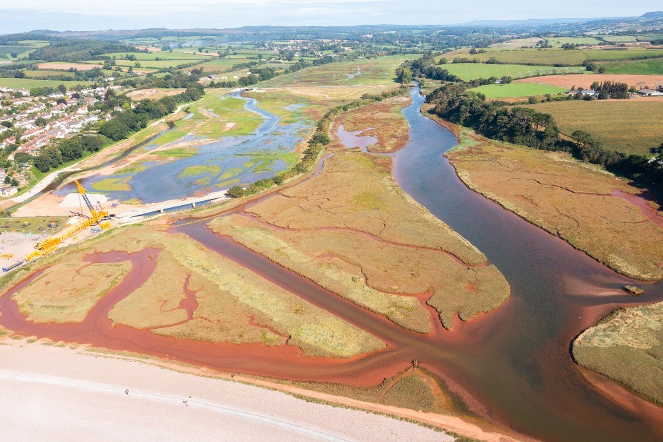
Lower Otter restoration project aerial photo showing project extent, KOR communications
4.2.4 Other coastal habitats
Other protected habitats around the coast also experience pressure from FCERM activity.
These include:
- saline lagoons and vegetated shingle
- freshwater habitats such as reed bed and coastal grazing marsh
We have created 760 hectares of these habitats since the early 2000s. These have compensated for losses associated with coastal erosion and coastal change. These are mainly reed bed and grazing marsh situated on the east and south-east coast. We need to continue to create these habitats as there are likely to be losses from future projects.
4.3 Natural flood management
Nature based solutions have an important contribution to play in achieving climate resilient places.
NFM describes interventions that reduce flood risk by using natural techniques. NFM can manage flood and coastal erosion risk by protecting, restoring and emulating the natural processes of:
- catchments
- rivers
- floodplains
- coasts
NFM also provides a range of wider benefits, including:
- increasing and improving habitats and biodiversity
- increasing water quality
- increasing availability of drinking water
- improving health and wellbeing
There are 14 different NFM measures described in the working with natural processes evidence directory that was published in 2017.
These measures include:
- river and floodplain restoration
- leaky barriers
- offline storage areas
- targeted woodland planting through to soil and land management
We can better manage flood risk for communities by complementing nature-based solutions and engineered flood and coastal defences.
4.3.1 NFM pilot programme
The 2015 to 2021 FCERM investment programme included the use of NFM through our £15m NFM programme. The programme was made up of 60 pilots across England. It demonstrates the important role nature-based projects can have in helping to slow the flow and store flood waters.
Together, the pilots:
- slowed and stored water upstream of 15,000 homes in areas at risk of flooding – this is equivalent to 1.6 million cubic metres
- created or improved 610 kilometres of rivers
- created or improved 4,000 hectares of habitat
- planted 100 hectares of woodland
Our FCERM Strategy will help achieve the aims and ambitions of the Environmental Improvement Plan (EIP) 2023 by embracing nature-based solutions, including NFM. The EIP 2023 is a recent revision to the 25 Year Environment Plan.
4.3.2 Mainstream the use of natural flood management
We published our NFM evaluation report in December 2022. This includes lessons learnt from the NFM pilot programme. We are using these lessons to introduce measures that mainstream the use of NFM in our FCERM investment programme.
Government’s FCERM policy statement has a commitment to double the number of NFM projects achieved to 260 by 2027. In the first 2 years of the programme, 52 NFM projects have had their business case approved.
We are carrying out a range of actions to continue to expand and mainstream NFM measures.
These include:
- updating our evidence directory to improve the link between NFM and flood risk reduction and other benefits
- training RMAs, land management advisors and our staff on NFM methods
- creating tools to share knowledge and help to mainstream the use of NFM amongst flood risk practitioners
- developing new ways to estimate the flood risk reduction from NFM measures and to quantify the economic benefits
4.4 Improving the environment
We work with other RMAs to look for opportunities to create and improve habitat as part of our FCERM work. We also form partnerships with groups such as wildlife and rivers trusts. Between April 2021 and March 2023 we have carried out many environmental improvements.
These include:
- enhancing 37km of rivers
- enhancing or creating over 1,200ha of habitat
Examples of these improvements include:
- removing or modifying weirs to make it easier for fish to migrate upstream
- implementing nature-based flood solutions that create and/or restore habitat and reduce flood risk downstream
4.5 Strategic planning: flood risk management plans
Flood risk management plans (FRMPs) set out how organisations, stakeholders and communities will work together to manage flood risk in England. They cover flooding from rivers, sea and surface water.
In December 2022 we published FRMPs for England covering 2021 to 2027.
FRMPs make an important contribution towards helping to achieve the ambitions of the FCERM Strategy.
We worked closely with LLFAs and other partners to produce these plans. We carried out a public consultation which resulted in around 2,500 actions to help manage flood risk between 2021-2027.
The published plans include:
FRMPs: you said, we did shows how we used consultation feedback to update the plans. This included:
- the importance of partnerships to achieve actions
- the need to strengthen a catchment approach - so that we work with and value the natural environment and the places we live and work in
These plans will help FCERM partners to:
- identify actions that will reduce the likelihood and consequences of flooding
- carry out existing flood programmes
- improve resilience of people and places to plan for, respond to, and recover from flooding and coastal change
- plan and adapt to a changing climate through developing longer-term, adaptive approaches
- work in partnership to achieve wider resilience measures, such as nature-based solutions
This is the second time we have prepared flood risk management plans. The latest versions include several improvements:
- aligning the plan objectives and actions with the FCERM Strategy
- creating an online Flood Plan Explorer that shows what measures (actions) are planned at a national and local scale
We are now working with partners and communities to carry out the plans and actions.
4.6 Agriculture and land management
Farming in Britain is undergoing significant change. The Agricultural Transition Plan sets out government’s ambitions for new financial incentives. It also considers the importance of food security and enhancing our natural environment.
The FCERM Strategy recognises the importance of agriculture and land management. It makes it clear farmers have a role in mitigating flood risk whilst increasing the resilience of their own farm.
Between April 2022 and March 2023 we better protected around 120,000 hectares of Grade 1, 2 and 3 agricultural land from flooding. This work was carried out through the FCERM investment programme.
4.6.1 Environmental land management schemes
We are working with Defra on the design and launch of 3 environmental land management schemes (ELMS). This work will help to maximise the benefits for FCERM.
The 3 ELMS are:
Sustainable Farming Incentive
The first round of the SFI started in June 2022.
The SFI will help farmers manage land in a way that improves food production and is more environmentally sustainable. Payments will be available for improving soil heath and minimising bare ground.
Countryside Stewardship
Defra decided to evolve the current Countryside Stewardship offer rather than launch a new Local Nature Recovery (LNR) scheme. This was announced in autumn 2022. The changes will not compromise the proposed environmental ambition.
In January 2023, Defra published the ELM update paper. This describes how farmers and land managers will be paid for increasing resilience to flooding and drought. They will do this through nature-based solutions such as NFM and restoring coastal habitats.
Countryside Stewardship will include extra incentives for land managers to join up across local areas. This will result in bigger and better outcomes.
New and updated options will be available for land managers from 2024.
Landscape Recovery
Landscape Recovery represents a new approach to supporting long-term, significant habitat restoration and land use change. This will be essential to achieve government’s environmental ambitions.
The first round of Landscape Recovery took place in 2022. Twenty-two projects were selected for funding.
The first round focussed on 2 themes:
- restoring England’s streams and rivers – improving water quality, biodiversity and adapting to climate change
- recovering and restoring England’s threatened native species
Together, the projects cover over 40,000 hectares.
They aim to:
- reduce the risk of flooding
- restore nearly 700km of rivers
- protect and provide habitat for at least 263 species
We are administering the 11 river and stream restoration projects. These projects now have grant agreements in place for the two-year project development phase. Teams will use this phase to plan how to carry out and implement their projects.
Landscape Recovery round 2 opened for applications in spring and summer 2023. £15 million is available to fund up to 25 projects.
This round will achieve a range of outcomes, with a focus on:
- net zero
- protected sites
- habitat creation such as rivers and wetlands, peatland and coastal habitat
We will consider a project’s contribution to increased resilience to flooding and coastal erosion within the scoring criteria.
4.6.2 Catchment Sensitive Farming (CSF)
The Catchment Sensitive Farming (CSF) programme is a partnership between us, Natural England and Defra. It was expanded in April 2022 to include the provision of advice for NFM practices.
We are working with Natural England to provide the advice and guidance on NFM. This advice includes both established and expanded CSF practices, such as:
- soil management to improve infiltration
- buffer strips to slow flow
- run-off attenuation features to store and slowly release water
Since April 2022, CSF advisors have worked with at least one NFM project in each River Basin District. This has linked the NFM workstream with practices advised (one-to-one) more than 1,000 times at more than 500 holdings.
Case study 7: Alconbury Brook NFM Project
Alconbury Brook is an agricultural catchment in Cambridgeshire.
We used the CSF approach to identify and provide NFM measures to reduce flood risk and improve water quality.
CSF advisors hosted several successful workshops and farm visits to introduce the project and encourage the uptake of NFM measures.
They also provided advice directly to farmers. This covered:
- the most appropriate locations to install measures
- the types of measures which would be most suitable
- guidance on funding
Our collaborative approach was very effective. Working with farmers through CSF increased the number of people interested in the project and the uptake of measures.
Overall, the project successfully provided a diverse range of measures across the catchment.
These included:
- 22 leaky woody structures
- 12 check dams
- 3 enhanced ponds
- 1 new pond
- 3 sediment traps
- 2 livestock crossings
- tree and hedge planting
Alconbury Brook natural flood management project new pond, Mhari Barnes
5. Ambition 2 – today’s growth and infrastructure resilient in tomorrow’s climate
This ambition is about making the right investment and planning decisions to secure sustainable growth and environmental improvements. It also supports infrastructure resilient to flooding and coastal change.
5.1 Promoting safe development resilient to flooding and coastal change
Our Long Term Investment Scenarios predict that the number of homes in the floodplain will almost double over the next 50 years.
Climate change will also increase the:
- size of flood risk areas
- frequency and severity of flooding
- complexity of the flood risk issues needing to be tackled
Spatial planning helps us minimise the flood damages that these trends could cause. The NPPF makes it clear that we should avoid inappropriate development in areas at risk of flooding.
Development that takes place in flood risk areas should:
- be designed to be safe throughout its lifetime
- not increase flood risk elsewhere
Development design should be flood resistant and resilient. This will minimise flood damage and speed up recovery in the event of flooding.
We have an important role as a statutory planning advisor to local planning authorities (LPAs). We support sustainable development by engaging with, and advising, developers and planners. By doing this, we help to support sustainable growth in the right places.
Investing in flood risk planning advice makes good economic sense. For every £1 we spend providing advice, around £12 of future flood damages are avoided.
We comment on development proposals:
- in areas that are currently at medium or high risk of flooding from rivers and the sea
- in areas with critical drainage problems
- within 20 metres of a main river
We are not a statutory consultee:
- on development in flood zone 1 which we expect to be at risk of flooding from rivers or the sea in the future
- when proposed development could be at risk from other sources of flooding such as ground or surface water
LLFAs are a statutory consultee on major development with surface water drainage.
We respond to approximately 9,000 planning applications each year. We provide detailed flood risk advice for around 6,000 planning applications. Our flood risk planning advice helps to avoid around 40,000 homes from being built each year in an unsafe way or location.
Between April 2021 and March 2022 7% of new homes were built in Flood Zone 3. Properties in this zone are at 1% or greater probability of flooding from rivers or 0.5% or greater probability of flooding from the sea.
This is unchanged from the previous year. However, it is a reduction from the 9% recorded in 2019/20 and the 11% recorded in 2016/17.
The Department of Levelling Up, Housing and Communities (DLUHC) will publish figures for 2022/23 later this year. You will be able to see them on the land use change statistics page on GOV.UK.
Between April 2022 and March 2023:
- 96.3% of all planning decisions were in line with our advice on flood risk
- 99.3% of new homes proposed in planning applications complied with our advice on flood risk
- we are aware of planning permissions for 267 homes that were granted against our advice on flood risk
We record a sample of planning application outcomes. This:
- gives us an overview of how effective our advice is
- helps us focus our efforts on positively influencing development proposals
We recorded decisions for 1,717 planning applications where we lodged flood risk objections. These cases totalled 37,068 homes overall. Between 1 April 2016 and 31 March 2023, we recorded the LPA’s final decision for around 60% of the applications we objected to on flood risk grounds.
We publish a list of all applications where we’ve lodged initial objections on flood risk grounds. Often, the issues are resolved before a final decision is made.
Table 8: planning applications reviewed by the Environment Agency between 1 April 2022 to 31 March 2023
| Type of Action | Total |
|---|---|
| Planning applications responded to | 9,198 |
| Planning applications which required detailed flood risk advice | 6,060 |
| Number of planning decisions recorded that related to flood risk objections | 1,717 |
| Number of homes granted planning permission contrary to our flood risk advice | 267 |
| Number of planning decisions recorded in line with our advice | 1,653 |
| Number of planning decisions made contrary to our flood risk advice | 64 |
| % of planning applications determined in line with our advice | 96.3% |
| % of residential properties in planning applications in line with our advice | 99.3% |
The SoS for DLUHC has the power to call in (take over) planning applications.
LPAs must refer certain planning applications to the SoS if we have objected on flood risk grounds. LPAs are responsible for identifying relevant planning applications and for following the statutory process set out in The Town and Country Planning Direction 2021.
Between April 2022 and March 2023, 5 planning applications were referred to the SoS. The SoS called-in one application which was subsequently withdrawn by the applicant.
We withdrew our objection for 2 of the cases. The SoS decided not to intervene in the remaining 2 cases. These were sent back to the LPA to decide.
You can read more information on called-in cases and decisions.
5.1.1 Planning policy, guidance and research
This year, we worked with the Town and Country Planning Association (TCPA) to provide training webinars for local planning authorities. These explained the summer 2022 update to government’s planning practice guidance on flood risk and coastal change. Updating this guidance was a key recommendation of government’s review of policy for development in areas at flood risk.
We also worked with the TCPA to carry out a local authority skills survey. This survey helped us improve our understanding of local authority training needs.
We used the findings from the survey to design and provide pilot training sessions. These sessions tested the training materials we developed and asked for feedback on their effectiveness. We will now update these materials based on this feedback and explore how to reach a larger audience.
With our input, the TCPA also created:
- the climate crisis – a guide for local authorities on planning for climate change
- building a safer future – a guide for communities on the planning system and flood risk
- climate guide case studies – a case study hub that showcases examples and best practice
This year we were a member of an advisory group formed by Defra. The purpose of the group was to inform Defra’s review for implementation of Schedule 3 to the FWMA. We continue to work closely with Defra ahead of the expected implementation during 2024.
We also worked with Susdrain on the development of sustainable drainage systems (SuDS) and the implementation of Schedule 3. Susdrain is a community that provides a range of resources for those involved in SuDS.
These resources include:
- tools and guidance – for example the Benefits Estimation Tool (B£ST) and the SuDS Manual
- training
- case studies
Susdrain also celebrate successes through the SuDS Awards.
5.2 Property Flood Resilience
Just over 300 properties were better protected by PFR measures between April 2022 and March 2023.
We have worked with the Chartered Institution of Water and Environmental Management (CIWEM) to develop PFR training. This training will help partners to follow the PFR Code of Practice.
The training is targeted at 2 audiences:
- RMA staff involved in managing PFR projects
- surveyors, suppliers and installers involved in carrying out PFR projects
Foundation training is also available. This introduces attendees to the elements of PFR. Users will need to complete this before starting the technical training, which we are currently developing.
5.3 Reservoir safety
We regulate large, raised reservoirs (LRRs) in England. In April 2023, there were 2,124 registered LRRs.
This regulation is a requirement of the Reservoirs Act 1975, which aims to ensure that dams and reservoirs are safe. Responsibility for the safety of reservoirs lies with their undertakers who are the owners or operators of the reservoir.
As the enforcement authority, we must make sure undertakers follow the legal safety requirements. We report on our enforcement action in our biennial report, which we will now publish annually 2023 onwards.
Owners and operators must report incidents at LRRs. This is a requirement of the Act and Regulation 14 of Statutory Instrument 2013 No. 1677. Since 2013, an average of 8 incidents have been reported each year.
Five incidents were reported to us between April 2022 and March 2023, a decrease in 11 from last year.
One was a Level 2 (serious) incident. This is where emergency measures are required. The reservoir undertaker managed the incident and we did not need to get involved.
Four level 3 incidents occurred, which is when the undertaker takes precautionary measures. Reservoir owners have 12 months following an incident to provide a full and comprehensive post incident report.
You can read about these incidents in our post-incident reporting for reservoirs annual report.
By December 2022, all operational LRRs held a certified onsite flood plan. A ministerial direction in April 2021 gave undertakers 12 months to develop the plans and appoint a panel engineer to certify them. We continue to monitor new reservoirs to ensure they have certified plans.
Government accepted all of Professor David Balmforth’s independent reservoir safety review report recommendations. We are working with Defra on a reservoir safety reform programme to carry out these recommendations.
In June 2022 we published new guides for reservoir engineers for the inspection and supervision of reservoirs. You can read more about the reservoir safety reform programme update.
Case Study 7: Ouse Washes reservoir safety works
The Ouse Washes flood storage reservoir is a 90 million m3 flood storage reservoir located in Cambridgeshire.
It is:
- approximately 19 miles long and up to 0.5 miles wide
- crossed by 3 roads that are underwater in a flood
Norfolk County Council highways team close the road when the Washes flood and the water level on the Welney Wash road reaches a certain level. If water rises above this level we have to build a temporary flood barrier across the road. This stops the water spilling into Welney village.
We started works in 2017 on the reservoir, following a safety inspection. This work included:
- raising the reservoir banks
- building a new permanent demountable barrier across Welney Wash Road
- extending a retaining wall at Sutton Gault
- building a new wall at Welches Dam Pumping Station
- decommissioning the Earith Black Sluice culvert
We completed the work in 2022. It cost a total of £40 million. Overall, the project better protects over 2,000 properties. Those next to the bank are predicted to be safe in a 0.01% probability event.
5.4 Surface water management action plan
Surface water flooding is the most widespread form of flooding in England, affecting around 3.4 million properties. We know that this risk will increase over time due to climate change and population growth unless we act.
LLFAs are responsible for managing surface water. We have a legal supervision over all sources of flooding, which includes from surface water. This ‘strategic overview’ role is distinct from the day-to-day operational role we have for managing flood risk from main rivers and the sea.
The government’s FCERM policy statement and our FCERM Strategy and the Roadmap set the future direction for managing surface water flood risk.
During 2022-2023, we have continued to progress:
- actions from the government’s Surface Water Management Action Plan
- recommendations from the independent Jenkins’ review
This includes working with the regional flood and coastal committees (RFCCs) to:
- review the number and geographical distribution of water and sewerage company representatives on RFCCs
- gather information on what local partnerships exist in RFCCs which are, or can have, a positive influence on surface water management
This work builds on the progress already outlined in the government’s update report from July 2021.
We have also completed a commitment in the Roadmap to work with partners to help with surface water management.
We have worked with:
- Water UK
- Ofwat
- other RMAs
This work has helped develop draft drainage and wastewater management plans (DWMPs). These plans should help to improve resilience to surface water and drainage flood risk.
5.5 Flood risk activities – environmental permitting
We regulate work on or near main rivers using environmental permits.
Our aim is to ensure our customer’s journey is positive and they get their permits in a timely and organised manner. Between April 2022 and March 2023, we issued 1,698 bespoke permits. There were also 1,151 registered exemptions.
We continue to monitor and take enforcement action against unauthorised activity in rivers and floodplains. This can include illegal ground filling in the floodplain or taking material from within the river without the necessary permissions.
We continue to improve our service, to ensure our customers and partners receive value for money. During this reporting period we reviewed the current demand for different types of activities within our rivers.
For example, we are seeing an increase in work relating to NFM and river restorations. We need to make sure our regulatory approaches are fit for purpose for this type of activity.
We continue to invest in digital and IT solutions to improve the service we provide to customers.
Case Study 8: River Lugg prosecution
The River Lugg in Herefordshire is a designated SSSI. At least 121 river plant species live in the river and provide habitat for invertebrates, fish and birds. These include otters, kingfishers and salmon.
In 2020, landowner John Price destroyed much of this habitat over a 1.5km section of the river. He used heavy machinery including bulldozers and excavators to dredge and reprofile the river. This was unconsented work in breach of several regulations. Mr Price persisted with the works despite being issued with a Stop Notice.
In March 2022, we worked with Natural England to launch joint legal action against the landowner. This was done following an in-depth investigation into ecological harm carried out.
This legal action was successful. John Price was sentenced to 12 months in prison, although this was reduced to 10 months following appeal. He was also ordered to pay prosecution costs of £600,000 and disqualified from being a director of a limited company for 3 years. In addition, a Restoration Order under the Wildlife and Countryside Act 1981 was imposed requiring Mr Price to carry out several actions to restore the river.
5.6 Water companies’ contribution to reducing risk
Between April 2022 and March 2023 water companies have:
- worked with partners to reduce flood risk to communities
- enhanced the resilience of their networks and services to flooding
- produced and consulted on their draft drainage and wastewater management plans (DWMPs)
- responded to flood incidents and engaged in multi-agency exercises
- continued to innovate and share good practice
Between April 2022 and March 2023, water companies invested:
- £117.7 million to reduce the risk of sewer flooding to properties
- £153.8 million to maintain the public sewer system to prevent blockages and flooding
- £9.6 million in property-level protection and mitigation measures to reduce the likelihood of customers’ homes experiencing sewer flooding
We published a joint approach with Ofwat to support water companies in their partnership working. It sets out how water companies should consider flood and coastal resilience alongside their statutory roles and duties.
Water companies are working with other stakeholders to manage water in a more integrated way. This will help them:
- improve the resilience of services and communities to all sources of flood and coastal risk
- enhance the natural environment
There have been some good examples of partnership and integrated working this year. For example:
- Severn Trent Water’s Mansfield green recovery initiative – using sustainable drainage systems and nature-based solutions to make the town more flood resilient and improve the environment
- Southern Water’s pathfinder project – exploring solutions to flooding and pollution issues on the Isle of Wight by keeping surface water out of the sewer network
Other innovations and collaborative working this year include:
- Yorkshire Water and United Utilities testing new approaches for water supply reservoirs and flood risk management – this will help decide which water supply reservoirs can provide flood risk benefits and ensure integrated decision-making leads to many benefits
- water companies working with us and government – to identify sites across the government estate (for example hospitals and prisons) where sustainable drainage systems could provide environmental and wider benefits
6. Ambition 3 - a nation ready to respond and adapt to flooding and coastal change
This ambition is about ensuring local people understand:
- their risk of flooding and coastal change
- their responsibilities
- how to take action
6.1 Skills and capacity in LLFAs
Other RMAs are responsible for projects that better protect around half the properties in our £5.2 billion FCERM investment programme. It is important that they (and the suppliers they work with) have the capacity and capability to lead the projects that achieve this ambition.
We are supporting other RMAs by:
- streamlining the FCERM project process
- improving access to guidance, tools and training
This year, we launched supporting flood and coast projects. This is an improved SharePoint online site. You may need to email admin_FCERMprojectsupport@environment-agency.gov.uk to request access.
Its aim is to help RMAs and other partners develop projects that improve resilience to flooding and coastal change. This will help achieve our National FCERM Strategy ambitions.
This site includes everything project teams need to know and is tailored to different levels of capability from beginner to expert.
It includes:
- tools
- learning resources
- case studies
- links to guidance on GOV.UK
- a community space where users can seek support from peers and national experts
We are also improving processes and guidance for the smaller projects that make up most of our capital investment programme. These changes will be shared through supporting flood and coast projects in the Summer of 2023.
6.2 Using digital technology to warn and inform
The way we use digital technology continues to evolve. We have developed and improved our services in several ways, including:
- how we warn the public about expected flooding through our flood warning service
- our flood risk information services on GOV.UK
- making our flood information available as open data
6.2.1 Flood warning service
We have:
- continued to improve our flood warning service based on user feedback.
- made extensive changes to the public facing sign-up for flood warnings service.
These include:
- improvements to the layout, usability and content of the service
- making it more intuitive to use
- giving users control over all aspects of their registration
In future we will:
- make service-wide accessibility improvements
- continue to improve usability based on user feedback
We changed the service we provide to our “opt out” customers with mobile numbers. This is now a text message rather than an automated phone call (although we still use an automated call for severe flood warnings).
We are currently tendering for a supplier to build the next flood warning system ready for launch by the end of 2025. We are working with internal and external users and a commercial supplier to improve the way we prepare and communicate flood warnings.
This will result in a new, 24 hours a day, all year round, flood warning capability that is:
- resilient
- fit for the future
- inspires action against flooding
We supported the Cabinet Office and wider government on the launch of Emergency Alerts on 19 March 2023. The technology allows us to broadcast a message to a defined area. This means any compatible device in or entering that area immediately receives the emergency message.
Emergency Alerts do not need any personal information (for example telephone number, identity or location). This means they are one-way and do not provide any information on the recipients’ location or whether they have received an alert.
6.2.2 Flood warnings - number issued and properties registered
Being prepared helps reduce the impacts of flooding and enables faster recovery. We encourage people to register for our free flood warning service. Alerts and warnings enable the public to take action to protect themselves and their possessions.
Our flood warning service covers:
- flooding from rivers and the sea
- some properties in areas at risk of groundwater flooding
The flood warning service does not cover surface water flooding. This is because it can be difficult to predict:
- where sudden rainstorms will occur
- their intensity and duration
- the effect the rain has on the ground
Our surface water management action plan includes an action to work with the Met Office to develop short range rapid forecasting. This would cover the type of rainfall that causes surface water flooding.
As of March 2023, there were over 1.54 million properties registered to receive free flood warnings. This includes phone numbers registered in areas at risk from flooding that are automatically opted-in.
6.2.3 Flood alerts, flood warnings and severe flood warnings issued
Between April 2022 to March 2023, we issued:
- 2,473 flood alerts
- 547 flood warnings
- 0 severe flood warnings
Find out what to do in a flood and what the different types of warnings mean.
Table 9: number of flood alerts, flood warnings and severe flood warnings for the period 1 April 2022 to 31 March 2023
| Month and Year | Number of Flood Alerts | Number of Flood Warnings | Number of Severe Flood Warnings |
|---|---|---|---|
| April 2022 | 9 | 0 | 0 |
| May 2022 | 3 | 1 | 0 |
| June 2022 | 8 | 0 | 0 |
| July 2022 | 5 | 0 | 0 |
| August 2022 | 70 | 2 | 0 |
| September 2022 | 117 | 15 | 0 |
| October 2022 | 194 | 16 | 0 |
| November 2022 | 595 | 94 | 0 |
| December 2022 | 364 | 69 | 0 |
| January 2023 | 562 | 247 | 0 |
| February 2023 | 115 | 18 | 0 |
| March 2023 | 431 | 85 | 0 |
Table 10: comparison of flood alerts, flood warnings and severe flood warnings issued 1 April to 31 March each year between 2018 and 2023
| Years | Number of flood alerts | Number of flood warnings | Number of severe flood warnings |
|---|---|---|---|
| 2018 to 2019 | 1,844 | 366 | 0 |
| 2019 to 2020 | 4,834 | 2,455 | 27 |
| 2020 to 2021 | 2,843 | 1,176 | 10 |
| 2021 to 2022 | 2,129 | 653 | 14 |
| 2022 to 2023 | 2,473 | 547 | 0 |
6.2.4 Messages sent
Between April 2022 and March 2023 we sent over 4.7 million messages to the public, partners and the media. These messages informed them of flooding in their area and the flood warning service they can receive.
This includes messages sent via:
- text
- automated telephone call.
Table 11: number of messages sent for the period 1 April 2022 to 31 March 2023
| Month and year | Total number of messages sent and attempts to send |
|---|---|
| April 2022 | 72,101 |
| May 2022 | 55,072 |
| June 2022 | 84,567 |
| July 2022 | 60,007 |
| August 2022 | 172,556 |
| September 2022 | 301,085 |
| October 2022 | 317,240 |
| November 2022 | 944,683 |
| December 2022 | 599,398 |
| January 2023 | 1,062,150 |
| February 2023 | 265,004 |
| March 2023 | 807,184 |
Table 12: comparison of messages sent 1 April to 31 March each year between 2018 and 2023
| Year | Number of messages sent |
|---|---|
| 2018 to 2019 | 2,987,759 |
| 2019 to 2020 | 10,713,780 |
| 2020 to 2021 | 6,882,140 |
| 2021 to 2022 | 4,935,396 |
| 2022 to 2023 | 4,741,047 |
6.3 Flood risk information service
Between April 2022 and March 2023, we continued to improve the 3 main flood risk information services on GOV.UK.
These are:
- Check for flooding (replacing the Flood Information Service in October 2021)
- Check your long term flood risk for an area in England
- Flood map for planning
Table 13: Flood information / Check for flooding service user totals each year from 1 January to 31 December between 2018 and 2022
| Year | Total number of users | Total page views |
|---|---|---|
| 2018 | 1.6 million | 18 million |
| 2019 | 5.0 million | 48 million |
| 2020 | 6.2 million | 65 million |
| 2021 | 3.2 million | 37.3 million |
| 2022 | 794,000 | 8.7 million |
In 2022, we introduced a new cookie policy for check for flooding. This means figures can only be collected for users who have accepted the use of analytics cookies on the service. We estimate that only around a 25 to 30% of users accept cookies.
6.3.1 Improving access to flood services
We are currently running a project called improving access to flood services. The aim of this project is to make sure users can access our critical public facing flood services easily.
We want to:
- improve the connections between our services
- help users quickly find relevant content
We aim to guide our users across our services to ensure that they understand their overall flood risk. This will let users find what they need to adequately protect themselves and their homes from the threat of flooding.
We are focusing on the most visited GOV.UK pages. We will update and improve the content and reduce duplication between pages.
We are also aiming to reach users where they go for their everyday lives, rather than expecting them to come to our services. This will help more people understand their flood risk and be more resilient. We will increase the presence of our flood digital services across the country to significantly increase their reach.
6.4 FCERM Research and Development Programme
The FCERM Research and Development Programme is run by:
- Defra
- the Environment Agency
- Welsh Government
- Natural Resources Wales
The programme is divided into 3 themes. These are:
- policy, strategy and investment
- asset management
- incident management and modelling
The programme provides research, information, tools and techniques. It ensures we use high quality science to inform policy and practice.
As well as running our own projects, our researchers work in partnership with industry, academia and other agencies. The FCERM research and development programme has a dedicated webpage on GOV.UK
6.4.1 Research publication highlights
Reservoir spillway design, examination and failure mechanisms
In June 2022, we published 3 technical guides to improve the design, inspection and management of reservoir spillways. These examine spillway design and the mechanisms that could lead to spillway failure. The guides provide best practice guidance to improve safety at reservoirs in England and Wales.
They are for:
- reservoir managers
- undertakers
- supervising engineers
- inspecting engineers
Measuring resilience to flooding and coastal change
In November 2022, we published the findings of our measuring resilience to flooding and coastal change research project.
This project:
- identified measurements which could be used to track changes in resilience to flooding and coastal erosion locally and nationally in England
- demonstrates progress against the FCERM Strategy
We also published the challenges of using social resilience indicators - from armchair thinking to research and policy. This includes 2 case studies exploring practical issues in estimating community resilience at this level in England.
Working together to adapt to a changing climate - flood and coast
In January 2023, we published working together to adapt to a changing climate. This project explores how authorities can work with communities on future planning and decision-making. This will help reduce flood and coastal erosion risk in the face of climate change.
The findings will be useful for engagement staff in RMAs. They will also help anyone who wants to know how authorities, communities and partners can:
- exchange views
- increase understanding
- plan together
The publication was followed by a project launch in February and a set of 3 workshops providing more detail on the engagement tools that had been created.
(https://www.youtube.com/watch?v=HcEndrj6hdE)
Climate change and fluvial flood peaks
In March 2023, we published updates to river flooding projections. These build on earlier work around regionalised impacts of climate change on flood flows.
We have reduced some uncertainty in the original work. We’ve done this by combining information on catchment sensitivity to climate change with a national scale model that represents all catchments.
We carried out this work jointly with Natural Resources Wales and the Scottish Environmental Protection Agency (SEPA). This means the work is consistent across Great Britain.
Identifying and managing risks arising from defence structure transitions
In March, we also published tools and guidance that provide consistency in the risk assessment guidance associated with flood defence asset transitions. Transitions are the connection points between flood defences and other infrastructure.
The original guidance on visual asset inspection did not explicitly account for the potential effects of transitions on defence performance. This work will help RMAs prioritise improvements to reduce flood risk.
6.5 International learning
We continue to have strong links and good relationships with several international organisations and agencies:
These include the:
- Dutch flood agency, Rijkswaterstaat
- Dutch regional water authority, Hoogheemraadschap Hollands Noorderkwartier
- United States Army Corps of Engineers (USACE)
- Australian Bureau of Meteorology
We have worked with these organisations for many years. We exchange knowledge and technical expertise in flood and coastal risk management. The topics and issues covered include:
- flood assets
- nature based solutions
- coastal processes
- incident management and response
- sustainability
We have recently finished some important projects and started several new initiatives.
We continue to share knowledge and best practice on flood and coastal risk through events and conferences. We were at the World Ocean Summit in Lisbon in February 2022.
6.5.1 Polder 2Cs project
We have been part of the Polder 2Cs project, which started in January 2020 and concluded in March 2023. The project carried out research activities, field trips, exercises and tests on decommissioned flood defence embankments on the Dutch-Belgian border. You can read more about the Polder 2Cs project results.
6.5.2 EU Interreg Promoting Adaptation to Changing Costs (PACCo) project
The EU Interreg Promoting Adaptation to Changing Costs (PACCo) project finished in March 2023. This work will leave a lasting legacy for coastal communities. It has also led to the start of the EU Interreg MANABAS Coast project.
This work will develop a framework, tools and guidelines for the use and mainstreaming of nature-based solutions in the North Sea Region. We were observers at the start-up meeting in the Hague.
7. Looking ahead
This section lists some of the activities that we, government and other RMAs will be carrying out beyond April 2023.
Review of statutory responsibilities for asset maintenance
Government has commissioned a review of the statutory powers and responsibilities to manage and maintain assets, across all flood risks (rivers, sea, surface water and groundwater), coastal erosion and riparian ownership. This is due to be completed in March 2024.
SMP Explorer
We are working on a new SMP Explorer. The SMP Explorer will provide regularly updated SMP information in digital map format. This will help users to understand the maps.
Flood risk assessment standing advice
Flood risk assessment standing advice is also being prepared to provide greater clarity. This will reflect changes to the NPPF published in July 2021. We use this standing advice to take a risk-based approach to the advice we provide on planning applications.
Updating the Coastal Handbook
We are working with the coastal group network to publish an updated Coastal Handbook. This is a technical guide for coastal practitioners and all other operating authorities on the coast. This is due to be completed in March 2024.
National Coastal Erosion Risk Maps
In 2024, we will publish our updated national coastal erosion risk mapping predictions. We will use the SMP Explorer tool to show our national coastal erosion risk mapping data for England.
Habitat Compensation and Restoration Programme
We are working with Natural England and other partners to develop the pipeline of projects required to meet compensatory habitat and restoration needs beyond 2025.
This includes:
- looking for opportunities to carry out coastal nature-based solutions that achieve SMP actions
- improving the resilience of the designated site network on the coast
This work is ongoing; progress will be reported in March 2024
Reservoir flood maps
We will publish maps for reservoirs which have been completed after 2016 in the next two 2 years. As part of our continual improvement, we are aiming to introduce a rolling programme of reservoir flood mapping. This would mean that future reservoirs are mapped when they are built, after we receive the construction report.
Nafra2
We are currently developing a new NaFRA which combines a new national flood model with the best information from local flood risk models. The new NaFRA will make it easier to refine flood risk information in the future. It will help track the reasons for changes in our assessment of flood risk over time. We expect that the new NaFRA will be available at the end of 2024.