Flood and coastal erosion risk management report: 1 April 2020 to 31 March 2021
Updated 30 June 2026
Applies to England

© Crown copyright 2026
This publication is licensed under the terms of the Open Government Licence v3.0 except where otherwise stated. To view this licence, visit nationalarchives.gov.uk/doc/open-government-licence/version/3 or write to the Information Policy Team, The National Archives, Kew, London TW9 4DU, or email: psi@nationalarchives.gov.uk.
Where we have identified any third party copyright information you will need to obtain permission from the copyright holders concerned.
This publication is available at https://www.gov.uk/government/publications/flood-and-coastal-risk-management-national-report/flood-and-coastal-erosion-risk-management-report-1-april-2020-to-31-march-2021
This report summarises activities carried out by risk management authorities (RMAs) in England. This is for the period 1 April 2020 to 31 March 2021. RMAs are:
- the Environment Agency
- lead local flood authorities (LLFAs)
- district councils (where there is no unitary authority)
- internal drainage boards (IDBs)
- water and sewerage companies
- highways authorities
RMAs work together to reduce the risk of flooding and coastal erosion. The Environment Agency also works with the regional flood and coastal committees (RFCCs). The RFCCs:
- bring together RMAs and other local organisations to better understand flood and coastal erosion risks in their region
- ensure there are coherent plans to manage flood and coastal erosion risks across catchments and shorelines
- encourage efficient, targeted and risk-based investment that meets the needs of local communities
- assign funding through a local levy as set out in section 23 of the Flood and Water Management Act (FWMA) 2010
1. Executive summary
Our climate is changing. Sea levels are rising, and we are experiencing more extreme weather events. It was warmer than average in 2020 for the UK. This year ranks as the third warmest year on record. In January 2021, Storm Christoph resulted in 900 properties flooding in northern England.
In 2020, the Environment Agency published the National Flood and Coastal Erosion Risk Management (FCERM) Strategy for England. This is referred to as the FCERM Strategy in this report. This represents a major step forward in tackling the challenges of a changing climate. The FCERM Strategy sets the direction for making our country more resilient to future flooding and coastal change. The FCERM Strategy compliments government’s FCERM policy statement.
The FCERM Strategy underpins the significant progress RMAs are making to ensure we are better prepared and protected from flooding and coastal change. The 2015 to 2021 FCERM investment programme helped better protect over 314,000 homes. The programme also included the use of natural flood management (NFM) measures and other actions. These will help strengthen the nation’s resilience to flooding.
Given the challenges we face, we cannot afford to slow our efforts or limit our ambitions. The new £5.2 billion FCERM investment programme will start from 1 April 2021. This will ensure that work continues to better protect hundreds of thousands of properties.
1.1 Climate resilient places
We need a broader range of actions alongside flood and coastal defences to achieve climate resilient places. The Flood and Coastal Resilience Innovation Programme will take forward a range of innovative projects to improve community resilience to flooding and coastal change. Local authorities are leading these pioneering projects. The Environment Agency is providing support and advice. Learning from the projects will help shape our future investment programmes. They are a great practical demonstration of how to achieve the FCERM Strategy’s ambitions on resilience.
Between 2015 and 2021 the Environment Agency also worked with a range of partners on the NFM programme. The programme successfully demonstrated how:
- NFM can complement conventional defences by slowing or storing floodwaters
- investing in NFM can enhance flood and coastal resilience and provide wider benefits
These benefits include improving habitats, biodiversity, water quality, health and wellbeing.
1.2 Today’s growth and infrastructure resilient in tomorrow’s climate
Getting the right kind of growth in the right places is essential to create more climate resilient places. For every £1 the Environment Agency spends on providing flood risk planning advice, we avoid around £12 in future flood damages. Between 1 April 2020 and 31 March 2021, 97.1% of all planning decisions were in line with Environment Agency advice on flood risk.
Property flood resilience (PFR) measures can help reduce the damage caused by flooding. They can also enable communities at risk of flooding to recover faster and build back better. Between 2019 and 2021 the PFR pathfinder projects trialled different ways to promote the benefits and take up of PFR measures. The Environment Agency and other RMAs will apply the learning from the projects. The aim of this is to encourage greater use of PFR measures across the country.
Flooding of critical infrastructure such as water treatment plants can cause disruption and economic damage. Infrastructure services need to be resilient to flooding and coastal change. Water companies are investing in their networks and services to improve their resilience to flooding.
Progress has also been made against a range of actions in the government’s Surface Water Management Action Plan (SWMAP). This includes investing £2 million for partners to update local surface water risk maps.
1.3 A nation ready to respond and adapt to flooding and coastal change
We need to build a nation which understands its risk to flooding and coastal change. The Environment Agency continues to evolve the way it uses digital technology and services to warn and inform the public.
The flood warning service enables the public to take action to better protect themselves, their possessions and their livelihoods. Over 1.52 million properties were registered to receive free flood warnings as of 31 March 2021.
We also want our nation to be recognised as a world leader in researching and managing flooding and coastal change. In March 2021, the FCERM Research and Development Programme launched a dedicated webpage on GOV.UK. The webpage enables fast and easy access to the latest research completed in recent years.
2. The year in context
This section provides information on significant flood events, government announcements and enquires between 1 April 2020 and 31 March 2021.
2.1 Flooding between 1 April 2020 and 31 March 2021
England experienced some periods of prolonged heavy rain between 1 April 2020 and 31 March 2021. On 2 October 2020, Storm Alex brought stormy conditions with strong winds. Prolonged and widespread heavy rain continued through 3 and 4 October.
The 3 October was the UK’s wettest day on record since 1891, but the impact of flooding was limited. This was due to the steady nature of the rainfall and dry ground conditions.
Several areas of the county experienced widespread flooding in December 2020 and January 2021. The Environment Agency was part of a multi-agency response.
2.1.1 December 2020
Heavy rain on 23 and 24 December 2020 resulted in flooding from both surface water and rivers. Up to 50 millimetres (mm) of rain caused river levels rise in catchments that were already saturated. The areas of the country most affected were:
- Cambridgeshire
- Bedfordshire
- Northamptonshire
- Lincolnshire
- Oxfordshire
- Norfolk
The Great Ouse and the River Nene catchments experienced significant impacts. We recorded the highest ever river levels at:
- Buckingham
- Newport Pagnell
- Northampton
- Rugby
- Colney (west of Norwich)
The Environment Agency issued 3 severe flood warnings. Two were for caravan parks at Cogenhoe and Billing, Northampton on the River Nene and one for Bedford. Residents in these areas were evacuated. During the Christmas period over 1,000 people were evacuated from the Billing Aquadrome holiday park.
In total we warned over 40,000 properties of possible flooding. We set up over 1.4 kilometres (km) of demountable and temporary barriers across the country. We used over 30 pumps to help drain water from flooded areas. We estimate that nearly 400 properties were flooded from heavy rainfall in December. Communities particularly affected include:
- Alconbury in Cambridgeshire (50 properties)
- Witney in Oxfordshire (57 properties)
- Bedford (42 properties)
Recent investment in flood risk management schemes limited the impact of the flooding. These schemes helped better protect over 9,000 properties across the country.
On 26 and 27 December, Storm Bella moved across the UK. The rainfall did not cause any further significant issues, but river levels remained very high on the Great Ouse, Thames, Severn and Exe.
2.1.2 January 2021 – Storm Christoph
Storm Christoph brought exceptionally wet weather to northern England from 18 to 20 January 2021. Rainfall totals of over 100mm for the 3-day period were widespread. Cleveland in North Yorkshire received more than the average January rainfall in just 48 hours. The 19 January 2021 was the wettest January day for Rochdale, Preston and Stonyhurst in Lancashire since 1954.
Previous rainfall and snowmelt meant that catchments were already very wet. River levels rose quickly and remained high following further rainfall. Over 50,000 properties were sent flood warnings. Northwich town centre and homes in Cheshire were flooded. Residents of 2 care homes in Northwich and Warrington were evacuated by dinghy. Around 2,000 properties were also evacuated due to rising floodwater in:
- Warrington
- Chester
- Didsbury and Northenden in Manchester
- Maghull in Merseyside
The coronavirus pandemic (COVID-19) and falling snow made evacuations more difficult. Approximately 900 properties were flooded. Flood risk management schemes better protected 49,000 properties. This includes 3,000 properties better protected by the flood storage areas on the River Mersey at Didsbury. The Environment Agency worked with partners to warn, inform, operate flood defences and keep people safe. Local teams worked in a COVID-19 secure way, in some cases setting up temporary or demountable barriers early. This was to ensure teams could maintain 2 metre distancing.
In Yorkshire, the Hull Barrier was in operation to reduce river levels upstream on the River Hull. The Foss Barrier was also in operation. We set up 2.15km of demountable and temporary flood barriers and 50 high volume pumps.
On 21 January 2021, the Environment Agency Chair, Emma Howard Boyd joined the Prime Minister (pictured) on a visit to Didsbury in Greater Manchester.
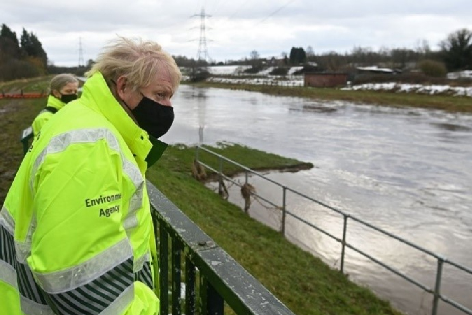
Prime Minister Boris Johnson and Environment Agency Chair, Emma Howard Boyd
Table 1: properties flooded by Environment Agency area 19 to 28 January 2021
| Environment Agency area | Approximate number of properties flooded |
|---|---|
| Cumbria and Lancashire | 10 |
| Essex, Norfolk and Suffolk | 10 |
| East Midlands | 30 |
| Greater Manchester, Merseyside and Cheshire | 650 |
| North East | 10 |
| Shropshire, Herefordshire Worcestershire and Gloucestershire | 110 |
| Staffordshire, Warwickshire and West Midlands | 20 |
| Thames | 30 |
| Yorkshire | 30 |
Isolated properties in other parts of England were also flooded.
View a map of Environment Agency areas.
2.2 National flood and coast erosion risk management strategy and action plan
The Flood and Water Management Act 2010 states that the Environment Agency must develop, apply, maintain, and monitor a strategy for FCERM in England.
On 14 July 2020, the National Flood and Coastal Erosion Risk Management Strategy for England (the FCERM Strategy) was laid in Parliament. Following Parliamentary scrutiny, the FCERM Strategy was adopted by Parliament. The Environment Agency published it on 25 September 2020.
The FCERM Strategy contributes to our strategic role for all flood and coastal erosion risk management activities. The FCERM Strategy is a statutory framework to guide those involved in FCERM to achieve its ambitions on the ground. The FCERM Strategy compliments and will help achieve the aims of the government’s FCERM policy statement released on 14 July 2020.All RMAs have a duty to act consistently with the FCERM Strategy when carrying out their FCERM roles.
Alongside the FCERM Strategy, the Environment Agency published the following supporting information:
- statement of environmental particulars
- final habitats regulations assessment
- consultation responses document
The FCERM Strategy’s long-term vision is for a nation ready for, and resilient to, flooding and coastal change – today, tomorrow and to the year 2100. It has 3 ambitions:
- climate resilient places
- today’s growth and infrastructure resilient in tomorrow’s climate
- a nation ready to respond and adapt to flooding and coastal change
RMAs will achieve the ambitions through 21 strategic objectives over the next 10 to 30 years. There are also 56 shorter term measures that set out the immediate steps they are taking for each objective.
On 12 May 2021, the Environment Agency published its Flood and Coastal Erosion Risk Management Strategy Action Plan 2021. It identifies and tracks the practical actions needed for the year ahead. We will publish a progress update in spring 2022.
2.3 Changes to government policy and highlighted announcements
The government’s FCERM policy statement sets the long-term ambition to create a nation more resilient to future flood and coastal erosion risk. The policy statement outlines 5 ambitious policies and over 40 supporting actions. These will better protect and prepare the country against flooding and coastal change.
The policy statement will encourage wider and more comprehensive action through:
- upgrading and expanding our national flood defences and infrastructure
- managing the flow of water more effectively
- harnessing the power of nature to reduce flood and coastal erosion risk
- better preparing our communities
- enabling more resilient places through a catchment-based approach
Between 1 April 2020 and 31 March 2021, the government made several funding announcements, including the following in July 2020:
- a record £5.2 billion to build around 2,000 new FCERM schemes
- an extra £170 million to speed up work on 22 flood and coastal risk management schemes
- £200 million to part fund FCERM innovative resilience actions in 25 areas in England
On 26 August 2020, the government published an independent review of the arrangements for determining responsibility for surface water and drainage assets. The report’s recommendations will make these arrangements more efficient, straightforward, and effective. The government immediately accepted 12 of the recommendations. The government has since considered the full review. In response, the surface water management: a government update was published on 29 July 2021.
In January 2021, the government published a consultation on changes to the National Planning Policy Framework (NPPF). It included some aspects of planning policy related to flood risk. The NPPF text was revised to implement policy changes in response to the Building Better, Building Beautiful Commission ‘Living with Beauty’ report.
In February 2021, the government published a Call for Evidence. It sought views on how to take local factors into account in the FCERM investment programme. Those local factors included communities that:
- have been frequently flooded
- are more economically vulnerable
- need greater property flood resilience measures
In the same month the government also launched a consultation on proposed changes to the Flood Re scheme.
2.4 Inquiries and reviews
The National Audit Office (NAO) published its managing flood risk report in November 2020. The report evaluates whether the government’s approach to managing the risks of flooding and coastal erosion is achieving value for money. The report contains 3 recommendations for the Environment Agency to:
- update and improve the methodology for calculating the risk reduction achieved from its investment programme
- report on the geographical distribution of investment
- review and update the current approach to communicating with third-party asset owners
The Environment Agency has begun to put these recommendations in place. Work is underway to update the methodologies for collecting information and reporting on changes in flood risk over time. We will have an interim updated method in place by spring 2022. We will publish more information about this interim approach in the 2021 to 2022 FCERM annual report.
The new National Flood Risk Assessment (NaFRA) will be available in 2024. This will provide a comprehensive means of assessing and measuring changes in risk from all sources of flooding.
We have agreed with government on how we will report on properties better protected from flooding and coastal change through our investment. This includes measures to look at funding for deprived areas and where funding is distributed across England.
We have reviewed and made clearer the actions required when a third party asset is identified as below the required condition by our asset performance teams. Third party assets are owned and maintained by individuals or organisations such as local authorities, iDBs, and landowners. The Environment Agency’s asset performance teams inspect these third party assets.
A Public Accounts Committee (PAC) hearing followed the NAO report in January 2021. On 26 February 2021, the PAC published the managing flood risk report. The Environment Agency’s response to the PAC was captured in the Treasury Minutes published on 17 May 2021.
The government is leading on 15 actions and the Environment Agency on 4 actions. We are engaging with and supporting the government to complete their actions. In addition to the NAO recommendations the Environment Agency must:
- review maintenance investment
- set out further detail on moving to digital for planning notices
We have carried out an initial review of maintenance investment over the next 5 years. In 2023, we will do a more comprehensive review to inform our longer-term maintenance needs.
In September 2021, we published more detailed information on when planning permission is granted against Environment Agency advice.
3. Current risk and investment
This section provides information on flood risk, FCERM investment and partnership working.
3.1 Properties at risk of flooding
Sources of flooding include:
- rivers
- the sea
- surface water
- groundwater
Some properties are at risk from more than one source of flooding.
Table 2: properties in areas at risk of flooding from rivers and the sea, and from surface water as of 31 March 2021
| Level of risk | Annual likelihood of flooding (percentage) | Total number of properties in areas at risk of flooding from rivers and the sea | Number of residential properties in areas at risk of flooding from rivers and the sea | Total number of properties in areas at risk of flooding from surface water | Number of residential properties in areas at risk of flooding from surface water |
|---|---|---|---|---|---|
| High | Greater than 3.3 | 198,000 | 120,000 | 326,000 | 241,000 |
| Medium | 1 to 3.3 | 648,000 | 444,000 | 499,000 | 391,000 |
| Low | 0.1 to 0.99 | 1,024,000 | 773,000 | 2,348,000 | 1,874,000 |
| Very low | Less than 0.1 | 629,000 | 522,000 | not assessed | not assessed |
| Total | not applicable | 2,498,000 | 1,859,000 | 3,173,000 | 2,506,000 |
Due to the complexity and nature of groundwater flooding, we are not able to assign a likelihood to it.
3.1.1 Changes in properties at risk from flooding and coastal change
The numbers of properties at risk from flooding and coastal change will change over time. This is due to a range of factors including:
- new development pressures
- changes to the natural environment
- the increasing impacts of climate change
- investment in building and maintaining flood and sea defences
- ageing defences that require maintenance or replacement
All these factors will influence the total number of properties at risk of flooding in any given year and in any given location.
The Environment Agency uses flood mapping and modelling to understand the risk of flooding at national and local levels. We developed our current NaFRA in the early 2000s. It provides risk information on flooding from rivers and the sea. Since then, we have significantly improved our:
- mapping and modelling
- understanding of flood risk from other sources such as surface water
In 2018 this led to a significant national scale update to our measurement of flood risk.
Our NaFRA indicates there are 53,000 fewer properties with a medium to high risk of flooding from rivers and the sea in 2020 to 2021 compared with 2015 to 2016. This is about a 5 to 6% reduction in risk across the nation. A medium or high risk is equal to or greater than 1% annual likelihood of flooding.
Table 3: properties at risk of flooding by source each year from 1 April to 31 March from 2015 to 2021
| Source of flooding | Number of properties at risk 2015 to 2016 | Number of properties at risk 2016 to 2017 | Number of properties at risk 2017 to 2018 | Number of properties at risk 2018 to 2019 | Number of properties at risk 2019 to 2020 | Number of properties at risk 2020 to 2021 |
|---|---|---|---|---|---|---|
| Rivers and the sea | 2.7 million | 2.7 million | 2.6 million | 2.5 million | 2.5 million | 2.5 million |
| Rivers and the sea at high or medium risk | 899,000 | 897,000 | 897,000 | 872,000 | 852,000 | 846,000 |
| Surface water | 3 million | 3.2 million | 3.2 million | 3.2 million | 3.2 million | 3.2 million |
| Groundwater | 122,000 – 290,000 | 122,000 – 290,000 | 122,000 – 290,000 | 122,000 – 290,000 | 122,000 – 290,000 | 122,000 – 290,000 |
Some properties are at risk from flooding from multiple sources. For example, we estimate that 660,000 properties are at risk from flooding both from rivers, the sea, and surface water. The figures for groundwater in table 3 may also include properties at risk of flooding from other sources.
3.2 Investment in FCERM
Between 1 April 2015 and 31 March 2021, the government provided £2.6 billion of investment to the Environment Agency. This 6 year investment programme aimed to better protect 300,000 homes from flooding and coastal change. By March 2021, we had exceeded this target, with 314,000 homes better protected. We achieved this by working with partners to complete more than 850 FCERM schemes.
The Environment Agency distributed £580 million to other RMAs to work on 543 FCERM schemes that better protectd 105,000 homes. This includes LLFAs and IDBs who use the funding for FCERM schemes.
LLFAs invested £160 million of capital local levy. This investment contributed to schemes that better protect 40,000 homes. The local levy is a fund raised from LLFAs by the Environment Agency for RFCCs local priority FCERM schemes.
The Environment Agency reviews the FCERM investment programme each year to make sure that we:
- get the best value for money
- reach any set targets for better protecting homes
This means the amount of funding invested each year can vary.
Table 4: FCERM funding type in £ millions from 1 April to 31 March for each year from 2015 to 2021
| Type of funding | 2015 to 2016 | 2016 to 2017 | 2017 to 2018 | 2018 to 2019 | 2019 to 2020 | 2020 to 2021 |
|---|---|---|---|---|---|---|
| Central government (£millions) | £391 | £447 | £403 | £453 | £501 | £495 |
| Local levy (£millions) | £16 | £23 | £28 | £33 | £36 | £24 |
| Funding from other sources (£millions) | £31 | £32 | £31 | £24 | £33 | £51 |
The funding from other sources of £51 million for 1 April 2020 to 31 March 2021 is an indicative amount. The government will publish the final agreed amount in the Central Funding for FCERM report in spring 2022.
Investment is prioritised where the risk is highest. This is regardless of where it is in the country. This provides a fair and consistent basis for allocating central government funding.
Table 5: government investment in FCERM per Office for National Statistics (ONS) region from 1 April to 31 March each year from 2015 to 2021 in £ millions
| ONS region | 2015 to 2016 £ millions | 2016 to 2017 £ millions | 2017 to 2018 £ millions | 2018 to 2019 £ millions | 2019 to 2020 £ millions | 2020 to 2021 £ millions |
|---|---|---|---|---|---|---|
| East Midlands | £29 | £37 | £39 | £57 | £65 | £54 |
| East of England | £68 | £35 | £31 | £42 | £53 | £53 |
| London | £16 | £25 | £29 | £27 | £31 | £36 |
| North East | £16 | £14 | £12 | £12 | £10 | £8 |
| North West | £51 | £72 | £39 | £47 | £52 | £70 |
| South East | £67 | £62 | £84 | £76 | £71 | £66 |
| South West | £41 | £50 | £45 | £47 | £44 | £43 |
| West Midlands | £13 | £14 | £15 | £24 | £31 | £35 |
| Yorkshire and the Humber | £55 | £87 | £64 | £84 | £119 | £102 |
| Other | £33 | £52 | £44 | £35 | £26 | £24 |
| Total | £391 | £447 | £403 | £453 | £501 | £495 |
3.2.1 Other benefits of FCERM investment
The priority of the 2015 to 2021 investment programme was to better protect homes from flooding and coastal change. This investment programme also realised other benefits to support businesses and economic growth. Other benefits included:
- better protecting 229,000 hectares (ha) of agricultural land
- better protecting 8,600km of roads
- better protecting 570km of railways
- creating 4,500ha of natural habitat
- enhancing 600km of river
Table 6: other benefits of FCERM investment from 1 April to 31 March each year from 2015 to 2021
| Type of benefit | 2015 to 2016 | 2016 to 2017 | 2017 to 2018 | 2018 to 2019 | 2019 to 2020 | 2020 to 2021 |
|---|---|---|---|---|---|---|
| Agricultural land (ha) | 74,644 | 30,442 | 32,838 | 36,307 | 28,382 | 26,136 |
| Commercial properties | 11,500 | 7,041 | 7,595 | 8,677 | 8,333 | 7,471 |
| Roads (km) | 1,854 | 1,090 | 1,176 | 1,343 | 1,591 | 1,537 |
| Rail (km) | 150 | 51 | 55 | 63 | 117 | 134 |
3.2.2 Significant schemes completed
Government set a target to better protect 300,000 homes from flood and coastal erosion between 1 April 2015 and 31 March 2021.
Between 1 April 2020 and 31 March 2021, the Environment Agency worked with other RMAs to complete 176 FCERM schemes. These schemes better protected people and homes from:
- sea flooding (32 schemes)
- river flooding (85 schemes)
- surface water flooding (50 schemes)
- coastal erosion (9 schemes)
In total, between 1 April 2015 and 31 March 2021, the Environment Agency worked with other RMAs to complete more than 850 FCERM schemes. These schemes provided better protection from:
- sea flooding (180,000 homes and 117 schemes)
- river flooding (85,000 homes and 418 schemes)
- surface water (22,000 homes and 246 schemes)
- coastal erosion (27,000 homes and 63 schemes)
- reservoirs (120 homes and 2 schemes)
- groundwater (180 homes and 4 schemes)
These schemes helped better protect:
- 287,360 homes from flooding – 45,800 of these are in areas of significant flood risk and socio-economic multiple deprivation
- 27,000 homes from coastal erosion - 700 of these are in areas of significant flood risk and socio-economic multiple deprivation
Case study 1: Boston Barrier
The Environment Agency worked on the Boston Barrier Scheme in partnership with:
- Lincolnshire County Council
- Boston Borough Council
- Black Sluice Internal Drainage Board
The £100 million scheme was fully funded by FCERM government investment. It is part of the Boston Combined Strategy that was approved in 2008. The Boston strategy identified 5 separate phases of work to reduce the risk of tidal flooding and regenerate the town’s waterways. The project is part of phase 3 of the Boston strategy and consists of a tidal barrier across the Haven, downstream of the town, with associated defence works.
The Boston Barrier gate became fully operational in December 2020. It provides an enhanced level of flood protection to over 13,000 properties and businesses in the town. The Barrier is a steel sector gate, rising from the riverbed, to allow vessels to pass through on the busy working river. The Barrier gate can be raised in 20 minutes in response to North Sea tidal surges. The Barrier weighs over 700 tonnes, and measures 28 metres wide and 11.5 metres high.
The Boston Barrier was designed and constructed following the UN Sustainable Development Goals to minimise its carbon and environmental footprint.
3.2.3 Partnership funding
Funding for FCERM schemes is allocated in line with the government’s partnership funding policy. The amount of funding a scheme is allocated depends on the damages it will avoid and the benefits it will provide. The schemes that are allocated government funding are those that:
- better protect a greater number of homes
- better protect a greater number of homes in deprived areas
- provide wider economic benefits
- create or enhance habitats
Government funding does not always cover the full cost of a scheme. Partnership funding contributions are then required from those that will benefit from the scheme. Contributions may come from:
- local partners
- the local community
- other organisations or businesses
Securing partnership funding is often central to the completion of many schemes. Partnership funding contributions enables more communities to benefit from local FCERM measures that could not be funded by central government alone.
Thanks to our impressive partnerships, since 2015 the Environment Agency has secured around £600 million in partnership funding. This funding has come from various private and other non-central government sources. Around 60% of FCERM schemes completed between 2015 and 2021 required partnership funding. This extra funding enabled us to exceed our target and better protect 314,000 homes by March 2021.
In April 2020, the government announced several amendments to the partnership funding policy. These changes applied from April 2021 and included:
- updated payment rates to account for the mental health impacts of flooding
- increased payments for environmental benefits such as nature-based solutions
- more funding for schemes that better protect properties that will later become at risk of flooding due to climate change
- amended flood risk bands to enable more surface water schemes to qualify for funding
Case study 2: Preston and South Ribble Flood Risk Management scheme
The Preston and South Ribble Flood Risk Management scheme will better protect approximately 4,700 homes and businesses from flooding.
The Environment Agency is developing the scheme with:
- Lancashire County Council
- Preston City Council
- South Ribble Borough Council
The scheme will cost £54.7 million, with partnership funding contributing around half of the scheme cost. The European Regional Development Fund is contributing £6.5 million to the scheme. The Department for Education are also contributing to the cost of the scheme. The scheme includes improving the existing defences by installing glass panels. This will help better protect the local community from flooding and maintain the river views.
The Environment Agency is also working with local schools that will benefit from the scheme. We have already started building 3 new football pitches which will also store flood water. The project team are working with the local cycling group. We want to ensure that the group can continue to use a 26 mile cycleway when construction starts. The cycleway runs the length of the scheme.
We will also create a new wetland habitat and 4 accessible community allotment plots as part of the scheme. The scheme will be completed in 2024.
3.2.4 Asset management
The Environment Agency maintains around 74,000 assets that have a flood or coastal risk management purpose in England. These include:
- 5,000km of defences on main rivers
- 1,200km of tidal defences
- 600km of coastal defences
- 200km of culverts
- 20,000 structures, such as groynes, sluices, outfalls and screens
Between 1 April 2020 and 31 March 2021, the Environment Agency invested over £200 million on maintaining FCERM assets. The investment includes developing technology and maintenance activities, such as:
- inspecting, maintaining and operating assets
- channel maintenance
On average, each year we inspect over 175,000 flood risk management assets. These are maintained by:
- the Environment Agency
- other RMAs
- third parties
On 31 March 2021, 94.5% of Environment Agency maintained flood risk assets in high consequence flood risk management systems were in the required condition. A high consequence system is a location where there is a high concentration of properties. Several flood defences work together to reduce flood risk and better protect that area.
Assets that are below the required condition need extra maintenance work. It does not mean they have structurally failed or will not perform as required in a flood. If an asset’s performance is reduced, we will take action to manage flood risk until we repair or replace it.
The government provided the Environment Agency an additional £120 million between 1 April 2020 and 31 March 2021. This was to repair and enhance defences that were damaged in the winter 2019 to 2020 flooding.
We publish details of planned maintenance activities in the river and coastal maintenance programme.
3.3 Public sector cooperation agreements
The FWMA 2010 says RMAs must cooperate with each other when carrying out FCERM activities. RMAs can work together to provide flood risk maintenance and other activities. One example of partnership working is public sector cooperation agreements (PSCAs). The benefits of partnership working are now well established.
The Environment Agency uses PSCAs for a wide variety of work including:
- routine maintenance
- small improvement works
- incident response
We will continue to increase the number of PSCAs and their use where appropriate.
Table 7: summary of national PSCAs on 31 March 2021
| PSCAs status | Internal drainage board | Lead local flood authority | Navigation authority | Total |
|---|---|---|---|---|
| PSCAs in place | 39 | 12 | 3 | 54 |
| PSCAs in principle | 9 | 8 | 0 | 17 |
| Renewals in progress | 17 | 0 | 0 | 17 |
3.4 Efficiency savings
The Environment Agency is required to report to government about FCERM efficiency. This is to achieve the best possible value for the investment of government funds. This is a rule of Her Majesty’s Treasury. Opportunities to improve efficiencies come from:
- national initiatives that allow operational improvements
- local project specific activities
Savings are achieved through:
- innovation
- value engineering
- longer-term planning and packaging of work
Since April 2015, we have achieved £297 million in efficiency savings. Efficiencies vary from year to year. They depend on:
- the FCERM funding allocation for that year
- individual project completion dates
Table 8: FCERM efficiencies achieved each financial year (1 April to 31 March) between 2015 and 2021
| Period | 2015 to 2016 | 2016 to 2017 | 2017 to 2018 | 2018 to 2019 | 2019 to 2020 | 2020 to 2021 |
|---|---|---|---|---|---|---|
| Efficiency saving in £ millions | £50 | £40 | £45 | £43 | £50 | £69 |
4. Ambition 1 - climate resilient places
This section provides information on how RMAs are working together to increase resilience to flooding and coastal change, both now and in the future.
4.1 Climate change
Our climate is changing, sea levels are rising, and we are experiencing more extreme weather. The year 2020 was warmer than average for the UK and ranks as the third warmest year on record. It was also the sixth wettest year in a series from 1862, and the eighth sunniest since 1919. It is remarkable for being ranked in the top 10 for all 3 variables.
After a notably wet winter, there were drier and more settled weather patterns from mid-March 2020. The UK had a record-breaking sunny spring. A temperature of 37.8°C was recorded at Heathrow Airport on 31 July 2020. This made it the third hottest day ever recorded in the UK.
Unseasonable weather brought summer 2020 to a close with 2 named storms. Storm Ellen occurred on 19 August and Storm Francis on 24 August. While having named storms in a summer month is not unprecedented, it is unusual to have 2 so close in succession.
The rainfall in December 2020 was well above average in most areas, and above double the average in some places. The UK had 135% of the average rainfall. January’s rainfall was also above average in most places.
The scale of potential future flooding and coastal change is significant. As climate change leads to sea level rise and more extreme rainfall, the number of people at risk from flooding and coastal erosion will grow. The Climate Change Committee’s 2021 Progress Report recognises these risks. There are 2 main ways we can tackle climate change:
- mitigation - reducing or limiting the effects of greenhouse gases to reduce the impacts of a changing climate
- adaptation - changing our lifestyles, economy, infrastructure to adapt to the unavoidable impacts of climate change
We need to both mitigate and adapt to minimise risks from climate change.
4.1.1 Mitigation
In July 2020, the Environment Agency launched its 5-year action plan, EA2025: creating a better place. The plan sets out our long-term goals and puts the climate crisis at the centre of everything we do. It aligns with our eMission 2030 strategy which commits us to become net zero carbon (NZC) by 2030.
By becoming NZC, we aim to balance the emissions we produce with those we remove from the atmosphere. To get to NZC, we need to reduce our emissions by at least 45% by 2030.
New tools and processes to reduce carbon emissions at a catchment level and for each step of the asset life cycle are now in place. We have completed a series of initiatives, from research and development studies to pilots, to help us reach our NZC target.
In 2020, construction contributed to 54% of the Environment Agency’s carbon emissions. This includes emissions from our supply chain. We need to avoid producing carbon emissions whenever possible in our projects. When a project cannot avoid carbon emissions, we ask our supply chain to maximise the reduction of the carbon dioxide produced. We capture these carbon reduction opportunities in our roadmap to NZC.
Pumping water generates almost one-third of our carbon emissions. We are working on a decarbonisation programme for our Mechanical, Electrical, Instrumentation, Control and Automation work. This will investigate if pumping is essential or if we can avoid it by using NFM. When pumping is needed, we plan to optimise our pumping stations’ performance. We are exploring how to use the latest technologies to take our assets off the electricity grid by using renewable energy. We are piloting a Micro Hydroelectric scheme to generate and store energy from renewable sources.
Case study 3: Upgrading Bentley Ings Pumping Station
Bentley Ings Pumping Station was built in 1942. The purpose of the station was to better protect over 1600 properties from the risk of flooding from the River Don.
In 2007, 400 properties flooded in Doncaster. This triggered the need to replace or redesign the pumping station. The preferred option was to re-use rather than replace the asset. The aim of this was to help minimise cost and save carbon. Innovative methods were used to survey the existing assets. This confirmed that the structure could be re-used.
The Environment Agency increased the pumping volume by 20% to offset for future climate change. The pumping station was also made more resilient through extra power and pump capacity. The project achieved £8 million capital savings, 60% carbon savings, and 12% cost efficiencies. By re-using the existing structures, it reduced both construction and demolition waste.
The pumping station now better protects 3000 properties from flooding.
4.1.2 Adaptation
The FCERM Strategy plans for a 2˚C global temperature increase by 2100. It also prepares for more extreme scenarios of climate change. It calls for an assessment of a range of climate impacts. This will ensure our approach to FCERM can adapt to a range of climate futures. We’re doing this in both our planning advice for new developments and for the design of new FCERM schemes and strategies. We have ensured this guidance reflects the latest climate science.
In July 2020, we updated our guidance for RMAs on how to account for climate change in projects, schemes and strategies when applying for FCERM funding.
We updated our sea level rise allowances to reflect the UK Climate Projections 2018. The updated guidance is in line with our partnership funding and appraisal guidance. This supports the FCERM Strategy’s ambition to plan for a range of climate futures.
4.1.3 Resilience
In the March 2020 budget, the government announced a £200 million fund to improve the resilience of places to flooding and coastal change. The government allocated £150 million to develop the Flood and Coastal Resilience Innovation Programme. The Environment Agency manages the programme. The 25 projects in the programme aim to share their evidence and learning to inform future approaches to, and investments in FCERM.
In March 2021, the Secretary of State announced the 25 projects selected to receive funding. Each project will develop innovative flood and coastal resilience actions between 2021 and 2027.
The 25 projects include:
- piloting property flood resilience to reduce the impacts of groundwater flooding
- developing nature-based solutions with rural land managers to improve resilience to floods and drought
- developing surface water flood warnings for remote communities
- creating new habitat to increase shoreline resilience and better protect local coastal economies
- trailing new and innovative financing to improve flood and coastal resilience
4.2 Coastal change
The National Coastal Erosion Risk Map (NCERM) currently indicates that by 2060 about 2,000 properties are at risk of being lost to coastal erosion. This assumes all current shoreline management plan (SMP) policies are implemented.
During 2020 to 2021, we asked users about how they prefer to view erosion projections online. By 2023, the Environment Agency will update the NCERM to ensure it reflects the latest evidence on coastal erosion and sea level rise. The Environment Agency will work with coastal monitoring partners to account for the latest evidence on coastal processes.
Coast protection authorities (CPAs) have permissive powers. These powers allow them to carry out flood and coastal erosion risk management works. Some CPAs in England have also helped manage adaptation by introducing local planning mechanisms. These can include helping people move further inland (rollback) from areas of risk along the coast. Local authorities in East Anglia are working to better understand finance requirements for adaptation to coastal change.
4.2.1 Shoreline management plans (SMPs)
SMPs set out the local approach to coastal adaptation, investment and spatial planning into the next century. They identify the most sustainable management approach for each stretch of coastline in England. The management approaches cover the:
- short-term (0 to 20 years)
- medium term (20 to 50 years)
- long term (50 to 100 years)
SMPs were developed by CPAs, the Environment Agency and other important stakeholders working together in 7 regional Coastal Groups across England.
The government is working with coastal authorities to review the SMPs developed between 2006 and 2012. The Environment Agency is coordinating the work with support from the Coastal Groups.
The review will ensure that SMPs are up to date and use the best available evidence for their recommendations. This will support planning and investment at the coast into the next century. It is also an opportunity to ensure that:
- we are doing all we can to steer coastal management on a sustainable course
- coastal authorities have a properly resourced plan to achieve this
In October 2020, the Environment Agency provided a ‘health check’ (progress) report for each SMP to the Coastal Groups. The report highlighted any areas of concern in realising the management objectives in the SMPs. We also shared guidance to highlight developments in government policy that might influence the plans. The new guidance also sets out how to make SMPs clearer for those using them to make decisions. Since January 2021, Coastal Groups have used the guidance to clarify the management approaches in each SMP.
Between January and March 2021, we consulted with users of coastal information on how to make SMPs easier to read and maintain. This will help us build a new online platform for SMPs so they are easier to access and understand. By spring 2024, the Environment Agency will publish a new SMP Explorer. The SMP Explorer will provide regularly updated SMP information in digital map format. This will enable users to interrogate the maps.
4.2.2 Coastal habitats
FCERM schemes can sometimes cause loss of valuable coastal habitat. When building and maintaining FCERM assets the Environment Agency must compensate for:
- any lost habitats
- a loss in the quality of habitats
Most losses will arise from coastal squeeze. This is where flood risk management assets prevent the natural landward migration of habitats. Compensation in these cases normally involves creating new habitat. The Environment Agency produces long-term forecasts for how much habitat we expect to lose from coastal squeeze.
Since the early 2000s, the Environment Agency has had a national Habitat Compensation Programme. This programme plays an important role in monitoring habitat gains and losses. It also supports the development of replacement habitat to overcome the losses and increase carbon storage.
In January 2021, the FCERM Research and Development Programme published new research on what causes coastal squeeze and how it can be measured and predicted. As part of the SMP review, we are also updating our understanding of coastal saltmarsh loss over the last 10 years. These projects will improve the consistency and reliability of our Habitat Compensation Programme.
4.2.3 Inter-tidal saltmarsh and mudflats
Our knowledge and engineering of saltmarsh restoration has improved significantly over time. Saltmarshes can store carbon, filter out excess nutrients and provide other environmental benefits. Since the early 2000s, the Environment Agency has created over 900 hectares of inter-tidal habitat (saltmarsh and mud flats). Despite this progress, we expect to continue to lose coastal habitat as a result of sea level rise over time.
We are also leading on the Restoring Meadows, Marsh and Reef initiative. This project is looking at ways to restore saltmarsh and other estuarine and coastal habitats beyond what is needed to compensate for habitat losses. It shares experience among various coastal and marine agencies on:
- facilitating funding
- guidance
- regulatory issues when undertaking estuarine and coastal restoration projects
In the future it aims to engage in more direct restoration work.
4.2.4 Other coastal habitats
Other protected habitats around the coast also experience pressure from FCERM activity. These include:
- saline lagoons and vegetated shingle
- freshwater habitats such as reed bed and coastal grazing marsh
The Environment Agency has created 600 hectares of these habitats since the early 2000s. These have compensated for losses associated with coastal erosion and coastal change. These are mainly reed bed and grazing marsh situated on the east and south-east coast. We need to continue to create these habitats as there are likely to be losses as a result of future schemes.
4.3 Natural flood management (NFM)
NFM protects, restores or copies the natural function of:
- rivers and their floodplains
- estuaries
- the coast
NFM can reduce flood and coastal erosion risk, and offer other benefits such as:
- creating or restoring important wildlife habitat
- improving the local environment and landscape
- creating recreation opportunities
- capturing and storing carbon
- improving water quality
There were 74 NFM related projects in the 1 April 2015 to 31 March 2021 FCERM capital investment programme. Examples include:
- tree planting, building leaky barriers in rivers and peatbog restoration in the upper catchment
- floodplain restoration, land and soil management in mid-catchment
- the management and creation of coastal marsh and sand dune systems in coastal areas
The FCERM Strategy will help achieve the aims and ambitions of the 25 Year Environment Plan by embracing nature-based solutions. Nature-based solutions will enhance and protect the environment as well as reducing flood risk. NFM and the provision of green-infrastructure are examples of nature-based solutions.
In the FCERM policy statement, the government committed to double the number of FCERM schemes which include nature-based solutions in the new investment programme.
4.3.1 NFM programme
Following the Autumn Statement 2016, the government announced £15 million of funding for NFM. The Environment Agency allocated this funding to 58 projects in the NFM programme.
The NFM programme ran from 2017 to March 2021. Some projects will be completed in 2022 because of delays as a result of COVID-19. Some projects will continue with the support of other organisations and their local community. Most projects will continue to collect data for many years to come. The projects will:
- reduce flood and coastal erosion risk
- improve habitats and increase biodiversity
- contribute to research and development to reduce the evidence gap for NFM
- encourage and support partnership working
As of 31 March 2021, there were 2 catchment and 4 community led projects that remained in progress. The Environment Agency tracks the NFM programme. This helps us understand the flood risk and environmental benefits that it offers. We published the programme’s initial findings report Using the power of nature to increase flood resilience on 1 November 2021. We aim to update the working with natural processes evidence directory in 2023.
Case study 4: Dartmoor Headwaters Natural Flood Management Pilot
Dartmoor is an upland landscape located in South West England. It is the source of many of Devon’s rivers. The area receives high levels of rainfall, which at times causes flooding in the surrounding communities.
The Dartmoor Headwaters NFM project aims to reduce flood risk to communities on and around Dartmoor using natural solutions.
The pilot phase of the project ran from 2018 to 2021. The Environment Agency’s NFM Programme funded the project. The project received £834,000. This was used to put in place nature-based solutions and research their effectiveness to managing flood risk.
The project:
- worked with hill farmers in 5 river catchments to restore the condition of soils
- funded 75 ha of peatland restoration through the South West Peat Partnership
- created new and expanded existing woodlands with thousands more trees
- restored rivers and their floodplains to hold more water for longer
- installed over 350 ‘leaky dams’ to hold back the flood peak using a variety of materials from stone and timber to sheep’s fleece
- reduced soil compaction caused by overgrazing from increased animal populations
- influenced plans for burning of the moor away from flood prone areas
- collaborated on a woodland hydrology PhD with Plymouth University
These solutions, and the many others used, work together in the landscape to ‘slow the flow’ of a flood. They also provide many other benefits including:
- storing carbon dioxide
- improving water quality
- increasing biodiversity
Records from the project show that the features installed have successfully ‘slowed the flow’ at a local scale. The project will monitor the solutions for a longer period to determine the full impact.
To date this project has contributed to many of the 25 Year Environment Plan’s goals including:
- reducing the risks of harm and environmental hazards
- mitigating and adapting to climate change
- clean and plentiful water
- thriving plants and wildlife
- using resources from nature more sustainably and efficiently
The project has secured a second phase of funding to continue the pilot from 2021 to 2027. This will allow the project to continue installing more features and expand to other areas of Dartmoor.
4.4 Improving the environment
RMAs look for opportunities to create and improve habitat as part of their FCERM work. They often form partnerships with groups such as wildlife and rivers trusts. The environmental improvements completed by RMAs from 1 April 2020 to 31 March 2021 include:
- enhancing 157km of waterbodies
- enhancing 1222ha of habitat
- creating 507ha of habitat
Examples of these improvements include:
- removing or modifying weirs to make it easier for fish to migrate upstream
- creating and restoring peatland habitat to help manage water runoff and reduce flood risk downstream
Changes to the partnership funding policy were announced in April 2020. These included updates to the way environmental benefits are funded as part of FCERM schemes. They will help to capture the wider environmental benefits achieved and encourage environmentally beneficial designs. We will continue to report on the environmental benefits provided through FCERM investment.
4.5 Strategic planning: flood risk management plans
The flood risk management plans (FRMPs) published in March 2016 cover the 6-year period 2015 to 2021. They set out how RMAs will work together with communities to manage and reduce the risk of flooding. FRMPs contain measures to manage flood risk in flood risk areas and across river basin districts. This follows the statutory process set out in the Flood Risk Regulations 2009.
Table 9: progress made towards implementing flood risk management plan measures for the period 2015 to 2021 as of 31 March 2021
| Progress | Number of measures |
|---|---|
| Ongoing | 3330 |
| Complete | 1271 |
| Superseded | 836 |
| Not started | 484 |
Some of these measures will go on beyond 2021 and will continue in the second cycle FRMPs. The Environment Agency, LLFAs and other RMAs are working together to review the first cycle FRMPs.
We are producing draft second cycle FRMPs for the period 2021 to 2027. These went through a public consultation in autumn 2021. The draft second cycle FRMPs are strategic, place-based plans. Their objectives and measures will contribute to the ambitions in the FCERM Strategy. The draft second cycle FRMPs will also:
- aim to support achieving wider environmental ambitions
- be co-ordinated with draft river basin management plans
5. Ambition 2 - today’s growth and infrastructure resilient in tomorrow’s climate
Making the right investment and planning decisions to secure sustainable growth and environmental improvements, as well as infrastructure resilient to flooding and coastal change.
5.1 Promoting safe development resilient to flooding and coastal change
We predict that the number of homes in the floodplain will almost double over the next 50 years. Climate change will also increase the:
- size of flood risk areas
- frequency and severity of flooding
- complexity of the flood risk issues needing to be tackled
Spatial planning has an important role in minimising the flood damages that these trends could cause. The NPPF makes it clear that we should avoid inappropriate development in areas at risk of flooding. Where development has to take place in flood risk areas, it should:
- be designed to be safe throughout its lifetime
- not increase flood risk elsewhere
Development design should be flood resistant and resilient. This will minimise flood damage and speed up recovery in the event of flooding.
The Environment Agency has an important role as a statutory planning advisor to local planning authorities (LPAs). We support sustainable development by engaging with, and advising, developers and planners. By doing this, we help to support sustainable growth in the right places.
Investing in flood risk planning advice makes good economic sense. For every £1 we spend providing advice, around £12 of future flood damages are avoided.
We comment on development proposals:
- in areas that are currently at medium or high risk of flooding from rivers and the sea
- in areas with critical drainage problems
- within 20 metres of a main river
We are not a statutory consultee:
- on development in flood zone 1 which we expect to be at risk of flooding from rivers or the sea in the future
- when proposed development could be at risk from other sources of flooding such as ground or surface water
LLFAs are a statutory consultee on major development with surface water drainage.
The Environment Agency responds to approximately 11,000 planning applications each year. We provide detailed flood risk advice for around 7,000. Our flood risk planning advice helps to avoid around 40,000 homes from being built each year in an unsafe way or location.
Between 1 April 2020 and 31 March 2021:
- 97.1% of all planning decisions were in line with Environment Agency advice on flood risk
- 97.7% of new homes proposed in planning applications complied with Environment Agency advice on flood risk
- planning permissions for 637 homes were granted against Environment Agency advice on flood risk
The Environment Agency records a sample of planning application outcomes. This gives us an understanding of how effective our advice is. It enables us to focus our efforts on positively influencing development proposals. We recorded fewer decision notices this year due to the impacts of COVID-19 and the need to reprioritise staff and work.
We recorded the final decisions LPAs made for 1,137 planning applications where we lodged flood risk objections. These cases totalled 27,522 homes overall. This is a sample of the decision notices published on various LPAs websites. It provides an overview of the outcome of decision notices across England. Between 1 April 2016 and 31 March 2021, we recorded the LPA’s final decision for around 63% of the applications we objected to on flood risk grounds.
We publish a list of all applications where we’ve lodged initial objections on flood risk grounds. Often, the issues are resolved before a final decision is made. In the FCERM Strategy action plan (2021) we committed to reporting where planning permission is granted against our advice. We published this new information in September 2021.
Table 10: planning applications reviewed by the Environment Agency between 1 April 2020 to 31 March 2021
| Type of action | Total |
|---|---|
| Planning applications responded to | 10,486 |
| Planning applications which required detailed flood risk advice | 6,725 |
| Number of planning decisions recorded that related to flood risk objections | 1,137 |
| Number of homes granted planning permission contrary to Environment Agency flood risk advice | 637 |
| Number of planning decisions recorded in line with our advice | 1,104 |
| Number of planning decisions made contrary to our flood risk advice | 33 |
| % of planning applications determined in line with the Environment Agency’s advice | 97.1% |
| % of residential properties in planning applications in line with our advice | 97.7% |
The Secretary of State (SoS) for the Department for Levelling Up, Housing and Communities (DLUHC) has the power to call in (take over) planning applications. DLUHC is formerly known as the Ministry for Housing, Communities and Local Government (MHCLG).
LPAs are required to refer certain planning applications to the SoS where the Environment Agency has objected on flood risk grounds. LPAs are responsible for identifying relevant planning applications and for following the statutory process set out in The Town and Country Planning Direction 2021.
Between 1 April 2016 and 31 March 2021 24 planning applications were referred to the Secretary of State in relation to flood risk. Of the 24 cases, 6 were called-in by the SoS. One of the applications was subsequently withdrawn by the applicant. The remaining 5 cases are awaiting a decision.
View more information on called-in cases and decisions.
5.1.1 Planning policy, guidance and research
On 12 March 2020, the MHCLG published the Planning for the future policy overview. It included a commitment to review the government’s policy for building in flood risk areas. The Environment Agency worked with government to gather evidence and identify ways to improve current policies and processes. Government published the findings of the review in July 2021.
View the review of the policy for development in areas at flood risk’.
In August 2020, the MHCLG launched a public consultation on the Planning for the future white paper. The Environment Agency responded to the consultation. We gave advice on how reforms could best account for:
- flood risk
- coastal change
- the impacts of climate change
We will continue to work with government to inform its plans for reforms.
The Environment Agency has undertaken further analysis to understand how climate change will affect peak river flows. In July 2021, we published an update to our guidance on flood risk assessments: climate change allowances. This was a commitment outlined in our FCERM Strategy action plan (2021).
The Environment Agency also worked with the Construction Industry Research and Information Association to support the publication of the Code of Practice for Property Flood Resilience in January 2021. We helped to produce specific guidance for local authority planners. The guidance explains the role of the code of practice in new development and changes of use. This will help to ensure a high level of flood resilience in development proposals that need planning permission.
5.1.2 Sustainable drainage systems (SuDS)
On 8 June 2021, the government published the findings from the research project Recommendations to Update Non-Statutory Technical Standards for SuDS. HR Wallingford did the research. Their final report recommended replacing the existing standards with 6 new ones. This will support developers and LPAs meet the full requirements of the NPPF on multi-functional SuDS. The Environment Agency will continue to work with the government on how to take the recommendations forward. This is part of their review of schedule 3 of the FWMA 2010.
The Environment Agency has also worked with the government to complete the research project ‘Assessment of how strategic surface water management informs Sustainable Drainage Systems (SuDS) delivery through the planning system’. The report is available on the Defra Science Research website.
5.2 Building back better and property flood resilience
On 22 July 2019, government allocated up to £700,000 each to 3 property flood resilience pathfinder projects. The funding was for a 2 year programme to:
- carry out research into property flood resilience measures
- develop tools to increase their uptake
The 3 projects are community based:
- Yorkshire Flood Resilience (led by City of York Council)
- Oxford-Cambridge Pathfinder (led by Northamptonshire County Council, now known as North Northamptonshire Council)
- South West Property Flood Resilience Partnership (led by Cornwall Council)
The pathfinder projects trialled innovative ways to engage with communities through COVID-19. These methods include sharing information via:
- websites
- social media
- blogs
- videos
- flood demonstration mobile units
The Environment Agency and other RMAs will use the successes and lessons learned to encourage greater use of PFR measures across the country. In 2022, the pathfinder projects will highlight successes and identify lessons learnt.
5.3 Reservoir safety
The Environment Agency regulates large raised reservoirs (LRRs) in England. This is a requirement of the Reservoirs Act 1975. We regulate 1,879 third-party owned and 219 Environment Agency owned LRRs. This data is correct as of 31 March 2021. The act aims to ensure that dams and reservoirs are safe. Responsibility for the safety of reservoirs lies with their undertakers which are the owners or operators of the reservoir.
The Environment Agency’s role, as the enforcement authority, is to ensure owners and operators follow the legal safety requirements. Further details are available in our Biennial report on reservoir safety: 1 January 2019 to 31 December 2020.
Between 1 April 2020 and 31 March 2021, there were 3 incidents where reservoir owners took emergency measures. These measures were to mitigate or prevent an uncontrolled release of water. These incidents were classed as level 3, which is when a precautionary drawdown or unplanned works are needed. Reservoir owners have 12 months following an incident to provide a full and comprehensive post incident report.
Details of these incidents are in the Environment Agency’s Reservoir safety post incident report for 2020. The 2020 report includes information on 4 incidents which occurred in 2020, and also highlights 4 historical incidents from 2019 and 1 from 2017. It provides detail on each incident and shares lessons learnt.
The Reservoirs Act 1975 and Regulation 14 of Statutory Instrument 2013 No. 1677 state that Reservoir owners and operators must report incidents at LRRs. Since 2013, an average of 5 incidents have been reported each year.
In June 2020, the government announced the second stage of the independent review of reservoir safety guidance and legislation. It reviewed whether the regulation of reservoirs remains effective. The review concluded with 15 recommendations. The Environment Agency are working with the government to turn these recommendations into an action plan.
In May 2021, the government issued a new ministerial direction. This requires reservoir owners to prepare and maintain emergency on-site flood plans. These plans will describe the type of reservoir and details about everything on site. This will enable a rapid response to manage any on-site incidents and related flood risks.
To enable owners and operators to review any flood risk to the surrounding area, existing flood maps have been updated and improved. These maps were published on 9 November 2021 with supporting guidance: reservoir flood maps: when and how to use them.
5.4 Surface water management action plan
Surface water flooding is the most widespread form of flooding in England, with around 3.2 million properties at risk. We know that this risk will increase due to climate change and population growth.
The Environment Agency has a strategic overview of all sources of flooding and coastal erosion. This includes surface water. LLFAs are responsible for managing surface water, ordinary watercourses and groundwater flooding. The Environment Agency’s FCERM Strategy and the government’s FCERM policy statement set the future direction for managing surface water flood risk.
Over the reporting period, a range of actions in the government’s Surface Water Management Action Plan (SWMAP) have been progressed. The SWMAP sets out the steps the government is taking, with the Environment Agency and others, to manage the risk of surface water flooding. Our combined actions included:
- reviewing and awarding 25 projects in the Flood and Coastal Innovative Resilience Programme
- improving our risk mapping and modelling products
- investing £2 million for partners to update local surface water risk maps
- drafting Drainage and Wastewater Management Plans
- advising government on strengthening planning policy for flood risk
- advising developers to meet NPPF requirements for sustainable drainage systems
In August 2020, the government published an independent review into the arrangements for determining responsibility for surface water and drainage assets. On 29 July 2021, government published their response to the independent review an update on surface water management.
Between 1 April 2021 and 21 March 2022 RMAs continued to strengthen surface water management through a range of measures including:
- raising awareness about local flood assets, owner responsibilities and data sharing
- encouraging capacity and skills in local government
- updating local flood risk management strategy guidance
- developing faster ways to communicate existing forecasts of surface water flooding
5.5 Flood risk activities - environmental permitting
The Environment Agency regulates work on or near main rivers through environmental permits. We continue to improve our service to ensure our customers and partners receive value for money. During the reporting period, we have put many improvements in place, such as:
- creating a new IT system
- promoting multi-site permits
- amending some exemptions in the environmental permit regulations (EPR)
Our new IT system will improve the way we manage our service. It will have:
- a faster processing system
- improved storage capacity
- enhanced platform security
Our aim is to ensure our customer’s journey is positive and that they get their permits in a timely and organised manner. The new system will play an integral part in this user experience.
Multi-site permits enable customers to use a single permit to do multiple or repeated activities along a river. The flexibility around multi-site permits has seen their popularity and uptake increase.
The regional flood defence and land drainage byelaws were set up by the regional water authorities. They have since passed to the Environment Agency. There are 9 sets of regional byelaws in England. In 2016 some individual byelaws transferred to the EPR. This means only a small number remain operational. These include those that protect our equipment and property. Future work on publishing the remaining byelaws on GOV.UK will raise awareness of the potential harm that some actions can cause.
5.6 Resilient infrastructure
Under the FWMA 2010, water companies are RMAs. This means they have to act in a way that is consistent with the FCERM Strategy. They also have a duty to cooperate with other RMAs. Between 1 April 2020 and 31 March 2021 water companies have:
- developed their drainage and wastewater management plans, publishing the baseline risk and vulnerability assessment phase of the plans
- completed year 1 of their price review 2019 business plans
- worked with partners to reduce flood risk to communities and enhance the environment
- enhanced the resilience of their networks and services to flooding
- responded to incidents over a challenging winter period
- continued to innovate and share good practice
Between 1 April 2020 and 31 March 2021, water companies invested:
- £82 million to reduce the risk of sewer flooding to properties
- £321 million to maintain the public sewer system to prevent blockages and flooding
- £6 million in property-level protection and mitigation measures to reduce sewer flooding
Water companies have continued to work in partnership with a range of organisations this year. These partnerships bring benefits for the environment and local communities. For example, United Utilities, Wyre Rivers Trust and others worked on the Thornton Flood Risk Resilience project. This project used NFM measures to reduce local flood risk, improve water quality and create wetland habitats.
Another example is the Living with Water partnership. The partners are:
- Yorkshire Water
- Hull City Council
- East Riding of Yorkshire Council
- the Environment Agency
This project increased flood resilience and developed innovative water management systems for Hull and East Riding.
6. Ambition 3 - a nation ready to respond and adapt to flooding and coastal change
Ensuring local people understand their risk to flooding and coastal change, and know their responsibilities and how to take action.
6.1 Using digital technology to warn and inform
The way the Environment Agency uses digital technology continues to evolve. We have developed and improved our services in several ways, including:
- how we warn the public about expected flooding through our flood warning service
- our flood risk information services on GOV.UK
- making our flood information available as open data
6.1.1 Flood warning service
The Environment Agency has continued to improve its flood warning service based on user feedback. For example, we have made it optional for service users to add their telephone number to their account instead of making it mandatory. This means users can now choose to get flood warnings the way they want via telephone, text or email.
We have improved the tools our Flood Warning Duty Officers use to create, approve and send flood warning messages. These updates now provide more consistent and useful messages.
We have also updated the online registration service based on user feedback. These improvements include updating the service to use the latest version of the GOV.UK Design System components. This helps ensure that our service is accessible and works well across a variety of devices.
The Environment Agency is working with the Cabinet Office and wider government on a UK–wide mass alerting system. The service is called Emergency Alerts. It will warn people if there’s a danger to life near their location, including when on the move as they enter an at-risk area. People will not need to register for this service. In an emergency, a person’s phone or tablet will receive an alert with advice about how to stay safe.
We supported partners in the first public trials of the Emergency Alerts service during summer 2021. We are looking at how we can use the new service for flood related emergencies.
6.1.2 Flood warnings issued and number of properties registered for them
Being prepared helps reduce the impacts of flooding and enables faster recovery. The Environment Agency encourages people to register for its free flood warning service. Alerts and warnings enable the public to take action to protect themselves and their possessions. The Environment Agency’s flood warning service covers:
- flooding from rivers and the sea
- some properties at risk of groundwater flooding
The flood warning service does not cover surface water flooding. LLFAs are responsible for flooding from surface water.
As of 31 March 2021, there were over 1.52 million properties registered to receive free flood warnings. This includes phone numbers registered in areas at risk from flooding that are automatically opted-in.
6.1.3 Flood alerts, flood warnings and severe flood warnings issued
From 1 April 2020 to 31 March 2021, the Environment Agency issued:
- 2,843 flood alerts
- 1,176 flood warnings
- 10 severe flood warnings
Find out what to do in a flood and what the different types of warnings mean.
Table 11: number of flood alerts, flood warnings and severe flood warnings for the period 1 April 2020 to 31 March 2021
| Month and year | Number of flood alerts | Number of flood warnings | Number of severe flood warnings |
|---|---|---|---|
| Apr 2020 | 76 | 6 | 0 |
| May 2020 | 33 | 1 | 0 |
| Jun 2020 | 49 | 10 | 0 |
| Jul 2020 | 16 | 1 | 0 |
| Aug 2020 | 163 | 50 | 0 |
| Sep 2020 | 48 | 8 | 0 |
| Oct 2020 | 253 | 54 | 0 |
| Nov 2020 | 335 | 144 | 0 |
| Dec 2020 | 612 | 318 | 3 |
| Jan 2021 | 791 | 496 | 7 |
| Feb 2021 | 342 | 72 | 0 |
| Mar 2021 | 125 | 16 | 0 |
Table 12: comparison of flood alerts, flood warnings and severe flood warnings issued 1 April to 31 March each year between 2012 and 2021
| Years | Number of flood alerts | Number of flood warnings | Number of severe flood warnings |
|---|---|---|---|
| 2012 to 2013 | 4527 | 2093 | 15 |
| 2013 to 2014 | 3832 | 1897 | 147 |
| 2014 to 2015 | 2154 | 343 | 0 |
| 2015 to 2016 | 3432 | 1285 | 103 |
| 2016 to 2017 | 2037 | 496 | 25 |
| 2017 to 2018 | 2263 | 421 | 0 |
| 2018 to 2019 | 1844 | 366 | 0 |
| 2019 to 2020 | 4834 | 2455 | 27 |
| 2020 to 2021 | 2843 | 1176 | 10 |
6.1.4 Messages sent
From 1 April 2020 to 31 March 2021, the Environment Agency sent 6,882,140 messages to the public, partners and the media. These messages informed them of flooding in their area and the flood warning service they can receive. This includes messages sent via text, email and automated telephone call.
Table 13: number of messages sent for the period 1 April 2020 to 31 March 2021
| Month and year | Total number of messages sent and attempts to send |
|---|---|
| Apr 2020 | 127,246 |
| May 2020 | 77,761 |
| Jun 2020 | 78,662 |
| Jul 2020 | 533,152 |
| Aug 2020 | 294,441 |
| Sep 2020 | 219,359 |
| Oct 2020 | 537,664 |
| Nov 2020 | 752,860 |
| Dec 2020 | 1,281,468 |
| Jan 2021 | 1,863,356 |
| Feb 2021 | 829,098 |
| Mar 2021 | 287,073 |
Table 14: comparison of messages sent 1 April to 31 March each year between 2012 and 2021
| Year | Number of messages sent |
|---|---|
| 2012 to 2013 | 5,737,247 |
| 2013 to 2014 | 6,265,909 |
| 2014 to 2015 | 2,492,965 |
| 2015 to 2016 | 5,145,689 |
| 2016 to 2017 | 2,710,342 |
| 2017 to 2018 | 4,403,657 |
| 2018 to 2019 | 2,987,759 |
| 2019 to 2020 | 10,713,780 |
| 2020 to 2021 | 6,882,140 |
6.2 Flood risk information service
Between 1 April 2020 and 31 March 2021, the Environment Agency continued to improve the 3 main flood services on GOV.UK:
- Flood information service
- Check the long term flood risk for an area in England
- Flood map for planning
The flood information service continues to see year on year increases in numbers of users.
Table 15: flood information service user totals each year from 1 January to 31 December between 2018 and 2020
| Year | Total number users | Total page views |
|---|---|---|
| 2018 | 1.6 million | 18 million |
| 2019 | 5.0 million | 48 million |
| 2020 | 6.2 million | 65 million |
We have been developing a new version of the flood information service on GOV.UK. The check for flooding service will have a new platform and design. It addresses user feedback on flood warnings, river and sea level information and the 5-day flood forecast. These improvements make it easier for users to find the information they need. It is more accessible and optimised for mobile devices. New and improved features include:
- an improved and more localised version of the 5-day flood forecast
- observed rainfall information
- historic impact information on the river level pages
- improved map functionality
- the ability to navigate up and downstream on a river more easily
6.3 Response and recovery from flooding during winter 2020 to 2021
Responding to the winter 2020 to 2021 floods was challenging. Due to COVID-19 the Environment Agency’s response had moved from physical to virtual incident rooms. Our incident response colleagues adapted to new tools and covid-secure ways of working. This meant:
- we took the opportunity to simplify and streamline reporting where possible
- resources were spread flexibly across the country
- our staff did not need to travel
- we reduced our environmental impact
Our approach for incidents is to ‘Think Big, Act Early, Be Visible’. Our response to the flooding over Christmas 2020 is an example of our ability to:
- prepare effectively
- work smarter
- find alternative solutions in light of COVID-19 restrictions
- safely put up 1.4km of temporary flood barriers
- extend our response through the agile use of contractors from our supply chain
Our response to Strom Christoph received praise from the Prime Minister after he visited Didsbury in Greater Manchester to see the flood defences.
Work on a recovery programme started immediately after last winter’s flooding. In February and March 2021, Environment Agency teams completed over 20,000 inspections of affected assets. As of 31 March 2021, there were 288 projects on the asset recovery programme. Two are complete, with 5 in progress on site and 281 in the planning stage.
6.4 FCERM Research and Development Programme
The FCERM Research and Development Programme is run by:
- Defra
- the Environment Agency
- Welsh Government
- Natural Resources Wales
The programme is divided into 3 themes. These are:
- policy, strategy and investment
- asset management
- incident management and modelling
The programme provides research, information, tools and techniques. It ensures we use high quality science to inform policy and practice.
As well as running our own projects our researchers work in partnership with industry, academia and other agencies. In March 2021, the FCERM research and development programme launched a dedicated webpage on GOV.UK.
6.4.1 Research publication highlights
In June 2020, the Environment Agency published a method for monetising the mental health costs of flooding. This project developed a method for:
- evaluating the impact of flooding on mental health
- assessing the associated economic impacts
In September 2020, we published a report on applying behavioural insights to property flood resilience. This project researched how people decided to protect themselves against flood damage and why.
We also set out new information and methods to help understand the possible impact of climate change on deterioration of flood defence assets.
In November 2020, we published interim national guidance on non-stationary fluvial flood frequency estimation. Non-stationarity in flood estimation is a statistical way to explore if the size of a flood is changing over time.
6.5 International learning
The Environment Agency has strong links with several international organisations and agencies. International FCERM knowledge sharing has continued virtually during COVID-19. We develop and maintain valued relationships with many of our international partners, including the:
- Dutch flood agency, Rijkswaterstaat
- United States Army Corps of Engineers (USACE)
- Australian Bureau of Meteorology
We have non-legal Memorandums of Understanding to support these relationships.
There has been active engagement with these organisations for many years. We exchange knowledge and technical expertise in flood and coastal risk management. The topics and issues covered include:
- flood assets
- coastal processes
- incident management and response
We have worked with Rijkswaterstaat and the USACE on various projects. We have played an important role in developing the International Guidelines on Natural and Nature-Based Features for Flood Risk Management. The process of developing these guidelines began in 2016. The project was initiated and led by the USACE.
On the 16 September 2021, the guide was launched via YouTube, with over 700 live viewers.
We continue to share knowledge and best practice on our response to incidents through the Incident Learning Partnership. This provides international colleagues with experience of our incident response. It also gives us a collective opportunity to improve incident best practice.
7. Looking ahead
This section describes the significant activities that government, the Environment Agency and other RMAs will be progressing.
7.1 First year of the flood and coastal erosion risk management strategy
Following adoption by Parliament, the FCERM Strategy was published in autumn 2020. It complements the government’s FCERM policy statement published in July 2020.
In July 2021, the government provided an FCERM policy statement progress update. This update shares the significant progress on the commitments and the next steps.
The Environment Agency published an FCERM Strategy action plan in 2021. This sets out the initial actions the Environment Agency and its partners will take to implement the FCERM Strategy. We will review, update and publish the action plan in spring 2022.
7.2 The new FCERM investment programme
The government is investing a record £5.2 billion from 1 April 2021 into the next FCERM investment programme. This programme will:
- include approximately 2,000 flood schemes
- benefit every region of the country
- better protect hundreds of thousands of properties from flooding
- reduce national flood risk by up to 11%
- help to avoid £32 billion in future economic damages
More than £860 million will be spent in 2021 to 2022 designing and starting construction on over 1,000 new FCERM schemes across England.
The programme was published on 29 July 2021 alongside the governments FCERM Investment Plan for 2021 to 2027. The plan set out:
- the aims of the investment programme
- how we will develop the portfolio of projects to improve the country’s flood and coastal defences
- how we will manage the investment and track progress
7.3 Evolution of FCERM reporting
Future FCERM annual reports will continue to align reporting to the objectives and measures in the FCERM Strategy. The Environment Agency will monitor progress and review the FCERM Strategy action plan on an annual basis.
The next review of the FCERM Strategy is planned for 2026. At this point, the Environment Agency will review and update the shorter term measures. This will ensure we remain on track to support the FCERM Strategy’s vision and longer term objectives.