Geospatial Commission Annual Plan 2022/2023
Published 22 June 2022

© Crown copyright 2022
This publication is licensed under the terms of the Open Government Licence v3.0 except where otherwise stated. To view this licence, visit nationalarchives.gov.uk/doc/open-government-licence/version/3 or write to the Information Policy Team, The National Archives, Kew, London TW9 4DU, or email: psi@nationalarchives.gov.uk.
Where we have identified any third party copyright information you will need to obtain permission from the copyright holders concerned.
This publication is available at https://www.gov.uk/government/publications/geospatial-commission-annual-plan-20222023/geospatial-commission-annual-plan-20222023
Ministerial Welcome

Lord True, Minister of State at the Cabinet Office
As our priorities for the UK advance in opportunity, urgency, complexity and global reach, it is no coincidence that the demand for location data is increasing. The UK’s efficient pandemic response demonstrated the power of location data as a strategic national asset and to tackle coordination challenges when used, shared and reused effectively. As we focus the UK’s policy agenda on economic growth, environmental sustainability and social opportunity, delivering through key strategies such as Levelling Up and Net Zero, location data is increasingly at the heart of decision making.
These strategies require systems-based policy development, with spatial considerations and location data central to their development, effective implementation and evaluation. The UK already excels in the global geospatial arena because of our historic capability, but must continue to innovate and stay at the forefront of scientific and technological endeavour where the UK is also recognised for its international prowess.
The transformative vision that we set when we published the UK’s Geospatial Strategy in 2020 is therefore evolving. This second annual update outlines the work the Geospatial Commission has undertaken over the last year to realise this vision, working with key partners to embed location centrally in policy making, analysis and operational delivery. This year, the developing priorities of the Geospatial Commission include:
- Continuing to rollout the National Underground Assets Register (NUAR) in North East England, London and Wales, to build a shared, national underground utilities data asset to improve safe digging and infrastructure delivery, realising at least £345 million of economic value each year
- Piloting public sector access to commercial satellite data, to better understand whether collective access will help overcome barriers to the wider public sector adoption of Earth Observation data
- Progressing the discovery phase of the cross-government National Land Use Data Programme, to make the case for how spatial modelling can lead to better, joined-up strategic decisions on land use to achieve our national priorities, including protecting our environment and building more homes
- Advising on location data ethics, proposing an ABC - Accountability, Bias and Clarity - as the building blocks for good governance of location data use, to maximise public trust and confidence in the use, sharing and reuse of location data
Our developing priorities reflect how the opportunities for location data can only be fully realised with the support of the private, public and third sectors. Nurturing closer collaboration and coordination between different users of location data is essential if we are to continue to better use, share and reuse location data in new ways to make our everyday lives easier, provide public benefits and respond to global challenges.
I am grateful to the Geospatial Commission for leading the way to realising the vision of the UK’s Geospatial Strategy. We all have much to gain from unlocking the power of location data and I am thankful to those across the UK who have contributed to this important agenda so far.
Board of Commissioners’ foreword
Location data is a strategic national asset, used to address a broad range of challenges from determining the strategic placement of coronavirus (COVID-19) testing facilities or onshore wind farms to modelling the options for future transport networks or housing development. The growing demand for location data and better coordination between agile and innovative uses continues to increase its value.
The UK’s Geospatial Strategy, published by the Geospatial Commission in 2020, announced a vision that the UK will have a coherent national location data framework by 2025. We have moved quickly to realise this ambitious vision, guided by four missions: to promote and safeguard the use of location data, improve its access, enhance capabilities for its use, and enable geospatial innovation. The Geospatial Commission considers its own activities carefully, prioritising the highest value outcomes where, for example, innovation can be stimulated, a catalytic ‘first move’ is needed, or where one organisation or agency alone is not of a scale or influence to create the positive difference needed.
The way the UK understands, uses and values location data continues to evolve. Location data is increasingly central to systems-based policy development and the delivery of key government priorities, such as Levelling Up and Net Zero and the measurement of their impact, and a necessary component of developing an ambitious agenda for science and technology. The increasing global recognition and prominence of location data and thinking is reflected in our priorities for this year.
We are two years into our five year journey. Over the past year we have delivered on key commitments in our 2021/22 Annual Plan, working across the UK and with multiple public and private sector partners to make real progress in key areas, including for:
- Core public sector data: With our Partner Bodies, we undertook the first coordinated assessment of the UK’s geospatial data assets against FAIR data principles
- Transport location data: We conducted an analysis of key transport location data opportunities in Positioning the UK in the Fast Lane, with Innovate UK we supported innovative, commercial industry solutions to tricky public sector transport data challenges as part of our Transport Location Data Competition, and we have launched a discovery project with local authorities to explore how location data can be better utilised to support local planning and delivery of electric vehicle charge points
- Land use data: We initiated a National Land Data Programme to demonstrate the value of enhancing the UK’s spatial modelling capability to inform land use scenario planning, working in Devon, the West Midlands and Northern Ireland
- Property data: We announced an intention to legislate to expand access to property attribute data held by the Valuation Office Agency to support economic growth, delivery of better infrastructure and essential government functions
Many of the opportunities and challenges for geospatial are cross-borders and our domestic strategy is informed by the changing international context. We have showcased the UK’s geospatial capability in partnership with key UK agencies, for example by supporting the UK’s leadership of COP26. We will continue to coordinate the UK government’s geospatial strategy internationally.
The vision for the UK’s Geospatial Strategy can only be achieved through a collective effort across the private, public and third sectors. We would like to thank the very many people and organisations who have worked with us over the last year, including our six geospatial Partner Bodies [footnote 1], and hope to continue to expand our connections throughout the geospatial ecosystem as we embark on new and exciting initiatives for the year 2022/23.
The Geospatial Commission’s board of Commissioners
Sir Bernard Silverman, Chair
Nigel Clifford, Deputy Chair
Thalia Baldwin, Director
Dr Steve Unger, Commissioner
Edwina Dunn OBE, Commissioner
Professor Louise Heathwaite CBE, Commissioner
Alex Notay, Commissioner
Executive Summary
The UK Geospatial Strategy outlines a commitment to publish annual plans towards implementation. This is the second of those plans. It provides us with a moment to reflect on the developing trends impacting the use of location data, summarises progress over the past year in delivering the UK’s Geospatial Strategy and outlines key strategic priorities for the coming year.
In Section 1, we highlight three government priorities where geospatial data is playing an increasingly integral part in effective delivery.
-
Levelling Up, which is a social and economic strategy for spreading opportunity more equally across the UK. Location data provided at the relevant scale and frequency supports coordinated analysis of where to target priorities and how to measure outcomes. Location data related to infrastructure, property, transport, land and people will also support delivery of key levelling up measures.
-
Net Zero, where multiple national and global initiatives and targets are aiming to address the impacts of climate change. Location data and innovation will support system-wide infrastructure change, helping bring the efficiencies needed for the UK to drive down emissions and meet its agreed targets to establish a sustainable future.
-
Science and technology, where the UK has historic strength, and which sits at the centre of the UK’s strategic global priorities. The continued and rapid evolution of science and technology, including its application to location data, gives us the tools and opportunity to meet complex challenges faced by the UK today and tomorrow.
In Section 2, we summarise progress made in 2021/22 and priorities for 2022/23.
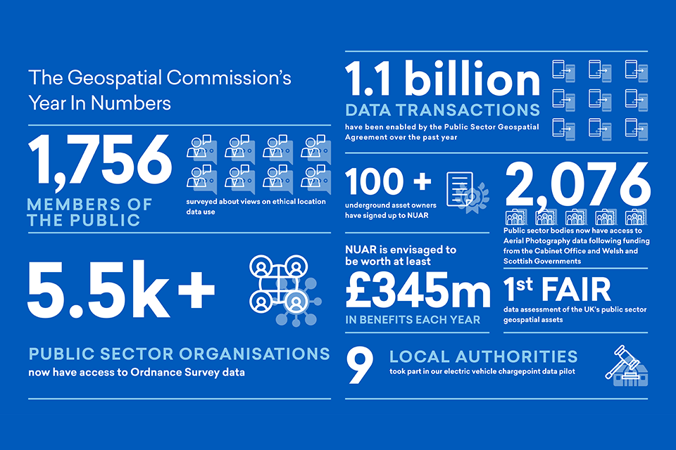
Geospatial Commission year in numbers
The Geospatial Commission’s year in numbers:
-
1,756 members of the public surveyed about views on ethical location data use
-
5.5k+ public sector organisations now have access to Ordnance Survey data
-
1.1 billion data transactions have been enabled by the Public Sector Geospatial Agreement over the past year
-
100+ underground asset owners have signed up to NUAR
-
2,076 Public sector bodies now have access to Aerial Photography data following funding from the Cabinet Office and Welsh and Scottish Governments
-
NUAR is envisaged to be worth at least £345m in benefits each year
-
1st FAIR data assessment of the UK’s public sector geospatial assets
-
9 local authorities took part in our electric vehicle chargepoint data pilot
Section 1 - Unlocking the power of location - the changing context
As government priorities evolve, location data is growing in significance.
- Supporting Levelling Up
- Helping meet Net Zero
- Driving Science and Technology
Location data to support: Levelling Up
Location data and applications will enable better public services across the UK and inform policy decisions that spread opportunity more equally.
Levelling up is a moral, social and economic programme for the whole of government that is dependent upon spatial data and analysis for effective delivery. The Levelling Up White Paper sets out how the government intends to spread opportunity more equally across the UK. The proposed programme of systems change will be rooted in evidence demonstrating that a mix of factors is needed to transform places and boost local growth. Spatial data and modelling are vital components.
Location data allows policy-makers to consider macro to hyper-local issues at a geographic level; it informs national and local-level planning and decision making. Effective use of location data can help target investment into commercial geospatial innovations across the UK, improve the opportunities for our towns and high streets, grow our regional skills and capabilities, and support the UK’s transition to a greener society.
As part of this, access to foundational location data is important to enable effective delivery of public services across the UK. The Geospatial Commission provides, through commercial agreements, a single access point for the public sector to core geospatial datasets. This includes:
- The Public Sector Geospatial Agreement (PSGA), which is a £1billion, 10 year contract with Ordnance Survey for world-class, foundational location data that underpins the effective and efficient delivery of public services
- The Postcode Address File, which provides the public sector with access to Royal Mail’s address data
- The Aerial Photography GB (APGB) contract, which supplies the public sector with aerial imagery that supports a range of policy and operational areas, from emergency response to monitoring and managing environmental impacts
The Geospatial Commission works closely with teams and organisations across the UK, including in all nations, to make sure the opportunities provided by effective use of location data are seen and understood by all. Examples of live programmes are our National Underground Asset Register currently rolling out in North East England, London and Wales, the National Land Data Programme that is running pilots in Devon, Northern Ireland and the West Midlands and our support for innovative geospatial companies through Location Data Scotland.
Case study: DLUHC Spatial Data Unit
High quality, timely, and robust local data and analysis is central to the UK government’s levelling up agenda. Better data will improve our understanding of local economic, social and environmental contexts, inform policies to ensure opportunity is more equally spread across the UK, and help us to monitor and evaluate the impacts.
The Spatial Data Unit in the Department for Levelling Up, Housing and Communities (DLUHC) was established following the government’s Levelling Up White Paper. The Unit supports the levelling up agenda by transforming the way the government gathers, stores, and uses subnational data to underpin transparent and open policy making, and delivery decisions.
The Spatial Data Unit works across national government and with local partners, and has four key areas of focus:
- Telling the story of place by building up spatial analysis and the data and tools required to understand places across the UK and support levelling up mission delivery and deep dives with local areas
- Improving subnational data to better understand local economies and communities, as well as mapping and tracking what government spends at a local level
- Improving data capability to ensure government has the right tools and skills to deliver the levelling up agenda at scale and at pace.
- Applying geospatial data science by assessing new data sources and tools to produce innovative analysis to support levelling up delivery
The early work of the Unit is helping support levelling up in local areas across the UK. Blackpool is one of the UK’s most iconic seaside towns but has eight of the ten most deprived neighbourhoods in England. In collaboration with local and national leaders and decision makers, as well as data and analysis teams, the Spatial Data Unit’s work helped set out the challenges and opportunities for the local area, informing the most effective approaches for levelling-up.
This work was central to a support package that was announced to help level up Blackpool, developed by government, local leaders, businesses and community groups as part of a new strategic partnership. The package includes a crackdown on rogue landlords and a transformative regeneration programme to create beautiful new homes and boost tourism in the area.
As the Spatial Data Unit builds to full capability, it will continue to provide the data and analysis for places, and work across government and with local partners, to support levelling up.
Location data to support: Net Zero
Location data and innovation will support system wide structural change, helping deliver the efficiencies and environmental outcomes needed for the UK to drive down emissions and meet its climate change objectives.
The UK has already taken bold steps towards Net Zero and this year outlined further strategic investments to reduce greenhouse gas emissions. Building on the Prime Minister’s ‘Ten Point Plan for a Green Industrial Revolution’, The Net Zero Strategy, Heat and Buildings Strategy and British Energy Security Strategy set out an ambitious plan to create new jobs, develop new industries with innovative new technologies and become a more energy secure nation with clean green British energy. This ambition was showcased to world economies through the UK’s Presidency of COP26, hosted in Glasgow in November.
Delivering UK climate policy ambitions will require system-wide change; UK infrastructure will need to adapt across power, heat and transport networks. As set out in the Net Zero Strategy: “This change must be designed in a systemic, geographically targeted way with appropriate local governance and delivery structures, which consider the complex range of interacting social, economic and demographic factors.” To support this, we need to develop new capabilities to provide evidence and insight to decision makers, highlighting dependencies and trade-offs within social, environmental and economic systems, and demonstrating the multiple impacts of proposed policies.
Through our programmes, we are unlocking location data to support this system change. Our National Land Data Programme will demonstrate how enhanced spatial modelling capability can inform land use scenario planning, enabling better decisions about how land is used to meet Net Zero targets while balancing competing demands. This year we will develop our priorities for transport location data improvement, focussing on an electric vehicle chargepoint infrastructure discovery project, working with local authorities to explore how location data can support the optimised planning of charge points and situating the location data opportunities in the context of wider electric vehicle rollout.
Case study: Dynamon
There is a growing awareness that our approach to economic growth must also protect the environment. The government has committed to achieving Net Zero by 2050 (pdf, 1,361 KB), but the transport sector remains the largest emitting sector in the UK. The government’s Transport Decarbonisation Plan, published in 2021, sets out the government’s commitments and the actions needed to decarbonise the entire transport system in the UK. Realising this ambition depends on us making the transition to new modes of transport, and location data can help drive the innovation to get us there.
Dynamon is a UK data analytics company and one of the Geospatial Commission’s seven transport competition winners. Dynamon has developed tools, built on advanced data analytics and AI, to help the commercial transport industry transition to a sustainable future with smarter fleet procurement. Their tools enable fleet procurement teams to precisely forecast the performance of different vehicle technologies within their specific operations to identify the optimum solutions that minimise cost and environmental impact.
Zero data analytics tool
Dynamon’s web-based data analytics tool, ZERO, helps commercial transport companies optimise their transition to zero-emission vehicle (ZEV) fleets. ZERO enables fleet teams to identify the optimum ZEVs and charging infrastructure based on their unique operation and depot electricity constraints. Insights provided by ZERO are aimed at significantly de-risking the transition to ZEV fleets and helping to accelerate the phasing out of fossil fuel vehicles in commercial transport operations.
ZERO works by combining geospatial datasets (fleet telematics data, terrain data, weather data, traffic data, charge point data) with ZEV performance data obtained from Dynamon’s industry leading ZEV testing program. ZERO can forecast real-world ZEV performance within specific fleet operations and identify the required charging infrastructure to ensure a ZEV fleet can perform the same operation as a previous internal combustion engine fleet. They have worked with other large companies, including Royal Mail and Sainsbury’s, to gather ‘real world’ fleet data.
Location data to support: Science and Technology
Location data both informs and is enhanced by the application of science and technology to tackle an increasingly complex set of system challenges that are top of the global policy agenda, from supply chain dynamics to the best use of our finite land and marine resources.
The UK has historic and current strength in science and technology, and ensuring we continue as a world leader in this area is at the heart of UK policy. Science and technology is a key pillar of the government’s Integrated Review to support the UK’s future economic, national and environmental security. The government’s Innovation Strategy outlines that innovation is essential to enabling the UK’s future prosperity and achieving UK objectives as a force for good on global challenges around climate, biodiversity, prosperity and security. The National Science and Technology Council (NSTC) supported by the Office for Science and Technology Strategy (OSTS) has been set up to apply science and technology strategically and embed it in UK government policy and decision making.
The application of science and technology is important because of its power to help us tackle complex problems. This has been evident during the coronavirus (COVID-19) pandemic where the UK’s strength in science helped guide our decision making. Today cutting edge technology, such as artificial intelligence and machine learning, can be applied to new data that is increasingly available as digital expands into our world, providing us with new tools to tackle some of the biggest problems we face.
Location data plays a key part in this technological evolution. Location is an attribute that is increasingly attached to data. This means there is more location data to use, and we can increasingly link different data sets together by using their common location. This drives new insights about where and when things have happened and it allows us to model and predict current and future events with increasing accuracy, for example, to support journey planning, to understand the changing environment, or to assist with battlefield planning and manoeuvres.
The Geospatial Commission recognises the importance of location data in the continuing science and technology revolution, and will enable its application to seize the opportunities and meet the challenges the UK faces today, through advocating for the necessary capabilities and people within organisations and showcasing the value and application of advanced spatial modelling in helping solve the complex problems of today and tomorrow.
Science and Technology case study: Earth Observation
Marine geospatial data for autonomous vessels
Geospatial data is critical for enabling autonomous/semi-autonomous vessels at scale. Successful navigation relies on datasets, such as real time updates on weather and surface currents, and high resolution gridded bathymetry data, that provides a definitive view of the seabed in coastal waters.
Built by a marine research non-profit organisation with support from IBM, the Mayflower Autonomous Ship (MAS) is designed to provide scientists with a flexible and cost-effective platform for collecting critical data about the health of the ocean and further the technological development of marine autonomous systems. By assimilating data from a number of sources, MAS’s AI captain constantly assesses the ship’s route, status and mission, and makes decisions about what to do next.
UK Hydrographic Office (UKHO) geospatial data has supported the first journey of the MAS across the Atlantic. UKHO has worked with the MAS team to explore how the use of the newly emerging S100 Electronic Navigational Chart (ENC) data standards can be used to safely sail an unmanned autonomous vessel. When MAS set sail for her attempt across the Atlantic, she used the UK Hydrographic Office’s S101 (new ENC), S102 (gridded bathymetry), S104 (tidal height data) and S111 (surface current data), to sail safely out of Plymouth. This marked the first time globally that S100 data has been used on an autonomous surface vessel.
Section 2 - Mission Updates
The UK Geospatial Strategy has a vision for a coherent location data framework by 2025, delivered through the Geospatial Commission’s four strategic missions. This section provides an update on progress against the Strategy commitments and plans for the year 2022/23.
Mission 1: Promote and safeguard the use of location data
In order to unlock the power of location, we need to provide an evidenced view of the market value of location data, set clear guidelines on data access, privacy, ethics and security, and promote better use of location.
What we have done
Location data ethics dialogue and national survey
To benefit from the widespread use of location data it must be used in a way that mitigates concerns and retains public confidence. In December 2021, we published the findings of our public dialogue on location data ethics, which opened an informed conversation with 85 members of the public to gather evidence about public perceptions of location data use. The project was a partnership with public dialogue and data specialists Sciencewise, Traverse and the Ada Lovelace Institute and an expert Oversight Group provided support and quality assurance from a diversity of views.
In February, we published the findings of our nationally representative survey on location data ethics, which provided further insights into the public’s perception of location data and created a baseline that will enable us to establish and test trends through future surveys. Many of the findings reflected those made in the public dialogue and have provided an evidence base on which we are developing further work.
Opportunities for location data to support better UK transport
We published ‘Positioning the UK in the fast lane’, a report outlining the significant location data opportunities for better UK transport. The report highlighted the important role location data and technologies play for the improved operation of transport services and the delivery of new networks and transport corridors. The report outlined key common themes and cross-cutting challenges, based on six transport use cases, where geospatial products and services could unlock the greatest benefit:
- Treating mobility as an interconnected system: We will need to have a common location data framework for defining our transport networks
- Data interoperability and standards: Standards must be implemented in the way that transport location data is collected, stored and managed
- Making data more findable and accessible: Data must be made more discoverable and easier to access
- Improving data reuse: Data is rarely useful for a singular purpose and must be made available for reuse where possible
- Enabling greener modes of transport:We will need to transform the sector in order to meet the UK’s commitments around achieving Net Zero by 2050, and Scotland’s commitments to achieve Net Zero by 2045
- Unlocking the potential for data-driven innovation in transport: Organisations will need access to capital, skills and ideas, as well as a smart and stable regulatory framework to support data-driven innovation
What’s next
Location data ethics
The UK’s Geospatial Strategy included a commitment to publish a paper with informed views on how to unlock value from location data while mitigating ethical and privacy risks, ensuring compliance with legal principles and retaining the trust of citizens. The paper is relevant for all UK organisations that use location data and published in June 2022. It contributes to Pillar 4 of the National Data Strategy, helping ensure that data is used responsibly and Mission 2 of the National Data Strategy, securing a pro-growth and trusted data regime in the UK.
Our public engagement found that many citizens recognise and support the use and reuse of their location data to provide individual conveniences and public goods but that this support is conditional. Our published views aim to provide organisations with the building blocks to build public trust and maximise confidence in this system of use and reuse of data, and as a result increase the public’s willingness to share their location data.
The paper uses three ethical foundations - ABC - to help organisations consider how best to realise these opportunities. They have been informed by engagement across the geospatial ecosystem and wider government data ethics policy work, including by the Centre for Data Ethics and Innovation and the Central Digital and Data Office.
- Accountability. Governing location data responsibly, with the appropriate oversight and security
- Bias. Considering and mitigating different types of bias, and highlighting the positive benefits of location data
- Clarity. Being clear about how location data will be used and the rights of individuals
Guidance on the investment case for location data improvement
Assessments of location data projects have generally struggled to isolate, attribute and value the benefits of data use. Location data is typically one of multiple inputs that influence the benefits generated and produce benefits beyond its initial use and purpose, meaning its full value is not well understood, articulated, or estimated. It can therefore be difficult for decision makers to understand and compare the benefits of one investment over another.
To address this issue, the Geospatial Commission committed to publishing guidance on measuring the economic, social and environmental value of public sector location data interventions, improving and bringing consistency to the way that the case for investment into location data improvements is understood and assessed. Whilst the guidance focuses on public sector investments, we expect the principals and scope included will also be relevant for both the private sector and other types of data, beyond location.
Property data
The UK Geospatial Strategy identified housing and local planning as an opportunity area, where data-driven innovation in the land and property sector has the potential to support increased transparency, efficiency and productivity.
In spring 2023, we plan to publish our emerging views on the key opportunity areas across the ecosystem to unlock greater value from location data relating to domestic and non-domestic properties. This project will consider how improved geospatial data can drive better decisions throughout the property lifecycle, from planning, construction, conveyancing and building maintenance to demolition and regeneration. We will develop an evidence base for future actions, drawing on the breadth of experience of industry, academia and the public sector and working with our Partner Bodies.
Case study: Valuation Office Agency (VOA)
Geospatial has been placed at the heart of the VOA’s (executive agency of HMRC) business transformation to improve the efficiency of the organisation, adapt to growing business needs and the expanding need for valuations and improve customer service for every home and business occupier in England and Wales.
It is a significant transformation supporting over 3,000 VOA employees who will benefit from the new system empowering them to be up to three-times more productive in some of their daily activities, adapting to the growing business needs.
The number and complexity of data-sets and visualisations have never been mapped on a single solution before. More than 60 layers of data were collected from dozens of organisations to create simple visualisations and obliques. These provide real-world views rather than flat maps allowing valuation officers to:
- See interactive historical views to get a sense of the area over time to see if it is improving or declining
- Measure a building from a plan, digitise it and place it on a map in the right place and context, to show a location in the context of a business process, driving an accurate valuation calculation
- Zoom in to view streets, buildings and even floor plans for extremely accurate results; the outcome is faster, more reliable valuations, improving efficiency and the customer experience
Due to built-in custom application programming interfaces (APIs), valuation officers can easily focus on the most relevant data in order to complete their valuations faster.
Mission 2: Improve access to better location data
We will streamline, test, scale and support the development of new and existing location data ensuring it is findable, accessible, interoperable, reusable and of high quality.
What we have done
National Land Data Programme pilots
Land is the UK’s most valuable asset, worth £5.4 trillion in 2017. This finite resource faces competing demands including from housing, planning, infrastructure, farming, food production, carbon sequestration, flood protection, habitat creation, underground mineral and geothermal resources. Where and how land is used needs to be carefully considered to ensure competing priorities are taken into account and land is used most effectively towards critical government priorities, including working towards Net Zero, local regeneration and meeting infrastructure investment targets.
In September 2021 we announced the National Land Data Programme, working with pilot sites in Devon, the West Midlands and Northern Ireland and supported by a steering group with relevant departments (Defra, DLUHC, BEIS, DfT and ONS). Our partners, the British Geological Survey (BGS), have worked with teams in pilot areas to understand where land use data is and is not serving decision making, with input from local authority planners, housing market assessment officers, analysts from the Environment Agency and Homes England, land agents in Devon and many more. In parallel, we have also commenced work with Ordnance Survey on a land use data model, which will help align existing local datasets that describe land use, land cover, land capability and land constraints.
Space and Geospatial procurement framework
Public sector demand for critical location data and associated services is increasing, although a lack of collaboration between public bodies in accessing this data is likely to reduce the value that geospatial data can bring to public services. Exploring better public sector procurement and access mechanisms will drive more impact from location data in the UK economy by providing a more efficient route to market and encouraging competition and innovation to meet requirements.
We have worked closely with the Crown Commercial Services (CCS) to create a Space-Enabled and Geospatial Services Agreement. Launched in October 2021, the agreement raises public sector awareness of capabilities within the geospatial and space markets and provides a simple and efficient route to a wide range of competition. It has been set up to onboard new suppliers (including SMEs) throughout its lifecycle and to avoid restrictive definitions, leaving the scope open to innovative and emerging capabilities from the market. So far, 72 suppliers have entered into or completed the onboarding process. Drawing on best practice from our existing public sector wide contracts, such as the Public Sector Geospatial Agreement (PSGA) and Aerial Photography Great Britain contract, we have worked with CCS on the terms and conditions of the agreement to ensure data procured via this route is as FAIR as possible.
Electric vehicle charge point infrastructure project
We launched a discovery project to explore how location data can be better utilised to support planning and delivery of electric vehicle charge points by local authorities. The project included deep dive workshops with local authorities in England to identify challenges and opportunities for better use of location data in the rollout of electric vehicle charge point infrastructure. The project identified opportunities for greater collaboration, data sharing and easier access to better data, including around off-street parking, energy distribution networks, current charge point locations and land ownership.
Rollout of the National Underground Asset Register (NUAR)
A significant proportion of our utility, building, and transport infrastructure is buried underground, including circa 4 million kilometres of pipes, cables, telecoms, and sewers. An estimated 4 million holes are dug every year to access buried utility networks for repairs, upgrades and installations. This busy and often unseen environment suffers from an estimated 60,000 utility strikes per year, leading to injury, project delays, and disruption to traffic and local economies. Accidental strikes on underground assets are estimated to cost £2.4 billion a year in direct and indirect costs. Whilst data on underground assets is freely available for certain groups, obtaining it requires contacting multiple sources, with the data provided in different formats, scales and to varying timeframes.
NUAR is a government-led programme aimed at streamlining the data-sharing process, reducing the risk of potentially lethal utility asset strikes and promoting more efficient management and maintenance of underground assets. It will be a single, secure data-sharing platform on the location and condition of underground assets that will provide an interactive, standardised digital view of the underground assets in a given location.
In 2021-22, following the success of our pilots in North East England and London, we appointed our delivery partner, Atkins, and have started work on the production platform. Together with Atkins and their supply chain - Ordnance Survey, 1Spatial and GeoPlace - as well as the Greater London Authority and Welsh Government, we are now working with utilities, telecoms, public sector bodies and other owners of underground assets from across the UK to deliver this high value initiative.
Since September 2021, over 119 organisations [footnote 2] across the energy, water, telecoms and local authorities have signed up to NUAR by entering into a Data Exploration Agreement (the initial data sharing agreement which enables the NUAR team to access and map their data, prior to it being ingested into the NUAR platform). 35 organisations have also signed the Data Distribution Agreement (the enduring agreement allowing NUAR to share their data with 3rd parties on an ongoing basis)
FAIR assessment of UK public sector geospatial assets
In 2021, we undertook the first comprehensive assessment of the UK’s core geospatial data assets that are managed by our Partner Bodies against FAIR principles (Findable; Accessible; Interoperable; Reusable). This was published in our report: How FAIR are our national geospatial data assets? Whilst this initial assessment only considered the assets held by our Partner Bodies, findings are indicative of the wider UK geospatial ecosystem.
The UK’s geospatial data is supplied by a range of organisations originally established to provide different functions, all operating under distinct governance, policy remits and business models. This results in an organisation-centred approach to geospatial data improvement in accordance with individual organisational priorities, where cultures, capabilities and appetites for data improvement can diverge. The report concludes that despite widespread, in-principle support for FAIR principles, there is variation in their adoption with improvements not always integrated in a way that brings the greatest benefit for the UK overall.
As part of this programme, we have published a register of the core geospatial data standards that should be used for the exchange of geospatial data between organisations. There are more than 1,000 published standards related to geospatial data, reflecting the diversity and wide-ranging nature of geospatial as a topic in itself. Working with our Partner Bodies, we undertook a consultation with users to establish the core standards that are in use and should be adopted in the absence of good alternatives. To ensure the register is maintained and regularly updated, we established an open governance mechanism with the established BSI Technical Committee for Geospatial Standards, in collaboration with the Data Standards Authority, to ensure consistent approaches for the use of data standards more widely.
Expanding access to property attribute data held by the Valuation Office Agency
In September 2021, the government announced an intention to introduce a new legislative data sharing gateway to enable property attribute data held by the Valuation Office Agency to be made more accessible to the public and private sector. Expanding access to this property data will support economic growth, delivery of better infrastructure and essential government functions, including supporting analysis of existing and new housing supply, insurance companies to provide more competitive quotes and the energy sector to develop higher efficiency heating systems in support of Net Zero.
Better coordination of public sector access to mobility data
Mobility data (in particular, anonymised and aggregated mobile phone data) is a unique and innovative location data source that is increasingly used across the private sector and has been critical for monitoring and responding to the COVID-19 pandemic due to its high frequency and low latency at local geographies. Mobility data will be increasingly vital to the planning, delivery and evaluation of critical public sector operations and policies. It will continue to be sought to deliver future government priorities, such as economic recovery, infrastructure planning and monitoring levelling-up objectives. In 2021, we initiated a cross-government group to understand opportunities to align requirements for this data and to evaluate the case for collective access.
What’s next
Building the UK’s land use data capability
In 2022/23, the National Land Data Programme will continue to work with relevant departments and in the three, established pilot areas to:
- Demonstrate the value of enhancing the UK’s spatial modelling capability to inform land use scenario planning
- Deliver a blueprint for the capability improvements required to improve spatial modelling for land use strategy, including: data, technologies, skills and partnerships
We will publish a report in summer 2023 which consolidates our findings, establishes a case for change and sets out recommendations.
Improving public sector access to Earth Observation (EO) data
In the UK’s Geospatial Strategy, we committed to exploring the rationalisation of public sector procurement of EO data and services. EO/remote sensed data derived from a range of capture platforms are currently used extensively by the UK public sector, with circa 2,000 organisations accessing aerial photography products via the Aerial Photography GB (APGB) agreement. As the market acquisition of EO-derived data across a range of platforms, resolutions and spectra has proliferated, there is growing demand for the unique insights that these provisions can contribute to policy areas such as environmental monitoring, land use planning and emergency response. Moreover, there are efficiencies that can be realised on access models for openly available remote sensed datasets that are not easily accessible to organisations without in-house remote-sensed data analysis capability.
Collective access models deliver efficiencies on disparate, duplicate data and service procurements in the public sector by implementing a ‘buy once, use many times’ approach. Through leveraging collective purchasing power for data and services in demand across the public sector, access to high quality data can be negotiated on terms that enable onward sharing and dissemination of the data and derived insights, ensuring the access model is as FAIR as possible. A collective access model for EO has the potential to unlock significant additional value through:
- Providing access to a broader spectrum of data offered through space and aerial-based remote sensing for current use cases
- Delivering the best possible value for money through increased public sector collaboration and further commercialisation of innovative data and services
- Sharing knowledge and insight across the public sector that will help the realisation of greater value, including across newer policy requirements and the wider public sector where there are fewer EO-specific analytical capabilities
To establish whether there is a case for a collective access model that includes further remote sensed datasets, we have undertaken a co-funded piece of research with the Satellite Applications Catapult into the public sector demand for satellite EO-derived data and the barriers to full uptake of open and commercial datasets. This has identified the key barriers to the public sector’s wider adoption of EO data and high-level suggestions for interested parties to consider to address them. The barriers highlighted include:
- Varying levels of technical understanding of EO data and service capability across public sector bodies
- Challenges in ensuring public sector understanding keeps pace with maturing technical developments in the EO market
- Establishing a robust case for investment
- The perceived high costs of certain market offerings, such as high-resolution EO data.
The details are set out in the Satellite Application Catapult’s summary report that has recently been published.Based on the findings of this research, we will work with public sector partners to pilot access to commercial, EO-derived high resolution data to better understand whether collective procurement access will help to overcome these barriers and realise additional opportunities.
Local authority electric vehicle chargepoint infrastructure data
We will publish the insights from our electric vehicle charge point location data discovery project by the end of 2022 as part of our ongoing transport location data programme. We will continue to engage with local authorities, central government, the Office for Zero Emission Vehicles (OZEV) and other relevant stakeholders to test the findings we have made and identify areas for future intervention.
Roll out of the National Underground Asset Register
We will continue our work on the Minimum Viable Product (MVP), rolling out NUAR first in North East England, Wales and London. The initial platform release will aim to include the highest value data sets for each region as well as core functionality, allowing the development team to get feedback from real users to further improve the service. It will then be enhanced, both in terms of functionality and the data it contains while being rolled out to the remaining regions in England and to Northern Ireland. We are conducting a public consultation seeking views on the merits of supportive legislation and our current thinking to date on the future operating model for the service and will publish the government’s response later this year.
UK-wide foundational geospatial data
Currently, the Public Sector Geospatial Agreement (PSGA) provides access for the whole of the public sector to a range of foundational data covering Great Britain. There are a number of organisations that have a UK-wide remit and therefore require UK-wide data. Following initial discussions with Ordnance Survey Northern Ireland and some current users, we are exploring the case for potential efficiencies and opportunities that could be realised through the development of a comparable arrangement to the PSGA for Northern Irish data.
FAIR data improvements
The National Data Strategy has advocated the adoption of FAIR principles to improve the value of data, and the Data Standards Authority (DSA) is considering opportunities and incentives to increase adoption of standards across the wider public sector. We will work with the Central, Digital and Data Office and the Data Standards Authority to ensure that FAIR location data is consistent with the approach to wider data standards and data improvement priorities. We will continue to promote the application of FAIR data principles to geospatial data, taking steps to support consistent practices across the public sector geospatial agencies.
Case study: Public Sector Geospatial Agreement (PSGA)
In April 2020, the Geospatial Commission signed a new, 10-year contract with Ordnance Survey (OS) to provide the UK public sector with free at the point of use access to foundational location data.
In our 2021/22 Annual Report, we highlighted the PSGA commitment to launch improved currency data on Buildings and Structures within OS MasterMap, reducing the time between when a building or structure is completed to its availability as OS data. OS data has also improved in currency for other critical features of the built environment including new public roads, railway routes and major flood defences. As a result, all of these feature types will be maintained on a three month currency. The improved data currency has been made available as part of the OS MasterMap Topography Layer since its release in July 2021.
Beyond the commitment in last year’s annual plan the PSGA has continued to perform strongly. The PSGA membership has grown by 3.6% overall from 5,626 public sector organisations in 2020/21 to 5,836 in 2021/22, all of who have benefitted from enhanced data and improved access to the core data that OS maintains on behalf of the Crown. The PSGA is supporting wider use and innovation across both the public and private sectors through improved data and access. Some notable highlights from the last 12 months include:
-
New errors and omissions tools have been developed and made available to all OS data users including for address data for the first time. This facility enables continuous data quality improvement of the UK’s national location data asset
-
The Research and Development programme continued to complete pure research and applied research in a series of themes, including security and resilience (Position, Navigation, Timing resilience), urban planning and insight (street level PSGA geography), sustainability (land potential and COP26 peatlands demonstrator), and introducing new efficiencies and enhancements throughout the data capture and production process
-
The public sector has benefitted from having access to the OS’ world leading geospatial experts to support the building of geospatial capabilities across the public sector through the mapping for emergency provisions where OS teams have responded to seven Mapping for Emergency (MfE) requests this year. These have ranged from COVID-19 support to weather-related emergencies providing data, analysis, and expertise to support decision making in times of critical response
- A number of public sector teams have also had geospatial data experts deployed from OS within their data science teams supporting delivery of projects that include development of specific routing analysis for a range of public sector applications as well as working with stakeholders to develop new insights and spatial analysis approaches in relation to health and crime
- A number of public sector teams have also had geospatial data experts deployed from OS within their data science teams supporting delivery of projects that include development of specific routing analysis for a range of public sector applications as well as working with stakeholders to develop new insights and spatial analysis approaches in relation to health and crime
Data made available through the PSGA, when combined with a range of other data, has helped support the UK’s response to the Ukrainian refugee crisis. In Scotland, the Scottish First Minister announced the Warm Scottish Welcome Scheme on 19 March, supported by data and analytical teams across government. The GI-SAT team in the Scottish Government provided expertise by mapping the expected final location of Ukrainian visa holders where their address is known at both an intermediate geography and local authority level, combining the data with local authority school capacity data to identify potential pinch points in the relocation process. This analysis can also be utilised to inform, for example, the location of potential visa application centres.
In 2022/23 the PSGA will deliver:
- OS Select + Build and OS National Geographic Database (NGD) API – Features milestones that will change the way in which OS data is accessed, moving away from a fixed specification product, instead breaking the data down into component parts which will allow users the freedom to use elements of the data that they need in more agile and innovative ways. This will provide higher quality, more usable data to geospatial teams across government and local authorities ensuring that geospatial data is used in early project planning stages
- New NGD data will be delivered across multiple themes, with enhancements to areas such as land cover and transport data
Mission 3: Enhance capabilities, skills and awareness
Develop more people with the right skills and tools to work with location data, across organisations and sectors, to meet the UK’s future needs and support global development.
Growing the Government Geography Profession
In addition to expertise in the analysis and use of location data, members of the Government Geography Profession (GGP) often have parallel policy, scientific, engineering, analytic and digital skills that are enhanced by the application of a spatial perspective. Over the last year the GGP, which is housed within the Geospatial Commission, has grown its membership and cross-cutting networks, including formalising working-level agreements with the Royal Geographical Society (with the Institute of British Geographers) and the British Cartographic Society. The innovative work of the GGP’s dedicated and talented members was celebrated at the GGP Awards in May, and the annual GGP conference in November with the theme ‘Geographical (in)equality’.
Geospatial skills assessment
We published the Demand for Geospatial Skills Report in June 2022. Geospatial skills are transforming in relevance and application, becoming part of a wider ecosystem of data and digital skills, and this report has developed our understanding of this complex ecosystem. We know there are many sectors with a high demand for core geospatial skills, as well as those where the demand for geospatial skills does not yet match the opportunity that exists. There is also increasing demand for the digital skills needed to create, manage and use location data as a digital asset, which correlates with increasing global demand for digital skills, which is outstripping supply. These findings support the government’s existing prioritisation of digital skills as part of the National Data Strategy.
Digital maps in secondary schools
Ordnance Survey continues to develop its skills offering through the Education Plan that is part of the Public Sector Geospatial Agreement (PSGA). Last year the OS expanded the provision of the Edinburgh University Digimaps for Schools by offering free access to certain primary and secondary schools in England for two years. This enables underperforming schools, with an Ofsted rating of 3 or 4, to access digital maps as a learning resource at no cost, supporting students to develop their digital location data skills and understanding. This scheme has the potential to reach over 1,900 schools and hundreds of thousands of pupils.
So far, Ordnance Survey has run 92 events to provide 2,029 teachers with knowledge on using mapping and teaching geography for primary level and using geographic information system (GIS) at secondary level, and continues to create online materials, including the award-winning guide for teaching geography for primary schools. These online materials saw a 20% increase in downloads over the previous year.
Showcasing UK’s geospatial expertise overseas
The Geospatial Commission continued to support the work of the UN Expert Committee Global Geospatial Information Management (UN-GGIM), representing the UK on the High Level Group for Integrated Geospatial Information Framework leading work on their communication strategy.
We have supported the UK’s leadership at COP26 with an event in collaboration with the Knowledge Transfer Network (KTN) looking at how location data from the Partner Bodies can support achieving the UK’s national Net Zero goals. We opened the UK showcase day at the Cambridge Conference, organised by Ordnance Survey, which invited national mapping providers from around the world. Over the last year, the Geospatial Commission represented the UK by speaking at multiple international conferences, both online and in person, including in Singapore, India, Australia and the Netherlands.
What’s next
Embedded geospatial data science expertise
To solve complex problems with location data we need people with the capability to create, manage and apply geospatial data effectively. Through the Public Sector Geospatial Agreement (PSGA), geospatial data scientists from Ordnance Survey have begun to be embedded within government teams to support delivery of public sector programmes. So far, this expertise has supported the government’s COVID-19 pandemic response, the continued roll-out of digital infrastructure, analysis and insight to support the delivery of crime and disorder strategy, and the delivery of the Birmingham 2022 Commonwealth Games.
The deployment of this expertise has not only supported the delivery of key projects, it has provided the basis for developing enduring, in-house capabilities. The capability has so far been focused on those areas with an immediate, time critical requirement for delivery. This year, we will refine the allocation of geospatial expertise through the PSGA, including exploring running a competitive bidding process for public sector bodies to propose placements that build capability as well as creating innovative and repeatable solutions to public sector challenges.
Year 10 Geospatial Virtual Work Experience
Through the PSGA, Ordnance Survey will deliver a Year 10 Geospatial Virtual Work Experience programme, launching in July, aiming to reach up to 500 year 10 students across Great Britain to increase their awareness of the benefits of a geospatial career. Throughout the programme the students will be introduced to the latest technologies such as drones, satellites and artificial intelligence, as well as some of the core skill sets used by geospatial professionals. The programme will include live sessions with Ordnance Survey experts in which they will share their real-life experiences of using geospatial expertise to tackle global issues like sustainability and the national response to the COVID-19 pandemic.
International leadership
In the international sphere, the Geospatial Commission will continue to promote the power of location data and UK’s geospatial expertise globally through demonstrating leadership as part of the UN’s geospatial work programme. We will continue to set direction for the communications strategy for promoting the UN Integrated Geospatial Information Framework. We will also be a member of the international advisory board for the UN World Geospatial Information Congress (UNWGIC) 2022, held in Hyderabad in India, in October 2022. Diversity within the geospatial community has long been recognised as an area that needs improving. We will explore options for the UK to lead on supporting increased diversity in the global geospatial community.
Case study: Centre for Doctoral Training
Huge amounts of geospatial data and information about location is created daily across a wide range of systems around the world, which has the potential to unlock significant economic benefits. To achieve this, the UK needs a new generation of engineers, scientists and practitioners, with the knowledge, innovation and technical skills, able to work with location data to transform our understanding of an increasingly complex digital world.
Established in 2018, as a collaborative partnership between Newcastle University and the University of Nottingham, the Centre for Doctoral Training (CDT) in Geospatial Systems, is an internationally recognised centre of excellence of doctoral training in Geospatial Systems. Funded under the Engineering and Physical Sciences Research Council (EPSRC) CDT `Towards a Data Lead Future’ priority topic, nurturing these future leaders in cutting edge data skills will enable the UK to maximise the economic benefits of the open geospatial data revolution.
Working with Industry Partners and government, the programme and interdisciplinary research themes have been informed through consultation with over 40 CDT industry partners. These partnerships with the global geospatial industry, applied user base, professional bodies and the public sector, play an important role in ensuring the creation of the next generation of geospatial engineers, scientists and practitioners. The CDT students receive technical training around five core geospatial themes: spatial data capture and interpretation, statistical and mathematical methods, Big Data spatial analytics, spatial modelling and simulation, and visualisation and decision support.
Maximising the benefits of cutting edge technologies, the program aims to develop a national cohort of internationally recognised research excellence in Geospatial Systems. Working with the geospatial industry, the programme aims to attract students from a wide range of backgrounds, to be part of a research training environment. Students will develop technical skills and industry knowledge, which can be applied in solving big world issues in areas such as Smart Cities, Urban and Infrastructure Resilience, Spatially Informed Mobility, Spatially Engineered Energy Systems, and Social Inclusion and Healthy Living.
Mission 4: Enable Innovation
Maximise the commercial opportunities for innovation and promote market-wide adoption of high-value emerging location technologies.
What we have done
Invested in innovative, commercial solutions to transport location data challenges
We established a Transport Location Data Competition with Innovate UK in 2020 to bring together public sector transport data challenges with commercial innovators and deliver novel solutions. The competition targeted major transport challenges, including overcoming transport network siloes, increasing efficiency, mitigating active travel safety risks and tackling logistic challenges in the supply chain.
Following the development of feasibility studies during Phase 1, we launched Phase 2 in May 2021, selecting seven of the most innovative and commercially viable projects, then supporting the rapid development of innovative location data solutions over an eight month period between August 2021 and March 2022.
These solutions offer large scale potential benefits to the UK transport sector as well as the wider economy, environment and society. Additionally, this phase of the programme has helped SMEs grow, created jobs, and unlocked public and private sector location datasets which have enabled further innovation. To celebrate this success, we ran a showcase event in April 2022 which provided an opportunity to highlight and demonstrate the transformative benefits the innovative location data solutions can deliver to an audience of potential public and private sector customers. These benefits ranged from reducing hybrid vehicle emissions by 23%, to saving local authorities £20 million per annum by automating transport surveys.
Supported Scotland’s geospatial business cluster
In partnership with the Scottish Government and Scottish Enterprise, we have continued to support the development of Location Data Scotland (LDS), which is a facility to connect geospatial innovators working in Scotland. A Location Data Scotland directory has been developed to create a community of more than 100 organisations in the geospatial market to raise their profile, find new customers and suppliers, increase collaboration with new partners and identify funding sources.
Additionally, an advisory group, composed of private and public sector organisations as well as academic institutions, has been set up to represent different community views and provide advice directly from industry experts to ensure the project capitalises on opportunities. Location Data Scotland has also agreed a strategic alliance partnership with CodeClan, Scotland’s Digital Skills Academy, to help bridge the digital skills gap in Scotland’s growing tech industry and boost the relationship with Scotland’s growing geospatial community to help tackle geospatial skills challenges.
What’s next
Quantifying the value of transport location data innovation
We will continue to monitor the projects from Phase 2 of the Transport Location Data Competition as they seek to realise the benefits that their solutions can deliver to the UK transport sector, providing an evidence base to inform our future strategic priorities. We will continue to help the Phase 2 projects by supporting conversations with potential customers, promoting their innovative location data solutions within government and providing guidance on procurement routes such as the Space-Enabled and Geospatial Services Dynamic Purchasing System.
Convening expertise on spatial modelling
The evolution of spatial modelling techniques open up new opportunities for the use of location data to solve key problems, including the assessment of trade offs in decisions about land use across the UK. We will bring together expertise to share capabilities on spatial modelling, to gain a better understanding of how to support the application of cutting edge mathematical and scientific techniques in order to use location data to solve key problems facing the UK.
The transport location data competition in numbers
The Transport Location Data Competition in Numbers:
-
Dynamon has identified 4.9m km driven each day by large fleets that could transition to zero emission vehicles
-
76% of rail geometry faults could be identified early by Thales’ automated rail geospatial observation system
-
£4m of investment was shared by the 28 winners of the transport competition
-
Ricardo’s geofencing app could reduce hybrid car emissions by 23%
-
Up to £20m per year could be saved by local authorities on manual surveys through Ngenius’ traffic surveying software
-
£2.4 million could be saved each year by using Hack Partners’ delorean dashboard to reduce the time spent investigating rail delays
Case study: Sustainable management of natural resources using innovative geospatial solutions
The use of geospatial data, in combination with innovative technologies such as artificial intelligence, can provide crucial insights to make better land use decisions enabling sustainable management of natural resources. As countries increasingly adopt Net Zero strategies, policy makers and organisations across the globe are faced with ever increasing questions about the current state, condition, value and sustainable use of their natural resources.
Global Surface Intelligence (GSI), an Edinburgh based geospatial SME, are using satellite imagery in combination with other data layers, for example mapping tools, GIS, Light Detection and Ranging (LiDAR) and ground reference data, to survey forests at large scale with high levels of accuracy to deliver analysis-ready data for commercial customers in the industry supply chain.
GSI were invited to join Ecometrica in a European Space Agency backed consortium called the Scottish Earth Observation Service (SEOS), a project that delivers a Vegetation Condition, Scotland (VCS) mapping and monitoring service to address environment and land-management issues to save time and money.
GSI provided accurate forestry surveys from which potential investors could build a valuation for specific areas of interest across Scotland. There was a high degree of innovation in combining satellite and LiDAR data to achieve the desired levels of accuracy. Maps were produced for five areas to demonstrate the key attributes of tree species and tree heights which are the essential components for the valuation models. The SEOS service was publicly launched on 4 May 2022 and reports are now available as well as bespoke surveys.
-
The Geospatial Commission works in partnership with a range of organisations, including its six public sector leading geospatial partner agencies: Coal Authority; British Geological Survey; HM Land Registry; Ordnance Survey; UK Hydrographic Office; Valuation Office Agency ↩
-
As of 20 June 2022 ↩