How FAIR are the UK's National geospatial data assets? Assessment of the UK’s national geospatial data assets (HTML)
Published 9 February 2022

© Crown copyright 2022
This publication is licensed under the terms of the Open Government Licence v3.0 except where otherwise stated. To view this licence, visit nationalarchives.gov.uk/doc/open-government-licence/version/3 or write to the Information Policy Team, The National Archives, Kew, London TW9 4DU, or email: psi@nationalarchives.gov.uk.
Where we have identified any third party copyright information you will need to obtain permission from the copyright holders concerned.
This publication is available at https://www.gov.uk/government/publications/how-fair-are-the-uks-geospatial-assets/how-fair-are-our-national-geospatial-data-assets-assessment-of-the-uks-national-geospatial-data-html

Kru Desai, Commissioner, Geospatial Commission
Foreword
Geospatial data is fast becoming one of the most important tools for understanding and acting on the challenges of our modern world. Across the globe, a country’s location data capability will soon be a key factor in its competitiveness and quality of life. But how good is the UK’s geospatial data? More to the point, how good does it need to be?
The power of location has always been an essential part of how we interpret our world. Whether it be a map or a list of directions, location has always played a key role in our survival as a species. Possibly the oldest example of location in use is a map that dates back to 25,000 BC and is engraved on a mammoth tusk.
Today, geospatial data has moved beyond the humble map. All of the UK’s critical national infrastructure - physical networks, utilities, core services and supply chains - now require geospatial data to function. With the advent of big data and the internet of things, geospatial data underpins new business models and informs decisions on almost everything in our daily lives.
The UK currently has some of the best geospatial data in the world but the pace of technological change and global challenges mean we need to do more. We must treat geospatial data as a strategic national asset if we want to see the further productivity gains it promises.
The issue is, we need a coherent national geospatial data system as the basis for our data economy - but our national geospatial data assets are maintained by a complex and fractured ecosystem. The diversity, scope and complexity of data sets presents a growing challenge - data sets cover many sectors, take many forms and are supplied by many organisations. A map of geology, a weather forecast, an aerial photograph, a classification of land use, the blue dot on your sat nav - it is all geospatial data. But it is not easy to fit these things together.
Yet the value of data increases immensely when data is combined in new ways. We want to ensure our strategic national geospatial assets are optimised for this. Data must be Findable, Accessible, Interoperable, Reusable - in short, geospatial data agencies need to apply the FAIR principles.
In this report, we present an assessment of the application of FAIR across the UK’s national geospatial data assets, starting with our six Partner Bodies, to test the wider applicability of this approach. We have found much to celebrate, but we have not shied away from calling out where improvement is needed to bring the greatest overall benefit for the UK.
In addition to the Geospatial Commission’s targeted interventions to improve the UK’s geospatial data assets, we will also work with public sector holders and wider users of geospatial data over the next year to agree a new Code of Practice for implementing FAIR. The goal of the Code is to deliver a consistent approach to implementing FAIR principles for geospatial data, while at the same time embracing the diversity of the geospatial supply chain and market. As well as specifying operational best practice, the Code will be a tool for leveraging culture change for holders and users of geospatial data.
My special thanks to all of those who continue to participate with our development of this work - including the Department for Environment, Food and Rural Affairs, British Geological Survey, Coal Authority, UK Hydrographic Office, HM Land Registry, Ordnance Survey and Valuation Office Agency - as well as the many government departments and external experts who have contributed to the conversations and thought development in this space.
Kru Desai, Commissioner
Geospatial Commission
Executive Summary
The UK Geospatial Strategy set out how to develop a coherent national location data framework, to unlock significant economic, social and environmental value. As part of this, the Geospatial Commission has a programme to make data more Findable, Accessible, Interoperable and Reusable (FAIR). To embed these principles and achieve greater coherence across the public sector, we will develop a new Code of Practice for FAIR data improvement.
Geospatial data is a strategic national asset
The UK’s geospatial data is a critical national asset, increasingly used throughout the economy to tackle the issues of our time and deliver better public services. The value and usefulness of geospatial data improves when it is regularly maintained, linked with other data and can be efficiently shared and accessed.
Geospatial data is everywhere. The traffic updates on your journey to work. The maps that help construct homes and infrastructure. The sensor network that monitors pollutants in our environment. The meteorological data helping the UK to tackle climate change or simply answering the question, do I need an umbrella today?
Coronavirus (COVID-19) has brought geospatial intelligence to the fore, highlighting the crucial role of location data in tracking and managing the global response to the pandemic. Geospatial data also offers substantial opportunities for the recovery of the UK economy. The UK government’s commitment to levelling up, responding to climate change and the subsequent drive to net zero means that the UK’s geospatial data has never been more valuable.
The government has published a National Data Strategy and a UK Geospatial Strategy with targeted interventions to unlock significant economic, social and environmental value. To deliver the benefits of these strategies, data needs to be Findable, Accessible, Interoperable and Reusable (FAIR). The Geospatial Commission has a programme to apply the FAIR principles to public sector geospatial agencies, to ensure that the UK’s national geospatial data is fit for the future.
The need for improvement
The UK has long been at the forefront of geospatial data capability. There are many good examples of effective geospatial data use, but the lack of a shared supply framework has led to inconsistencies and challenges. If these challenges persist, the value and usefulness of current geospatial data will degrade, and future opportunities for innovation and growth will be lost, leaving the UK behind its global competitors.
In order to realise and sustain value from geospatial data, the supply of the data needs to be maintained, repaired and improved in an holistic manner such that the data is ‘there when we need it’. Consistent approaches to data supply mean that the use of geospatial data in current and future challenges can be optimised, with organisations more easily being able to find, appraise and use the data they need.
Making improvements to the UK’s geospatial data supply is not a one off; it is a continuous activity, anticipating and reacting to societal challenges. Q-FAIR (Quality, Findable, Accessible, Interoperable and Reusable) is the Geospatial Commission’s initiative to assess and appraise improvements to the UK geospatial network based on the FAIR principles. Q-FAIR is an operational basis for developing, integrating and strengthening UK geospatial data in a more standardised and joined-up way. This builds on our previous programmes for data improvement and looks to consolidate good practice for the use and adoption of FAIR by geospatial data holders.
The state of the UK’s public sector geospatial data
In this report we provide an assessment of the current state of the UK’s public sector geospatial data supply. The report summarises initial findings of an application of FAIR data principles to the Geospatial Commission’s six Partner Bodies (See Figure 3). These organisations hold and supply a significant proportion of the UK’s core public sector geospatial data. This approach is a starting point for our ambition for a more widely scoped assessment, which could be applied to other organisations that hold essential geospatial data across the UK government and devolved administrations. Our assessment reveals two broad conclusions:
-
There is a wide adoption of FAIR principles to UK geospatial data and overall it is adequate for its current use
Many of the UK’s core geospatial data sets are generally adequate for current use. Each of our six Partner Bodies conducts work routinely to improve their data for their intended purpose, utilising the recent work of the Geospatial Commission’s Data Improvement Programme. Examples include the development of a harmonised Data Exploration License so that anyone can freely access data for research, development and innovation purposes, and the creation of a data sharing agreement between our Partner Bodies to improve access and interoperability of data, and structures across organisations. However, the pace of technological change is providing both challenges and opportunities that will not be realised without further adaptation and data improvement. Our six Partner Bodies are committed towards continued adoption of FAIR principles as a mechanism for data improvement and have welcomed improved and coordinated methods to achieve this.
2. There remain wider and systemic challenges to improving UK geospatial data, particularly as its volume and demand increases
Our assessment found variation in the adoption of the FAIR principles with improvements not always integrated in a way that brings the greatest benefit for the UK overall. The UK’s geospatial data is supplied by a range of organisations originally established to provide different functions, all operating under distinct governance, policy remits and business models. This results in an organisation-centric approach to geospatial data improvement in accordance with individual organisational priorities, where cultures, capabilities and appetites for data improvement can diverge. Furthermore, international geospatial approaches and standards often inform UK organisational approaches, but are not uniformly adopted and can therefore lead to a patchwork of preferences and strategies. A consistent approach to implementing FAIR principles would help align organisational needs with national (and wider international) strategies as well as industry demand.
Next Steps
The Geospatial Commission will work with public sector holders and wider users of geospatial data to agree a Code of Practice for the implementation of FAIR data principles. The Code of Practice will build on the good practice and current approaches we have identified for the implementation of FAIR data principles and provide an integrated approach to adoption. It will be written as an operational practice that can be used by organisations collectively and individually to cover items such as:
- Appraising geospatial data the UK needs now and in the future
- Specifying appropriate, quality centric approaches to making the UK’s geospatial data FAIR
- Benchmarking and assessing improvements in supply
- Collective and individual approaches to interventions and investments
The Code of Practice will embrace the diversity of the geospatial supply chain and market to ensure that, for UK geospatial data, FAIR is transparently applied with improvements that respond to evidence of demand. Delivery will be achieved through organisational adoption and practice, targeted sector-wide projects and consideration of the wider context for data supply. We will publish an update on progress next year.
1.Maintaining the value of geospatial data
Demand for geospatial data is increasing, requiring proactive steps to maintain its usability and value
Geospatial data underpins economic, social and environmental value
Geospatial data is a strategic national asset underpinning the fabric of our society. Almost all sectors of the economy have seen and will continue to see productivity gains from utilising geospatial data effectively (see Figure 1). For example, with the advancement of technology in the past 10 years all of the UK’s critical national infrastructure - physical national networks, utilities and core services - require geospatial data to function efficiently and the reliance on this data is set to increase.
In addition to supporting national infrastructure, the UK’s service sector relies heavily on geospatial data for logistics, financial services, deliveries and marketing. Similarly, the public sector requires geospatial data for the provision of critical and citizen services such as planning, emergency response and border security.
The importance of geospatial data across both the public and private sectors means that technologies underpinned by geospatial data are now an increasingly familiar part of our daily lives. This includes navigation systems and maps on our phones, to wearable sensors monitoring our fitness. As new and improved technologies are being developed, the societal expectations for reliable and trustworthy geospatial data increases.
Figure 1 : Value of UK geospatial data
Geospatial data generates many different kinds of value to society.
- Economic - The market value of the data and income generated through its use.
- Social - The societal benefits generated when data is used to improve people’s lives.
- Environmental - The benefits to the environment when location data is used in decision making.
As highlighted in Enhancing the UK’s Geospatial Ecosystem and the Geospatial Data Market Study report by Frontier Economics (2020), the power and value of location data increases as it is reused. The wide benefits of geospatial data are not disputed but due to the pervasive and embedded nature, quantifying the specific value can be challenging to understand for many data owners and users.
Reports and studies have looked into different methods to estimate the value of data, such as those by the Bennett Institute (Value of Data report, 2020; working paper on the Social Value of Data, 2021) and the OECD (Measuring the Economic Value of Data and Cross-Border Data Flows, 2020), but none of these approaches have yet captured all of the social and environmental benefits or the particulars of location data. The Geospatial Commission is committed to helping to address this problem by producing guidance to be published in spring 2022 on measuring the value of location data.
The current state of UK public sector geospatial data
Geospatial data is held by many different departments, agencies, local authorities and other organisations in the UK public sector. These public sector bodies have evolved over time and collect data for their own purpose, and both directly and indirectly for the benefit of others. The Geospatial Commission recently published a list of geospatial themes and related data publishers, which goes some way to highlighting the number and range of organisations contributing to the totality of UK geospatial data at both a national and local level.
The breadth and number of data holders means there is an inherent fragmentation in public sector data supply. The result is that realising the benefits offered by geospatial data is not always straightforward. A closer look into one example area, where to locate public electric vehicle charging points, highlights the range of data that users may require (see Figure 2), which brings with it potential complexity of using data from a number of different data sources and providers. Each data provider is likely to have their own methods for providing access to the data, which may then be provided in a range of formats, under various licensing terms and through a combination of hard media, download or via application programming interface (API). Once the data has been received the various data sets might have different data structures, identifiers for common features, and potentially using different projections and datums requiring users to create a number of different spatial and non-spatial relationships in order to enable the data to be brought together. This raises the skill barrier and limits the use of the data.
From the user perspective, assuming it is possible to bring the desired data together, this can then result in a range of disparate ‘lines on a map’, that have differing spatial correlations raising challenges for how accurate and/or reliable are decisions that are made using the data. Some of these organisations, such as the Geospatial Commission’s Partner Bodies, do collaborate in a range of areas; however, a common approach to geospatial data maintenance and access is rare.
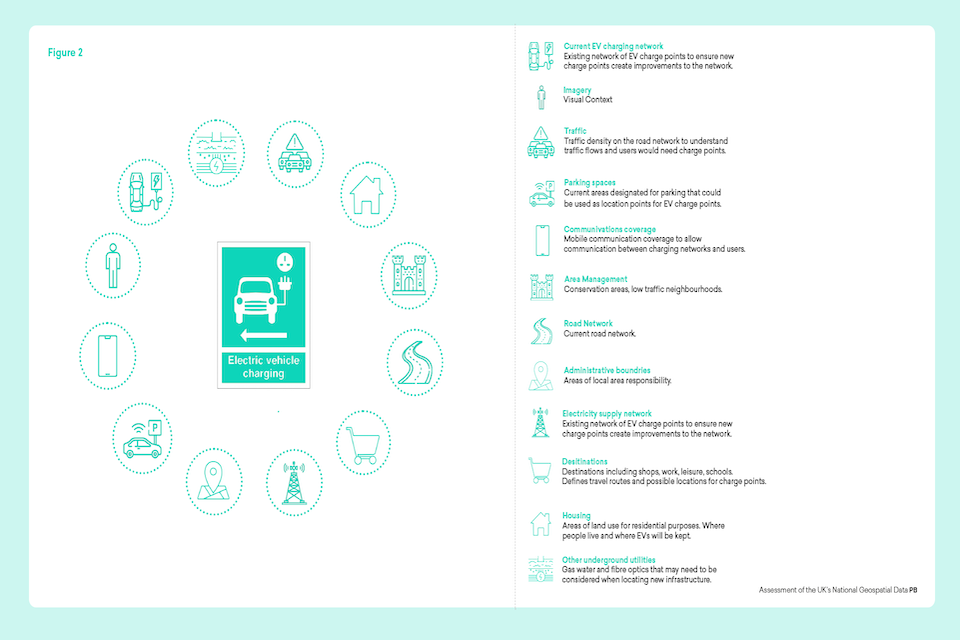
The range of data that users may require where to locate public electric vehicle charging points. This includes road networks and housing
Managing geospatial data proactively and holistically
In addition to challenges because of the range of different data sources, different approaches to data maintenance can impact how useful data is. Generally, data needs to be managed effectively for value to be derived and sustained or it risks degradation and ultimately becomes unreliable and unusable. The risks of ineffective data management are particularly pronounced in the public sector, where decisions based on data use for analysis, policy development and operational delivery can have significant consequences for lives and livelihoods.
One challenge arises because the value derived from geospatial data relates to the utility placed on its content and the services that support use of the content; both of which can vary over time. For example, the information content of geospatial data will change with use: a land boundary changes following a property transaction; the road network map adapts when a new road is created. In some cases, data can become more or less relevant following advancements of scientific understanding such as learning about the causes of climate change. Therefore, the currency of data is a key enabler to its use.
As changes to data are made in one area, there could be wider impacts: a change in land boundary may impact conservation designations; a new road may require new locations for air quality monitoring; a new housing development may change flood risk maps. Many such interactions exist, so if data is maintained in isolation these interactions can be inadvertently damaged or just not established in the first place and thus result in a loss of value.
The value derived from data is inherently linked to the services enabling its discovery, access and use. These equally require both repair and maintenance to both deliver adequate service levels and respond to technological evolutions. Technological change can offer enhanced opportunities for data use, but may require data to be migrated from legacy storage and exchange formats.
It is, therefore, critical that data producers keep step with one another and their user base. This requires a holistic view on the impact that their improvement and maintenance regimes have on the UK’s geospatial data overall. To achieve this, the UK requires a standard coordinated approach that enables data producers to factor this into their thinking and strategies when considering how to prioritise changes to their respective data sets.
Actions taken so far to improve UK geospatial data
Mission 2 of the UK Geospatial Strategy, to ‘Improve access to better location data’, sets out the UK’s commitment to streamlining, testing and scaling the development of new and existing location data. To deliver this mission, the Geospatial Commission works with six Partner Bodies (see Figure 3) and other geospatial data holders to maintain and improve geospatial data held in the public and private sectors, and across England, Northern Ireland, Scotland and Wales.
Through its Data Improvement Programme and other initiatives the Geospatial Commission has investigated the practical use of FAIR principles to improve geospatial data supply.
Figure 3: Geospatial Commission Partner Bodies
The British Geological Survey provides impartial and independent geoscience advice and data to the UK government, industry, academia and the public. It holds over 400 geoscience data sets, making it the authoritative source of geological and geo-environmental data for the UK.
The Coal Authority manages the effects of past coal mining. It holds and updates authoritative data on over 170,000 mine entries, surface and underground mine workings that sit underneath 25% of all properties in Great Britain. Its data is used for property conveyancing and the management of land and infrastructure.
UK Hydrographic Office provides geospatial information about the world’s oceans. Its products include the charts and custom location data sets used by 90% of world shipping vessels.
HM Land Registry records and guarantees the ownership of over 25 million properties across England and Wales, acting as the official record of all mortgages against property. The data held in the Register logs residential, commercial and agricultural properties making up some 87% of land in England and Wales, a number which continues to grow.
Ordnance Survey creates, maintains and distributes detailed location data for Great Britain, maintaining 500 million geospatial features in the MasterMap database with 20,000 changes each day.
The Valuation Office Agency holds information to fulfil its statutory functions and provide the valuations and property advice needed to support taxation and benefits. This information underpins the collection of approximately £55 billion of revenue in non-domestic rates and council tax in England and Wales, which helps to fund essential public services.
Data Improvement Programme
The Geospatial Commission initiated a Data Improvement Programme (DIP) with the six Partner Bodies. Starting in 2019, the DIP has undertaken an analysis and delivered initial improvements to the UK’s foundational geospatial data. Outputs from the DIP can be found on the Geospatial Commission’s website.
The DIP identified that the UK requires a sustained, collaborative and coordinated approach to data improvement to deliver targeted geospatial interventions with clear outcomes and benefits. The principles of Findable, Accessible, Interoperable, and Reusable (FAIR) were found to be the most useful way to communicate, categorise and contextualise data improvement activity across different data sets, organisations and sectors. See Figure 4.
Figure 4 - FAIR - Findable, Accessible, Interoperable and Reusable
The FAIR principles support data improvement and are a foundation of the UK National Data Strategy. In our Annual Plan we set out the basis of a programme to specify in practice what FAIR means for geospatial data such that improvements could be made in a systematic and transparent manner.
-
Findable: Findability is simply the capability of something being found and in recent years this means data discovery through a web search engine. Data should be easily and repeatedly discovered by experts and non-experts. Having found data, it is easy to determine whether the data is appropriate for their intended use. To support this any data should always have good discovery metadata and be published somewhere that it can be easily searched.
-
Accessible: Accessibility refers to reducing the hurdles from data discovery to obtaining the data. To be accessible, the terms for using the data should be clear and simple with registration and authentication to data services minimised. Data should be designed with accessibility in mind, wherever possible turned into products that are tailored to common usage and delivery methods using open and widely used standards and formats
-
Interoperable: Interoperability is the ability of different geospatial systems to accurately and unambiguously exchange data. Data needs to be designed to support interoperability, which means some consideration must be given to potential systems that may want to consume the data that is published. To enable interoperability, geospatial data should be available in multiple standardised open formats. These formats should contain information to support transformation of the data between common datums, projections and systems. Data should also contain, where appropriate, persistent, globally unique identifiers (for example Unique Property Reference Number (UPRN)) at the record or feature level.
-
Reusable: Reusable is the ability for value to be derived from using the data. In practical terms this means supplying information that supports the Findable, Accessible and Interoperability aspects of the data. Usability information is typically documented as part of the data set metadata. Metadata should be written such that both a specialist and non-specialist user can understand whether the data is suitable for their purpose. This includes clear advice on the constraints there may be on its suitability for common applications outside of its primary intended use and what mitigations may be appropriate to apply.
To establish an understanding of current practice for FAIR data improvements we undertook an assessment of the practices of our Partner Bodies. Our Partner Bodies were selected as a large and important subset of UK public sector geospatial data holders, including those with responsibility for operational data supply. This approach is a starting point for our ambition for a more widely scoped assessment, which could be applied to other organisations that hold crucial geospatial data, including the devolved administrations.
In undertaking this assessment we were aware that while there is widespread agreement that ‘FAIR’ is a good aspiration, what this means precisely in practice is less well established. We sought as part of our assessment to determine what practices are being followed and whether these are developed in-house or by a wider community. For example, initiatives exist that look at implementing FAIR in an objective context such as the GoFAIR and FAIRsFAIR programmes.
Geospatial Commission programmes
The Geospatial Commission is also leading on a range of programmes where FAIR data challenges will be raised and addressed. In addition, the Commission is exploring what are the wider challenges to data improvement, such as lack of skills and capabilities, maintaining public confidence in use of geospatial data, and lack of clarity around relevant data regulations or approaches to establishing the case for investment in data assets.
National Land Data Programme (NLDP)
Optimising land use requires a joined-up approach to decisions about land use at national, regional and local level to resolve competing priorities. To ensure these decisions are based on evidence and stand up to public scrutiny, data about land is fundamentally important. It is also held across a wide range of organisations and as such data is often difficult to find and access. Where it can be accessed, it is often not interoperable with other systems, or cannot be reused due to a mixture of licensing arrangements or proprietary formats.
National Underground Asset Register (NUAR)
As announced in September 2021 the Geospatial Commission is leading the development of the National Underground Asset Register. This provides us with an opportunity to work with a wide range of stakeholders across the public and private sectors to develop and embed FAIR principles through the NUAR platform, which in turn will flow back to the organisational level through the provision of data transformation schemas which will increase interoperability and accessibility of the data those organisations are providing to the platform. Like NLDP, NUAR also provides us with a real world application areas within which we can test and refine the implementation of FAIR principles, testing the guidance produced to ensure that it meets a variety of data producer types and application areas.
Ethical considerations of geospatial data
Appropriate ethical considerations are a critical input and consideration for our collective approach to developing and implementing FAIR principles across the UK geospatial data ecosystem. As highlighted the Geospatial Commission is looking to develop guidance on ethical use of location data, which in turn will help data producers to assess their technology choices in order to maximise the opportunities offered by it, whilst also not inadvertently damaging public trust or breaching privacy concerns. Findings from a Public Dialogue on location data ethics were published in December 2021. The findings will inform the development of guidance due to be published in 2022.
Economic valuation of geospatial data
All FAIR improvements will require a cost and benefit consideration at some level. In some cases this will be trivial, in others more complex. Economic appraisal of value driven by data improvements is a challenging area, especially when improvements are cumulative and long term, and when specific user requirements are yet to evolve. The development of a Code of Practice for FAIR data improvements will benefit from parallel activity being undertaken by the Geospatial Commission on valuation approaches to geospatial data. This work is due to be published in 2022 and will inform the development and application of the FAIR principles.
2.Assessment of the adoption of FAIR principles
FAIR principles are widely adopted by our Partner Bodies to guide data improvements, but there is variability in their application leading to fragmented improvements to supply.
Applying and benchmarking FAIR in Partner Bodies
To develop the Mission 2 of the UK’s Geospatial Strategy, we have been working with our Partner Bodies over the past year to develop and test an assessment framework for FAIR data principles as applied to UK public sector geospatial data. Our aim being to add rigour and clarity to the UK’s approach to maintaining and upgrading its geospatial data assets.
We started with collectively benchmarking the current application of FAIR data principles, establishing a set of initial FAIR definitions. The definitions are based on published approaches (see Figure 4), the findings of the DIP and existing initiatives related to FAIR. Details of the assessment results are presented in subsequent sections of this chapter and a high level overview is shown in table 1 using a three level categorisation of current practice:
- Good - Wide consensus among the Partner Bodies and the Geospatial Commission of what this principle is based on and that current standards, technology and industry norms are being applied. Widespread and consistent practice for its implementation.
- Improving - General consensus amongst the Partner Bodies and the Geospatial Commission of what FAIR data improvements are required. Recognition that collectively current industry expectations are not being met, but there are plans for improvement. Fragmented and diverse practice for their implementation.
- Attention required - Limited consensus amongst the Partner Bodies and the Geospatial Commission of what FAIR data improvements are required. Currently not well understood and/or not being addressed to meet anticipated future demand given current technology, standards and emerging policy.
It should be noted this grading is for UK geospatial data overall and not for that of individual organisations. The purpose of this approach is to understand the current application of FAIR data principles for geospatial data held in the public sector in the aggregate so as to start to identify systemic challenges as well as common good practice. Often there are no clean boundaries between FAIR and an associated data improvement. For example, an improvement targeted at making data more ‘reusable’ will often improve ‘accessibility’ and ‘interoperability’ at the same time. As such our FAIR practice benchmarks should be considered as an indicator rather than absolute measure.
Table 1: Summary of FAIR practice by our Partner Bodies
| Findability | Good | We found that most Partner Bodies data products and services (digital and non-digital) are initially findable through a standard web search, directing the user to data services on a supplier’s website. Once on a supplier’s website, products and services provided through mapping portals are mostly user-friendly and easy to navigate, although user interfaces for portals are not standard across Partner Bodies with only some allowing deeper levels of search and filtering. |
| Accessibilty | Improving | Most Partner Body data sets are accessible through their products and services whilst others are still in development. Also, while most data is technically accessible, licensing terms and conditions may be overly complex to many users. Additionally, some licences are out of step with how we collectively use data today. |
| Interoperability | Attention Required | While many of the Partner Bodies have begun to use unique identifiers and provide data in multiple common data formats there is still an underlying assumption that each organisation’s data is unique and niche and therefore wider system interoperability is not a focus currently. This means that while interoperability is good when looking through the lens of an individual organisation, it is not when looking through the lens of a common UK geospatial data supply network. |
| Reusability | Improving | Many of the UK’s geospatial data sets are inherently usable for their intended purpose with support and guidance available. There is, however, not a full understanding of their ‘usefulness’ more widely in terms of the value to the economy. This is also demonstrated in the licensing and limits on use in some data products. |
Findable: Widespread good practice
Overall, we concluded that approaches to support the findability of geospatial data are Good. We found that most Partner Bodies data products and services are findable through a standard web search. Furthermore, products and services provided are user-friendly and generally easy to navigate.
Strengths and good practice
Ongoing improvements to existing data discovery mechanisms.
The structure of the UK’s geospatial data services continues to evolve, increasing findability. The Ordnance Survey (OS) is investing to improve the matching of 2 million links between highways data and the National Street Gazetteer. The UK Hydrographic Office (UKHO) and HM Land Registry (HMLR) have undertaken a full review and rationalisation of the data that they publish on gov.uk to simplify the user experience. The Coal Authority is developing a new system to make their coal mine abandonment plans and historical photographs more findable and accessible for the end user. The British Geological Survey (BGS) issues a digital object identifier (DOI) for data sets it holds as DOIs are increasingly used by earth scientists.
Standardised approaches to data discovery
Supported by the Geospatial Commission, the Partner Bodies have agreed on search engine optimisation and metadata guidance. BGS metadata catalogue has been refreshed and now contains c.1,400 metadata entries compliant to standards for Open Geospatial Consortium (OGC) catalogue services. The Coal Authority is improving its metadata capability and is publishing more metadata records. The OS is improving its metadata capability and catalogue, aligning to UK GEMINI. HMLR has enhanced keywords, themes and descriptors and detailed abstracts in their metadata. UKHO is upgrading bathymetry metadata to MEDIN 3.1 (UK GEMINI compatible[footnote 1]).
Improvement areas and constraints
Archive and historic data held as hard copy
Many public sector organisations, including our Partner Bodies, have extensive legacy data holdings. Much of this is held in paper form or on legacy ‘unconnected’ systems meaning that it is not findable externally by users through the usual searches and portals. Guidance has been agreed by Partner Bodies through the DIP on archive data capture. However, it is not always considered value for money to undertake this type of work as the costs of data digitalisation are high both in terms of financial and technical overhead. These are such that they can often outweigh the direct benefits to the data producer, which makes it challenging for them to create the necessary investment case particularly within the public sector.
Improving and rationalising legacy systems
Evolution of practices has led to organisations having a number of similar systems delivering similar services. BGS, for example, are rationalising the number of delivery systems they have and maintain through a detailed information and data register. The aim is to reduce user confusion and make data easier to find and maintain for both the user and publisher.
The Valuation Office Agency (VOA) currently uses geospatial data layers held within dedicated legacy geospatial data applications which are easily findable to internal VOA staff. These applications do not have the ability to export or provide access to the data outside of their own environment therefore external users are unable to access or use the data held within these legacy applications in other geospatially enabled systems elsewhere within the organisation.
Accessible: Consolidated approaches to improve accessibility
Our initial assessment of the accessibility of Partner Body data is Improving. Most partner body data is accessible through their products and services, but some of these are still in development. While most data is technically accessible, in practice the licensing terms and conditions of use are complex, for example, written in language that is not common use.
Strengths and good practice
Simplification of data licencing terms
Partner Bodies recognise the current complexities in licensing and access, and good progress has been made during the DIP on data sharing agreements and simplification of data licensing terms. The Partner Bodies through the DIP have introduced:
A common set of simplified introductions across contract licences to aid the public sector with understanding the terms and conditions of use and reuse.
A common data exploration licence to support research and development and development purposes.
Steps towards publishing more data to make it accessible
The Partner Bodies have adopted and are using the Data Sharing Risk Assessment to help assess the risks and next steps involved in releasing legacy data sets.
Increased standardisation of data services
Partner Bodies have shared best practice, resulting in the creation of dedicated portal design guidance to advise on how best to create accessible geospatial data. Open Geospatial Consortium (OGC) standards such as WMS (Web Map Server) and CSW (Catalogue Service of the Web) have been widely adopted. This means that many of the data services provided by organisations can be accessed through standard geospatial web and desktop software clients.
Most Partner Bodies use International Organization for Standardization (ISO) Geospatial Standards and OGC Standards, and are investigating the next generation of standards to make the data more accessible in the future. This will help underpin the next generation of user portal interfaces as well as make it easier for other systems to interface with the Partner Bodies geospatial data.See Figure 5
Figure 5: Register of core geospatial data standards
OS and BGS staff recently reviewed the current geospatial data standards to support FAIR data principles. This work is published by OS in partnership with Geospatial Commission in the report Geospatial Standards for Authoritative UK Data Providers: A UK Set of Standards and Priorities. The set of open standards identified are cross domain, focusing on metadata and data transfer formats. Examples include use of UK GEMINI metadata standard for geospatial data, use of GeoJSON and GeoPackage for vector data transfer and delivery, GeoTIFF for raster data and OGCAPI-Features for API access to data.
Under the auspices of the Geospatial Commission, the British Standards Institute IST/36 Geographic Information Committee is responsible for the ongoing review of this list of standards under the title of the “National Geospatial Data Standards Register”. This activity is in cooperation with the government Open Standards Board and Data Standards Authority and their recommendations on standards for cross government use.
Steps towards greater precision in data download to access ‘just what you need The Public Sector Geospatial Agreement, through the OS Data Hub, is introducing the ability for users to select and build their own data products which contain only the geospatial features that they require rather than having to take full data sets if they do not require them.
Improvement areas and constraints
Variations in approaches to authentication and payment systems
Most organisations have transactional services but these are not standard between organisations. Consequently, a user is often faced with multiple types of payment/subscription requests when accessing a variety of data from different organisations, which adds time and complexity to the process for accessing the data.
Sharing restrictions, derived data and third party intellectual property rights
Some Partner Bodies manage a number of restricted data sets that cannot be shared easily due to third party intellectual property (IP), ownership, privacy and legal restrictions. An example of this is legacy borehole data held by BGS. Their current borehole collection contains over 1 million records covering the whole of Great Britain with 50,000 new records added each year. While some records date back to the 1600s the majority date from the 1900s onwards. Much of the data was collated from historical infrastructure schemes where the third party intellectual property rights to enable onward reuse of the data had not been considered at the time of collection. BGS has invested in opening up this archive and has made progress in improving data sharing agreements for the National Geoscience Data Centre (NGDC) to ensure recent data deposited is widely accessible.
However, due to these complex legacy third party issues not all of the data is available for reuse currently. A further example is property attribute data held by the VOA. To fulfil its function of valuing properties in England and Wales for taxation purposes, the VOA collects property attributes (such as property function, type, age, number of rooms) for every taxable unit in England and Wales. The Commissioners for Revenue and Customs Act 2005 (CRCA) prevents the VOA from disclosing the information it collects on property attributes except for the purposes of its functions, where there is a legislative gateway or with customer consent. In September 2021, the Geospatial Commission’s intention to introduce primary legislation which would improve access to property attribute data held by the VOA was publicly announced.
Interoperable: Data is still largely supplied for distinct systems
Overall, we assessed the current approach towards interoperability applied to Partner Body data as Attention Required. To support interoperability many of our Partner Bodies have begun to use unique feature identifiers in data sets and provide data in multiple common data formats. These are, however, predominantly aligned to the organisation’s data. This means that while interoperability is good when looking through the lens of an individual organisation, it is not when looking through the lens of a holistic UK geospatial data supply network and potential future demand.
Widening data exchange to support interoperability between organisations is a persistent challenge, growing as the breadth and depth of data driven decision making increases. The move towards open standards is supporting wider syntactic interoperability, but the richness and diversity of geospatial data means semantic interoperability can still be complex and nuanced. Fundamentally geospatial data is one community’s view of the world and this view may not be shared or understood by another community with whom data is shared.
Strengths and good practice
Multiple formats for data supply
Most organisations’ data is accessible in multiple formats. However, the selection of formats, for example GML, CSV, Shapefile, TIFF or GeoPackage, offered does differ between organisations. A recent survey conducted by the OS as part of the PSGA standards work showed that the most common geospatial data format is Shapefile followed by GeoPackage. Most Partner Bodies data services provide at least one (and often many) open data formats. Open file formats enable end users to ingest data more easily and transform data from common geospatial formats into other formats such as .DGN format used within computer-aided design (CAD) packages.
Common approaches to referencing
Across Partner Bodies there is increasing use of unique identifiers, such as UPRN and Unique Street Reference Number (USRN), to provide the means of linking different data sets together more accurately and rapidly by both humans and machines. For example ownership data held by HMLR incorporates the UPRN, which can be linked via AddressBase to the underlying building in MasterMap. Increasing the inclusion of common identifiers within data sets is a key step to enabling users to bring data together to gain greater geospatial insight and intelligence. The Geospatial Commission worked with GeoPlace, the Local Government Association, Improvement Service and OS on the opening up of UPRN and USRN register data. This enabled UPRNs and USRNs to be released under an Open Government Licence as part of the Public Sector Geospatial Agreement agreed by the Geospatial Commission in 2020. UPRN and USRN are recommended by the Open Standards Board for use by all government data relating to addresses or streets.
Furthermore, the Geospatial Commission as part of the DIP work recently assessed the concept of Correlation Relationships. See Figure 6 below.
Figure 6 - When is a lamp post not a lamp post?
The true power of geospatial data can be unlocked when reliable links are made between data sets. Therefore, it is standard practice for geospatial analysts to relate features from multiple data sets via common identifiers, for example geographic coordinates and addresses.
However, the situation becomes complicated when a relationship is required between features that although share common identifiers, for example geometries and attributes, they represent different types of features. Think of a point on a map that represents a street lamp post, a telecommunications mast and an electric vehicle charge point in different data. In such cases you may wish to correlate the three data sources into one, creating a correlation relationship that accurately describes the features represented by a single point.
The issue is how do we assure that the relationship created is correct and accurately represents ground truth, particularly important when considering different boundaries of a property in different systems for different purposes.
Improvement areas and constraints
Cost benefit for cross domain system interoperability
The specification of what good system interoperability looks like between Partner Bodies and their wider market is not always obvious. As a result, Partner Bodies are not always able to plan for interoperability and can struggle to appraise the benefit versus cost of designing data interoperability outside of their core user base. Whilst this is understandable from an organisational perspective, it potentially misses opportunities for data users in other sectors who would like to use the data but struggle. Outside of government, the partnership between ESRI and Autodesk is seeking to solve the interoperability issues between the CAD and GIS domains as both collaborate when designing civil infrastructure in a building information modelling (BIM) environment.
Domain specific approaches to system interoperability
Each of our Partner Bodies provide specific services aligned to their respective public task. For example, the Coal Authority manages coal mine asset data and also provides coal risk assessments and consultations to developers and homeowners. The drive towards net zero has seen interest in repurposing abandoned flooded coal mines for mine source heating. This has seen an increase in interest in the use of mine plans and data held by the Coal Authority from energy consultants, companies, researchers and the Coal Authority itself to support feasibility studies, drilling and testing for mine water heat schemes. This is an application that could not have been foreseen when the information was originally captured.
The difficulty lies in trying to identify and assign value to any future potential of our geospatial data. In some cases data may have limited use beyond its primary purpose and original domain. Consequently, re-engineering data to maximise its reuse may not be worth the time and cost. Our Partner Bodies are therefore mindful about where to invest in interoperability to generate the biggest impact for their community.
Reusable: Data is supplied with usability in mind
Overall, we have rated the assessed geospatial data reusability from across Partner Bodies as Improving, mainly due to the mixed approach to reuse. Some of the UK’s data is created explicitly with reuse in mind. However, data reuse is also constrained by licensing limitations and in some cases organisational remit. In all cases the full value of data reuse to the economy is not understood completely.
Strengths and good practice
Licencing terms designed with reuse in mind
There are good examples of organisations publishing derived data guidance for users. The OS has published a derived data policy for licensed data, enabling users to identify what they can do with their derived outputs.
The Data Exploration Licence (DEL) delivered through the DIP enables greater use and access of data. Partner Bodies in many cases have extended the DEL to cover multiple data sets at once. Previously they would have issued a separate licence for each instance of data supply regardless of whether the data user already had an agreement in place for another data set. Now organisations are able to treat the DEL as an umbrella agreement which only needs signing once. Some Partner Bodies have also extended the DEL to a rolling 12 month term, instead of the previous fixed three month.
Metadata supplied with use in mind
Partner Body organisations following the DIP are producing clearer, more contextual metadata that is suitable for non-specialists and data users outside of the original domain. This is enabling users to understand the provenance of the data and whether to reuse the data for a wider range of purposes.
Most Partner Bodies products are accompanied by a comprehensive set of specifications, use cases, examples and technical guides that explain what the data set is designed for, how to use it, what other people have done with the data and any limitations of the data set.
Following the DIP work there is a concerted attempt across the Partner Bodies to ensure they are using Plain English so that their data is more easily understood. Where specialist language is used, glossaries of specialist terms are provided.
Improvement and constraints
Pricing, terms and conditions
There are issues due to variations in pricing, terms and conditions preventing access and reuse of data assets. This is a particular consideration with well established products, such as traditional map based data, which may be digital scans of hard copy charts and where the original business model for them was based on hard copy data supply.
In such cases there is a balance between data funding models, licensing and intellectual property to consider against the resource needed to support wider accessibility and reuse of data and what represents the best value for the taxpayer. Figure 7 gives a typical example.
Figure 7 - BGS National Geotechnical Properties Database (NGPDB)
The BGS NGPDB contains in situ and laboratory test data from approximately 195,000 third party site investigation boreholes from across the whole of Great Britain.
Within BGS, the NGPDB is used for research that facilitates the planning, design and construction of buildings and infrastructure, and the mitigation of risk to these structures. The data which, in addition to geotechnical data, also includes geological, hydrogeological, geochemistry and physical property data, has the potential to be used more widely outside of BGS, particularly for research on groundwater, soils, large scale geohazards, renewable energy, energy storage and radioactive waste disposal. However, there are barriers to reuse which include:
- Complex third party intellectual property arrangements and uncertainty related to the original data owner
- Lack of confidence around the source and therefore quality of the data
- Difficulty in extracting the data from a legacy database.
In summary, while many organisations would hope to maximise reuse of their data assets, the internal business case for FAIR improvements are non-trivial as there is a range of topics that need to be unpacked to appraise the cost benefit.
Existing business models and remit
Some geospatial data is only available under a commercial licence that comes with onward restrictions to protect intellectual property. This commercial licensing business model and associated licence condition exists to enable support and maintenance of data in the long term.
Another example is the case of VOA, as a statutory body its functions are set out in legislation including how and when the data it collects can be used or shared.
Quality: A key consideration for the implementation of FAIR
Quality was identified by the Data Improvement Programme as a crucial concept alongside FAIR in order to realise value from data. The quality of a data set needs to be defined by the user of the data as to how it serves their purpose. Without an adequate understanding of quality requirements, FAIR interventions run the risk of being over engineered and/or not meeting user demand. See Figure 8 as an example.
Figure 8 - Meeting user requirements
Data quality is often couched in terms of accuracy, precision, resolution, completeness. For geospatial data users the underlying content and presentation of data is also key to understand if the data is ‘fit for purpose’.
For example, the UKHO produce navigation charts for the navigation community according to the International Hydrographic Organization (IHO) S-57 standard. These charts are published through a global catalogue and distributed through a network of suppliers. The charts can be loaded directly into the navigation systems used on merchant and military vessels. From the perspective of the navigation community and the remit of the UKHO these key navigation products adopt global good practice for both Quality and FAIR and the two are tuned together effectively.
Outside of navigation, for example the offshore wind community, perspectives may be different as users may have no knowledge of the IHO distribution network and may not have software that can interpret the S-57 data model. They may also not be aware that depth information in the chart is optimised for safety of navigation and not necessarily a wholly precise reflection of reality or that only shipwrecks that are considered a navigational hazard are included.
The FAIRness and quality for a given data set and the necessary steps in order to improve it should, therefore, take account of different views of quality - even when applied to the same data. This is because the same data might be required for a range of different purposes. While many of these views will intersect and overlap, the challenge is how best to accommodate different viewpoints and perspectives on FAIR to ensure it is fit for purpose.
Figure 9 - Fine tuning FAIR improvements
Our UK geospatial assets must comprise products and services that are both ‘Quality and FAIR’. In the same way that we balance the sound levels on a music system to our own preference we also need to balance our data.
Different parts of our geospatial ecosystem will require different levels of FAIR. This will change over time as skills and technology improve, increasing demand on our location data, products and services. FAIR improvements therefore need to be thought about from the perspective of operation and application of the end user (Quality).
In the same way that turning up the volume on a sound system with the wrong balance results in distortion, simply turning up the Quality on unFAIR data will not unlock the power of location. For example, providing increasingly precise survey data with no date or audit trail still does not allow the end user to reuse the data. Some of the elements of FAIR will crossover with Quality but others such as the thematic content, precision and completeness do not wholly fit within FAIR.
Quality: Data quality is not aligned strategically to FAIR improvements
Overall, we assessed the current approach towards quality as Improving. This is because although quality is an area that all of the Partner Bodies take seriously at an individual level, it is not always systematically linked to FAIR improvements at the UK strategic level.
All Partner Bodies have good data governance structures in place and most publish a data strategy or roadmap. Encouragingly we found that all organisations conduct a data sharing risk assessment of their data, some using the data sharing assessment tool developed by the DIP programme. Most noted that significant data risks are reported in their corporate risk register.
There are also a range of data quality standards and frameworks associated with geospatial data that the various Partner Bodies comply with such as those published as part of the national data quality framework that provides guidance on several dimensions that typically can be used as quality measures. At the same time there are many specific geospatial data standards, including ones for quality management (see Figure 10 below).
Most of the Partner Bodies also conduct regular stakeholder engagement on their data products and services, but there is large variability between the frequency, depth and breadth of this engagement. There is no coordination or identified ‘central space’ for a community of practice to share lessons, ideas and innovation, instead Partner Bodies rely on project groups and ad hoc communities, as well as industry groups.
Figure 10 - ISO standards for geospatial data quality
ISO 19157:2013 establishes the principles for describing the quality of geographic data. It:
- defines components for describing data quality
- specifies components and content structure of a register for data quality measures
- describes general procedures for evaluating the quality of geographic data
- establishes principles for reporting data quality
ISO 19157:2013 also defines a set of data quality measures for use in evaluating and reporting data quality. It is applicable to data producers providing quality information to describe and assess how well a data set conforms to its product specification, and to data users attempting to determine whether or not specific geographic data is of sufficient quality for their particular application. ISO 19157:2013 does not attempt to define minimum acceptable levels of quality for geographic data.
3.Conclusions and next steps
There are systemic challenges that need to be addressed to establish FAIR at the national scale. We plan to build on current good practice to develop an agreed Code of Practice for FAIR data improvement.
Systemic issues
Our assessment has shown that application of FAIR principles has enabled progress to be made in improving the use and exchange of geospatial data. This is a good starting point to address areas of obvious challenge, but there remain wider and systemic challenges to improving UK geospatial data, particularly as its volume and demand increases.
It is worth noting that the challenges outlined below are not unique to either our Partner Bodies or, in some cases, geospatial data.
Organisational priorities and culture
The UK’s public sector geospatial data is supplied by a range of organisations - agencies, departments, devolved administrations and local authorities - all with distinct governance, policy remits and business models. This results in both a complex landscape for users to navigate, and an organisation centred approach to geospatial data improvement in accordance with individual organisational priorities. To realise the geospatial opportunity at a national scale, the application of FAIR improvements need to evolve and go beyond the organisational level.
Public sector organisations are established and operate to serve specific purposes. Over time, and recently very rapidly, the relevance of data to support a range of new economic, social and environmental outcomes has increased. However, sometimes organisational objectives may not have kept pace with these changes. For example, each of the Partner Bodies operates under necessarily different business models and with different purposes that dictate the prioritisation of resources to the delivery of their core objectives.
Any changes to priorities require a strategic assessment of the changing landscape and the benefits and challenges to the organisation. Even where the value of data improvement may be evident, for example to help an organisation deliver its core services more efficiently, more live and mission critical business objectives could overtake an organisation’s strategic priorities and soften what appears an obvious case for change. This is particularly the case with public sector organisations leading the delivery of critical services.
Delivering FAIR improvements across the whole of the UK geospatial system goes beyond the remit of a single organisation. Clarity needs to be established over where responsibilities sit - and a culture of collaboration across organisational boundaries is needed.
Capability and resources
Even if FAIR improvements are prioritised equally, not all organisations have the same capability or resources to identify and implement improvements. For example, there is a general consensus that the divide between new digital data and legacy data, which is primarily held in hardcopy, is widening.
Many organisations, including our Partner Bodies, report that they plan to digitise legacy data but face resource, skills or funding barriers to bring them up to the required market standard, or to use data in an upgraded form. Our assessment indicated there were missed opportunities to take full advantage of advancing technologies - such as AI and automation - to make data improvements.
Currently there are limited cross-organisational secondments and resource sharing to fill the skills gap. Where resource sharing does occur it is largely as a result of interventions such as the Public Sector Geospatial Agreement or other externally funded work. Such approaches allow the organisation that is exporting the expertise to backfill their loaned resource and thus not impact on their core delivery. Without this ability, however, it is difficult for those with the resources to justify the reduction in their capability for the period of a loan where it negatively impacts on their ability to deliver their core objectives.
Lack of supply chain influence
To create data sets with national coverage, our Partner Bodies collect data from both surveys and measurement campaigns they commission themselves and also through independent third party activities. Where data collection is directly commissioned there is formal control over the data supplied.
With third party actors, often where the data is donated, the quality of the supply can vary meaning extra effort to re-engineer the data. The Partner Bodies often rely on goodwill and have limited options to influence improvements to these third party supplies - or even to ensure it happens in all cases.
Community initiatives such as Marine Environmental Data and Information Network (MEDIN) have been set up to build critical mass to data sharing and agree good practice, but these too rely largely on voluntary commitments.
Aligning with wider frameworks
Industry standards
To work effectively, FAIR improvements need to be embedded in central processes and align with how organisations operate; taking full account of the standards they have agreed to follow and the performance they are looking to deliver. Most organisations have processes in place for business improvement, quality and increasingly this includes procedures specific to data management. Many of these are internationally agreed and documented in management systems standards such as the ISO 8000 and ISO 9000 series. With these come existing procedures for audit and reporting and so approaches for FAIR improvements need to be aligned with these approaches and not be an additional layer of compliance.
National and international data policy frameworks
There are a range of both national and international initiatives that both support and benefit from data FAIRness (see Figure 11).The Partner Bodies are world leading in their fields of expertise and therefore have been involved in the development of both international and national data initiatives at various different levels. It is therefore unsurprising that through the initial assessment the Partner Bodies highlighted that they look to take account of these initiatives as part of their operations and interact with them.
However, to date there has been limited cross organisational engagement on how these policies are implemented and aligned across organisations. Particularly in the international space it is important that the UK speaks with one voice when shaping initiatives, as well as having a common approach to meeting our commitments in a FAIR way. This can include data management and policy frameworks, as well as tangible infrastructure that can support data discovery and sharing.
Figure 11: FAIR improvements underpinning the wider data economy
National Data Strategy The National Data Strategy is a comprehensive, high level framework for leveraging the value of data across all sectors of the UK economy and society. Q-FAIR is aligned to commitments made in it, specifically in relation to FAIR improvements for geospatial data. A FAIR approach to data improvements is integral to the data foundation pillar and data availability pillar of the National Data Strategy.
Inspire The Inspire Regulation is UK legislation transposed from the European Union for geospatial data improvement. Inspire is a data standards framework designed to make sharing and reuse of data and data services easier. It requires public authorities to use common standards for geospatial data and data services across 34 data themes. FAIR improvements could be aligned to compliance with Inspire.
Integrated Geospatial Information Framework (IGIF) IGIF developed by the United Nations with the support of the World Bank, provides a basis for developing, integrating, strengthening and maximising geospatial information management and related resources in a country. As set out in the UK’s Geospatial Strategy, the UK has chosen to adopt the IGIF by implementing a national location data framework that is consistent with the IGIF. The principles of FAIR form a critical part of our approach to data, standards and governance of the nine key pathways identified in IGIF, informed by UK government priorities and industry needs.
Next steps
The conclusions arising from our assessment require a system-wide response. Technology is not the only answer; leadership, governance, policies, organisations, legal frameworks and skills matter too. The Geospatial Commission’s programme of work, set out in our Annual Plan, raises and addresses many of these areas.
Our approach to the application of FAIR principles will be to establish consensus on methods and processes, and to develop a new Code of Practice.
Common agreed approaches
Current guidance on FAIR implementation is not specific to the UK or to geospatial data. From an operational perspective there needs to be agreed explicit FAIR norms that can be implemented routinely at the organisational level to geospatial data within the UK, taking account of existing legislation such as Inspire. Guidance is also required about how to appraise options for how FAIR improvements are best implemented and where responsibility sits for making those improvements where those enhancements transcend responsibilities of a single organisation.
For a consistent and systematic approach to FAIR for UK geospatial data, we believe that consensus is required in two areas:
- Establish and agree the targets or norms we want to establish for the data from a FAIR perspective. This will need to include identification of the relevant areas as well the minimum requirements in those areas and what variations are appropropriate to embrace. The areas currently identified include:
a. Methods for data publication and cataloguing, including metadata standards
b. Methods for specifying data products, including data content and formats
c. Methods for transforming legacy data
d. Methods for prioritising improvement activities
e. Methods for stakeholder engagement
f.Methods for reporting improvements
g.Methods for selecting applicable operational standards
2. Develop and implement the process by which we assess and appraise the data against the agreed targets and norms and determine interventions that could realise improvements. The key questions that will need to be addressed with this are:
a.How do we assess the geospatial data we need?
b.How do we segment and classify geospatial data?
c.How do we appraise cost effective FAIR improvements?
d.What does a benchmark report look like?
The above can be agreed largely from a consolidation of the current approaches to FAIR improvements that have been established and implemented individually by the Partner Bodies and the wider geospatial ecosystem.
A new Code of Practice
Building on work to date, and in partnership with the wider UK geospatial ecosystem, the Geospatial Commission will lead the development of new Code of Practice for FAIR improvements to UK geospatial data.
Codes of practice recommend sound good practice as currently undertaken by competent and conscientious practitioners. They are drafted to incorporate a degree of flexibility in application, while offering reliable benchmarks.
Our ambition is that a UK public sector geospatial Code of Practice becomes a standard operational activity that can be deployed routinely to benchmark the quality and FAIRness of UK geospatial data, services and products providing insight and generating options for improvements to bring about change that meets future demand.
The topics covered within the Code of Practice are fundamental to how geospatial data is supplied in the UK and will require careful consultation and assessment for how they should be taken forward. This will be achieved through a proven standards development process. We will pilot our Code of Practice among public sector organisations, starting with the Partner Bodies and widening through successive pilots, improving and learning as we progress.
The Code of Practice will embrace the diversity of the geospatial supply chain and market to ensure that, for UK geospatial data, FAIR is transparently applied with improvements that respond to evidence of demand. Delivery will be achieved through organisational adoption and practice, targeted sector-wide projects and consideration of the wider context for data supply. We will publish an update on progress next year.
Glossary
| Term | Description |
|---|---|
| Data processing levels | Data processing starts with data in its raw form and converts it into more readable formats, for example maps, giving it the form and context necessary to be interpreted by computers and utilised by users. Many data sets offer a range of data levels, allowing users to choose the processing level that best fits their purposes |
| FAIR | In 2016, the ‘FAIR Guiding Principles for scientific data management and stewardship’ were published in Scientific Data. The authors intended to provide guidelines to improve the Findability, Accessibility, Interoperability, and Reuse of digital assets. The principles emphasise machine actionability (that is the capacity of computational systems to find, access, interoperate, and reuse data with none or minimal human intervention) because humans increasingly rely on computational support to deal with data as a result of the increase in volume, complexity, and creation speed of data. (source Go FAIR) |
| Geospatial data | Geospatial data is the record of what we do and where we do it. It tells us where people and objects are in relation to a particular geographic location, whether in the air, on the ground, at sea or under our feet. Geospatial data is gleaned from many diverse sources in varying formats and can include information such as census data, satellite imagery, weather data, cell phone data, drawn images and social media data. In this report the term “geospatial data” refers to all levels of data processing. |
| Geospatial data product | Representation of data designed in a structured way to meet explicit user requirements. A data product specification would define the data set content, spatial and temporal extents, purpose, sources, production processes and maintenance. |
| Geospatial Network | A connected network (both organisational and systems) of geospatial data that together allow better information and knowledge exchange across a sector, multiple sectors nationally or internationally. |
| Geospatial Ecosystem | Geospatial firms offer a range of diverse products and services across multiple industries; it is not appropriate to view geospatial activity as taking place within a single economic market (Figure 2). Activity is better visualised as a geospatial ecosystem containing individual submarkets, based on specific groups of products and services. (Frontier Economics) |
| Interoperability | The ability of systems (connected devices and software) to unambiguously exchange and make use of data. Commonly this refers to syntactic interoperability (communications protocols and data encodings) and semantic interoperability (the meaning associated with the data). |
| ISO | The International Organization for Standardization. |
| Partner Bodies | Our Partner Bodies as defined in the Geospatial Commission’s Charter and Framework: Ordnance Survey, HM Land Registry, British Geological Survey, Valuation Office Agency, Coal Authority and UK Hydrographic Office Figure 3 |
| Public sector data | Data that is held by a public sector organisation. This may be data collected routinely as part of providing public services or as required to deliver a specific project, task or request. |
| Standard | Standards all have the same basic purpose of setting out agreed principles or criteria so that their users can make reliable assumptions about a particular product, service or practice (Source BSI). |
Other common geospatial glossary terms can be found in our published Geospatial Glossary.
-
UK GEMINI specifies how to publish geographic metadata in a way that conforms to UK government guidelines and the relevant ISO standards. UK GEMINI (Geo-spatial Metadata Interoperability Initiative) is a set of metadata elements for describing geospatial data resources. It is provided free to users for the benefit of the UK geospatial community, under a Creative Commons licence. ↩