Geospatial Commission Annual Plan 2021/2022
Published 2 June 2021

© Crown copyright 2021
This publication is licensed under the terms of the Open Government Licence v3.0 except where otherwise stated. To view this licence, visit nationalarchives.gov.uk/doc/open-government-licence/version/3 or write to the Information Policy Team, The National Archives, Kew, London TW9 4DU, or email: psi@nationalarchives.gov.uk.
Where we have identified any third party copyright information you will need to obtain permission from the copyright holders concerned.
This publication is available at https://www.gov.uk/government/publications/geospatial-commission-annual-plan-20212022/geospatial-commission-annual-plan-20212022
Ministerial Welcome
We need look no further than the events of the past year to understand how important accurate and detailed data continues to be in tracking and managing the coronavirus pandemic. Geospatial data - data about location - has been a crucial part of the collective and global endeavour to mitigate the impacts of this disease.
As we begin to focus on economic recovery, geospatial data will remain a lynchpin, holding together other data to provide evidence and insights about how best to level up the UK. It will show us where to target investment into industries and innovations across the UK, how to improve the opportunities for our towns and high streets, where we can grow our regional skills and capabilities, how we can best protect and develop our rural economy, and how we transition to a greener society.
As a leading geospatial nation, the UK is well-placed to capitalise on the opportunities that high quality geospatial data can bring, not only building back better, fairer and greener for the UK, but also demonstrating the UK’s prowess as a global science and technology superpower in the field of advanced geospatial data and technologies.
In June 2020, this government published an ambitious five year strategy to unlock the power of location data. Much has been accomplished so far setting the ground-work for impactful change, with a significant upgrade of the UK’s foundational geospatial data taking shape and steps taken towards pinpointing sector-specific opportunities and addressing current barriers to geospatial data access and use.
The Geospatial Commission will continue to work towards realising the vision of a location-powered UK, staying alert to global and market changes and gathering evidence of the latest innovations at home and abroad, improving the prospects for all. Its developing priorities for this year include:
- Building the National Underground Asset Register (NUAR), commencing procurement for a national supplier to develop a new data asset for the UK to drive efficiencies in infrastructure delivery across the UK and help improve worker safety.
- Investing up to £4 million in phase 2 of the Transport Location Data Competition, to bring to market real-world applications of location data that help to make the most of our transport networks by boosting capacity, reducing environmental impacts and decreasing travel times.
- Developing the public dialogue on location data ethics, to support public confidence in the use of geospatial data and contribute to Pillar 4 of the National Data Strategy.
As with all opportunities there are challenges, and this includes unlocking the value of location data. This government is committed to considering and acting to mitigate ethical, security and privacy risks that may arise from greater use of geospatial data.
I am grateful to the Geospatial Commission for leading the way on this important agenda, working collaboratively with others across all parts of the UK to build on the wealth of existing expertise and to collectively progress our shared geospatial interests.

image of Lord True CBE
Lord True CBE, Minister of State
Board of Commissioners Foreword
In a rapidly advancing digital environment, location data is a strategic asset that is bringing immense value to our economy, society and environment. As the geospatial ecosystem continues to grow and evolve, the benefits of location data are reaching all sectors, industries and regions.
Last year the Geospatial Commission published the UK’s Geospatial Strategy with a transformative vision that by 2025 the UK will have a coherent national location data framework, guided by four missions focussed on promoting and safeguarding geospatial data, easing its use, enhancing capabilities and enabling geospatial innovation.
The UK has chosen to adopt the UN Integrated Geospatial Framework (IGIF). It describes all the elements - data assets, standards and technologies, policies and guidance, people and organisations – that are required to unlock the power of location. The missions and actions contained within the UK’s strategy are the key areas where we have prioritised the UK’s focus. We will continue to work across the UK to develop the UK’s framework, adopting the elements of the IGIF where relevant, working with a range of partners and organisations, including the Geospatial Commission’s six geospatial Partner Bodies. [footnote 1]
Whilst there are emerging challenges, and navigating the geospatial ecosystem continues to be complex, it is highly rewarding. This year, we have seen the power of data manifesting in new contexts, bringing applications that have the potential to improve outcomes across a range of services, including because of actions that we have previously taken. For example, we have seen the power of location data in the pandemic response, including new ways it is being used by local authorities. Unique property reference numbers (UPRNs), which we released in 2020 on open terms, have been used to link datasets that were previously siloed, to identify residents most in need of support.[footnote 2]
We are one year along on our 5 year journey, and we have already taken important steps to achieving the UK’s vision. We have:
- Delivered phase 1 of a new Transport Location Data Competition, investing £2 million in innovative geospatial solutions to contemporary transport challenges.
- Published the UK’s first Geospatial Data Market Study alongside our Enhancing the UK’s Geospatial Ecosystem report, detailing recommended activities to enable the full potential benefit of location data to the UK economy.
- Launched a Public Dialogue on Location Data Ethics to better understand views from members of the public about the use of location data.
- Opened up direct, API access to location data for the public sector as part of the Public Sector Geospatial Agreement (PSGA) to transform how location data is used to support government policy and underpin public services.
- Invested further in location data quality and access improvements across the public sector, through a productive data assessment and improvement programme of joint working with our six Partner Bodies.
- Convened a Skills Forum with a diverse and cross-sector membership to build a collaborative approach to enhancing the UK’s geospatial capabilities, skills and awareness.
- Welcomed the Government Geography Profession into the Cabinet Office to provide greater support and enable future initiatives for skills development in the public sector.
Understanding the strategic importance of location data is a global initiative. We will continue to showcase the best of UK capabilities with international partners whilst engaging and learning from international innovations and advancements.
We need the continued collective effort of everyone involved in order to achieve the UK Geospatial Strategy in full. We would like to thank our many partners who have contributed to the progress we have made over the past year. The case studies included in this Annual Plan reflect only some of the ways in which other organisations, individuals and institutions are innovating to unlock the value of location data. The team at the Geospatial Commission will continue to work with a wide range of stakeholders as we embark on new projects for the year 2021/22.
The Geospatial Commission’s Board of Commissioners
Sir Bernard Silverman, Chair
Nigel Clifford, Deputy Chair
Thalia Baldwin, Director
Dr Steve Unger, Commissioner
Edwina Dunn OBE, Commissioner
Dame Kate Barker, Commissioner
Kru Desai, Commissioner
Executive Summary
Geospatial Strategy
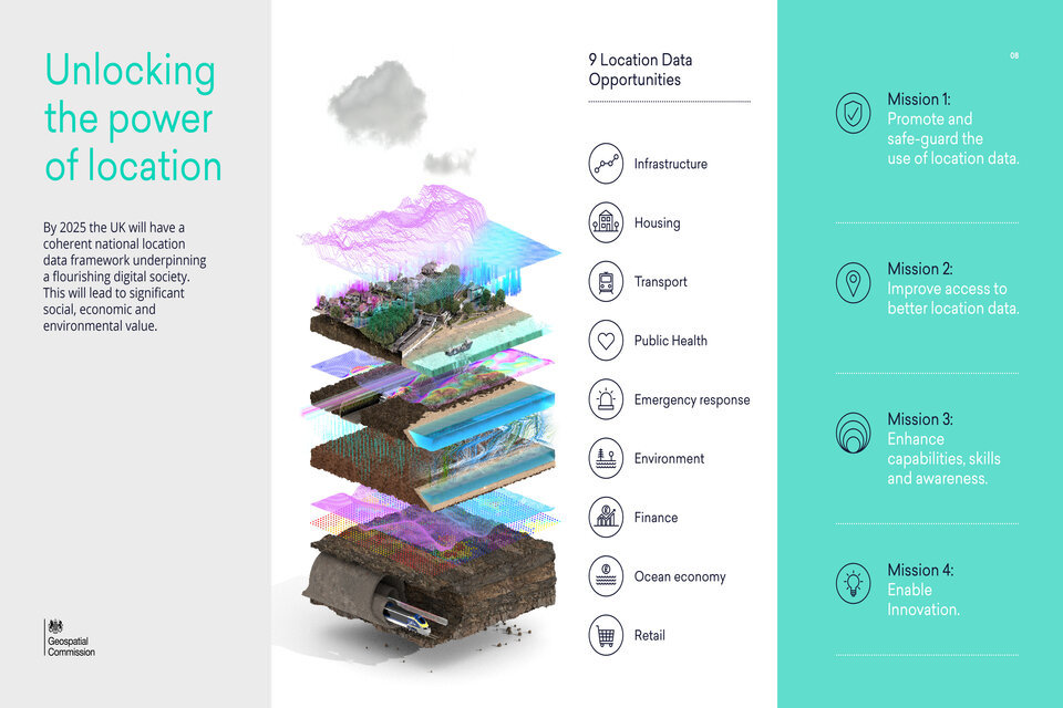
The UK Geospatial Strategy develops a vision for a coherent national location data framework by 2025. Future technologies will be underpinned by data about events occurring at a time and place. Location data will be the unifying connection between things, systems, people and the environment. Linking location data with other data will drive insights that will inform how to level up the UK, providing geographic context that will highlight the social, economic and environmental drivers of inequality across the UK.
The Geospatial Commission has been charged with delivering a transformative vision to unlock the power of location. Our work to date has identified nine location data opportunities[footnote 3], and has been developed in partnership with the key UK public sector geospatial organisations, the ‘Partner Bodies’[footnote 4], and other parts of the public and private sectors. Together we have identified challenges that have resulted in a complex and fractured geospatial policy landscape. The UK Geospatial Strategy outlines four missions to tackle these challenges and maximise the opportunities:
-
Mission 1: Promote and safeguard the use of location data. We need to provide an evidenced view of the market value of location data, set clear guidelines on data access, privacy, ethics and security, and promote better use of location data.
-
Mission 2: Improve access to better location data. We will streamline, test and scale the development of new and existing location data, ensuring it is findable, accessible, interoperable, reusable and of high quality.
-
Mission 3: Enhance capabilities, skills and awareness. To achieve our vision, we must develop more people with the right skills and tools to work with location data across organisations and sectors to meet the UK’s future needs and support global development.
-
Mission 4: Enable innovation. We will maximise the commercial opportunities for innovation and promote market-wide adoption of high value emerging location technologies.
2021/22 Annual Plan
The UK Geospatial Strategy outlines a commitment to publish annual plans assessing progress and next steps towards implementation. This is the first of those plans.
It provides us with a moment to reflect on the developing trends impacting the use of geospatial data, summarises progress over the past year in delivering the UK Geospatial Strategy and outlines key strategic priorities for the coming year. In Section 1, we outline four ways we see location data playing an ever more significant role in the years to come:
Economic Recovery: Location data already contributes billions of pounds to our economy, and its benefits will continue to increase across all sectors and regions supporting the UK’s economic recovery. A key priority will be to commence building the National Underground Asset Register (NUAR), following the successful pilot projects in the North East of England and London. NUAR will help prevent accidental utility strikes, estimated to cost £1.2 billion each year, and bring further cost-saving efficiencies across the wider infrastructure sectors.
Net Zero: Location data will help the UK to build back greener and reach our net zero target.
- A key priority will be to develop the UK Geospatial Strategy commitment to improve data about land use through regional and national pilots, enabling joined up policy making and supporting the transition to low carbon uses of land while achieving other national priorities including housing development.
Digital Nations: Technologies are advancing at a scale, speed and complexity that is unprecedented. Location data will continue to fuel this global technological revolution.
- A key priority will be to run Phase 2 of the Transport Location Data Competition. We are investing up to £4m to support the best projects from Phase 1 to develop their pilot applications to a near market-ready product or service.
Data-driven Public Sector: During the pandemic, location data has been a lifeline to us all. Coordinated, improved access to location data has risen to the top of the international agenda. We are continuing to work across the public sector to enhance UK location data assets and drive improvements in the quality and use of data.
- A key priority will be publication of the first comprehensive assessment of location data assets held in the UK by our Partner Bodies against the Q-FAIR principles[footnote 5]we have developed collectively.
In Section 2 of this Annual Plan, we outline key mission updates which are summarised in this table:
Unlocking the power of location
Mission summaries
Year in numbers
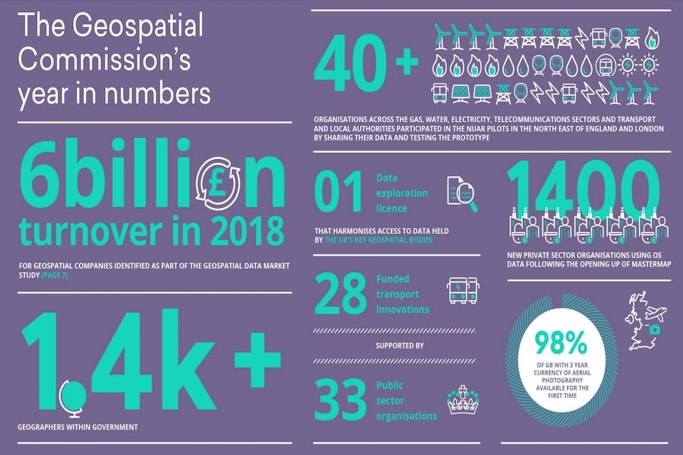
The Geospatial Commission’s year in numbers:
- 6 billion turnover in 2018 - For geospatial companies identified as part of the geospatial data market study
- 1.4k geographers within government
- 40 plus organisations across the gas, water, electricity, telecommunications sectors and transport and local authorities participated in the NUAR pilots in the North East of England and London by sharing their data and testing the prototype.
- 1 data exploration licence - that harmonises access to data held by the UK’s geospatial bodies
- 28 funded transport innovations
- Supported by 33 public sector organisations
- 1400 new private sector organisations using OS data following the opening up of mastermap
- 98% of GB with 3 year currency of aerial photography available for the first time
01 - Unlocking the power of location - the changing context
The UK’s 5-year Geospatial Strategy contains the first steps towards a location-powered UK. Technology is changing rapidly, so the Strategy adopts a flexible, iterative approach to delivery rather than a fixed plan from the outset. For the Geospatial Commission to help achieve this vision for the UK, we will stay alert to global and market changes, try new ideas, assess impact and continuously gather evidence of the latest innovations, including from overseas.
The potential for location data to support growth and sustainability reaches across almost all parts of the economy and society. The UK Geospatial Strategy outlined nine location data opportunities where location data will have a significant impact on people’s daily lives. Since publication of the Strategy in June 2020, there has been a worldwide acceleration in innovation and adoption of data-driven technology. At the same time, global events have increased the imperative to unlock value from location data.
Location data will play a critical role in the significant current and future policy challenges:
-
Supporting economic recovery
-
Helping meet net zero targets
-
Underpinning the UK’s place as a leading digital nation
-
Driving the transition to a data-driven public sector
Economic Recovery
The impact of Covid-19 on the global economy has been profound. While continuing to respond to the immediate impacts of the pandemic, countries are increasingly turning attention towards economic recovery.
In the UK this includes ensuring that we not only build back better, but that we build safer and fairer, equalising the opportunities across the UK. The UK has a plan for growth that focuses on three pillars of investment as the foundation for economic recovery: transforming our infrastructure, investing in skills, and supporting innovation. The UK’s National Data Strategy makes clear that data will be a driving force behind this growth, boosting productivity and creating new businesses and jobs.
Location data already contributes billions of pounds to the UK economy. The Geospatial Data Market Study [footnote 6] identified almost 2,000 geospatial firms operating in the UK, dispersed across many sectors and industries. The increased uptake of positional datasets (e.g. from Global Navigation Satellite Systems such as GPS, or mobility data) has driven growth in consumer services, providing additional opportunities such as fitness applications that track our daily workouts, and takeaway delivery services with real-time updates. The use of standardised, high resolution data about the built environment is bringing productivity gains in our infrastructure sector, and complete ‘digital twins’ – realistic digital representations of physical systems – have huge potential to automate and optimise services. Location data is also helping ensure the benefits of economic growth are felt by all members of society. For example, transaction data is informing analysis of regional inequalities, and mobility data is informing investment in local level infrastructure, supporting the government’s strategic agenda to level up the UK.
The Geospatial Commission will continue to drive economic value through activity planned across the four Geospatial Strategy missions and covering many of the nine geospatial opportunity areas. A key action for 2021/22 will be to commence work on building a National Underground Asset Register (NUAR), following the successful pilot projects in the North East and London. NUAR will reduce the cost of accidental utility strikes, estimated at £1.2 billion each year, and bring significant cost-saving efficiencies across the infrastructure sector.
Case Study: National Underground Asset Register (NUAR)
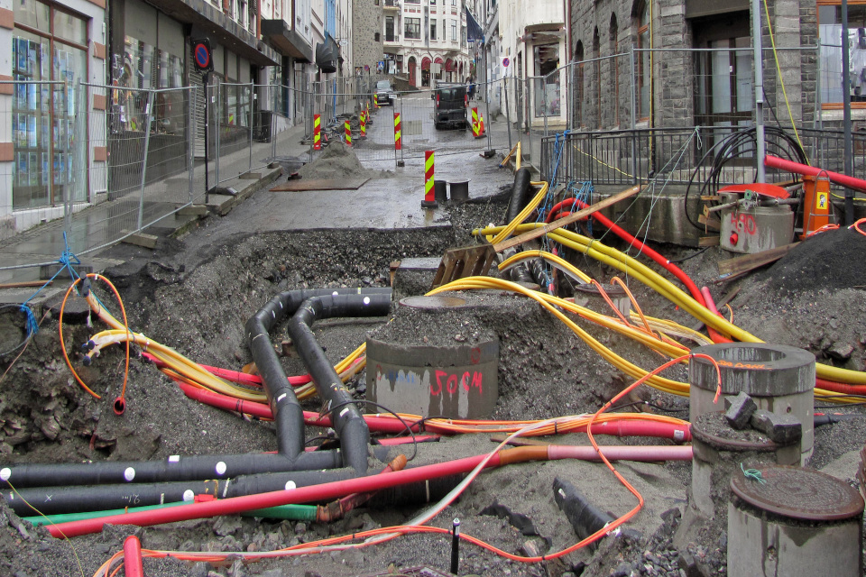
dug up road showing underground pipes
The UK does not have a uniform, digital process for sharing data about underground assets such as pipes, cables and ducts. This data is held separately by over 600 private and public sector organisations in varied formats, scales and degrees of quality. This means prior to works being carried out, each organisation is required to commit time and resource to source asset information from anyone who has or may have had assets in the area, wait for each to reply, then compile the data (often received as PDFs) into a packet that can be used by planners and excavators.
The data sharing challenges associated with utility data being held separately by each owner of underground assets means that the creation of a standardised and interactive digital platform will require involvement from government. The UK is leading the way in establishing this shared, safe and secure data asset, learning from work carried out in the UK and internationally, such as the VAULT[footnote 7], KLIP[footnote 8], and KLIC systems[footnote 9], where others look on with interest.
Once NUAR is built, planners and excavators will have efficient access to the data they need, when they need it, to carry out their duties safely and effectively. NUAR will reduce the time it takes to source data, which will result in efficiencies in the planning and development process. Excavators will also more easily be able to orientate themselves on site and view critical information in a unified and secure manner. This will help improve worker safety while also ensuring they have greater access to data when responding to emergency situations. Through these efficiencies, significant benefits, of more than £245 million each year, are expected to individual owners of underground assets and the wider UK economy.
Net Zero
Economic success and environmental responsibility go hand in hand. As the world recovers from the impacts of coronavirus, there is a transformative opportunity for the UK to build back greener and protect the environment from the impact of climate change. Global leaders have agreed to step up efforts to mitigate against and adapt to climate change impacts, and make the necessary financial commitments to encourage climate-resilient development. This year, through the UK’s presidency of COP26 and the G7, the UK Government is drawing international attention to the role of data and digital in tackling climate change and improving understanding of other environmental issues such as global biodiversity loss.
The UK is already leading the way. Climate change is the UK’s top international priority[footnote 10], and the UK has announced it will set the world’s most ambitious climate change target into law, to reduce emissions by 78% by 2035 compared to 1990 levels[footnote 11],. Reaching this target will require bold action. The Prime Minister’s Ten Point Plan for a Green Industrial Revolution[footnote 12], will mobilise £12 billion of government investment to create and support up to 250,000 highly-skilled green jobs in the UK, and spur over three times as much private sector investment by 2030. The National Infrastructure Strategy provides a vision for how the UK’s infrastructure must adapt to reach net zero 2050 - across power, heat and transport networks. The forthcoming Net Zero Strategy and Heat and Buildings Strategy will continue to build on the UK’s climate change ambitions and set the path to net zero.
Location data and technologies will contribute to the UK’s pathway to net zero. Earth Observation data can provide near real-time monitoring of carbon emissions, including estimates of the carbon footprint of individual buildings and facilities. Satellite navigation, telematics and fleet management systems can help ensure the efficient use of transport networks, reducing journeys times and thereby fuel emissions. Marine geospatial data can be used to identify the best sites for offshore renewables, and to continuously monitor and enhance their productivity.
The Geospatial Commission will continue to focus on the environment as one of the nine location data opportunity areas and as a cross cutting benefit of location data. A key action for 2021/22 will be to develop the UK Geospatial Strategy commitment to improve data about land use through regional and national pilots, enabling joined up policy making and supporting the transition to low carbon uses of land while achieving other national priorities including housing development.
Case Study: Mapping tool reveals heat stored in abandoned coal mines
Geothermal energy from mines could provide a sustainable, local and low cost energy source

illustration showing houses and water underground
One quarter of the UK’s population live above abandoned coal mines. The mines are warmed by natural geothermal processes and the warm water within them is now seen as a viable new form of sustainable energy with the potential to play a vital role in making homes and public buildings greener, warmer and more energy efficient.
To understand the potential of mine heat more effectively, the British Geological Survey and the Coal Authority collaborated to combine existing mining information and temperature data to create a series of GIS layers in an interactive map.
This interactive map shows where the mines are located and the extent by which temperatures increase with depth in different regions of the coalfield. It also highlights areas where warm water is already being abstracted by pumping, raising awareness of opportunities to harvest heat without the need to drill boreholes into the mine workings.
The interactive map was released in December 2020 and is freely available to use by developers, planners and researchers to identify opportunities to investigate the use of mine water.
It is the first time the data has been brought together in this way, and illustrates the long-term feasibility of heating homes and buildings using this sustainable heat source.
Digital Nations
Technologies are advancing at a scale, speed and complexity that is unprecedented. Over the next twenty years, the global technological revolution will advance at pace. Artificial intelligence is accelerating scientific discovery. The UK is taking a quantum leap into new territory, for example, harnessing sensors to detect light, gravity and magnetic fields so that objects can be seen in a manner that they have not been seen before. The advancing CleanTech sector is pushing scientific discovery and integrated supply chains to provide for the long-term sustainability of the planet.
The UK is investing in innovation and new technologies to drive growth, build competitiveness in the digital age and enable net zero. The UK has a strong and clear ambition to secure its status as a Science and Tech Superpower by 2030[footnote 13]and the world’s number one data destination[footnote 14]. The UK’s strategy to Build Back Better[footnote 15] announced £14.6 billion for research and development to enable innovation as a pillar for growth. Developing new technologies continues to be at the centre of government’s plans to deliver net zero[footnote 16] and to transform UK infrastructure[footnote 17]. The forthcoming Innovation Strategy will outline how the UK will achieve its ambitions in innovation and where to focus its efforts over the next decade.
Advances in use of location data are helping fuel this technological revolution. The UK Geospatial Strategy set out six location data trends that underpin the nine opportunity areas: growth in real-time data, sensors, artificial intelligence, cloud and edge-computing, connectivity and 5G future and data visualisation. Data acquisition and exploitation is critical to making emerging technologies applicable in the real world.
The Geospatial Commission will continue to maximise the commercial opportunities for innovation and promote market-wide adoption of high value emerging location technologies through our work to deliver Mission 4 of the Geospatial Strategy: Enabling Innovation. A key action for 2021/22 will be to run Phase 2 of the Transport Location Data Competition, investing up to £4m to support high quality projects from the successful first phase of the competition. Projects will cover a diverse range of applications and develop the selected projects to near-market ready solutions.
Case Study: Smart Ports

sea port and large container ship
As an island nation, ports serve a vital function in the UK’s supply and logistics networks. Around 90% of the UK’s trade by volume for instance is carried at sea[footnote 18]. As the UK looks to recover economically from Covid-19, to maintain existing and foster new trading relationships, optimising the way ports are managed will ensure the UK remains a competitive global leader, maintains a thriving export market, and continues to streamline access to imported goods.Geospatial data and services can provide significant benefits to port operations - from measuring current berth occupancy and assigning ships to available berths to load / unload cargo; tracking the movement and storage of cargo in real time; to aiding in port design and expansion planning.[footnote 19]
There are a number of Smart Port projects underway in the UK[footnote 20], with opportunities to engage and learn from international partners. The UK Hydrographic Office worked with the Port of Rotterdam and other industry leaders as part of the Port Call Optimisation Task Force.[footnote 21] This project established a new universal data standard for port calls, including such critical information as arrival and departure times, and water depths, to support smart port operations. The Port of Rotterdam has recently announced a partnership with PD Ports to introduce smart port solutions to Teesport. This will accelerate the pace of digitalisation at Teesport and support the smooth flow of trade between the UK and the Netherlands.
Data Driven Public Sector
The challenges of the last year have led to a renewed global emphasis on the need for a coordinated policy approach to data, including geospatial data, to improve how data informs policy development and monitors implementation.
Governments around the world are taking steps to embrace the opportunity. The US government continues to embed its Geospatial Data Act 2018[footnote 22], setting the governance and policies for geospatial data to encourage better coordination between states and better cooperation and uptake within public and private sectors. In India, the Ministry of Science and Technology has recently announced improved access to geospatial data and services held by the government to increase their quality for national planning and economic recovery.[footnote 23]
In the UK, the government has established a new Central Digital and Data Office for Government as the strategic centre for the UK’s public sector Digital, Data and Technology capability (DDAT).[footnote 24] Part of its mission will be to ensure that the public sector can better leverage data and emerging technologies. The UK’s National Data Strategy underlines the importance of data in government for driving efficiency and improving public services[footnote 25]. The Centre for Data Ethics and Innovation has reflected on the use of location data in supporting the delivery of local services during the pandemic (Centre for Data Ethics and Innovation, 2021). The Digital Strategy for Scotland and Digital strategy for Wales both highlight the value of high quality data in redesigning public services and will help us to learn from each other.
Location data is a significant part of the UK data capability and policy agenda. There is a growing recognition across the public sector of the benefits of high quality location data to support statistical analysis, policy development and critical operations. The UK government is committed to putting data and analysis at the heart of decision-making for the public sector. For example, the Government Property ‘InSite’ system will ensure public sector land and built assets, valued at £515 billion, are managed strategically to help tackle priorities such as addressing climate change, levelling up and improving efficiency. Access to location data, including through the £1 billion 10-year contract for public sector access to Ordnance Survey’s foundational location data, has been crucial in supporting the UK Government’s response to the coronavirus pandemic where foundational geospatial data has been used to contextualise aspects such as vaccine rollout and case numbers.[footnote 26] Emerging considerations about data sharing for the public good can lead to the broadening of access to new and innovative forms of valuable location data held outside of the public sector, further improving public services.
The Geospatial Commission will continue to drive improvements to location data quality and use in government. We will be taking further critical steps towards enhancing UK public sector location data assets, publishing the first comprehensive assessment of national location data assets held by our six Partner Bodies against the ‘Q-FAIR’ principles we have developed collectively.
Case Study: Preventing tropical forest loss through coordinated access to location data
Two satellite images showing increased deforestation in Colombia - the brown areas have been deforested. The top image is from November 2020 and the bottom image from February 2021 which shows an increase in brown deforested areas: Imagery ©2021 Planet Labs Inc.
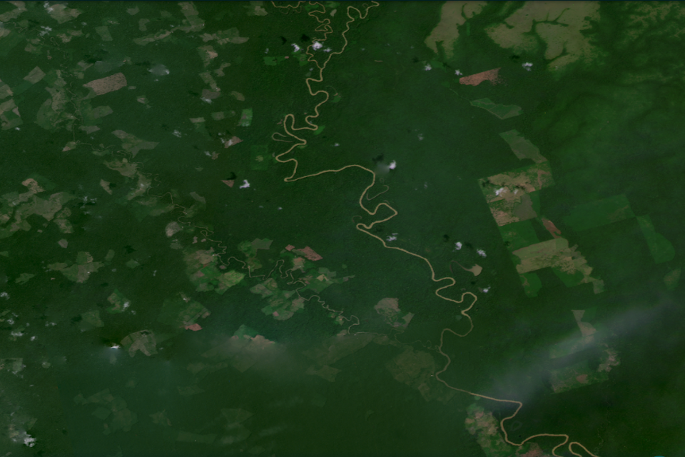
bird's eye view of forest area
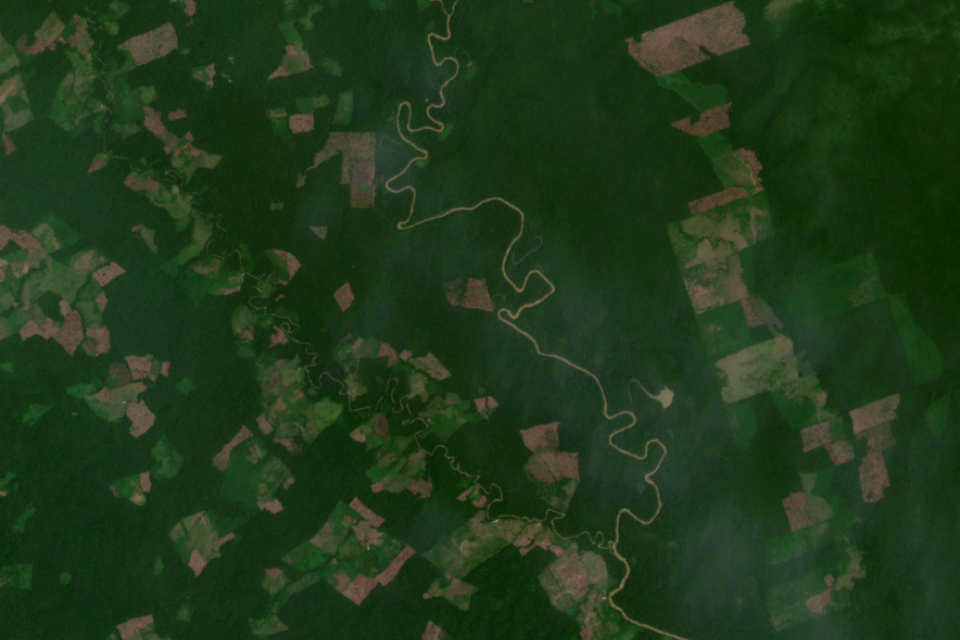
Deforestation
Around the world, government’s are pioneering innovative methods of location data access to help tackle some of our key, shared global challenges. The Norwegian Ministry of Climate and Environment has recently funded the first ever global tropical forest programme [footnote 27] initiative to provide more detailed, high resolution earth observation data to both public and private sector users. Forests capture and store carbon from the atmosphere, and the deforestation of tropical forests is a large source of greenhouse gas emissions[footnote 28]. In order to meet climate change targets, halting tropical deforestation and increasing forest restoration is required.
To date nearly 6000 users are signed up to access the program from over 120 countries, including the UK. Awarded to KSAT with its partners Planet and Airbus, Norway’s International Climate and Forest Initiative (NICFI) data program provides open access to historic and current high resolution satellite image mosaics, each mosaic covering a vast area of 45 million sq km. By simplifying licensing conditions it could open up more opportunities to facilitate and foster initiatives in pursuit of reducing deforestation.
02 - Mission Updates
The UK Geospatial Strategy has a vision for a coherent location data framework by 2025, delivered through the Geospatial Commission’s four strategic missions. This section provides an update on progress against the Strategy commitments and plans for the year 2021/22.
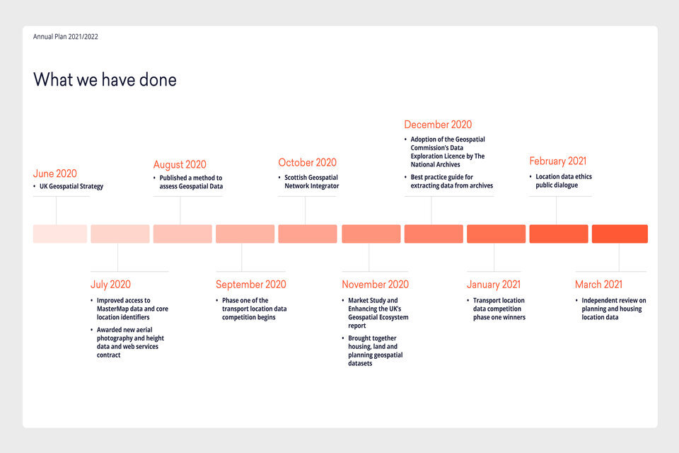
What we have done
What's next
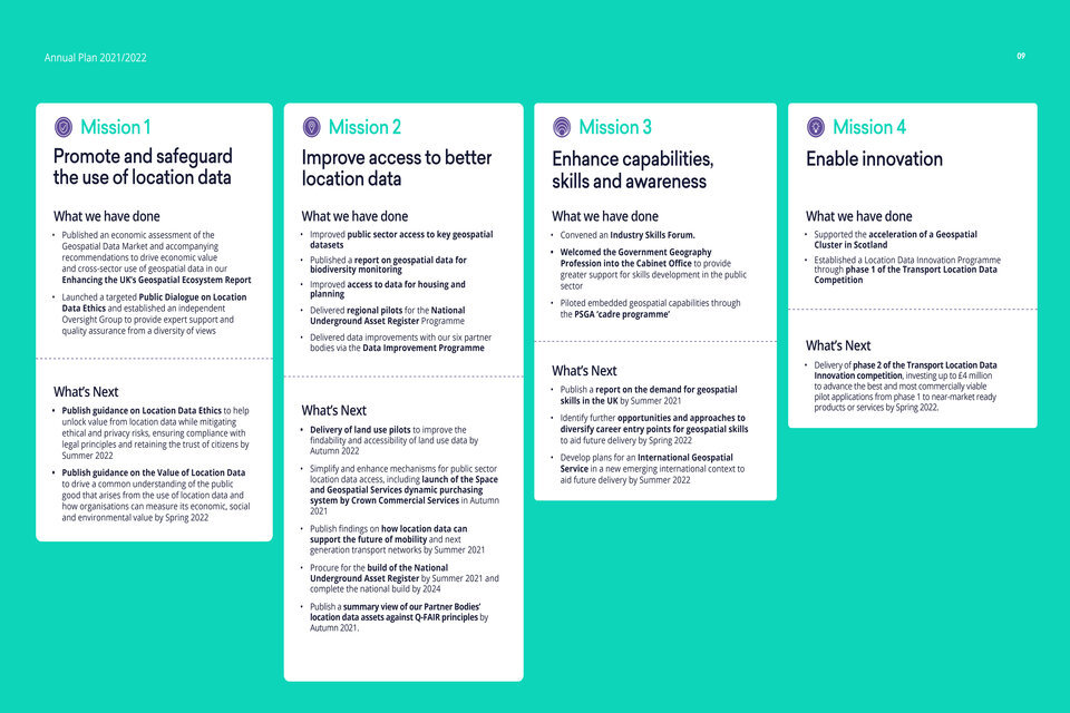
Mission 1: Promote and safeguard the use of location data
In order to unlock the power of location, we need to provide an evidenced view of the market value of location data, set clear guidelines on data access, privacy, ethics and security, and promote better use of location data.
What we have done
Published the Geospatial Data Market Study alongside our Enhancing the UK’s Geospatial Ecosystem report.
In November 2020, we published an independent report to develop the first comprehensive assessment of the current and potential future value of the UK’s geospatial economy. The report concluded that the geospatial market is a key enabler of activity in other markets across the economy meaning that it is best described as an ‘ecosystem’, and its value is accordingly difficult to measure.
Alongside the Geospatial Data Market Study, we published Enhancing the UK’s Geospatial Ecosystem, outlining six Geospatial Commission recommendations needed to nurture the UK’s growing geospatial economy and realise the full potential of location data to the UK. These recommendations, additional to activities announced in the UK Geospatial Strategy, relate to three key areas of action: improving access to location data, maintaining public trust, and driving location data adoption.
Enhancing the UK’s Geospatial Ecosystem recommendations
| Improving access to location data | |
| Action 1 | The Geospatial Commission will include the objective that ‘data holders consider the public good in decisions about access to location data’ in its forthcoming guidelines for measuring the value of location data, and for the ethical use of location data and technology in both the private and public sector. |
| Action 2 | Competition regulators, including a future Digital Markets Unit [footnote 29] and organisations within the Digital Regulation Cooperation Forum[footnote 30], consider the potential public good arising from the sharing and reuse of location data when evolving their regulatory approach for unlocking competition in digital markets. |
| Maintaining public trust | |
| Action 3 | The Information Commissioner’s Office (ICO) should provide further clarity on the distinction between personal and non-personal location data. |
| Action 4 | The Geospatial Commission will lead an informed public discourse about the benefits and risks of new applications of location data, starting with a new programme of deliberative public engagement. |
| Driving location data adoption | |
| Action 5 | The Department for Business, Energy & Industrial Strategy (BEIS) should further incorporate location data capability as an essential component of their programmes for increasing growth, innovation and productivity within the UK economy. |
| Action 6 | The Government Commercial Function should embed provisions within appropriate government contracts and spend approvals to require valuable location data, generated either directly or as a by-product of the provision of other goods and services, to be retained and made available for appropriate reuse by the government. |
We maintain an open dialogue with organisations outside of the Geospatial Commission that are responsible for delivering specific recommendations. The Government has also established a Digital Markets Unit (DMU) within the Competition and Markets Authority (CMA), to begin work to operationalise a new pro-competition regime for digital markets. BEIS will be undertaking a pilot project, subject to funding, to bring together a diverse range of geospatial and other data sources to help inform net zero policy making.
Launched a Public Dialogue on Location Data Ethics
To benefit from the widespread use of location data it must be used in a way that mitigates concerns and retains public confidence. We have partnered with public dialogue and data specialists Sciencewise, Traverse and the Ada Lovelace Institute in a new project that will open a conversation with members of the public to gather evidence about public perceptions of location data use. An Oversight Group will provide expert support and quality assurance from a diversity of views[footnote 31]. We intend to publish the final report covering findings from the dialogue at the end of 2021.
| What is a public dialogue? | Public dialogue is an approach to involving citizens in decision making. Dialogues bring together a diverse mix of citizens with a range of views and values, and relevant policy makers and experts, to discuss, reflect and come to conclusions on complex issues. |
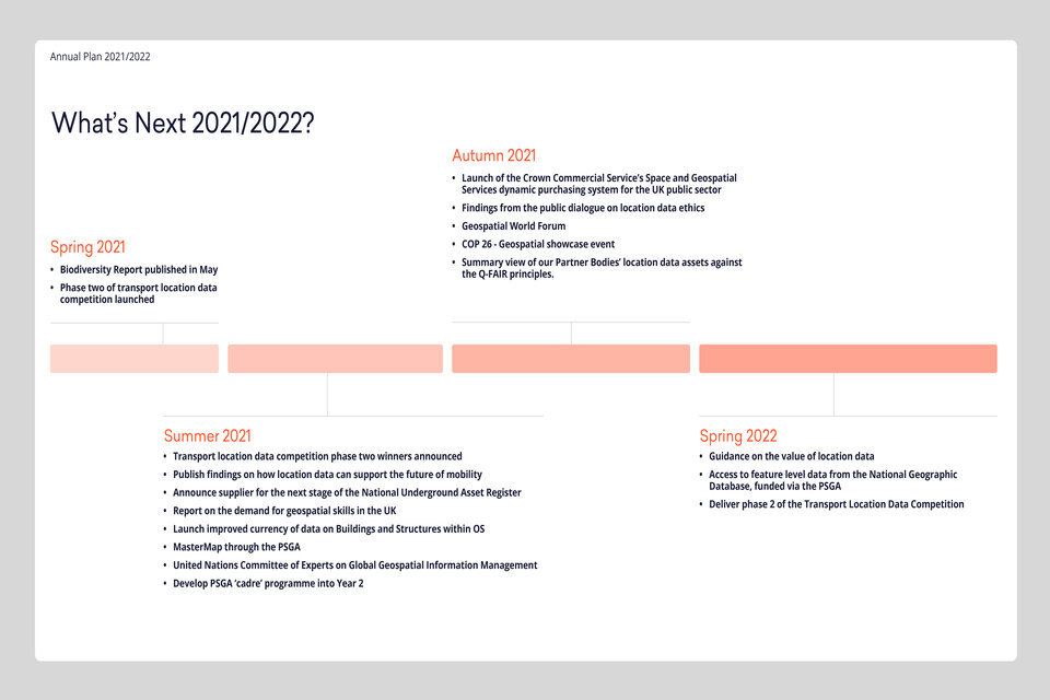
What’s Next?
Publish Guidance on Location Data Ethics by Summer 2022
The UK Geospatial Strategy included a commitment to publish guidance on how to unlock value from location data while mitigating ethical and privacy risks, ensuring compliance with legal principles and retaining the trust of citizens. This guidance will be informed by our public dialogue and will be relevant for all organisations that use location data, including private sector, public sector, academia and civil society organisations.
We will consider ways to explore the findings of the public dialogue more broadly such as through surveying the general public and in alignment with the Centre for Data Ethics and Innovation. We will continue to engage a wide range of organisations as we develop the guidance and learn from international partners, to ensure the guidance is practical, balanced, and takes account of the fast pace of innovation in geospatial technology. The guidance will contribute to Pillar 4 of the National Data Strategy, helping ensure that data is used responsibly and Mission 2 of the National Data Strategy, securing a pro-growth and trusted data regime in the UK.
Publish Guidance on the Value of Location Data by Spring 2022
To support wider adoption and use of location data, we recognise the importance of organisations being able to articulate and value the benefits of its use. We are developing a programme of work to understand the public good that arises from the use of location data and how organisations can measure its economic, social and environmental value.
We will build on key findings from this research to explore measures that may improve location data availability across the economy, informed by a strong evidence base, including ongoing primary research led by the Office for AI to explore how data foundations can enable data availability, and DCMS’s research into ‘Increasing access to data across the economy’[footnote 32].
We plan to publish guidance in 2022, which will provide a consistent understanding of the valuation principles and highlight practical methods needed to underpin public sector investment in location data and support access to privately-held location data for the public good.
| Why is the value of location data often underestimated? | There are a number of reasons for this: users of location data, as with other forms of data, recognise its value only once they have experienced and understood its potential insights; location data is typically one of multiple inputs into decision-making which makes it difficult to isolate its sole value, and; the benefits of location data can be generated beyond its initial use and purpose, meaning the full extent of its value is not well understood. The hidden value of location data can be observed through its role in the ‘Places’ strand of the Government’s Covid-19 vaccine delivery plan. The growing network of vaccination sites has been formed using key location data such as population density, to ensure that everyone lives within 10 miles of a vaccination centre. [footnote 33] |
Case Study: Guidelines will unlock the value of mobility data

socially distanced people in a train station
Mobility data has been a vital resource in the UK’s response to Covid-19, with enhanced recognition of its value as a dataset across a range of use cases.
Examples include:
-
The Office for National Statistics (ONS) Data Science Campus has used anonymised mobility data to monitor the impact of non-pharmaceutical interventions on the spread of Covid and on the UK economy. They made use of telecoms mobility data to develop metrics in collaboration with other government departments on aspects such as travel flows between local authorities, journeys by age, gender and purpose and measures of compliance with local restrictions.
-
In Scotland, an initiative led by Administrative Data Research Scotland is working to enable public sector organisations to measure the extent of mobility and how this compares during the pandemic period to levels of mobility in normal times. This data will be used as part of a project to understand the household, housing and neighbourhood risk factors for COVID-19.
There is strong growing demand for mobility data to improve public service delivery by developing indicators of near-real-time populations and population movement such as travel-to-work areas and commuter flows, international travel, tourism and internal migration, and also for better operational information (for example, real-time information around large events). More timely and granular statistics derived from mobility data could drive new insights on the impact of mobility on local economies and levelling up, public health, net zero, and support local planning requirements. To benefit from mobility data and the applications it enables, it is important that it is used in a way that retains public confidence. The Geospatial Commission is considering this through a planned public dialogue and the development of guidance on location data ethics.
Mission 2: Improve access to better location data
We will streamline, test and scale the development of new and existing location data ensuring it is findable, accessible, interoperable, reusable and of high quality.
What we have done
Improved public sector access to key geospatial datasets
Location data is increasingly critical to public sector operations, policies and planning and demand for high quality location data to support emergency response has surged over the last year.
The Geospatial Commission’s public sector contracts portfolio provides the whole of the public sector with access to critical foundational data that supports the development of robust location-based policies and delivery of effective and efficient public services where they are needed most. Over the last 12 months we have replaced, renewed, and upgraded all of our public sector wide contracts for Ordnance Survey data, aerial photography and height data, and access to the Postcode Address File. We have ensured that all of these datasets are accessed by the public sector on the same licensing terms so as to enable seamless use. This includes enabling users to derive and share information from across the data products portfolio with the rest of the public sector and beyond.
The first year of the new Public Sector Geospatial Agreement (PSGA) with Ordnance Survey and the new Aerial Photography GB (APGB) agreement with Bluesky, Getmapping and Airbus has seen improved access to data, activities including:
- Improved ease of access to Ordnance Survey data through the OS Data Hub and introduction of delivery Application Programming Interfaces (APIs) (removing the data management overhead) has been used by 1,151 users in 333 organisations since going live in January 2021
- Temporary Ordnance Survey data licences for COVID-19 response issued to 43 organisations
- Ordnance Survey deployed Mapping for Emergency resources to 19 organisations, supporting the response to issues such as the pandemic and flooding
- APGB delivered 107,712 sqKM of updated high resolution aerial imagery captured in 2020, bringing 98.4% of the data up to date to within three years since capture
- Launch of the new web services for the APGB datasets, accessed by 341 public sector bodies.
The PSGA goes beyond just the data and is contributing towards the delivery across all missions of the UK Geospatial Strategy. For example, increased access to the OS expertise to support the building of geospatial capability within the public sector and training for both primary and secondary school teachers on opportunities to use mapping with students.
Access to PSGA data has also been used to drive further value across the UK’s nations. For example, the Welsh Government has delivered a ‘once-for-Wales’ platform delivering data services from a single source and creating cost savings from minimising the development of other similar public sector portals. The platform uses PSGA data to form the base mapping on which other data can be displayed and linked. It is currently in beta and has been used to rapidly deploy pan-Wales location-based services such as Active Travel and COVID-19 related services, interfacing with existing geospatial tools.
Published a report on geospatial data for biodiversity monitoring
We published a research study of the species data landscape in England. The review was carried out by a consortium led by eftec (Economics for the Environment), supported by eCountability, ALERC (Association of Local Environmental Records Centres), the Biological Records Centre (UKCEH) and the NBN (National Biodiversity Network) Trust. The study explores the collection, funding and provision of species data at different levels and assesses options to make species data more consistent, joined up and accessible. The scope includes all types of species data including marine, freshwater and terrestrial species.
Improved access to data for housing and planning
The UK Geospatial Strategy committed to improve access to better data that enables housing development and improves the house buying and selling process across the UK.
| Why Housing and Planning? | Location data-driven innovation has the potential to boost productivity across the housing market, such as helping to identify locations for development, reducing failure rates in the conveyancing process or improving the process to develop and use local plans. In order to improve productivity in the market, data inefficiencies must be addressed by influencing data owners to make their data more findable and accessible, proactively identifying possible solutions and, where appropriate championing other organisations who are better placed to deliver tangible solutions that support the UK’s future housing needs. The vast number of actors within the housing and planning space adds a level of complexity to any proposed intervention. Key organisations include the Ministry of Housing, Communities and Local Government, Homes England, HM Land Registry, the Valuation Office Agency and, as housing is a devolved policy area, other lead agencies across the UK. |
Through our work to date we have:
-
Released Unique Property and Street Reference Numbers (UPRNs and USRNs) in 2020 under an Open Government Licence. We are working with the Ministry of Housing, Communities and Local Government and other key organisations to drive the uptake and adoption of the UPRN and USRN identifiers.
-
Created the ‘Bringing together housing, land and planning geospatial datasets’ webpage which signposts site visitors to relevant open data sets. It also includes a downloadable register containing links and licensing information for over 400 datasets and portals.
-
In March 2021, an ‘independent ‘Planning and Housing Landscape Review’ was published, completed by SEC Newgate Research.It takes stock of how relevant housing data is currently being accessed and used, what the main challenges and opportunities are and whether more can be done to unlock greater insights and economic value for the UK.
What’s Next?
Delivery of land use pilots to improve the findability and accessibility of land use data by Autumn 2022
The UK Geospatial Strategy committed to work with key organisations to identify a targeted approach to support a national land use framework.
Land is a finite resource that faces competing demands from housing, infrastructure, farming, food production, geothermal potential, underground mineral resources, carbon sequestration, flood protection and habitat creation. Demands on land are set to increase and evolve with the need to reach net zero greenhouse gas emissions, build more homes, and in the next five years deliver over £600bn of infrastructure investment. To reconcile these competing demands and make the best use of our land, decision makers at national and local level need access to better data about land use. At present, there is no easy way to get a clear picture of our land and its biodiversity to understand current use, potential use, and the impacts of different choices at local or national levels.
In 2021/22, we will work in collaboration with the key land policy owners to develop pilots to help improve access to data on land use while demonstrating how a joined-up approach to data could support more coordinated policy making and local delivery. The pilots will bring together our evidence gathering work on biodiversity and housing and planning data through three pilot projects that will:
- Identify the datasets required to enable effective decisions concerning land use to be made.
- Engage the relevant data producers and work with them to incorporate the Q-FAIR principles and relevant standards into their dataset(s).
- Pilot an authoritative data platform in the UK as the single source for data about land use, including through simplified licensing, enhanced searching and filtering capabilities, a rich metadata store, and data visualisation.
Simplify and enhance mechanisms for public sector access to location data and services from the market
In the UK Geospatial Strategy, we committed to explore the rationalisation of the procurement of Earth Observation data. We are engaging with key public sector organisations to understand the demand for remote sensed data and other data sets, such as mobility data, to identify access mechanisms and to help the public sector act as an intelligent customer of geospatial data and services.
As part of this, we are contributing to Crown Commercial Service’s (CCS) creation of a Space and Geospatial Services Agreement within their newly-created space category for public sector procurement. This agreement will provide the public sector with a more efficient way to procure access to geospatial data and services from the market. Moreover, we are working to ensure that data procured through this route is as Q-FAIR as possible.
Launch of improved currency of data on Buildings and Structures within OS Mastermap through the PSGA
Ordnance Survey will introduce improved currency of Buildings and Structures within OS MasterMap, and commence capture of new data on buildings, land use and land cover, transport, and an Emergency Services Gazetteer. We will also be working closely with OS and the public sector to further build capability and expertise in the use of the data to deliver better outcomes for the public.
Publish findings on how location data can support the future of mobility and next generation transport networks by Summer 2021.
The UK Geospatial Strategy outlined a commitment to assess how location data can support the future of mobility and next generation transport networks. A key activity is our investment in a Transport Location Data Innovation Competition, and further detail is outlined under Mission 4: Enable Innovation. In parallel to our investment, we have also continued to develop evidence for future priorities, engaging widely with industry and academia to understand location data access barriers and opportunities in the transport sector. We have held a series of roundtables, with over 50 organisations from across the public and private sector, and commissioned an academic consultation engaging with over 20 academics based in the UK and abroad. We will publish our findings in summer 2021.
Procure for the build of the National Underground Asset Register by Summer 2021,and complete the national build by 2024
The UK Geospatial Strategy and the National Infrastructure Strategy (pdf, 5.2 MB) set out the economic opportunity presented by the creation of a National Underground Asset Register. With the help of owners of underground assets, including utilities and local authorities, we have tested the feasibility of creating such a register through the launch of two pilots, one in the North East of England and the other in London. We have learned from similar international services and have identified the legal, commercial, safety and security requirements needed to deliver a comprehensive digital platform for planners and excavators.
In 2021-22, the Geospatial Commission will commence work on a production platform. We will start by building a regional minimal viable product for three regions, the North East of England, Wales and London. In future years, the platform will be enhanced and rolled out nationally. The National Underground Asset Register will allow digital access to data from across the water, electricity, gas, telecommunications and transport sectors. It will also include valuable planning datasets. It will act as a single source of data for use by planners and excavators from across the UK.
Applying a ‘Q-FAIR’ approach: Spotlight on improving the UK’s public sector location data
The UK public sector holds vast quantities of valuable foundational geospatial data. As technology evolves and applications for this data increase, the data collected and curated by the public sector will play an increasingly critical role in everyday life. Over the last two years, in parallel to upgrading the specification for public sector access to Ordnance Survey data through the public Sector Geospatial Agreement, the Geospatial Commission has invested in delivering priority data improvements, focussing on geospatial data held by our six Partner Bodies.
We now intend to expand the scope of our ambitions for UK public sector geospatial data improvements. As a starting point, we are developing an assessment tool in collaboration with our six Partner Bodies, to support public sector organisations to credibly reflect on the current quality of the geospatial data they hold, whether it is easy to find and access, and whether it interoperates and is reusable with other data. This assessment tool will allow us to apply ‘Q-FAIR’ standards to public sector geospatial data.
What we have done
Delivery of the Data Improvement Programme (DIP)
Over the past two years, the Data Improvement Programme has been widely supported and valued by our partners and the broader geospatial community. It follows the principles of a FAIR[footnote 34] data model, and has already delivered some significant data improvements aimed at fixing the foundations of geospatial data held by our Partner Bodies, including:
- Developing a harmonised Data Exploration License for our Partner Body data assets to enable anyone to freely access their data for research, development and innovation purposes
- Establishing a core set of Partner Body licensing principles for ongoing review using a shared language and definitions, to improve licence compatibility and allow end users to more easily combine data
- Identifying and selecting standards for Partner Body metadata records and catalogue services to allow greater interoperability between datasets
- Establishing a data sharing agreement between the Partner Bodies to improve access and interoperability of data, and structures
- Building an alpha service - the Correlation Relationship service - that allows the authoritative join between two datasets to be shared and published
- Publishing best practice guidance around archive data capture and digitisation, to support considerations for further work to explore the use of new technology (such as machine learning and natural language processing) and crowdsourcing as means to extract useful insight from archived data more efficiently.
- Improving our understanding of the UK’s coastlines through a project focused on understanding the data landscape of agencies involved in the collection and use of geospatial data in the coastal zone.
What’s Next?
Promote the work of the Data Improvement Programme
In partnership with our Partner Bodies, the Geospatial Commission will promote the work conducted through the Data Improvement Programme to share our best practice and lessons learned.
Publish a summary view of our Partner Bodies’ location data assets against Q-FAIR principles, including a collective vision for the future state of UK geospatial data and provisional recommendations to reach it, by Autumn 2021.
The UK Geospatial Strategy introduced the Q-FAIR model as a means of considering and capturing priority improvements to geospatial data.
Quality
Quality means that data is fit for its intended purpose, is based on appropriate methods, and is not materially misleading. There are many ways to measure quality: for example accuracy, precision, timeliness, coherence and completeness.
Findability
To be used, data has to be findable. Data should be easy to find for both humans and computers, and able to be integrated easily with other data to draw insights.
Access
The complexity of the licensing of public sector datasets has been cited as one of the major barriers to the use of data. Data must be accessible in order to be useful.
Interoperability
Making use of datasets in combination with one another is critical to ensuring their wider impact and value through higher quality insights.
Reusable
Ensuring that high quality datasets can be reused across a range of use cases is critical to unlocking value.
The Q-FAIR tool, as it develops and is applied, will aid with the creation of a shared vision for the future state of the UK’s core public sector geospatial data. This approach will move the UK towards more regularised and proactive methods for creating, providing and procuring high value geospatial data, and help us monitor and evaluate the UK’s progress over time, as the application of the tool extends to other organisations holding geospatial data in the UK.
The results of the Q-FAIR assessment will support the UK to:
- Showcase UK geospatial data strengths, good practice and improvement initiatives
- Set a benchmark to measure progress
- Identify a collective focus
- Identify key strategic gaps
Case Study: Local Land Charges

bird's eye view of roads and housing
Local Land Charges describe restrictions on land, such as planning conditions or listed building status. Searches of Local Land Charges are required in the property buying process. Currently customers can pay up to £80 and wait for up to 40 days to get this information from Local Authorities.
HM Land Registry’s (HMLR) Local Land Charges programme is designed to transform the service for homebuyers and property professionals, providing this key information instantaneously for a flat fee of £15. Working in partnership with local authorities across England and Wales, HM Land Registry is transforming 25 million items of data held to varied specifications into a standardised digital format. In improving the quality of this geospatial data, HMLR is supporting digital planning and innovation in the UK property sector.
In line with the UK Geospatial Strategy, HMLR’s programme will deliver important improvements to public sector geospatial data quality and access. Alongside this, the programme is providing valuable insight to the Geospatial Commission and other partners about the opportunities and lessons learnt in digitising data, for the benefit of future projects.
Mission 3: Enhance capabilities, skills and awareness
Develop more people with the right skills and tools to work with location data, across organisations and sectors, to meet the UK’s future needs and support global development.
What we have done
Convened an Industry Skills Forum
We have convened a Skills Forum which consists of 24 organisations who cover a range of sectors dependent on geospatial data: retail, infrastructure, public sector, membership bodies, academia, trade associations and specialist geospatial firms. This new Forum has enabled us to build a collaborative approach to enhancing the UK’s geospatial capability, considering key topics, from developing geospatial awareness at school to reskilling in the workplace, from approaches on meeting the demand for highly specialist roles to ensuring a wide awareness on the value of understanding location.
Welcomed the Government Geography Profession into the Cabinet Office to provide greater support for skills development in the public sector
Over the last 3 years, the Government Geography Profession has grown to include 1,400 members across central government, local government and arms length bodies and now operates as part of the Geospatial Commission, making the Cabinet Office its departmental home. The Profession has also become part of the Analysis Function, ensuring geospatial skills are embedded as part of this wider centre of expertise and enable the profile of geospatial skills to be raised.
Piloted embedded geospatial capabilities through the PSGA ‘cadre programme’
The PSGA includes provisions that enables the Geospatial Commission and Ordnance Survey to embed Ordnance Survey data science expertise into a small number of public sector organisations to assist them with their use and analysis of geospatial data available under the PSGA to help create insights that support the development and delivery of government policy and outcomes. Through these provisions several of Ordnance Survey’s data scientists were deployed to the Joint Biosecurity Centre (JBC) to provide geospatial insight into the JBC’s evidence-based approach and objective analysis that has informed local and national decision-making in response to Covid-19 outbreaks. Ordnance Survey’s technical experts have also been embedded with the Building Digital UK (BDUK) data modelling teams for six months to develop a new network model that uses the high quality data available to them through the PSGA. This deployment has also included a knowledge transfer to increase the overall geospatial capability within BDUK.
What’s next?
Publish our findings on the Demand for Geospatial Skills by Summer 2021
We will publish findings from a commissioned report on the Demand for Geospatial Skills in the UK. The study has focussed on analysing job postings data collected between the years 2014 to 2020 to explore demand in previously identified sectors and traditional geospatial roles. The purpose of this work is to provide a snapshot in time in understanding the demand for geospatial skills, an area we know is changing rapidly.
Identify further opportunities and approaches to diversify career entry points for geospatial skills to aid future delivery by Spring 2022
We will engage with training providers, employers and institutions, to encourage augmentation of other career pathways, such as data and digital, enabling a diversified approach to embedding geospatial skills. Career pathways act as a map to guide individuals to find their way to gainful employment and a successful career. They provide multiple entry and exit points to allow progress from early education to retirement and signpost the skills and competencies needed along the journey. With the Skills Forum members, we will continue to advocate for the value of geospatial skills across sectors, identify approaches to embed geospatial skills into the wider data and digital skills landscape, evaluate diversity within the geospatial workforce and address under-representation.
Develop plans for an International Geospatial Service in a new emerging international context to aid future delivery by Summer 2022
International trade and technological development is evolving rapidly, we will work with the lead policy organisations to ensure that plans for an International Geospatial Service reflect the rapidly changing context and take advantage of the opportunities to forge new productive relationships with international partners.
Case Study: UK Space Sector Skills Survey highlights industry shortage

view of the United Kingdom from space
The UK Government and the space industry have ambitions to capture 10% of the global space market by 2030, which is estimated to be £400 billion[footnote 35]. While the industry is growing, more than 3% annually in the UK[footnote 36], the supply of relevant skills to support future growth presents a challenge. Data captured from sensors and satellites in space are an important source of geospatial information and incredibly powerful when combined with other data sources.
The UK Space Agency (UKSA) commissioned the Space Sector Skills Survey 2020 (pdf, 3.4 MB) to gather information on the sector’s recruitment and training practices. The results of the survey suggest that there is a mismatch between the skills industry needs and the skills the UK Higher Education system produces. Nearly half of businesses reported that the training they needed in specialist topics, technical subjects or management and commercial skills was either missing or in short supply.
The space industry is reliant on skilled professionals with expertise ranging from hardware development to the diverse applications of space derived data. The survey identified geospatial skills to exploit uses of space data which are becoming essential components of a wider range of skill sets, but are facing similar shortages. These skills included geospatial data analytics, satellite imagery processing and data science capability.
Identification by businesses and stakeholders across the space sector of future skills requirements is enabling learning providers to support the UK to develop more professionals, benefitting a wide range of organisations and sectors.
Mission 4: Enable Innovation
Maximise the commercial opportunities for innovation and promote market-wide adoption of high value emerging location technologies
What we have done:
Supported the acceleration of a Geospatial Cluster in Scotland
The Geospatial Commission, with Scottish Enterprise and the Scottish Government, launched Location Data Scotland in October 2020, with a £200,000 joint investment. The initiative is aiming to foster a high growth, competitive and better functioning geospatial market in Scotland, which will help generate funding opportunities and stimulate inward investment, resulting in increased commercial uptake of location data. It has already driven strong engagement within the geospatial community and also with wider industries and organisations within Scotland.
Location Data Scotland will continue throughout 2021/22 and we will monitor its impact on the Scottish geospatial ecosystem.
Established a Transport Location Data Competition
We established a Transport Location Data Competition to bring together transport data challenges and innovators in order to deliver novel solutions, investing £2 million into Phase 1 launched in September 2020 with Innovate UK. The SBRI competition focussed on solutions for four thematic challenge areas:
- Mobility as a service - Overcoming siloed transport networks by enabling more seamless and accessible integration of transport modes
- Active travel - Mitigating safety risks to promote active travel
- Supply chains - Tackling logistical challenges such as planning distribution networks and routing, optimising storage and warehousing, and last-mile delivery to reduce freight transport costs.
- Increasing capacity - Managing over-capacity to increase efficiency of our transport networks without compromising safety
Phase 1 of the competition received 190 high quality applications. The 28 most innovative ideas were awarded funding to develop feasibility studies covering a diversity of solution proposals. Each project was endorsed with letters of support from a range of public sector challenge owners to ensure projects met real world needs and remained customer focussed.
The projects have already delivered value, providing context and case studies to the Geospatial Commission’s transport policy activities and delivering the first step of our location data innovation commitment in the UK Geospatial Strategy. The competition has also delivered value to the project winners by:
- providing financial support for the project winners to undertake R&D and mature / create innovative products for new markets - this has helped to de-risk the innovations and bring them closer to market readiness
- improving relationships between the project winners and their public sector challenge owners as well as potential customers, resulting in access to organisational data that is not usually made available - this has helped ensure their innovative solutions continue to solve changing customer problems and needs
- enhancing the project winners exposure and profile leading to increased customer interest - this has created a range of new opportunities and spillover benefits for the project winners
We will look to build upon this value through the next phase of the competition.
What’s next?
We will invest up to £4m in Phase 2 of the Transport Location Data Competition, to be delivered by Spring 2022
Following the wealth of ideas and potential high benefits from Phase 1, we are proceeding with Phase 2 of the Transport Location Data Competition and continuing our support by providing additional funding, of up to £4 million, to advance the best and most commercially viable projects.
Technology in the transport sector is developing rapidly and there is a real need to be alert to change, iterate through new ideas and monitor impacts through pilots. Our investment will help drive the adoption of new ideas and applications across the public and private sectors which will help to shape the future of UK transport networks, accelerate the transition to Net Zero and unlock an estimated £2 billion per annum[footnote 37] . The experiences of the innovators funded by the competition will provide first hand insight into how transport challenges and opportunities may be navigated as well as informing the appropriate role for government in this sector.
Case Study: Location data facilitating drone technology

Drone carrying medical supplies
Drones and Unmanned Aircraft Systems (UAS) represent an exciting technology that promises to transform our future logistics and supply chain networks by making better use of one of our most under-utilised assets - the space above us. Within 20 years, the European drone sector for instance is expected to directly employ more than 100,000 people and have an economic impact exceeding €10 billion per year, mainly in services[footnote 38]. A number of retailers and logistics providers, such as Amazon and UPS, have already announced their intention to trial drone delivery services[footnote 39]. In the UK, Beyond Visual Line of Sight (BVLOS) trials are underway with projects to trial the delivery of medical supplies in the Midlands [footnote 40] and to the Isle of Wight[footnote 41]. NASA’s recent flight of its Ingenuity Mars Helicopter on Mars [footnote 42] - made possible by the US Geological Survey’s AstroGeology maps [footnote 43] - further illustrates the astronomical value of drone technology.
Geospatial data, products, and services are likely to play a critical role in enabling the commercial applications of drones and other UAS to scale. Through our engagement to date, we have identified a number of such opportunity areas:
- Improving navigation and positioning systems - The provision of spatial data in 3 dimensions, such as building height, topography, and land use & cover, may be crucial in enabling UAS to navigate their environments safely and efficiently.
- Managing flight paths and airspace - The proliferation of UAS means we will need to efficiently allocate and geo-fence airspace between competing uses to minimise collision, privacy and security risks.
- Creating digital testing and simulation environments - The representation of geospatial information in simulated ‘digital twin’ environments represents a safe way to simulate drone trials prior to conducting real world trials.
-
Geospatial Commission partner bodies: British Geological Survey, The Coal Authority, The UK Hydrographic Office, HM Land Registry, Ordnance Survey, The Valuation Office Agency ↩
-
Centre for Data Ethics and Innovation, Local Government Use of data during the pandemic (pdf, 11.8 MB) ↩
-
Infrastructure, Transport, Housing, Environment, Public Health, Emergency Response, Ocean Economy, Retail, Finance ↩
-
The Geospatial Partner Bodies are: The Coal Authority, British Geological Survey, Her Majesty’s Land Registry, The UK Hydrographic Office, Ordnance Survey and the Valuation Office Agency ↩
-
Q-FAIR principles: Quality, Findability, Accessibility, Interoperability, Re-usability ↩
-
Frontier Economics, 2020 Frontier Economics Geospatial Data Market Study Report. The 2,000 companies were defined as those for whom the supply and provision of geospatial data is a core part of their product or service offering. Major demand-side users (such as retailers and marketing companies) and large digital technology firms (like Google, Apple and Amazon) are not included in this estimate. ↩
-
Office of the Scottish Road Works Commissioner, 2020 VAULT ↩
-
Flanders Informatie Vlaanderen, 2017 KLIP ↩
-
Netherlands Cadastre, Land Registry and Mapping Agency, 2019 KLIC ↩
-
Cabinet Office, 2021 Global Britain in a Competitive Age: the Integrated Review of Security, Defence, Development and Foreign Policy ↩
-
HM Government, 2021 UK enshrines in law to slash emissions by 78% by 2035 ↩
-
HM Government, 2020 The Prime Minister’s Ten Point Plan for a Green Industrial Revolution (pdf, 3.4 MB) ↩
-
Cabinet Office, 2021 Global Britain in a Competitive Age: the Integrated Review of Security, Defence, Development and Foreign Policy ↩
-
DCMS, 2020 National Data Strategy ↩
-
HM Treasury, 2021 Build Back Better: our plan for growth ↩
-
HM Government, 2020 The Prime Minister’s Ten Point Plan for a Green Industrial Revolution (pdf, 3.4 MB) ↩
-
HM Treasury, 2020 The National Infrastructure Strategy ↩
-
House of Lords - Brexit: road, rail and maritime transport - European Union Committee ↩
-
Esri GIS Solutions for Ports and Maritime Transport (pdf, 4.6 MB) ↩
-
Geospatial Data Act, 2018, Federal Geographic Data Committee ↩
-
22 February 2021,The Indian Express ↩
-
Cabinet Office, 2021 Government strengthens digital leadership ↩
-
DCMS, 2020 National Data Strategy ↩
-
Geospatial Commission, 2021 The Public Sector Geospatial Agreement - one year on ↩
-
NICFI, 2020 New satellite images to allow anyone, anywhere, to monitor tropical deforestation ↩
-
IPCC, 2014 Climate Change 2014 ↩
-
HM Government, 2020 Digital Markets taskforce: Terms of reference ↩
-
Competition and Markets Authority, 2020 Cooperation Forum launch document ↩
-
Location Data Ethics, 2021 Oversight Group members ↩
-
DCMS, 2021 Increasing access to data held across the economy ↩
-
DHSC, 2021 UK COVID-19 vaccines delivery plan ↩
-
The FAIR principles for scientific data management and stewardship were proposed in March 2016 by a consortium of scientists and organisations, aimed at increasing the ease with which data can be processed by machine. ↩
-
UKSA, 2015 UK Space Innovation and Growth Strategy (pdf, 4.7 MB) ↩
-
London Economics, 2019 Size & Health of the UK Space Industry 2018, A Report to the UK Space Agency (pdf, 1,262 KB) ↩
-
Cabinet Office 2018, An Initial Analysis of the Potential Geospatial Economic Opportunity (pdf, 453 KB) ↩
-
European Commission Unmanned aircraft Internal Market, Industry, Entrepreneurship and SMEs ↩
-
Cnet, 2020 UPS, Amazon delivery drones a step closer to reality with new US rules ↩
-
Unmanned Airspace, 2020 International consortium wins Innovate UK funding to create BVLOS drone delivery corridor ↩
-
University of Southampton, 2020 drones medical supplies for covid19 response ↩
-
The Guardian, 2021 Nasa’s Mars helicopter in first powered, controlled flight on another planet ↩
-
United States Geological Survey, 2020 Mars 2020 Mission to be Guided by USGS Astrogeology Maps ↩