Case studies: river basin district delivery examples 2025
Published 20 November 2025
Applies to England

© Crown copyright 2025
This publication is licensed under the terms of the Open Government Licence v3.0 except where otherwise stated. To view this licence, visit nationalarchives.gov.uk/doc/open-government-licence/version/3 or write to the Information Policy Team, The National Archives, Kew, London TW9 4DU, or email: psi@nationalarchives.gov.uk.
Where we have identified any third party copyright information you will need to obtain permission from the copyright holders concerned.
This publication is available at https://www.gov.uk/government/publications/river-basin-management-plans-2022-to-2027-interim-progress-report-2025/case-studies-river-basin-district-delivery-examples-2025
Introduction
These 19 examples provided by the Environment Agency bring to life delivering 2022 river basin management plan (RBMP) measures in partnership across river basin districts in England. They include a cross-border example in the Solway Tweed and Severn, and progress and examples of coordinating RBMP measures with flood risk management plans (FRMPs).
More information is available about:
- catchment priorities in the 2022 RBMP catchment partnerships pages
- 2022 RBMPs and case studies – some ongoing examples included in this report
- the Catchment Based Approach (CaBA) – for information supporting partnerships
- catchment management plans – developed by catchment partnerships including story maps
- RESTORE – River Restoration Centre case studies Riverwiki with 1,496 examples
Example 1. Coordinating RBMPs and FRMPs
The Environment Agency has monitored how many local RBMP measures aim to help FRMPs over a period of 5 years, acting on public feedback to show coordination of:
- RBMPs
- the Floods Directive
- 2022 FRMPs
- the flood and coastal erosion risk management (FCERM) strategy.
See the 2021 RBMP ministerial guidance.
The Environment Agency data shows an increase of around 139 (42%) local measures over 5 years aiming to contribute to FRMPs. This is through measures improving:
- soil health
- natural flood management (NFM)
- working with natural processes (WWNP)
- sustainable drainage systems (SuDs)
This positive story using RBMP engagement helps to inform measures that drive multiple benefits:
- in 2021, 47 (25%) 258 local RBMP measures aimed to contribute to FRMPs before consulting on RBMPs
- in 2023-4, 104 (40%) did at the Environment Agency measures progress review after the current RBMPs were published in December 2022
- in 2025, 186 (67%) of 278 local measures now aim to contribute FRMPs
There is great progress in partnership work to achieve flood, water and biodiversity benefits. This includes working with Regional Flood and Coastal Committees (RFCCs), CaBA catchment partnerships, Flood Action Groups and local authorities involved in WWNP measures and introducing more NFM design into asset management, river and coastal restoration.
These measures can also support national FCERM strategy roadmap goals, and may benefit:
- drainage and wastewater management plans (DWMPs)
- water resource management plans (WRMPs)
- Environmental Improvement Plan (EIP) delivery
They show collaboration to achieve multiple goals like climate resilient places, carbon capture and nature recovery.
More than 14 examples included here bring these numbers and this story of RBMP measures contributing to FRMPs to life.
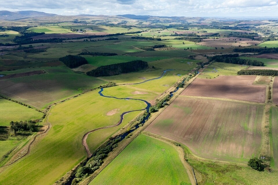
Anglian river basin district
Example 2. East Anglia river restoration and chalk stream improvements
Project location
Various locations across East Anglia.
Partners
Various.
Funding
- Water Environment Improvement Fund (WEIF)
- Chalk Partnership Fund
Project description
Through WEIF and Chalk Stream Programme funds, the Environment Agency supports partnership projects improving the water environment and creating better places for people and wildlife. The CaBA is at the heart of this programme, maximising environmental outcomes and innovation.
The Environment Agency Catchment Delivery teams help collaborate with CaBA catchment partnerships, developing and shaping projects to delivery. Partners connect people, strengthen collaboration, tackle challenges together and deliver vital multi-benefit projects to shared local priorities:
- promoting holistic catchment management to improve connectivity in the region – safeguarding chalk streams and aquifers from source to sea
- restoring and protecting East Anglia’s precious fenland and broadland habitats
- improving soil health and reducing pollutant loss through rural land management using a natural capital approach
- integrating NFM with Water Framework Directive (WFD) objectives to deliver multiple benefits in areas at risk
- using integrated wetlands to treat and enhance water quality and biodiversity
- halting the invasion of aquatic invasive non-native species (INNS)
Outputs and outcomes
Creating new wetland, peatland, and woodland habitats, restoring in-channel and bankside features and fish passage improvements. In 2024, over 91km of river has been enhanced and 192km protected.
Over 40 agricultural businesses received advice, 61 partners and 26 community groups are actively involved.
An impressive 1,102 volunteer days were dedicated to delivering these projects. The greatest benefits include increased amenity value and recreational opportunities, significant improvements in water quality, biodiversity, and carbon sequestration.
Links
River restoration improves habitats in East Anglia
2023-24 Tales from an East Anglian Riverbank

Bure Riverlands project. Credit: Geoffrey Morley, National Trust.

Stour national landscape new wetland features. Credit: Adam Lunn, Environment Agency Drone Team.

New NFM pond. Credit: Andrew Morsley, River Thame Conservation Trust.

Pant valley pilot - new pond. Credit: Matt Butcher, Environment Agency Environment Programme.
Example 3. Belton floodplain reconnection partnership project, part of the Witham, Slea Blue Green Corridor project
Project location
Environment Agency Lincolnshire and Northants Area, Witham catchment.
Partners
- South Kesteven District Council (lead partner)
- North Kesteven District Council
- National Trust
- Environment Agency
Funding
- Environment Agency Fisheries Improvement Fund
- FCERM
- local authority
- National Trust
- European Development Regional Fund
Project description
Wetted lowland floodplains are important and rare habitats that provide many ecosystem benefits. Restoring these can require moving large amounts of soil, which can be costly. This is an innovative and sustainable example using less expensive, less intensive and more natural methods. Building on 2 successful restoration projects with the National Trust, wider partners and the Environment Agency. Delivering river channel narrowing, gravel riffles, floodplain connectivity and complexity, wetlands and restoring natural processes. It’s driven by protecting people and property, improving soil health and rural diffuse pollution, habitat restoration or creation and carbon sequestration.
To help the river connect with its floodplain and slow flows, wood jams were installed using willow and alder, and certain areas of the floodplain lowered. Floodplain complexity was increased by adding fallen wood and planting trees. Some willows were hinged in the river, on the floodplain, and shallow scrapes dug to create standing water. Structures imitating beaver dams were built to form deeper wetlands.
Outputs and outcomes
1.6 hectares floodplain wetted more frequently, 1 large permanently wet scrape, restored lowland floodplain, water storage and sediment capture. 400m channel improved 30 trees planted and 2 imitation beaver dams installed.
Improved recreation for visitors and local fly-fishing clubs.
Benefits to native crayfish and brown trout.
Link
Belton floodplain inundating with water and helping to slow the flow. Credit: David Hutchinson, Environment Agency Environment Programme.
Humber river basin district
Example 4. Moors for the Future – Sphagnum and moorland plants planting, gully blocking and monitoring
Project location
Peak District and South Pennine Moors.
Partners
- Peak District National Park Authority – Moors for Future Team (lead)
- Environment Agency
- Natural England
- National Trust
- RSPB
- Severn Trent Water
- United Utilities
- Yorkshire Water
- Pennine Prospects
- representatives of the moorland owner and farming community
Funding
- water companies
- EU Life
- National Lottery
- FCERM
- Water Environment Improvement Fund (WEIF)
Project description
An inspirational and successful example of moorland restoration. This partnership aims to secure long-term sustainability of upland peatlands, critical for flood mitigation, water quality, carbon storage, biodiversity, and rural economies. It’s one of the Humber river basin district local measures in the 2022 RBMPs, supporting improvements to ecology and multiple benefits. Since 2003 the Moors for the Future partnership has developed and delivered a landscape scale programme of blanket bog restoration. Partners have invested over £50 million to conserving and repairing moors in the Peak District and South Pennines.
Outputs and outcomes
Using innovative conservation techniques, it’s transformed over 35km2 of black degraded peat in the Peak District National Park, South Pennine Moors Special Area of Conservation (SAC) and West Pennine Moors SSSI, including:
- a monitoring programme to provide evidence on effectiveness of techniques
- evolving communications, aiming to inspire people to care for these special places
- repairing damage caused by industrial pollution and habitats change
- millions of pounds of value to the public from improved landscape, plants and wildlife, water quality, flood prevention and carbon storage
Link
Bleaklow before moorland restoration. Credit: Moors for the Future Partnership.
Bleaklow after moorland restoration. Credit: Moors for the Future Partnership.
Example 5. Yorkshire Regional Flood and Coastal Committee NFM and working with natural processes
Project location
Environment Agency Area Yorkshire, Humber River Basin
Partners
- Yorkshire Flood and Coastal Committee (YFCC)
- Leeds City Council
- Integrated Catchment Solutions Programme (iCASP)
Funding
- RFCC local levy
- partnership contributions
Project description
Yorkshire RFCC are developing a strategic programme approach to NFM, investing £800,000 local levy funding. It’s ran by the Yorkshire RFCC Environment subgroup, so the Yorkshire regions approach to flood risk is delivered in a way that achieves wider environmental benefits like water quality and ecology. The Yorkshire RFCC Environment subgroup shares regional evidence, learning and practice including taking part in the National RFCC Conservation members network, supports the iCASP partnership and its NFM community of practice (CoP) and funds projects on the ground.
Outputs and outcomes
ICASP NFM CoP upskills practitioners in Yorkshire and wider. This enables more efficient and targeted projects delivering outcomes for flood risk and natural environment.
The NFM CoP has a resources page on the iCASP website with different topics like techniques, monitoring and finance.
The NFM CoP partners also wrote the CIRIA NFM manual that has national examples.
The Yorkshire RFCC subgroup continue to align flood risk activities and improve water quality and ecology.
Links
Yorkshire Regional Flood and Coastal Committee
iCASP NFM: Community of Practice
Example 6. Calder Greening
Project location
Aire and Calder catchment, Environment Agency Area Yorkshire, Humber river basin district.
Partners
- Calderdale Council
- Yorkshire Wildlife Trust
- Environment Agency
Funding
Total project value £1.17 million – £1 million partnership funding including £600,000 European Development Regional Fund.
Project description
Between 2019 to June 2023 this partnership compliments and enhances flood alleviation schemes (FAS) like the Caldene Bridge project (Mytholmroyd FAS). The Yorkshire Wildlife Trust project focussed on an area of 110 hectares providing multiple benefits for people, the local economy, and wildlife along the river Calder and tributaries. It established a resilient blue green corridor, improving water quality, habitats, biodiversity, flood plain connectivity, land management and INNS control.
One of the last projects delivered a 4.5 hectare wetland nature reserve is on an 8 hectare area of floodplain downstream of Mytholmroyd. This provides access to attractive outdoor spaces for the local community. There is a feeling of more investment in the local natural environment, a more positive relationship with the river catchment and increased community involvement and resilience. Instances of INNS have been reduced.
Outputs and outcomes
9 hectares river habitat created or improved.
4.5 hectares new wetland, 400 trees planted.
13km of bankside features created or restored.
1.6km new recreational access routes.
5 community groups involved.
Links
Calder Catchment Partnership – Catchment Data Explorer
Innovative new nature reserve brings environmental benefits – Calderdale Council

Brearley Fields wetland nature reserve from a drone shot. Credit: Calderdale Council report site management plan.
Brearley Fields wetland nature reserve - group from the partnership. Credit: Calderdale Council report site management plan.
Example 7. SUNRISE Project – Stoke and Urban Newcastle Rediscovering Its Secret Environment
Project location
River Trent at the Victoria Ground and Staffordshire University, Humber river basin district
Partners
- City of Stoke-on-Trent Council
- Newcastle-under-Lyme Borough Council
- Staffordshire Wildlife Trust
- Groundwork West Midlands
- Wild Trout Trust
Funding
- WEIF
- European Regional Development Fund (ERDF)
Project description
The Trent rises outside the city of Stoke-on-Trent. Historically it was straightened resulting in degraded habitat. Through the ERDF funded SUNRISE Programme 2 of the most degraded sections (Victoria Ground and Staffordshire University) were restored creating a more natural river channel and removing the last significant barrier to fish migration in this catchment. Restoring the river helps achieve WFD aims by creating improved habitat for fish, insects and natural processes to enable the river to self-cleanse and mitigate urban diffuse pollution. This project directly improves 1km of river channel, and removing the weir at Victoria Ground opened up 10km of improved fish passage to the Trent headwaters.
Outputs and outcomes
25km enhanced river and brook corridor habitats.
130 hectares habitats improved.
1.5 hectares new floodplain created.
WFD elements improved.
Significant barrier to fish passage removed. More resilient river ecology to effects of urban diffuse pollution. Improved habitats for fish and insects.
Communities better connected to their local green spaces.
Partnership established and future delivery planned. Reduced flood risk.
Learning
Early engagement with different teams to co-design and secure buy in.
Communication is key – establish roles and responsibilities between partners early, keep regular communication and maintain good records of meetings.
Go big – this project is a result of previous small-scale projects in the catchment with the SUNRISE partners. This built momentum and created the ambition and partnership to deliver a much bigger project.
Keep going – use momentum created to look for more opportunities to deliver.
Tell the story – this example attracted significant media interest including featuring on BBC’s Countryfile.
Links
Stoke-on-Trent and Urban Newcastle – Staffordshire Wildlife Trust
SUNRISE Project Creates an Urban Oasis – Wild Trout Trust

New river channel during construction. Credit: Environment Agency Environment Programme.
New river channel after completion. Credit: Environment Agency Environment Programme.
North West river basin district
Example 8. Aiming for high ecological status in the River Irt
Project location
Environment Agency Area Cumbria and Lancashire, North West river basin district.
Partners
- Environment Agency
- Natural England
- West Cumbria Rivers Trust
- Freshwater Biological Association
- National Trust
Funding
- Water Environment Improvement Fund
- Species Recovery Programme
- Countryside Stewardship
- Water industry investment
- European Union Life
Project description
Partnership works increasing the ability of the River Irt and its tributaries to show natural processes. Sustainable land management is promoted by farmers, some supported by Countryside Stewardship Schemes to deliver projects.
Freshwater pearl mussels in the River Irt need high water quality standards and natural habitat function. This is critical for juvenile mussels to live. The water body objective of good ecological status was not delivering habitat of good enough quality, so the objective was changed to ‘High’ to better reflect the needs of the fresh water pearl mussels. This brings funding for restoration previously unavailable to this area.
The conservation strategy focuses on both habitat improvements and release of captively reared juvenile pearl mussels. A habitat quality map of river reaches identifies the areas of greatest physical modification and restoration need.
Pressures addressed include physical modification, pollution from rural areas, INNS, sediment, changes to water levels and flows, climate change and biodiversity crisis.
Outputs and outcomes
Works are tailored to each location and include former channel reconnection, riparian fencing and tree planting.
Careful large wood and boulder introduction, deculverting, revetment removal and natural bank stabilisation.
INNS control is also carried out including Himalayan balsam, American skunk cabbage and Japanese knotweed.
Learning
Bringing different partners together maintains momentum. Provide advice when it’s needed and keep the project focused on its goals. Draw on technical expertise in different teams to drive innovation, such as creating a habitat quality index for riverine units in this catchment helped prioritise delivery. The next steps include innovative funding, such as blending government and private funding with Countryside Stewardship, to deliver larger river restoration projects farmers previously found hard to fund.
Link
River Irt — West Cumbria Rivers Trust
River Irt, Black Wood before wood revetment works. Credit: West Cumbria Rivers Trust.
River Irt, Black Wood after wood revetment works to enhance river habitat. Credit: West Cumbria Rivers Trust.
Example 9. Upper Weaver Catchment – Water Friendly Farming
Project location
Weaver catchment, Environment Agency Area Greater Manchester, Mersey and Cheshire Area, North West river basin district.
Partners
- Mersey Rivers Trust
- farmers and landowners
- Severn Rivers Trust
- United Utilities
- Bentley Environmental Foundation
- Environment Agency
Funding
- Water Environment Grant
- Water Environment Improvement Fund
- Better Rivers Better North West Fund
- Bentley Environmental Foundation Fund
Project description
6 years and 6 projects, Mersey Rivers Trust work in partnership supporting farmers improving water quality and developing sustainable farm management. This area was chosen due to moderate to poor WFD status. Farms were given free advice, creating water management plans and awarded small grants to implement improvement actions.
Outputs and outcomes
115 water management plans written, 66 farms committed to works with funded interventions and over £230,000 of funding provided to farms.
115 farmers engaged at Pie and Pint evenings.
409 metres of guttering on farm buildings: to separate clean and dirty water and reduce foul drainage runoff.
562 metres of yard and gateway resurfacing: to prevent erosion and reduce the risk of water pollution from surface runoff.
2,491 metres of fencing: to prevent livestock entering water courses, reducing erosion of banks and soil runoff.
2 livestock crossing points improved: to reduce poaching and reduce risk of water pollution from surface runoff.
1 water trough, 2 pasture pumps installed: for livestock drinking alternatives to the watercourse to reduce bank erosion and faecal water pollution.
1 bund installed: reducing surface water runoff and contamination.
Link
Mersey Rivers Trust – Water Friendly Farming
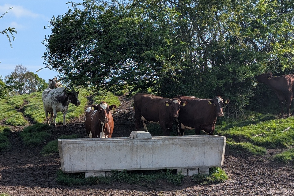
Cows drinking from raised water trough in Englesea Brook Catchment. Credit: Amara Coombes, Mersey Rivers Trust.
Rainwater harvesting tank installed alongside farm building in Valley Brook Catchment. Credit: Sally Potts, Mersey Rivers Trust.
Fencing around pond to prevent cattle entering in Ash Brook Catchment. Credit: Sally Potts, Mersey Rivers Trust.
South East river basin district
Example 10. Solent: Beneficial Use of Dredgings (BUDs) – Boiler Marsh Saltmarsh Restoration
Project location
Boiler Marsh, the mouth of the Lymington River, Solent.
Partners
- Lymington Harbour Commissioners
- Land & Water Services
- Environment Agency
Funding
- the Crown Estate (primary funder in 2025)
- Environment Agency (planning and survey work)
Project description
A pioneering saltmarsh restoration trial in the Solent uses dredged sediment for ecological and ecosystem services enhancements. With proof of this concept now confirmed, Boiler Marsh is becoming a flagship for climate-resilient coastal habitat recovery in the UK. Boiler Marsh is a 10-year restoration programme to recover lost saltmarsh habitat through sediment recharge.
After a 50% decline in Solent saltmarshes, this project trials innovative use of dredged sediment to raise marsh levels and improve ecological resilience. Phase 2 in 2025 builds on the successful 2024 deployment of 800 m3 of sediment using the bespoke ‘Saltmarsh Restoration Drag Box’ technology.
Outputs and outcomes
Proof of concept confirmed for beneficial use of dredgings.
0.5 ha restored saltmarsh planned by Autumn 2025.
Long-term goal: restore up to 10 hectares by 2035. Enhanced coastal protection, biodiversity and climate resilience.
Learning
Innovative technology can overcome logistical and environmental challenges.
Strong partnerships and adaptive planning are key to success.
Early trials are essential to refine techniques before scaling up.
Link
Restoring Meadow, Marsh and Reef (ReMeMaRe) – Estuarine & Coastal Sciences Association
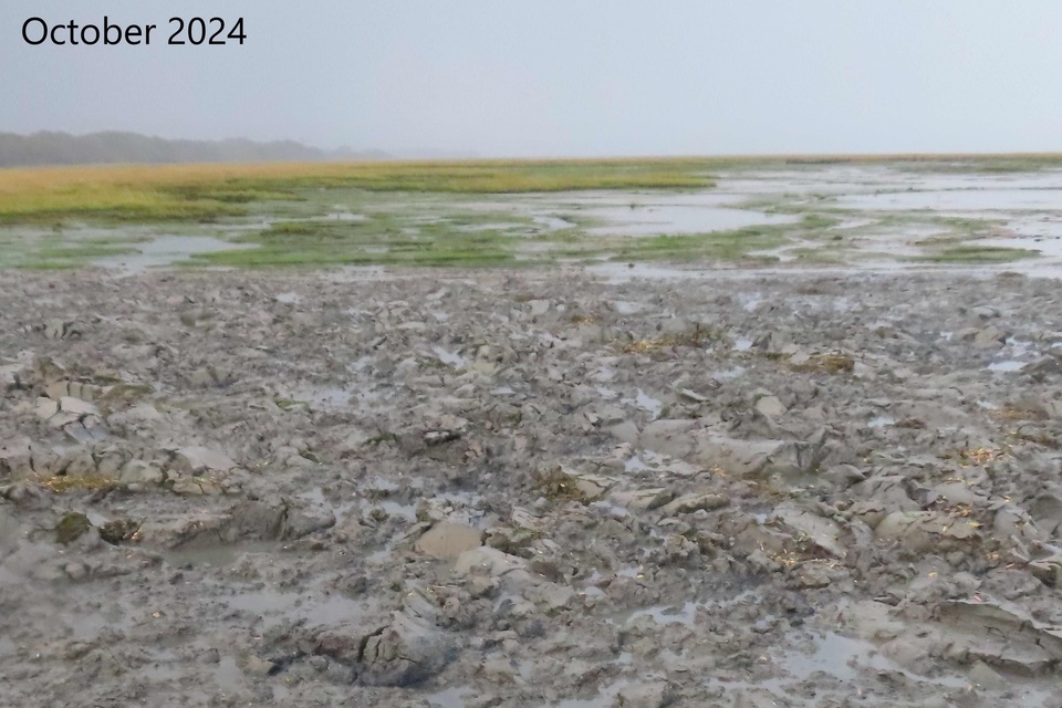
Sediment dredged from Lymington Harbour placed on Boiler Marsh, Lymington in October 2024. Credit: ABPmer.
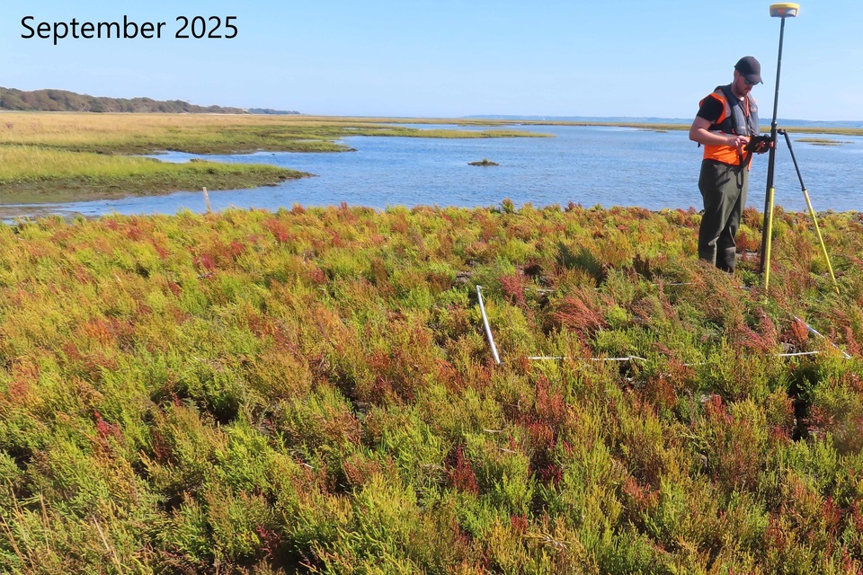
Boiler Marsh, Lymington in September 2025 showing annual samphire and sea bite. Credit: ABPmer.
Example 11. The Living Coast UNESCO Biosphere: The Aquifer Project (TAP)
Project location
Wild Park Rainscape, Moulsecoomb, Brighton.
Partners
Delivered by Brighton and Hove City Council Flood Risk Team.
Funding
- National Highways and The Aquifer Projects partners (Environment Agency, Southern Water, South Downs National Park and Brighton and Hove City Council)
- Environment Agency funding from Water Environment Improvement Fund (WEIF)
Project description
Rainscapes, or SuDS, are nature-based solutions to promote water health and climate resilience. As a partner organisation of The Aquifer Project, the Environment Agency contributed to a rainscape at Wild Park in Brighton.
The rainscape treats water running off a 2.5-mile stretch of the A27. Previously this runoff went straight into the ground through a soakaway to the chalk aquifer in a Source Protection Zone 1 – an area immediately around an abstraction point for domestic water supply or for food production.
Runoff will flow along a 1.2-mile route, passing through multiple stages of filtration before being released into the ground. 2 vortex separators have been installed in a balancing pond near the motorway to remove particles.
This project is supported by University of Brighton research. They showed a major part of the contaminant load is from the solids, so removing these is around 80% of the treatment needed. The remaining water moves through 3 bays of reeds and planting before being piped to settlement basins in Wild Park.
The next photo shows how this nature-based solution works. The first sample on the left is after recent rainfall and initial water quality at the inlet to the rainscape system. Moving right across the photo through technical separators and plant-based filtration. The final sample is where water soaks into the aquifer.
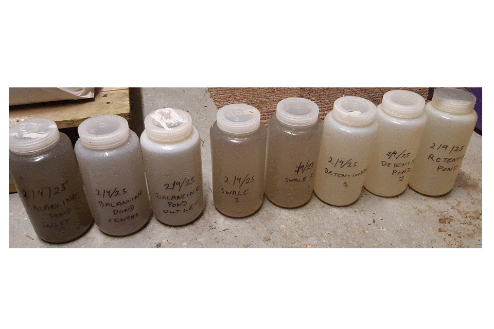
Water samples from Wild Park in Brighton. Credit: University of Brighton.
Outputs and outcomes
Improved groundwater quality to a Source Protection Zone by treating road runoff entering the aquifer.
Research on effectiveness of SuDS and rainscapes.
Amenity value to Wild Park Nature Reserve benefitting the community.
Learning
Community engagement can enhance a project. Strong partnerships help maintain momentum and funding opportunities.
Planning permission requirements need to be considered when assessing project risks at an early design stage.
Links
‘You could drink from that pond’: the city digging for a solution to toxic runoff, The Guardian

Wild Park Rainscapes, Brighton. Credit: Brighton and Hove County Council.
South West river basin district
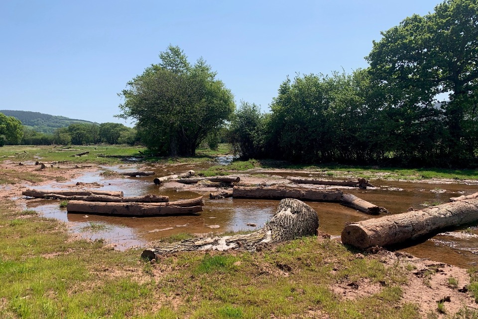
Example 12. Dartmoor headwaters NFM
Project location
Mardle and Dean Burn, Hanger Down, Colley Brook and Black Brook.
Partners
Dartmoor National Park Authority, the Environment Agency and Devon County Council.
Funding
A pilot as part of the Defra and Environment Agency £15 million NFM programme
Project description
Dartmoor Headwaters NFM project is delivering initiatives on the Mardle and Dean Burn, Hanger Down, Colley Brook and Black Brook. This partnership influences activities like livestock grazing to improve soil health and reduce soil compaction. It has supported a PhD with Plymouth University to understand impacts of planting woodland on upland areas on flooding, producing a film ‘Farming the Flood’ showcasing farmers using nature-based solutions to combat flooding.
Outputs and outcomes
River restoration and floodplain reconnection – 350 timber, stone and willow leaky dams.
Planted 6,000 trees to increase infiltration and reduce surface water runoff.
Funded 75 hectares of peatland restoration.
Link
Dartmoor Headwaters Natural Flood Management Project

NFM wood dam at Brook Manor. Credit: Phil Metcalfe, Environment Agency.
Example 13. Holnicote – Portlock Vale Stream Riverlands project (PVSR)
Project location
Holnicote Estate, West Somerset, Environment Agency Wessex Area, South West river basin district. A 12,500-acre site within Exmoor National Park, encompassing the Horner Water and River Aller catchments, part of Hawkcombe Stream, Porlock Saltmarsh, upland woodland, and lowland farmland.
Partners
- National Trust (lead partner)
- Environment Agency (funding and technical support)
- Exeter and Nottingham Universities (research and monitoring)
Funding
£3.5 million total investment by 2025 to 2026, Major contributions:
- Interreg Source 2 Sea
- Green Recovery Challenge Fund
- National Trust
- Environment Agency £500,000 (15% match funding, £6 leveraged for every £1 invested)
Project description
Launched in 2018 as a Riverlands Programme pilot, the PVSR Project aims to restore natural river processes, improve ecological function, and create a mosaic of high-quality habitats across the Holnicote Estate. With 2 entire catchments under single ownership, this site offers a rare opportunity for landscape-scale restoration. This project pioneers Stage 0 river restoration, rewilded floodplains, reintroduced species, and integrated nature-based solutions to tackle pollution, flooding, and climate resilience. By the end of 2025 to 2026 the first phase of the PVSR project will be completed but this project is due to continue through the Holnicote Rivers Landscape Recovery project and the next phase of the Riverlands Programme.
The Holnicote River Corridors Landscape Recovery Project goes beyond the boundary of the Holnicote Estate, working with neighbouring landowners like Porlock Manor Estate and Exmoor National Park Authority. The Landscape Recovery Project seeks to create wide and wild river corridors across the entirety of the Aller and Horner catchments, and upper Hawkcombe Stream. It includes changing land management practices across large parts of the landscape to develop and improve new and existing habitats. The aim is to prepare the landscape for a wild beaver release to enable a long-term, sustainable and cost-effective way of improving and managing water habitats by working with nature.
Outputs and outcomes
95,000 trees planted, 2km hedgerow, 25 hectares of natural regeneration.
3 major Stage 0 floodplain reconnection schemes – River Aller, Tivington Farm, Mudpool Meadow.
Upland peat restoration at Hurdledown.
10+ pond complexes, 5km of NFM interventions, 2 beaver enclosures established, water vole reintroduction. INNS control across the estate.
Monitoring includes 2 PhDs and contributes to national nature-based solutions database.
River Aller restoration: 38% flood peak reduction, 1780% groundwater increase, 8 hectares wetland habitat created.
Learning
Stage 0 restoration is transformative for habitat quality and hydrology.
Beavers are powerful ecosystem engineers with measurable benefits.
Long-term partnerships and diverse funding streams are key to success.
Monitoring and adaptive management are essential for scaling up nature-based solutions. Holnicote’s integrated approach is a model for future Environment Land Management Schemes Landscape Recovery initiatives.
Links
National Trust Holnicote 2025 River Prize award press release
Holnicote case study – River Restoration Centre
Watch a short video about the project produced for the 2025 UK River Prize
Floodplain restoration, Holnicote Estate. Image credit: National Trust
Severn river basin district
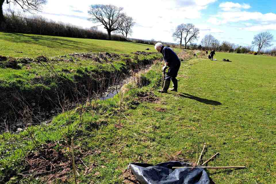
Example 14. Severn Upper Marches River (SUMR) Project
Project location
Rea Brook Catchment, Severn uplands, Environment Agency West Midlands Area, Severn river basin district.
Partners
- Severn Uplands Catchment Partnership
- Severn Rivers Trust
- landowners
- Reaseheath College
Funding
- Water Environment Improvement Fund
- landowner contributions
- Lead Local Flood Authority Funding
- Water Environment Grant
Project description
This is a whole catchment, multi partner and multi beneficial approach aims to compliment and build on the success of the 3-year Reaction project. The waterbodies in the SUMR project area did not meet the required good ecological status under the WFD, mainly due to diffuse pollution from agricultural sources and modified physical habitat impacting on invertebrate and fish species. Many small villages across the catchment have suffered recent flooding.
Outputs and outcomes
4km of enhanced and improved river and brook corridor, 3 hectares of improved habitats, improved habitat for fish and invertebrates.
Improved water quality and WFD elements. Barrier to fish passage removed.
Reduced flood risk. Communities better connected to their local green spaces.
Learning
Involve landowners in the project design, planning and delivery. This really helps increase buy in from the farming community. A trusted farm adviser is vitally important to the success of any project. Projects need long term investment in the catchment to build momentum and ensure effective engagement with landowners.
There are lots of different organisations working in the catchment and many funding opportunities out there. Good communications is key to creating a sum greater than the parts and us complementary funding streams to maximise the environmental benefits.
Link
Rea Brook Natural Flood Management Demonstrator

Completed riparian wetland in Rea Brook catchment. Credit: Guy Pluckwell, Environment Agency Environment Programme.
Solway Tweed river basin district
Example 15. Waver Wampool Farming Futures Project
Project location
Waver Wampool Catchment, Northwest Cumbria.
Partners
- West Cumbria Rivers Trust
- farmers and landowners
Funding
- Waste and Resources Action Programme (WRAP)
- Environment Agency Water Environment Improvement Fund (WEIF)
- Farming in Protected Landscapes (FIPL) for land in the Solway National Landscape
- contributions from the food supply sector
Project description
This project, led by West Cumbria Rivers Trust (WCRT) in partnership with local farmers, aims to support sustainable practices that protect soil, improve water quality and help future proof farming businesses. This is one of 10 collective action projects globally (5 in the UK) which are delivering on the UK Food and Drink Pact which aims to achieve sustainable water management in the most at-risk UK and global sourcing areas and ensure 50% of fresh food is sources from areas with sustainable water management.
Outputs and outcomes
This project has been underway for just over a year.
Farmer events, farm advice, and capital delivery. Ambitious pipeline of farm advice work planned for 2025 to 2026, involving water management plans for 5 farms and nutrient management plans for a further 23 farms.
Farmer events delivered in 2025 included rainwater harvesting, soil management to improve nutrient use efficiency and managing herbal leys with rotational grazing. WEIF funding will deliver 2.2km of riparian strip, 0.98ha of improved habitat and 500 trees in the winter of 2025 to 2026.
WRAP NB funding is being sought to deliver wetlands, biofilters and rainwater harvesting systems on eleven sites (11 rainwater harvesting systems and 6 wetlands).
Monitoring and reporting strategy to track progress against its objectives.
Learning
Opportunities to learn from the other WRAP-funded collective action projects in the UK and globally. This project draws expertise from the Environment Agency’s Future Farming and Soils teams, National Farmers Union, Agriculture and Horticulture Development Board and Natural England Catchment Sensitive Farming. This partnership identifies key research, particularly farmer perceptions and behaviours.
WCRT staff are involved in an Environment Agency, Catchment Sensitive Farming and UK Centre for Ecology and Hydrology project to evaluate impacts of ammonia mitigation on sensitive habitats, with new opportunities to engage farmers in the catchment.
Links
Rivers Waver & Wampool — West Cumbria Rivers Trust
UK Food and Drink Pact: the Water Roadmap – WRAP – The Waste and Resources Action Programme
Waver-Wampool Operational Catchment – Catchment Data Explorer
Croft House tree planting. Credit: West Cumbria Rivers Trust.
Waver Bank after tree planting. Credit: West Cumbria Rivers Trust.
Thames river basin district
Example 16. Thames Regional Flood and Coastal Committee NFM programme
Project location
Thames river basin district, Environment Agency London Area.
Partners
- Thames RFCC
- lead local flood authorities (LLFAs)
- CaBA
- flood action groups
- Environment Agency
Funding
- £1.4 million of Thames RFCC Local Levy funding allocated in 2021-2, with an increase to £2.6 million granted in 2024
- £1.3 million partnership contributions across all 24 projects
Project description
Collaborating on a programme of NFM to 2027. Using RBMP and FRMP consultation feedback, exploring Thames catchment-based approach, packaging measures and innovative funding to achieve more investible propositions, nature-based solutions, social and natural capital benefits through NFM and SUDs.
Outputs and outcomes
Creating NFM Opportunity and Priority Mapping helps inform catchment-wide planning for investment in NFM across the Thames catchment.
Independent NFM advisor hosted by Wildfowl and Wetlands Trust. The NFM Advisor provides expertise and support to external partners for delivery of the NFM programme.
May 2025 – one-month NFM Festival to share knowledge and build relationships with external stakeholders, CaBA catchment partnerships, local authorities, community groups.
Funding allocated to 21 small scale NFM projects up to £50,000, 12 of these have completed delivery. Funding allocated to 3 large scale NFM projects up to £200,000 for cumulative interventions across a catchment. Attraction of £1,327,563 in partnership funding for the NFM projects.
Learning
Simplified application process increased appetite for NFM delivery across LLFAs.
Collaboration between multiple partners is key to ensure project success.
Funding non-Risk Management Authorities organisations could be investigated.
Links
Wildfowl and Wetlands Trust advice
2025 River Restoration Centre conference talk
Example 17. Gadebridge Park chalk river restoration
Location
Gadebridge Park, Hemel, Colne Catchment, Thames river basin district, Area: Herts and North London.
Partners
- Environment Agency lead partner
- Dacorum Borough Council landowner
- Affinity Water Limited
Funding
Total project cost £4.148 million:
- Environment Agency FCERM £2.268 million
- Environment Agency Water Resources £1.510 million
- Affinity Water £250,000
- Dacorum Borough Council £120,000
Project description
The River Gade is a globally rare chalk stream with poor ecological status in the park due to modified habitats and flow. The Gade used to flow down a ‘perched’ or raised channel, created to supply water to Bury Mill and was disconnected from its floodplain.
The river channel was made wider than it should be naturally, leading to a build-up of silt and vegetation. This partially blocked the river. Being disconnected from groundwater and spring flow had a significant impact on low flows and wildlife resilience. The weir at the Environment Agency Bury Mill Gauging Station and other in-channel structures acted as barriers to fish movement.
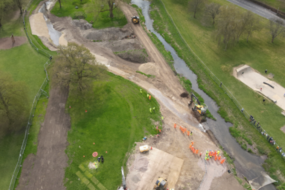
This project diverted 415 metres of river channel to the valley bottom through the park. The Bury Mill gauging station was replaced with an ultrasonic one to enable fish passage. Work progressed from 2018 with construction complete in June 2025.
Outputs and outcomes
0.85 hectares of habitat created, 3.9 hectares habitat enhanced, 6.5km of river restored, 0.9 hectares buffer strip created to provide corridors of vegetation that help improve conditions for wildlife, protect the channel from excessive erosion and slow the flow.
1.1km water body opened to fish passage, better resilience to low and high flows and impacts of climate change.
2 new bridges and a large gravel access point to the channel. Collection of spring flow data and understanding of how it contributes to chalk streams.
8 community events. Enabling residents and visitors to engage in the partnership, get closer to the river and enjoy nature. Positive feedback from school visits who learnt about the importance of chalk streams.
Progress towards achieving WFD objectives, local and national biodiversity targets. Compliance with the CaBA Chalk Stream Strategy.
Learning
Factor in a good financial contingency, think about contractors available on the Environment Agency framework, increases in material costs, inflation, resource charges, and compensation events. Understanding design changes, working with the designer to estimate cost increases.
The project group has members with the required authority. Set accountabilities early to avoid delays and misunderstanding and clarify each team’s role. Technical team leads own elements of the project to ensure all discussion items are logged and addressed. Close working relationship with designer and the technical teams. Ensure staff have the training and capabilities to do their role in the project team and available resource.
Develop a robust benefits realisation strategy early on to enable a better understanding of the benefits to all parties and a greater financial contribution.
Walk the line of works with the Topography Plan and Tree Survey before starting works at site, to check for mapping discrepancies
Engage local community in a variety of ways such as a project web page, mailing list updates, project mailbox, Facebook, Twitter, council newsletters, onsite signage, community events.
Links
Gadebridge Park river restoration information page – Environment Agency – Citizen Space
River Gade restoration in Gadebridge Park nears final phase
River Gade perched mill leat. Credit: Environment Agency Environment Programme.
Flow diversion to new channel April 2025. Credit: Environment Agency Environment Management.
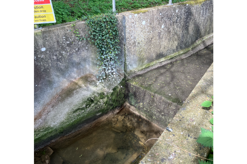
Bury Mill gauging station before the project. Credit: Environment Agency Herts and North London.
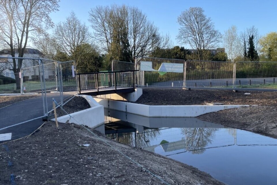
New ultrasonic gauging station. Credit: Environment Agency Herts and North London.
Solway Tweed river basin district
Example 18. LIFE Water and Disturbance Environmental Restoration (WADER) – Harehope Estate
Project location
River Breamish, Old Bewick near Wooler, Northumberland.
Partners
- Environment Agency
- Tweed Forum
- Harehope Estate
- Natural England
- Newcastle University
Funding
- Environment Agency
- EU LIFE Programme LIFE2/NAT/UK/000277 – ‘LIFE WADER’
Project description
The River Breamish is part of ‘The River Tweed’ SAC designated for the site’s importance to fish, mammal and plant species. This project implements habitat restoration measures on 3km of the most straightened, modified channel in this catchment. It contributes to the WFD protected area objective of restoring the extent and pattern of in-channel and riparian habitats to characteristics of natural fluvial processes.
Initial feasibility work commissioned by Tweed Forum from CBEC was developed by the Environment Agency who led design and construction works with AECOM and Ebsford. This project aimed to test the question if river restoration improves water quality specifically nutrient loadings by allowing more fine sediment to settle on the floodplain, improving bio-geochemical function, stream metabolism and stream ecosystem productivity. Promoting the development of complex riparian buffers, will help adapt to climate change and the predicted increase and frequency of high flows.
Outputs and outcomes
1.6km of flood banks permanently breached and removed making space for water.
1.5km of river restored to a re-meandering unconstrained gravel riverbed.
20 hectares of floodplain re-connected to river.
1.5 hectares of priority habitat created.
3 hectares of native woodland created.
SAC river habitat improved towards unfavourable recovering status objective.
Longer-term maintenance is linked to a 20 year ‘Making Space for Water’ Environmental Land Management Scheme agreement with landowners, Natural England and the Rural Payments Agency. The effects of river restoration will be monitored, alongside impacts on the wider catchment in the Breamish, River Tweed, Special Areas of Conservation (SACs) and Special Protection Areas (SPAs).
Links
LIFE WADER: project information note 1
River Breamish restoration, Harehope Estate 2025. Credit: DW Agency.
Northumbria river basin district
Example 19. Tees Tidelands partnership
Project location
Tees Estuary, Teesside.
Partners
- Stockton-on-Tees Borough Council
- Tees Rivers Trust
- National Highways
- Northumbrian Water Limited
- The Greatham Foundation
- Tees Valley Wildlife Trust
- Environment Agency
Funding
- Environment Agency
- Stockton-on-Tees Borough Council
- National Highways
- Northumbrian Water Limited
Project description
The Tees estuary is one of the most heavily physically modified habitats in the country. Around 90% of floodplain habitats were filled in and damaged for port and industrial development using waste from the iron and steel industry, and with coastal defences and tidal barriers on all major tributaries.
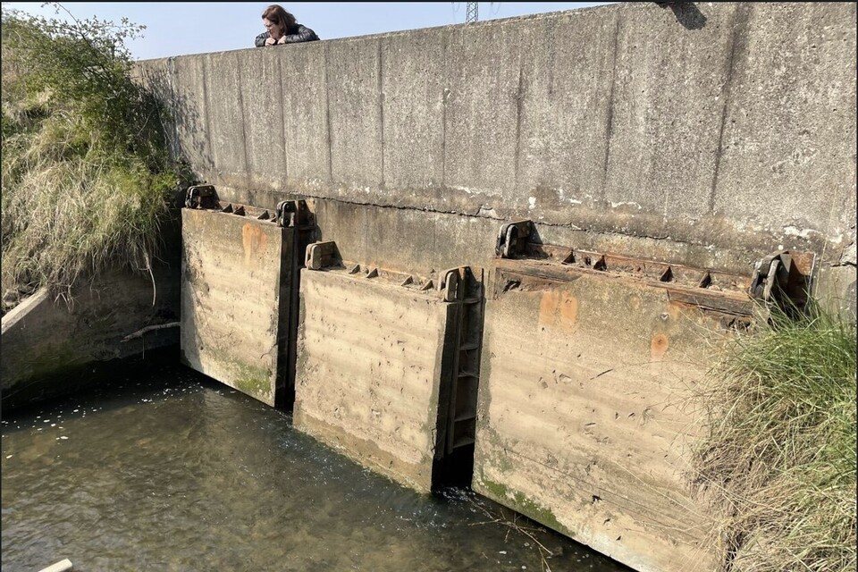
Tees Tidelands aims to realign flood defences, restore intertidal and river habitats, reconnect tributaries and communities to the estuary. This contributes to achieving the WFD protected area objectives for the Teesmouth and Cleveland Coast SPA. Barriers on Billingham Beck and Ormesby Beck have been removed and floodplain connectivity restored with no impact on flood risk. Greatham Beck tidal sluice will be removed by April 2026, restoring tidal connection, river and saltmarsh habitats.
Proposals are developing to restore tidal influence in the lower reaches of the Lustrum Beck and Portrack Marsh. A project to realign coastal defences at Greatham North East will restore intertidal mudflat expanding the internationally important Seal Sands. Tees Tidelands works with partners like the Tees Rivers Trust reintroducing seagrass and oysters, the Canal & River Trust working to improve fish passage across the Tees Barrage, and the Tees Estuary Nature Recovery Partnership.
Outputs and outcomes
55km of river opened to fish passage.
21 hectares of intertidal saltmarsh habitat restored.
14 hectares of water dependent floodplain habitat re-connected to river.
10 hectares of other habitats enhanced.
SPA habitat improved towards favourable status.
Learning
Permissions needed to restore nature in estuaries requires significant resource and time to secure.
Link
Tees programme launched to reduce flood risk and boost nature
Greatham Beck tidal sluice that currently prevents tidal waters moving upstream. Credit: Environment Agency.