National overview (part a)
Published 12 December 2022
Applies to England

© Crown copyright 2022
This publication is licensed under the terms of the Open Government Licence v3.0 except where otherwise stated. To view this licence, visit nationalarchives.gov.uk/doc/open-government-licence/version/3 or write to the Information Policy Team, The National Archives, Kew, London TW9 4DU, or email: psi@nationalarchives.gov.uk.
Where we have identified any third party copyright information you will need to obtain permission from the copyright holders concerned.
This publication is available at https://www.gov.uk/government/publications/flood-risk-management-plans-2021-to-2027-national-overview-part-a/national-overview-part-a
Foreword
At least one in six people in England are at risk from flooding from rivers and the sea with many more at risk from surface water flooding. With a rapidly changing climate, adapting what we do and improving our overall resilience is more important than ever before.
Partnerships and collaboration are vital. The more we work and plan together, the more we can achieve for local people, places and our environment.
Over the last 3 years we have worked in partnership with lead local flood authorities and other partners to develop these flood risk management plans (FRMPs). This has been a challenging time with winter flooding and the impact of coronavirus. These tests have reinforced how precious the environment around us is for our health and well-being, and the importance of protecting and enhancing it.
The FRMPs mark an important contribution towards helping to deliver the ambitions of the ‘national flood and coastal erosion risk management strategy for England’ and the government’s 25 year environment plan. They focus on the more significant areas of flooding and describe the risk of flooding now and in the future.
These plans will help us:
-
identify measures (actions) that will reduce the likelihood and consequences of flooding
-
to improve resilience, which is the capacity of people and places to plan for, better protect, respond to, and to recover from flooding and coastal change, while informing the delivery of existing flood programmes
-
work in partnership to deliver wider resilience measures. These include nature based solutions, property flood resilience and sustainable drainage systems
-
plan and adapt to a changing climate through developing longer-term, adaptive approaches
In many cases the measures (actions) in the plans help contribute to wider benefits for local places including climate mitigation and adaptation, nature recovery as well as integrated water management.
We’ve developed the flood plan explorer to support these plans. This means we can stimulate even more opportunities for working together and co-operation across all we do.
We’ve listened to what you told us during the consultation that we carried out in October 2021 and we value what you value too. The importance of partnerships to deliver actions, the need to strengthen a catchment approach so we work with and better recognise the value of the natural environment, and the places we live and work in. In addition, we need to rise to the challenge of making infrastructure resilient to flooding while reducing carbon use.
The Environment Agency knows the next 5 years will be both exciting and challenging. We need to innovate and adapt, making sure our thinking and actions change faster than our climate. The flood and coastal erosion risk management strategy roadmap to 2026 (strategy roadmap) will help us do that by providing practical ways in which flood and coastal investments can contribute to wider priorities including local nature recovery, carbon reduction and more integrated water solutions that also help with drought resilience.
I’m pleased we have this opportunity to share the final FRMPs an important milestone but not the end. We cannot do any of this alone and you’ve told us you want to get involved – please do. We must continue to work in partnership and keep putting communities at the centre of what we do so they can adapt and thrive.
Caroline Douglass, Executive Director of Flood and Coastal Risk Management Environment Agency.
Introduction
This ‘part a’ document provides a high-level overview of flood risk management plans (FRMPs) and flood risk management in England. It’s relevant to all 10 of the individual FRMPs and should be read alongside them.
It includes information on:
-
the context of FRMPs in strategic flood risk management planning
-
the legislative background to FRMPs and why we produce them
-
flood risk management at a national level
You can find more detailed information about some of the topics in this document by following the links.
Strategic flood risk management planning
Strategic flood risk management planning plays an essential role in informing the choices made to manage flood risk.
At a national level this is set out in the national flood and coastal erosion risk management strategy for England (FCERM strategy) and locally in flood risk plans and strategies, such as FRMPs, local flood risk management strategies, drainage and wastewater management plans and shoreline management plans.
Good strategic planning can help to:
-
bolster the resilience of people and places to flooding and coastal change
-
enable people and places to anticipate future climate impacts and put plans/actions in place to adapt to increased flooding and coastal change
-
bring partners together to set the strategic direction for flood risk management and identify common priorities for places
-
inform flood risk capital investment programmes and identify interventions, including identifying opportunities for new FCERM projects
-
align wider investment plans and work programmes between partners including with infrastructure providers
-
identify innovative solutions, for example nature based solutions, integrated water management as well as developing longer term, adaptive approaches
FRMPs make an important contribution to strategic working and planning as they help partners plan locally across administrative boundaries. FRMPs are statutory plans. This means they are required by law and are guided by legislation, policy and local priorities. They provide a basis for local engagement and consultation with partners and communities.
FRMPs are also one of many important steps in achieving the ambitions of the FCERM strategy, its roadmap to 2026 and the government’s 25 year environment plan – a green future: our 25 year plan to improve the environment (25 YEP) to create a nation that is resilient, and able to adapt to, future flooding and coastal change – now and to the year 2100. They also support the direction set by government policy in the FCERM policy statement. They do this through the objectives and measures (actions) set out in the plans, providing local detail on how these strategic aims will be met in each place, and how this will be supported by actions being taken at national and local level.
National FCERM strategy and the 25 YEP
The Flood and Water Management Act 2010 places a statutory duty on the Environment Agency to develop a national flood and coastal erosion risk management (FCERM) strategy for England. This strategy describes what all risk management authorities (RMAs) involved in flood and coastal erosion risk management for the benefit of people and places need to do.
The Environment Agency published the updated national FCERM strategy in 2020. The strategy’s long-term vision is for: a nation ready for, and resilient to, flooding and coastal change – today, tomorrow and to the year 2100.
The FCERM strategy has 3 long-term ambitions.
These are:
-
climate resilient places
-
today’s growth and infrastructure resilient in tomorrow’s climate
-
a nation ready to respond and adapt to flooding and coastal change
The FCERM strategy calls for the nation to embrace a broad range of resilience actions. Alongside continuing to build and maintain flood and sea defences, we need more nature based solutions, sustainable drainage systems and property flood resilience measures. We also need to continue avoiding inappropriate development in the floodplain and making sure we are better prepared to respond to floods through timely and effective forecasting, warning and evacuation. The strategy also recognises that it is not possible to prevent all flooding, therefore where the worst sadly happens we need to help communities and local economies recover quickly and ‘build back better’. This will ensure properties and infrastructure are more resilient to future flooding.
The strategy provides a framework for guiding the operational activities and decision making of practitioners. It supports the direction set by government in its FCERM policy statement. The strategy sets out the long-term objectives the nation should take over the next 10 to 30 years. It also includes shorter-term, practical measures RMAs should take working with partners and communities.
The FCERM strategy roadmap to 2026 builds on the positive steps included in the 1-year action plan published in May 2021. It describes how the Strategy, its objectives and measures will be translated into practical action over the next 4 years, and what will be different as a result. The roadmap directly supports the implementation of the £5.2billion flood and coastal erosion risk management (FCERM) investment programme which will better protect many hundreds of thousands of properties over the next 6 years. It also incorporates the £200m flood and coastal resilience innovation programmes which will improve our evidence on the costs and benefits of innovative resilience actions as well as help inform future approaches to, and investments in, flood and coastal risk management.
Producing an updated FCERM strategy was an important commitment in the 25 year environment plan (25 YEP). The 25 YEP sets out aims for improving the environment, within a generation, and leaving it in a better state than we found it.
The plan includes goals to:
-
bring a thriving, natural environment with cleaner air and water
-
reduce harm from hazards such as floods and drought
-
improve sustainable use of natural resources
This is in the context of climate change, increasing populations and ambitious goals for economic growth and prosperity.
This challenge calls for a long-term, strategic approach to flood risk management that will reduce risk, help future growth and make sure people live in climate resilient places. The Environment Agency, other RMAs and stakeholders will need to work together in a way that respects and improves the water and wider environment.
Aim of second cycle FRMPs
The Flood Risk Regulations 2009 (FRRs) set out a statutory process for flood risk planning over a 6 year cycle. The second cycle FRMPs (2021 to 2027) are strategic, place-based plans. They include objectives and measures closely aligned to the ambitions and goals of the FCERM strategy, actions with the FCERM strategy roadmap and 25 YEP. They also aim to support achieving wider environmental and growth ambitions of society. They aim to show what’s happening to address flood risk not only in identified flood risk areas (FRAs), but across the whole river basin district. The second cycle FRMPs will encourage RMAs to work closer together to achieve the objectives and measures.
You can find more information about the FRRs and how FRAs were identified in the ‘Purpose of the FRMP’ section of this document.
Flood risk management
Flood risk management information in this section covers all sources of flooding which is relevant to all river basin districts (RBDs) and flood risk areas (FRAs).
Definition of flooding
The Flood and Water Management Act (2010) defines a flood as ‘any case where land not normally covered by water becomes covered by water’.
RMAs describe the risk of flooding by both the:
-
likelihood that a location will flood from any source
-
impact or consequence that the flooding could cause if it occurred
The purpose of managing flood risk is to mitigate any harmful impacts caused by flooding on:
-
people
-
the environment
-
buildings and infrastructure (such as roads, railways, hospitals and schools)
This could involve taking action to reduce the likelihood and/or consequences of flooding should it occur.
Flood risk information
The Environment Agency’s service to check your long term flood risk provides information on:
-
the longer-term flood risk for an area in England
-
the possible sources of flood risk
-
how to manage flood risk
This service uses computer models to assess an area’s long-term flood risk from:
-
rivers and the sea
-
surface water
-
reservoirs
The results are an indicator of an area’s flood risk. There are 4 bands of risk representing the likelihood of flooding in any given year.
The bands of risk are:
-
high risk – this means that each year an area has a chance of flooding of greater than 3.3%
-
medium risk – this means that each year an area has a chance of flooding between 1% and 3.3%
-
low risk – this means that each year an area has a chance of flooding of between 0.1% and 1%
-
very low risk – this means that each year an area has a chance of flooding of less than 0.1%
The results for flood risk from rivers or the sea consider the effect of any flood defences in the area. These defences reduce, but do not completely stop, the chance of flooding as they can be overtopped or fail.
Flooding from surface water is difficult to predict as the exact location and volume of rainfall are difficult to forecast. Local features can also greatly affect the chance and severity of flooding.
The results for reservoirs show the risk of flooding from reservoirs in the unlikely (managed to be very low risk) event of a dam failure.
National flood risk assessment
The Environment Agency is developing a new national assessment of flood risk which will provide better data and information to support local decision making, and improved ways of measuring changes in risk at a national level. It will significantly improve our understanding of flooding from surface water, rivers and the sea. It’s due to be published in 2024 and will be available as open data. This means it can be used for free by anyone.
Other sources of flooding
The Environment Agency monitors groundwater levels and provides a groundwater alert or warning service for some areas that have historically experienced groundwater flooding. The groundwater vulnerability maps for England were produced in 2013 and are available on Defra’s magic map service.
Sewer and surface water flooding resulting from wastewater networks and associated infrastructure is monitored and managed by water companies.
The Canal and River Trust are responsible for managing the level of water in canals across England and Wales for navigation purposes and to mitigate flooding. In some locations canals are managed locally by navigational authorities, the Environment Agency or other organisations.
Roles and responsibilities in flood risk management
The FCERM strategy sets out the roles and responsibilities for managing flooding and coastal change in annex a. An overview of the roles and responsibilities is below.
RMAs
RMAs are:
-
the Environment Agency
-
lead local flood authorities (county councils, unitary authorities, London boroughs and Metropolitan boroughs)
-
district councils (which may also be called borough or city councils)
-
water companies
-
internal drainage boards
-
highways authorities
The Environment Agency has a strategic overview role covering all sources of flooding and coastal change. This includes sources where other RMAs have operational responsibilities. The Environment Agency provides strategic leadership for the management of flooding and coastal change from all sources including:
-
rivers
-
the sea
-
groundwater
-
reservoirs
-
surface water
-
sewer flooding
This strategic overview role is distinct from the Environment Agency’s operational role. The Environment Agency also has permissive powers to manage flood risk from main rivers (these are usually, larger rivers and streams on the main river map), the sea and reservoirs. It can also make landowners take action to minimise flood risk to others.
As the enforcement authority for the Reservoirs Act 1975 in England, the Environment Agency has a statutory duty to manage reservoir flood risk by securing compliance. This is in addition to its permissive powers under the Reservoirs Act.
As a statutory planning consultee, the Environment Agency has an important role to play in advising planners and developers to avoid inappropriate development in flood risk areas and to enable climate resilient development. This includes identifying opportunities to protect and enhance the environment.
Lead local flood authorities (LLFAs) are the county council or unitary council. They have a leadership role on local flood risk management in their area.
This includes risks from:
-
ordinary watercourses - these are watercourses that are not part of a main river and not on the main river map outside internal drainage districts
-
surface water
-
groundwater
They have permissive powers to manage this risk and enforcement powers like the Environment Agency. LLFAs work with other RMAs to develop and maintain a strategy for local flood risk management.
LLFA’s are statutory consultees for major planning applications with surface water drainage implications, to manage run-off from new development and reduce potential localised flooding.
District councils have a role to carry out works to manage flood risk from ordinary watercourses outside internal drainage districts. They are also planning authorities and work with their LLFA to manage flood risk. District councils that are next to the sea also have the role of coast protection authorities as defined under the Coast Protection Act 1949.
Internal drainage boards are local independent public authorities established in areas of special drainage need in England.
Internal drainage boards:
-
are responsible for managing water levels within their internal drainage district
-
have powers like LLFAs and the Environment Agency
-
work with RMAs to manage local flood risk
Water companies manage:
-
the sewerage and water supply networks and any flood risk arising from them
-
flood risk to their infrastructure, such as water treatment plants and pumping stations
Highway authorities include county and unitary authorities and National Highways.
Highway authorities are RMAs responsible for:
-
providing and managing highway drainage and some roadside ditches
-
making sure that road projects do not increase flood risk
Emergency responders
Some RMAs also have a statutory role to play in planning for emergencies. These roles are classed as category 1 or 2 responders.
RMAs who also hold an emergency response role are:
Category 1:
-
Environment Agency
-
county councils
-
unitary authorities
-
district councils
Category 2:
-
water companies
-
National Highways
-
Transport for London
-
the Secretary of State for Transport
Category 1 and 2 responders come together within local resilience forums (LRFs). LRF members aim to plan and prepare for local incidents and catastrophic emergencies.
LRFs help responders work together to:
-
identify potential risks
-
produce emergency plans to either prevent or mitigate the impact of any incident on their local communities
Other organisations and people with statutory roles
Regional flood and coastal committees (RFCCs) are a mechanism for sharing information and help to achieve the best use of resources across a whole region. They are responsible for making sure there are coherent plans for identifying, communicating and managing flood and coastal erosion risks across catchments and shorelines.
They bring together individuals appointed by:
-
government
-
the Environment Agency
-
LLFAs
RFCCs have a vital assurance role to promote efficient, targeted and risk-based investment in flood and coastal erosion risk management. This role optimises value for money and benefits to local communities.
Riparian landowners are landowners who have a stretch of watercourse that runs on, under or alongside their property. They are normally responsible for that watercourse and are required to take reasonable steps to avoid causing a risk of flooding to others. Riparian landowners must also comply with any byelaws in place for watercourses on, under or alongside their land.
Large, raised reservoir owners and operators are responsible for managing the flood risk from reservoir failure, by complying with the Reservoirs Act 1975.
Ofwat is the economic regulator of the water sector. It plays a role in helping to manage flooding and secure the resilience of water supply and sewerage systems.
The Department for Environment, Food and Rural Affairs (Defra) sets the direction and policy for flooding and coastal change. It also provides funding for activities undertaken by RMAs through grant-in-aid.
Other organisations and people
Communities including flood action groups
Across the country there are many formal and informal community groups, flood action groups, partnerships and charities which have been set up to support those who have been affected by flooding and coastal change. They also help people plan for future risks.
These groups are vital in providing support, advice and practical help. They can also support RMAs by engaging in discussions or taking action to manage the risk of flooding or coastal change.
It’s important that all homeowners and renters take time to consider and understand the risk of flooding and coastal change to their property. It’s also important for them to think about the options they must adapt to and how to manage this risk. They should for example, consider incorporating property flood resilience measures or signing up for flood warnings.
Housebuilders/developers should consider the role they have in improving the resilience of people and places to flooding and coastal change. They should for example consider the role of sustainable drainage systems and property flood resilience measures in new or existing developments.
Insurers can provide help and support to those affected by flooding by providing repairs and finance. They also have an interest in promoting resilience both at community and individual property level. Flood re is a reinsurance scheme and a joint initiative between government and the insurance industry. It aims to improve the availability and affordability of flood insurance for households at high risk of flooding.
Infrastructure providers have a vital role to play in helping to improve the resilience of people and places to flooding and coastal change. This includes understanding the current and future resilience of different types of infrastructure and the best way to improve it.
Businesses should understand the impact of flooding and coastal change to their premises and operations. They should consider the options to manage this risk and increase their resilience to a changing climate.
Purpose of the FRMPs
The principal purpose of a flood risk management plan (FRMP) is to set out how to manage significant flood risk in nationally identified flood risk areas (FRAs). These are areas where there is the potential for significant risk or impacts should major flooding occur. It is recognised that there are areas at risk of flooding outside of these FRAs. The Environment Agency and RMAs actively plan for and manage the risk of flooding to all communities. This is regardless of whether they are in an FRA or not. The FCERM strategy roadmap highlights further flood risk management actions such as warning and informing, capital investment and maintenance programmes that are not limited to FRAs. They are informed by all levels of risk, not just those identified as nationally significant.
FRMPs highlight the hazards and risks from flooding. They describe how RMAs will work together, and with partners and communities to manage flood risk in the places where we live, work and play.
Other RMAs support the Environment Agency and LLFAs to produce FRMPs every 6 years. FRMPs:
-
align with the FCERM strategy and FCERM strategy roadmap
-
describe the sources and risks of flooding within a river basin district
-
include information about how RMAs plan to work with communities and businesses to manage and reduce flood risk
-
help to promote a greater awareness and understanding of the risks of flooding, particularly in communities at significant risk
-
encourage and enable householders, businesses and communities to take action to manage the risks
FRMPs, together with other plans and strategies, help everyone involved in managing water to make decisions that are best for people and the environment. These other plans include:
-
river basin management plans updated 2022 (RBMP 2022)
-
local flood risk management strategies (LFRMS)
-
shoreline management plans (SMPs)
-
drainage and wastewater management plans (DWMPs)
Legislative background
The Flood Risk Regulations 2009 (FRR) set out a statutory process for flood risk planning over a 6 year cycle.
The FRR require the Environment Agency and lead local flood authorities (LLFAs) to:
-
Assess risk from flooding for human health, the economy and environment including cultural heritage.
-
Decide where there is significant risk and identify these areas as flood risk areas (FRAs).
-
Prepare maps that show the flood hazard and flood risk in FRAs.
-
Prepare FRMPs that set objectives and measures to reduce the risk in FRAs.
Preliminary flood risk assessment
The first stage of the planning cycle is a preliminary flood risk assessment (PFRA). A PFRA is an assessment of:
-
floods that have taken place in the past
-
floods that could take place in the future
A PFRA identifies FRAs where the likelihood and impact of flooding is likely to be significant nationally for:
-
people
-
the economy
-
the environment, including cultural heritage
FRAs are identified through the PFRA process and reviewed and updated every 6 years. It should be noted that when designing and delivering measures the Environment Agency and partners always use the latest information and models when managing flood risk.
PFRA for main rivers, the sea and reservoirs
The Environment Agency is responsible for producing a PFRA for main rivers, the sea and reservoirs in England. In 2018 the PFRA for the second cycle was published. The PFRA:
-
describes how flood risk from main rivers, the sea and reservoirs in England was assessed
-
gives a high-level overview of the risk
-
describes how FRAs were identified
-
identified FRAs at significant risk from river and sea flooding in England
The Environment Agency did not identify any FRAs for reservoirs. The reasons for this are included in the PFRA. The Environment Agency has maps on the check your long term flood risk service that show the potential area that could flood in the unlikely event of a reservoir dam failure.
Parts of the Severn and Dee river basin districts (RBDs) lie in Wales. The PFRA reports for the whole of these RBDs were produced jointly by the Environment Agency and Natural Resources Wales (NRW).
A part of the Solway Tweed RBD lies in Scotland. A separate national flood risk assessment (Scotland does not use the term PFRA) was produced by the Scottish Environment Protection Agency (SEPA).
PFRAs for local sources of flood risk
LLFAs are responsible for producing PFRAs for local sources of flood risk for their administrative areas. This includes flood risk from surface water, groundwater and smaller (ordinary) watercourses. Each of the 152 LLFAs in England produced a PFRA for the second cycle in 2017 in partnership with the Environment Agency.
The PFRAs:
-
review the first cycle FRAs for local sources of flood risk
-
identified surface water FRAs
No groundwater FRAs have been identified as part of cycle 1 or cycle 2. For more information on how groundwater has been considered please refer to the PFRA for local sources of flood risk.
Information for local sources of flooding in the English part of the Dee RBD is in the PFRAs for:
-
Chester West and Chester Borough Council
-
Shropshire Council
Information for local sources of flood risk in the English part of the Severn RBD is in the PFRAs for:
-
Bath and North East Somerset Council
-
Bristol City Council
-
Coventry City Council
-
Dudley Metropolitan Borough Council
-
Gloucestershire County Council
-
Herefordshire Council
-
North Somerset District Council
-
Sandwell Metropolitan Borough Council
-
Shropshire Council
-
South Gloucestershire Council
-
Telford and Wrekin Council
-
Wolverhampton Council
-
Warwickshire County Council
-
Worcestershire County Council
Information for local sources of flooding in the English parts of the Solway Tweed RBD is included in the PFRAs for:
-
Cumbria County Council
-
Northumberland County Council.
The Environment Agency produced indicative FRAs for the LLFAs to review and confirm in their PFRAs. You can find the methodology and guidance the LLFAs used to review the FRAs online.
The LLFA remains involved with wider flood risk management work and national objectives if an LLFA does not contain FRAs.
Flood hazard and risk maps
The next stage in the planning cycle is to prepare maps that show the flood hazard and flood risk in FRAs. Flood hazard maps show the probability or likelihood of flooding occurring in a location.
Flood risk maps show what is potentially at risk of flooding such as:
-
people
-
the economy, including infrastructure and services
-
the environment, including cultural heritage
The information on the check your long term flood risk service and the flood risk maps published in 2019 have been used to prepare the second cycle FRMPs. It should be noted that the flood risk maps show the risk at a fixed point in time. They use data and risk assessment information available in December 2019. The maps do not show information at a property level. You can find more detailed information about how they were developed and what they contain by accessing them.
The check your long term flood risk service is regularly updated. It covers all communities and should be used to check your current flood risk. You can use this information to see the likelihood of flooding in a particular area or postcode.
Producing the second cycle FRMPs
Approach to the FRMPs
The Environment Agency and LLFAs worked together and with other RMAs to develop the first cycle flood risk management plans (2015 to 2021). This was to create plans to manage the risk from all sources of flooding. The second cycle FRMPs (2021 to 2027) will build on this approach.
10 second cycle FRMPs have been developed for England. There is one for each river basin district.
The 10 river basin districts are:
-
Anglian
-
Dee
-
Humber
-
Northumbria
-
North West
-
Severn
-
Solway Tweed
-
South East
-
South West
-
Thames
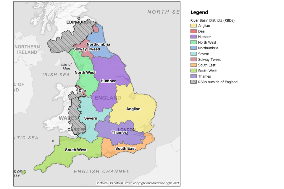
Map showing the 10 River Basin Districts in England
The map shows the 10 river basin districts in England: Solway Tweed, Northumbria, North West, Humber, Dee, Severn, Anglian, South West, Thames, South East.
In preparing the FRMPs, RMAs reviewed the first cycle FRMP objectives and measures. These were reviewed alongside existing and evolving plans and strategies, on a local and national level.
For the second cycle of FRMPs, there is a nationally consistent set of objectives which are closely linked to the:
-
Flood Risk Regulations 2009
-
national flood and coastal erosion risk management (FCERM) strategy and roadmap
-
25 year environment plan
You can find the full list of these objectives in the ‘objectives and measures for second cycle FRMPs’ section of this document. The measures (proposed actions to manage flood risk) have been developed in a consistent format.
In drawing the objectives and measures together, RMAs have revisited the priorities and made sure that there is a shared understanding of the main flood risks and how to manage them.
Developing the FRMPs
The approach to the second cycle plans is different to the first. In the first cycle, flood risk areas (FRAs) were identified for surface water only. For this second cycle, the Environment Agency chose to broaden the approach and apply the methodology to main rivers and the sea. This means that for the second cycle, there are FRAs for surface water and main rivers and the sea. It should be noted that the number of surface water FRAs has increased as the understanding of surface water mapping has improved.
With FRAs from main rivers, the sea and surface water, it provides the opportunity to produce each FRMP and its content to suit the particular characteristics of the river basin district (RBD).
For example:
-
the South East FRMP concentrates on the areas with the highest risk of flooding (FRAs)
-
the Dee and the Solway Tweed FRMPs consider the RBD as a whole
-
other FRMPs include additional information such as locally defined strategic areas, like the Humber Estuary
Each FRMP differs as to the level of detail included, depending on the characteristics and location of the RBD.
Consulting on the FRMPs
The FRMPs were consulted on from 22 October 2021 to 21 January 2022.
The Environment Agency and LLFAs worked with a wide range of stakeholders to help promote the draft FRMPs consultation. This included local government, the water industry, the farming industry, catchment partnerships and regional flood and coastal committees.
Environment Agency teams worked closely with their LLFAs and local stakeholders to promote the consultation and develop draft measures. A number of joint stakeholder events were carried out to coordinate for both FRMPs and RBMPs consultations.
A summary of responses was published on 18 May 2022.
Catchment based approach and FRMPs
The Catchment based approach (CaBA) encourages local engagement and participation in decision making.
The objectives for the catchment based approach are:
-
to deliver positive and sustained outcomes for the water environment by promoting a better understanding of the environment at a local level
-
to encourage local collaboration and more transparent decision-making when both planning and delivering activities to improve the water environment
These catchment based approach objectives inform our flood risk management work. For example the FCERM strategy roadmap and measures in the FRMPs. When preparing FRMPs and in carrying out FCERM activities, consideration has been given to how:
-
the processes across the catchment and coastline work and interact
-
drainage systems respond to different flood events
-
natural processes operate
FRMPs for RBDs which are also partially in Wales and Scotland
The Environment Agency is producing FRMPs for the English part of the Dee and Severn RBDs. Natural Resources Wales (NRW) are producing FRMPs for the Welsh part of the Dee and Severn RBDs. The Environment Agency is working closely with NRW to ensure a catchment based approach has been taken and that the plans complement each other’s. This is a change from the first cycle FRMPs where the Environment Agency and NRW worked together to produce a joint Severn FRMP and a joint Dee FRMP.
The Environment Agency and the Scottish Environment Protection Agency (SEPA) are producing separate FRMPs for the English and Scottish parts of the Solway Tweed RBD respectively. This is the same as in the first cycle FRMPs. The cross-border nature of the RBD means both English and Scottish authorities work together to coordinate flood risk management plans and proposed activities.
Where FRMPs are developed separately, RMAs work together to:
-
ensure measures proposed in cross-border areas are coordinated
-
reference each other’s plans
-
signpost to where each other’s plans are published
Flood plan explorer
Flood plan explorer (FPE) is a new, online, interactive map-based tool developed for this second cycle of flood risk planning. It has been developed specifically to display information about all the measures included within the second cycle FRMPs.
This information mainly includes:
-
where the measure is
-
a description of the measure and what it aims to achieve
-
which objectives the measure will help to achieve
-
who is responsible for implementing the measure
-
when the measure is planned to be implemented
FPE displays the approximate location of measures on a map, with more detailed spatial information displayed where available. FPE will also show how measures are progressing over the second planning cycle. You can find more information on how to use FPE within the tool itself and on linked help pages. These help resources will be updated with additional information over time. We plan for measure information to be downloadable using a separate software tool soon.
Objectives and measures for second cycle FRMPs
Two important elements of the FRMPs are the objectives for managing flood risk and the measures proposed to achieve those objectives.
Objectives for second cycle FRMPs
18 nationally-consistent objectives have been written for this second cycle of flood risk planning. In setting the objectives RMAs had regard to the flood risk regulations’ aims. These are to:
-
reduce the adverse consequences of flooding for human health, economic activity and the environment
-
reduce the likelihood of flooding
Climate change was also taken into account when developing these objectives.
They are consistent with the national FCERM strategy ambitions of:
-
climate resilient places
-
today’s growth and infrastructure resilient in tomorrow’s climate
-
a nation ready to respond and adapt to flooding and coastal change
The 18 FRMP objectives have been grouped under headings from the FCERM strategy and the FRRs as they have the same themes but separate legal drivers. The FCERM strategy objectives apply at the national scale. The FRMP objectives are more locally focused with Environment Agency, LLFAs and partners selecting which of the 18 objectives they want to apply locally.
Together, they call for the nation to embrace a broad range of resilience actions to better protect and prepare against flooding and coastal change, including nature based, avoiding inappropriate development in the floodplain and better preparing and responding to flood and coastal incidents through timely and effective forecasting, warning and evacuation.
On the FPE all the measures specify which of the 18 objectives they meet.
FCERM strategy ambition: climate resilient places
Flood risk regulations - reducing the likelihood of flooding
1. By 2027 risk management authorities will have developed a long-term strategic vision and delivery plan for managing future flood risk from all sources.
2. By 2027, risk management authorities will have worked together to develop and / or implement adaptive approaches that plan for a range of future flood and coastal change scenarios.
3. By 2027, risk management authorities will have worked with those communities that may be significantly affected by flooding and/or coastal change in the future and will have identified and/or be progressing the most appropriate flood risk management options.
4. By 2027, risk management authorities will have worked with communities, landowners and businesses to determine the level of maintenance of flood risk assets needed to manage flood risk, and they will have taken a risk-based approach to decide how or if they will be maintained in the future.
5. By 2027, risk management authorities will have worked with communities, landowners and businesses to understand wider maintenance activities needed to manage the risk of flooding and coastal change and who will contribute to make that happen.
6. By 2027, risk management authorities will have worked with communities, landowners and catchment, coastal and estuary partnerships, to identify and carry out schemes which work with natural processes to reduce the risk of flooding and coastal change.
Flood risk regulations - minimising the consequences of flooding for human health
7. By 2027, risk management authorities will have developed and/or delivered a programme of flood risk management capital schemes and/or maintenance to reduce risk of flooding and coastal change and its adverse consequences for human health and well-being.
Flood risk regulations - minimising the consequences of flooding for the environment including cultural heritage
8. By 2027, actions by risk management authorities to address current and future risk of flooding and coastal change will have helped achieve the environmental objectives set out in the river basin district’s river basin management plan.
9. By 2027, risk management authorities will have worked with catchment and coastal partnerships, landowners and managers and communities to make use of nature-based solutions to reduce the risk of flooding and coastal change and contributed to achieving wider environmental benefits.
10. By 2027, risk management authorities will have worked with Natural England and other partners to ensure that the delivery of flooding and coastal change risk management programmes have contributed to the local nature recovery strategies so that new and restored habitats contribute to reducing flood and coastal risk.
FCERM strategy ambition: today’s growth and infrastructure resilient in tomorrow’s climate
Flood risk regulations - minimising the consequences of flooding for economic activity
11. By 2027, risk management authorities will have worked with infrastructure owners, businesses and the community to identify priority infrastructure that needs to be made resilient to current and future risk of flooding and coastal change and will have discussed in partnership how this will be achieved and / or worked together to increase resilience.
12. By 2027, risk management authorities will have provided evidence and advice to infrastructure providers and supported them to take account of future flooding and coastal change in their infrastructure investment.
13. By 2027, risk management authorities will have worked with communities and businesses to understand and implement a plan for how flood and coastal erosion risk management activities can contribute towards sustainable growth and prosperity in a climate resilient way (and vice versa).
14. By 2027, and in line with national planning policy, new development in areas at risk will take into account the risk of flooding and coastal change now and in the future.
FCERM strategy ambition: a nation ready to respond and adapt to flooding and coastal change
Flood risk regulations - minimising the consequences of flooding for human health
15. By 2027, risk management authorities will have worked with communities to: raise awareness of the level of flood risk that they face: help them understand the role of emergency responders and ensure they know what to do in an emergency to help themselves.
16. By 2027, risk management authorities will have worked with communities to help them understand the potential impact of flooding and coastal change on their lives and livelihoods to encourage them to act.
17. By 2027, risk management authorities will have supported people living in places at risk of flooding and/or coastal change to develop and/or implement community led initiatives to be better prepared for, and resilient to, flooding.
18. By 2027, risk management authorities, local responders and other partners will have worked together to help people and businesses recover more quickly after flooding.
Measures for second cycle FRMPs
Measures that have been included in the second cycle are strategic. The aim of the FRMPs is not to describe all activities being planned or all local issues. For this second cycle of flood risk planning, the Environment Agency and LLFAs have developed measures that apply at a national level across the whole of England regardless of FRA designation. The national level measures have been introduced to cover all of the day-to-day activities which help manage flooding.
RMAs identified the measures to achieve the objectives. They selected the likely approach from the measure categories, which are described as:
-
preventing – by avoiding putting people or the environment at risk of flooding
-
preparing – by taking actions that prepare people for flooding
-
protecting – by protecting people from the risk of flooding
-
recovery and review – by learning from flood incidents
RMAs also identified whether these measures were:
-
ongoing (transitional) – measures already being carried out from the first cycle FRMP and have been transitioned to the second cycle FRMP
-
agreed – measures that have emerged since the first cycle FRMP was published and are included in the second cycle FRMP
-
proposed – new measures or significant changes to first cycle FRMP measures and are included in the second cycle FRMP
The level of detail that is provided on measures may vary depending on the planning or implementation stage measures are at. Information on measures can be found on FPE.
Some measures have an implementation status of ‘not started’. This will be because funding in place at the time of publication or it is due to start later in the cycle. We will report on overall measure progress through the flood and coastal erosion risk management annual report.
In determining the measures for the FRMPs, the main factors the RMAs considered were:
-
the costs and benefits of different methods of managing the flood risk
-
information included in the flood hazard map and the flood risk map
-
the river basin management plan for the RBD
-
the effect of floodplains that retain flood water
-
the environmental objectives for the RBD
-
the likely effect of a flood and of different methods of managing a flood, on the local area and the environment
In addition, there are also several other factors which the RMAs have considered when developing measures. These include other relevant legislation, local and national flood risk management policies, strategies and carbon impact.
Many of the measures also deliver environmental benefits and outcomes. Measures differ in terms of the environmental outcomes, and this will be monitored through FPE.
The natural capital approach applies economics to the climate and nature emergencies; it promotes integrated environmental management and; it uses common language and metrics to identify common interests and support collaborative delivery.
The Environment Agency are developing evidence, tools and capability to support the Environment Agency and partners to prioritise, fund and leverage more private-sector investment in nature based solutions and to promote local ownership and stewardship of natural resources.
The Environment Agency and other RMAs will work with partners and communities to carry out the measures. Not all measures in the FRMPs have secured funding and so they will not always be implemented. For some of these measures, RMAs can apply for FCERM grant-in-aid to help pay for the work, as set out in the government’s partnership funding policy. The Environment Agency administers this funding and allocates it in line with government policies and priorities.
When measures are implemented the sustainability and carbon impact will be considered throughout the delivery phase.
For the duration of the second cycle (2021 to 2027), the Environment Agency will work with LLFAs and other RMAs to monitor and measure progress. For information on how this will be undertaken please refer to the ‘how we will monitor implementation of the FRMP’ in each plan. The FCERM strategy roadmap includes a suite of actions that will help support the delivery the FRMP measures, such as mainstreaming NFM.
National level measures for second cycle FRMPs
The national measures were developed in consultation with national organisations representing LLFA’s. These are in addition to local measures for each individual FRMP.
There are several measures which are applicable across England. The Environment Agency plans to implement these national level measures as part of its routine day-to-day work as an RMA. The Environment Agency is responsible for the national level measures that apply to every FRA for main rivers and the sea.
LLFAs are responsible for the national level measures that apply to every FRA for surface water. Some of these measures are statutory (the work is required by law), and others are optional. LLFAs implement their routine work in different ways depending on local priorities and resources. You should look at LLFA websites and their local flood risk management strategies for more information on how they carry out their routine work.
These national level measures are in addition to any measures which have been developed locally for each FRMP.
The national levels measures aim to reduce the risk of flooding for:
-
agricultural land
-
businesses
-
the environment
-
historic sites
-
infrastructure
-
properties
Please note the above list is not exhaustive and includes all assets that have been formally designated (for example for their historic or environmental value) and those that haven’t.
The funding for projects that fulfil these measures will follow the government partnership funding policy and Environment Agency FCERM appraisal and partnership funding guidance.
You can find information about all the national level measures and those which have been developed locally in the interactive mapping tool, the flood plan explorer.
FCERM activities
The flood risk management plan (FRMP) measures include a range of flood and coastal erosion risk management (FCERM) activity. This section provides short descriptions of what some of these FCERM activities involve.
Strategic planning
RMAs use strategic planning to prioritise flood risk management activities, align investment with priority areas and achieve value for money. Where areas are at risk from more than one source of flooding, RMAs work in partnership to strategically plan across administrative and water boundaries.
Investigations
Lead local flood authorities (LLFAs) have a duty under Section 19 of the Flood and Water Management Act to formal investigations for some incidents of flooding in their area. These investigations identify which RMAs have relevant flood risk management functions, and whether they have exercised, or are proposing to exercise, those functions in response to the flood. The LLFA must publish the results of its investigation and notify any relevant RMAs.
Flood records and evidence
Records of past flooding are vital in informing flood risk management actions.
They are useful for:
-
understanding the sources, seasonality, frequency and impacts of flooding
-
identifying the likely locations, scale of expected flooding and the contributing factors
-
improving the response to future flood events
-
verifying and improving models which simulate floods
Communities and residents who have been affected by flooding are encouraged to report any floods to the relevant authority. This helps to improve the accuracy of evidence and information held by RMAs.
Hydraulic modelling and hydrology
Computerised hydraulic modelling is a process of simulating what happens to river levels during periods of rain and how water spreads across the floodplain. Hydrology, the science of estimating rainfall and river flows is used as input to the computerised hydraulic models. Analysis of past flood events is used to support the models’ predictions and improve their accuracy.
Coastal modelling looks at a combination of astronomical tides and storm surges, plus the impact of waves to assess the risk of flooding in coastal areas.
Surface water modelling assesses the impact of intense rainfall on a local area. It can also consider how overland flows interact with watercourses, sewers and drains.
RMAs use these models to predict where and when flooding is expected to occur and for how long, considering storm intensity and duration.
Hydraulic modelling also informs decisions about how flood risk could be managed. For example, to:
-
improve assets
-
provide planning advice to local councils to avoid inappropriate development
-
provide flood warnings and support flood incident management
Flood forecasting and warning
Weather forecasts can be used to predict how river flows and levels are expected to respond to changes in weather. The Environment Agency provides a flood warning service which uses rainfall and river level data for accuracy. Computer models of weather and tide conditions predict tidal flood forecasts. By providing flood forecasts and warnings, people can act in advance of potential flooding.
Providing an accurate flood forecasting and warning service is critical in managing the consequences of flooding. The Flood Forecasting Centre is a partnership between the Environment Agency and the Met Office. It combines expertise in meteorology and hydrology into a specialised hydrometeorological service to provide forecasts for all natural forms of flooding.
Incident planning and management
The Environment Agency, local councils, water companies, emergency services and other utility companies all plan for incidents of many types, including floods. These plans inform how the RMAs work together to respond to an incident and inform more strategic multi-agency response plans. Incident management exercises are used to test and improve planned response procedures. Following flood incidents partners review the plans to further improve procedures and share data.
Asset and river maintenance
To ensure flood risk management assets remain ‘fit for purpose,’ RMAs use permissive powers to carry out regular inspections and maintenance.
Examples of these assets include:
-
raised defences, such as earth embankments
-
river channel walls
-
culverts
-
outfalls and flap valves
-
pumping stations
-
flood storage reservoirs
The Environment Agency maintains an asset condition database which is updated after asset inspections. This information is used to inform maintenance decisions and funding requirements.
The Environment Agency uses its permissive powers to carry out river maintenance such as:
-
weed cutting
-
desilting
-
mowing banks
-
tree works
-
clearing blockages
You can find the Environment Agency’s 5 year asset maintenance programme online.
Other RMAs also maintain information relating to their assets, for example asset registers that are maintained by LLFAs. Using their permissive powers, LLFAs and IDBs undertake maintenance where they decide it is needed.
Improvement works
The Environment Agency produce flood maps using modelled and historic flood data to show areas where properties, communities and land are at risk of flooding. RMAs work with communities and partners to identify options that improve flood resilience and submit initial proposals to develop projects.
The Environment Agency coordinates a 6 year investment programme which allocates funding to projects that deliver improved flood resilience in line with the government’s partnership funding policy.
Nature based solutions
Nature based solutions can make a positive contribution to increasing local flood and coastal resilience. Natural flood management (NFM) does this by protecting, restoring and emulating the natural processes of catchments, rivers, floodplains and coasts.
These are often undertaken through partnerships between:
-
RMAs
-
farmers
-
landowners
-
environmental groups and charities
-
communities
In some places solutions involve making space for water away from vulnerable development. Examples include reconnecting rivers with their natural floodplain or creating new areas where water can be stored. Where there is space, NFM techniques can store and slow water running off land in response to rainfall, to help reduce flood levels downstream. This can include:
-
planting trees and hedges to absorb more water, catch rainfall and slow the flow of water on the ground surface when there is excess rainwater
-
covering the ground with plants to reduce water pollution and surface water run-off
-
diverting high water flows and creating areas to store water
-
creating leaky barriers to slow water flow in streams and ditches
-
restoring salt marshes, mudflats, and peat bogs
Nature based solutions for flood risk management can make an important contribution to improving the environment for wildlife and people by enhancing river and coastal waters, creating and improving natural habitats and helping with climate resilience. Nature based solutions can also result in less compacted and healthier soils which have greater capacity to absorb and store water. This infiltration slows the flow of water which can help to reduce flooding.
NFM can complement conventional flood or sea defences to enhance flood and coastal resilience. The initial findings of the natural flood management programme reinforces the benefits natural flood management can bring. These can include:
-
improved water quality
-
reducing soil erosion
-
health and wellbeing benefits from access to natural water courses
-
restoration of the climate resilience of land
-
improved habitats and biodiversity
-
landscape benefits both to wildlife and visually
-
conservation of historic landscapes and heritage areas
NFM relies on many local partners working together to achieve a shared vision for how they can reduce flood risk and improve their local environment.
Property flood resilience
Property flood resilience (PFR) is the term used to describe ways in which a property can be adapted to reduce damage from flooding. Using PFR enables households and businesses to recover from flooding more easily and reoccupy their property more quickly.
There are 3 aspects of PFR:
-
Resistance. This is the use of products or materials to reduce the chance of water entering a property. Common products used include flood doors or barriers, self-closing airbricks and non-return valves. It can also include other measures such as re-pointing brickwork, waterproof coatings on external walls and sealing around entry points where pipes and wires go through walls.
-
Recoverability. This is making adaptations designed to minimise the effect of floodwater if it does enter a property. Measures can include installing solid floors with ceramic tiles, raising electrics, using waterproof plaster on walls and installing a flood resilient kitchen.
-
Preparedness. This is ensuring property owners know how to prepare for a flood and what to do when flooding occurs. This can include signing up for flood warnings, moving items upstairs and keeping PFR products well maintained.
The Environment Agency is working with partners to increase the uptake of PFR measures, particularly in homes at high risk of flooding.
Sustainable drainage systems and green infrastructure
Sustainable drainage systems (SuDS) and green infrastructure are a way of managing surface water by reducing or delaying rainwater run-off. They aim to mimic the way rainfall drains naturally rather than conventional piped methods. This helps to manage flooding with other benefits such as reduced pollution, improved water quality and creation of habitats.
Common types of SuDS and green infrastructure are:
-
ponds which change in level with rainfall
-
swales
-
soakaways
-
permeable pavements
These methods use infiltration primarily and attenuation where infiltration cannot be achieved. Retrofitting of SuDS to sites is also a way of reducing peak flows in watercourses and so helping to reduce flooding and pollution and replenishment of groundwater.
Managing flood risk in rural areas
Many rural areas, particularly low-lying and pumped drained areas can be at high risk of flooding from rivers, the sea and surface water. Maintaining existing flood risk assets can help to reduce the risk in agricultural areas. RMAs will work with farmers and landowners to help them adapt their businesses and practices to be resilient to flooding and coastal change.
The importance of agricultural land for food production is discussed in depth in the government’s food strategy that focuses on longer-term measures to support a resilient, healthier, and more sustainable food system. Agriculture brings a large number of benefits such as: thousands of jobs, ecosystem biodiversity, landscape and character, carbon sequestration, and water quality. However, farming can contribute to flooding through poor land management practices which could increase the speed that water enters rivers or cause localised surface water problems. Communities and businesses, including landowners and farmers in the countryside, have an important role to play in managing and reducing flood risk and increasing their resilience to floods.
This can include:
-
putting in place nature based solutions to enable land to slow the flow or store and harvest water
-
maintaining gullies and roadside ditches to manage surface water
-
taking action to keep livestock and equipment safe during a flood
The catchment sensitive farming (CSF) programme can help to reduce flood risk. CSF officers work in catchments with farming communities to drive voluntary practice change over the long term. They use a wide variety of advice tools and incentives, including CSF officer advice, contracted specialist advice and Countryside Stewardship.
Resilience and adaptation
The national FCERM strategy calls for the nation to embrace a broad range of resilience actions including better protection to flooding and coastal change. It frames resilience in terms of the capacity of people and places to plan for, better protect, respond to, and recover from flooding and coastal change.
This includes:
-
making the best land use and development choices
-
protecting people and places
-
responding to and recovering from flooding and coastal change
This is at the same time as adapting to climate change. Adaptation means anticipating appropriate action to prevent or minimise the likelihood and consequences of flooding and coastal change, both now and in the future.
Looking out to the year 2100, we need to help local places better plan and adapt to future flooding and coastal change and adapt to future climate hazards. For practitioners and policy makers, this means remaining agile to the latest climate science, growth projections, investment opportunities and other changes to our environment.
An adaptation pathway is a decision-making approach that enables practitioners and policy makers to identify what actions can be taken now and in the future. Taking an adaptive approach is recommended in the government’s green book supplementary guidance.
It’s about making the right decisions at the right time. Adaptive pathways can also reduce the overall cost of flood and coastal risk management in the longer term by timing investments when they provide maximum benefit.
Development planning and control
RMAs work together to avoid inappropriate development in areas at risk of flooding. They also work together to seek opportunities through sustainable development to reduce the causes and impacts of flooding. The national planning policy framework (NPPF) includes policies on flood risk and coastal change. These must be applied by local planning authorities (LPAs) when preparing local plans and determining planning applications.
The Environment Agency is a statutory consultee for development proposals:
-
in areas that are currently at medium or high risk of flooding from rivers and the sea
-
in areas with critical drainage problems
-
within 20 metres of a main river
LLFAs are a statutory consultee on major development with surface water drainage.
EA and LLFAs provide advice to local planning authorities who make the final decision. Other RMAs may also be consulted and may choose to provide advice on development proposals.
Regulation – permitting and enforcement
Construction works or maintenance activities can increase flood risk, impede drainage and/or cause environmental damage if poorly executed. The public and businesses must therefore apply for permission from the relevant RMA to carry out certain types of activities on or near rivers, streams and defence structures. This is to avoid these problems being created. This regulation is a legal duty. RMAs must consider proposals submitted under legislation and decide whether to allow them or not. If problems arise, RMAs may have powers to take enforcement action against someone acting without formal permission, or in breach of it. This is to correct the damage caused by their actions.
Working with communities
RMAs, non-governmental organisations (NGOs), communities and individuals work together to manage flood risk.
They do this through:
-
RMA support of community planning for and response to flood incidents
-
collaborative decision-making on flood and coastal change mitigation options and long- term strategic planning
RMAs work in partnership with community representatives such as flood groups and NGOs who represent flood volunteers. These include the national flood forum and action with communities in rural England.
Strategic environmental assessment
The Environment Agency must carry out a strategic environmental assessment (SEA) of some of its plans. This is to meet the legal requirements of the Environmental Assessment of Plans and Programmes Regulations (England) (SI 2004 1633) - the ‘SEA Regulations’. An SEA enables the development of plans that will lead to better and more sustainable environmental outcomes.
The Environment Agency determined that an SEA was needed for the second cycle flood risk management plans (FRMPs) to meet the requirements of the SEA regulations. The likely significant effects of measures on the environment were assessed as the plans were developed. This has enabled RMAs to make changes to the plans to protect the environment by avoiding or reducing harmful effects. It has also allowed RMAs to make the most of opportunities to enhance the environment.
The findings of the SEA for the draft second cycle FRMPs were documented in an environmental report. The environmental reports were published alongside each of the draft second cycle FRMPs for consultation between 22 October 2021 and 21 January 2022.
Following the review of the consultation responses and production of the final second cycle FRMP, the SEA findings have been checked and updated where required. This has been documented in a statement of environmental particulars (SOEP), for each second cycle FRMP.
The SOEP sets out how:
-
we have integrated environmental considerations into the FRMPs
-
we have taken into account the findings of the SEA
-
opinions expressed in response to the consultation on the SEA Environmental Report have been taken into account
-
reasons for selecting the FRMP as adopted
-
we will monitor the likely significant environmental effects of implementing the FRMP
For further information please see the SOEP.
Habitats regulation assessment
The Conservation of Habitats and Species Regulations 2017 (as amended) requires that the plans consider the potential for direct and indirect effects on the integrity of sites designated for their international importance. These sites are collectively referred to as European sites because they contain species and habitats that are the best examples at a European scale. The potential for effects of the integrity of these sites is assessed through a habitats regulation assessment (HRA). A HRA has been undertaken for each of the second cycle FRMPs.
Climate change and FRMPs
The 2018 UK climate change projections suggest that average sea level could increase by over a metre by the end of the century and that there could up to 59% more precipitation in winters by 2050. This could lead to more river flooding. Rainfall intensity will increase, which will lead to more surface water flooding. There is already evidence of more frequent and more extreme flooding and faster and more extreme coastal erosion.
Climate change has been considered in the FRMPs by:
-
aligning the FRMP objectives with the ambitions of the FCERM strategy
-
developing FRMP measures to meet those objectives
-
including national and local FRMP measures which seek to reduce carbon emissions
-
considering the likely impact of climate change on the occurrence of floods for each river basin district
You can find out more about the potential impacts of climate change on the likelihood of coastal, river and surface water flooding for each river basin district in the 10 individual FRMPs. It should be noted that these plans are strategic and therefore detailed and updated information on climate change should be assessed further at project level.
As the data that is used to predict the impact of climate change is constantly changing the most up to date information has been used at the time of publishing, over the next 6 years as this changes the most up-to date information should be used.
The Environment Agency, produces the following guidance to support decision making:
-
planning guidance (for local planning authorities to comply with the national planning policy framework - climate change allowances flood risk assessments.
-
Flood and coastal risk projects, schemes and strategies: climate change allowances to design flood risk infrastructure.
Our changing climate will also affect coastal erosion, water quality and the wider water environment. The impacts on these is explored further in shoreline management plans (SMPs) and river basin management plans (RBMPs) respectively.
Coordination of FRMPs and river basin management plans (RBMPs)
Alongside flood risk management planning, the Environment Agency works with others to protect and improve the quality of the water environment. It does this through river basin management. The Environment Agency has co-ordinated production of the FRMPs and the river basin management plans updated 2022 (RBMP 2022) to encourage better join-up in the management of flood risk and the water environment. This will help to deliver more integrated water solutions that help both flood and drought resilience as well as water quality issues and nature recovery.
The aim of RBMPs is to enhance nature and the natural water assets that are the foundation of everyone’s wealth, health and wellbeing, and the things people value, including culture and wildlife. The RBMPs contain legally binding local objectives for the water environment and describe the evidence base that informs regulatory, investment and development planning decisions. The current 25YEP target of 75% of waters being in a close to natural state is based on these plans.
RBMPs are updated every 6+ years to reflect feedback from public consultation. Consultation on the draft RBMPs 2021 demonstrated that the public are really engaged with the water environment and want to see it improve.
The Environment Agency has worked with LLFAs and other RMAs to develop joint measures in both FRMPs and RBMPs to reduce flood risk and improve the wider water environment. Aligning measures also helps to simplify the delivery of outcomes and make it more efficient.
The RBMPs updated 2022 are expected to be published on gov.uk in December 2022. You can find more information on the objectives and proposed measures to improve the water environment by looking at the draft RBMPs.
FRMPs and other plans and strategies
FRMPs are part of a small number of strategic plans that form a framework to manage flooding, coastal change and the wider water environment. These strategic plans:
-
are produced by the Environment Agency, LLFAs and other RMAs
-
cover different spatial scales for example national, river basin district, coastal cell, or a local area
-
are produced for different purposes, such as emergency flood management, strategic flood management or land management
-
are both statutory (required by law) or non-statutory
The framework allows for the assessment of risk from all sources of flooding and coastal change. It requires close engagement across all RMAs, to ensure an integrated range of solutions in creating a better place for people and wildlife.
In its 2020 FCERM policy statement, the government made a commitment to reform local flood and coastal erosion risk planning by 2026. This is so that every area of England will have a more strategic and comprehensive plan that drives long-term action and investment.
Some of the other main plans in flood and coastal erosion risk management (FCERM) are included in this section, together with a brief description of what they are. These are in addition to the national FCERM strategy and RBMPs which have been described previously in this document.

The current cycle of DWMPs are non-statutory. The 2023 - 2028 DWMPs will be made statutory.
The diagram shows the strategic plans in place for managing the water environment in England.
At a national level:
- the statutory national FCERM strategy from the Environment Agency covers strategic flood management
- the national planning policy framework and guidance from MHCLG covers land use
They cover all sources of flooding.
River basin districts and coastal cells have plans in place through strategic flood management described in:
- the statutory flood risk management plans from the Environment Agency and lead local flood
- the statutory river basin management plans from the Environment Agency
- the non-statutory shoreline management plans from the Environment Agency
These plans cover all sources of flooding.
At a local level:
- the non-statutory multi agency flood plan from local resilience forums cover emergency management
- the statutory local flood risk management strategies from lead local flood authorities cover strategic flood management
- the non-statutory drainage wastewater management plans from water companies cover strategic flood management
- the non-statutory local plan for place, growth and development from local authorities cover land use
The multi agency flood plan and local plan for place, growth and development cover all sources of flooding. The local flood risk management strategies and drainage and wastewater management plans are the most important plans flooding from surface water.
Local flood risk management strategies
All LLFAs have a duty under the Flood and Water Management Act 2010 to prepare a local flood risk management strategy (LFRMS) for their area. The LFRMS includes aims and actions to reduce the risk of all sources of local flooding to communities.
Sources of local flooding are:
-
surface water
-
groundwater
-
ordinary watercourses
The LFRMS also includes information such as:
-
RMAs within the LLFA’s area
-
costs, benefits and an assessment of funding sources to manage local flood risk
-
how and when the strategy is to be reviewed
-
how the strategy contributes to wider environmental objectives
You can find a copy of each LLFA’s LFRMS on their individual websites. The LGA, ADEPT and Environment Agency collaborated on updating the guidance, which was published in March 2022.
Drainage and wastewater management plans
Drainage and wastewater management plans (DWMPs) are the new way for organisations to work together to plan for the future of drainage, wastewater and environmental water quality. They are long-term strategic plans which include the actions needed across England to ensure wastewater systems and drainage networks are sustainable and resilient to future pressures. These pressures include population growth and climate change.
A DWMP will be produced for each of the wastewater areas served by water companies in England. Water and sewerage companies will publish draft DWMPs in the summer of 2022 and final plans by May 2023. Guiding principles set out the priorities and expectations for DWMPs of the UK and Welsh Governments’, Environment Agency and Ofwat. The Environment Act 2021 allows the drainage and wastewater management plans to be made statutory. Government will implement the relevant provisions during the next drainage and wastewater management planning cycle (2023 - 2028).
Shoreline management plans
Shoreline management plans (SMPs) cover the English coastline and some are considered to be world leading in planning for coastal adaptation. There are 20 shoreline management plans produced and updated by coastal groups in consultation with local communities and local partners. The plans identify a sustainable management approach for each stretch of coastline, based on 4 policy options that can change across 25 year time horizons:
-
hold the line: maintaining or upgrading the level of protection provided by defences
-
advance the line: building new defences seaward of the existing defence line
-
managed realignment: moving or allowing the retreat of the shoreline and the creation of inter-tidal habitat where appropriate
-
no active intervention: a decision not to invest in providing or maintaining defences. This requires engagement and adaptation where it affects communities
They are developed by coastal groups, with members mainly from local councils (coast protection authorities) and the Environment Agency. SMPs are non-statutory, policy documents which identify the most sustainable approach to managing the flood and coastal erosion risks to the coastline in the:
-
short-term (0 to 20 years)
-
medium-term (20 to 50 years)
-
long-term (50 to 100 years)
The Environment Agency is working closely with the coastal groups to refresh all the SMPs covering the English coastline. This is to make sure they remain fit for purpose and reflect the need to plan and adapt to rising sea levels and a changing climate. The SMPs align with, and inform other strategic plans including flood risk management plans and river basin management plans.
Other strategic plans in managing the water environment
Below is a list of other strategies and plans that manage the water environment. Please note that this list is not exhaustive.
Multi-agency flood plans (MAFPs) are non-statutory plans produced by local resilience forums (LRFs). These plans contain information of possible flood sources and areas of risk and the associated emergency response arrangements.
The FCERM strategy roadmap sets out important practical actions needed to achieve the 3 ambitions in the FCERM strategy.
The national planning policy framework (NPPF) sets out the government’s planning policies for England and how these should be applied. This includes how the planning system should consider flood risk and coastal change. It is produced by the Ministry of Housing Communities and Local Government.
Local plans are statutory plans produced by local planning authorities. They set out the planning policies in a local authority area. They must be consistent with national policies, including the NPPF.
Local nature recovery strategies are a new, England-wide system of spatial strategies that will establish priorities and map proposals for specific actions to drive nature’s recovery and provide wider environmental benefits.
Environmental land management schemes (ELMs) are Agricultural incentives intended to support the rural economy while achieving the goals of the 25 Year Environment Plan and a commitment to net zero emissions by 2050.
Marine plans set out priorities and directions for future development, inform sustainable use of marine resources and helps marine users understand the best locations for their activities, including where new developments may be appropriate. They are produced by the Marine Management organisation.
Coastal concordat sets out the separate processes for consenting coastal developments in England. It supports decision-making between local authorities and those regulators who work in the marine area. The government’s 25 year environment plan aims for all local authorities with a coastal interest to adopt the concordat by 2021.
The England trees action plan sets out our long-term vision for trees, woodlands and forests in England and the actions up to 2024.
Woodlands for water considers the key issues relating to the use of woodland measures for meeting water framework directive (WFD) objectives.
The England peat action plan is an integrated plan for the management, protection and restoration of our upland and lowland peatlands, so that they deliver benefits for nature and the climate.
List of abbreviations
This list of abbreviations is intended as a reference tool. It includes the main abbreviations and terms used in the second cycle flood risk management plans.
| Short form | Long form |
|---|---|
| AONB | area of outstanding natural beauty |
| CaBA | catchment based approach |
| CDE | catchment data explorer |
| Defra | Department for Environment, Food and Rural Affairs |
| DWMP | drainage and wastewater management plan |
| EIA | environmental impact assessment |
| ELMS | environmental land management scheme |
| EPR | environmental permitting regulations |
| FAG | flood action group |
| FCERM | flood and coastal erosion risk management |
| FPE | flood plan explorer |
| FRA | flood risk area (as identified under the Flood Risk Regulations 2009) |
| FRM | flood risk management |
| FRMP | flood risk management plan |
| FRR | flood risk regulations 2009 |
| FWMA | Flood and Water Management Act 2010 |
| HRA | habitats regulations assessment |
| IDB | internal drainage board |
| LEP | local enterprise partnership |
| LFRMS | local flood risk management strategy |
| LLFA | lead local flood authority |
| LPA | local planning authority |
| MHCLG | Ministry of Housing, Communities and Local Government |
| MMO | Marine Management Organisation |
| NaFRA | national flood risk assessment |
| NFM | natural flood management |
| NNR | national nature reserve |
| NPPF | national planning policy framework |
| NRW | Natural Resources Wales |
| PFRA | preliminary flood risk assessment |
| RBD | river basin district |
| RBMP | river basin management plan |
| RFCC | regional flood and coastal committee |
| RMA | risk management authority |
| RoFSW | risk of flooding from surface water |
| SAC | special area of conservation |
| SEA | strategic Environmental Assessment |
| SEPA | Scottish Environment Protection Agency |
| SMP | shoreline management plan |
| SPA | special protection area |
| SSSI | site of special scientific interest |
| SuDS | sustainable drainage systems |
| SWMP | surface water management plan |
| UKCP18 | UK Climate Projections 2018 |
| WFD | Water Framework Directive |
Glossary
This glossary is intended as a reference tool. It includes the main terms used in the second cycle flood risk management plans and a short description of what they are.
25 year environment plan:
A plan produced by government which sets out goals for improving the environment, within a generation and leaving it in a better state. It details how government will work with communities and businesses to do this over the next 25 years.
Catchment:
The area from which precipitation contributes to the flow from a borehole spring, river or lake. For rivers and lakes this includes tributaries (a river or stream flowing into a large river or lake) and the areas they drain.
Coastal erosion:
The loss of land due to the effects of waves and, in the case of coastal cliffs, slope processes (such as high groundwater levels). This may include cliff instability, where coastal processes result in landslides or rock falls.
Flood risk area:
Areas identified through the PFRA process where the risk of flooding is significant nationally for people, the economy or the environment (including cultural heritage).
Flood risk management plan:
A statutory plan prepared by the Environment Agency and LLFAs under the Flood Risk Regulations 2009. The plans are reviewed and updated every 6 years. The current plans cover the period 2021 to 2027.
Flood risk and hazard mapping:
Maps prepared under the Flood Risk Regulations 2009 to show potential risks and impacts of flooding in identified flood risk areas. They are reviewed and updated every 6 years. The current maps use data and risk assessment data available in December 2019.
Flood plan explorer:
A new, online, map-based tool which displays all of the measures proposed as part of the second cycle of flood risk management plans in England.
Fluvial flooding:
Flooding from/of rivers.
Groundwater flooding:
Occurs when water levels in the ground rise above the natural surface. Low-lying areas underlain by permeable layers are particularly susceptible.
Internal Drainage Board:
A public body that manages water levels in areas known as internal drainage districts.
Internal drainage district:
Areas where there are special drainage needs, managed by internal drainage boards.
Lead local flood authority:
These are county, unitary or metropolitan boroughs that are responsible for managing flooding from surface water, smaller watercourses and groundwater. There are 152 in England.
Local flood risk management strategy:
Statutory strategies produced by lead local flood authorities under the Flood and Water Management Act 2010.
Main river:
A watercourse shown as such on the main river map. They are usually the larger rivers and streams, and for which the Environment Agency has responsibilities and powers.
Management catchment:
An amalgamation of a number of river water body catchments that provide a management unit.
National flood and coastal erosion risk management strategy:
A statutory strategy prepared under the Flood and Water Management Act 2010, by the Environment Agency for England.
Ordinary watercourse:
A watercourse that does not form part of a main river and is not shown on the main river map. LLFAs, district councils and internal drainage boards may carry out flood risk management work on ordinary watercourses.
Preliminary flood risk assessment:
The first stage in the six-year planning cycle to deliver the flood risk regulations. The latest PFRAs were reviewed in 2017 for local sources of flood risk and 2018 for main rivers, the sea and reservoirs.
Preparedness measure:
A measure (action) which aims to prepare people for flooding. Examples include flood forecasting and warning, flood emergency response planning and improving public preparedness for flooding.
Prevention measure:
A measure (action) which aims to avoid putting people or the environment at risk of flooding. Examples include watercourse regulation, flood risk modelling and mapping and development planning and control.
Protection measure:
A measure (action) which aims to better protect people from the risk of flooding. Examples include building flood defences, nature based solutions and asset maintenance.
Recovery and review measure:
A measure (action) which aims to use learning from flood incidents. Examples include reviewing lessons learnt from flood response, supporting communities businesses and the environment to recover from flooding.
Reservoirs:
A natural or artificial lake where water is collected and stored until needed. Reservoir owners and operators (‘undertakers’) must meet certain requirements under the Reservoir Act 1975.
River basin district:
Large river catchments in England. They cover an entire river system, including river, lake, groundwater, estuarine and coastal water bodies.
River basin management plan:
Statutory plans developed by the Environment Agency which set out how organisations, stakeholders and communities will work together to improve the water environment.
River flooding:
Occurs when water levels in a channel overwhelms the capacity of the channel.
Services:
Services include schools, hospitals, nursing/care/retirement homes, police stations, fire and ambulance stations, prisons, sewerage treatment works and electricity installations.
Sewer flooding:
Flooding as a result of overloading of the sewerage system due to limited system capacity or failure of sewer asset.
Strategic area:
A locally defined area included in the flood risk management plans. They are areas with a similar geography or strategic ambition where it is important to consider flood risk management across administrative boundaries and river catchments.
Surface water flooding:
Occurs when intense rainfall overwhelms local drainage capacities.
Tidal flooding:
The temporary inundation of coastal areas during exceptionally high tides or storm surges.
Tide locking:
Occurs when the level of the incoming high tide stops the river water from flowing out to sea. This can increase the risk of river flooding.