UK Geospatial Strategy 2030
Updated 3 August 2023

© Crown copyright 2023
This publication is licensed under the terms of the Open Government Licence v3.0 except where otherwise stated. To view this licence, visit nationalarchives.gov.uk/doc/open-government-licence/version/3 or write to the Information Policy Team, The National Archives, Kew, London TW9 4DU, or email: psi@nationalarchives.gov.uk.
Where we have identified any third party copyright information you will need to obtain permission from the copyright holders concerned.
This publication is available at https://www.gov.uk/government/publications/uk-geospatial-strategy-2030/uk-geospatial-strategy-2030
About the Geospatial Commission
The Geospatial Commission was established in 2018 by the government as an expert committee responsible for setting the UK’s geospatial strategy and coordinating public sector geospatial activity. We are part of the Department for Science, Innovation and Technology, playing a crucial role to deliver improved public services, create new better-paid jobs and grow the economy.
Our aim is to unlock the significant economic, social and environmental opportunities offered by location data, applications and services and to advance the UK’s global geospatial expertise. The Geospatial Commission has a mandate to research, initiate, drive and deliver changes by working in partnership with others. This means we:
- Provide strategic oversight of the geospatial ecosystem in the UK, setting geospatial strategy, policy and standards
- Hold the budget for the public sector’s largest investment in location data, the Public Sector Geospatial Agreement (PSGA)
- Make targeted investments in projects that accelerate innovation and adoption of location data, applications and services
Our approach to delivery is:
- Use and value driven - We prioritise action in areas where there is evidence of the greatest opportunity and impact.
- Iterative - We will achieve our vision by exploring new ideas, learning through pilot projects and monitoring innovation.
- Whole-system - We take a whole-system approach, considering not only technology and data, but also leadership, governance, policies, organisations, legal frameworks, security and skills.
- Collaborative and open - We work with others to achieve our missions, which require collective effort in connecting people and systems. Organisations across the nations and regions of the UK, in public, private and third sectors, play an important role. We learn from, and work with, other countries.
Ministerial foreword

Viscount Camrose, Minister for AI and Intellectual Property
Location data is fuelling the technological revolution. Geospatial applications are driving economic growth, improving public services and underpinning environmental recovery. This strategy positions the UK to fully realise geospatial benefits across the economy.
We depend on a sense of place to understand the world - what is happening around us and in distant places. Location services are a crucial part of our everyday life. Live location data allows us to plan a car journey or track a bus, find a local restaurant or share our location with friends. Businesses use location data to be more efficient and provide new and better services and it enables emergency services to reach an incident quickly. This technology has become so ubiquitous, we all expect to access our location wherever we are, whenever we need it.
Location-based insight was historically delivered by explorers and entrepreneurs who drew the first maps of our country, cities and towns. Today such insights are driven by scientists and technologists using cutting edge data collection equipment, from location sensors in watches and phones to satellites and the James Webb telescope, whose journey across space we could track live, as it travelled a million miles from Earth, to help us understand our place in the universe[footnote 1].
The UK is reliant on modern location data, services and technologies. They are vital to secure our borders, to understand how our coastlines will be affected by climate change, to roll out national infrastructure and to anticipate how the impact of decisions will vary across geographic regions of the UK and its dynamic population.
We are well-placed to maximise the benefits of geospatial innovation, with a thriving and globally recognised geospatial ecosystem. We rank second in the global geospatial readiness index. Dedicated geospatial companies in the UK have generated over £6 billion in annual turnover and employ over 30,000 people, securing over £1 billion in equity investment since 2016[footnote 2]. The UK is home to national geospatial organisations with world-leading expertise and foundational data, including our public sector geospatial partner bodies.
However, our future advantage in this field is not assured. The geospatial ecosystem is being transformed and disrupted by advances in technology and there remains limited awareness of the full value of geospatial applications. We must make sure that the UK is equipped to face a future shaped by technological advancement.
This government has set a clear goal to secure the UK’s position as a science superpower and that is why direct funding for UK research and development will reach £20 billion a year by 2024/2025. Within the new Department for Science, Innovation and Technology, the Geospatial Commission is at the heart of the government’s work to drive innovation that will deliver improved public services, create new, better paid jobs and grow the economy.
This updated UK Geospatial Strategy builds on the approach set out in the 2020 Strategy and aligns with the UK Science and Technology Framework published in March this year. It ensures that we are in a strong position to capitalise on geospatial opportunities arising from the technological revolution.
I am delighted by what the Geospatial Commission has already achieved and look forward to working with the Board of Commissioners and the Geospatial Commission team and partners to drive forward this important agenda.
Viscount Camrose
Minister for AI and Intellectual Property
Board of Commissioners foreword
Location data has proven its enduring value again and again - during the coronavirus (COVID-19) pandemic, tracking outbreaks across the country was critical to inform public health decisions. It will continue to underpin solutions to our biggest challenges including climate change, energy security, economic growth and national security.
The Geospatial Commission and partners are determined to play our part in continuing to enrich the geospatial contribution. Over the three years since we published the UK’s first geospatial strategy we have:
Built and launched NUAR as a minimum viable product
We launched the National Underground Asset Register (NUAR) minimum viable product in North East England, Wales and London. This is the result of collaborative work with hundreds of organisations from the public and private sectors. NUAR will make the management of our buried infrastructure safer, faster and cheaper.
Renewed and modernised key public sector contracts
We invested over £1 billion, through the Public Sector Geospatial Agreement (PSGA) with Ordnance Survey, to enable better access to location data for 5,500+ public sector organisations across the country. We agreed a new five year contract for the Postcode Address File Public Sector Licence with Royal Mail, providing public bodies with access to over 30 million business and residential addresses to support delivery of vital public services and combining for the first time previously separate agreements for England and Wales, and Scotland.
Increased coordination around foundational UK datasets in the public sector
We and our six partner bodies supported increased coordination around foundational UK datasets in the public sector, enabling data improvement through the use of FAIR (findability, accessibility, interoperability, and reusability) data standards and alignment in strategic direction, project delivery and international representation.
Established new programmes in key opportunity areas
We set up new programmes in the transport and property sectors and in land use decision making. We invested £5 million in private sector innovation to solve major transport sector challenges through product development and testing. We also explored ground-breaking use cases that will push the boundaries of geospatial applications to support key UK priorities, including the transition to electric vehicles and the building of new homes.
Advanced geospatial policy in the UK and internationally
We surfaced and made progress on central policy considerations, such as how we define and value the growing geospatial marketplace in the UK. We engaged with the public on ethical use of location data and technologies, and published guidance to support investment cases for improved access to geospatial data and technologies. With Great Britain’s national mapping agency, Ordnance Survey, and others, we continued to put the UK at the forefront of international geospatial policy and standard setting developments.
Looking to 2030
Of course, our work is not done. Technological innovation has the capacity to surprise and thrill us and the pace of change is not abating. This creates new opportunities to innovate with location data and new applications to explore. In the years ahead we will build on our foundational activity to date and develop our established programmes, as well as exploring new opportunities.
Looking to 2030, the UK government’s science and technology agenda sets a compelling vision that will help us meet the challenges of the digital revolution. This strategy aligns with the UK Science and Technology Framework, published in March 2023, which underlines that science and technology will be the major driver of prosperity, power and history-making events this century.
Our missions support the drive towards the adoption of critical technologies and continued investment in UK research and development. We are proud to be part of the new Department of Science, Innovation and Technology, which provides the perfect platform to bring geospatial policy into the heart of this agenda and to support wider government priorities from net zero to levelling up.
Finally, we would like to thank the many people and organisations involved in the work to update the UK Geospatial Strategy, including the numerous Call for Evidence respondents, our geospatial partner bodies and our colleagues in the devolved administrations whose collaborative approach has helped to shape this document and ensure examples of best practice from across the UK. The Strategy, with its refreshed missions, sets us up to realise the opportunities of the future, but it can only be achieved through our collective effort across the UK and across private, public and third sectors.
Sir Bernard Silverman
Chair
Nigel Clifford
Deputy Chair
Professor Louise Heathwaite CBE
Independent Commissioner
Alexandra Notay
Independent Commissioner
Steve Unger
Independent Commissioner
Section 1: Executive summary
Context
Geospatial applications and services have become an intrinsic part of everyday life, enabling routine activities and improving individual consumer experiences from instant journey planners to ever faster delivery of goods. The insights that these services provide are vital for businesses and the delivery of public services.
The potential of location data is enhanced by enabling technologies, such as artificial intelligence (AI) and cloud computing, which have caused disruption and opened up huge new capabilities. To make the most of these enabling technologies it will be essential to overcome limiting factors, such as a lack of awareness and skills.
Against that backdrop, this update to the UK’s Geospatial Strategy provides a timely opportunity to reflect on the latest trends and challenges impacting the geospatial ecosystem. Our renewed three missions position the UK’s long term direction towards key priorities of driving technological innovation, realising benefits of applications of location data across the economy and building confidence in the geospatial ecosystem. The actions within these missions set out the first concrete steps towards these goals.
Mission 1: Embrace enabling technologies to accelerate geospatial innovation
The UK geospatial ecosystem must continue to embrace emerging technologies if the UK is to remain at the forefront of innovation. This will require effective partnerships across academia, industry and the public sector, to focus on research and development, and the fostering of innovation from seed to scale-up and implementation.
Market intelligence and other enabling technologies
- Over the coming years we will continue to build our understanding of the geospatial ecosystem, providing an informed view of the potential impacts of disruptive technologies and outlining the opportunities and risks that they present
- We will work with public sector partners, such as UK Research and Innovation (UKRI), to drive coordination and direction in public sector funding for geospatial research and development
Remote sensing
- By autumn 2024 following the conclusion of our earth observation pilot, we will publish key findings covering how the public sector’s access to and innovative use of earth observation data can be supported
- By the end of 2024 we will conduct a review of the remote sensing market, including a review of the existing collective procurement of aerial photography for the public sector, with a view to exploring future access models
Population movement data
- By summer 2024 we will publish an assessment of the market for data about population movement, including its strategic importance, privacy and security implications and use in the public sector
Mission 2: Drive greater use of geospatial applications and insights across the economy
There remains significant potential to increase both the awareness and capability to deploy geospatial applications across many areas of the economy. We believe that increased awareness of the power of location data, technology and services can be achieved by driving and publicising the delivery of high value geospatial applications.
Underground infrastructure
- By spring 2024 we will roll out the current, minimum viable product version of the National Underground Asset Register (NUAR) beyond Wales, London and North East England to the remaining regions in England and Northern Ireland
- By the end of 2025 NUAR will be fully operational
Land use
- By the end of 2024 we will explore the creation of a Land Use Analysis Taskforce, which will bring together, through appropriate new cross-departmental governance, a shared spatial analysis capability to provide a spatially-explicit evidence base that will help inform the delivery of key national priorities
- Throughout 2023 we will promote the prototype decision support and visualisation tools developed through our National Land Data Programme (NLDP) pilots to highlight the potential of these applications to support emerging policy needs around local land use decision making
- By autumn 2024 we will consider how government, academia and industry practitioners involved in land use decision making can improve links, including through the dissemination of outputs and common modelling assumptions and scenarios
- By spring 2024 we will develop with partners a standard taxonomy for key land use data to support improvements to the interoperability of land use data and analysis
Targeted sectors
- By summer 2023 we will publish our findings on how geospatial applications can enable the delivery of connected and automated mobility
- By autumn 2023 we will share our findings for the public sector to make more informed decisions about electric vehicle chargepoint locations, as set out in our report Getting to the Point
- By summer 2023 we will publish our findings on opportunities to unlock greater value across the property ecosystem through location data, technologies and services
- By the end of 2024 we will publish a report identifying the cross-cutting challenges and opportunities for location data in the health sector
Public sector
- By spring 2024 we will conduct a review of the Public Sector Geospatial Agreement (PSGA) to ensure it remains fit for purpose over the remaining seven years of the agreement, including an evaluation of: the data and services included in the agreement; its delivery model; and the foundations users have in place to make effective use of data provided under the agreement
- By summer 2024 we will undertake new research, with partners such as the Office for National Statistics, to understand the implications of geographic changes to where people work and land used for employment
Mission 3: Build confidence in the future geospatial ecosystem
As advances in geospatial help us overcome key challenges, it is imperative that the UK continues to create an environment in which the geospatial ecosystem can flourish - both today and in the future. This means ensuring that all parts of the ecosystem, domestically and abroad, continue to have confidence in the innovative use of geospatial applications.
International
- We will remain committed to the UN Committee of Experts on Global Geospatial Information Management (UN-GGIM), including through the UK’s engagement in meetings of the expert committee
- In 2024 we will partner with UK stakeholders to deliver an international geospatial conference on the power of location
A strategic approach to data access
- We will continue to build on the experience from key Geospatial Commission projects to identify best practice about sustainable data access
Skills
- By summer 2024 we will publish an evaluation of the Data, Digital, Diversity Training pilot programme to assess the value of this approach to upskilling geographic experts with digital skills
- By summer 2024 we will work with universities to publish best practice as a first step towards embedding geospatial into data science and geography courses
- We will continue to support the Government Geography Profession to improve geospatial capability throughout the public sector
Section 2: The location opportunity
The power of location
Knowing where things are has always been fundamental to understanding our place and what is happening around us - in the universe, in the world and in our neighbourhoods. Think back to the earliest land and sea maps produced by explorers who were seeking to understand and make sense of the physical world.
Today we live in a world where more and more data is being generated every day about where things are. Satellite imagery is being combined using AI to create detailed maps of cities[footnote 3]; and sensors on connected cars capture data to support the safe operation of semi-autonomous vehicles. Today’s pioneers are using this location data to make sense of what is happening around us in near real-time.
Since location is a common attribute among different datasets it can be used to combine and integrate them. A map of the UK can be overlaid with the relevant satellite imagery. A map of the roads can be overlaid with live traffic data, as well as the location of your car and your destination.
21st century maps use location as a glue to bring different datasets together based on place, combining information to generate and enable important insights and services. In the future, location data, applications and services will be a key component of our augmented reality.
Location data, technologies and services are important for individuals, businesses and public services
More than a billion people use online maps every month[footnote 4], and today mobile phone users expect to be able to instantaneously access their location through an app, wherever they are, whenever they need it. Mapping features help us to navigate, share our location with others and find a local service.
Location data helps us to understand places from afar - a floorplan on an online property listing is often accompanied by a virtual tour and a 360 degree virtual view of a railway station can be used to assess disabled access prior to a journey[footnote 5].
Contextualising information with place is as important for businesses as it is for individuals. Geographic context can help an organisation to understand its customer-base and its supply chain or inform an understanding of operational performance or maintenance requirements across different sites and assets. This can drive efficiencies, such as an optimal delivery route or the best placement for a new store; support risk management, such as assurance about deforestation in the supply chain; and enable entirely new products and services.
Location data is also a critical national asset. It supports the delivery of public services, helping the emergency services to reach an accident quickly and identifying infrastructure that might be impacted in a flood or a storm. It defines land boundaries, enabling the property rights system that underpins our economy, and establishes the exclusive economic zones and territorial seas essential for marine energy production, fisheries and security. And it plays a critical role in answering many of today’s most pressing policy questions: helping us to understand the spread of infectious disease, our changing climate, vehicle flows across the transport system and the competing demands on land.
These location insights and services have impact across our economy and enable positive societal and environmental outcomes.
Key terms
Geospatial ecosystem
Location data is used in a range of diverse products and services across multiple markets, industries and sectors. It is more appropriate to view geospatial activity as taking place in an ecosystem.
This term refers to the spectrum of markets, industries and sectors across the UK economy containing both users and suppliers of location data, applications, hardware and services.
Location data
Used to refer to any data that has a geographic element. It tells us where people and objects are in relation to a particular geographic location. Whether in the air, on the ground, at sea or under our feet.
These data can relate to events, objects or people and can be static (such as a person’s address or the location of a school) or dynamic (such as a bus travelling along its route).
Geospatial applications and services
Tools and platforms that provide solutions using location data.
Enabling technologies
Technologies that help capture, store or use location data, such as GPS sensors, LiDAR (light detection and ranging), cloud computing, AI and GIS software.
Maps
Products in physical or digital form which visualise location data.
Dedicated geospatial companies
Companies within the geospatial ecosystem for whom location data is the core part of their business.
The broader geospatial ecosystem also includes companies that use geospatial data but whose core business is something else such as retail, property and travel companies.
Location data reaches across borders
Location data helps us to tackle global issues, such as climate change, disaster response, public health and international security. We also rely on international transfers of location data: satellite data is captured in space and used around the world; and our weather forecasting relies on shared data that helps us track and model global weather systems that impact the UK.
Taking a global approach is also important to ensure that regulations and standards for location data are set in a way that allows international interoperability and cooperation.
The UK is ranked second in the world for its geospatial readiness and capability and is leading international conversations to advance the use of location data and technology, supporting the UN Committee of Experts on Global Geospatial Information Management (UN-GGIM) as a founding member.
Spotlight on: UK’s international geospatial outlook
An international outlook is essential for the UK’s strategic geospatial approach:
- there are many location data use cases which demand an international perspective, for example environmental protection, marine navigation, defence, national security and disaster response
- public confidence in the use of location data is impacted by international narratives around data ethics, security and privacy
- geospatial innovation is informed by developments in other countries as well as the UK; the UK continues to learn from international counterparts
- data standards and interoperability frameworks for better findability, accessibility, interoperability and reusability are dependent on international collaboration and cooperation
- other countries can benefit from the UK’s expertise and capabilities
This refreshed UK Geospatial Strategy reiterates the UK’s continued commitment to the UN-GGIM and adoption of the UN Integrated Geospatial Information Framework (IGIF). The UK will continue to make improvements across each of the UN IGIF’s nine strategic pathways.
Mapping the innovative use of geospatial across the nine opportunity areas
Infrastructure
Companies are combining remote sensing equipment with drones to create robots that can explore and scan whole infrastructure projects, while highlighting faults and issues.
Housing
Location data is enabling policymakers, civil society and others to develop better insights into the distribution of housing needs and ways to optimise development planning and investments while delivering better policies and interventions.
Transport
Spatial analysis on big data can allow us to understand traffic patterns and plan infrastructure accordingly, to ease the burden on commuters.
Environment
Technologies, like unmanned aerial vehicles (UAVs), Global Navigation Satellite Systems (GNSS) and remote sensing are enabling farmers to analyse and visualise their land, crops and management practices in unprecedented ways. These tools are increasing productivity and return on investments, while also driving demand for tailored applications.
Public health
Location data is critical to understanding the community health impacts of facilities, like parks, gyms and social hubs, which all play a key role in the wellbeing of UK citizens, as well as ensuring services (health clinics, hospitals, dentists, pharmacies, etc.) are accessible to all.
Emergency response
Spatial modelling on crime, health and natural hazards allows us to assign services to areas on a more proactive basis, saving time when responding to emergencies.
Ocean economy
Location data is key to understanding the complex interactions between shipping routes, fishing routes and offshore infrastructure, such as windfarms and oil rigs. This helps us make better financial and environmental decisions around our oceans and seas.
Retail
Location data is key to delivering personalised geospatial services that people use every day to discover new restaurants, new coffee shops or to have an online order delivered.
Finance
Location data can help banks catch fraudulent card use, for example identifying when cards are used far away from a customer’s normal location.
Location opportunities in a technological revolution
Geospatial is a vital part of the UK’s growing digital economy
Digital technology and scientific innovation are the engine of the modern economy. The UK’s digital sector provided 7.4% of UK total gross value added (GVA) in 2022, representing a growth rate three times faster than the rest of the economy[footnote 6].
We are home to 122 tech unicorns, behind only USA and China for the creation of billion dollar tech companies and the first in Europe[footnote 7]. The Scottish space sector, which employs over 8,500 people, has grown substantially in recent years with its income rising by almost £40 million in 2021 to £180 million[footnote 8]. With our solid research base, the UK is well positioned to continue growing its expertise in emerging digital technologies.
Within this technology space, location data forms a key part of the commercial activity for a wide range of companies that operate across the economy - the geospatial ecosystem. There are many companies within this ecosystem that use geospatial data but whose core business is something else, such as retail, property and travel companies. Some of the UK’s tech unicorns [footnote 9], such as Deliveroo, Zoopla, and Skyscanner, rely on the use of location data to deliver their services.
Within this broad geospatial ecosystem is a subset of dedicated geospatial companies for whom geospatial data is a core part of their business. These companies provide a range of diverse products and services across multiple markets, industries and sectors, extending from data processing to urban planning, engineering and mineral exploration.
Since 2018, this subset of dedicated geospatial companies alone has generated over £6 billion in annual turnover and employed over 30,000 people. It has secured over £1 billion in equity investment since 2016 [footnote 10]. 2022 was a record year for equity investment in dedicated geospatial companies with over £400 million raised across more than 100 deals.
The UK has significant collective expertise across the geospatial ecosystem including in businesses, academic institutions, defence and public sector organisations. These organisations form a strong foundation for innovation that will contribute to the UK’s future competitiveness, productivity, sustainable growth and security.
UK strengths
The UK is a world leader in technology
- Ranked 4th in Global Innovation Index 2022[footnote 11]
- The UK is home to 122 tech unicorns, behind only USA and China for the creation of billion dollar tech companies, and first in Europe[footnote 12]
- 3rd top destination for private technology investment, ahead of the rest of Europe[footnote 13]
- The UK tech industry reached the $1 trillion in value milestone in 2022, making it only the third country ever to hit this valuation after USA and China [footnote 14]
- The UK excels at AI, receiving more investment in AI companies than France and Germany combined in 2021[footnote 15], and ranking 3rd in the AI Global Readiness Index [footnote 16]
The UK is a world leader in geospatial
- Ranked 2nd for geospatial readiness and capability [footnote 17]
- The UK space industry generates an income of £14.8 billion annually [footnote 18]
- Since 2018, dedicated geospatial companies have generated over £6 billion in annual turnover and have employed over 30,000 people each year [footnote 19]
- Dedicated geospatial companies have secured over £1 billion in equity investment since 2016 [footnote 20]
Internationally recognised UK organisations
- Four of the world’s top 10 universities: Oxford, Cambridge, University College London and Imperial College London [footnote 21] and many more strong research universities
- Geospatial Commission partner bodies: British Geological Survey, Coal Authority, HM Land Registry, Ordnance Survey, UK Hydrographic Office, Valuation Office Agency
- Royal Geographical Society, Association for Geographic Information, The Alan Turing Institute, Centre for Connected and Autonomous Vehicles, Met Office, Royal Institute of Chartered Surveyors, National Oceanography Centre, Marine Environmental Data and Information Network, UK Centre for Seabed Mapping, UK Space Agency, Office for National Statistics, Environment Agency, Natural England, Forestry Commission, Marine Management Organisation, UK Research and Innovation, National Centre for Geospatial Intelligence, Defence Geographic Centre and many more.
Enabling technologies are disrupting the geospatial ecosystem
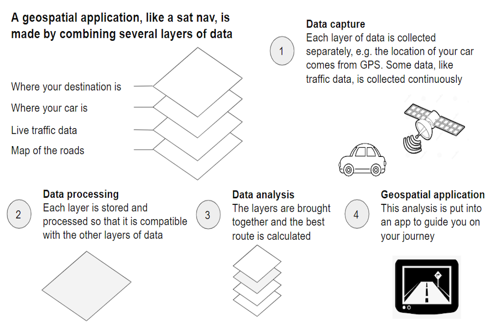
Figure 1: Example of how a geospatial application is built
Enabling technologies are driving change in the geospatial ecosystem
The infographic above illustrates how a geospatial application might be built. Each stage in this process is enabled by technology. For example, sensors in your phone or car combine with satellite technology to capture the location of your vehicle.
Many assessments of future trends emphasise the pace of change in the evolution of these enabling technologies [footnote 22]. This was reflected in responses to the Geospatial Commission’s 2022 Call for Evidence, which also highlighted how it is driving a transformation of the geospatial ecosystem as a whole. Digital technology has been a key driver of competition in sectors across the economy: enabling efficiencies and unlocking innovation that has disrupted markets, from digital banking to film and television streaming services.
Impacts of enabling technology on the geospatial ecosystem
Data capture
The availability of smaller, cheaper sensors is creating new datasets with location attributes and enabling real time insights - from phones, watches and many other devices. Among other things this has driven an increase in the availability of population movement data. There has been a rapid increase in the number of commercial satellites, leading to explosive growth in the availability of more comprehensive, more detailed, more current and cheaper earth observation data.
Data processing
Cloud service providers are enabling this data to be stored off-site and processed remotely. This is democratising access to massive processing capability, which is needed for many geospatial datasets, such as satellite imagery and high volume Internet of Things data. Cloud platforms also allow data providers to create simple user interfaces so that location data can be analysed without it having to be downloaded, including by less technical users.
Data analysis
AI is enabling advanced analysis of location data through machine learning (ML), to help us identify issues in the natural and built environment. It is also enabling the mapping of cities in new and innovative ways [footnote 23].
These changes are creating new opportunities for geospatial applications, such as climate change forecasting where data analysis that was previously too time-consuming and expensive is now achievable through a combination of supercomputing capability, cloud and AI. The particular importance of enabling technologies that improve processing and analysis of the vast amounts of data now available is reflected in the responses to the Geospatial Commission’s Call for Evidence.
Demand for location services is increasing but there remain challenges around awareness of geospatial among different sectors of the economy
Consumer, public sector and corporate demands for geospatial applications and services have all grown significantly as societies adapt to a digital economy where technology is a part of everyday life. Compared with five years ago, consumers now expect to see location data integrated into everyday applications, such as the ability to track a food delivery from the store to the front door.
Public bodies and private sector organisations are increasingly making use of cheaper access to high quality data and improved processing capability to open up new opportunities for efficiency and innovation. Detailed datasets, such as those covering population movements, can deliver valuable intelligence with wide-ranging benefits, from retail insights around footfall in a shop,to anticipating demand for a train line or a hospital. This demand will only increase further.
However, there is further to go to realise the benefits of location data. Responses to our Call for Evidence indicated that a lack of awareness about the benefits is still perceived as a barrier to adoption in some organisations and sectors.
Where organisations do not recognise how they can use location data, they may be unable to clearly articulate their demand. This means that geospatial services can be undervalued, underinvested in and underused.
To unlock the power of location data across our economy and society, we must increase awareness and understanding about its use and benefits. This will allow organisations to take advantage of the huge breadth of opportunities it offers.
UK Geospatial Strategy 2030
The UK’s Geospatial Strategy 2020 publication set in motion the coordinated delivery of many high impact projects and programmes. It acted as a foundational convening document for UK geospatial priorities and opened up the conversation around the key opportunity areas. We will build on activity delivered to date, from the next stages of the National Underground Asset Register (NUAR) to embedding FAIR (findability, accessibility, interoperability and reusability) data principles into data improvement programmes across the geospatial ecosystem.
This updated strategy will ensure the UK is in a strong strategic position to capitalise on the latest geospatial opportunities presented by the rapidly developing technological revolution. It recognises the important role that enabling technologies such as AI, cloud computing and sensors will all play in driving innovation in location insights and services. It also recognises that to grasp the opportunity presented by location data, we need to increase awareness and uptake of geospatial services across the UK economy.
The refreshed strategy updates the UK missions to reflect the changes that are happening in the geospatial ecosystem. The three missions detailed in section 3 will ensure that the UK remains at the forefront of geospatial innovation globally and maximises the value of location data and services:
- Mission 1: Embrace enabling technologies to accelerate geospatial innovation
- Mission 2: Drive greater use of geospatial applications and insights across the economy
- Mission 3: Build confidence in the future geospatial ecosystem
As the UK seeks to benefit from new technologies, this strategy reflects how location data will continue to unlock progress across the UK and globally. Location insights and services will help businesses to compete, deliver better public services, improve the lives of individuals, and conserve the environment. We will continue to use the nine opportunity areas to demonstrate the impact of location data across the economy.
The context in which we operate will continue to evolve rapidly. With this in mind, we will keep the strategy under review to ensure that it remains current, reflecting the priority challenges faced by the geospatial ecosystem and the approaches we advocate to meet them. Each year we will publish an annual plan outlining key actions that the Geospatial Commission will take in the year ahead.
UK Geospatial Strategy 2030
Sits with the science and tech policy agenda:
AI
Space
Data
Technology
Digital Infrastructure
Telecoms
Supports policy areas across government:
Environment
Property
Levelling up
Transport
Defence
Emergency Services
Energy
Agriculture
Business and Trade
Health and Social Care
UK geospatial strategy delivery to date
- February 2018: Geospatial Commission established
- February 2018: Government Geography Profession established
- August 2018: ‘National Geospatial Strategy: Call for Evidence’ published
- April 2019: National Underground Asset Register pilot phase launched
- April 2020: Public Sector Geospatial Agreement launched
- April 2020: Royal Mail Postcode Address File Public Sector License started
- June 2020: ‘UK’s Geospatial Strategy 2020-2025’ published
- July 2020: Aerial Photography Great Britain contract started
- November 2020: ‘Enhancing the UK’s Geospatial Ecosystem’ report published
- January 2021: Transport Location Data Competition phase 1 launched
- March 2021: Location Data Scotland pilot launched
- March 2021: ‘Planning and Housing Landscape Review’ published
- March 2021: ‘Digital strategy for Wales’ published by Welsh Government
- May 2021: ‘Mapping the Species Data Pathway: Connecting species data flows in England’ report published
- August 2021: ‘Positioning the UK in the fast lane: location data opportunity for better UK’ report published
- August 2021: National Land Data Programme launched
- August 2021:Transport Location Data Competition phase 2 launched
- October 2021: ‘Scottish Space Strategy’ published by Scottish Government
-
November 2021: COP26 events:
- Meeting Net Zero with the power of place: Space and Geospatial Virtual Pavilion events for COP26 (with Knowledge Transfer Network, British Geological Survey, Coal Authority, Ordnance Survey, UK Hydrographic Office and other partners)
- Applying climate and location data to better understand climate impacts and make informed decisions (with Costain, Esri UK, Met Office, Ordnance Survey, World Meteorological Organization and Costa Rican government)
- December 2021: ‘Public dialogue on location data ethics: engagement’ report published
- February 2022: ‘How FAIR are the UK’s national geospatial data assets? An assessment of the UK’s National geospatial data assets’ report published
- April 2022: Ordnance Survey’s quadrennial Cambridge Conference
- May 2022: ‘UK Geospatial Data Standards Register’ published
- June 2022: ‘Demand for geospatial skills’ report published
- June 2022: ‘Investigating UK public sector demand for Earth Observation technology’ report published
- June 2022:‘Building public confidence in location data: The ABC of ethical use’ report published
- August 2022: ‘Measuring the economic, social and environmental value of public sector location data’ guidance published
- November 2022: ‘Call for Evidence: Geospatial opportunities across the economy’ published
- December 2022: ‘Getting to the point: accelerating EV chargepoint rollout through geospatial data’ report published
- December 2022: 1.5 million individual local land charges migrated in total to the new register by HM Land Registry
- February 2023: ‘A pathway to decarbonised growth: using data to lead development’ report published by Connected Places Catapult and Department for Transport
- March 2023: National Underground Asset Register minimum viable product launched
- March 2023: ‘Transport Data Strategy’ published by Department for Transport
- March 2023: ‘Local authority transport: understand data sharing’ guidance published by Department for Transport
- March 2023: ‘Towards a digital twin for urban transport’ report published by Department for Transport
- March 2023: Data, digital, diversity training skills pilot launched
- March 2023: Find transport data beta launched by Department for Transport
- April 2023: Earth Observation Symposium (co-hosted with ONS Data Science Campus and Satellite Applications Catapult) to launch commercial EO data pilot for 35 public sector bodies
- May 2023: ‘Finding common ground: Integrating data, science and innovation for better use of land’ report published
Our six partner bodies will play a key role in delivering this strategy
As seen throughout this document, we work with a wide variety of public sector organisations, from government departments to the Office for National Statistics and the Met Office as well as agencies in the devolved administrations, such as Ordnance Survey Northern Ireland and Registers of Scotland.
Formally, we are connected to the Geospatial Commission’s six partner bodies, also known as the Geo6. These organisations are the custodians of data that underpins key elements of the UK’s geography: our land, our geology, our waters and our buildings. This data is a foundational resource for the UK’s geospatial ecosystem, allowing others to provide services and maps in areas like navigation, property, international shipping and construction.
These organisations have a collective 870 years of geospatial experience and have helped to shape the UK into becoming a world leader in geospatial capability. Their expertise is recognised both nationally and internationally, and their services are exported around the world.
The partner bodies continue to work together to improve the standard and quality of the UK’s public sector geospatial data foundation, on topics such as data interoperability, governance and common standards. This work links with global best practice on geospatial and statistics, including the UN-GGIM’s Integrated Geospatial Information Framework (IGIF).
If the UK is to maintain its position as a world leader we must be ambitious and bold in our adoption of emerging technologies and invest in innovation. Our partner bodies have a role in understanding and meeting this challenge, and have already taken action to update their services, drive innovation and explore the use of cutting edge technologies. A few examples include:
British Geological Survey (BGS)
The BGS, in collaboration with Ordnance Survey, received funding to explore and gather evidence regarding the desirability and usability of key BGS data assets being served up through the OS Data Hub. Driven by stakeholder engagement and desire to broaden awareness and reach of BGS data, work has explored findability and accessibility within an expanded cross-agency centralised distribution platform.
Coal Authority
The Coal Authority is working with Ordnance Survey to combine data from both organisations with other national datasets, such as heating and cooling demand, waste heat sources and heat networks. This will give us a better understanding of where mine water technology may be deployed, delivering a low carbon solution for space heating and hot water.
HM Land Registry (HMLR)
HMLR is working in partnership with local authorities in England and Wales to standardise and migrate local land charges information to a new geospatial digital register. Local land charges are restrictions or obligations on land, such as conditional planning consents, Tree Preservation Orders and listed building status.
HMLR is using AI to automatically extract local land charges from over two million scanned local authority documents, enabling the programme to deliver faster and more efficiently. HMLR is also investigating the use of AI to validate Tree Preservation Order data by automatically identifying trees in aerial imagery.
Ordnance Survey (OS)
OS has worked with the National Centre for Earth Observation to deliver heat maps of the UK to show our temperature in far greater detail than previously possible. Making use of thermal imagery from satellites, the heat maps help us identify which areas are facing heat stress. By providing accurate heat maps, the project helps us manage the local impacts of temperature increases in the UK.
UK Hydrographic Office (UKHO)
Mapping sea beds is a technically difficult process and the data produced through bathymetric surveys requires validation by experienced workers. The UKHO has developed an AI tool, called ADMIRALTY GAM, which is able to classify and remove noise from these surveys which substantially improves the volume and velocity at which the data is refined.
Valuation Office Agency (VOA)
The Geospatial Commission has worked with the VOA to broaden access to VOA property attribute data. Expanding access to property attribute data held by the VOA will support economic growth, delivery of better infrastructure and essential government functions.
For example, it will aid flood response by identifying sub-surface households, improving response priorities; enable insurance companies to provide more competitive quotes; and allow the energy sector to develop higher efficiency heating systems in support of net zero. In 2021, the government committed to legislation supporting access to VOA data as part of the Brexit opportunities: regulatory reform announcement.
These and other innovations will help to develop our national capability and maintain the UK’s world leading position. As organisations that have and will continue to drive global innovation, we recognise the fundamental role our partner bodies will continue to play in the future geospatial ecosystem.
Spotlight on: Geovation
Geovation is an Ordnance Survey initiative focusing on enabling innovation using geolocation data. It sits at the heart of the geospatial ecosystem, connecting industry challenges with startup solutions.
Together with HMLR, over the last five years, Geovation has built an award-winning Accelerator Programme which has so far kickstarted the business of over 150 geospatial and property startups who have collectively raised more than £170 million in funding to date and created over 2,500 jobs for the UK economy.
In addition, in partnership with Registers of Scotland, Geovation Scotland is amplifying our support for open innovation and collaboration across Scotland’s location and property sectors. More recently, it has partnered with UKHO to deliver an innovation challenge focusing on how to identify diffuse coastal pollution.
This year, Geovation has launched the International Geospatial Innovation Awards, celebrating how innovation using location data improves the world, while positioning the UK as the authoritative centre of expertise for geospatial innovation.
Section 3: Unlocking the power of location
These updated missions represent a targeted approach for unlocking the power of location towards 2030. The actions outlined are not comprehensive.
They build on activity to date, developing existing programmes further, as well as setting an intention to explore new opportunities. These are the next steps in the direction of travel set out in this strategy, with the opportunity to scale as we build evidence to support further investment.
Mission 1: Embrace enabling technologies to accelerate geospatial innovation
Mission overview
The geospatial ecosystem is being transformed by the rapid pace of innovation in key technologies. Location data capture is being revolutionised by advances in sensor technology and earth observation (EO) capabilities. Cloud technology and advanced computing are transforming the potential for data storage and processing. AI, machine learning and augmented reality are opening up new ways to analyse and visualise data. The integration of these technologies with the support of improved data standards will enable the power of location to be unlocked.
The geospatial ecosystem needs to embrace emerging technologies if the UK is to remain at the forefront of geospatial innovation. This will require effective partnerships across academia, industry and the public sector, to focus on research and development, and the fostering of innovation from seed to scale-up and implementation.
The Geospatial Commission is focused on supporting innovation and driving growth across the geospatial ecosystem with initial targeted initiatives on remote sensing and population movement data.
Market intelligence and other enabling technologies
New technologies with the potential to enable innovation across the geospatial ecosystem are regularly emerging. Increased processing capability from high performance computing and advances in cloud computing are improving the modelling of local and global systems, giving us greater power to forecast the impacts of climate change and extreme weather conditions.
Generative AI, such as large language models, is opening the door to new ways of understanding and querying very large amounts of information, including location data. These advances will continue to revolutionise our understanding of the world around us.
Understanding the geospatial ecosystem and how it is changing will enable us to clearly articulate its value, highlight important opportunities, anticipate and manage risks and residual barriers, and better target public sector funding for geospatial innovation.
Over the coming years, we will continue to build our understanding of the geospatial ecosystem, providing an informed view of the potential impacts of disruptive technologies, and outlining the opportunities and risks that they present
We will work with public sector partners, such as UKRI, to drive coordination and direction in public sector funding for geospatial research and development
Case study: Artificial intelligence for flood detection in the UK
As a consequence of global climate change, the UK will face more days of heavy rainfall and more flooding. Mapping the risks of flooding requires the analysis of massive datasets. This has previously involved a time- consuming and semi-manual process.
Through the Hartree National Centre for Data Innovation (HNCDI) and the Science and Technology Facilities Council (STFC), HNCDI teamed up with IBM to develop a machine learning algorithm capable of identifying past and current flood events using satellite data.
The team trained the algorithm using open-access EO data that accurately detailed previous flood events. Then they used advanced deep learning techniques to develop a Convolutional Neural Network (CNN) to perform object detection. CNNs are a type of AI particularly suited to image analysis, and therefore to applications involving EO data.
The algorithm’s capability was verified against a set of other known flood events. Now operational, it has significantly accelerated the process of identifying and labelling flood event data.
The labelled data is hosted on a geospatial cloud platform, also developed through HNCDI called Geospatial Discovery Network (GeoDN), and is fed into a suite of related HNCDI modules to predict areas at high risk of flooding and to help inform decisions around infrastructure development, maintenance plans or crisis management.
Remote sensing
The UK has a vibrant remote sensing and EO market. The number of EO satellites and sensors have increased significantly in recent years and the technology itself has advanced. Figures in The 2022 Size & Health of the UK Space Industry report show that EO technology supported an estimated £106 billion of UK GDP (5.1%).
Sensors attached to different remote platforms, such as aerial, drone and ground-based, and covering a range of spectra such as optical, radar and thermal, are bringing new insights and potential across a range of use cases. The UK must continue to develop its capability to acquire, process and analyse data derived from innovative remote sensing technology.
In November 2022, the government announced up to £200 million of investment in the UK EO sector to protect UK talent and industry.[footnote 24]The National Space Strategy (NSS) includes an ambition to ‘remain at the forefront of EO technology and know-how’ and national priorities for civil EO are being developed to focus activity to achieve this ambition. These priorities build on the strengths of our world-leading sector and set out the ambitious, sector-specific outcomes that will deliver UK EO sector growth and innovation.
In June 2022, the Geospatial Commission co-published with the Satellite Applications Catapult, the Investigating UK public sector demand for Earth Observation technology. In this report, the Satellite Applications Catapult identified 125 current and emerging use cases for satellite data across the public sector and identified the main barriers to EO maturity and increased uptake of satellite EO data in the public sector.
For example, Northern Ireland is working to leverage space-based EO data in the public sector to support emergency preparedness and response, as well as undertaking work funded by the UK Space Agency to develop a public sector portal centralising EO data and resources.
In spring 2023, the Geospatial Commission initiated a commercial EO pilot to test ways that the public sector can efficiently access data derived from innovative EO technology to improve public services. Eligible UK public sector bodies are able to test the use of data and access services within priority policy areas until the pilot ends in March 2024. The findings of this pilot will contribute to the Department for Science, Innovation and Technology’s (DSIT) wider programme to develop a roadmap for new civil national EO capability priorities.
We intend to further develop our understanding and measurement of the integral role that EO data plays in the UK economy.
By autumn 2024, following the conclusion of the EO pilot, we will publish key findings covering how the public sector’s access to and innovative use of EO data can be supported
By the end of 2024 we will conduct a review of the remote sensing market, including a review of the existing collective procurement of aerial photography for the public sector, with a view to exploring future access models
Spotlight on: Earth observation (EO)
There has been huge growth in the EO sector over the last decade, in line with the exponential increase in government and commercial satellite launches around the world. In 2022, there were an estimated total of 6,905 active satellites orbiting the Earth compared with 1,091 in 2012.
In the past the satellite imagery sector used mainly large, complicated and costly satellites, but global cross-sector development in space launch, satellite and sensing technologies has created opportunities to use smaller satellites at a fraction of the cost. For example, CubeSats often weigh no more than 2kg each and can be launched in groups that form large constellations, generating huge volumes of valuable EO data.
As of January 2023, there are more than 150 commercial and public satellite constellations in orbit with EO sensors. The increase in EO satellite launch and capability will continue as more sensing technologies are commercialised such as thermal imaging and video, and with increasing demand for near-real-time and granular insights.
Cloud and data infrastructure technologies are critical for processing the huge volumes of EO data collected by satellites in orbit. Initially EO insights could only be generated by highly specialised organisations, but there has been a significant increase in parts of the location data market reducing barriers to access through the processing and analysis of the data in combination with other sources of location data and remote sensing. Machine learning and AI are critical tools that are being harnessed to efficiently extract insights from the data, for example automated change detection used to monitor urban development.
Population movement data
Aggregated and anonymised population movement data from mobile phones, apps and other sensors is an emerging geospatial opportunity area. This type of data was used extensively to support the COVID-19 response and there is a growing market in the UK and globally. The Geospatial Data Market Study (2020) included a specific deep dive into mobile phone derived location data, identifying a huge range of established use cases in transport, marketing, statistics, utilities and healthcare and other potential future uses.
There are a growing number of companies that use aggregated population movement data to provide sector specific solutions, such as sphere of influence solutions using population movement data in the retail sector to analyse access to stores and services.
Demand for this data is also increasing within the public sector. The National Situation Centre has indicated that real-time aggregate population movement data is of use on over 40% of the risks in the National Security Risk Assessment and is a key factor in response planning for crisis events such as local flooding.
The Geospatial Commission has established a cross-government and devolved administrations steering group for population movement data. This group is supporting a deeper collective understanding of opportunities and barriers to accessing and using aggregated and anonymised data across the public sector.
By summer 2024 we will publish an assessment of the market for data about population movement, including its strategic importance, privacy and security implications, and use in the public sector
Case study: The Transport Location Data Competition
In 2021, in partnership with Innovate UK, the Geospatial Commission invested £5 million in innovative uses of location data through our Transport Location Data Competition. The 28 competition winners received funding to create geospatial solutions to our transport challenges.
One of the winners, Dynamon, developed a web-based data analytics tool called ZERO, which helps commercial transport companies optimise their transition to zero emission vehicle (ZEV) fleets. ZERO enables fleet teams to identify the optimum ZEVs and charging infrastructure based on their unique operation and depot electricity constraints.
ZERO works by combining geospatial datasets (fleet telematics data, terrain data, weather data, traffic data, chargepoint data) with ZEV performance data obtained from Dynamon’s ZEV testing program. ZERO can forecast real-world ZEV performance within specific fleet operations and identify the required charging infrastructure to ensure a ZEV fleet can perform the same operation as a previous internal combustion engine fleet.
Dynamon has identified 4.9 million kilometres driven each day by large fleets that could transition to zero emission vehicles. By using ZERO, fleets can identify the optimum ZEVs for their operations whilst minimising cost.
Mission 2: Drive greater use of geospatial applications and insights across the economy
Mission overview
A lack of awareness is limiting the use of geospatial applications across many areas of the economy, despite huge opportunities. If the UK is to continue to develop its thriving market for geospatial applications and improve public and consumer services, we need to build greater understanding of the opportunities across the economy, including in the nine opportunity areas.
The Geospatial Commission utilises high value geospatial applications to capture the imagination and demonstrate tangible impacts, such as the National Underground Asset Register (NUAR). These applications can be used to drive engagement in parts of the economy where there is significant geospatial opportunity but low awareness. The Geospatial Commission’s projects will continue to target areas where there is a clear opportunity to increase maturity in the use of location data, including infrastructure, land use, targeted sectors and the wider public sector.
Underground infrastructure
Each year in the UK, around four million holes are dug to install, operate, maintain and repair the pipes and wires buried underground - assets that are critical for keeping the water running, gas and electricity flowing and our telecommunications lines connected.
Approximately one in every 65 holes dug results in accidental damage to buried infrastructure (some 60,000 a year). This equates to a cost of around £2.4 billion to UK businesses and the wider economy. Risks include: digging through live cables and pipes, posing a risk to life; unnecessary project delays from finding unknown buried infrastructure; accidental damage to pipes and cables; and streets and roads being closed for longer causing traffic congestion that affects local economies and residents.[footnote 25]
This problem would be easier to avoid with better information about the location of buried assets. However, this information is held by over 700 different organisations across the UK and assets have been buried over hundreds of years with varying degrees of record-keeping. Although asset owners are required to make their data available to companies or agencies undertaking work around the highway network free of charge, obtaining it requires contacting multiple sources, with the data provided in different formats, scales and to varying timeframes.
This is the challenge that VAULT addresses in Scotland, and NUAR aims to solve in England, Wales and Northern Ireland. NUAR is a government-led programme aimed at more efficient information exchange by creating a data-sharing platform on the location and condition of underground assets. It will be a secure data-sharing service that will provide an interactive, standardised digital view of the underground assets in a given location.
The fundamental purpose of NUAR is to streamline the data-sharing process, reduce the risk of potentially lethal utility asset strikes and promote more efficient management and maintenance of underground assets. Once operational, NUAR is expected to deliver at least £350 million per year in benefits by avoiding accidental asset strikes, improving the efficiency of works and enabling better data sharing.[footnote 26]
In spring 2023 the Geospatial Commission launched its minimum viable product for NUAR in North East England, Wales and London. This includes data from energy, water and telecommunication companies, local authorities and other public sector bodies.
By spring 2024 we will roll out the current, minimum viable product version of NUAR beyond North East England, Wales and London to the remaining regions in England and Northern Ireland
By the end of 2025 NUAR will be fully operational
Case study: The National Situation Centre
The National Situation Centre (SitCen) was established in 2021 to bring timely data, analysis and insights from across and beyond government to support crisis response and national security. It draws on lessons learned from the COVID-19 pandemic. It has supported the government’s response to Russia’s invasion of Ukraine, extreme heat and industrial action. It routinely monitors 160 key performance indicators across 10 thematic areas.
Strengthening government’s crisis-related data holdings is a standing objective for SitCen. Its officials work with their counterparts in other government departments to ensure data, analysis and expertise required for crisis response is strengthened across government as a whole. SitCen uses the National Strategic Risk Assessment (NSRA) to identify and prioritise the data it needs.
SitCen has used location data to support a number of responses, including Storm Eunice and the State Funeral of Her Majesty The Queen. SitCen has used geospatial datasets, from both OFFICIAL and commercial sources, and drawn on Ordnance Survey’s support, to show how events are unfolding in near real time in local areas, ensuring that ministers have the best possible data for decision making.
Land use
Land is a fundamental resource for human existence. It provides food, clean air, fresh water, shelter and the minerals and space required to produce all manufactured goods and technologies. Land use is influenced by human decision making and biophysical processes - from the emergence of farming 12,000 years ago to today’s debates over solar farms, high-speed rail or housing developments - and is interwoven with our sense of place, identity and culture.
The UK’s ambitions to deliver economic growth, level up communities and meet the demands of a growing population, while protecting the environment, adapting to climate risks and reaching net zero will require significant land use change in the coming decades. Complex decisions will need to be taken about how best to use the UK’s land, given that it is a finite resource which faces increasing demands.
Decisions about land use must take account of spatial information: environmental factors like wind and temperature; features of the terrain like soil conditions and whether the land is flat or mountainous; information about nearby infrastructure like roads and electricity; and information about natural habitats, such as peatlands or ancient woodlands.
Bringing together spatial information in an accessible way can help public authorities, businesses and individuals to consider the spatial and system-wide impacts of land use change in order to manage trade-offs and avoid unintended consequences.
The Geospatial Commission has been delivering the National Land Data Programme (NLDP) to demonstrate where innovative spatial data, analysis and evidence can support better land use decisions at national, regional and local scales. In May 2023, we published our report Finding common ground: Integrating data, science and innovation for better use of land. This report set out the key findings from the NLDP and made recommendations for how the UK’s spatial data capabilities can be enhanced to support land use decision making at a range of spatial scales.
In the report we committed that over the coming years we will go further in driving improvements in land use decision making capability:
By the end of 2024 we will explore the creation of a Land Use Analysis Taskforce, which will bring together, through appropriate new cross-departmental governance, a shared spatial analysis capability to provide a spatially-explicit evidence base that will help inform the delivery of key national priorities
The report also sets our intention to champion market innovations that help visualise and deliver how we can achieve better land use decisions; strengthen the links between land use policy design, academic research and industry practice; and develop a standard approach to classifying key land use data to improve how we can link data about land.
Case study: Living Wales
Living Wales is a world-first programme that aims to capture the state and dynamics of Wales’s landscape, in near real time, historically and into the future. It does this by making use of key technologies including earth observation (EO) data, high performance computing and advanced data architectures.
This programme, led by Aberystwyth University (Prifysgol Aberystwyth), is working with existing initiatives to collate, process, analyse and make publicly available the vast archive of satellite imagery over Wales to address key issues for the Welsh economy, policy and populations. The research component focuses on:
- The implementation of algorithms to interrogate EO data (including the European Copernicus Sentinels and NASA’s Landsat) to drive insights about agriculture, forestry, water and urban areas
- The provision of quantitative biophysical data (e.g. on vegetation and hydrology) for assessing trends attributed to climate or other environmental change
- The routine production of detailed and high-resolution land cover and habitat classifications across Wales
- Identification of options for optimising land use, and conserving and restoring landscapes and ecosystems
Living Wales is enabled by the use of emerging technologies. Its EO data includes imagery captured by CubeSats and drones using LiDAR, hyperspectral and thermal imagery. Processing this volume data requires a huge amount of computing power, which is supported by Supercomputing Wales who provide scientists and industry with access to high performance computing facilities, as well as commercial cloud providers. Critically, a data cube architecture has allowed a high-density time series of data to be interrogated efficiently to minimise processing demands and maximise the speed at which insights can be generated.
By making use of key emerging technologies, Living Wales is delivering critical insights for businesses, policymakers and the general public.
Targeted sectors
Transport
The movement of goods and people is inherently spatial and the transport sector lends itself to geospatial applications. This is true across all modes of transport - walking, cycling, road, rail, air or sea. Location data can drive efficiencies and safety benefits in transport, for example by installing monitoring sensors on trains to identify track faults earlier or by enabling more efficient and optimal vehicle routing, saving time, fuel and costs.
The opportunities for advanced geospatial applications in transport are increasing. For example, data from satellite navigation applications can be aggregated by providers to understand live traffic patterns and data generated by sensors and connected vehicles has realisable public benefits, such as helping to plan, monitor and maintain road networks.
The adoption of these applications is being driven by the need to decarbonise our transport system to meet our net zero commitments. This will require infrastructure upgrades, from provision of a comprehensive electric vehicle charging infrastructure to optimisation of our transport networks to enable more active travel.
The Geospatial Commission has already made progress in the transport sector. In 2021, in partnership with Innovate UK, we invested £5 million in innovative uses of location data through our Transport Location Data Competition. The experiences of the innovators funded by the competition provided first hand insight into how transport challenges and opportunities may be navigated as well as informing the appropriate role for government in this sector.
In 2021, the Geospatial Commission identified opportunities for location data in the report Positioning the UK in the Fast Lane. One of the opportunities identified in this report was for location data to support the rollout of chargepoints for electric vehicles. In 2022, we published Getting to the point, which set out an action plan to establish how location data can help deliver the chargepoint network needed by 2030.
The Geospatial Commission will work with partners across the public sector to support the adoption of geospatial technologies to enable the transition to a greener, safer and more efficient transport system, and monitor how geospatial applications can drive innovation in the sector.
By summer 2023 we will publish findings on how geospatial applications can enable the delivery of connected and automated mobility.
By autumn 2023 we will share our findings for the public sector to make more informed decisions about electric vehicle chargepoint locations, as set out in our report Getting to the point.
Property
Applying a spatial lens is essential for a well functioning property sector, from town planning and site identification to property management and retrofitting. The property sector is rapidly adopting new technologies and becoming increasingly digital. Location data, services and technologies are central to this technological revolution. The achievement of the sector’s economic, environmental and social goals, from boosting productivity and innovation to improving our residential areas and achieving net zero commitments, rely on accessible location data and innovative location services.
The Geospatial Commission has already made progress in this sector. We worked with GeoPlace, the Local Government Association, the Improvement Service and Ordnance Survey to provide access to Unique Property Reference Numbers (UPRNs) and Unique Street Reference Numbers (USRNs) free of charge under an Open Government Licence, as part of the Public Sector Geospatial Agreement (PSGA) held between the Geospatial Commission and Ordnance Survey.
UPRNs and USRNs provide every property and street with a consistent identifier throughout its lifecycle, from planning through to demolition. This enables certainty when identifying buildings, and effective machine linking and matching of data, bringing huge efficiencies.[footnote 27]
Alongside our partner bodies, we have been working closely with industry, academia and the public sector over the last year to understand further opportunities.
By summer 2023 we will publish our findings on opportunities to unlock greater value across the property ecosystem through location data, technologies and services
Health and wellbeing
Location data technology is already enabling the spatial representation of data to support better health planning and decision making. The pandemic saw high profile applications of where location data was used to understand the spread of COVID-19 and inform vaccine rollout. The need to reduce pressure on acute care settings creates opportunities for technology to help with remote-based or autonomous care in community or at-home settings. The expansion of fitness trackers also creates new opportunities for greater population-level insight.
By the end of 2024 we will publish a report identifying the cross-cutting challenges and opportunities for location data in the health sector
The geospatial community
The delivery of this strategy relies on the UK’s talented workforce and the energy and enthusiasm of the geospatial community. You can contribute in a variety of ways.
If you have relevant technical expertise, whether you are in academia, business or the public sector, you can help the UK to build new geospatial applications. By looking ahead you can support the adoption of cutting edge technologies and keep the UK at the forefront of global innovation.
If you work in an organisation or a sector with lower awareness of geospatial, you can be an advocate and build awareness of the value geospatial applications can bring. You can help to build the case for investment using tools, such as the Geospatial Commission’s guidance on Measuring the Economic, Social and Environmental value of public sector location data.
If you are a student in science, technology, engineering and mathematics (STEM) subjects, such as geography, data science, physics and engineering, you are perfectly placed to build your own awareness and skills around the use of location data. As you look to develop your career you can consider roles that will support the UK’s geospatial capability and help us to tackle important challenges, such as climate change forecasting, understanding and managing trade offs in land use, the design of our infrastructure and transport systems, and the delivery of emergency services.
All of us can help to identify examples of geospatial applications that are inspiring and where the application and impact can be communicated in plain language. Sharing such examples with us and with each other can help us all to build a more compelling narrative to explain the value of geospatial.
Public sector
Location data, services and applications are at the heart of public services at every level of government, supporting service delivery where it is needed, driving more efficient use of public money and supporting effective policy-making.
The Geospatial Commission engages widely with colleagues across devolved administrations, government departments, arms length bodies and local governments to embed geospatial capabilities to improve public services.
Access to location data and services
The Geospatial Commission manages cross-government contracts to support access to key geospatial datasets for the public sector. This includes Ordnance Survey data, address data and aerial photography. Collectively, these agreements support the provision of data for over 5,500 organisations across the public sector[footnote 28], from central government to the emergency services, local authorities and town councils. The data is used to support the day-to-day management of public services as well as building environmental resilience and planning new infrastructure.
By spring 2024 we will conduct a review of the PSGA to ensure it remains fit for purpose over the remaining seven years of the agreement, including an evaluation of: the data and services included in the agreement; its delivery model; and the foundations users have in place to make effective use of data provided under the agreement
In 2021, working with the Crown Commercial Service (CCS), the Geospatial Commission launched the Space-Enabled and Geospatial Dynamic Purchasing System (SEGS DPS), a procurement framework aimed at the geospatial ecosystem that will make it easier for the public sector to buy geospatial services. We will continue to promote and advocate this system as a procurement vehicle for the public sector to access new and emerging geospatial technologies and to wider industry and innovators as a route to market.
The geography of work
There has been a fundamental change in where and how people work following the COVID-19 pandemic. These changes include an increase in ‘hybrid’ work and entirely remote working; ‘anywhere’ jobs now account for one in five jobs in the UK.[footnote 29]
The binds that previously tied a job to a specific geography have been loosened and this has an impact on how our society operates via use of transport, occupation of cities and housing and cultural participation. We will undertake research to understand how and why this is changing so that we can advise on improved place-based policy making.
By summer 2024 we will undertake new research, with partners such as Office for National Statistics, to understand the implications of geographic changes to where people work and land used for employment
Government Geography Profession (GGP)
The GGP is the government’s network to support geographical expertise, providing access for its 1500+ members to training, networking and relevant events, including through links to Royal Geographical Society (with the Institute of British Geographers) and the British Cartographic Society. It sits within the wider Government Analysis Function and has an important role to enhance geospatial skills, capabilities and awareness throughout the public sector with an aim to: standardise and professionalise geography as a public sector skill, consider how to improve analytics and data skills among its members, and champion the use of geospatial as a tool to support better policy creation and service delivery within and beyond its membership.
The GGP was established in 2018, with a vision to create and grow a high-profile, proud and effective geography profession that attracts fresh talent and has a secure place at the heart of decision making. Its 1500+ members work in roles across the public sector which includes central government, their agencies and local government to promote better use of geography in government, and to support the career aspirations and development priorities of geographers in the Civil Service and the wider public sector. The GGP has members involved in analytical, scientific, policy and operational delivery roles.
As one of the seven analytical professions within the Government Analysis Function, the GGP adds expertise in the multi-disciplinary approach needed by the Government Analysis Function to tackle the big issues faced by society.
The GGP helps to champion the value of location data through the celebration of the Geography in Government annual awards, which showcases the breadth of innovative uses of location data in areas such as policy development, operational delivery, emergency crisis and response and excellence in innovation in the public sector.
Previous award winners in 2021 include mapping the spread of COVID-19, ONS using traffic cameras to provide real time information about population movement, to the joint overall winners in 2022, Greater Manchester Combined Authority’s Digital Exclusion Risk Index project and Defra’s Spatial Data Science work, modelling the geography of land use change and its impacts. These demonstrate the value of geospatial data used by skilled practitioners to support policy goals.
Mission 3: Build confidence in the future geospatial ecosystem
Mission overview
Technological advances throughout the geospatial ecosystem have the potential to address key challenges across the economy, improving our society and protecting our environment. To unlock the full potential of geospatial applications and services, all parts of the ecosystem including the public need to have confidence in innovative geospatial applications.
Building on our work to date, the Geospatial Commission will continue to engage with partners both domestically and internationally to create an environment where ethical, privacy and security concerns are appropriately addressed. We will also continue to support addressing the emerging skills and capability demands across the geospatial ecosystem. We will aim to create an environment in which the geospatial ecosystem can flourish - both today and in the future.
International
To maintain the UK’s position as a science and technology superpower, we need to work in collaboration with international partners, learning from global best practices, to ensure location data is used as a force for good. Following on from international events, such as the Cambridge Conference, and geospatial showcases at other global gatherings, such as the UN Climate Change Conference of the Parties (COP26) in Glasgow, the UK will continue our collaborative leadership in the community of nations driving progress towards a strong, secure, effective and inclusive geospatial ecosystem.
With the support of partners across the public sector, this participation will take place via fora such as the United Nations Committee of Experts on Global Geospatial Information Management (UN-GGIM), including the UK’s co-chairing of the Integrated Geospatial Information Framework High Level Group’s communications workstream, and through continued support for the development of international standards that will support interoperability and innovation.
We will remain committed to the UN-GGIM, including through the UK’s engagement in meetings of the expert committee
The UK has an ambition to bring together partners and international stakeholders to consider the impact and emerging role of key technologies in the geospatial ecosystem and how we can build confidence in the future use of geospatial applications across all sectors.
In 2024 we will partner with UK stakeholders to deliver an international geospatial conference on the power of location
A strategic approach to data access
A strategic approach to sustainable data access, considering intellectual property, security and privacy, is crucial to building confidence and driving innovation and economic growth across the geospatial ecosystem.
A number of the Geospatial Commission’s projects have focused since on driving appropriate access to location data across the public and private sector. We have published guidance to support investment cases for improved access to geospatial data and technologies and developed FAIR principles to support appropriate access to location data held by public sector organisations.
The PSGA, alongside delivering access to public sector organisations, supports private sector access to Ordnance Survey data up to a threshold. The NUAR programme has at its core an aim to enable appropriate access to data relating to underground assets held in both the public and private sector, addressing commercial and security sensitivities.
In 2022 the Geospatial Commission published Building Public Confidence in Location Data: The ABC of Ethical Use. The paper outlines how to unlock value from location data while mitigating ethical and privacy risks, ensuring compliance with legal principles and retaining the trust of citizens. The paper was informed by a programme of engagement across the geospatial landscape, wider digital ethics policy and with the general public. In December 2021, the Geospatial Commission published findings of its independent public dialogue on location data ethics - the UK’s first deliberative consultation on location data ethics.
The ethics landscape is evolving with the emergence of new technologies and increasing use of datasets, such as population movement data. We will continue to monitor these developments and advise on how the ecosystem can continue to maximise confidence in the use of location data - for example through the use of privacy enhancing technologies.
We will continue to build on the experience from key Geospatial Commission projects to publish best practice on sustainable data access
Spotlight on: ‘Building Public Confidence in Location Data: The ABC of Ethical Use’
The Geospatial Commission’s public engagement found that many citizens recognise and support the use, sharing and reuse of their location data to provide personal conveniences and public benefits but that this support is conditional.
The paper we published in 2022 builds on work done by others around geospatial and broader data ethics. It provides organisations with three ethical building blocks - Accountability, Bias and Clarity (or ABC) - to build public trust and maximise confidence in this system of use and reuse of data, and as a result increase the public’s willingness to share their location data.
- Accountability: Governing location data responsibly, with the appropriate oversight and security
- Bias: Considering and mitigating different types of bias, and highlighting the positive benefits of location data
- Clarity: Being clear about how location data will be used and the rights of individuals
Skills
The UK cannot realise the value from geospatial applications without an appropriately skilled workforce that is positioned to develop and use new technologies. The pipeline of geospatial skilled individuals will depend on schools, further education and continuing professional development.
As the awareness of the value of location data grows, we anticipate the demand for these skills to increase, but we must also act to support appropriate capability and level of resource and ensure the UK is well placed to fully embrace the opportunity location data will bring to the UK economy.
In 2022, the Geospatial Commission published its report on the Demand for Geospatial Skills. Through the PSGA, we have overseen work by Ordnance Survey to improve outreach to schools and trainee teachers and fund geospatial PhDs.
We have supported the Centres for Doctoral Training led by Newcastle University and University of Nottingham. We have also supported the Trailblazer Group renewing existing geospatial apprenticeships and the Royal Geographical Society (RGS) in its work to establish a new masters level spatial modelling apprenticeship.
In Scotland, AGI Scotland is working in partnership with the University of Edinburgh, Location Data Scotland (a pilot funded by the Geospatial Commission), Scottish Government and Scottish Enterprise to understand the Scottish geospatial skills landscape across industry, academia and the public sector.
In March 2023, the Geospatial Commission, in partnership with the Government Geography Profession and Office for National Statistics (ONS) Data Science Campus, launched a pilot training programme to upskill public sector geographers from underrepresented backgrounds with digital and coding skills.[footnote 30] If the pilot is successful, we anticipate that this model could be used more widely in the public and private sectors to support growing the geospatial skills pipeline through continuous professional development.
By summer 2024 we will publish an assessment of the Data, Digital, Diversity Training pilot programme to review the value of this approach to upskilling geography professionals with digital skills
By summer 2024 we will work with universities to publish best practice as a first step towards embedding geospatial into data science and geography courses
We will continue to support the Government Geography Profession to improve geospatial capability throughout the public sector
Spotlight on universities and research centres
The UK has an active research and universities sector driving innovation through independent research and effective partnerships across academia, industry and the public sector. This is a remarkable asset in the form of a research base consistently ranked as world-leading in a wide range of areas.
The UK is home to four of the world’s top 10 universities: Oxford, Cambridge, University College London and Imperial College London, and 14 others in the top 100.[footnote 31] With less than 1% of the world’s population, the UK accounts for 4% of researchers, 7% of the world’s academic publications and 14% of the world’s most highly-cited academic publications.[footnote 32]
Innovation in geospatial and linking technologies is being driven by UK universities. A strong university research base is essential to developing a geospatial skills and innovation pipeline to industry application. As new technology transforms the economy and society, skills are in increasingly high demand across all sectors, as well as opportunities for new innovation and research. Much of this research will be critical to supporting real-world innovations in the coming years.
Below are some examples of universities which are trailblazers in driving research using location data with emerging technologies to bring geospatial data into the forefront of innovation.
The UK also has strength in our research organisations which include independent and non-profit organisations as well as Research Council Institutes. These include a vibrant mix of innovation institutions; Catapults; National Academies; Public Sector Research Establishments, such as the National Physics Laboratory and the Defence, Science and Technology Laboratory; Royce, Turing and Crick institutes.
The University of Southampton launched Southampton Geospatial in late 2022. It provides a unique collaboration hub for the University of Southampton’s interdisciplinary expertise in geospatial data science, putting together teams and projects to address the most important societal and environmental challenges by harnessing the power of geospatial data in the UK and globally.
To meet the skills gap in the Geospatial AI sector, Southampton Geospatial is also developing a range of postgraduate training programmes in Geospatial AI, which spans computer science engineering, geography, mathematical sciences and ocean and earth sciences. Current projects include working in partnership with the Dorset Coastal Forum capturing data to develop nature-based solutions for coastal protection and habitat conservation in the Studland Bay Marine Conservation Zone.
The University of Edinburgh is a well established leader in GIS studies and research. The university is fully embedded in the Scottish geospatial ecosystem, working in partnership with AGI Scotland, Location Data Scotland and other key public and private sector organisations, to understand the challenges of the geospatial skills landscape in Scotland. This partnership is working hard to broaden the available skills base.
Newcastle University and the University of Nottingham are in the fifth year of their Centres for Doctoral Training programme in Geospatial Systems. Since receiving funding from UKRI in 2019, they are well on the way to training over 50 PhD students.
Collaborating with more than 50 UK and global partners, the universities have developed a programme, which focuses on the geospatial skills that leading industry experts have deemed a priority, based on emerging technologies and global trends. Technical research themes include big data analytics, Internet of Things and AI, with application in domains ranging from smart cities and mobility to social inclusion and healthy living.
The University of Leeds spinout research digital twin company, Slingshot Simulations, located in Nexus, the university’s innovation community, recently secured a £3 million investment from Northern Gritstone (a collaboration between the universities of Leeds, Manchester and Sheffield to support the commercialisation of university spin outs in the north of England), Mercia and the Northern Powerhouse Investment Fund.
Slingshot Simulations provides a place-based decision intelligence software-as-a-service solution. It enables net zero, decarbonisation and climate resilience decision makers to rapidly connect policy to action by navigating and prioritising the vast range of available intervention options they have available.
-
NASA’s website to track the live location of the James Webb Satellite: Where is Webb ↩
-
Analysis based on data from Beauhurst on UK private companies ↩
-
Ordnance Survey (2022) Using AI to map African cities to improve infrastructure at low cost ↩
-
Google (2019) About Google Maps ↩
-
Railway Technology (2022) Rail station virtual tours: Improving safety and easing passenger nerves ↩
-
HM Treasury (2023) Pro-innovation Regulation of Technologies Review: Digital Technologies ↩
-
UK Government (2023) Integrated Review Refresh 2023: Responding to a more contested and volatile world ↩
-
UK Space Agency (2022) Size & Health of the UK Space Industry 2022 ↩
-
Some of which have since exited (through IPO or acquisition). ↩
-
Analysis based on data from Beauhurst on UK private companies ↩
-
World Intellectual Property Organisation (2022) Global Innovation Index 2022 What is the future of innovation-driven growth? ↩
-
UK Government (2023) Integrated Review Refresh 2023: Responding to a more contested and volatile world ↩
-
UK Government (2021) The Integrated Review 2021 ↩
-
Department for Digital, Culture, Media & Sport (2022) UK tech sector retains #1 spot in Europe and #3 in world as sector resilience brings continued growth ↩
-
UK Government (2022) National AI Strategy - AI Action Plan ↩
-
UK Government (2023) Integrated Review Refresh 2023: Responding to a more contested and volatile world ↩
-
Geospatial World (2022) GKI Phase 2 Report: Geospatial Knowledge Infrastructure Readiness Index and Value Proposition for World Economy, Society, and Environment ↩
-
UK Government (2021) The Integrated Review 2021 ↩
-
Analysis based on data from Beauhurst on UK private companies. ↩
-
Analysis based on data from Beauhurst on UK private companies. ↩
-
UK Government (2023) Integrated Review Refresh 2023: Responding to a more contested and volatile world ↩
-
Such as Gartner’s top ten strategic technology trends ↩
-
Ordnance Survey (2022) Using AI to map African cities to improve infrastructure at low cost ↩
-
UK Government (2022) Earth observation investment ↩
-
Geospatial Commission (2021) National Underground Asset Register (NUAR) - Economic Case Summary ↩
-
Geospatial Commission (2021) National Underground Asset Register (NUAR) - Economic Case Summary ↩
-
GeoPlace (2023) The power of the Unique Property Reference Number (UPRN) ↩
-
Ordnance Survey (2023) The Public Sector Geospatial Agreement: Providing the public sector access to our world-leading geospatial data ↩
-
Tony Blair Institute for Global Change (2021) Anywhere Jobs: Reshaping Geography Work ↩
-
Cabinet Office (2023) Apply now: New programme to improve digital and data skills ↩
-
QS: Top Universities (2020) World University Rankings ↩
-
Department for Business, Energy & Industrial Strategy (2019) International comparison of the UK research base, 2019 ↩