Getting to the Point: Accelerating EV chargepoint rollout through geospatial data
Published 20 December 2022

© Crown copyright 2022
This publication is licensed under the terms of the Open Government Licence v3.0 except where otherwise stated. To view this licence, visit nationalarchives.gov.uk/doc/open-government-licence/version/3 or write to the Information Policy Team, The National Archives, Kew, London TW9 4DU, or email: psi@nationalarchives.gov.uk.
Where we have identified any third party copyright information you will need to obtain permission from the copyright holders concerned.
This publication is available at https://www.gov.uk/government/publications/getting-to-the-point-accelerating-ev-chargepoint-rollout-through-geospatial-data/getting-to-the-point-accelerating-ev-chargepoint-rollout-through-geospatial-data
Ministerial foreword

Baroness Neville-Rolfe
The actions set out in this report will help local authorities and businesses to plan the rollout of electric vehicle (EV) chargepoints over the coming years. This is vital because the UK Government has set an ambitious agenda to decarbonise the entire transport system and put us firmly on a pathway to net zero by 2050. As part of this, by 2035 all new cars and vans will be required to have zero emissions at the tailpipe.
To make this transition, keep us on track, and provide the network our services and industries need, the UK must have an electric vehicle (EV) chargepoint network that works for everybody, everywhere. Location data is key to building the right infrastructure in the right places, giving confidence to the EV owners of today and tomorrow that they can efficiently reach their destination.
Location data can support faster chargepoint rollout, but barriers to its access remain. The private sector is leading the chargepoint rollout across the UK, but the public sector plays an important role in ensuring chargepoints serve everyone’s needs. Local authorities need the right data to understand how demand for chargepoints will evolve in local areas to guide delivery and factor this into wider infrastructure planning.
By getting the locations of these chargepoints right, we can build a chargepoint network that meets demand and removes the range anxiety sapping the confidence of many prospective EV owners. This report identifies how better use of location data can help overcome four key challenges to siting chargepoints as part of a coherent overall approach to chargepoint infrastructure planning.
I want to thank the Geospatial Commission, departmental colleagues, local authorities and industry for calling out the vital role that location data has to play. This work will support the government to realise our vision to build charging infrastructure at pace - and in the right places - to inspire confidence in greater adoption of electric vehicles.
Baroness Neville-Rolfe, DBE CMG
Minister of State, Cabinet Office
Executive Summary
The transport sector is undergoing an exciting transition to electric vehicles (EVs). The UK government has committed to ending the sale of new petrol and diesel cars and vans by 2030, and by 2035 all new cars and vans will be required to have zero emissions at the tailpipe.
This will require a comprehensive public EV chargepoint network. The UK government has set a vision for EV charging infrastructure that ‘works for everyone, wherever they live, work and travel’.
This is an enormous undertaking. The UK’s charging network must expand rapidly so that it is dependable, fair and covers the entire country. At least 300,000 public chargepoints will be needed by 2030, a significant increase from today’s total of around 35,000.
This is not just a numbers game - what matters is location. To build a chargepoint network that can work for everyone, chargepoints must be rolled out where they are needed for today and tomorrow.
Situating chargepoints in the right places ahead of demand will inspire confidence in drivers who have not yet made the switch, thereby accelerating the uptake of EVs, which in turn will stimulate economic growth and support decarbonisation. The electricity network is adapting to support net zero and chargepoint rollout is part of this.
Recent advances in spatial modelling and analytics offer immense opportunity to direct the efficient delivery of chargepoints. For example, we can now combine multiple datasets to understand chargepoint demand for a given area, pinpoint the most cost-effective locations and select which of these will best meet the needs of the community.
But such use of location data is currently the exception, not the rule. Modelling demand for chargepoints requires technical know-how and access to datasets about consumer preferences, shifting populations and the physical environment. The capability gap is particularly apparent among local authorities, which are fundamental to successful chargepoint rollout, particularly for the deployment of widespread on-street charging.
This report outlines four challenges to effective chargepoint rollout that location data can help overcome.
- Modelling future demand. Demand modelling can provide planners with data-driven evidence to identify how many and what types of chargepoints need to go where and by when, taking into account local needs.
- Finding suitable sites. Improved access to more granular data about energy capacity and physical constraints can support planners to identify the optimal locations and avoid wasted effort.
- Creating a seamless consumer experience. Making chargepoint location data more findable, accessible, interoperable and reusable (FAIR) will allow the private sector to create a better charging experience for EV drivers, while enabling more innovative products and services to develop.
- Tracking rollout. The government needs to ensure it can monitor rollout of chargepoints nationally and regionally by developing spatial metrics that can take account of local needs.
Location data can help deliver the public charging network needed to give drivers the confidence to switch to an EV, safe in the knowledge that they will be able to charge where and when they like.
Location data can help overcome four challenges to effective chargepoint rollout
Modelling future demand
Spatial demand modelling has the potential to provide planners with evidence on where to target chargepoint provision, down to the street-level.
| The Geospatial Commission will deliver a feasibility study into how to widen access to demand modelling, including whether existing models can be scaled up. | June 2023 |
| The Geospatial Commission will explore the creation of a geospatial dataset for off-street parking, considering existing sources of data and how to safeguard privacy. | June 2023 |
| The Geospatial Commission will examine how aggregated and anonymised mobility data could be applied to inform chargepoint rollout. | June 2023 |
Finding suitable sites
Location data can speed up site selection by understanding energy capacity, physical site constraints, hazards and opportunities on the kerbside.
| The Department for Business, Energy and Industrial Strategy (BEIS) is conducting a feasibility study to examine the needs case, benefits, scope and costs of an energy system ‘digital spine’ to support interoperability across the sector. | 2023 |
| The Geospatial Commission will deliver the National Underground Asset Register (NUAR). Once operational, planners will be able to consult NUAR in the planning, excavation and installation of new public charge points. | September 2024 |
Creating a seamless consumer experience
Innovative location data use can create a seamless charging experience that gives drivers confidence to switch to an EV.
| The government is legislating to mandate chargepoint operators (CPOs) to make data about their chargepoints available in a standard format. | Ongoing |
| As the government takes steps to make chargepoint data more Findable, Accessible, Interoperable and Reusable (FAIR), the Geospatial Commission will track how market innovators use the data to create new products and services which enhance the consumer experience. | Ongoing |
Tracking rollout
Spatially-informed metrics can support central government and local authorities to track where rollout is meeting demand for public chargepoints.
| Government will consider developing spatial metrics which use demand modelling to track regional disparities, while accounting for differences in local need. | Ongoing |
Introduction
Transport is the largest emitting sector of greenhouse gas emissions in the UK. Cars and vans were responsible for almost a fifth (19%) of the UK’s total domestic greenhouse gas emissions in 2019. Carbon-based transport depends on resources that may become scarcer. In 2020, the government announced that the UK will end the sale of new petrol and diesel cars and vans by 2030, with all new cars and vans being fully zero emission at the tailpipe from 2035.
The transition to zero emission vehicles will help the UK to meet its legally binding climate change targets, improve air quality and support economic growth.
Motorists are making the switch to EVs in record numbers. By the end of October 2022, there were more than 590,000 battery-powered electric cars in the UK and registrations continue to rise in absolute numbers. There were over 28,000 new registrations in October 2022 - a 21.4% market share that month.
A robust public chargepoint network is needed to meet current and future demand and build consumer confidence to make the switch to EVs. The government estimates that at least 300,000 public chargepoints will be needed by 2030, but other estimates are higher. Consumer preferences, charging behaviour and the development of future technologies will influence the number of public chargepoints required.
The government has issued guidance and funding to support rollout:
- The UK electric vehicle infrastructure strategy, which sets the vision and action plan for EV charging infrastructure in the UK
- Guidance for local authorities with the rollout of chargepoint infrastructure
- Funding through schemes including the On-Street Residential Chargepoint Scheme (ORCS) and the Local EV Infrastructure Fund (LEVI)
Transport is a devolved policy area and progress is being made across all four nations. The Welsh Government has published its Electric Vehicle Charging Strategy, the Scottish Government recently published its draft vision statement for Electric Vehicle Charging, and Northern Ireland will publish its EV Infrastructure Action Plan by the end of this year.
Progress to date
Despite significant early progress for chargepoint rollout, action is needed to go further and faster. In 2021, it was estimated that there was just one public chargepoint for every 21 EVs. As shown in Figure 1, the current rate of chargepoint rollout is not fast enough to meet the predicted 2030 requirements.
Figure 1: Total public EV chargepoints,UK
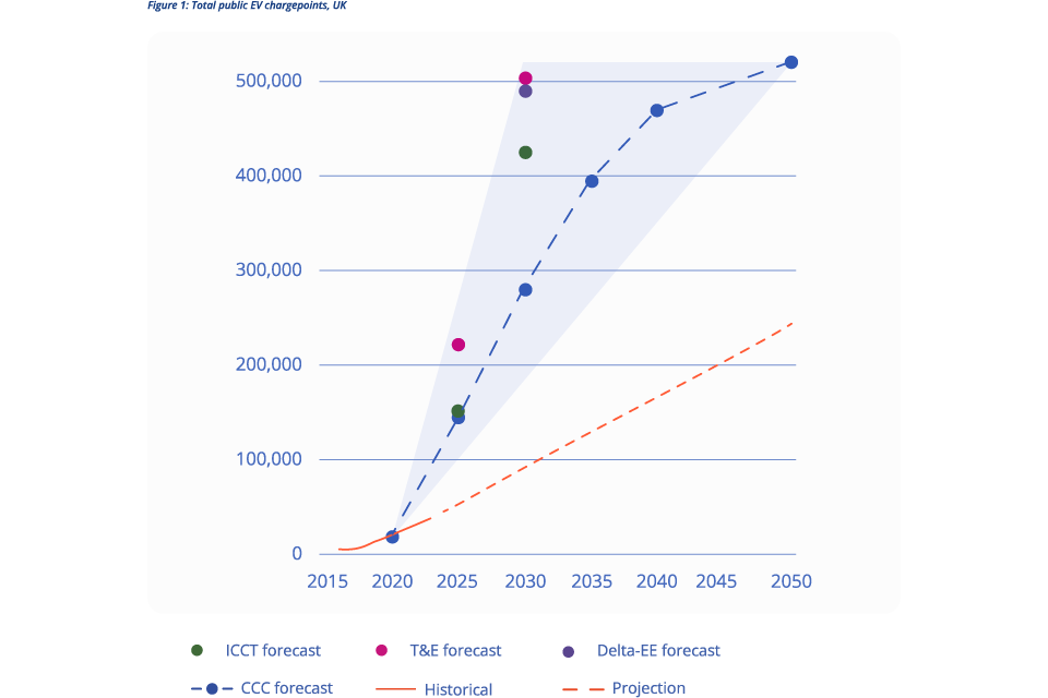
The graph highlights how there is a high degree of uncertainty surrounding the predicted number of public chargepoints required in future through displaying 4 different projections with each forecast based on different assumptions.
The geographical distribution of public chargepoints across the UK is uneven. As shown in Figure 2, there are significant differences between nations, regions and local authorities. More than 30 percent of chargepoints are in Greater London.
Figure 2: The geographical distribution of public chargepoints across the UK is uneven

Map showing that the geographical distribution of public chargepoints across the UK is uneven. The map shows devices per 100,000, highlighting significant differences between nations, regions and local authorities.
Of course, public chargepoints do not have to be spread evenly - factors such as levels of car ownership and access to private parking mean demand for public chargepoints is highly varied at small geographic scales. A simple analysis of chargepoints per capita by local authority area (as in Figure 2 above) ignores significant street-level differences in supply and demand. Factors like population demographics, availability of off-street parking, and energy infrastructure have a significant bearing on chargepoint requirements and commercial viability.
Small scale demand modelling can reveal significant differences at granular scales. Figure 3 shows one example of this type of modelling, which takes points of interest, population census data, traffic data and a model of chargepoint usage to pinpoint specific areas that are likely to require public chargepoints.
Figure 3: Street-level factors have a significant bearing on chargepoint viability

screenshot of Advanced Infrastructure’s LAEP+ net zero planning tool. This view combines points of interest, population census data, traffic data and a model of chargepoint usage to highlight sites with high forecast utilisation rate.
Effective public chargepoint strategies must be spatially targeted, focussing public resources to the locations where public chargepoints are needed most. An overall national target is difficult to formulate - what matters more are spatially targeted local and regional strategies that also support longer distance travel.
What is location data
Location data, or ‘geospatial data’, is the record of what we do and where we do it. It tells us where people and objects are in relation to a particular geographic location, whether in the air, on the ground, at sea or under our feet.
The crucial role of local authorities
The vast majority of chargepoint rollout will be delivered by the private sector - stimulating UK investment and growth and creating jobs across the country. The majority of drivers will do most of their charging at home, overnight, and the private sector is expanding chargepoint provision in workplaces and homes. But we also need public chargepoints to enable long distance journeys and to support those without off-street parking.
Local authorities are at the heart of the multi-stakeholder approach that is required to deliver public chargepoints effectively. They are responsible for overarching planning policies in their areas, including street alterations and parking. They usually also own lamp posts, bollards and local car parks, which can be adapted to incorporate charging infrastructure.
As private sector chargepoint provision expands in workplaces and homes, local authorities are turning their focus to addressing gaps in chargepoint provision. There is a need to identify poorly served locations, consider issues such as social inclusivity and provision across rural and urban communities. Provision of on-street chargepoints by local authorities will be particularly important to meet these gaps. The Competition and Market Authority has identified that there needs to be a “step change in the role that local authorities are currently taking in on-street charging and the support available to them”.
Some local authorities have begun developing chargepoint delivery strategies, but to date, the focus of most local authorities has been on localised, tactical initiatives. Many local authorities are already involved in the procurement and deployment of public chargepoints, with those not currently involved making plans to do so in the near future. As the pace of chargepoint rollout increases and the market grows, the role of local authorities will need to adjust accordingly. They will need to be both more responsive to demand and more proactive in identifying sites that are left unserved.
In future, local authorities will need to consider chargepoint provision across geographic and administrative boundaries, model demand including from visitors originating outside their jurisdiction, understand commercial and private chargepoint provision, and better integrate chargepoint provision on local roads with the strategic road network.
Who are the key actors behind public charging?
Local Authority (LA) An organisation that is officially responsible for all the public services and facilities in a particular area. Responsible for overarching planning policies in their areas, including street alterations and parking. Usually own the lamp posts, bollards and local car parks, which can be leased to CPOs to install chargepoints.
Chargepoint Operators (CPO) Install, manage, maintain and operate chargepoints and the charging stations (both technical and administrative).
Distribution Network Operator (DNO) Companies licensed to distribute energy to homes and businesses. They own and operate the distribution network. There are 14 licensed DNOs in Great Britain covering different geographic areas.
The Geospatial Commission approach
The Geospatial Commission is an expert committee within the Cabinet Office, responsible for setting the UK’s Geospatial Strategy and coordinating public sector geospatial activity.
The UK’s Geospatial Strategy, published in 2020, identifies transport as one of nine location data opportunity areas. The Geospatial Commission has established a Transport Programme to assess how location data can support the future of mobility, which has so far:
-
Invested £5m in a Transport Innovation Competition which brought market innovators together with transport challenges to deliver novel solutions and bring these to market.
-
Published Positioning the UK in the fast lane (2020) which set out the potential for location data to support a greener, faster, better transport sector. The report was informed by a Transport Taskforce made up of 17 organisations and seven industry roundtables engaging 48 transport sector representatives. The report identified a specific opportunity to use location data to support EV chargepoint rollout.
The Transport Location Data Competition
The Geospatial Commission partnered with Innovate UK on the Transport Location Data Competition to look at how location data can spark innovation and support the future of mobility in the UK. The Transport Competition invested £5 million across 28 projects, with seven projects taken forward to a second phase of commercial development. One of these was Dynamon.
Dynamon has developed a web-based data analytics tool, called ZERO, which helps commercial transport companies optimise their transition to zero emission vehicle (ZEV) fleets. ZERO enables fleet teams to identify the optimum ZEVs and charging infrastructure based on their unique operation and depot electricity constraints.
ZERO works by combining geospatial datasets (fleet telematics data, terrain data, weather data, traffic data, charge point data) with ZEV performance data obtained from Dynamon’s industry leading ZEV testing program. Dynamon has identified 4.9 million km driven each day by large fleets that could transition to zero emission vehicles.
In March 2022, the Geospatial Commission launched a discovery project with nine local authorities to explore what data they need to support the rollout of public chargepoints. These findings were tested in a UK-wide survey which received responses from 21 local authorities.
This research was supplemented with a range of engagement across the public sector and industry. In October and November, the Geospatial Commission hosted two roundtables which brought together EV stakeholders including chargepoint operators and organisations innovating with location data.
The Geospatial Commission’s research and engagement has confirmed the critical role location data plays in chargepoint strategy and delivery.
Challenge 1: Modelling future demand
Predicting how many chargepoints are needed, and where they should be located, is inherently difficult. Modelling future demand needs to account for where people will live, how they will behave and travel, and how technological developments in the manufacture of electric vehicles, chargepoints and charging will expand consumer choice.
An additional complexity is that chargepoint availability itself creates demand. If motorists are to feel confident to transition to EVs, chargepoint rollout needs to stay ahead of demand. It is also likely that the preferences of EV early adopters will be different from late adopters. Speeding up the transition means having a better understanding of where tomorrow’s demand will be.
Location data can help local authorities and chargepoint operators plan for the future by undertaking demand modelling, identifying off-street parking and understanding consumer preferences.
How demand modelling can unlock smarter rollout of public chargepoints
Chargepoints needs will vary significantly between local authorities. Local authorities and chargepoint operators (CPO’s) need to consider a range of factors when identifying where to locate public chargepoints.
-
Areas with seasonal, tourism-related economic activity may need charging infrastructure next to retail and leisure destinations, capable of charging EVs very quickly. Residential areas with lots of flats and terraced housing, away from commercial activity, may need more on-street chargepoints capable of slower, overnight charging.
-
Rapid or ultra-fast chargepoints may be in more demand in city centres than in more remote rural areas, as the former is likely to experience more onward journeys through their local areas.
-
Where parking is very limited or in conservation areas, EV drivers could be better served through a “charging hub” (multiple chargepoints in a single location such as a car park). Ideally planners should model where these hubs should be placed, and the associated impact on demand and local congestion.
-
Sites need to be assessed on their suitability and capability for chargepoints, including whether a street or area has protected heritage status or whether there is enough grid capacity in the area.
Spatial demand modelling can help local authorities and CPOs to choose the right number, type and locations of chargepoints. Modelling can be used to understand citizen behaviours, travel patterns and infrastructure constraints in order to more efficiently and effectively plan, procure and rollout chargepoints.
Without demand modelling, the public sector risks targeting public funds towards locations that the market will serve anyway, paying for chargepoints to be installed where there is no demand (e.g. abundant off-street parking) or setting commercial terms which do not match the market’s expectation of profitability (e.g. lease terms that are too short or too long).
Case Study: Oxfordshire County Council and Mind Foundry
Machine learning pinpoints EV demand
Oxfordshire County Council has partnered with Mind Foundry, an Oxford University company, to use advanced spatial demand modelling to identify the right places to install public chargepoints.
The Mind Foundry Platform combines geospatial modelling with a variety of different data sources and advanced uncertainty awareness forecasting to predict future requirements for EV charging infrastructure.
The platform is powered by machine learning and connects to both live and historic data sources, providing sophisticated scenario modelling. These forecasts are sensitive not only to immediate demand, but long term strategy. The platform can monitor the available electricity capacity, enabling smart, data driven resource optimisation.
This has allowed Oxfordshire County Council to visualise and analyse immediate demand, local constraints and individual needs to make decisions about EV chargepoints. They are also able to analyse potential sites and determine their suitability working within the policy set out in their local EV infrastructure strategy and quickly produce more accurate and targeted applications for chargepoint funding
Improve access to demand modelling
Demand modelling has the potential to provide planners with evidence on where to target chargepoint provision, down to the street-level.
However, modelling demand for chargepoints can be challenging for local authorities. There is variability across local authorities in their use of modelling to understand demand. Due to local authorities facing multiple complex demands on their constrained capabilities, most do not undertake demand modelling for chargepoint planning. They are often outsourcing this important work to a consultancy, or using a chargepoint operator’s own analysis which could put the local authority at a commercial disadvantage.
Examples of EV demand modelling include:
- Transport for the North has developed the EVCI Framework for local and national government using regional analytics to develop a rich, place-based understanding of charging need
- Oxfordshire County Council is working with Mind Foundry to combine geospatial modelling with a variety of different data sources and advanced uncertainty awareness forecasting to intelligently model and predict the changing requirements for EV charging infrastructure
- The Energy Saving Trust through its Local Government Support Programme provides analysis to support to local authorities in England with chargepoint planning, including a map-based analysis of potential locations
- The Welsh Government has commissioned Arup to design a tool to map out an idealised EV charging network for Wales to encourage the public and private sectors to invest in new chargepoints in a way that meets future chargepoint demand. Using behavioural, geographic and demographic data and,
- A few potential solutions are in development or available from the market, including Advanced Infrastructure’s LAEP+, which allows users to create custom maps populated with hundreds of datasets and run analysis to identify the suitability of different sites
A widely available approach to demand modelling would equip local authorities to more efficiently and effectively commission public chargepoints. It would also provide central government with new information, opening up options to more effectively target funds and track outcomes.
ACTION
By June 2023, the Geospatial Commission will deliver a feasibility study into how to widen access to demand modelling, including whether existing models can be scaled up.
Improving coordination to support public sector buying decisions
The market for EV charging infrastructure is evolving: with product innovation, consolidation across suppliers and an evolution of different ownership models. This complexity demands expert input into public sector sourcing decisions and having access to a wide range of data to make informed decisions on site selection.
Better coordination across public sector buyers, underpinned with improved demand forecasting could deliver significant savings, improve utilisation rates and encourage interoperable solutions that will benefit users. The Crown Commercial Service (CCS) works with public sector organisations to support the rollout of chargepoint infrastructure using two commercial agreements. (Vehicle Charging Infrastructure Solutions (VCIS) and Transport Technology & Associated Services)
CCS offers the public sector an aggregation service, also known as collective buying.By combining similar charging requirements of customers from across the public sector, CCS can increase their national buying power to achieve savings that would not be possible through an individual procurement.
Improve data about off-street parking
Households with off-street parking, such as driveways or garages, are more likely to use their own private chargepoints for the majority of their charging needs. Households in neighbourhoods which do not have private driveways will rely on public EV chargepoints, either on-street or in dedicated charging hubs.
While an established standard for managing data for on-street parking exists[footnote 1], there is no standardised geospatial dataset that identifies areas without off-street parking. A range of ‘proxy’ approaches are sometimes used. For example, some planners use OS AddressBase[footnote 2] to identify residences which are more likely to have off-street parking, such as detached properties. There is potential to use existing remote sensed data, such as satellite imagery and aerial photography, with advanced image processing techniques to identify areas without off-street parking.
Using geospatial data to help assess the potential for private residential EV charging
The analytics consultancy Field Dynamics used Ordnance Survey (OS) data to create a highly granular model to assess the number of properties across Great Britain that have at least a 21.1m2 rectangle of adjacent outside space that is easily accessible from a road. If this is the case, the property has the potential to accommodate an EV for charging.
Using OS AddressBase data, Field Dynamics were able to understand the number of households in any given location. The OS MasterMap Topography Layer helped identify property types, boundaries, adjacent roads, footpaths and pavements. Building on that foundational data, Field Dynamics established a way to uncover the deeper context and relationship between features, such as homes, driveways and adjacent grass verges, so that the potential EV charging landscape can be understood.
A geospatial dataset would help local authorities and chargepoint operators identify areas without residential off-street parking and support smarter deployment of public chargepoints to households without access to private charging infrastructure.
ACTION
By June 2023, the Geospatial Commission will explore the creation of a geospatial dataset for off-street parking, considering existing sources of data and how to safeguard privacy.
Use new data to understand consumer preferences
Where and how often people use cars should be an important consideration for planners of public chargepoints. Fortunately, there has been a proliferation of consumer location data that can provide a rich geospatial picture of this, from the digital records of card payments to location data collected by smartphone apps. For instance:
- Mobile phone location data, anonymised and aggregated, can provide high frequency and low latency information at small geographies,
- Card payment data, suitably anonymised and aggregated to protect individual privacy, can provide insight about where people stop on a long journey, and for how long they stay,
- Modern vehicles contain a vast number of sensors. Combined and aggregated, data from these sensors can provide powerful insights into travel patterns, vehicle usage and performance in different conditions,
- The road network contains sensors that can monitor conditions, communicate with connected and autonomous vehicles and manage traffic. Ngenius.ai, funded through the Geospatial Commission’s Location Data Transport Competition, is a technology start-up deploying Artificial Intelligence (AI) which uses existing CCTV hardware to provide novel, advanced traffic and active travel monitoring data,and,
- Chargepoints themselves can collect information on utilisation, duration and cost for people charging at that specific location. They are also able to install bay sensors, which allow detection of improper use of an EV charging bay.
However, while some of the above data can be found in certain EV demand models, it is often not economical or practical for individual local authorities to access and use.
The Geospatial Commission has commenced a cross-government initiative to understand opportunities to align public sector requirements for mobility data. This will examine a range of use cases including chargepoint rollout.
ACTION
By June 2023, the Geospatial Commission will examine how aggregated and anonymised mobility data could be applied to inform chargepoint rollout.
Challenge 2: Finding suitable sites
Once demand has been established, the next stage is assessing whether sites are suitable for chargepoint installation. Location data can accelerate this process, helping planners and CPOs identify where chargepoints can be installed to avoid wasted effort.
Site selection typically includes detailed assessments and surveys about prospective locations for chargepoints. Planners engage with local stakeholders and identify any legal considerations, including who owns the land and whether planning permission is required. Where sites are identified, submissions are made to the relevant distribution network operator to check if there is sufficient network capacity and to provide cost estimates for connection to the network. Planners also carry out assessments of other constraints, including the surrounding sub-surface and surface level assets (for example underground pipes and cables, lamp posts and, trees).
Location data can speed up site selection by improving our understanding of energy capacity and identifying site constraints, hazards and opportunities on the kerbside.
Using geospatial data to identify land ownership and availability
Once demand is understood, establishing who owns a site and whether it is available is an important step in determining the right locations.
Planners and developers can use HM Land Registry’s MapSearch to find out if a property is registered, obtain its title number and details of tenure and obtain ownership details through a paid search. Users with Geographical Information Systems tools can use INSPIRE polygons to add a layer onto their own maps to obtain information details before carrying out a paid search.
The market is innovating to make searches for land information more accessible. For example, SearchLand combines data from HM Land Registry, National Grid, Companies House, Environment Agency, Historic England and local planning authorities. By making this data available through a single, searchable platform, users can save significant time previously spent searching multiple sources and platforms.
Case study: SSEN Regional Energy System Operation Planning (RESOP)
Automating grid connection estimates
Scottish and Southern Electricity Networks (SSEN), a Distribution Network Operator (DNO), has partnered with Advanced Infrastructure, a data science and software company, to create LAEP+, a geospatial mapping tool to support local authorities.
LAEP+ combines local authority data, such as building types and street furniture, with electricity network data from SSEN. Additional data, such as pavement suitability, conservation areas, demographics and likely use of EV chargepoints, is also included. This data is used to create a platform which:
- Highlights areas according to their energy capacity
- Auto-connects the prospective chargepoint to the closest cable, provides a budget estimate and indicates if there are existing applications to install chargepoints to the same feeder or substation
- Links to Navi, SSEN’s internal power flow tool, to indicate whether additional network reinforcements might be needed or if any other constraints exist
In the future, LAEP+ will be able to store Local Area Energy Plans (LAEPs), which will enable DNOs to anticipate future electricity demand and invest in network upgrades ahead of time.
Understand local energy capacity
The energy system must expand and adapt to enable the mass uptake of EVs, in addition to other demands to deliver net zero, as recognised in the government’s recent Electricity Networks Strategic Framework.
This is not just about generating more electricity from new low carbon sources, but also ensuring that new grid connections can be made quickly. Where multiple chargepoints are installed, such as at charging hubs or car parks, a new connection can sometimes create a need for wider network infrastructure upgrades.
Local authorities have a central role to play in influencing energy demands within their area - from planning permissions for new housing developments, through to the creation of new chargepoints. However, they can find it difficult to obtain timely and granular data about the capacity, availability and cost of power at a given location. The lack of data can hinder chargepoint location planning at a strategic level:
- Planners need to request detailed assessments on a site-by-site basis, meaning large numbers of enquiries become time consuming
- Local authorities that span multiple distribution network operators (DNOs) have the additional challenge of working through different engagement processes
- Information can arrive late in the process, meaning sometimes significant site assessment work is undertaken only for the DNO to advise that there is insufficient grid capacity, adding delays and wasting resources and,
- The price of the electricity connection can be the most variable cost factor and determine whether a site is affordable
Initiatives are underway to address these issues and improve the quality and accessibility of more timely, detailed and standardised data about the energy network. The energy sector is developing solutions to make data on their assets more accessible and interoperable to enable greater collaboration with local authorities.[footnote 3] Some DNOs are also making their data available through their own platforms.[footnote 4]
In July 2022, the government responded to the recommendations of the Energy Digitalisation Taskforce, recognising that to truly deliver interoperability in the energy sector requires considerable action. As part of the action plan, BEIS will conduct a feasibility study to examine the opportunities, risks and potential architectures of a ‘digital spine’ - a technical framework that allows the exchange of energy system data in a secure and interoperable manner.
If successful, this could provide the means to collect, standardise, present and exchange the data in a simple and secure way.
More accessible, timely data at the right spatial scale about energy availability and capacity will help planners identify suitable sites for new chargepoints and inform strategic chargepoint and energy planning for the future.
ACTION
In 2023, BEIS will conduct a feasibility study to examine the needs case, benefits, scope and costs of an energy system ‘digital spine’ to support interoperability across the sector.
Identify site constraints, hazards and opportunities on the kerbside
Critical to determining site suitability is knowing where physical constraints are, both on the surface and buried underground. Location data can significantly reduce wasted effort and improve safety.
The location of kerbside assets, such as lampposts, substations and fibre cabinets, all come into play when assessing whether a site is capable of accommodating a chargepoint. In addition, the location of buried assets, such as underground cables and pipes, often play a determining role.
Local authorities and chargeoint operators (CPOs) do not currently have readily available information on buried assets in streets at an area-wide scale. Instead, they must conduct searches with individual organisations and the data provided could be in a variety of formats, scales and quality. Inefficient searches can lead to local authorities and CPOs wasting time and resources on unnecessary site investigation. In worst case scenarios, ground excavations can cut through a gas or electricity main, causing significant disruption and risk to life.
ACTION
The Geospatial Commission will deliver the National Underground Asset Register (NUAR). Once operational, planners will be able to consult NUAR in the planning, excavation and installation of new public charge points.
National Underground Asset Register (NUAR)
NUAR is a live Geospatial Commission programme which will improve data sharing practices between underground asset owners (AOs) and those that plan, install and maintain these pipes and cables. The NUAR platform is currently being developed and tested.
The first phase of the programme focused on developing the platform and onboarding AOs in North East England, Wales and London. We are now onboarding remaining asset owners in England and Northern Ireland. The service makes it easier for over 650 AOs to fulfil their statutory obligations and improve efficiency and safety.
NUAR will be operational from September 2024 and is estimated to bring c.£350 million in benefits per annum through efficiency savings and reduced accidental asset strikes.
Challenge 3: Creating a seamless consumer experience
Consumers increasingly expect their digital experience to be seamless. An EV driver expects their route planner to plot a journey to a destination that automatically accounts for battery capacity and the need to recharge and identifies operational, compatible chargepoints and their price.
Currently, this is not the case and a disjointed charging system is sapping consumer confidence to make the switch to EVs. Almost half of non-EV drivers (45%) have ‘range anxiety’ - are anxious about battery range. Meanwhile, one in five non-EV drivers say that having to research the location of chargepoints when on a long journey is stopping them from switching to EVs.
Drivers must be able to find and use a chargepoint when they need to. Innovative use of location data can create a seamless charging experience that gives drivers confidence to switch to an EV. In the future, vehicles could have a real-time awareness of chargepoint availability, select chargepoints depending on accessibility and amenity requirements and amend bookings based on arrival time.
The market will drive this change, but only if the necessary data foundations that enable digital innovation are in place. Accessible, standardised location data will allow innovators to provide a more seamless experience for drivers. Chargepoint data needs to be findable, accessible, interoperable and reusable (FAIR).
Case study: Transport for London (TFL)
FAIR data empowers consumers and improves journeys
By releasing real-time data about the travel network, Transport for London (TfL) created the conditions for innovation, leading to a revolution in how people make use of public transport.
TfL made data covering London transport networks available in real-time via APIs. This includes both static data - such as timetables and accessibility - and dynamic data - such as timetables and service disruption. Market innovators have used this data to create customer-facing products and applications, such as CityMapper and Google Maps travel integrations, to improve the experience of passengers and integrate with private travel options such as ride sharing or active travel.
Transport users now expect access to up-to-date information on travel disruptions when making travel decisions. Without the right information, users could have poor travel experiences and spend more time travelling than they should.
Similarly, EV drivers must be able to find and use a chargepoint when they need to. Currently, their inaccessibility, perceived or real, is contributing to the range-anxiety stopping many prospective EV owners from switching. TfL has committed to develop a real-time and open API of all chargepoints in London, subject to funding.
Make chargepoint location data FAIR
Delivering an improved customer experience starts with accurate and timely data about where public chargepoints are located. To be useful, the data has to be FAIR.
What is FAIR?
The FAIR principles for data were originally proposed in 2016, primarily aimed at increasing the ease with which data can be processed by machines. In 2021, the Geospatial Commission developed Q-FAIR to account for the user requirements for FAIR improvements to data products and services. In summary these are:
Quality: The content of the dataset is suitable for its intended use
Findable: Data that can be found easily and repeatedly by an end user
Accessible: Data that can be easily and repeatedly accessed by an end user
Interoperable: Data that can be utilised in many commonly used systems of the day
Reusable: Data that is designed with use in mind and has value in reuse
Currently there are two main sources of information on where public EV chargepoints are. These are the National Chargepoint Registry (NCR), which is a free portal provided by DfT and Zap-Map, which sources information from chargepoint operators (CPOs).
DfT has recently announced plans to close the NCR and is currently legislating to mandate CPOs to make static and availability data [footnote 5] about their chargepoints freely available in accordance with the Open Charge Point Interface Protocol (OCPI) standard. Making chargepoint data FAIR will optimise the consumer experience, enabling better integration of data into everyday services and products.
ACTION
The government is legislating to mandate chargepoint operators (CPOs) to make data about their chargepoints available in a standard format.
Accurate, interoperable and up-to-date chargepoint data will stimulate innovation in the market and in turn provide consumers with a range of products and services so they can find and charge with ease.
Local authority planners will also benefit from market innovations. By improving access to data on where and what types of chargepoints are available, planners will be able to better understand demand gaps in their local areas to influence public and private investment in new chargepoint provision.
ACTION
As the government continues with its plans to make chargepoint data more FAIR, the Geospatial Commission will track how market innovators use the data to create products and services which enhance the consumer experience.
Challenge 4: Tracking rollout
The UK government has a vision for a chargepoint network that reaches everyone, everywhere. To deliver all of the public chargepoints that the UK needs, the government will need to monitor rollout and identify where demand is not being met by the market.
However, monitoring rollout is not as simple as tracking an overall national figure against what is estimated to be required by 2030 or 2035. The government has committed to keep track of progress, using metrics to identify if and where the market fails to deliver. Reporting publicly on chargepoint provision and regional rollout will continue.
Successful delivery of public chargepoints needs to be evaluated in spatial terms to ensure that chargepoints are being delivered in the right place at the right time. Monitoring rollout will need to take into account different local needs between areas.
Spatially-informed metrics can support central government and local authorities to track where rollout is meeting demand for public chargepoints.
Case study: Transport for the North EVCI Framework (TfN)
Tracking chargepoint rollout across local authority boundaries
Transport for the North (TfN) has developed a tool to support local, regional and national partners to build a comprehensive EV charging network that satisfies current and future demand.
The EV Charging Infrastructure Framework provides planners with a view, across local authority boundaries, of the scale and pace of chargepoint rollout required to meet the right infrastructure needs in the right place, at the right time.
The platform applies TfN’s regional Analytical Framework to provide robust evidence which quantifies the different requirements for charge points within specific localised geographic areas. The tool also translates charging needs into forecasts of additional demand on the electricity grid to better inform ‘whole systems’ planning and delivery across sectors.
It combines a range of datasets that indicate potential demand for EV charging, including:
- Spatial data, including land use, household type and parking availability
- Socio-economic data
- Cross-local authority boundary vehicle flows on the road network
- The origin, destination and purpose of travel for car, van and HGV users
- Projected EV fleet uptake and transport demand across future travel scenarios.
Central government and local authorities can use the tool to track rollout of chargepoints by comparing forecasted requirements against actual deployment (recorded in the National Chargepoint Register or Zap Map). This can be done manually now, however TfN are developing enhancements to its Framework which will provide a live monitoring and evaluation capability for demand versus actual. Further data sharing in the future may open further avenues to speed up delivery, such as indication of planned deployments and electricity grid reinforcements.
Develop spatial metrics that take into account local demand
The UK government has committed to develop improved metrics to monitor provision and disparities between local areas while accounting for local needs, and to spot where the market fails to deliver, taking into account the uncertainty around future need.
Meaningful metrics need to be set in the context of differences in local demand. For example, looking at the number of chargepoints per 100,000 of the population is not a fair understanding of whether supply is meeting demand because there are differences in demand between different areas. Below average levels of public chargepoints for every 100,000 of the population may not be an issue if car ownership rates in the same area are low, or availability of off-street parking is high.
Delivery therefore needs to be assessed place by place in the context of changing demands. This means undertaking sufficient demand modelling, comparing this to the record of where public chargepoints are being installed by the market, and making an assessment of the gap - taking account for how spatial differences in demand change over time.
Private residential and workplace chargepoint provision is expected to grow quickly in the coming years and a key role for the public sector is to fill gaps in commercial provision and install chargers where commercial suppliers will not. Improving access to chargepoint data and demand modelling will significantly help monitoring of provision.
ACTION
Government will consider developing spatial metrics which use demand modelling to track regional disparities, while accounting for differences in local need.
Acknowledgements
Our engagement for the Getting to the Point report
Public Sector
Ards and North Down Borough Council
City of York Council
Clackmannanshire Council
Cornwall Council
Coventry City Council
Department for Business, Energy and Industrial Strategy
Department for Housing, Levelling Up and Communities
Department for Transport
Dorset Council
Dundee City Council
Greater Manchester Combined Authority
HM Land Registry
Hull City Council
Kent County Council
Leeds City Council
Liverpool City Council
Medway Council
Mid and East Antrim Borough Council
Milton Keynes Council
Norfolk County Council
Northern Ireland Executive
Office for Zero Emissions Vehicles
OFGEM
Oxfordshire County Council
Rotherham Metropolitan Borough Council
Ryedale District Council
Scottish Borders Council
Scottish Futures Trust
Scottish Government
Solihull Metropolitan Borough Council
Transport for London
Transport for the North
Welsh Government
West Sussex County Council
Wiltshire Council
Wirral Council
Worcestershire County Council
Industry
1Spatial
Advanced Infrastructure
AGI
Cenex
Char.gy
Connected Places Catapult
ConnectedKerb
Emu Analytics
EV Energy Taskforce
Energy Savings Trust
Energy Systems Catapult
Field Dynamics
Geoplace
Geospatial Insight
Google
Icebreaker One
Jacobs
Ordnance Survey
Osprey Charging
Scottish Power
Scottish and Southern Energy
SearchLand
Space Syntax
Tesla
Ubitricity
UK Power Networks
Urban Data Collective
ZapMap
Acronyms
AI - Artificial Intelligence
APDS - Alliance for Parking Data Standard
BEIS - Department for Business, Energy and Industrial Strategy
CCC - Climate Change Committee
CCS - Crown Commercial Service
CPO - Chargepoint Operator
DfT - Department for Transport
DNO - Distribution Network Operator
EV - Electric Vehicle
EVCI - Electric Vehicle Charging Infrastructure
FAIR - Findable, Accessible, Interoperable, Reusable
HMLR - HM Land Registry
ICCT - International Council on Clean Transportation
LA - Local Authority
LAEP - Local Area Energy Plan
LEVI - Local Electric Vehicle Infrastructure
NCR - National Chargepoint Registry
NUAR - National Underground Asset Register
OCPI - Open Charge Point Interface Protocol
ORCS - On-Street Residential Chargepoint Scheme
OS - Ordnance Survey
OZEV - Office for Zero Emission Vehicles
PSGA - Public Sector Geospatial Agreement
SSEN - Scottish and Southern Electricity Networks
T&E - Transport & Environment
TfL - Transport for London
TfN - Transport for the North
UKPN - UK Power Networks
UPRN - Unique Property Reference Number
ZEV - Zero Emission Vehicle
-
The Alliance for Parking Data Standard (APDS), developed by and with parking operators to allow for a common and consistent understanding of parking assets and utilisation across different areas. ↩
-
AddressBase is Ordnance Survey’s addressing product that matches 29 million Royal Mail postal addresses to unique property reference numbers (UPRN), bringing a geographical dimension to the matched records. Public sector organisations can access this product through the Public Sector Geospatial Agreement (PSGA). ↩
-
For example, the Energy Networks Association worked with Ordnance Survey and 1Spatial to build a proof-of-concept National Energy System Map showing information about energy network assets, capacity of those assets, where they are located as well as who owns them. ↩
-
UK Power Networks (UKPN) is providing 100 free-to-use datasets on its Open Data Portal to help local authorities achieve their net zero targets. The datasets range from wind speeds, flood zones and socio-economic data to electricity network maps and information about where there is extra capacity. ↩
-
Static data means information that does not change frequently about a chargepoint including but not limited to - location, connector type, payment method, price and time restrictions. Availability data means information about whether the chargepoint is working and is available to use. ↩