National Underground Asset Register Project Update
Updated 1 July 2020

© Crown copyright 2020
This publication is licensed under the terms of the Open Government Licence v3.0 except where otherwise stated. To view this licence, visit nationalarchives.gov.uk/doc/open-government-licence/version/3 or write to the Information Policy Team, The National Archives, Kew, London TW9 4DU, or email: psi@nationalarchives.gov.uk.
Where we have identified any third party copyright information you will need to obtain permission from the copyright holders concerned.
This publication is available at https://www.gov.uk/government/publications/national-underground-asset-register-project-update/national-underground-asset-register-project-update
An introduction to the Geospatial Commission
The Geospatial Commission was established in 2018 by the government as an independent, expert committee responsible for setting the UK’s geospatial strategy and coordinating public sector geospatial activity. Our aim is to unlock the significant economic, social and environmental opportunities offered by location data and to boost the UK’s global geospatial expertise.
The Geospatial Commission has a mandate and budget to drive and deliver changes by working in partnership with others. This means we:
- Provide strategic oversight of the geospatial ecosystem in the UK, setting geospatial strategy, policy and standards;
- Hold the budget for the public sector’s largest investment in strategically important geospatial data via the Public Sector Geospatial Agreement;
- Make targeted investments in data projects that accelerate innovation and the adoption of geospatial data applications.
We have a formal relationship with six partner bodies: The British Geological Survey, Coal Authority, HM Land Registry, Ordnance Survey, UK Hydrographic Office and the Valuation Office Agency.

excavation in north London showing buried pipes and cables
The need for good quality geospatial data for the construction and infrastructure sectors
Every day, we rely on a wide range of services that we often take for granted. Our national infrastructure keeps the lights on, water flowing, internet connected and transport moving. This all needs to be done in a way that is well designed, and affordable for the government and the public. Data and digital connectivity will drive the UK’s recovery, competitiveness and quality of life.
There is huge potential for location data to improve the way that national infrastructure is planned, built and managed, from informing where our future gigabit broadband and 5G networks need to go, to planning how and where to connect utilities, and designing new housing developments.
In 2018 initial analysis suggested that more accessible and better quality location data in infrastructure and construction could be worth over £4 billion per year.[footnote 1] The Geospatial Commission is committed to prioritising activities where there is a clear case for government intervention. In addition, accidental strikes on underground assets are estimated to cost £1.2bn a year in direct and indirect cost.
Our first intervention in this sector is to better map underground assets. Every construction and infrastructure project has to source information on buried utility assets such as cables, pipes, sewers and ducts when preparing ground investigation and excavation work. Multiple different organisations have to be contacted with their data delivered in varied formats, scales, quality, and on different timelines. This is hugely inefficient and results in an increased risk of asset strikes with potentially lethal consequences as well as project delays, cost overruns and disruption to traffic and local economies.
The need for market intervention
We believe the current system is unlikely to reform itself as there is no single asset owner who bears the wider societal costs from utility strikes such as potential loss of life, injury, wider project delays and traffic disruption.
Reliable and secure data sharing is also a large-scale coordinated task, requires significant upfront investment and can involve commercial sensitivities, all of which are major barriers to change.
The Geospatial Commission recognises the important role that utility search providers play to help avoid strikes and to keep workers safe. The results from user testing during the NUAR pilot do however indicate that there are limitations to these services which could be addressed through the introduction of a comprehensive digital map showing all underground pipes and cables. In the future there could be potential to integrate the NUAR platform with other utility search and information services.
The Geospatial Commission is well positioned to investigate and provide potential solutions as it considers the economic, social and environmental values of geospatial data, We have resources and co-ordination expertise from being positioned at the heart of Government, in the Cabinet Office.

Image of city and underground pipes
Focus of the pilots
The aim of the NUAR pilots was to create a secure data exchange platform to provide a digital map of where assets are located, test its usability and if it can have any impact on the likelihood of asset strikes and project inefficiencies.
The pilots also helped to address the Geospatial Commission’s wider programme in a number of areas including:
- Data sharing frameworks and mechanisms, particularly between private sector organisations.
- Data security and the need to balance security with safety benefits from fewer asset strikes.
- Understand the legalities and liabilities with sharing of infrastructure data [footnote 2].
- Understand data modelling, specifically how data can best be brought together from both private and public sector organisations and displayed in a single view.
Background
In April 2019 the Geospatial Commission announced a twelve month ‘National Underground Asset Register’ (NUAR) pilot.The aim was to increase the government’s understanding of how such a register could be designed and managed.The overall cost was £2.4 million.Each pilot provided insight and evidence to inform an approach for how a national programme could be rolled out.
The pilots were aimed to design and test what a mapping platform could look like to help asset owners, such as telecommunication, energy and water companies and local authorities securely share their existing underground asset data with authorised users.
The objectives of the pilots were as follows:
- Demonstrate the value of the data exchange platform against the use cases.
- Provide data specifications and standards.
- Test the functionality of the prototype.
- Better understand the costs for the tender and national platform.
- Better understand barriers and pathways to participation.
- Learn about systems models and approach.
Early research identified two suitable areas for launching pilots:
-
In the north east of England, the North East Underground Infrastructure Hub (NEUIHub) was created following Northumbrian Water Group’s 2018 Innovation Festival.
-
In London, the Highways Apparatus Data Exchange System (HADES), an early proof of concept, was initiated in 2017.
These two areas were chosen because of their potential to capitalise on the existing expertise, momentum and stakeholder buy-in that could then be harnessed as a foundation for the broader NUAR programme.The Geospatial Commission’s Partner Body, Ordnance Survey, was contracted as delivery lead for the north east region whilst the Greater London Authority was chosen for London.
The research team also built strong relationships with colleagues operating the VAULT system in Scotland, the KLIP system in Flanders and KLIC system in the Netherlands.Their cooperation and practical advice proved vital throughout the project.
The team also had strong and continuous engagement with businesses in the UK’s buried asset market to learn from their experiences and to shape the design of a national system balancing the potential disruption to existing markets with overall efficiency gains and opportunities for new innovations and enterprises.
Each pilot had approximately 25 participants which clearly demonstrated the high value that high participation can unlock.
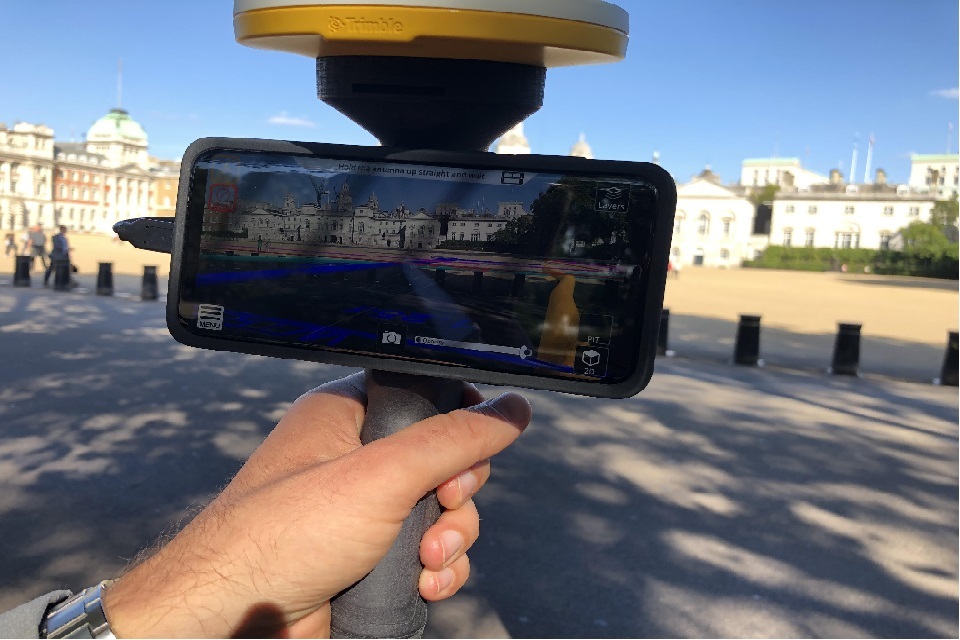
Image of mixed reality application device
Project endorsement
Quick wins from the pilots have proved invaluable. Informal feedback from a planner informed us that the time taken on the creation of a job pack was reduced from 1 hour 30 minutes to just 7 minutes using the NUAR platform. Anecdotal evidence from a Civils Manager stated that as a high level estimate they could save up to £1m per year just on streamlining the planning process for obtaining utility plans. We plan to continue to quantify the economic benefits to help build the evidence base for any future national rollout plans.
Repairs engineers have also commented on how the service will enable evidence-based decisions, increasing customer satisfaction and reducing operational costs and fines. Incident responders have commented on the difference this will make to their confidence levels in putting safety first for their excavator teams as they receive an instant integrated map view of all critical utility assets.
“From a safety perspective you cannot put a price on this – its absolutely amazing” Team Leader, Northumbrian Water Group
“We are proud to have been involved with the initiative right from its inception at our Innovation Festival in 2018. Very quickly, we knew that we had something special on our hands and thanks to the investment made by the Geospatial Commission and the cooperation by our local authorities and fellow utility companies the project has gone from strength to strength. NUAR will help improve safety for workers, the efficiency of planning and completing jobs and most importantly there will be real, positive, benefits for our customers.” Heidi Mottram CBE, CEO of Northumbrian Water Group
“I put guys to work in this situation, I have to ask myself every time, am I putting these guys in harm…I see massive benefit for those doing reactive work - they have a chance to see what they are looking for, it’s a massive improvement on what we have now” Construction Manager, Esh Construction Limited
“It has been our pleasure to take part in the London Underground Asset Register pilot in partnership with the Greater London Authority and Ordnance Survey; the result of a real commitment to consolidation within the infrastructure space, something which can only be achieved through careful planning and effective collaboration between stakeholders. Amid the roll-out of full fibre in the capital, we’re excited to watch this ground-breaking project as it continues to unfold and to see the benefits that it will bring to all those involved.” Graeme Oxby, CEO of Community Fibre
“This innovative use of data has the potential to revolutionise day-to-day operations in the infrastructure sector. This pilot scheme is great news for London and will build on the successful work we’ve done in this area so far. At City Hall we’ll be working in partnership with a wide group of stakeholders – from local authorities to utilities companies – and I look forward to the progress we can make together.” Jules Pipe, Deputy Mayor for Planning, Regeneration and Skills, GLA
“Testing the NUAR Hub platform with over 150 users in London over the past few months has been incredibly valuable for the LUAR team. Seeing first-hand how London’s excavators and planners engage with the tool has allowed us to generate a user-driven evidence base which has informed our final recommendations to the Geospatial Commission on future development for a national platform.” Christiana Amacker, Project Manager, GLA
“Testing the NUAR pilot platform in the NE has demonstrated how valuable a consistent and integrated view of all utility and LA assets is to Safe excavation. Testing has enabled us to continually refine user driven requirements, which has resulted in a platform that has received an overwhelmingly positive response from users; not only meeting stakeholder outcomes across the various roles and organisations within the industry, but also enabling the realisation of quantified benefits, paving the way for a National service.” Karen Hunt, Product Manager, Ordnance Survey
“Sunderland Council is pleased to be part of the NUAR pilot development. The industry demonstrated by all the members of the project team in bringing such an important and potentially lifesaving application for front line operation workers to fruition is truly commendable and we will continue to support its further development.” Cllr Michael Mordey, Deputy Leader of Sunderland City Council.
What did we learn?
Trust
- Well-informed, trusted and engaged local stakeholder communities are critical to gaining buy-in for data sharing initiatives - especially as the full benefit of NUAR only arises when everyone participates.
- Relationships need to be formed with a common aim and be built on respect for each others’ expertise, approaches and capabilities
- Positive engagement with existing initiatives and research was essential to build trust and avoid friction and duplication.
- Stakeholders told us that Government involvement was critical in achieving participation from all utility sectors.
Engage early
- We identified 40 key stakeholders early and developed a dedicated stakeholder engagement plan using the Government Communication Service’s External Affairs Model.
- We started with a discovery phase to listen and learn from what worked and did not work in previous initiatives. We did not want to duplicate but wanted to adopt and build on their successes, remaining sensitive to those projects that paved the way for NUAR to be launched.
- We talked with the right people at the right time from the relevant regulators and authorities (Ofgem, Ofwat, Ofcom, The UK Regulators Network, the Better Regulation Executive, the Health and Safety Executive and the highway/transport authorities) to assess what role they might play in NUAR and how to encourage and support the sharing of data.
- Stakeholder engagement and communications were given a high priority throughout the project. Direct and open engagement with stakeholders at workshops, seminars and webinars were vital in creating direct and transparent lines of communication.
- We worked with over 60 field teams and planners carrying out comparative testing and gathering qualitative evidence through interviews. Feedback from users and senior managers from organisations participating to date has been overwhelmingly positive
Clear use cases
- We learnt extensively from previous initiatives that have gone before NUAR to pick and use the best approach.
- Having 4 clearly defined use cases helped to tell the story about the need for NUAR and reduced scope creep.
- The benefits of shared digital asset data go well beyond the strike avoidance use case in particular in relation to street management, infrastructure / broadband rollout, network management, local planning and housing delivery. Although we are interested to pursue these in the future we are taking an incremental approach starting with the highest value use case.
- The team uses agile development principles to deliver value for participants in short cycles, and maintaining close contact between platform developers and end users
| Use case | Value source | User need | Reason |
| Safe digging | Utility strike avoidance | Excavators need to identify all possible underground assets | So that users can dig safely without striking an underground buried asset |
| On-site efficiency | Project efficiency savings | Excavators need to identify underground asset data in a single integrated view | So that workers can easily and efficiently orientate themselves on site |
| Site planning | Project efficiency savings | Project planners need to identify the location and agreed attributes of all underground infrastructure assets | So that accurate and comprehensive plans can be made to avoid project delays |
| Data exchange | Data exchange efficiency savings | Asset owners need to share underground asset data through a central platform | So that asset owners can send and respond to data requests without maintaining their own data response systems/functions |
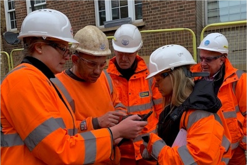
image of construction workers in high vis vests
Real world testing
- Immediate real world testing that was launched quickly with minimal bureaucracy proved crucial to maintain trust and buy-in, and provided feedback from end-users who often work in challenging situations such as emergency response and adverse weather conditions.
Keep the technology simple
- A simple, functional and well designed user interface is crucial to allow adequate user testing and feedback for any prototype.
- Technology is a key enabler but was not the critical success factor in the pilots. The focus was firmly on the stakeholders and processes dealing with underground asset data. The NUAR prototype platform is not a live service: this will be developed as part of a national roll out following an open and competitive tender process.
- The data model was based upon an international standard under development by the Open Geospatial Consortium (OGC) which informed our approach about bringing data together from disparate organisations and sectors into a common, harmonised structure. This harmonisation will be critical for long term success, and we will be refining the model to ensure it is extensible and allows data to be consistently used.
- A “one size fits all” system is unlikely to realise the full economic potential of a national platform. Its value could be maximised by allowing specialised services to be built upon the platform. This could be achieved by building flexibility of how services and data can be consumed.
Safety and security
- Although only intended as a prototype, the platform adopted a security-minded approach to the disclosure of asset information. Advice was sought from Centre for the Protection of National Infrastructure (CPNI), the National Cyber Security Centre (NCSC) to address national security and asset owners were consulted regarding their commercial and security concerns.
- A balance was needed between the need to protect data and to allow access which was done via a “secure by design” approach.
- Data sharing agreements were signed between all 35 public and private sector organisations participating in the pilot. This alignment of operational requirement and a risk-based legal approach has been a major milestone for the pilot project.
- During the pilots, asset owners continued to own, manage and take decisions on their own data, and any existing positions over liabilities remained the same. This principle is expected to continue through future phases of the programme.
The team
- We built the programme team around underground experts, experienced project managers, domain specialists and data experts described in this blog post.
- An international and diverse Advisory Group was created to give an independent challenge, to complement our Board.
- Close cooperation with Devolved Administration colleagues, the Scottish Road Works Commissioner, the Centre for Digital Built Britain, the National Infrastructure Commission and the Open Geospatial Consortium was essential to maintain credibility and avoid group-think.
- We have developed and maintained strong links with Project Iceberg which is an initiative between the Ordnance Survey and the British Geological Survey aiming to demonstrate the value of interoperable data about the subsurface. The project, which was initially supported by the Connected Places Catapult, now assists the NUAR team with the prioritisation and evaluation of further use cases and benefits of NUAR.
What are our next steps?
The National Underground Asset Register will continue to be a core part of the Geospatial Commission’s strategy. Over the summer we will be conducting additional work with utilities and local authorities in the North East of England and London to help refine our requirements for a national platform.
Engagement
To ensure a system is designed that is fit for purpose, user research is essential and we will continue to increase our engagement with asset owners and local authorities in the north east of England and London. We are particularly interested in reaching out to independent network and distribution providers as well as district heating operators to gain a deeper understanding of their data and willingness to participate in the current stage of work. If you fall into these categories and would like to be part of our engagement or you have any other queries please email geospatialcommission@cabinetoffice.gov.uk.
We plan to elicit feedback on our plans from future users of the platform and will also be conducting pre-market engagement prior to launching a competitive tender.
Acknowledgements
Our NUAR pilots would not have been possible without many key individuals and organisations who have worked tirelessly over decades to improve the knowledge of underground assets. The Geospatial Commission is truly grateful for their expertise, knowledge and friendly challenge to support what was set out to achieve in 2019.
Firstly, we want to thank our delivery partners the Greater London Authority and Ordnance Survey and all the underground asset owners who participated to maximise the value of geospatial data:
- Cadent,Camden Council,City of London,Community Fibre, Croydon Council,Darlington Borough Council Durham County Council, Environment Agency, Gateshead Council, Hartlepool Borough Council, Durham County Council, Environment Agency, Gateshead Council, Hartlepool Borough Council, Highways England, Historic England, HS2, National Grid, Network Rail, Newcastle City Council, Newham Council, Northern Gas Networks, Northern Powergrid, Northumbrian Water, Openreach, Redcar & Cleveland Borough Council, SES Water, SGN, South Tyneside Council,Southwark Council, Sunderland Council, Transport for London, Thames Water, Thames Water, Tower Hamlets Council, UK Power Networks,Virgin Media, Zayo
Finally, a big thank you goes to our advisory group, our ‘critical friends’ who also helped to ensure NUAR’s success by:
- Providing technical, legal, operational and academic advice and constructive input on progress.
- Representing stakeholder interests and avoiding groupthink.
- Using expertise and authority to assist the project in achieving its outcomes.
- Communicating constructively about the project in their organisations and beyond.
- Providing ad hoc pieces of research or input to surveys.
Organisations represented on the Advisory Group were:
British Geological Survey
Centre for Digital Built Britain
Chartered Institution of Civil Engineering Surveyors
Health and Safety Executive
Informatie Vlaanderen, Government of Flanders
Institution of Civil Engineers
Joint Authorities Group UK
Kent County Council
National Infrastructure Commission
Netherlands’ Cadastre, Land Registry and Mapping Agency
Open Geospatial Consortium
Ordnance Survey of Northern Ireland
Street Works UK
Transport Scotland
United Kingdom Onshore Pipeline Operators’ Association
University of Birmingham
University of Cambridge
University of Leeds
Utility Strike Avoidance Group
-
Cabinet Office, 2018 An Initial Analysis of the Potential Geospatial Economic Opportunity ↩
-
The Open Data Institute, The Data Spectrum ↩