Map the Gap (Phase 3): Competition Document
Updated 15 May 2026

© Crown copyright 2026
This publication is licensed under the terms of the Open Government Licence v3.0 except where otherwise stated. To view this licence, visit nationalarchives.gov.uk/doc/open-government-licence/version/3 or write to the Information Policy Team, The National Archives, Kew, London TW9 4DU, or email: psi@nationalarchives.gov.uk.
Where we have identified any third party copyright information you will need to obtain permission from the copyright holders concerned.
This publication is available at https://www.gov.uk/government/publications/map-the-gap-phase-3/map-the-gap-phase-3-competition-document
1. Introduction
This UK Defence Innovation (UKDI) competition is run on behalf of the Defence Science and Technology Laboratory (Dstl), in partnership with the British Army. It seeks innovative solutions capable of remotely assessing ground bearing capacity (GBC) and key wet‑gap (riverine) measurements, to support safe rapid land‑force mobility across wet gaps and other points of manoeuvre. Building on research conducted under previous ‘Map the Gap’ competitions, this competition aims to accelerate the development of novel sensing technologies deployable from uncrewed aerial vehicles (UAVs), to reduce risk to personnel while enabling rapid multi‑site survey.
Successful submissions will demonstrate a clear plan to a Technology Readiness Level (https://www.gov.uk/guidance/defence-and-security-accelerator-terms-and-conditions-and-contract-guidance) (TRL) 6 demonstrator (to be delivered in this competition); technology model or prototype demonstration in a relevant environment. Proposals will be judged against their ability to:
- conduct the survey at range (with a degree of autonomy)
- minimise the platforms observable signature
- output actionable information in an open and useable format that can be readily shared.
The total funding for this competition is £2.0m, with UKDI expecting to fund 3 to 4 proposals across both challenges for a contract period of up to 15 months.
2. Competition key information
| Key Information | Competition Details |
|---|---|
| Submission deadline | 12:00 Midday on 16 June 2026 (BST) |
| Total funding available | £2.0 million (excluding VAT) £1.0 million for each of 2 Challenge areas. A number of proposals may be funded under each Challenge. |
| Technology Readiness Level (TRL) | Ending at TRL 6 (Technology model or prototype demonstration in a relevant environment) |
| Contract start month | Aim to start October 2026 |
| Project duration | Equal to or less than 15 months. All projects must complete by end of January 2028 |
| Risk Assessment Reference (RAR) | RAR-FTZHWPY (Level 1 - Foundational) |
| Feedback release date | 14 August 2026 |
| Pre-sift criteria | See Section 9 for Pre-sift Criteria |
| Nationality | To be eligible to submit a proposal into this competition you must be a UK organisation registered at Companies House , based in the UK, (or a UK based Sole Trader) and plan to carry out the work in the UK. Your organisation does not need to be UK-owned. |
2.1 Competition Specific Requirements
Please note that this competition has specific deliverables as part of its pre-sift criteria. Only those proposals that demonstrate compliance with the UKDI pre-sift criteria will be taken forward to full assessment. For the full list of criteria, please see Section 9.
- Your proposal must include a single demonstration of the full system, as described in your concept of operation, in the list of deliverables.
- Your proposal must contain a deliverable of the final demonstrator, with code developed under the contract and instructions
- Your proposal must contain a final written report in the list of deliverables.
- Your proposal must include a reserve T&S item to cover attendance at the final demonstration site
- to be eligible to submit a proposal into this competition you must be a UK organisation registered at Companies House, based in the UK, (or a UK based Sole trader) and plan to carry out the work in the UK. Your organisation does not need to be UK-owned.
2.2 Where do I submit my proposal?
Via the UKDI Online Submission Service where you will need to register for an account. Only proposals submitted through the UKDI Online Submission Service will be accepted.
Innovators are strongly advised to submit their proposal at least one hour before the deadline. Proposals submitted close to the deadline risk encountering issues that cannot be resolved in time. Responsibility for timely submission rests entirely with the innovator, no extensions will be made. If you are having problems submitting your proposal, email us prior to the deadline on accelerator@dstl.gov.uk or call 01980 950000 option 3 Monday to Friday 0900-1200 only).
2.3 Public facing information
When submitting your proposal, you will be required to include a title, Proposal Value Proposition Statement (PVPS) and a short abstract. The title, PVPS and abstract you provide will be used by UKDI, and Partners Across Government (PAG), to describe your project and its intended outcomes and benefits. They may be included at UKDI events in relation to this competition and in documentation such as brochures. As this information can be shared, it should not contain information that may compromise Intellectual Property.
2.4 Further guidance
For further guidance on what to expect during the submission process and how your proposal will be assessed, please see the following GOV.UK pages and forms:
- Submit a proposal
- Assessment process and criteria
- UKDI: ethical, legal and regulatory guidance
- MODREC Guidance for Suppliers
- Competition Terms and Conditions
- UKDI contracting guidance
- Cyber Security Model
- How to get in touch with your local Innovation Partner
3. Supporting activities
3.1 Launch webinar
On 5 May 2026, UKDI hosted a launch webinar to provide more detail on the problem space and a chance to ask questions in an open forum. You can watch it below.
3.2 One-to-Ones
13 May 2026 – A series of 10 minute one-to-one teleconference sessions, giving you the opportunity to ask specific technical questions to the competition team in a closed forum. Registration for these sessions will be available the day after the launch webinar on 5 May 2026, on the Eventbrite page. Booking will be on a first come first served basis.
14 May 2026 - a further series of 10 minute one-to-one teleconference sessions. Please register for these sessions on the Eventbrite page. Booking will be on a first come first served basis.
Non-technical questions about the competition process should be sent to the UKDI Help Centre, accelerator@dstl.gov.uk.
3.3 Collaboration survey
We encourage collaboration between innovators for this competition. To support this, we have a short survey to collect details of those who wish to explore collaboration possibilities. If you are interested, please complete the collaboration survey.
The information (including personal details) you provide will be circulated among the innovators who have completed the survey. The sharing of details will only be done after an initial screening process has taken place, we reserve the right to not share all details.
All collaboration for proposal submissions is on an innovator-innovator basis. It is the innovators’ responsibility to determine the suitability of collaborators.
Inclusion or absence of collaboration will not affect assessment.
The final circulation of details will be 5 June 2026.
3.4 Innovation Outline
An innovation outline (IO) is a brief summary of your innovation that is used by the competition team to advise you whether your innovation is in scope for the competition.
If you’re unsure whether your idea is in scope, we strongly recommend you contact your local Innovation Partner via the Contact UKDI form. They will explore the suitability of your innovation for the competition and, if needed, advise you on submitting an IO, which must be submitted through the Submission Service.
To submit an IO:
- log in to the submission service
- select the service category UKDI Innovation Outline
- from the service name select Innovation Outline: Map the Gap (Phase 3)
- complete the form
Your local Innovation Partner will be able to advise you on the IO content.
Submission of an IO for this competition will allow socialisation of the idea across the competition team as appropriate, all elements of the IO will be shared. The competition team is made up of UKDI and Dstl staff. You should receive a response within two weeks, confirming whether or not your idea is in scope. The competition closes at 12:00 Midday on 16 June 2026 (BST). UKDI cannot guarantee a response to any IOs received after 2 June 2026.
All information you provide to us as part of your IO, that is not already available to us from other sources, will be handled in confidence. We will only share the information with those who can establish if your innovation is within scope of the competition. The information will only be used for the purposes for which it is provided to us. It won’t be used for other purposes, without us having obtained the necessary rights and permissions to do so.
Submitting an IO or speaking to your local innovation partner is not a mandatory criterion of this competition.
4. Competition scope
4.1 Background
Before British Land forces can cross a wet gap or negotiate unstable terrain, Royal Engineer reconnaissance teams must assess whether the ground and riverine environment are suitable for the safe passage of vehicles; whether specialist gap‑crossing equipment or the supported force. This terrain assessment relies on a series of measurements that together provide a holistic understanding of terrain accessibility, stability, and suitability for military vehicles.
Currently, these measurements are taken in person. This method is slow, exposes soldiers to danger at the forward edge of the battlefield, and risks compromising the concealment of potential crossing or manoeuvre sites by signalling interest through the deployment of engineering equipment. Decreasing the time taken to survey a potential crossing point enables more crossing sites to be assessed, increases the pace of decision making and the survivability of the supported force.
The wet gap crossing survey comprises a measurement set that can be used in a range of manoeuvres, and is illustrated in figure 1.
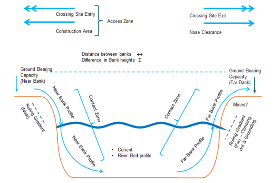
Wet gap crossing cross section with annotations describing the measurement requirements.
Figure 1 – Wet gap crossing cross section with annotations describing the measurement requirements.
This competition builds on lessons learned under the previous DASA competition “Map the Gap”, which demonstrated clear potential for remote and autonomous systems to reduce risk to personnel. It highlighted the need for improved approaches to fused sensing, data quality, environmental resilience, and a focus on UAS deployed payloads.
Previous competition phases showed that no single unmanned platform, whether ground, surface or air, could deliver a full high fidelity wet gap survey. Each exhibited different limitations in coverage, mobility and autonomy. Trials highlighted the need for water contacting sensors for high-resolution underwater profiling, given penetration limits of bathymetric LiDAR in turbid conditions, and for robust UAS deployable sensors to estimate ground bearing capacity (GBC) across multiple sites. They also demonstrated the value of modular, platform agnostic sensor packages that can be rapidly remounted when platforms fail or when missions require only part of the full survey.
The MOD requires a faster, safer and less detectable way to generate these critical measurements. Sensing technologies that can operate autonomously or semi‑autonomously at range and under a variety of environmental conditions have the potential to significantly improve mobility planning while removing soldiers from harm’s way. Increasing the pace, stealth and number of viable crossing sites will increase operational agility and obfuscate tactical intent.
The primary exploitation route for this technology will be British Army Engineers operating in a manoeuvre support role across multiple use cases. It will ultimately form part of a wider Engineering Recce capability.
This capability (if successful) would potentially stir interest across the international Military Engineering community. There is potential application to other sectors that require rapid GBC assessment or in areas difficult to access. That could include humanitarian aid in post disaster zones.
4.2 Scope
This competition seeks proposals to develop systems toward two primary challenges.
- Measurement of Ground Bearing Capacity (GBC) from an Uncrewed Aerial System (UAS).
- Underwater river profiling from UAS deployed sensors or payloads.
Both must be delivered through a system of systems (SoS) approach that combines sensors, autonomy, and modular integration, allowing operators to select only the sensor payloads required for a task, and to operate at range, noting that the expectation for final deployment is to operate at a range of ca. 3km to 5km. This modularity enables the operator to minimise platform signature and tailor size weight and power (SWaP) to mission needs.
Although the competition focuses on wet gap and GBC measurement, proposals that can evolve toward wider engineering reconnaissance tasks are encouraged. The Ministry of Defence (MOD) is particularly interested in interoperable, open architecture subsystems suitable for integration with alternative platforms, ground control stations and in service systems.
The competition will culminate in a TRL 6 system demonstration to relevant stakeholders across the MOD. We intend to provide a suitable MOD site, in the UK, at which the demonstration will be undertaken. We ask innovators to supply as much information as possible in their proposal to allow us to determine appropriate sites (operating parameters, licensing, particular HSE requirements etc.) It is appreciated that not all of this will be known at the proposal stage but should be determined during the early stages of any awarded contract. Each successful bidder will be assigned a Dstl Technical Partner to support development, attend testing, and facilitate engagement with end users. Bidders should plan for regular monthly meetings with the Technical Partner and wider Dstl project team.
Example scenario:
The Army must cross a wide river (>50m width) as part of an advance and must identify viable crossing points. Maps are used to preselect multiple candidate crossing points and a gap crossing survey is initiated from beyond visual line of sight; several kilometres before the gap. The area may have degraded or denied access to global navigation satellite system (GNSS). The survey will:
- move autonomously to the candidate crossing points, at least 3 different points spaced across a 5km frontage.
- measure the gap characteristics described in figure 1. Measure across a length of river bank up to 16m in length.
- have the option to either transmit survey information live or post-processed, to provide a trade between pace and signature management.
- offer a trade between full survey and pace (partial survey).
- return to a location designated by the operator.
The commander will use this survey to determine viable crossing points.
The above scenario is illustrative of a wet gap crossing, though the system could be utilised for combat bridging and other gap crossing or manoeuvre operations. This scenario should form the basis of the final demonstration. Whilst the proposal should evidence the potential for the system to cover the frontage described above, concessions will be made to reduce the flight envelope for the demonstration.
4.3 Exploitation
At the conclusion of the contract, ownership of the demonstrator will transfer fully to the Ministry of Defence (MOD) not impacting the Intellectual property rights under the terms and conditions of DEFCON 705. Following this transfer, the MOD intends to undertake additional trials beyond the scope of the original contract. Activities to support this post‑contract work will be determined at the end of the contract. This experimentation will form a crucial next step in understanding requirements for integration to other MOD systems, trade-offs between platform SWaP and endurance, and wider training and doctrinal needs.
We would be interested to understand the level of post contract support you would be able to offer (without commitment) so that next steps can be considered.
To support this next stage of requirement capture, an open design approach is requested.
Desirably, all parts of the system e.g. sensors, data formats, processing pipelines, and platform interfaces should be fully open, documented, and free from proprietary restrictions that would limit MOD’s ability to inspect, modify, or integrate the solution. Sensors should provide access to raw data and operate through open digital interfaces, using non‑proprietary formats with complete metadata. Modelling approaches should be transparent and reproducible. All platform‑side integration should be compatible with open UAV standards such as MAVLink. Systems that interface with Team Awareness Kit (TAK) are of interest.
All proposals to UKDI should articulate the expected development in technology maturity of the potential solution over the lifetime of the contract and how this relates to improved operational capability against the current known (or presumed) baseline. Your deliverables should be designed to evidence these aspects with the aim of making it as easy as possible for potential collaborators/ stakeholders to identify the innovative elements of your proposal in order to consider routes for exploitation. UKDI Innovation Partners are available to support you with defence and security context.
As requested in Section 6, details of any expected licensing fees, including potential longer term fee commitments should be described in your initial proposal as this could impact any potential longer term exploitation plans.
This competition is being carried out as part of a wider MOD programme and with cognisance of cross-Government initiatives. We are also investigating collaboration with several international organisations and this may provide the opportunity to carry out future international trials and demonstrations and additional routes for exploitation.
The above collaboration comments only apply to the outcome of funded projects. Proposals submitted into the competition will only be reviewed by Dstl and MOD experts.
5. Competition challenges
This aim of this competition is to produce a system capable of taking measurements to inform the potential crossing of a wet gap obstacle. Focus has been given to a wet gap crossing recce, as this is deemed particularly challenging. Submissions must address one or both of the competition challenges, providing a technical solution and a concept of operation (ConOp) relevant to the example scenario above.
The key activities of the above scenario have been split across two overarching challenges with sub-challenges outlined underneath. Proposals may be submitted against challenge 1 and/or challenge 2. If pursuing a single system approach that answers both challenges, innovators should explain clearly in their ConOp, the benefits of this over two separate systems - giving consideration to SWaP, signature, loiter time and other logistical parameters. If both challenge areas are being addressed using separate systems then please submit two separate proposals.
Sub-challenges marked as essential must be met, sub-challenges marked as desirable are requested but not required.
5.1 Challenge 1: Estimation of Ground Bearing Capacity from an Uncrewed Aerial System
This challenge is focused on beyond line of sight determination of Ground Bearing Capacity on the banks of a wet gap crossing and, desirably, the crossing bed. Measurements up to 350 kPa ± 50kPa should be expected. It is expected that candidate technologies and techniques will be low TRL and this competition will focus on development of these and the underlying models.
Additional above water gap measurements are required as part of this challenge and are listed as essential. Solutions should be capable of gathering these measures across wet gaps up to 300 metres wide (an in-service capability may be required to measure further). An explanation of the current handheld method for estimating ground bearing capacity using a cone penetrometer is provided in Appendix A.
The ConOp must detail how the burden on the operator is reduced at each stage of the operation and where technologies are used to achieve this.
Solutions must have the potential to collect measurements across a wide range of environmental conditions. Considerations include but are not limited to
- maritime (coastal),
- ground conditions (mangrove swamp, silty river beds, rocky uneven river beds, snow),
- river access (steep banks, reeds, fast flowing water),
- lighting (day/night),
- weather (fog, windy),
- obstacles (trees, underwater obstacles, floating trees / detritus).
- GNSS denied.
Essential measurements for Ground Bearing Capacity:
- surface only near and far bank ground bearing capacity estimates:
- minimum of 3 measurements per bank
- just above the water level
- on the top of the bank
- the run-in to the bank. Averages at each point may be necessary.
- repeated for at least two distinct crossing points – the more the better.
- minimum of 3 measurements per bank
Essential measurements above water:
- near and far bank height profile - spanning near to far bank and including the water profile. This should run from 8 meters inland from the water’s edge on each bank and span 16m along the riverbank; e.g. for a 100m wet gap this would generate a height profile over an area of 116m x 16m.
- gap width between banks to a tolerance of ±50 mm.
- difference in bank heights to a tolerance of ±20 mm.
Essential for Autonomy Aspect:
- autonomy enabling technologies must be exploited to reduce operator burden. The concept of operation must detail how operator workload is reduced at each phase of the operation, identifying where autonomy or automation is employed to achieve this.
- obfuscation of solution intent must be considered throughout all stages of the operation (detail this in your concept of operation). Examples of obfuscation include but are not limited to
- minimising EM signature
- inability to pinpoint objective survey or crossing location.
- information must be presented in a user-friendly format. An example of this could include presenting a high-level view of the key recce metrics in a simple form to the commander with more detailed data available to the amphibious bridging commander.
- proposals must address how solutions can overcome any vulnerabilities inherent to the platform and sensor technology utilised.
Desirable measurements:
- near and far bank ground bearing capacity estimates graded by depth up to 600mm.
- ground bearing capacity estimates across the full 16m bank width on the near and far bank, from the lead-in to the water’s edge.
- below water, riverbed ground bearing capacity estimates.
- riverbed profile indicating layers and materials.
- full width river profile.
- surface water flow rate.
5.2 Challenge 2: Riverine gap‑crossing assessment from an Uncrewed Aerial System
This challenge invites concepts that can deliver high resolution below water mapping to a depth of at least 3m, in turbidity of greater than 10FNU (Formazin Nephelometric Units) and flow rates of up to 3m s⁻¹. Additional above water gap measurements are required as part of this challenge and are listed as essential.
Sensor payloads must be transported to the water by UAV; concepts may include underslung water contacting sensors and or secondary unmanned vehicles deployed by UAV. Solutions should be capable of gathering these measures across wet gaps up to 300 metres wide (an in-service capability may be required to measure further).
Solutions must have the potential to collect measurements across a wide range of environmental conditions. Considerations include but are not limited to
- maritime (coastal),
- ground conditions (mangrove swamp, silty river beds, rocky uneven river beds, snow),
- river access (steep banks, reeds, fast flowing water),
- lighting (day/night),
- weather (fog, windy),
- obstacles (trees, underwater obstacles, floating trees / detritus).
- GNSS denied.
Essential above water:
- a 16 metres wide (minimum) bank height profile of the near and far bank contact zone (shown in Figure 1), encompassing 2 metres below minimum water line and 8 metres inland of the bank edge.
- gap width between banks to a tolerance of ±50 mm.
- difference in bank heights to a tolerance of ±20 mm.
Essential below water:
- high resolution subsurface mapping survey to a depth of at least 3m, across a bank width of 16m (Turbidity of greater than 10FNU).
- detect objects or obstacles of at least 30cm diameter (ideally smaller) to a water depth of 2m (minimum).
- water flow rate estimation at the surface and at least one other depth greater than 30cm.
Desirable:
- detection of mines (water and land variants).
Essential for Autonomy Aspect
- autonomy enabling technologies must be exploited to reduce operator burden. The concept of operation must detail how operator workload is reduced at each phase of the operation, identifying where autonomy or automation is employed to achieve this.
- obfuscation of solution intent must be considered throughout all stages of the operation (detail this in your concept of operation). Examples of obfuscation include but are not limited to
- minimising EM signature
- inability to pinpoint objective survey or crossing location.
- information must be presented in a user-friendly format. An example of this could include presenting a high-level view of the key recce metrics in a simple form to the commander with more detailed data available to the amphibious bridging commander.
- proposals must address how solutions can overcome any vulnerabilities inherent to the platform and sensor technology utilised.
- solutions must also enable seamless integration of above‑bank, below‑bank, and river‑bed profiling to provide a coherent and continuous representation of the crossing environment.
5.3 We are interested in…
We want novel ideas to benefit end-users working in UK defence and security. Your proposal should include evidence of:
What we want to see from a proposal
- UAS deployed concepts that can operate beyond line of sight; whether single platform or teamed, with mounted or dropped payloads.
- Proposals must be evidence-based and sensor focused placing the generation of actionable measurements at the centre of the solution.
- Proposals should avoid “bolt‑on AI” solutions; data and model transparency is required for full insight into how measurements are generated.
- Concepts that allow for multiple sight surveys without reload/reset - the more the better.
- Novel sensing concepts (or novel combinations of existing concepts).
- An open and modular approach to all parts of the system design to support experimentation, including access to raw data, physical interfaces, open flight control software.
- A project roadmap that defines in detail all stages of the project, including: data collection; algorithm development; measurement validation; platform integration and pre-trial testing.
The output of the funded project should be a technology demonstrator at TRL 6, of a system that can take multiple ground bearing capacity measurements or multiple riverine gap measurements, at user specified locations, beyond visual line of site of the operator. This includes:
- semi-autonomous/remote tasking of an unpiloted platform to multiple user specified locations, with an integrated sensing payload.
- demonstration of the suitability of the sensing payload to take measurements, validated against standard tests, at multiple locations.
- end to end demonstration of the platform tasking, GBC/riverine measurements at multiple sites, platform recovery and information output in a relevant format. We would expect to see options for both data processing on board and post-processing after flight.
5.4 We are not interested in
We are not interested in
- Systems that are not recovered from the site in normal operation and/or offer single site survey.
- Constitute consultancy, paper-based studies or literature reviews which summarise the existing literature without any view of future innovation.
- Offer demonstrations of off-the-shelf products requiring no experimental development (unless applied in a novel way to the challenge).
- Systems that offer no real long-term prospect of integration into defence and security capabilities.
- Rely solely on manual operator deployment.
- Use of survey techniques requiring heavy ground contacting equipment unsuitable for UASs.
- ‘Black‑box’ systems lacking explainability or without access to model internals.
- Prioritisation of existing commercial UAV capability over development of the underlying sensing concept.
6. Critical elements to include
When writing your proposal, ensure you have:
- focused on the Phase 3 requirements but also included a brief (un-costed) outline of the next stages of work required for future exploitation
- included a list of other government funding you have received in this area. Making it clear how this proposal differs from that work
- included a detailed project plan with clear milestones and deliverables. Deliverables need to be well defined and designed to provide evidence of progress against the project plan. Your deliverables must include a written final report and technology demonstrator. The final deliverables must be completed no later than early January 2028.
- planned (and costed) attendance at the following meetings, which will all be in the UK.
- a kick-off meeting at the start of Phase 3
- an end of project demonstration event (intended for end of November or beginning of December 2027). You must include a ringfenced finance item for Travel and Subsistence of £5000 to cover the cost of the demonstration. Actual costs shall be reimbursed provided that they are deemed reasonable.
- regular monthly reviews with the appointed Technical Partner and Project Manager
- close down meeting at the end of the project
- included details of any licensing fees, including potential longer term fee commitments.
- identified any leased or rented components used in your final demonstrator that will not be not part of final demonstrator deliverable and transferred to MOD Ownership
Other than the demonstration, these activities may take place virtually. Slides presented at these meetings should be appropriately marked and made available
- identified any ethical / legal / regulatory factors. Associated risks should have been added to the Risk Register in Step 5 of the submission service along with details of how they will be managed, including break points in the project if approvals are not received
- included any requirements for access to Government Furnished X (GFX). GFX is the preferred nondescript term for anything that the Government provides in which the ‘X’ could be artefacts such as information or equipment. UKDI cannot guarantee that GFX will be made available. You should have included an alternative plan in your proposal in case it is not available.
7. Regulatory Considerations
Given the nature of the work we would like to ensure that innovators have considered any regulatory matters relating to their proposal. During the submission process you will be asked to confirm if your proposal will be affected by any of the regulations below and how it may be impacted.
7.1 Investigatory Powers Act
Please confirm:
- How instrumentation and spectrum monitoring (if any) during tests and demonstrations would be managed? Specifically, is there an intention to collect raw RF (IQ data) as part of safety or effects monitoring. If there is intention to collect (even fleetingly) in the communications or Industrial, Scientific and Medical (ISM) frequency bands, there may be a minor risk under Investigatory Powers or linked legislation that MOD will need to assist with.
- What is the plan to manage risk involving RF transmissions (including bespoke encrypted WiFi). Assistance may be needed with legal permissions, licensing or advice on spectrum deconfliction if there is any risk of interfering with communications that are not specifically co-operating in trials. We would need assurance that you are sufficiently managing safety and legal risk.
- Would cameras or other devices that may unintentionally intrude on non-participants of your experiments be used? Advice on risk mitigation may be required, depending on your risk of intrusion
7.2 CAA Regulations and Licensing
If drones are to be used confirm the CAA category for each drone and whether licences are in place or will need to be obtained.
7.3 RF Transmissions
Please confirm awareness of the need to comply with the Wireless Telegraphy Act. If it is believed that the licensing exemptions will apply please confirm under which section and that the corresponding operating criteria will be complied with.
7.4 Explosives
Please highlight and list any Explosive[footnote 1] to be used along with method of employment and whether any changes will be made to such item(s) where they have been bought off the shelf
8. Accelerating and exploiting your innovation
Ensure your deliverables are designed with the aim of making it as easy as possible for assessors to recognise expected development in technology maturity of the potential solution over the lifetime of the project. Specifically, how this demonstrates improved capability against the current known (or presumed) solutions.
Over the lifetime of UKDI awarded projects, ideas may mature and accelerate under the guidance of appropriate stakeholders, toward being functional capabilities. How long this takes, and how far towards a deployable capability the innovations progress, will depend on any future exploitation after the completion of the UKDI project.
Low TRL research and development may not be able to articulate exploitation in great detail, but it should be clear that there is credible advantage to be gained from the technology development.
8.1 Exploitation beyond your project plan
Include the following information within the Desirability question within the UKDI Online Submission Service application form to help the assessors understand your exploitation intentions:
- expected additional work required beyond the end of the contract to develop an operationally deployable commercial product (for example, “scaling up” for manufacture, cyber security, integration with existing technologies, environmental operating conditions)
- additional future applications and wider markets for exploitation
- wider collaborations and networks you have already developed or any additional relationships you see as a requirement to support exploitation
- how your product could be tested in a representative environment in later phases
- any specific legal, ethical, commercial or regulatory considerations for exploitation
- potential Licensing costs
9. Pre-sift Criteria
Before your proposal is assessed, all proposals will be checked for compliance with the UKDI pre-sift criteria. Proposals will be rejected before full assessment if they do not comply.
For more information on how your proposal will be assessed please read Assessment process and criteria.
Map the Gap (Phase 3) pre-sift criteria are as follows:
| Criteria | Measure - Within scope (Pass) / Out of scope (Fail) |
|---|---|
| The proposal outlines how it meets the scope of the competition | Pass / Fail |
| The proposal explains how it meets the UKDI criteria (Desirability, Feasibility, and Viability) in the relevant questions in Step 3 of the submission service | Pass / Fail |
| The proposal must contain a financial plan, a project plan and a resourcing plan which demonstrate how the work proposed will be completed | Pass / Fail |
| The Finance Items must include a ringfenced amount of £5000 to cover Travel and Subsistence for the final demonstration event | Pass / Fail |
| The delivery schedule within your proposal includes evidence of a written final report | Pass / Fail |
| The delivery schedule within your proposal includes evidence of a practical demonstration | Pass / Fail |
| Final deliverable is at TRL6 | Pass / Fail |
| Maximum value of proposal is £500,000 | Pass / Fail |
| The final deliverable month indicated must be less than or equal to 15 months from T0 where T0 is the project start date agreed by both parties. In all cases projects must complete by the end of January 2028 | Pass / Fail |
| The submitting organisation is a UK registered company and the majority of work is to be completed in UK | Pass / Fail |
| The proposal does not contain attachments that have been used for additional text data over the stated word counts in Desirability, Feasibility, Viability and Additional Information | Pass / Fail |
| If the proposal is a resubmission of a previous one, it adheres to the resubmission guidelines | Pass / Fail |
10. How your proposal will be assessed
Proposals that are compliant will be assessed against the standard UKDI assessment criteria (Desirability, Feasibility and Viability) by subject matter experts from the MOD (including Dstl), PAG and the front-line military commands. You will not have the opportunity to view or comment on assessors’ recommendations.
UKDI reserves the right to disclose on a confidential basis any information it receives from innovators during the procurement process, which includes the full proposal, to any third party engaged by UKDI for the specific purpose of evaluating or assisting UKDI in the evaluation of your proposal. In providing such information you consent to such disclosure. Appropriate confidentiality agreements will be put in place.
After assessment, proposals will be discussed at a Decision Conference where funding decisions are made based on the assessments, budget and wider strategic considerations.
Innovators are not permitted to attend the Decision Conference.
11. UKDI Terms and Conditions
Please read the UKDI Contracting Guidance which contain important information for innovators. For this competition we will be using the Innovation Standard Contract (ISC) Terms and Conditions. The Intellectual property rights condition for this contract is DEFCON705. Information on the relevant DEFCONs can be found by registering on the Knowledge in Defence site.
We require unqualified acceptance of the competition Terms and Conditions. Where innovator organisations have a commercial department they will need to provide acceptance.
We will use deliverables from UKDI contracts in accordance with our rights detailed in the contract Terms and Conditions. This includes sharing deliverables with members of the Five Eyes community under the Five Points Memorandum Of Understanding (MOU).
11.1 Feedback
Proposals that are unsuccessful will receive feedback in the form of bullet points and a couple of short paragraphs after the Decision Conference.
Where a proposal meets the fundable requirements for a competition, but is not funded, UKDI will continue to seek funding and shall consider your proposal fundable for 12 months from the date of the feedback release.
We will share the abstract, Proposal Value Proposition Statement (PVPS) and title of your proposal with partners across His Majesty’s Government that may express an interest in funding the proposal through UKDI, in accordance with the competition document. We may also share this information on our cross-government Ideas Marketplace platform to foster collaboration and attempt to elicit funding. If partners across His Majesty’s Government wish to read the full proposal to decide if they will fund it, we will share the full proposal with them without seeking your permission if it is within 60 days of the feedback release date. If it is over 60 days since the feedback release date we will seek your permission before sharing the full proposal with them.
For other potential funders, we will seek your permission before sharing the full proposal regardless of the number of days since the feedback release date.
In the event that funding becomes available, UKDI may ask whether you would still be prepared to undertake the work outlined in your proposal under the same terms. Your official UKDI feedback will indicate if your proposal was deemed fundable, but not awarded funding at the time.
12. If your proposal is recommended for funding
Funded projects will be allocated a Project Manager (to monitor the project) and a Technical Partner (as a technical point of contact). In addition, the UKDI team may work with an innovator to support delivery and exploitation including, when appropriate, introductions to end-users and business support to help develop their business.
12.1 Cyber Security Model
The Cyber Security Model (CSM) is how Defence builds cyber security into its supply chain.
On receipt of a FUND decision, successful innovators (and their sub-contractors) must prove cyber resilience before the contract is awarded. The start of this process is the submission of a Supplier Assurance Questionnaire (SAQ). The SAQ allows innovators to demonstrate compliance with the specified risk level and the corresponding profile in Def Stan 05-138, and the level of control required will depend on this risk level.
To expedite the contracting time of successful innovators we ask all innovators to complete the SAQ before they submit their proposal (this is not mandated). The SAQ must be completed using the Risk Assessment number RAR-FTZHWPY.
The SAQ will be automatically scored against the Cyber Risk Profile (CRP) and you will be immediately informed of the outcome, compliant or not compliant.
If non-compliant, you will be required to complete a Cyber Improvement Plan (CIP) before the contract is placed which will need to be reviewed and agreed with the relevant project manager. The CIP template can be found here.
Before you start your SAQ you will need:
- the Risk Assessment Reference (RAR) RAR-FTZHWPY
- a D-U-N-S number (a unique identifier for your organisation)
- a GOV.UK One Login
12.2 Export control for overseas partners
All relevant export control regulations will apply if a company ultimately wants to sell a developed solution to a foreign entity. All innovators must ensure that they can obtain, if required, the necessary export licences for their proposals and developments, such that they can be supplied to the UK and other countries. If you cannot confirm you can obtain the necessary licences as part of your proposal, you will be required to provide this information prior to contract award, should your proposal be selected for funding.
13. Points of Contact
During the competition phase all correspondence must be via the UKDI Points of Contact detailed below.
While all reasonable efforts will be made to answer queries, UKDI reserves the right to impose management controls if volumes of queries restrict fair access of information to all potential innovators.
13.1 Innovation Partner
UKDI has a team of locally based Innovation Partners that can provide support in working with UKDI. It is strongly recommended that you contact your local Innovation Partner to discuss your idea for any aspect of this competition.
You can initiate this through the submission of a Contact UKDI Form by following instructions on the Contact a UKDI Innovation Partner page if you do not already have an established relationship with your local Innovation Partner.
13.2 UKDI Help Centre
Competition queries including on process, application, commercial, technical and intellectual property aspects should be sent to the UKDI Help Centre at accelerator@dstl.gov.uk, quoting the competition title. UKDI cannot guarantee a response to a query after the 26 May 2026, 3 weeks before the competitions closes.
14. Appendix A
14.1 Guide – Cone Penetrometer Use
This guide describes the use of the static cone penetrometer (SCP) measurements tool. The lightweight tool is used by British Land Forces to measure in-depth resistance to penetration, using the California Bearing Ratio (CBR) or Cone Index (CI) value. The SCP approach uses a continuous, constant force to push the cone into the ground to a depth of up to 600mm.
The tool consists of a metal housing containing a calibrated compression spring, operating shaft and dials and folding handles attached to the side. CBR/CI cones are attached via an extension rod screw at the end of the operating shaft.
After assembly and before use, the operator ensures that the SCP is calibrated (12 monthly) and has a zero reading on the dial. Non-zero readings can be zeroed out using an adjustment screw prior to measurements.
Measurement procedure:
- Grip the instrument firmly by the handles, steadying the forearms against the thighs to enable bodyweight advantage.
- Keeping the instrument vertical to avoid fouling in the shaft, apply a downward force to the handles to create a steady downward movement.
- Stop and read the dial when the top of the cone is flush with the ground surface.
- Continue to push the cone down at a steady rate of approximately 25mm per second, pausing and taking successive readings at 75mm intervals.
- Take a mean value by repeating measurements in the local area at least 3 times. If measurements are impeded by rocks, move and repeat.
14.2 California Bearing Ratio
California bearing ratio (CBR) is a ratio (expressed as a percentage) that describes the relative force required to penetrate a soil sample with a cone, compared to that required to penetrate a known material – typically crushed stone.

The CBR is a commonly used test when evaluating the strength of soils and base materials in civil engineering, including ground bearing capacity. An alternative to the CBR is the Cone Index (CI) value, which is an absolute measure of the penetration of a sample; usually given in tonnes/m2 or kPa.
15. Q&As
This section covers the questions and answers collected from the Launch Webinar (5 May 2026) and one-to-one sessions (13 and 14 May 2026).
15.1 TECHNICAL
Q: There are several essential requirements listed. If we cannot precisely meet all of these will our bid be disqualified?
A: We have mentioned these factors as the expected operational requirements. Phases 1 and 2 looked at individual approaches to obtaining these data and Phase 3 requires that all data are brought together to ease the burden of reviewing multiple sites. All proposals should provide data on all the essential elements. However, if you can meet most parameters and get close to the target on others we would still like to see your proposal. The assessment would reflect that not all target parameters will be met. The bids will be reviewed holisitically so a particularly strong performance in one area may still be of interest even if other areas fall under the indicated parameters.
Q: How deep does river profiling need to go? What width are we considering?
A: The desired parameters are listed in Section 5 of the Competition Document..
Q: Is there interest in littoral aspect of gap crossing?
A: This is not the main focus of the competition but there would be interest from the littoral community for beach reconnaissance. However, for this competition you should focus on gap crossings.
Q: Should we limit our system to look at static objects or are moving objects of interest as well?
A: Static objects are more important. The information will not be used in real time so moving objects may not be present at time of crossing. Having an indication of potential surface debris may be of interest. If using a tethered system identifying moving objects could be beneficial to prevent entanglement.
Q: What is UKDI’s position on the use of tethered UAV or underwater drones?
A: We have no strong feelings on this. If you believe you have a system that can make the required measurements then we would like to see your idea.
Q: Are you open to the use of piloted unmanned ground vehicles to deliver a river gap assessment tool?
A: Yes. You would have to explain how you would get them to the required locations in an appropriate timeframe.
Q: How far away should the operator be?
A: An expected operational distance would be several kilometres. You should describe any limitations in your proposal. See the demonstration clarifications below regarding expectations for the trial.
Q: Are you interested in Challenge 1 bids for mine detection alone?
A: No For Challenge 1 bids there must be an assessment of Ground Bearing Capacity
Q: Is Water chemistry, along with mapping data of interest?
A: If your system can provide information on water chemistry, without negatively impacting other measurements that may be of interest. However, decision about the potential crossing site will most likely be made several hours after the measurement so transient water chemistry measurements would not necessary remain relevant.
Q: How long should we spend to make measurements?
A: The expectation is that a number of sites could be surveyed in a few hours. Allowing for travelling between the sites we would expect individual site assessments to take no more than 10 to 15 minutes.
Q: Is there any preference between accuracy and usability?
A: Both are important and they are really complimentary. The assessment of your proposal will probably reflect the minimum of the two.
Q: You mention that you are looking to minimise EM signature. Can you explain this element a little more?
A: This aspect is related to the command and comms links, not necessarily any EM signals required to make the measurements.
15.2 COMMERCIAL
Q: Is there a limit to the number of proposals funded under this phase? What is the proposal cost cap?
A: The budget for the competition is £1 million per challenge. We are expecting to fund around 3 proposals under each challenge but might fund fewer should an exceptional proposal be received. If you are covering both challenge areas in a single proposal the proposal cap is £2 million
Q: If I bid make 2 separate bids (1 for each Challenge) and I am successful in both will both be funded in full?
A: We reserve the right to request cost reductions for any development work undertaken that is common to both proposals. We are not permitted to pay twice for the same piece of work
Q: The lead company must be UK based and the work undertaken in the UK. What are the considerations around overseas component supply and use of overseas sub-contractors?
A: We are looking to support work that predominantly adds value to the UK economy. The draft Terms and Conditions identify specific nationalities of concern and actions required in setting up sub-contracts. If there is a compelling case to use overseas components or sub contractors please describe in your proposal. Security checks will be made on subcontractors before the award of a contract
Q: What level of instruction/training/guidance on using the equipment will be required?
A: We would expect to receive operational instructions for your system such that a non-expert soldier can use the system and obtain data. Additional training and guidance post the demonstration would be negotiated separately. We would like you to mention in your proposal your willingness to enter into such a relationship post contract.
Q: Do I have to provide the actual demonstrated system?
A: It is a requirement of the competition to deliver a prototype system and operating instructions. This is to permit further testing after the Map the Gap competition with the aim of developing into a full capability. See Sections 4.3 and 8 for further information regarding future exploitation beyond the project. Additional equipment not paid for during the project can be used to supplement the demonstration and may be retained if not key to the operation of the prototype.
Q: As we are transferring ownership of the demonstrator after the project does it require CE certification?
A: No. we will acquire the equipment as seen.
15.3 REGULATORY
Q: Can UAV operations be run under CAA regulations?
A: Please identify in your submission, using the appropriate question, the characteristics which will help us to determine which category and regulations will apply including details on:
- weight of the system;
- system(s) tethered to the ground?
- dimensions if over 3m
- carriage of dangerous goods
- will items be intentionally dropped – if so
- will the dropped item be tethered to the UAS).
- will it be possible to control the drop i.e. withdrawing it back to the system and lowering again
- will the item be placed or is there a drop (no matter how small)
- intended flight height if above120m
- if a swarm operation, numbers involved and can all UAS within the swarm be manually over-ridden to return?
Note that BVLOS does not need to be demonstrated but evidence of this ability should be evidenced.
Final decision on category and regulations that apply will only be confirmed once full details of the system and the demonstration site are known.
Q: Can we get MOD sponsorship for MAA regulations?
A: Discussions would be required about which Regulations apply for the demonstration. If MAA Regs need to be followed then it is likely that we would sponsor this. Please make it clear in the proposal what aspects are likely to mean that MAA Regulations will apply.
Q: Are there any limitations about use of laser light?
A: Activities required for the demonstration will have to be performed safely. If you require lasers operating at a wavelength or power that fall into Classes 3 or 4 then full risk assessments and safety measures, acceptable to the trials manager, will be required.
15.4 DEMONSTRATION EVENT
Q: Will you require Beyond Visual line of Sight/GNSS denied operation for the demonstration?
A: It is not intended that the demonstration event will require BVLOS or GNSS denied operation. However, we would expect to see during the development project evidence that your system has the capability to operate under these conditions.
Q: Is there any chance that the trial site will be outside of the UK?
A: The site has not been selected but we are not currently exploring sites outside of the UK. Successful projects will be provided with details about the site as soon as possible once they are on contract. We will support contractors to ensure they meet the requirements.
Q: Will a map of the trial site be provided?
A: It is planned to provide a map but the level of detail cannot be stated at the moment.
Q: Does every proposal have to include a demonstration?
A: We need to understand the full potential of your technology and see a real world demonstration. If you do not have expertise in UAS platforms but some interesting sensor technology that could be demonstrated from a mast/crane we suggest you use the collaboration survey to identify potential partners with the required expertise or failing that clearly explain in your proposal how your technology could be attached to a UAS platform.
Q: Will it be possible to have access to the trial site, or a back-up site, during the project that teams can book for de-risking purposes?
A: This will not be possible. You should identify any potential risks in your submission and describe mitigating actions.
Q: How many systems are needed at the demonstration?
A: You should provide sufficient equipment to demonstrate that your concept works.
15.5 GENERAL
Q: When is the outcome of the Collaboration survey released?
A: The collaboration survey runs until June 5. All who sign up will receive a copy of the spreadsheet weekly until June 5. UKDI does not offer a brokering service and organisations should make their own links based in the information provided.
Q: Will details of approaches taken in Phase1 and 2 be made available?
A: We are not able to share information about the previous contracts.
-
Explosive: A substance (or a mixture of substances), which is capable by chemical reaction of producing gas at such a temperature and pressure as to cause damage to the surroundings. A substance manufactured with a view to producing a practical effect by explosion or pyrotechnic effect.
Notes:
(1) The term explosive material includes solid and liquid high explosives, propellants and pyrotechnics.
(2) It also includes pyrotechnic substances even when they do not evolve gases.
(3) The term ‘explosive’ is often used in short for ‘explosive material’.
(4) An explosive atmosphere of gas, vapour or dust is not considered to be an explosive.
(5) the definition of Explosives extends to novel materials designed to create an explosive effect. Examples: propellants, energetic material, igniter, primer, initiatory and pyrotechnics irrespective of whether they evolve gases ↩