Guidance to help inform when an upland breeding wader survey is needed and when woodland creation is likely to be appropriate
Updated 19 April 2024
Applies to England

© Crown copyright 2024
This publication is licensed under the terms of the Open Government Licence v3.0 except where otherwise stated. To view this licence, visit nationalarchives.gov.uk/doc/open-government-licence/version/3 or write to the Information Policy Team, The National Archives, Kew, London TW9 4DU, or email: psi@nationalarchives.gov.uk.
Where we have identified any third party copyright information you will need to obtain permission from the copyright holders concerned.
This publication is available at https://www.gov.uk/government/publications/guidance-for-afforestation-proposed-on-or-near-nationally-important-upland-breeding-wader-areas/guidance-to-help-inform-when-an-upland-breeding-wader-survey-is-needed-and-when-woodland-creation-is-likely-to-be-appropriate
Purpose
This guidance should help staff and applicants:
- identify sites that are not likely to be of importance for waders
- understand potential risk to wader conservation and appropriateness of woodland based on mapping (see Appendix 1)
- know when further engagement with Forestry Commission/Natural England is needed to determine the extent to which a survey is needed (See Appendix 2)
- decide on the suitability of sites for woodland creation where we have breeding wader survey information (see Appendix 3)
This guidance will help you with early screening of site sensitivities, but decisions about the need for survey and the appropriateness of woodland creation will be made by us in consultation with Natural England (NE). It does not replace full assessment of sites submitted for afforestation and deals primarily with three key breeding wader species – curlew, lapwing and redshank (see table 1), which are also considered in Agricultural Environmental Impact Assessments (EIA).
Table 1: Summary of key protections and conservation status for curlew, lapwing and redshank
| Species | Section 41 Species | Agricultural EIA screening threshold | UK Birds of Conservation Concern | IUCN GB Red List | IUCN Global Red List |
|---|---|---|---|---|---|
| Curlew | Yes | 1 pair | Red | Endangered | Near threatened |
| Lapwing | Yes | 2 pairs | Red | Vulnerable | Near threatened |
| Redshank | - | 1 pair | Amber | Vulnerable | Least concern |
These species are found in upland farmland and moorland where they are generally associated with assemblages of other bird species which breed or forage on unenclosed habitats, including ground nesting raptors, oystercatcher, snipe, golden plover, dunlin, ring ouzel, skylark and twite etc. Afforestation can have a negative impact on all these species, which all need to be considered.
Scope of guidance
This guidance applies to upland farmland and moorland[footnote 1] in the north[footnote 2] of England only. Schemes in scope include:
- new woodland creation grant schemes and/or Environmental Impact Assessment applications for afforestation received from April 2024
- proposals in progress for new afforestation where a decision had not been taken as of April 2024. For proposals already in progress, more work or evidence gathering may be necessary. This is to ensure the requirements of this guidance are met
- this will not apply to approved or implemented woodland creation grant schemes and/or approved Environmental Impact Assessment projects
Background
Expanding the area of trees and woodland in England is a central part of environmental policy helping society restore nature, adapt to climate change, produce timber and reduce carbon emissions. As part of the Nature for Climate Fund, government set out plans to increase tree planting in England to 7,500ha by April 2025.
Woodland creation in England is regulated by the Forestry Commission. We are responsible for ensuring woodland creation proposals provide a balance of environmental, social and economic benefits to society, as well as direct benefits to those individuals and organisations creating woodlands and planting trees.
The regulation of woodland creation takes place within a framework of environmental legislation including the Forestry Act, the Natural Environment and Communities Act (2006), the Wildlife and Countryside Act 1981 (as amended), the Conservation of Habitats and Species Regulations 2017 and the Environment Act (2021). In addition, the UK Forestry Standard and grant conditions ensure woodlands are created to high standards which provide an overall benefit to the environment.
Government recognises that the recovery of some bird species including willow tit, tree pipit and woodcock is dependent on the creation of new, resilient wooded habitat. Other similarly threatened species, including curlew and lapwing, require open habitat in which to thrive. This guidance sets out how new, resilient, woodlands can be accommodated in the uplands whilst safeguarding wading birds and ensure government’s wider nature recovery ambitions and a broad range of other public benefits flow for many decades as trees become established and mature.
Conservation status of breeding waders
England’s upland grassland and moorland breeding waders are in serious decline. Waders are becoming restricted to fewer sites with losses accelerating in the wider countryside. Curlew and lapwing are Section 41 priority species, UK Red-listed Birds of Conservation Concern and ‘Near Threatened’ on the international IUCN Red List. Redshank, although Amber listed, is on the IUCN GB Red List and has shown significant recent population declines.
The UK is globally important for Eurasian curlew (Numenius arquata), supporting one of the largest breeding populations, yet declines here are amongst the steepest recorded throughout its range. Most of the UK’s breeding waders are in Scotland and England but these populations have declined by 60% and 29%, respectively, between 1995 and 2020 (Heywood et al. 2023)[footnote 3]. The main pressures affecting breeding curlew are habitat loss, unfavourable habitat management or lack of management and nest/chick predation.
Curlews use both unenclosed moorland habitats and adjacent semi-improved grassland, pastures and meadows. Adult birds and chicks often move from one habitat to another during the breeding season. The Curlew Recovery Partnership, supported by Defra, is coordinating action to help curlew.
Important areas for upland breeding waders
Upland waders nest and forage in a wide range of habitats including:
- upland heath and bog
- wet meadows and unimproved and semi-improved pastures
- lowland heaths
- arable farmland
Evidence shows that waders avoid nesting near wooded areas and that breeding productivity in such areas is low due to nest and chick predation by mammalian and avian predators. Woodland creation can therefore result in reduced habitat extent (through direct habitat loss and displacement) and reduced breeding success, ultimately contributing to local breeding population declines.
Predator shadows
For the purposes of this guidance, ‘woodland’ is defined as any area meeting the National Forestry Inventory (NFI) definition, which is as follows: a minimum area of 0.5ha under stands of growing trees greater than 20m in width, with a canopy cover of at least 20% comprised of trees at least 5 metres in height or having the potential to achieve this. The definition relates to land use, rather than land cover, so newly established woodland, integral open space and felled areas within existing woodland that are awaiting restocking are included as woodland.
Any woodland which meets the NFI definition is expected to exert predation pressure on the surrounding landscape as a result of mammalian and avian predators utilising the woodland as cover and perching posts. This pressure is referred to as predator shadow and evidence suggests these impacts extend at least 500m from that woodland. For the purposes of the guidance, a predator shadow is therefore defined as the area extending 500m from a woodland in every direction.
New woodland creation has the potential to extend predator shadow on to open land where none currently exists and/or to increase the predator pressure on land already within the predator shadow of an existing woodland through increases in predator numbers.
For the purpose of this guidance, ‘extension of predator shadow’ refers to new predator shadow where none currently exists. An ‘increase of predator pressure’ refers to additional predator pressure where a predator shadow already exists.
Open land is unenclosed land and/or inbye land where boundaries are primarily fences or walls with low cover of hedges and trees.
Appendix 1: wader survey policy for application in upland northern England
The table below indicates the likely suitability of areas for woodland creation and the likely approach to breeding wader surveys. These zones are mapped at a low resolution of 1km2 and are mostly based on modelled data[footnote 4]. Applicants should consult us for a final determination on the need for surveys.
We will determine this based on a combination of assessing the local context including local features (topography, presence of existing woodland, British Trust for Ornithology (BTO) zonal mapping within functionally linked areas etc.) in consultation with Natural England (NE) and/or a scoping site visit. Based on this scoping exercise they may determine that a survey is necessary or not necessary contra to the indication below.
| Zone | Risk level | Opportunities for woodland creation in the context of waders | Bird surveys needed | Funding/available for bird survey | Rationale |
|---|---|---|---|---|---|
| Special Protection Areas (SPAs) for wading birds and Sites of Special Scientific Interest (SSSIs) notified for wading birds plus buffer (2km for SPAs and 1km for SSSIs)[footnote 5] | Highest | In exceptional cases (where approved by NE) | Yes | No (unless with prior support for the project from NE) | These areas are designated for the protection of waders and woodland creation is likely to hinder these objectives. However, there may be opportunities to create new woodland in order to achieve favourable condition of other SSSI features, to deliver habitats of high wildlife value or to help achieve favourable condition status of priority woodland habitat. |
| BTO Strata 4 & 5 (note: these may overlap with protected areas) | High | Rarely appropriate | Yes | Yes | Modelling suggests these areas can provide important habitat for wading birds. However, modelling is low resolution so there may be some opportunities for woodland in appropriate locations with us and NE advice. |
| BTO Strata 3 | Medium | Sometimes appropriate | Generally needed | Yes | Modelling suggests these areas may be important for waders. Survey information is likely to be needed before FC can advise on appropriateness of woodland creation. |
| BTO Strata 2 | Low | Usually appropriate | Generally not needed (unless specifically requested by us and NE advisors) | Yes, if specifically requested by FC or NE advisors | Modelling suggests these areas may have lower importance for breeding waders; however, a wader survey may be needed before FC can advise on the suitability of woodland creation. For example, where this occurs close to areas of higher sensitivity or where scoping indicates habitat may be more favourable than modelling suggests. |
| BTO Strata 1 | Lowest | Normally appropriate | Rarely needed (unless requested in exceptional cases by us and NE advisors) | Yes, if specifically requested by us or NE advisors | Modelling suggests these areas are likely to have low value for waders, although we/NE may request a wader survey, in instances where there are known wader sensitivities. |
Appendix 2: key to identify when an upland breeding wader survey is required
Step 1
Are there any parts of the site proposed for woodland creating that cannot proceed due to peat, priority habitat or historic environment constraints?
Yes: full site ruled out and no bird survey required, proposal will not go ahead.
No: whole proposal progressing, move to step 3.
Partly: only part of proposal progressing, move to step 2.
Step 2
Do any of the parts that cannot proceed fall into the 1km buffer of the revised proposal? (See notes for step 2).
Yes: move to step 3.
No: survey required for these parts.
Step 3
Does the footprint of the proposed woodland creation site fall within 1km of an existing wader recovery area of SSSI that has breeding waders as a notified feature or 2km of an SPA that has breeding waders as a qualifying feature?
Yes: consult with the NE at the earliest possible opportunity woodlandcreation@naturalengland.org.uk.
No: move to step 4.
Step 4
Does the land fall within 1km of an Important Bird Area (IBA) as defined on MAGIC?
Yes: seek advice from NE RSPB at the earliest possible opportunity.
No: move to step 5.
Step 5
Will the proposal extend the predator shadow onto open land and/or increase predator pressure onto land that is suitable for breeding waders? (See notes for step 5).
No: no survey required proposal likely to be approved.
Yes: move to step 6.
Step 6
Are there viable existing records of breeding waders for the site and 1km buffer dating from 2018 onwards that indicate 1 or more pairs/km2 of curfew or redshank or 2 or more pairs/km2 of lapwing within the site and a 1km buffer? (See notes for step 6).
Yes: no survey required proceed to appendix 3.
No: move to step 7.
Step 7
Are there any areas of sloping ground that is consistently more than 20 degrees slope within the site footprint or its 1km buffer? (See note for step 7).
Yes: no survey required for these parts.
No: move to step 8.
Step 8
Are there any fields less than 2ha in size or less than 150m wide that have hedges 2m high or greater around at least 75% of their boundaries?
Yes: no survey required for these parts.
No: it is still not clear if the land is highly suitable for waders or not. There may be potential for wider species recovery benefits from appropriate woodland creation. This will be dependent on number of waders affected.
A survey may be necessary to get clarity on numbers of waders. Factors that we and Natural England will consider when determining the need for a survey are:
-
existing records that point to wader interest on the site and its 1km buffer
-
overall openness of the site, its 1km buffer and the wider landscape
-
presence of areas of wet ground or indications that ground is likely to be wet in spring on the site and its 1km buffer
-
proximity of the site to blocks of scrub, tall hedges and trees.
-
site topography, for example cloughs and ghylls.
Appendix 2 notes: key to identify when an upland breeding wader survey is required
Step 2
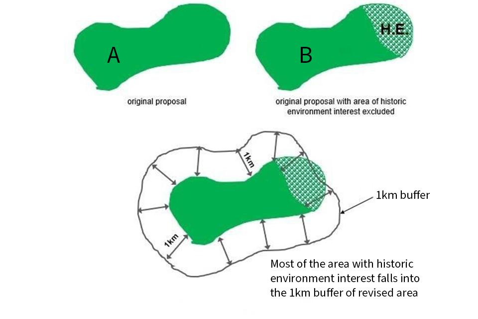
Step 2: defining a 1km buffer: area 'A' shows the original proposal. Area 'B' shows original proposal with area of historic environment interest excluded. Most of the area with historic environment interest falls into the 1km buffer of revised area
Step 3
Wader recovery areas: currently there is only one recognised wader recovery area in the geographical areas covered by this guidance, the Curlew Life Geltsdale & Hadrian’s Wall initiative.
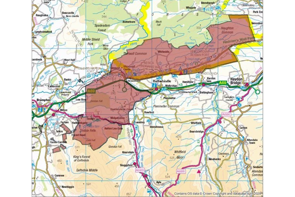
Step 3: a map showing the wader recovery area
Additional wader recovery areas will be identified over time, including as part of the development of nature recovery strategies, with the intention of making them available as a wader recovery mapped layer on MAGIC.
Step 4
Applicants are encouraged to approach RSPB (although they are not statutory consultees) for advice in relation to Important Bird Areas (IBAs), these can be found on MAGIC.
Step 5: predator shadows
When assessing woodland creation proposals, we and NE will consider the potential extension of predator shadow onto open land and/or the increase in predator pressure, in conjunction with the suitability of the surrounding landscape for waders. This will include consideration of the following factors:
-
The degree of sensitivity/suitability of the landscape onto which this shadow falls, for example, the likelihood that the characteristics of the landscape and habitat within it are suitable for breeding waders. This may include gently sloping, enclosed, semi-improved grassland as well as areas of semi-natural habitat.
-
Where breeding waders are known to be present in the landscape, even where there is significant woodland cover, for example, due to a long and sustained history of intensive predator control at landscape scale as a result of grouse moor management or other land management practices that depress predator activity.
We and NE have created a new woodland predation shadow for waders mapping layer which can be accessed on our map browser. This mapping layer provides a representation of how new woodland creation could encroach into open land. This layer uses the latest version of the NFI and assigns a 500m buffer from existing NFI woodland.
Zone 1
Land that is already covered by existing predator shadow (from one or more NFI woodlands) and is 500m or more away from open land not covered by existing predator shadow. New woodland creation in zone 1 is unlikely to significantly encroach onto open land.
Zone 2
Land within existing predator shadow that lies within 500m of open land and existing NFI woodland. New woodland creation in zone 2 will result in encroachment of predator shadow onto open land.
Whilst woodland creation in zone 1 may not result in a significant extension of predator shadow, it will result in an increase in predator pressure. Where breeding waders are present an increase in predator pressure is likely to have a significant adverse impact, therefore woodland creation is unlikely to be appropriate. Woodland creation in zone 2 that results in minimal encroachment on to open land may be appropriate in certain situations e.g. in cloughs.
Assessing woodland predation shadow for waders mapping layer
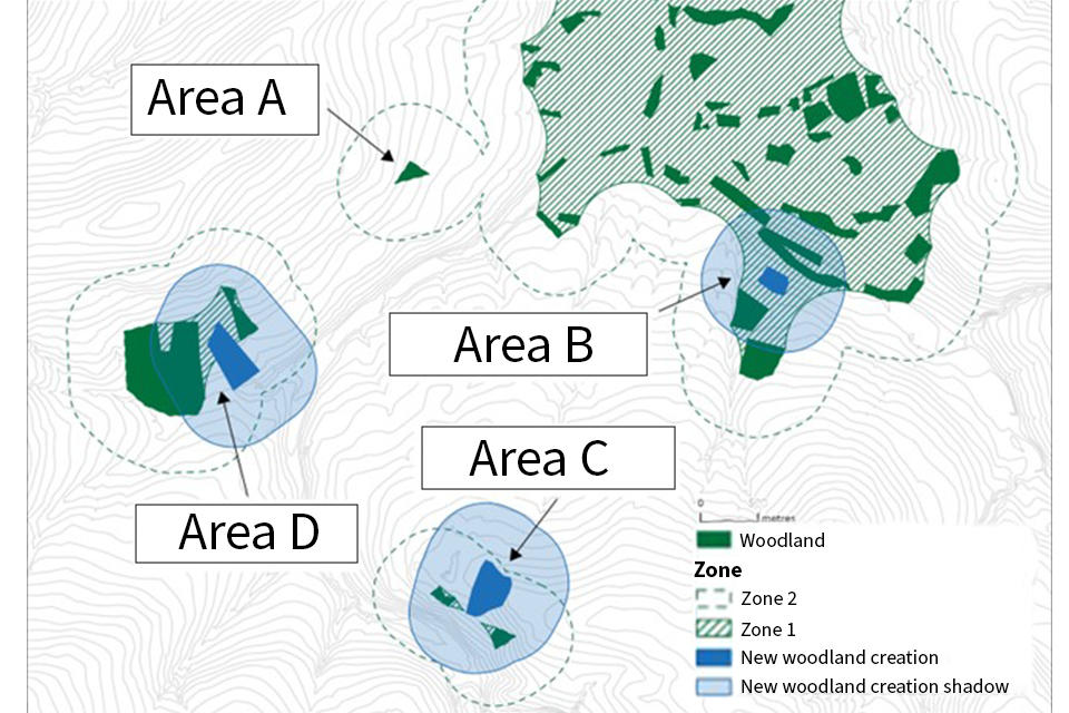
Step 5: predation shadow image
Step 5 predation shadow image shows:
Area A: some existing woodland is sparse or isolated enough to only produce a zone 2 predation shadow.
Area B: new woodland creation in zone 1 is at least 500m away from open land and will not result in additional encroachment onto open land.
Area C: New woodland creation in zone 2 is within 500m of open land and will result in additional shadow encroachment onto open land.
Area D: new woodland creation that crosses zone 1 into zone 2 will still result in additional shadow encroachment onto open land.
Step 6
Viable existing records will be those that come from credible sources such as local records centres, the RSPB, BTO or local bird clubs, which have used a suitable methodology and are at suitable resolution.
Step 7
Areas of land that have consistent slope more than 20 degrees and which do not have intervening areas of lower degree slope can be excluded from the need for survey as waders are unlikely to nest on ground with this degree of slope.
A slope of 20 degrees equates to increase in altitude of 180m over a 500m distance, a 36% slope or an approximately 1 in 3 gradient.
Appendix 3: determining the suitability of sites for woodland creation where we have breeding wader information
Step 1
Is the proposed woodland creation site within 1km of a SSSI with breeding waders as a notified feature or 2km of an SPA with breeding waders as a qualifying feature or within 1km of an existing wader recovery area e.g. Curlew Life?
Yes: consult with NE over design proposals at the earliest possible opportunity (step 2).
No: move to step 3.
Step 3
Are breeding waders present on the proposed site or its 1km buffer?
Yes: move to step 4.
No: go!
Step 4
Within the area covered by the site and the surveyed buffer, is there one or more breeding pair per km2 of curlew or redshank or 2 or more pairs of lapwings per km2?
Yes: move to step 5.
No: go!
Step 5
Is there woodland cover within 500m of the proposal?
Yes: move to step 6.
No: move to step 7.
Step 6
Will the proposal extend the predator shadow onto open land outside zone 1, or increase predation pressure onto land within zones 1 or 2 where breeding waders are present in suitable habitat?
Yes: move to step 7.
No: go!
Step 7
Discuss with applicant: can the proposal be altered to prevent this?
Yes: go!
No: move to step 8.
Step 8
Will the proposal deliver habitats of high wildlife value?
Yes: move to step 9.
No: stop!
Step 9
Do the biodiversity benefits outweigh the impact on breeding waders?
Yes: go!
No: stop!
See notes below for interpretation and explanation of key decision point boxes.
Appendix 3 notes: determining the suitability of sites for woodland creation where we have breeding wader information
Step 1
This allows for the fact that where breeding waders are features of protected sites, the birds that nest within the sites can be dependent e.g. for foraging/chick- rearing on functionally linked land that is outside of the protected site’s boundaries and can therefore come within the scope of the CRoW Act and Habitats Regulations.
The notified features of SSSIs and SPAs can be found on Natural England’s site search.
The importance of areas determined to be critical to meeting wader recovery ambitions are also recognised here. Currently there is only one recognised wader recovery area in the geographical areas covered by this guidance, the Curlew Life Geltsdale & Hadrian’s Wall initiative. Additional Wader Recovery Areas will be identified over time, including as part of the development of nature recovery strategies, with the intention of making them available as a wader recovery mapped layer on MAGIC.
Step 2
Contact Natural England at woodlandcreation@naturalengland.org.uk for a consultation proforma if you do not already have one.
Step 3 and 4
This may be based on results of commissioned survey results or viable historical data dating from 2016 or later. Viable historical records will be those that come from credible sources such as local records centres, the RSPB, BTO or local bird clubs, which have used a suitable methodology and are at suitable resolution.
Where there are no records or where historical records do not result in a yes answer to step 3 and to step 4 a new survey should be commissioned. This is on the basis that absence of records is not evidence of absence of waders.
When calculating the breeding wader density per km2 all land that was excluded from the survey due to existing woodland cover, degree of slope, small field size or lack of predation shadow extension should be excluded from the calculation (see Annex 9 of the ecological assessment and survey guidance).
The density for curlew, redshank or lapwing will be calculated separately. If any are above the density threshold then move to step 5.
How to create 1km buffers:
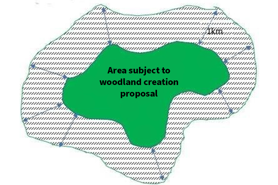
How to create 1km buffers: the diagram shows the woodland creation proposal area surrounded by a 1km buffer
Box 6
See notes for appendix 2, Box 5.
Box 7
Defining habitats of high wildlife value:
The proposal should be based on exclusive use/colonisation of native tree species and be expected to be capable of meeting the definition of one of the following S41 woodland priority habitats over time: Wood-Pasture & Parkland, Upland Oakwood, Upland Mixed Ashwoods, Upland Birchwoods, Wet Woodland and/or native scrub habitats.
It may include potential for enhancement of wildlife value of the following habitats within the woodland design, for example: Upland Calcareous Grassland; Upland Hay Meadows; Coastal and Floodplain Grazing Marsh; Upland Heathland; Upland Flushes; Fens and Swamps; Purple Moor Grass and Rush Pastures; Blanket Bog; Mountain Heaths and Willow Scrub; Inland Rock Outcrop and Scree Habitats; Calaminarian Grasslands; Limestone Pavement.
Box 8
To assess whether the biodiversity benefits outweigh the impact on breeding waders consider the following:
- proximity of the site and its 1km buffer to any wader recovery areas
- the density of breeding wader territories within the site and its 1km buffer
- the number of waders within the site and its 1km buffer
- the range of wader species within the site and its 1km buffer
- successful delivery of agri-environment wader-specific options within the site and its 1km buffer
Against the following:
- occurrence of woodland as notified features of any SSSIs/Special Areas of Conservation (SACs) involved
- contribution to expansion of priority woodland habitats in support of their Favourable Conservation Status
- tree establishment through natural colonisation or low-density planting below 600/ha will have greater wildlife benefits
- good evidence of significant benefits to non-woodland priority habitats from removal or relaxation of grazing pressures
- good evidence of significant benefits to other priority species
- provision of connectivity between existing areas of native tree cover
- tree establishment in areas that will not be in sightlines to areas used by waders, e.g. in cloughs and valleys, will have less impact
There is an expectation that as Local Nature Recovery Strategies are developed, they can be expected to contribute to the assessment.
-
Moorland habitats and adjacent unimproved or semi-improved grassland pastures and meadows ↩
-
Northumberland, Durham, Cumbria, Yorkshire, Lancashire, North York Moors and the Peak District ↩
-
Heywood, J.J.N., Massimino, D., Balmer, D.E., Kelly, L., Noble, D.G., Pearce-Higgins, J.W., Woodcock, P., Wotton, S., Gillings, S. & Harris, S.J. 2023. The Breeding Bird Survey 2022. BTO Research Report 756. British Trust for Ornithology, Thetford. ( BBS 2022) ↩
-
You can check if a designated site is notified for individual breeding wader species and/or where waders are included as scoring features in a breeding bird assemblage by consulting Natural England’s Designated Sites View webpage Site Search (naturalengland.org.uk) ↩