HM Land Registry: Boundaries and boundary disputes
This guide explains property boundaries in England and Wales, what HM Land Registry can tell you, and what to do if there is a dispute.
HM Land Registry title plans are based on Ordnance Survey (OS) mapping and usually show general boundaries, not exact legal boundaries. They help identify registered land, but the red edging on the title plan is not a precise measurement. For questions about fences, walls or hedges, check the register, deeds and documents received from your solicitor.
What should you check first if you have a boundary question?
- check your title register and title plan
- look for deeds marked “copy filed”
- check any documents from your solicitor
- speak to your neighbour before changing or moving a boundary feature
- get advice from a legal professional or chartered surveyor if you need to know the exact legal boundary
What is the difference between a legal boundary and a physical boundary?
A legal boundary is the invisible line between two pieces of land. It does not always follow a fence, wall, hedge or other feature that you can see.
A physical boundary is something visible, such as a fence, wall, hedge, ditch or tree line. It may follow the legal boundary, but it may also sit to one side of it or change over time.
What does an HM Land Registry title plan show?
General boundaries
The red edging on a title plan shows the registered land. In almost all cases, it shows the general boundary only.
A general boundary shows the approximate position of the boundary. It does not show the exact legal line between two properties.
When we prepare a title plan, we show the boundary as clearly as we can. The red edging often follows features shown on the Ordnance Survey (OS) map, such as walls, hedges and fences. A legal boundary may follow one of these features, but it cannot be assumed that it does. If it does follow a feature, the title plan does not show exactly where. For example, the boundary might run through the middle of a hedge or along one side of it.
Also, title plans are based on OS maps and these have limits because of their scale and accuracy, particularly as physical boundaries change over time. Often the title deeds and other information we receive do not show the precise position of the legal boundaries.
This means you should not rely on measurements taken from a title plan to try to work out the exact position of a legal boundary on the ground.
For more information about what a title plan shows, see How to read a title plan.
Other information that may help show the boundary
You may be able to work out the legal boundary more precisely by looking at the title deeds used when the property was first registered. If you do not have these title deeds, you may be able to obtain copies from HM Land Registry using form OC2.
Even where the title deeds are available, it may not be possible to work out the precise position of the legal boundary from them. For example, the plans may be unclear, or the original position of the legal boundary may have changed over time.
If you are the tenant of a leasehold property such as a first-floor flat, you may find the red edging on your title plan shows the outline of the building rather than the flat itself. This is because we produce our plans on small-scale OS maps, which cannot show every detail. It is very important to read the register and title plan together with the lease to understand the agreement made between the original parties.
Who owns or maintains a boundary fence, wall or hedge?
There is no rule that the fence, wall or hedge on the left or right of a property belongs to that property owner. Which side of a fence the posts and rails are on is not a reliable guide either.
The title register, deeds or documents from your solicitor may include information about ownership or maintenance responsibility, but many do not. If the register refers to a deed as “copy filed”, you can apply for a copy using form OC2.
A deed may include a covenant, or legally binding promise, to maintain a wall, fence or other boundary feature. This can help show who is responsible for maintenance, but it does not always mean that person owns the feature.
It is also possible that a boundary feature has been replaced since the deed was created and different responsibilities for maintenance agreed at the time.
Some deed plans show “T” marks. These often indicate who is responsible for maintaining a boundary feature, but they are not always conclusive. Check the wording in the deed too.
Example: If a plan shows a “T” mark on your side of a boundary line, it may mean you are responsible for maintaining that fence, wall or hedge. If there are “T” marks on both sides (sometimes called “H” marks) this may mean both neighbours share responsibility. Always check the wording in the deed or register because the marks alone may not give the full answer.
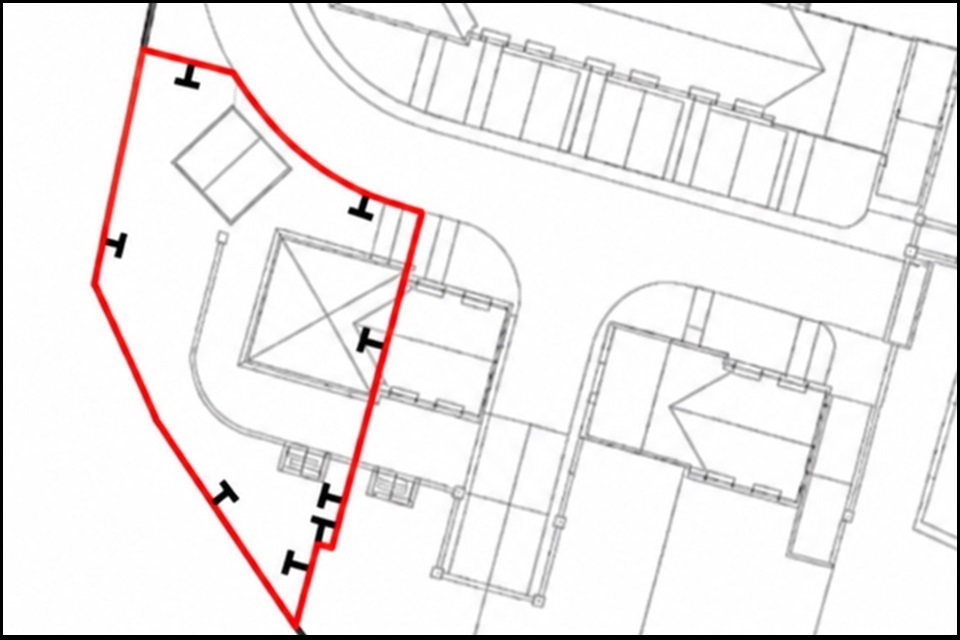
The ‘T’ marks on this plan show who is responsible for each boundary. If the ‘T’ sits inside your property boundary, you generally own and must maintain that fence or wall. If two ‘T’ marks meet back to back on a boundary line, it forms an ‘H’ shape. This indicates a party wall or shared boundary, meaning both neighbours share upkeep costs.
Boundary features can change over time. Before changing a fence, wall, hedge or other feature, speak to your neighbour first.
If you think your title plan needs changing
The fact that the title plan only shows the general boundaries of a property does not mean that the red edging cannot be moved.
In some cases, we may be able to move the red edging so it shows the general boundary in a more accurate position. Note, however, that the red edging will still only show a general boundary, not the exact legal boundary.
If you think the red edging on your title plan is in the wrong place, or that the title plan is wrong in another way, contact our customer support centre and we will investigate the matter.
You need to tell us clearly what you think is wrong and provide appropriate evidence in support.
If we do not agree that something is wrong, we will tell you why.
If we agree that there is a mistake, we will explain what happened. We will then either try to put it right or indicate whether you can apply to change the title plan.
Mistakes may not be made originally by HM Land Registry, but we are responsible for making sure that our title plans do not contain any errors.
You can write to us at:
HM Land Registry
Citizen Centre
PO Box 7806
Bilston
WV1 9QR
Can HM Land Registry resolve a boundary dispute?
No. HM Land Registry cannot decide, mediate or resolve boundary disputes between neighbours. A title plan with general boundaries cannot be used to settle a disagreement about the exact legal boundary.
If there is a disagreement, try to agree a practical solution before taking formal action. Mediation may help you avoid court or tribunal proceedings, which can be very costly.
The Royal Institution of Chartered Surveyors (RICS) has public guidance on boundary disputes in England and Wales and may be able to help through its Boundary disputes mediation service. It also has a list of firms who provide a free 30-minute initial consultation at Find a Surveyor.
Making a boundary agreement
Registration with general boundaries is normally all that is required but, if you want something more precise, you might consider a boundary agreement.
A boundary agreement can be more precise about the position of a boundary than a title plan with general boundaries. For example, owners may agree that the boundary between their properties is the middle of a hedge.
It can also say who is responsible for maintaining a boundary feature, such as a hedge, wall or fence. For example, you might agree that each owner will keep their side of a hedge below a certain height.
A boundary agreement does not have to include a detailed plan. You and your neighbour can decide how much detail to include. In fact, the parties could agree not to refer to any plan in their agreement, relying entirely on a written description.
If at least one of the pieces of land involved is registered, an application can be made to HM Land Registry to record a boundary agreement on the register.
Once a boundary agreement has been made, it applies not only to the owners at the time but to future owners as well.
For more information see: Make a boundary agreement with your neighbour on GOV.UK.
What if I cannot make an agreement?
If a boundary agreement is not possible, you may be able to apply to HM Land Registry for the precise line of the boundary to be determined.
HM Land Registry does not decide where the legal boundary is if neighbours disagree. You would need to make out an arguable case for the exact line of the boundary being where you claim it to be and to show us the exact line on a plan. If the application is accepted, we add information to the register to show that the legal boundary has been determined and where the exact line is.
In practice, the plan which is used in the application for a determined boundary will almost always need to be produced by a chartered land surveyor.
Only a very small fraction (less than 1%) of registers have determined boundaries. This is usually because applying can be expensive.
There is also a real risk that applying for a determined boundary without the consent of all the neighbours involved will lead to a costly dispute before the First-tier Tribunal.
For most properties, general boundaries are sufficient. If not, a boundary agreement is often simpler and is likely to be less expensive than applying for a determined boundary.
What if the property borders a public highway?
If your property borders a public highway, the title plan will not show the exact boundary between private land and highway land. Land that looks private may still form part of the highway, so check before making changes near a road, pavement, verge or access route. For more information, see our blog What owning a land or property near a public highway can mean on GOV.UK.
What if I am carrying out work near a boundary or party wall?
The Party Wall etc. Act 1996 may apply if you plan to carry out work on a shared wall or close to a boundary. HM Land Registry cannot advise on the Act. You may need advice from a solicitor, licensed conveyancer or surveyor.
More information about boundaries
The law relating to boundaries is complicated, so if you need to establish the legal boundaries of your property, or if there is a disagreement with a neighbour about them, you may wish to consult a legal adviser.
Please note that HM Land Registry cannot give legal advice.
There is more information about boundaries in HM Land Registry Practice Guides. In particular, Practice Guide 40, Supplement 4 deals with boundary agreements and determined boundaries. Please note that Practice Guides are written for professional conveyancers, such as solicitors.
Useful links and further guidance
- Video: How to find information about your property boundaries
- How to read a title plan
- How to read a title register
- Get a copy of the deeds
- Practice Guide 40, Supplement 3: Boundaries
- Practice Guide 40, Supplement 4: Boundary agreements and determined boundaries
- Resolving neighbour disputes
- RICS guidance and mediation for boundary disputes