Witham abstraction licensing strategy
Published 17 December 2020
Applies to England

© Crown copyright 2020
This publication is licensed under the terms of the Open Government Licence v3.0 except where otherwise stated. To view this licence, visit nationalarchives.gov.uk/doc/open-government-licence/version/3 or write to the Information Policy Team, The National Archives, Kew, London TW9 4DU, or email: psi@nationalarchives.gov.uk.
Where we have identified any third party copyright information you will need to obtain permission from the copyright holders concerned.
This publication is available at https://www.gov.uk/government/publications/witham-abstraction-licensing-strategy/witham-abstraction-licensing-strategy
1. About the licensing strategy
1.1 Overview
This strategy sets out how we manage new and existing abstraction and impoundment within the Witham catchment in the Anglian river basin district.
It ensures that we:
- meet River Basin Management Plan (RBMP) objectives for water resources activities
- avoid deterioration within this catchment
We apply this approach to the water body in which the abstraction is located.
It also applies to:
- all downstream surface water bodies that may be affected by any reduction in abstraction related flow
- adjacent groundwater bodies affected by any reduction in groundwater level
The strategy also sets out local approaches to the sustainable management of water resources. This is in collaboration with partners.
Managing water abstraction describes the technical explanation, legal and policy requirements behind the Abstraction Licensing Strategy (ALS).
The abstraction pages advise on:
- who needs an abstraction or impoundment licence
- how to apply
1.2 How is the licensing strategy set out?
This ALS provides an overview of how water is sustainably managed in the Witham catchment to:
- provide water for abstraction
- protect the environment
A summary of what each section covers:
Catchment background - sets out additional information on the background and pressures.
Water resource availability - explains how much water is available for abstraction in the catchment.
How we manage water resource availability - explains the local licensing approach for the catchment which is summarised in Table 2. This includes the potential water available for licensing and the restrictions that would be required.
Managing the catchment together - details the actions we are taking where abstraction is currently unsustainable in the catchment. Approaches to ensure sustainable water management in the future are outlined, including information on licence trading.
Related links - are listed for further information on water resource management.
Glossary - of useful terms.
Contact details - on how to get in touch.
Note: whilst our assessment tools are continuously updated, we aim to update this document on a 3-year basis. Therefore some details within this document, for example Hands off Flow (HoF) values, may be outdated. Use this document as a guide to water availability. For up to date and detailed advice see the section ‘contact details’.
1.3 Collaborative and sustainable water management
Our long-term goal is to develop a stronger catchment focus for water resources management. We are working with abstractors and catchment groups to:
- develop local solutions to existing pressures
- prepare for the future
Catchment groups may include a variety of different partnership groups such as:
- abstractor groups
- local catchment partnerships
- priority catchment groups
- environmental groups
Since the autumn of 2018, we have been collaborating with local partners. In several priority catchments across England we have explored:
- modern and innovative ways of improving access to water
- achieving sustainable abstraction
The South Forty Foot catchment was selected as a priority catchment in the Defra water abstraction plan.
We assessed water resource availability using our standard approach. We have then worked with partners to:
- identify local opportunities to modernise abstraction management
- share resources sustainably both now and in the future
Background information on the priority catchment project is available in the catchment background section Further details and links on approaches trialled in this catchment are provided in the managing the catchment together section.
This strategy provides a tool to make informed decisions on the choices abstractors make about their use of water. We want this strategy to help abstractors:
- plan their water use and become more resilient in the face of climate change
- explore the opportunities offered by the priority catchments
2. Catchment background
2.1 Catchment overview
The catchment area extends across a large part of central and southern Lincolnshire.
Landscape and land use
The catchment covers an area of approximately 3,261km 2. The majority of the catchment is rural with good agricultural land.
- population: 488,000 (estimated from ONS 2019 mid-year local authority estimates)
- 2028 farms covering 283,079 hectares of farm land (Defra farm statistics)
Land use statistics based upon LCM2019 © NERC (UKCEH) 2020:
| Land Use Type | Proportion of catchment (%) |
|---|---|
| Permanent grassland | 12.1% |
| Arable | 74.5% |
| Urban | 7.3% |
| Forested | 4.6% |
| Other | 1.5% |
The photograph shows the River Witham looking upstream from Five Mile Bridge near the city of Lincoln.

Water resources
The Lincolnshire Limestone is the main aquifer within the Witham ALS. It helps meet demands for public water supply and, to a lesser extent, agriculture. The Spilsby Sandstone aquifer also supports public water supplies. Only a small proportion of this aquifer falls within the catchment. But this outcrop is important because it provides the main recharge opportunity for the aquifer. There are also some locally important secondary aquifers within the catchment, such as the Bain Sands and Gravels.
The major river in the catchment is the River Witham which:
- rises south of Grantham
- passes through Lincoln
- discharges into The Wash at Boston
As with most rivers in the catchment, the Witham becomes an embanked channel in its lower reaches where it crosses the fens. A tidal sluice at Boston maintains levels in the embanked channel. The River Witham also benefits from the Trent-Witham-Ancholme Scheme (TWAS). This is a key infrastructure link for:
- managing water resources
- maintaining summer water levels
- meeting agricultural, public water supply, industrial and environmental needs
Other significant rivers in the catchment (all tributaries of the Witham) are:
- River Brant
- River Bain
- River Slea
- Barlings Eau
There are extensive drainage networks, for example, in the East and West Fens north of Boston and the South Forty Foot catchment.
Internal Drainage Boards are largely responsible for:
- the artificial dykes and drains which drain the fens
- the subsequent pumping of water into the main river or directly into the sea
The largest surface water abstraction licence in this ALS area is at Short Ferry (part of the TWAS). This enables the transfer of water into the neighbouring Ancholme catchment. This meets demand for public water supply and industrial uses. Other significant abstraction licences are for public water supply. These are primarily from the confined Lincolnshire Limestone aquifer. There are also numerous licences for spray irrigation reflecting the importance of agriculture in this ALS area.
50 million m3
of water abstracted/year (based on 2013-18 average)
- 567 licensed abstractions
- 90 licences with Hands off Flow (HoF) restrictions at 20 gauging stations
- 15% of the catchment underlain by principal aquifer
Proportion of different sectors based on licensed abstraction quantity:
| Abstraction licence sector | Proportion of total licensed quantity (%) |
|---|---|
| Public water supply and other potable uses | 48.7% |
| Agriculture | 17.2% |
| Industry | 9.1% |
| Amenity/environmental | 25.1% |
Climate change
Climate change will impact on the quantity and seasonal availability of water resources within the catchment.
The projected climate change impacts on rainfall and river flow for the Anglian region by the 2050s are for:
- rainfall to decrease by 39% in the summer but increase by 35% in the winter
- low flows to be 81% lower but peak river flows to be 35% higher
Climate change projections are estimated using data from UKCP09, consistent with a 4ºC rise by 2100. The Environment Agency Climate impacts tool provides further details on the assumptions used.
Environment and sustainability
The area has some sites of high conservation importance. It also has the southern tip of the Lincolnshire Wolds. This is an Area of Outstanding Natural Beauty (AONB) which has important conservation value.
The River Witham flows into The Wash embayment. This is the largest estuarine system in the UK. It is designated as a Site of Special Scientific Interest (SSSI). The SSSI also forms part of :
- The Wash and North Norfolk Coast marine Special Area of Conservation (SAC)
- The Wash Special Protection Area (SPA)
- The Wash Ramsar (designated to be of international importance under the Ramsar Convention)
The ALS area also contains many natural features designated as SSSI, several of which are water dependent. There are also Local Nature Reserves (LNRs).
The Water Framework Directive (WFD) requires that measures are taken to protect and improve the hydrological regime of water bodies.
51 designated protected areas (SACs, SPAs, SSSIs, LNRs and Ramsar )
Licence reductions:
- Restoring Sustainable Abstraction (RSA) programme: 3,842,677 m3/year
- unused and underused licence project: 4,277,138 m3/year
Water Framework Directive:
- 79 water bodies
- 5% water bodies at good status or higher
- 24% water bodies where flow pressure does not support good status
2.2 The priority catchment initiative and partnership working
The South Forty Foot catchment was selected as a priority catchment in the water abstraction plan.
Since the autumn of 2018, we have been working with water users and other partners exploring modern ways of managing water. We are working together across sectors including:
- public water supply
- agriculture
- environment
- flood risk management
- navigation
This delivers multi-functional outcomes which are good for
- the environment
- people and business
The South Forty Foot catchment was selected as a priority catchment for a number of reasons including:
- the South Lincolnshire Water Partnership (SLWP) were keen to be involved in the priority catchment initiative
- the possibility of a significant water company strategic option being developed in the area
- an increasing interest in water abstraction in the catchment
- a number of engaged water users who were keen to explore novel approaches to water management
The South Lincolnshire Water Partnership (SLWP) is chaired and hosted by The Black Sluice Internal Drainage Board. The majority of the Black Sluice Internal Drainage District sits within the South Forty Foot Catchment. The SLWP includes representatives from a wide variety of sectors.
Further information regarding the activities of the partnership are available on the Water Resources East website.
If you would like to get involved in the SLWP contact the Black Sluice Internal Drainage Board. We are working with the SLWP to embed priority catchment initiatives.
In the wider Witham catchment there are other partnerships. The Witham Catchment Partnership, hosted by The Lincolnshire Rivers Trust is very active. It brings together stakeholders from a range of backgrounds to address issues in the catchment. For more information and details of how to get involved visit the Lincolnshire Rivers Trust website.
In addition there are a number of active water abstractor groups in the Witham catchment including:
| Group | Area | Host |
|---|---|---|
| Fenland Agricultral Water Group | South Lincolnshire | G&D Matthews Ltd |
| Lincoln Heath Water Abstractor Group | Between Lincoln and Sleaford | Blankney Estates |
| Lincoln Water Transfer Ltd | West of Lincoln | Lincoln Water Transfer Ltd |
| Water Transfer Limited | Witham IV area, north of Boston | Witham IV IDB & NFU |
The UK Irrigation Association have produced a number of helpful booklets. These include one covering Water Abstractor Groups ‘Working together to protect water rights’. See the section Related links for further details.
3. Water resource availability in the Witham catchment
3.1 Surface water availability
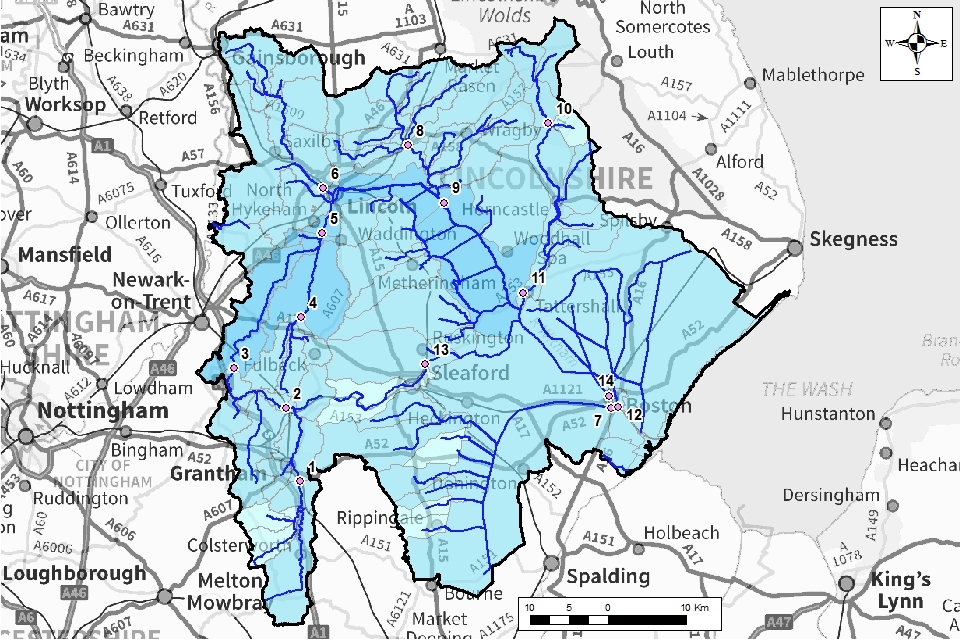
The method for calculating the water resource availability is explained in Managing water abstraction. Water availability is calculated at selected Assessment points (APs). The maps show the water availability calculated at the AP, local water availability may differ. There are 14 APs in the Witham ALS:
- AP1: covers the Upper Witham from its source at South Witham (includes the tributary of the Cringle Brook) - this section of the River Witham also falls within the Upper Witham Internal Drainage Board (IDB)
- AP2: covers the River Witham as it flows through the town of Grantham - this section of the River Witham also falls within the Upper Witham IDB
- AP3: covers the River Witham as it flows downstream towards Claypole - this section of the River Witham also falls within the Upper Witham IDB
- AP4: covers the River Brant and tributaries, including the Sand Beck - this section of the River Witham also falls within the Upper Witham IDB
- AP5: covers the River Witham at North Hykeham, downstream of the confluence with the River Brant - this section of the River Witham also falls within the Upper Witham IDB
- AP6: covers the Fossdyke Navigation and River Till catchment - the Fossdyke Navigation is an important part of the TWAS, transferring water from the River Trent to the River Witham
- AP7: covers the South Forty Foot catchment and falls within the Black Sluice IDB
- AP8: covers the Barlings Eau upstream of Langworth - tributaries of the Barlings Eau include Dunholme Beck and Scothern Beck
- AP9: covers the River Witham downstream of Lincoln to Bardney - the River Witham is embanked in its lower reaches as it crosses the fens; the area to the left of the river as it moves downstream is covered by Witham Third IDB and to the right by Witham First IDB
- AP10: covers the upper River Bain as it flows downstream through Burgh on Bain and Donington on Bain to Goulceby
- AP11: covers the River Bain as it flows further downstream through Horncastle and Coningsby (includes the tributaries of Haltham Beck and Scrivelsby Beck) - this section of the River Bain falls within the Witham Third IDB
- AP12: covers the Maud Foster catchment - the extensive drainage network to the left and right falls within Witham Fourth IDB
- AP13: covers the catchment of the River Slea to Leasingham
- AP14: covers where the River Witham discharges into The Wash at Grand Sluice, Boston
Water resource availability colours and implications for licensing
We use colours to represent different surface water availability at a range of flows:
Water available for licensing
Green
There is more water than required to meet the needs of the environment. New licences can be considered depending on local and downstream impacts.
Restricted water available for licensing
Yellow
Full Licensed flows fall below the Environmental Flow Indicators (EFI).
If all licensed water is abstracted there will not be enough water left for the needs of the environment. No new consumptive licences would be granted. It is likely we’ll be taking action to reduce full licensed risks. Water may be available if you can ‘buy’ (known as licence trading) the entitlement to abstract water from an existing licence holder.
Water not available for licensing
Red
Recent actual flows are below the EFI.
This scenario highlights water bodies where flows are below the indicative flow requirement to help support a healthy ecology in our rivers. We call this ‘Good Ecological Status’ (GES) or ‘Good Ecological Potential’ (GEP) where a water body is heavily modified for reasons other than water resources.
Note: we are currently taking action in water bodies that are not supporting GES or GEP. We will not grant further licences. Water may be available if you can buy (known as licence trading) the amount equivalent to recently abstracted from an existing licence holder.
Heavily Modified Water Bodies (HMWBs) and/or discharge rich water bodies
Grey
These water bodies have a modified flow that is influenced by reservoir compensation releases or they have flows that are augmented. These are often known as ‘regulated rivers’. They may be managed through an operating agreement, often held by a water company. The availability of water is dependent on these operating agreements. More detail if applicable can be found in the section ‘surface water’.
There may be water available for abstraction in discharge rich catchments, you need to contact us to find out more.
The water resource availability is calculated and the colour assigned at 4 different flows:
- Q30 - the flow of a river which is exceeded on average for 30% of the time, therefore you would expect the river flow to be lower than Q30 on 256 days in an average year, i.e. a higher flow
- Q50 - the flow of a river which is exceeded on average 50% of the time, therefore you would expect the river flow to be lower than Q50 on 183 days in an average year
- Q70 - the flow of a river which is exceeded on average for 70% of the time, therefore you would expect the river flow to be lower than Q70 on 110 days in an average year
- Q95 - the flow of a river which is exceeded on average for 95% of the time, therefore you would expect the river flow to be lower than Q95 on 18 days in an average year, i.e. a low flow
Water availability maps
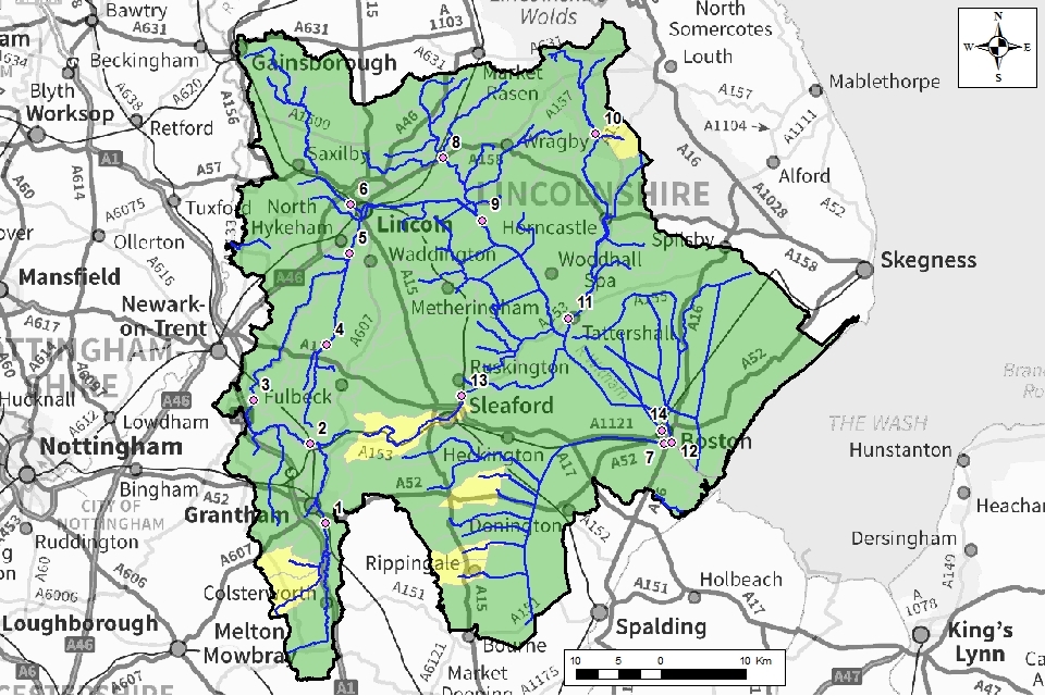
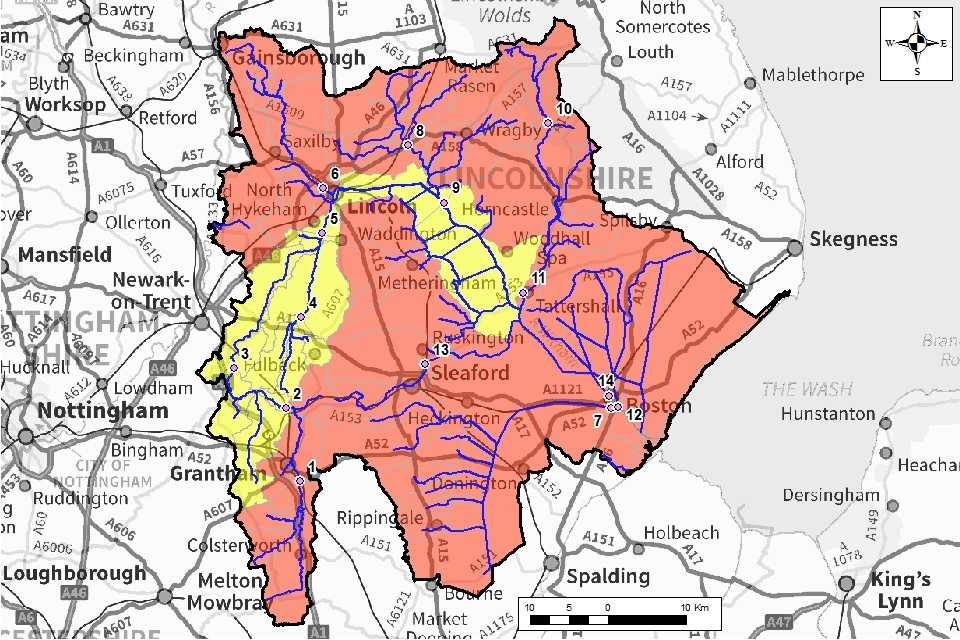
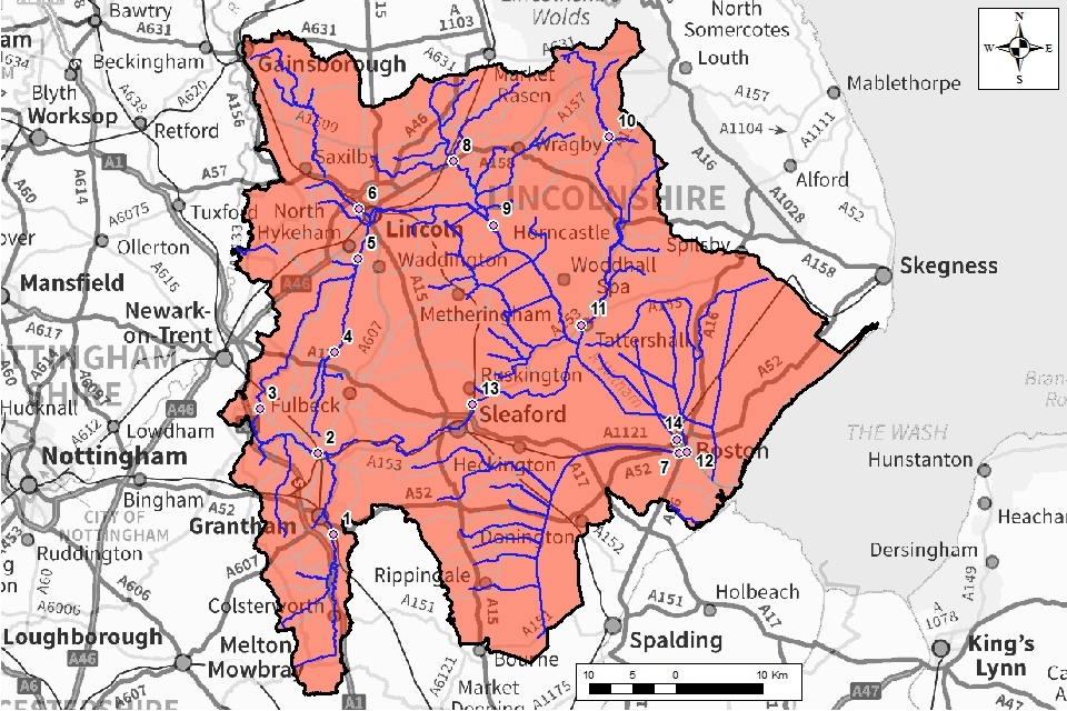
The water availability colours for the Witham catchment are presented in Maps 1-4.
Table 1: Summary of Maps 1 to 4 - water availability at each assessment point by flow category
| Q30 | Q50 | Q70 | Q95 | |
|---|---|---|---|---|
| AP1 | Available | Restricted | Not available | Not available |
| AP2 | Available | Restricted | Not available | Not available |
| AP3 | Available | Restricted | Restricted | Not available |
| AP4 | Available | Restricted | Restricted | Not available |
| AP5 | Available | Available | Restricted | Not available |
| AP6 | Available | Restricted | Not available | Not available |
| AP7 | Available | Restricted | Not available | Not available |
| AP8 | Available | Not available | Not available | Not available |
| AP9 | Available | Available | Restricted | Not available |
| AP10 | Available | Not available | Not available | Not available |
| AP11 | Available | Restricted | Not available | Not available |
| AP12 | Available | Restricted | Not available | Not available |
| AP13 | Restricted | Not available | Not available | Not available |
| AP14 | Available | Available | Restricted | Not available |
Map 1: Water resource availability colours at Q30 for Witham ALS
© Environment Agency copyright
Map 2: Water resource availability colours at Q50 for Witham ALS

© Environment Agency copyright
Map 3: Water resource availability colours at Q70 for Witham ALS
© Environment Agency copyright
Map 4: Water resource availability colours at Q95 for Witham ALS
© Environment Agency copyright
Abstractions from the River Witham are supported by the Environment Agency’s Trent-Witham-Ancholme scheme (TWAS). If you apply for a licence which is linked to the TWAS you will benefit from the improved resource reliability provided by the support scheme. See section 4.1 ‘Surface Water’ for more information.
3.2 Groundwater resource availability
In certain areas, resource concerns over groundwater mean that the standard water resource availability colours have been overridden.
Groundwater resource availability colours and implications for licensing
We use colours to represent different groundwater availability at a range of flows:
Water available for licensing
Green
Groundwater unit balance shows groundwater available for licensing. New licences can be considered depending on impacts on other abstractors and on surface water.
Restricted water available for licensing
Yellow
Groundwater balance shows more water is licensed than the amount available. But the actual situation is sustainable because either:
- recent actual abstractions are lower than the amount available
- management options are in place to deal with known local impacts
In restricted groundwater units no new consumptive licences will be granted. We may also investigate the possibilities for reducing fully licensed risks. Water may be available if you can ‘buy’ (known as licence trading) the entitlement to abstract water from an existing licence holder.
In other units there may be restrictions in some areas e.g. in relation to saline intrusion.
Water not available for licensing
Red
Groundwater unit balance shows more water has been abstracted based on recent amounts than the amount available. We will not grant further licences. Non-consumptive licences will be considered on a case-by-case basis.
3.3 Groundwater availability maps
Map 5: Groundwater availability colours for the Witham ALS area
The groundwater availability map shows in this catchment that there is no water available for new consumptive abstraction in:
- the Lincolnshire Limestone.
- the Lincolnshire Chalk and Spilsby Sandstone
There may be water available for consumptive abstraction in the Bain Sands and Gravels.
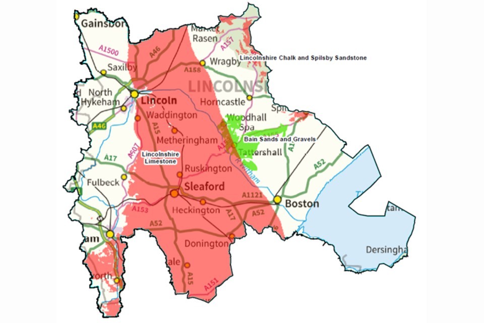
BGS © NERC. © Environment Agency copyright
Surface waters are fed by groundwater where they interact with aquifers. Springs feed headwaters or contribute further downstream. Baseflow supports flow through riverbeds along the watercourse route. If groundwater abstraction lowers the water table, this could result in these spring flows or river baseflows reducing or ceasing altogether if not properly managed. Surface waters will then be affected in terms of flow volumes (see Maps 1-4) and ecology.
3.4 Resource reliability
If you want to apply for a licence, it’s worth considering the reliability of your surface water abstraction.
By assessing the quantity of water available at different flows it’s possible to see:
- when there is a surplus or deficit of water
- the associated reliability of an abstraction
This is an indication only. Actual reliability of a licence will be discussed when you apply.
Map 6 gives an indication of the resource availability for consumptive abstraction in the Witham area expressed as a percentage of time.
In this catchment consumptive abstraction is available:
- less than 30% of the time at AP13 (pale blue on Map 6)
- at least 30% of the time at APs 1, 2, 3, 4, 6, 7, 8, 10,11 and 12 (mid-blue the Map 6)
- at least 50% of the time at APs 5, 9 and 14 (dark blue on Map 6)
Map 6: Water resource reliability of the Witham ALS expressed as percentage of time available
© Environment Agency copyright
3.5 Other considerations for resource availability and reliability
We may have to add constraints to licences such as hands off flow (HoF) conditions to protect:
- the environment
- the rights of other abstractors
As a result, when we grant a licence, it doesn’t mean that we guarantee a supply of water. These conditions specify that if the flow in the river or groundwater level drops below what’s needed to protect the environment, abstraction must reduce or stop. In dry years, restrictions are likely to apply more often. This will affect the reliability of supply.
There is no guarantee that we will grant a licence, even where water is available for abstraction. This is because we have to determine each application on its own merits. Local factors may mean we’re either unable to grant a licence as applied for, or even at all.
New licences within a catchment are usually given a Common End Date (CED). This allows them to be reviewed at the same time. The next CED for this ALS is 31 March 2028 and the subsequent one is 31 March 2040.
3.6 Impoundments
Applications for impoundments will be dealt with on a case-by-case basis. More information may be found on our water management web pages.
4. How we manage water availability in the Witham ALS area
4.1 Surface water
We assess surface water flows at Assessment points (APs). These are significant points on a river, often where 2 major rivers join or at a gauging station. APs cover multiple surface water bodies.
Where groundwater abstractions impact on surface water flows, we measure the impact at the surface water AP. Surface waters feed groundwater where they interact with aquifers:
- springs feed headwaters or contribute further downstream
- baseflow supports flow through riverbeds along the watercourse route
Groundwater abstractions can lower the water table. This could reduce groundwater inputs and affect surface water flows and the ecology.
Table 2 gives an indication of:
- how much water is available for further abstraction
- the associated restrictions we may have to apply to new and varied abstraction licences from the main river
Depending on the nature of the catchment, tributaries to the main river may be subject to different restrictions and quantities. This may be assessed locally on a case-by-case basis.
Each HoF is linked to an AP and is dependent on the resource availability at that AP. In some cases additional restrictions may apply to licences where there is a more critical AP resource availability downstream. This protects the ecological requirements of the river and other water users. This is detailed in the last column of Table 2 if applicable.
All abstraction licence applications are subject to an assessment. This takes account of any local and downstream issues. It may be subject to further restrictions.
Reading from top to bottom in Table 2 are the APs in the Witham ALS area. Reading across the columns you can see the:
- potential HoF that may be applied to a licence
- the number of days water may be available under this restriction
- the approximate volume of water in Ml/d that may be available
In cases where there is water available at all flows we may apply a Minimum Residual Flow (MRF) to protect very low flows. We’ll decide this on a case-by-case basis.
Table 2: Summary of licensing approach for the assessment points of the Witham ALS
The information in this table is correct at the time of publishing but is subject to change.
| AP | Name | AP National Grid Reference | Water Resource Availability | HOF Restriction (Ml/d) | Number of days per annum abstraction may be available | Approximate volume available at restriction (Ml/d) | Is there a gauging station at this AP? | Additional restrictions |
|---|---|---|---|---|---|---|---|---|
| 1 | Saltersford | SK 92694 33503 | Restricted Water Available | 56.4 | 153 | 8.2 | Yes | Additional HoL restrictions will apply in IDB areas. |
| 2 | Marston | SK 90877 42864 | Restricted Water Available | 62.8 | 186 | 6.9 | No | Additional HoL restrictions will apply in IDB areas. |
| 3 | Claypole | SK 84219 47990 | Restricted Water Available | 72.7 | 222 | 9.1 | Yes | Additional HoL restrictions will apply in IDB areas. |
| 4 | Brant Broughton | SK 92871 54533 | Restricted Water Available | 1.7 | 222 | 0.1 | Yes | Additional HoL restrictions will apply in IDB areas. |
| 5 | Hykeham Bridge | SK 95609 65309 | Restricted Water Available | 75.7 | 222 | 12.3 | Yes | Additional HoL restrictions will apply in IDB areas. |
| 6 | Fossdyke Jetty | SK 95737 71081 | Restricted Water Available | 77.7* | 222 | 12.3 | No | Additional HoL restrictions will apply in IDB areas. |
| 7 | South Forty Foot Outfall | TF 32606 42872 | Restricted Water Available | 74.2 | 146 | 34.8 | No | Additional LDE restrictions – see section 4.5. |
| 8 | Langworth | TF 06603 76599 | Restricted Water Available | 21.4 | 222 | 12.3 | Yes | Additional HoL restrictions will apply in IDB areas. |
| 9 | Bardney | TF 11161 69235 | Restricted Water Available | 155.5* | 222 | 12.3 | No | Additional LDE restrictions – see section 4.5. |
| 10 | Goulceby | TF 24588 79444 | Restricted Water Available | 20.4 | 131 | 2.2 | Yes | Additional HoL restrictions will apply in IDB areas. |
| 11 | Tattershall | TF 21354 57691 | Restricted Water Available | 44.3 | 146 | 8.7 | No | Additional HoL restrictions will apply in IDB areas. |
| 12 | Maud Foster Outfall | TF 33572 43044 | Water Available | 3.2 | 365 | 0.6 | No | MRF Additional HoL restrictions will apply in IDB areas. |
| 13 | Leasingham | TF 08815 48522 | Restricted Water Available | 63.9 | 91 | 10.5 | Yes | |
| 14 | Grand Sluice | TF 32385 44498 | Restricted Water Available | 236* | 222 | 21.6 | No | Additional LDE restrictions – see section 4.5. |
Trent-Witham-Ancholme Scheme (TWAS)
Abstractions from the River Witham downstream of Lincoln (APs 6, 9 and 13) are supported by the TWAS. If you apply for a licence which is linked to the TWAS you will benefit from the improved resource reliability provided by the support scheme. Abstractions which benefit from the TWAS will pay a Supported Source Factor as part of the Abstraction Charge. See Schedule 1 for the extent of the Witham Supported Source.
Tributaries
On some tributaries there is only a small amount of water available for abstraction. On these rivers we may apply a MRF to protect very low flows. However, it would only take a small abstraction to change the water availability status of these tributaries. This would mean that a HoF would apply to any future licence that was considered.
Tributaries to the main river and to the sea may be subject to different restrictions and quantities. A large part of the ALS area is covered by Internal Drainage Boards (IDBs), see Map 7. We will consult the relevant IDB for any licence which is considered in an IDB area. In level managed areas additional HoL restrictions will also apply. More information on this is provided in section 4.5 level dependent environments.
Maud Foster
Our assessment for AP12 is at the downstream limit of the Maud Foster. There will be less water available in the upper catchment. Refer to section 4.5 level dependent environments for information on abstraction within the low-lying east and west fen areas. These are managed by Witham Fourth IDB.
Limestone Becks
Assessment of proposals which may impact on the Limestone Becks will be considered on a case-by-case basis.
4.2 Groundwater
Where groundwater abstractions directly impact on surface water flows the impact is measured at the surface water AP. This includes where the impact reduces baseflow. In these cases, restrictions may be applied to licences, such as Hands off Level (HoL) conditions. The HoL is a groundwater level below which an abstractor is required to reduce or stop abstraction.
Other restrictions may apply where availability is limited or to protect the environment. An example is preventing saline intrusion.
Licence restrictions on groundwater abstractions in the Witham ALS area
Lincolnshire Limestone
The Lincolnshire Limestone is the principal aquifer in the Witham ALS area. The Lincolnshire Limestone can be up to 40m thick. Groundwater movement within this aquifer is generally west to east. In the west of the area the limestone outcrops at the ground surface allowing rainfall to recharge the aquifer. The limestone becomes confined as it is overlain by younger deposits to the east. Abstraction takes place mainly from the confined region. But the aquifer becomes too deep and the quality is considered to be too poor to exploit more than a few kilometres east of the outcrop area.
The resources in the Lincolnshire Limestone are fully committed to existing users and the environment. Consequently, no new consumptive licences will be considered. New non-consumptive licences will be considered on a case-by-case basis, and will be time-limited.
Lincolnshire Chalk
To the east of the area are the beginnings of the Lincolnshire Chalk outcrop. The Lincolnshire Chalk is a form of white limestone. Within the chalk, groundwater generally flows west to east following the shallow dip of the aquifer. Only the upper part of the confined Chalk contributes to groundwater flow. The deeper fraction is less fractured and so groundwater cannot flow through. Abstraction takes place mainly from the confined region which is outside of the Witham ALS area.
The resources in Lincolnshire Chalk are fully committed to existing users and the environment. Consequently, no new consumptive licences will be granted. New non-consumptive licences will be considered on a case-by-case basis, and will be time-limited.
Spilsby Sandstone
In the east of the area there are also outcrops of the Spilsby Sandstone. The Spilsby Sandstone outcrops along the foot of the Wolds before dipping gently to the east under the Chalk and other formations. The outcrop is widest at the southern end of the Wolds near Spilsby and narrows northwards. The sandstone reaches around 25m in thickness in the centre. Recharge can take place from rainfall at the outcrop or leakage inputs from overlying drift cover or confining beds. Most of the recharge is lost through the many springs associated with the Spilsby Sandstone. These which have contributed to mudflows and landslips along the Wolds scarp.
The resources in the Spilsby Sandstone are fully committed to existing users and the environment. So, no new consumptive licences will be granted. New non-consumptive licences will be considered on a case-by-case basis, and will be time-limited.
Bain Sands and Gravels
The Bain Sands and Gravels are a superficial water bearing formation. They consist of glaciofluvial deposits of variable thickness. The Bain Sands and Gravels provide an important local groundwater resource along the route of the River Bain. These are over boulder clay deposits. The yield can be quite variable on a local scale, reflecting in places:
- changes in thickness
- the variability of grain size from gravels to fine sands and silts
There may be the opportunity for consumptive abstraction from the Bain Sands and Gravels. This is providing there is no hydraulic continuity with:
- surface water features
- the Lincolnshire Limestone, Lincolnshire Chalk or Spilsby Sandstone
There are several other superficial deposits of sands and gravels which are being used for groundwater abstraction within this catchment. Groundwater in sands and gravels is relatively close to the ground surface. This can be easily accessed through catchpits or shallow wells.
There may be the opportunity for consumptive abstraction from other Sands and Gravels. This is providing there is no hydraulic continuity with:
- surface water features
- the Lincolnshire Limestone, Lincolnshire Chalk or Spilsby Sandstone
4.3 Quarries
The Water Resources (Transitional Provisions) Regulations 2017 have removed the majority of previous exemptions from licensing control. Previously exempt abstractors will now require a licence to lawfully abstract water. This includes the dewatering of quarries.
To support a formal application for dewatering of quarries, potential abstractors are likely to be required to:
- undertake an environmental survey to determine the presence of any environmental features which may require protection
- undertake a pump test to demonstrate that operations won’t adversely affect any other water users or features
- demonstrate that they are maximising local groundwater recharge before water is discharged to the local surface water environment
- show that where discharge to surface water is taking place that the location of the discharge point is upstream of any potential impacts (this can help with mitigating any impacts)
It is recommended that you discuss your proposed abstraction and confirm necessary requirements with us before commencing.
4.4 Internal Drainage Boards (IDBs)
The Witham ALS area contains the:
- Upper Witham IDB
- Witham Third IDB
- Witham First IDB
- Black Sluice IDB
- Witham Fourth IDB
Map 7: Internal Drainage Board catchments in the Witham ALS

© Environment Agency copyright
We will consult the relevant IDB for any licence that is considered in an IDB area.
In most cases licences for abstraction within an IDB area will require a HoL condition relevant to the local level management system. This is agreed following liaison with the relevant IDB.
4.5 Level dependent environments
The Witham ALS contains level dependent environments (LDE). We have divided the area into units, known as level dependent management units. We have completed an assessment on each of these units.
Level dependent environments are characterised by a network of river channels flowing above the level of the surrounding land. The low-lying land has a network of drainage ditches. These remove water from the low-lying land into the main river channels during the winter/high flows. They provide an irrigation resource during the summer/low flows (see Figure 1).
Figure 1: The main features of a characteristic level dependent environment

The photograph shows the embanked River Witham and flat, level-dependent environments looking downstream from Five Mile Bridge, east of Lincoln.

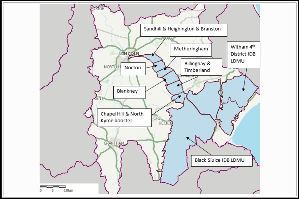
The Witham ALS contains 3 Level Dependent Environments (LDE):
- the Witham First
- the Witham Fourth
- Black Sluice
These are shown in Map 8. We have divided these areas into units, known as Level Dependent Management Units (LDMU’s) (see Table 3). We have completed an assessment on each of these units.
Table 3: Level dependent environments and management units in the Witham ALS area
| Level Dependent Environment | Associated Level Dependent Management Units |
|---|---|
| The Witham First | Sandhill, Heighington & Branston |
| The Witham First | Nocton |
| The Witham First | Metheringham |
| The Witham First | Blankney |
| The Witham First | Timberland and Billinghay |
| The Witham First | Chapel Hill and North Kyme Booster |
| The Witham Fourth | The Witham Fourth |
| Black Sluice | South Forty Foot |
The Upper Witham and Witham Third IDB areas have not been assessed as LDEs due to their smaller size. Abstractions from these IDB areas will also need a HoL condition relevant to the local level management system. This is agreed following liaison with the relevant IDB. They may also have a HoF condition set at a relevant nearby gauging station.
We will consult the relevant IDB for any licence that is considered in an IDB area. We link our assessment of water resources in the LDEs to the assessment of the main river channels (highland carriers). When considering applying for an abstraction licence in an LDE refer to the water resource assessment in the main river channel (see Table 4).
Table 4: Level dependent environments and associated water resource assessment points in the Witham ALS area
| Level Dependent Environment | Refer to assessment point |
|---|---|
| The Witham First | AP14 Grand Sluice (see Section 4.1) |
| The Witham Fourth | AP9 Bardney and AP14 Grand Sluice (see Section 4.1) |
| Black Sluice | AP7 South Forty Foot Outfall (see Section 4.1) |
The next section provides further information on:
- each of these Level Dependent Environments
- the additional licence restrictions which may apply to new licences in these areas
We determine licence restrictions in the LDMUs will on a case-by-case basis.
Licence restrictions on abstractions in the relation to LDEs in the Witham ALS area
LDE unit 1: The Witham First
The Witham First LDE:
- extends from Lincoln down to Chapel Hill
- is bordered by the Witham to the east and the Lincolnshire Limestone to the west
The area is divided into 6 level dependent management units. A series of highland carriers flow eastward dividing the units. Pumped discharge from the Sandhill, Heighington and Branston LDMU enters the South Delph upstream of Bardney. The remainder of the area discharges to the Witham between Bardney and Grand Sluice.
In most cases licences for abstraction from the Witham First LDE will contain the following conditions:
- a HOF condition set at a relevant gauging station in the Witham
- a site specific HOL condition relevant to the local level management system - agreed following liaison with the relevant IDB
LDE unit 2: The Witham Fourth
The Witham Fourth LDE consists of the east and west fen areas. These areas are drained by an extensive network of drains and sewers under the control of the Witham Fourth IDB. The area mostly comprises Grade 1 Agricultural land. So there is a high demand for spray irrigation water. The levels in the east and west fen areas (and associated drains) are maintained during the summer by transfers from the Lower Witham. Water Transfer Ltd (Boston) manage the transfer of water from the Lower Witham into the Witham Fourth LDE. The Trent-Witham-Ancholme scheme (TWAS) support this transfer. There may be an opportunity to work with others in this catchment to improve water availability.
In most cases licences for abstraction from the Witham Fourth LDE will include a site-specific HOL condition. This is relevant to the local level management system and agreed following liaison with the relevant IDB.
LDE unit 3: The Black Sluice
The Black Sluice LDE contains the South Forty Foot LDMU. The surface waters in this area consist of 2 distinct parts:
- the flowing tributaries which join the South Forty Foot Drain
- the lower level managed main and associated pumped system which drains into the Witham Haven at Black Sluice
In the west of the area is an area of highland underlain by the Lincolnshire Limestone. Flow from the highland areas drains by gravity to the South Forty Foot via a series of highland carriers. The availability of water is determined by the potential storage of surface water in the drainage system. This is influenced by level management in the area and the amount of surface runoff into the system.
Licences for abstraction from the Black Sluice LDE are likely to contain:
- a local HoL condition
- a HoL on the South Forty Foot drain
Refer to section 5.2 approaches to sustainable water management for work that has been done as part of the South Forty Foot priority catchment.
Map 8: Level dependent environments in the Witham ALS
© Environment Agency copyright
4.6 Coasts and estuaries
The River Witham discharges into The Wash embayment via Boston Grand Sluice. The Wash is the largest estuarine system in the UK. It is a mostly shallow embayment where the following rivers drain into the North Sea:
- River Ouse
- River Nene
- River Welland
- River Witham
Between them these rivers drain an area of approximately 15,000 km 2. Marine processes dominate the physical and biological character of the embayment. This is despite freshwater inputs from the very large catchment area. The Wash plays an extremely important role in relation to the wider coastal and marine environment of the region. The value of freshwater flows to The Wash from the smaller drains and creek systems is recognised.
The Wash Site SSSI is located within the embayment. It forms landward borders with Lincolnshire and Norfolk. The SSSI is 63,135 ha in size. It comprises mainly sandflats and mudflats. The SSSI also forms part of:
- The Wash and North Norfolk Coast marine SAC
- The Wash SPA
- The Wash Ramsar site
4.7 Protected areas
The Conservation of Habitats and Species Regulations 2017 (Habitats Regulations) provides a very high level of protection to 2 types of designated sites due to their special environment. These are:
- Special Areas of Conservation (SAC), which contribute to biodiversity by maintaining and restoring habitats and species
- Special Protection Area (SPA), which provides protection to birds and their nests, eggs and habitats
As a matter of government policy Ramsar sites, internationally important wetland sites, are treated in the same way as SACs and SPAs. Ramsars, SACs and SPAs are referred to collectively as European sites. Sites of Special Scientific Interest (SSSI) also carry a high level of environmental importance.
Conservation objectives are the overarching objectives for European and SSSI protected sites to maintain or reach favourable condition. These are set by Natural England. The conservation objectives may consist of qualitative and quantitative descriptions. The process for setting targets that underpin the objectives, is described through JNCC approved ‘Common Standards Monitoring Guidance’ (CSMG). These targets are used by Natural England in assessing the condition of European and SSSI protected sites. These quantitative targets are considered by Natural England as a pre-requisite for achieving the conservation objectives for European or SSSI designated sites.
There are several designated sites of ecological and conservation importance within the Witham ALS area that are water-dependent. The largest of these is The Wash which is described in section coasts and estuaries.
The Witham ALS area also includes a number of water-dependent SSSI sites which could be affected by river flows and abstraction regimes. These include:
- Bardney Limewoods
- Swanholme Lakes
- Tattershall Carrs
Any new abstraction licences with the potential to affect The Wash SPA/SAC will need assessing under the Habitats Regulations.
5. Managing the catchment together
5.1 Action on unsustainable abstraction
Managing water abstraction gives details on:
- what an unsustainable abstraction is
- the measures available to resolve environmental issues caused by abstraction
Actions that we are taking to address unsustainable abstraction, as part of our Water abstraction plan
Taking action to reduce or revoke any unused or partially used licences across the area:
- this is to secure the proper use of water resources
- this has reduced licensed abstraction by 4,277,138 m3/year in the Witham ALS area.
Taking actions under the water industry national environment programme:
- to make sure that water companies take a leading role in addressing unsustainable abstraction
- there is further information on this below
Reviewing time limited licences, adjusting them as necessary to make sure they do not allow environmental damage now or in the future:
- when we consider the renewal of abstraction licences we apply the usual 3 tests of environmental sustainability, justification of need and efficient use of water
- our sustainability test includes considering the risk of environmental deterioration
The Water Framework Directive (WFD) requires that measures are taken to protect and improve the hydrological regime of water bodies. Anglian Water have undertaken options appraisal in the period 2015-2020. This is where abstraction for public water supply is having an impact on river flows. The outcomes of this work are shown for 2 water bodies in the Witham ALS area
River Slea
We have been working with Anglian Water to reduce the impact of their abstraction on the River Slea. After undergoing an options appraisal the preferred solution for these licences was to:
- reduce licence quantities by 3,842,677 m3/year
- implement river support to meet flow targets at Leasingham Mill
The licence changes will be implemented by March 2025.
Barlings Eau
We have been working with Anglian Water to reduce the impact of their abstraction on the Barlings Eau water body. After undergoing an options appraisal the preferred solution for these licences was to:
- reduce licence quantities
- implement river support to meet flow targets on the Welton Beck
The licence changes will be implemented by March 2025.
5.2 Approaches to sustainable water management
Through catchment based working in the South Forty Foot priority catchment we have undertaken a range of initiatives. The South Forty Foot catchment accounts for approximately 20% of the wider Witham catchment.
Map 9: The Witham and South Forty Foot Catchments

© Environment Agency copyright
This section outlines options initiated in this catchment for future approaches to water management. These include collaboration and sharing which may be of interest to both new and existing abstractors.
All year high-flow abstraction
The majority of water users with storage reservoirs in the Witham catchment have historically been permitted to abstract during the period January to March. November and December have sometimes been included. As the climate changes, rainfall patterns are changing. In the Witham Catchment we now welcome applications to fill reservoirs throughout the year during periods of high flows or levels. We have made this decision as we have listened to water users. We will keep this new approach under review. Our permitting decisions will continue to recognise the valuable role that high flows play in the water environment. They will take account of local environmental sensitivities. There is no guarantee that every application will be successful. Depending on the details of a proposal there may also be an increase in water abstraction charges. See the case study for more information.
Case study: Lincolnshire farming business taking steps to improve access to water
During the dry winter of 2018/2019 a Lincolnshire farming business was struggling to fill their winter storage reservoir. This farming business was situated just outside of the South Forty Foot catchment. The business’s water abstraction licence at the time permitted abstraction between December and March. During the spring of 2019 the water user was temporarily permitted to abstract outside of their authorised period of abstraction. Our teams who are responsible for compliance and enforcement led this work. This helped to meet water needs for the summer of 2019. We advised the licence holder to consider applying to permanently vary their licence if they wanted similar flexibility in the future.
The licence holder chose to submit an application to change the:
- abstraction period
- quantity of water abstracted
They employed consultants to assist with the application process.
Following consultation with technical teams and others, including Natural England, we issued a varied licence. This allowed all year abstraction subject to conditions protecting the environment. The varied licence gives the licence holder greater flexibility. It allows them to abstract water to fill their reservoir when the flows are high at any time of year. It is important to note that the charges for the varied licence were increased in line with the current water abstraction charging scheme. The licence holder was willing to pay the increased charges in order to improve their access to water.
Whilst we welcome applications for all year high flow abstraction in the catchment, there is no guarantee that every application will be successful.
The photograph shows an agricultural water storage reservoir with an inlet pipe and a floating off-take.

Developing Water Catchments Resilient to Climate Change
We will continue to work with Lincolnshire County Council and other partners as they work on ‘Developing Water Catchments Resilient to Climate Change’. This work involves:
- environmental monitoring
- installation of new flow gauges in the internal drainage network
- and the development of a new water management hub (shown in illustration).
The project is funded through the European Structural and Investment Fund (ESIF) and partner funding.
Illustration - the Water Management Hub concept

The illustration shows the Water Management Hub concept. Different aspects of water management come together. This is like the spokes of a bicycle wheel joining at the hub. These different aspects (spokes) are:
- water resource module
- water quality module
- integrated water module
- regional planning module
- resilience module
- carbon module
- public value module
- legal compliance module
- environment module
- water transfer module
- trading/sharing module
- pumping module
- gravity-fed module
- water level management module
- water abstraction module
- water demand module
- agriculture module
- economic module
- navigation and marina module
- flood risk management module
- other infrastructure module
Integrated water management is complex. The Hub idea allows people to interact with the management of water:
- from their ‘own’ perspective
- for their ‘own’ purposes
As the hub develops it should help people to realise the value of integration. The hub becomes the ‘place’ where different water management languages are shared. Ultimately this will enable collective, integrated water management decisions to be made.
This is an innovative idea which has emerged as a result of the South Forty Foot priority catchment work. If you would like to know more about this initiative, or share your own perspective, please contact the SLWP via The Black Sluice Internal Drainage Board.
Exploring opportunities to change existing application forms
Following conversations with water users it is clear that some are put off by the application forms. In the South Forty Foot catchment we were keen to see if there are ways we could address this. We listened to an existing licensed water user who was considering proposed licence variations to include:
- a new reservoir
- complex discharge and re-abstraction arrangements
The proposals were complex and difficult to capture on the forms. Could a new form be developed as part of a trial?
Various ideas are emerging. The possibility of a new trial to develop a formal ‘One Change’ application form is being considered. The ‘One Change’ form could complement our existing minor variation and formal application forms in specific situations. Any progress will depend on our ability to maintain the regulatory water resources framework. This protects people and the environment. Get in touch with us (email enquiries@environment-agency.gov.uk) if you would like to know more or if you have any ideas.
Working with natural processes in the catchment
Natural processes help to store water in the ground and slow down the rate at which it enters river systems. Evidence shows that taking action to restore natural processes can help make some catchments more resilient to flood events. We have completed a new study to provide evidence for the benefits of working with natural processes. This will improve resilience to drought.
In the South Forty Foot catchment the study indicated that the following could help, if done in the right places:
- runoff attenuation features
- modification of the lowland drainage system (including peat restoration)
- restoration of headwater channels
Outputs from the project include maps showing where these actions are most likely to be effective. The next step for this work will be to link the findings of this work with other existing work on the ground. This includes:
- the Environment Agency’s Natural Flood Management (NFM) work in the Swaton catchment
- the Black Sluice IDB’s NFM work in the remainder of the approximately 20,000ha Upper Catchment
Engagement with landowners is key. Further details are available in the project report. You can view this on the Priority Catchment Citizen Space.
Future management of water resources in this catchment will focus on:
Developing an efficient, modern regulatory approach in IDB areas
Making water abstraction permitting decisions in flat, low-lying, level managed catchments can be a challenge. Particularly when there are few flow gauges in an area. We often rely on the local understanding and expertise of Internal Drainage Boards as we make our decisions. We are initially working with The Black Sluice IDB to build on our existing regulatory approach. The aim of this work is to help the following understand the way we manage water in different sub-catchments:
- water users
- the IDB
- local technical teams
- our National Permitting Service
This will help us to make efficient, robust permitting decisions. So delivering good outcomes for people and the environment.
Anglian Water and Affinity Water’s South Lincolnshire Reservoir
We will continue our work with the water companies as they develop the South Lincolnshire Reservoir strategic water resource option. This is through Ofwat’s RAPID process. We will fulfil an important local and national regulatory role in this. We are also playing an active role in shaping the option through our involvement in The South Lincolnshire Water Partnership. We are keen to see integrated water management outcomes which deliver benefits for all sectors. We are continuing stakeholder collaboration.
A strategic reservoir in the area could lead to significant new demands for water from:
- the Witham and South Forty Foot catchments
- other neighbouring systems
South Lincolnshire Water Partnership - system operator ideas
We are keen to continue engagement with The South Lincolnshire Water Partnership (SLWP) as they develop catchment ‘system operator’ ideas. These ideas could tie in with The Defra 25 Year Environment Plan. There are some interesting conversations about future financing of water management activities at a landscape scale. There will be opportunities to link these ideas to an Environmental Land Management Scheme (ELMS) pilot. This is being led by The Lincolnshire Wildlife Trust in the catchment.

The photo shows people attending a breakfast event. We invited people to share their thinking. This event took place at the start of the South Forty Foot priority catchment work.
The priority catchment initiative has also been running elsewhere in England. You can find more information on work in the updated ALS for the catchments:
5.3 Water rights trading
We want to make it easier to trade water rights. A water rights trade is where a person sells all or part of their water right, as defined by their abstraction licence(s), to another person on a permanent or temporary basis. In the majority of cases a trade will involve a change in abstraction location and/or use. We will need to approve through the issue or variation of abstraction licences.
In licensing trades, as with new abstraction licences, we need to make sure that we don’t cause any deterioration in water body status. This is both:
- within the water body / bodies where the trade will take place
- to downstream water bodies
This section provides a guide to the potential for trading in water bodies of a particular ALS water resource availability colour, as shown on Maps 1 to 4.
To find out more about licence trading go to our water management web pages.
We are currently developing new initatives to support trading in the Witham catchment.
Help for trading water rights map. This helps abstractors to identify potential trades by providing information on:
- nearby licences
- an indication of the potential for a trade
Temporary seasonal trades trial - is designed to help abstractors trade water over a single irrigation season. Abstractors apply for these trades during a defined ‘trading window’ during the spring. This is following publication of the initial irrigation prospects report.
Guide to the potential trading in water bodies of a particular ALS water resource availability colour
High hydrological regime
Blue
Opportunities for trading water rights will be limited.
Water available for licensing
Green
There may be opportunities to allow trades of recent actual abstraction and licensed abstraction. But little demand for trading expected within water body as water available for new abstractions.
Restricted water available for licensing
Yellow
There may be opportunities for licence holders to trade up to their full licensed quantities. But the quantities of water available to trade may be restricted once levels of actual abstraction reach sustainable limits. We will not permit licence trades in water bodies where we are taking action to prevent deterioration unless the trade is consistent with achieving water body objectives.
Water not available for licensing
Red
We will only trade recent actual abstraction but no increase in recent actual abstraction is permitted in water body. Licensed abstraction will be recovered for the environment.
HMWBs
Grey
Opportunities for trading will depend on local operating agreements and local management.
6. Related links
-
Agriculture and Horticulture Development Board (AHDB) website - provides information on effective use of water on livestock farms
-
Catchment Based Approach community website - provides further information on the catchment based approach
-
UK Centre for Ecology and Hydrology Drought Portal - is an interactive portal presenting information on the laterst hydrological situation across the UK
-
Environment Agency, how to apply for a water abstraction or impoundment licence web pages - provide all the information needed to go through the application process to get a licence
-
Environment Agency manage your water abstraction or impoundment licence online web service - allows abstractors to view and share licence information and submit abstraction returns
-
Environment Agency Priority Catchments website - provides further information about the Priority Catchment work
-
The Environment Agency National Framework for Water Resources -explores England’s long-term water needs and the importance of planning at the regional scale and link to the catchment scale
-
Linking Environment and Farming (LEAF) Simply Sustainable Water guide - explains 6 simple steps for managing water quality and use on your land
-
National Farmer’s Union web pages on Irrigation and water resources - provide useful information
-
Natural England’s website - provides further information on protected sites and species
-
Environment Agency and Cranfield University’s guide to planning, designing, constructing and commissioning a water storage reservoir - if you are considering an irrigation reservoir
-
The UK Irrigation Association and Cranfield University - provide a range of irrigation booklets that tackle key issues
-
Waste and Resources Action Programme website has guidance on water efficiency in the food and drink industry
-
Waste and Resources Action Programme website has a guide to water saving devices and practices
7. Glossary
Abstraction - removal of water from a source of supply (surface or groundwater).
Abstraction licence - the authorisation granted by the Environment Agency to allow the removal of water.
Assessment point - a significant point on a river, often where two major rivers join or at a gauging station.
Catchment - the area from which precipitation and groundwater will collect and contribute to the flow of a specific river.
Catchment based approach - partnership working at the river catchment scale to deliver a range of environmental, social and economic benefits while protecting our precious water environments for the benefit of all.
Consumptive abstraction - abstraction where a significant proportion of the water is not returned either directly or indirectly to the source of supply after use. For example for the use of spray irrigation.
Discharge - the release of substances (for example, water, treated sewage effluent) into surface waters.
Environmental flow indicator - flow indicator to prevent environmental deterioration of rivers, set in line with new UK standards set by UKTAG.
Groundwater - water that is contained in underground rocks.
Hands off flow - a condition attached to an abstraction licence which states that if flow (in the river) falls below the level specified on the licence, the abstractor will be required to reduce or stop the abstraction.
Impoundment - a structure that obstructs or impedes the flow of inland water, such as a dam, weir or other constructed works.
Surface water - this is a general term used to describe all water features such as rivers, streams, springs, ponds and lakes.
Water body - units of either surface water or groundwater which we use to assess water availability.
8. Copyright - map images
© Environment Agency copyright and/or database right 2020. All rights reserved. This map includes data supplied under licence from: © Crown Copyright and database right 2020. All rights reserved. Ordnance Survey licence number 100024198.
9. Contact details for further information
For local water resources advice contact the Lincolnshire and Northamptonshire Integrated Environmental Planning Team. You can either call or email the team:
- call 03708 506 506 (calls cost no more than a national rate call to on 01 or 02 number)
- email enquiries@environment-agency.gov.uk