Thames Estuary 2100: 15-year monitoring review (2026)
Published 6 August 2026
Applies to England

© Crown copyright 2026
This publication is licensed under the terms of the Open Government Licence v3.0 except where otherwise stated. To view this licence, visit nationalarchives.gov.uk/doc/open-government-licence/version/3 or write to the Information Policy Team, The National Archives, Kew, London TW9 4DU, or email: psi@nationalarchives.gov.uk.
Where we have identified any third party copyright information you will need to obtain permission from the copyright holders concerned.
This publication is available at https://www.gov.uk/government/publications/thames-estuary-2100-15-year-monitoring-review-non-technical-summary/thames-estuary-2100-15-year-monitoring-review-2026
The Thames Estuary 2100 Plan provides recommendations to manage tidal flood risk in the estuary until the end of the century and beyond. It also seeks to enhance the riverside environment, create flood resilient communities, support economic growth and provide environmental net gain. In 2012, the Environment Agency and partners published the Thames Estuary 2100 Plan, which was updated in 2023.
The Thames Estuary 2100 Plan’s area extends from Teddington to the Isle of Grain and Shoeburyness. It covers 27 different local councils across Essex, Kent and London. A tidal flood event poses a significant flood risk for this area. People and property are protected from regular tidal flooding by a system of flood defences.
Unless it is carefully managed, tidal flood risk in the estuary will increase over time. This is due to increased tidal flood risk, population growth and ageing flood defences.
When it was developed, the Thames Estuary 2100 Plan was based on the latest tidal and flood guidance available. The Thames Estuary 2100 Plan is designed to be adaptive. This is because we expect our understanding of impacts of climate change on tidal and flood risk, sea level rise and other factors to improve over time, as new data and scientific evidence become available.
Summary
The Thames Estuary 2100 Plan presents a major opportunity to provide a wide range of benefits as we adapt to climate change.
The results of this review support the current planned interventions for the Thames Estuary flood defence system. However, they also show a need for more regular and detailed checks in some areas.
This monitoring review shows changes in water levels and in the condition of flood defence assets in the Thames Estuary. It also looks at changes in the number of people and properties, along with changes in social, cultural, and commercial value.
Our data clearly shows the acceleration of sea level rise in the estuary. In 2021, the last monitoring review showed that the rate of relative mean sea level rise in the Thames Estuary between 1990 and 2018 was 3.65 millimeters (mm) per year. This was lower than our planning assumption.
In this monitoring review we found that the rate of sea level rise between 1993 and 2024 was 4.10mm per year. The rate of sea level rise now matches the rate predicted in the Thames Estuary 2100 Plan.
While we focus on the Thames Estuary, sea level rise has global, long-term consequences. The projection we use as our planning assumption comes from UKCP18 and predicts a rise in sea levels of over a metre by 2100.
At Southend-on-Sea, the total increase in relative mean sea level between 1911 and 2024 is approximately 0.24 metres (m). Because of the sea level rise that has already taken place, flood defences are having to work harder. Meanwhile, they are ageing, and these factors together have caused a decline in their condition.
There has been ongoing investment in maintaining and renewing flood defence assets in the estuary. However, this level of maintenance is likely to need to increase as assets are used more to reduce flood events and as assets age.
The 15-Year Review found that for fixed flood defences in the Thames Estuary, such as walls or embankments, 96.4% meet their required condition. Compared with similar flood defences across England, of which 92.8% were in the required condition as of April 2025, the Thames Estuary performs well. The Environment Agency has a national target of 93.5% of high consequence flood defences meeting their required condition by the end of March 2027.
We are not currently meeting our 2030 forecast accuracy target for Thames Barrier closures of +0.20m. On average our forecasts are accurate to between +0.3m and +0.4m. +0.2m is the accuracy needed to retain the current deadlines for defence upgrades upstream of the Thames Barrier.
Significant improvements are required to the tidal forecasting system to meet the +0.20m target. If this cannot be achieved in the required timescales, it will result in more closures that may be later found to have been unnecessary.
At the same time, we have shown that the defences are protecting and benefitting more than ever before. More people are living and working within the Thames Estuary, meaning that more property, businesses and people are at risk now than previously from a flood of a given size.
Along with our partners, we are planning for the significant investments and actions needed as we enter the next phase of the Thames Estuary 2100 Plan.
This will include bringing together the full picture of evidence and adapting the Thames Estuary 2100 Plan where necessary to create an estuary that is resilient to tidal flooding and can support sustainable growth.
As part of this we will reassess options for the flood defence system and future of the Thames Barrier itself to increase certainty in how we deliver the Thames Estuary 2100 Plan.
Why do we have a monitoring programme?
To ensure the Thames Estuary 2100 Plan continues to set out the most effective way to manage tidal flood risk, we track a suite of indicators of change. If the estuary is not changing in the way the Thames Estuary 2100 Plan predicts, we may need to put in place its recommendations earlier or later than planned. This could also alter the recommended options. We carry out a monitoring review every five years and a full review of the Thames Estuary 2100 Plan at least every 10 years.
We originally identified 10 high-level indicators to track physical and socio-economic changes in the Thames Estuary. However, for the 15-Year Monitoring Review, we focused on the most critical indicators before the next full Plan review, which is expected to start by 2030.
These critical indicators were:
- sea level and extreme water levels
- fluvial flows
- condition of flood defences
- barrier operations
- people, property and critical infrastructure
- social, cultural and commercial value of the estuary
We recommend that the 20-Year Monitoring Review, part of the next full Plan review, looks at all change indicators. This will ensure there is a complete suite of evidence on changes in the Thames Estuary to support robust decision-making.
It should include changes in erosion and deposition, the area of designated intertidal habitat, and attitudes towards flood risk among people and organisations in the estuary. These were last reviewed in the 10-Year Monitoring Review in 2021. The 20-Year Monitoring Review will help make key decisions about upgrades to the flood defence system.
Critical indicators: overview
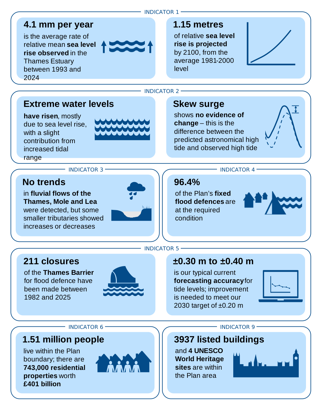
Infographic shows the following critical indicators of change overview.
Indicator 1: sea level rise
4.1mm per year is the average rate of relative mean sea level rise observed in the Thames Estuary between 1993 and 2024.
1.15 metres of relative sea level rise is projected by 2100, from the average 1981 to 2000 level.
Indicator 2: extreme water levels
Extreme water levels have risen, mostly due to sea level rise, with a slight contribution from increased tidal range.
Skew surge shows no evidence of change - this is the difference between the predicted astronomical high tide and observed high tide.
Indicator 3: fluvial flows
No trends in fluvial flows of the Thames, Mole and Lea were detected but some smaller tributaries showed increases or decreases.
Indicator 4: condition of flood defences
96.4% of the Plan’s fixed flood defences are at the required condition.
Indicator 5: barrier operations
211 closures of the Thames Barrier for flood defence have been made between 1982 and 2025.
±0.30m to ±0.40m is our typical current forecasting accuracy for tide levels; improvement is needed to meet our 2030 target of ±0.20m.
Indicator 6: people, property and critical infrastructure
1.51 million people live within the Plan boundary; there are 743,000 residential properties worth £401 billion.
Indicator 9: social, cultural and commercial value of the estuary
3937 listed buildings and 3 UNESCO World Heritage sites are within the Plan area.
Sea level and extreme water levels
We monitor how both average and very high sea levels are changing. This helps us to understand when to upgrade flood defences downstream of the Thames Barrier. It also identifies when major actions, like upgrading the Thames Barrier or building a new one further downstream, are necessary.
Sea levels in the Thames Estuary have risen significantly over the last century. At Southend-on-Sea, sea level rose by about 25 cm between 1911 and 2024.
Between 1990 and 2018, the rate of sea level rise in the estuary was 3.65mm per year. From 1993 to 2024, sea level across the estuary rose by about 4.10mm per year, which matches the projection in the Thames Estuary 2100 Plan.
Rising sea levels are causing higher extreme water levels, increasing flood risk. Storm surges are short-term sea level changes caused by low pressure systems. They can lead to extreme water levels.
Our analysis did not find clear evidence that the storm surge component of extreme water levels is worsening. However, another recent study did find such evidence. Because of this uncertainty, the storm surge element should be looked at again in the Thames Estuary 2100 Plan’s 20-Year Review.
More frequent monitoring of sea level rise, above that of our current 5-yearly programme, would improve our understanding of whether the recent faster increase is ongoing or just a short-term change.
The Thames Estuary 2100 Plan was originally designed to cope with a sea level rise scenario that was considered a plausible worst-case. Since then, an updated worst-case scenario has been published, led by researchers at the Met Office, and it will be considered in future work.
Fluvial flows
Fluvial flow describes the movement of water in a river or stream.
There has not been a statistically significant change in flows in the Thames, nor in the two largest tributaries (the Mole and Lea). Among the other tributaries, five saw increased flows, three had decreases, and eight showed no significant change.
These trends aren’t necessarily linked to climate change. Flows are mainly influenced by human factors. An example of this is urban runoff, which occurs when stormwater and irrigation run off hard surfaces into drains, rivers, and streams. It is therefore uncertain whether these trends will persist.
New estimates for future increases in flows with climate change have recently been released. For flows entering the Thames Estuary 2100 Plan area, these are generally higher than in previous guidance used, particularly for the 2070 to 2115 period.
Compared to previous, new projections are between 0 and 12 percentage points higher, depending on the time period and the climate change allowance. This suggests that peak water levels in areas further upstream of the Thames may become higher than previously anticipated.
Modelling is currently being carried out by the Environment Agency to better understand how much levels could be affected and how this will impact the Thames Estuary 2100 Plan.
We’ve used this information to improve our planning for future defence upgrades in the estuary. We are progressing similar studies to predict when the Barking Creek Barrier and Dartford Creek Barrier might close. This will help us set deadlines for upgrading those defences.
Condition of flood defences
We monitor the condition of all fixed flood defences, like walls or embankments, in the estuary. We own approximately 1% of these assets. However, we maintain 13% of them, which accounts for 43% of the fixed tidal flood defences by length. Responsibility for the other assets lies with a range of organisations and landowners, with whom we need to work in partnership.
Most fixed flood defence assets are in good condition, but the number currently meeting their required condition has decreased since the 10-Year Monitoring Review in 2020. It now stands at 96.4%, compared with 97.5% in the 10-Year Monitoring Review. For active assets, which have one or more moving parts, 85% of those whose condition is known are in fair or better condition.
Across the Environment Agency, we are replacing the long-standing ‘Asset Condition’ metric, which uses a 1 to 5 visual grade. Our new ‘Asset Health’ score will show the likelihood of failure, based on a suite of asset health indicators. Assets below their target condition should still be reviewed, with improvements prioritised. For flood defences managed by third parties, we will collaborate with asset owners to find suitable solutions.
To understand how effective our flood defences are, we are updating crest level data for fixed defences downstream of the Thames Barrier. A crest level is the level at the top of a flood defence, such as the top of a wall or embankment. Further projects will cover the remaining assets.
If any assets are below their design crest level, they may need to be upgraded to maintain the level of flood protection. In some cases, depending on the risk level, they may need remediation work sooner.
Barrier operations
The number of Thames Barrier closures needed changes each year. This variation is due to a combination of closures resulting from both: a) fluvial floods from rainfall b) storm-surge and long-term tidal cycles.
There has been a small but statistically significant increase in the number of individual storm tides or periods of high river flow that require one or more closures since the first closure in 1982.
Accurate forecasting is critical to the operation of the Thames Barrier and to avoid closing it more often than necessary.
Currently, our forecasts are within about 30 to 40 centimetres (cm) of the observed water level, but our target is to improve accuracy to 20cm by 2030.
Forecasting future closure numbers helps us understand when further improvements to the flood risk management system might be needed.
People, property and critical infrastructure
The number of people living within the area of the Thames Estuary 2100 Plan has increased by 21% to 1.51 million compared to the Thames Estuary 2100 Plan’s original data from 2009. During this time, the value of residential property in the Thames Estuary 2100 Plan area rose by 101% to £401 billion.
The increase is due to the greater number of properties and rising prices. This means the tidal defence network now protects more people than ever before and offers greater economic benefits for London, Essex, and Kent.
Factors that affect an area’s vulnerability to flooding include population, age and socio-economic status. The areas with the highest proportions of young children and older adults are located downstream of the Thames Barrier.
Children aged 0-4 represent over 7.25% of the population in: Purfleet, Grays and Tilbury; Swanscombe and Northfleet; Dartford & Erith; and Barking & Dagenham. Adults aged 75+ represent over 9.7% of the population in Canvey Island and Bowers Marshes.
Approximately 23.5% of the population downstream of the Thames Barrier are in low-income jobs, compared with 15.8% of those living upstream. This means areas downstream of the barrier may be more vulnerable to flooding than those upstream.
Social, cultural and commercial value of the estuary
It is important to protect the many community assets and cultural heritage sites within the Thames Estuary boundary.
Acting on the Thames Estuary 2100 Plan should reduce flood risk for people, property, and infrastructure. It aims to create social, cultural, and commercial benefits for communities. It also supports resilient economic growth in the Thames Estuary.
The Thames supports significant commercial activity with the transport of people and goods. Recent investments in ports, vessels, and light freight infrastructure demonstrates the potential for further growth.
When choosing a long-term flood risk management strategy, like a future barrier location, we must consider the estuary’s role in shipping and recreation. This is especially important as extreme water levels cause more frequent barrier closures.
Since the 10-Year Monitoring Review in 2021, more people are using the river for recreation. At the same time, public parks have shrunk, showing a need for better access to the river and more green spaces. Also, the Index of Multiple Deprivation shows that some of the most deprived 10% of areas in England exist within the Thames Estuary 2100 Plan boundary. This presents an opportunity for the Thames Estuary 2100 Plan’s riverside strategy approach to benefit local communities and support economic growth.
The Thames Estuary 2100 Plan’s riverside strategy approach supports providing flood defence upgrades as part of broader plans for growth and redevelopment. This benefits communities socially, culturally, and commercially. Local communities and river users should take part in creating these strategies.
Right now, only the City of London has a riverside strategy. However, work is ongoing to develop strategies for the rest of the estuary.