Post-incident reporting for reservoirs: annual report 2021
Updated 7 October 2024
Applies to England

© Crown copyright 2024
This publication is licensed under the terms of the Open Government Licence v3.0 except where otherwise stated. To view this licence, visit nationalarchives.gov.uk/doc/open-government-licence/version/3 or write to the Information Policy Team, The National Archives, Kew, London TW9 4DU, or email: psi@nationalarchives.gov.uk.
Where we have identified any third party copyright information you will need to obtain permission from the copyright holders concerned.
This publication is available at https://www.gov.uk/government/publications/reservoir-safety-post-incident-annual-reports/post-incident-reporting-for-reservoirs-annual-report-2021
1. Foreword
We publish this report so that those involved in reservoir safety can learn from past incidents. By sharing experiences, we can improve safety for the future. This is important as we face new challenges from the impacts of climate change on our aging reservoirs.
Surveillance, monitoring and good ownership practises are key in reducing incidents at reservoirs. In June 2022, we published new guidance. This helps undertakers (owners and operators) and engineers when supervising, inspecting and carrying out any safety repairs.
The new guidance can be found here:
- Reservoir supervising engineers: written statements and site visit reports
- Reservoir inspecting engineers: inspecting high-risk reservoirs
- Reservoir owner and operator guidance: spillways
The next report (2022) may look different as we seek to put in place changes following the recent government legislation review. How we share learning from incidents needs to be more coordinated. We will work with colleagues around the world in finding better ways to do this.
So, please continue to help by reporting all incidents no matter how small or insignificant they may appear.
Antony Deakin, Reservoir Safety Manager, Environment Agency
2. Executive summary
For this report the Environment Agency received final information on 5 incidents that occurred during 2021.
Incidents are classified by their level of severity. The 3 levels are:
- 1 (failure)
- 2 (emergency works)
- 3 (precautionary or unplanned works)
For more details on the classification system, see section 3.1 in this report, ‘Incident classification levels’.
One incident from 2021 was classified as level 2. The other 4 were classified as level 3 incidents.
During 2021 the Environment Agency also received final information on 6 incidents from 2019 and 5 incidents from 2020. All of the incidents from 2019 and 2020 were classified as level 3.
It is not unusual for reports to include information from previous years. This is because reservoir undertakers have 12 months to provide a full and comprehensive post-incident report.
A qualified civil engineer, appointed by the Secretary of State for Environment, Food and Rural Affairs, reviews all incidents. The incidents in this report are either resolved or have plans in place to address any outstanding issues.
Each case study in the report contains important lessons learned for each incident.
The Environment Agency would like to thank the undertakers and engineers who have given permission for photographs they supplied to be used for this report.
3. Reporting incidents in England
On 31 December 2021, 2,116 reservoirs were classed as statutory large raised reservoirs in England. A large raised reservoir is a reservoir which can hold over 25,000 cubic metres of water above natural ground level. This is similar to 10 Olympic-sized swimming pools. A small raised reservoir holds less than 25,000 cubic metres.
Since July 2013, undertakers of large raised reservoirs in England must report any incidents to the Environment Agency. This is a requirement of the Reservoirs Act 1975 and Regulation 14 of Statutory Instrument 2013 No. 1677. Undertakers of small raised reservoirs can voluntarily report incidents. As soon as an incident is under control, the reservoir undertaker must provide a preliminary report to us. This report must contain:
- the date and time of the incident
- the location of the reservoir
- incident details (observations)
The reservoir undertaker must send the Environment Agency a final post-incident report form within a year of the incident. The report must contain:
- information about the facts relating to it
- analysis of its circumstances
- any conclusions
- any lessons learned from the incident
The Environment Agency reviews the final report. We will seek further clarification from the undertaker as necessary.
We assign an incident number when the undertaker reports an incident to us. Incident numbers may not be in numerical or chronological order in this report. This is because:
- some incidents are not classed as reportable incidents, so the incident number is removed and not re-allocated
- in some cases, we wait until the undertaker completes a full investigation of the causes before allocating an incident number
This reporting process is separate to any incident response.
If you have concerns about the operation of a reservoir you should report it immediately to the Environment Agency on the incident hotline: 0800 80 70 60.
3.1 Incident classification levels
The Environment Agency classifies incidents according to the level of severity. There are 3 levels.
Level 1
This is a failure, which is an uncontrolled sudden large release of retained water.
Level 2
This is a serious incident involving any of the following:
- an emergency drawdown
- emergency works
- a serious operational failure in an emergency
Level 3
Any incident involving:
- a precautionary drawdown
- unplanned physical works
- human error leading to a major (adverse) change in operating procedures
All these incident categories are covered by the regulations.
4. Reported incidents overview
This year the Environment Agency received final information for:
- 5 incidents that occurred in 2021
- 5 incidents that occurred in 2020
- 6 incidents that occurred in 2019
Two incidents took place at small raised reservoirs, the others at large raised reservoirs.
The Environment Agency seeks advice from an independent qualified civil engineer to classify the incidents. Following this advice, for final information received in 2021, we classed:
- 1 incident in 2021 as level 2
- 4 incidents in 2021 as level 3
- 5 incidents in 2020 as level 3
- 6 incidents in 2019 as level 3
The incidents in this report are either resolved or there are plans in place to address outstanding issues.
5. 2019 incidents
5.1 Incident 465
Dam type: earthfill embankment.
Reservoir legal status: statutory (large raised reservoir).
Dam height: 3.65 metres (m).
Incident type: other.
Incident severity: level 3.
This was an operational incident which occurred at a flood storage reservoir. The reservoir protects properties between the reservoir and an estuary. Depending on the flow rate and tide level, the reservoir pumps water downstream, or releases it through a penstock by gravity. The reservoir held more water than usual due to faulty sensing and control equipment. The penstocks failed to operate correctly in response to water level sensor information. A webcam surveillance system detected the abnormally high levels.
The problems with the sensors impaired the effective operation of the reservoir. No serious consequences occurred, but the incident could have reduced the safety of the reservoir.
Lessons learned
An investigation identified several factors leading to the incident. After a control panel refit, the water level sensors had not been set up correctly. This had reversed the reservoir levels and downstream river levels on the sensor. As a result, the river level threshold, which opened the penstock, was not reached.
The investigation also found other problems which delayed the resolution of the problem. Sensors which controlled the downstream pumps went out of range. This disabled automatic pumping. The automatic penstock had failed in the closed position a week earlier. The gearbox was running but not engaging with the penstock and failing to generate an alarm. This meant the release of water into the estuary relied on the pumps. The failure of the instrumentation had led to the closure of a penstock at the dam. This had caused the reservoir to fill. Manual intervention was necessary to drain the water downstream of the dam.
Following the investigation, the operator reconfigured the water level sensors and alarms. They repaired the penstock and installed further instrumentation. This will improve the resilience of the control system.
5.2 Incident 466
Dam type: earthfill embankment.
Reservoir legal status: statutory (large raised reservoir).
Dam height: 2.4m.
Incident type: erosion or sinkhole.
Incident severity: level 3.
This incident occurred at an offline flood storage reservoir. A railway embankment separates the reservoir area from the main watercourse. A wall protects the toe of the embankment on the main river side.
Erosion had damaged the wall leading to destabilisation of the railway embankment. The reservoir was not in flood at the time. If the reservoir had filled, failure could have occurred through the damaged section of the embankment. The reservoir operators prevented the reservoir from filling until the embankment was repaired.
Lessons learned
A railway inspector noticed the damage to the embankment, rather than the reservoir operators. Vegetation growth made identifying the condition of the wall difficult.
The incident highlights the need for effective surveillance regimes. It also highlights the challenges of incorporating existing infrastructure into reservoir design – in this case, the railway embankment. This is particularly the case when there is poor information on the design and construction of the existing infrastructure. Access and permissions for monitoring and maintaining these structures may also be difficult.
5.3 Incident 467
Dam type: earthfill embankment.
Reservoir legal status: statutory (large raised reservoir).
Dam height: 5m.
Incident type: uncontrolled flow.
Incident severity: level 3.
This incident occurred at a control structure. It diverts floodwater from an online flood storage reservoir to an offline storage area.
An online flood storage reservoir is usually created by building a dam across the watercourse. An offline flood storage reservoir is located next to the watercourse, connected to it by spillways or pipes.
At this reservoir, 2 screw shafts lift the control gate, one on each side of the gate. A connection on one of the shafts sheared, which stopped the gate operating. The reservoir operator installed stoplogs to isolate the gate for investigations and repairs.
Remote monitoring by level sensors and programmed alarms (telemetry) alerted the owner. This allowed a fast response.
Lessons learned
The gate had been in operation for almost 50 years and was regularly tested, performing well. The remote sensing of the structure notified the undertaker immediately of a problem. This highlights the value of such sensing systems.
Gate operators should consider periodic reviews of gates by mechanical and electrical engineers. The review should use available operational information and include a physical inspection. It should advise undertakers if components or the whole gate needs replacing. This is especially important where effective operation may be critical to reservoir safety.
5.4 Incident 468
Dam type: earthfill embankment.
Reservoir legal status: statutory (large raised reservoir).
Dam height: 19m.
Incident type: internal erosion.
Incident severity: level 3.
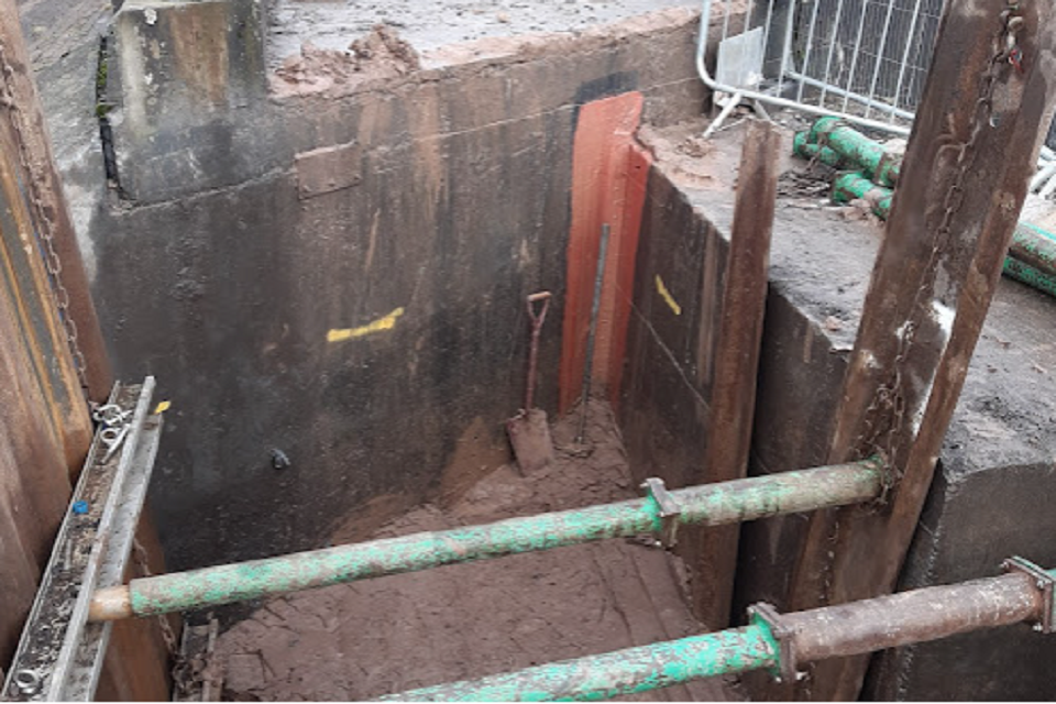
The supervising engineer identified seepage from drains flowing on the downstream face of a concrete spillway. The spillway was built in 1991. Monitoring of the drains showed that the flow rate varied with the reservoir’s water level.
The downstream face of the central spillway wall has several wall drains. There is also a drain to the left and the right of the central spillway wall, below the top of the spillway. No flow was observed from the central drains or the one on the left. An increase in flow was observed in the right hand drain when at top water level. The flow was ochreous, flowing orange. The flow at the toe of the spillway wall was obscured by vegetation.
The reservoir operators raised concern that the leakage could lead to internal erosion. This erosion would most likely be next to the concrete side walls of the spillway. They reduced the water level to investigate the problem.
They placed material between the spillway concrete side walls and the reinforced concrete structure supporting the clay core. This support formed ‘nibs’ (protrusions), designed to hold the fill material in place.
Settlement had caused a gap to open up between the spillway structure and the concrete nibs. This was the likely cause of the leakage.
Further investigation found that granular fill put behind a row of sheet piles during construction was not removed.
Remedial works involved:
- removing the granular material
- sealing the interface between the concrete nib and the embankment
- backfilling with puddle clay
The photograph shows the sealing of the interface between the concrete nib and backfilling with puddle clay.
"
Lessons learned
Central spillway structures on embankment dams pose challenges. The Toddbrook incident in 2019 demonstrated this. See the Toddbrook reservoir incident: independent review for further information on this incident. The design and construction of concrete spillway structures on embankment dams warrant careful monitoring and surveillance.
In this case the drains that started to show leakage had not been subject to formal monitoring. The investigation found that the improvements to the material on the upstream side of the core were not satisfactory. The design had not considered the impact of long-term movement between the spillway side walls and the concrete nibs.
The incident highlights the importance of:
- understanding the design of structures
- as-built drawings
- routine surveillance by trained personnel
5.5 Incident 469
Dam type: earthfill embankment.
Reservoir legal status: statutory (large raised reservoir).
Dam height: 4m.
Incident type: erosion or sinkhole.
Incident severity: level 3.
The dam crest collapsed, revealing a void in an embankment dam.
The dam dates from 1755 and has a masonry wall on the downstream side with earthfill forming the body of the dam. Although an old dam, it had only recently been registered as a statutory reservoir.
The undertaker used pumps to lower the reservoir water level. This revealed the void was approximately 2 metres by 2 metres wide and 1 metre deep. The undertaker (in consultation with a qualified civil engineer) undertook remediation works. They filled the void with clay and topped up the crest with topsoil to the required height.
Investigations revealed a low level culvert through the dam. A small shaft within the upstream shoulder served the culvert. The outlet to this culvert was through the downstream masonry wall. Internal erosion along the line of the culvert may have led to the creation of the void. The undertaker inserted a steel pipe into the outlet of the culvert and used concrete around it to seal it. They monitored flows from the pipe over several months. They also installed a new cut-off trench in the upstream shoulder of the dam.
Lessons learned
This incident highlights the challenges of old dams which do not have available records and drawings. The deterioration of buried structures can cause internal erosion. Geophysical surveys can be useful at old dams when detailed design information is not available. They can identify the position of buried structures and variations in the dam body. This can help inform risk assessments. They can also show where to do more detailed intrusive investigations to manage risk.
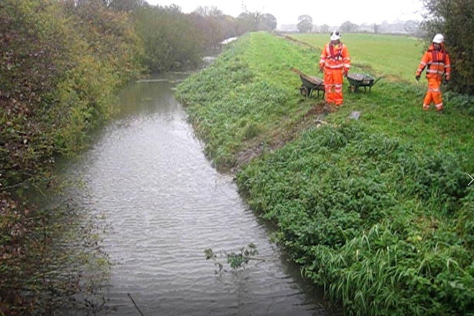
5.6 Incident 470
Dam type: earthfill embankment.
Reservoir legal status: statutory (large raised reservoir).
Dam height: 8m.
Incident type: spillway damage.
Incident severity: level 3.
This incident happened at a central overflow spillway. Concrete slabs form the spillway on the downstream face of the embankment. When overflowing, jets of water rose from some areas of the joints in the concrete slabs.
The undertaker kept the water level low as a precaution. This reduced the risk of overflow and allowed safe access for inspection. The inspection found that the joint bonding material had deteriorated. This deterioration caused the disruption to the flow pattern. Some minor areas of raised concrete were also found. Reference to the design drawings by a qualified civil engineer indicated no wider concern with the design of the spillway slabs. The undertaker undertook extensive remedial works. These included grinding the raised concrete down and replacing the de-bonded sealant.
Lessons learned
The incident occurred in the months following the Toddbrook incident. It further reinforces the need for regular inspections of spillway structures. This allows fast identification and remediation of defects.
On large chutes some alterations may create safer access for inspection staff. These alterations would be site-specific and they would need to be discussed with a qualified civil engineer.
6. 2020 incidents
6.1 Incident 471
Dam type: earthfill embankment.
Reservoir legal status: statutory (large raised reservoir).
Dam height: 11.5m.
Incident type: leak by pipe or culvert.
Incident severity: level 3.
This reservoir has an elevated feeder channel upstream of the main reservoir body. The incident happened on the embankment of this channel. When the reservoir water level is high, the feeder channel also fills.
During routine surveillance of this embankment, an inspector heard water running into a ditch on the downstream side. They found water running into a 300 millimetre (mm) diameter clay land drain. The drain provides cross drainage under the feeder channel.
They found an area of leakage on the upstream face of the embankment. The source was the feeder channel. Without intervention, earth from the embankment would have washed into the land drain. This could have destabilised the embankment.
The operators lowered the water level in the reservoir. They kept the level lower than 1m below the top water level. They filled the area of leakage in the feeder channel with clay as a temporary solution. They surveyed the pipe using CCTV, and patch repaired the pipe.
This photograph shows the feeder channel embankment following a temporary repair.
"
Lessons learned
It is unclear what caused the leakage from the feeder channel into the land drain. Heavy rainfall in the weeks before the incident could have deteriorated the pipe. At the time of the incident the reservoir had recently been filled to top water level. This was after a summer of low water levels. Cracking of the clay in the feeder embankment may also have contributed.
The condition of this land drain and 2 others are now specifically inspected during routine visits.
6.2 Incident 472
Dam type: earthfill embankment.
Reservoir legal status: statutory (large raised reservoirs).
Dam height: 2.3m.
Incident type: trees or vegetation.
Incident severity: level 3.
High winds uprooted a large beech tree on the crest of an embankment dam. The damage to the crest covered approximately 6m in diameter and disturbed the fill to a depth of up to 700mm. The undertakers drew down the water level as a precaution. They maintained a low level until they had completed the repairs.
This photo shows the fallen tree on the embankment crest.
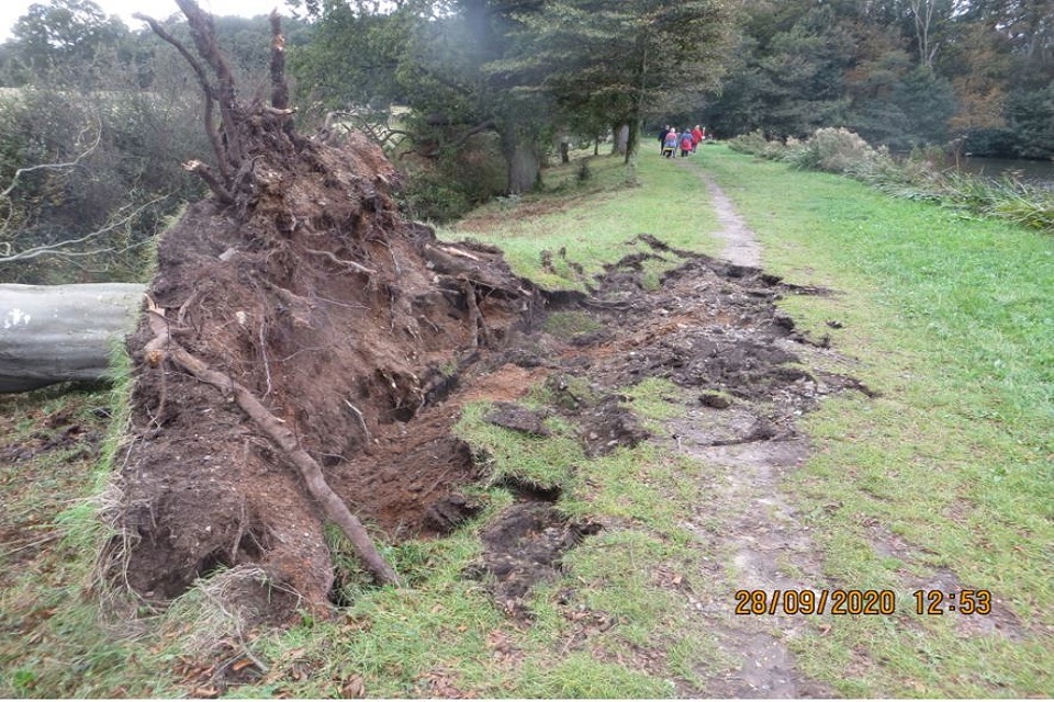
"
Lessons learned
Investigations found that the tree had a form of fungal disease, although the high wind was the main cause of its fall.
Other trees on the dam were also infected by the fungus, but the owners had previously reduced their size. This reduced the risk of damage in high wind. The broadness of the crest and shallowness of the tree roots reduced the impact of the treefall. Under different circumstances the event could have caused the embankment to breach.
Dam owners should ensure that the health of mature trees on dam embankments should be reviewed periodically by specialists. They should also reduce the size of trees that are susceptible to wind damage. This should also occur when their location on the dam poses a threat to the embankment. This is important because strong wind events will become more common due to climate change.
6.3 Incident 473
Dam type: earthfill embankment.
Reservoir legal status: non-statutory (small raised reservoir).
Dam height: unknown.
Incident type: flood overflowing.
Incident severity: level 3.
This incident occurred at a small non-impounding reservoir. It stores digestate slurry which is applied to the surrounding fields each spring. It is not a statutory reservoir.
An earth embankment with a clay core forms the reservoir. The reservoir is filled by pumping and by direct rainfall. After heavy rain, a member of the public reported leakage at the toe of the embankment. An investigation found the leak was through the top of the crest, above the top of the clay core.
The leachate (contaminated water) level was approximately 100mm below the top of the crest. Staff on site observed flow on the downstream face of the embankment. They pumped the reservoir into tankers, reducing the level to 600mm below the dam crest.
A temporary catch pit held the leachate before it could be pumped. This prevented contamination of the local watercourse.
No permanent damage to the embankment occurred as a result of the incident.
Lessons learned
This incident highlights the importance of surveillance at small non-impounding reservoirs. Particularly as they often have no overflow facility. Pumping too much water into the reservoir or severe direct rainfall can lead to failure.
In this case, any overflow could also have caused a pollution incident. Non-impounding reservoirs should be inspected on a regular basis. The inspection should verify the reservoir level and check the condition of the embankment and other structures. Reservoir undertakers can install water level sensors, and alarm systems are available to guard against overfilling.
6.4 Incident 474
Dam type: earthfill embankment.
Reservoir legal status: statutory (large raised reservoir).
Dam height: 3m.
Incident type: erosion or sinkhole.
Incident severity: level 3.
This incident involved a concrete sluice structure through an earth embankment. It separates 2 flood storage reservoirs. Under flood conditions the embankment overflows. Operation of the penstock (sluice structure) controls flood levels either side of the embankment. During a flood event the sluice structure was open. Drone imagery of the structure identified turbulence close to the structure. The operators closed the sluice gate.
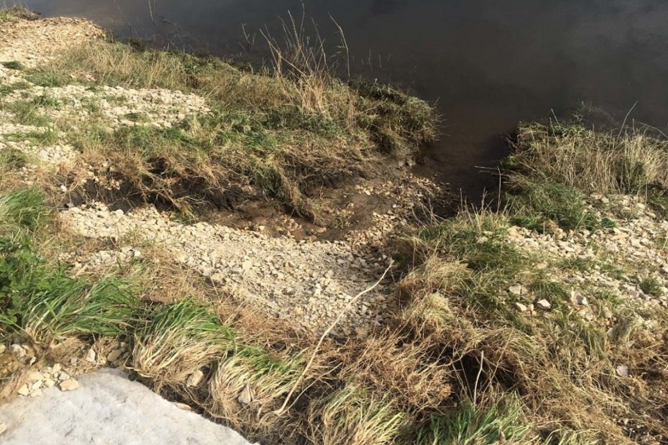
An inspection of the structure found erosion of the embankment next to the flared sheet pile wingwalls on both sides of the structure.
The undertaker made temporary repairs before installing permanent repairs. The permanent repairs involved adding hard surface protection to the:
- embankment crest
- downstream slope
- toe area of the embankment
This was to prevent the erosion from occurring again.
This photo shows erosion next to the penstock wingwall.
"
Lessons learned
The incident happened due to turbulence and erosion. This had not been adequately allowed for in the design of the structure.
It is important for designers to evaluate the impact of turbulence in all likely flow conditions. This is particularly true at points of concentrated flow next too erodible surfaces.
Images of the damaged embankment suggest that rows of sheet piles in the embankment restricted the extent of the damage. This was fortunate and shows an element of good design.
6.5 Incident 475
Dam type: earthfill embankment.
Reservoir legal status: statutory (large raised reservoir).
Dam height: 3m.
Incident type: flood overflow.
Incident severity: level 3.
A severe flood event damaged a long, low earth embankment. It connected the riverside embankment of a flood storage reservoir and a barrier bank. It is designed to overflow during flood events. A 250mm granular stone on top of geotextile membrane forms the crest.
During the incident, 500mm of water overflowed the bank. This damaged the embankment by causing erosion to the crest and downstream face. It pulled the geotextile membrane from the embankment face and across the crest. The undertaker left a penstock (sluice gate) open. This attempted to equalise the water level to reduce the stress on the bank.
Following temporary repairs, the undertaker improved the embankment. They used a hard surfacing on the crest and upper sections of the upstream and downstream banks.
This photo shows the erosion on the downstream face of the embankment.
"
This photo shows the damaged geotextile membrane, where it was moved by the overflowing water across the crest.
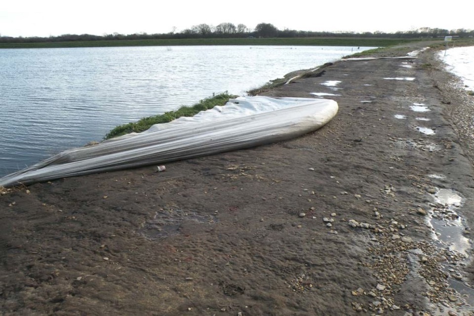
"
Lessons learned
The investigations led to 2 main findings.
Firstly, the geotextile was not anchored into the embankment. This made it susceptible to movement when water overflowed the embankment. Designers should consider the erosion resistance of materials on embankments. This is particularly true when banks are designed to overflow.
Secondly, the grass cover on the downstream face was irregular. There were many animal burrows, which weaken the embankment. Grassed embankment surfaces need careful maintenance. They should have an even profile and undertakers should control animal activity.
7. 2021 incidents
7.1 Incident 476
Dam type: earthfill embankment.
Reservoir legal status: statutory (large raised reservoir).
Dam height: 5.5m.
Incident type: other.
Incident severity: level 3.
This incident occurred at an earthfill embankment made of peaty fill material. It is in a peat moorland.
After some very dry weather, there was a fire on the moorland. It is assumed picnickers may have started the fire. The fire spread to one section of the dam. There was a concern that the fire may have affected the safety of the dam. The undertakers drew down the reservoir as a precaution. They damped down the affected area of the dam.
Lessons learned
An investigation found the fire had scorched some of the grass on the dam face.
The undertaker excavated several trial pits. They found there was only peaty fill in some areas. The fire had scorched the drier, non-peaty soil more than the wetter peat.
A qualified civil engineer considered the embankment safe without changing the fill. The owner intends to improve the grass by using a different, less flammable grass type.
7.2 Incident 477
Dam type: earthfill embankment.
Reservoir legal status: non-statutory (small raised reservoir).
Dam height: unknown.
Incident type: flood overflowing.
Incident severity: level 2.
This incident occurred at a former gravel pit area within a wide river valley. The operator of a gravel quarry had redirected part of the river channel to extract gravel. They used low bunds to do this. Following the extraction, the pit was allowed to fill with water to a natural level.
This did not result in the formation of a large raised reservoir, and it was therefore not registered. The bund between the gravel pit and the river had built up over time. Stone was added to the crest of the bund to create an access track to extract the gravel.
During a flood event, the river changed its course which directed water into the gravel pit. The water overflowed the bund and caused significant erosion damage. Due to difficult access, drones monitored the situation using aerial photography.
There was concern that a breach could expand the natural flood flow and cause further damage. Breach analysis was undertaken. This indicated that no significant flood damage would occur downstream if the bund breached. As a result, no physical interventions took place.
During another flood event, the bund breached. This permanently re-connected the gravel pit with the main part of the watercourse. There were no major impacts downstream.
Lessons learned
A similar incident had previously occurred at a separate gravel pit nearby. In this case, physical measures were put in place to prevent a breach. Additionally, breach modelling showed the flood management authority that the risk did not need mitigating.
Incident 477 caused the river to visibly change its course. The potential for the flow to enter the gravel pit and damage the bund was foreseeable. It is important to identify these features, assess the reservoir flood risk and how to mitigate it.
The incident highlights the risk manmade bunds pose within a natural watercourse. They can create a reservoir flood risk under certain circumstances.
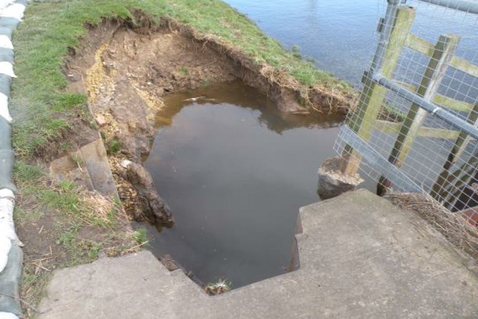
7.3 Incident 478
Dam type: earthfill embankment.
Reservoir legal status: statutory (large raised reservoir).
Dam height: 9m.
Incident type: other.
Incident severity: level 3.
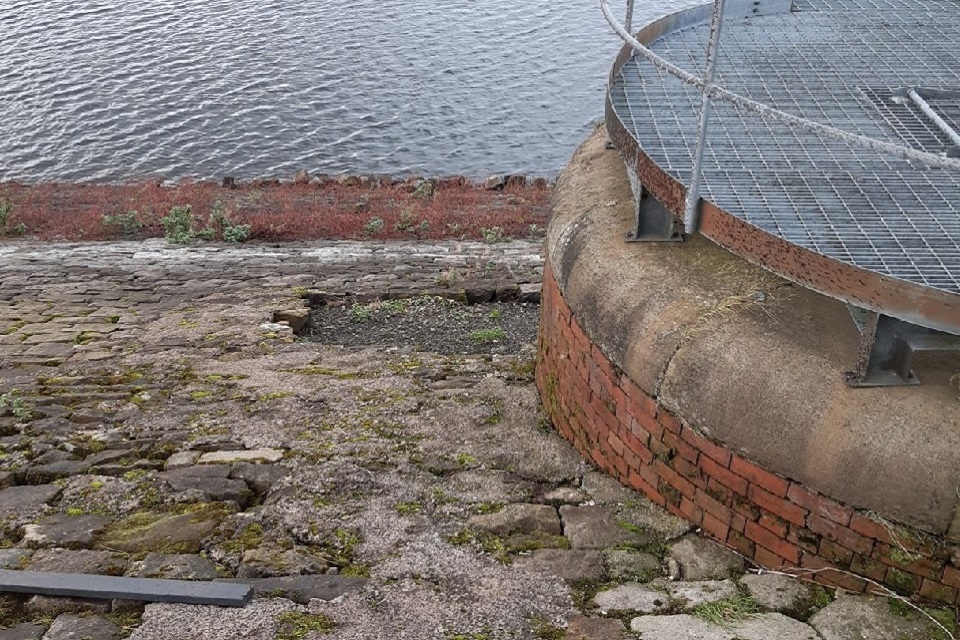
Routine surveillance identified damage to a draw-off valve due to vandalism. At this reservoir there is a 180mm diameter pipe at the base of an overflow shaft. A gate valve at the base of the shaft normally controls flows into the pipe.
Vandals removed masonry pitching blocks (stones) from the upstream face of the embankment. They threw them into the shaft through a gap between the overflow weir and the decking at the top of the shaft. The masonry struck the valve body and separated the valve from the pipe. This led to an uncontrolled release of water from the reservoir. The size of the pipe controlled the rate of flow and no damage to the dam occurred.
The undertaker has drawn down the reservoir water level until they can make suitable repairs. They plan to repair the pipe and change the screen arrangement to prevent large items entering the shaft.
The photograph shows the area of the embankment with missing stone pitching blocks.
"
Lessons learned
This incident highlights that undertakers must protect equipment from unauthorised activities. In this case, the damage did not pose a significant threat to the safety of the dam. But under slightly different circumstances the consequences could have been significant.
Security of upstream controls on pipes through or under embankments should have specific risk reviews.
7.4 Incident 479
Dam type: earthfill embankment.
Reservoir legal status: statutory (large raised reservoir).
Dam height: 9m.
Incident type: downstream slip.
Incident severity: level 3.
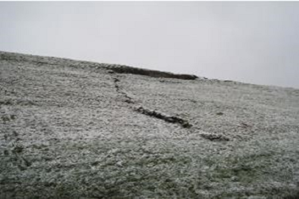
Following heavy rainfall, a shallow slope on the downstream shoulder of an embankment dam failed. The dam had a wide crest and was not thought to be at risk of failure. The undertakers drew down the reservoir as a precautionary measure.
The top of the erosion was just below the dam crest. It was 600mm deep over a length of 9m and 200mm deep over a further 8m. On one side there was a tear down the face of the dam with a 600mm deep crack. Towards the base of the slope there was an upward displacement of 200mm.
This photograph shows the erosion below the dam crest and the 600m deep crack down the downstream face.
"
Sluices controlled the water level and kept it more than 2m below top water level. The undertakers sealed the top crack with clay and covered the area of the slip with waterproof sheeting.
An inspecting engineer directed the undertaker to install piezometers (pore water pressure monitors), inclinometers (slope monitors) and movement monitoring pins.
Following the incident, the undertakers added a toe weight to the downstream face of the dam. They also added a pipe to the spillway at the mitre. The dam mitre is the connection between the dam and the side of the valley. This improves resilience against any future slope instability.
Lessons learned
The embankment contains 3 separate zones of construction material. These are silt, silty sand, and clay fill either side of the clay core. The position and elevation of the top of the core is not consistent over the dam length. Staff had identified a crack at the area of the slip in the previous year. The operator had sealed the crack with clay to reduce water ingress. The downstream face of the dam is relatively steep (1V:2H). It is susceptible to mass instability under extreme direct rainfall.
Due to climate change, the resilience of dams to direct rainfall is becoming more critical. Similar incidents are likely to occur at other sites. There are many relevant risk factors which include:
- reservoir operation
- dam crest width
- freeboard (height between the water and the dam crest)
- downstream slope
- geotechnical characteristics of the material of the downstream shoulder
When risks are high, monitoring equipment on the downstream face can be useful. It can provide early warning of progressive movement.
In some cases, the risks may warrant extra measures, such as changing reservoir operation. This could involve physical intervention, for example improving stability by adding toe weights and/or sub-surface drainage.
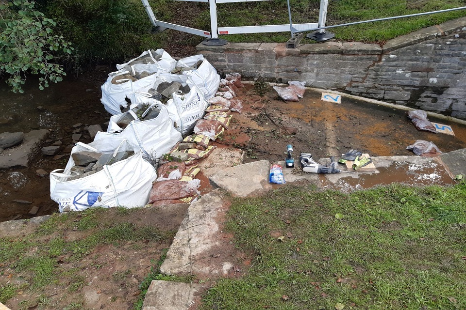
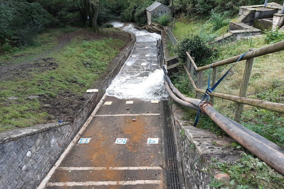
7.5 Incident 480
Dam type: earthfill embankment.
Reservoir legal status: statutory (large raised reservoir).
Dam height: 7m.
Incident type: spillway damage.
Incident severity: level 3.
This incident occurred at an impounding reservoir. It was undergoing temporary repairs to fill voids beneath the spillway chute. The works were in progress when the spillway started to operate during a period of heavy rain. There was risk of further erosion damage to the embankment fill under the chute. The dam could have failed with enough volume and duration of flow.
Urgent works mitigated the risk. The undertakers placed sandbags on the spillway crest. These were later topped up with 1-tonne aggregate bags. The undertakers placed sandbags on the chute to direct residual flow away from damaged areas.
This photograph shows how the spillway chute was isolated by adding sandbags to stop any water overflowing.
"
A bypass valve reduced the reservoir water level and two 6-inch pumps helped to move the flow away from the damage. The pumps arrived on site within 6 hours of the start of the incident.
This photograph shows the flow from the pumps and by-pass pipe.
"
Following the spillway repairs, the operators modified the operation of the reservoir. They reduced the normal operating water level, which reduces the frequency of spill events. This will remain in place until permanent repairs to the spillway are complete.
Lessons learned
Before work started on the temporary repairs the qualified civil engineer had given instructions on how to do it. Investigations found that these instructions were not followed.
There had also been interference by third parties (a hydropower operator and an angling club) during planning. This meant that before the work started the freeboard was lower than agreed.
The incident highlights the importance of:
- following professional advice when repairing safety-critical structures - all parties must agree to any changes in the planning of the works
- having contractual arrangements with pump suppliers before work starts
- the value of testing emergency plans