Guidance for preparing plans for HM Land Registry applications
Updated 13 October 2025
Applies to England and Wales

© Crown copyright 2025
This publication is licensed under the terms of the Open Government Licence v3.0 except where otherwise stated. To view this licence, visit nationalarchives.gov.uk/doc/open-government-licence/version/3 or write to the Information Policy Team, The National Archives, Kew, London TW9 4DU, or email: psi@nationalarchives.gov.uk.
Where we have identified any third party copyright information you will need to obtain permission from the copyright holders concerned.
This publication is available at https://www.gov.uk/government/publications/preparing-plans-for-land-registry-applications/guidance-for-preparing-plans-for-land-registry-applications
Please note that HM Land Registry’s practice guides are aimed primarily at solicitors and other conveyancers. They often deal with complex matters and use legal terms.
To view the update history for this practice guide, please see practice guide 40, supplement 2: update history.
1. Introduction
Customers tell us that preparing plans for registration purposes is not an easy task and we accept that it can sometimes be a tricky process, particularly when dealing with unregistered properties that have not changed hands for many years. However, deed plans are an essential element of buying and selling land.
The title plan and register cannot describe the land in a title any more accurately than the pre-registration deeds allow. The pre-registration deeds can play a crucial role in resolving any future issues or questions regarding the extent of the land in a registered title; good quality deed plans are a key aspect of this.
Any plan that needs to be lodged with an application for registration or for a search must be such that the land concerned can be identified clearly on the Ordnance Survey map.
HM Land Registry will use the guidelines set out in Plans for transfers/leases of part of a registered estate to consider a plan submitted as part of an application in form OS2 (search of part), as well as the prospective application the search seeks to protect.
To ensure the plan meets this standard, it should comply with the guidelines in Guidelines for preparing plans for HM Land Registry applications. This is not to say that a failure to comply with one or more of the guidelines will always prevent an application from proceeding. It will not where HM Land Registry is confident that the land can still be identified on the Ordnance Survey map. If the land cannot be clearly identified on the Ordnance Survey map, it may mean that the application is rejected, subject to a requisition or cancelled some time afterwards.
This supplement contains 2 tables: Table 1 provides guidelines for preparing plans for lodging with HM Land Registry applications with examples of plans that meet all the criteria. Table 2 lists some of the reasons why a plan would not meet the criteria with examples of deficient plans.
2. Why good quality plans are important
As stated above, the pre-registration deeds and their plans could play a crucial part in resolving any future boundary issues or questions regarding the extent of the land in a registered title. Plans that fulfill the guidelines set out in Table 1 below will:
- give buyers a clear understanding of what they have bought
- provide a sound basis should problems arise at a future date
- ensure applications lodged with HM Land Registry will be processed more efficiently and effectively
- lead to HM Land Registry rejecting fewer applications
It is vital that HM Land Registry staff can identify the location and accurate extent of the land in any search or deed inducing registration, and can do so in relation to the Ordnance Survey map. In most cases the best way to achieve this is to provide a plan showing the extent of the land and surrounding features and roads together with any rights that go with the land or to which it has been made subject. There are a few situations where just a verbal description will be sufficient and those situations are covered later. See Use of verbal descriptions.
3. Plans for specific application types or situations
The guidelines for a plan, even for an unusual application for registration, are fundamentally the same as for any other applications but with variations. The same guidelines apply to plans lodged with searches.
Subject to our advisory policy, we are always prepared to offer advice on the preparation of plans for a specific application.
4. Plans for first registrations
A first registration is, as the name suggests, the application that puts land on the register for the first time. For that reason an application for first registration must be accompanied by sufficient details for the land to be clearly identified on the Ordnance Survey map and in most cases a plan will be necessary. Occasionally a verbal description may be adequate, for example, in the case of a house with a clear postal description which is shown on the Ordnance Survey map with well established, fully defined boundary features. A verbal description without a plan is inadequate if there is any uncertainty about the land included, for example, where there are open side passageways, open plan frontages, undefined rear gardens or separate garage/buildings. See Use of verbal descriptions.
In circumstances where the plan to the deed inducing registration is not sufficient to allow clear identification of the land, we may ask for an additional plan(s) to be substituted or the existing plan amended. Any substituted or amended plan will need to be signed by the parties.
5. Plans for transfers/leases of part of a registered estate
Usually, transfers and leases of part will need to be accompanied by a plan showing the land being transferred or leased.
Where an approved estate plan exists, any plan used in the transfer or lease must be based on the current approved version of the estate plan. A verbal description by reference to plot numbers on the approved estate plan or the postal address is not acceptable.
See also practice guide 41: developing estates - registration services and its supplements. In other situations it may be possible to describe the land in a transfer or lease verbally but only where the extent of the land transferred or leased is already clearly defined on the seller’s/landlord’s title plan. See Use of verbal descriptions.
If the land transferred or leased does not have a clearly defined identifier on the seller’s/landlord’s title plan, for example, a colour reference or edging, a plan must be prepared for the transfer or lease.
The seller/landlord must sign the plan to the transfer or lease. When there are multiple plans in the transfer or lease, all of them must be signed including those situations where the plans relate to multiple dispositions in the deed (such as, extent, easement and/or the extent of any retained land). Where the seller/landlord is a company, the plan(s) should be signed by officers of the company with authority to sign on behalf of the company. The officers of the company whose signatures appear in the form of execution at the end of the transfer or lease can be taken to have the necessary authority.
The plan lodged must allow HM Land Registry to clearly identify the land on the Ordnance Survey map and should comply with the Guidelines for preparing plans for HM Land Registry applications. If the land cannot be clearly identified on the Ordnance Survey map, it may mean that the application is rejected on delivery or cancelled some time afterwards.
See practice guide 49: return and rejection of applications for registration.
6. Plans for unusual extents of land
HM Land Registry increasingly receives applications to register airspace, roof-space, tunnels and so on. Registrations of strata, either airspace or subsoil, can be freehold or leasehold and may be registrations in their own right or form part of the registration of another structure, typically commercial premises such as an office block, an industrial unit or a unit within a shopping complex. Depending upon their position, advertising hoardings may also comprise an unusual extent.
As with any application, it is important that we have a clear understanding of what it is that you want us to register. Invariably a plan will be required in these types of application. Like other types of application, we will need to know where the land falls in relation to existing ground surface detail so that we can identify the land on the Ordnance Survey map. In addition to this we need to know what depth or height is specifically included or excluded from your application. Where there is uncertainty we will ask you for clarification. The register and title plan will reflect the description contained in the deed regarding specified inclusions or exclusions.
Ordnance Survey datum, which is a national reference for heights, can be used to define height to fine tolerances. More information on OS Datum can be obtained direct from Ordnance Survey.
Guidance notes for preparing plans for floor levels, flats and maisonettes are included in Table 2.
7. Use of verbal descriptions
In examples 1 and 2 below, the properties shown would not be capable of registration by verbal description only as there would be uncertainty about the land sought to be registered.
Example 1
Example 1 shows properties with open plan frontages - the divisions between each would be impossible to describe unambiguously.
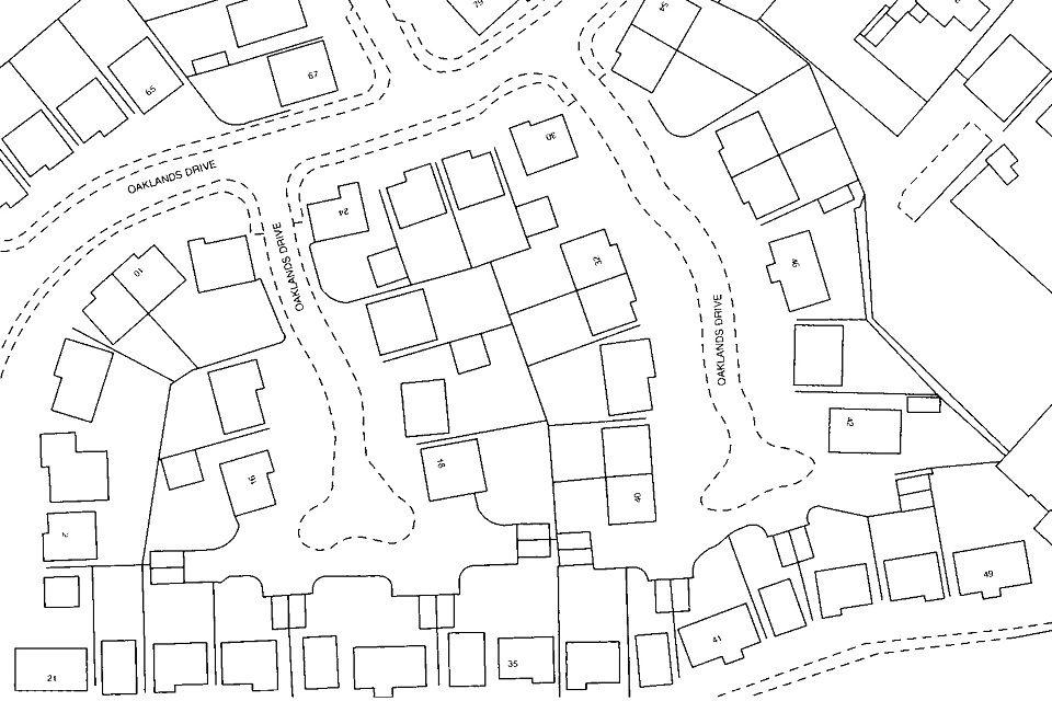
Example 1
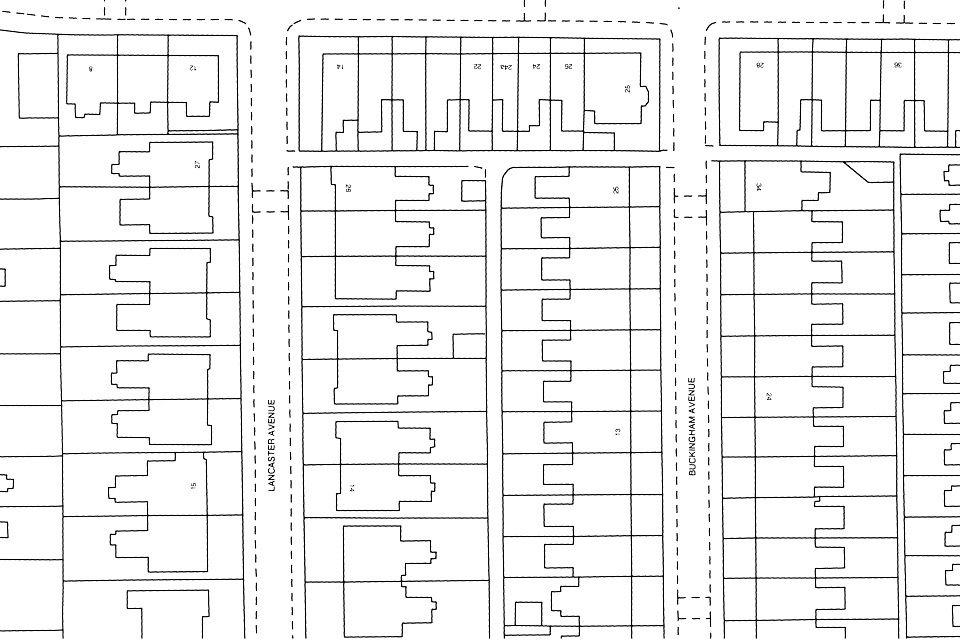
Example 2
Example 2 shows an older development where properties may also include areas of land such as access ways and outbuildings that make a verbal description impossible to determine.

Example 2
Example 3
In example 3 below, the majority of properties are fully defined by Ordnance Survey detail and therefore may be capable of being accepted for first registration based on a postal address.
Example 3
Example 4
Example 4 below is an extract from a seller’s title plan and shows how parts can be described verbally in a transfer/lease by reference to the title plan references, for example, ‘a transfer of the land comprising the part edged and numbered 3 in blue’. This would not be applicable if only part of the reference was being transferred or leased.
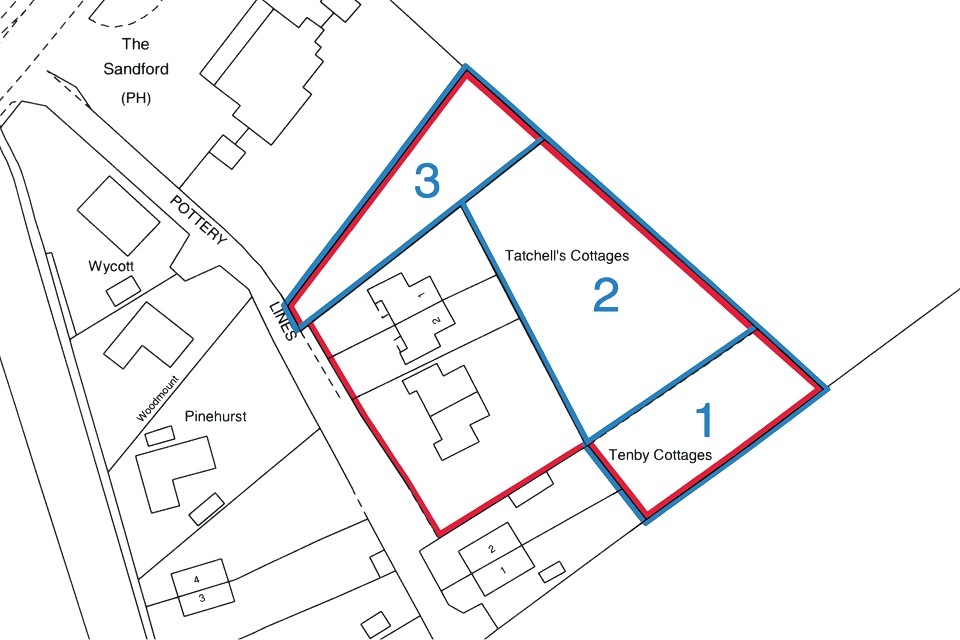
Example 4
8. Completion of the title plan as an alternative to raising requisitions
In appropriate circumstances, as an alternative to raising requisitions, we may prepare the title plan and issue a letter informing the applicant that the extent is different from the deeds and explain why. Examples of situations where this may happen are where part of the land in the application:
- clearly falls outside the occupied extent as shown on the latest Ordnance Survey map and therefore appears to be occupied by another owner
- is already registered under another ownership
- is not comprised in the seller’s/landlord’s title
Applicants may of course respond to the observations made in these letters.
9. Guidelines for preparing plans for HM Land Registry applications
HM Land Registry staff must have a clear understanding of the extent of the land and easements you are applying to search against, register or enquire about. The only exception to this is where the plan to an old deed is being used to indicate the land in an application for first registration. In circumstances where the deed plan is not sufficient to allow precise identification of the land, we may ask for an additional plan to be lodged.
When a plan forms part of a document dealing with part of the land in a registered title the plan must be signed by the disponor (transferor) or applicant, as appropriate, to comply with rule 213 of the Land Registration Rules 2003. We will accept a conveyancer signing on their behalf and you should endorse the signature to that effect when doing so.
This section of the guide offers some basic advice that you can apply to the majority of your dealings with HM Land Registry.
Any application for registration must contain a full description of the land to be registered. All of the following details should be included wherever possible:
- postal number or house name
- floor level, if applicable
- road name
- locality
- town
- administrative area
- postcode
Table 1 below shows the general guidelines for plans that you might be considering lodging with us, whether they are for search purposes or for substantive applications and whether they relate to urban or rural land. You might find it helpful to print Table 1 and use it as a checklist. Example 5 below shows a deed plan meeting all the guidelines.
When drawing up a deed it is important to ensure that the plan and description of the property are accurate, relate to the current state of the property and do not contradict each other. Simply carrying forward an earlier description may be misleading, particularly if a part of the land has been sold off.
It is important that the property is clearly defined on the plan by way of suitable reference such as colouring, edging, hatching or stippling and that the extent will be clearly visible, particularly when lodged electronically. It is also important to check whether any beneficial easements referred to are still exercisable. It is not necessary to provide an area measurement for the land.
Other applications, for example those relating to floors levels, flats, maisonettes and applications involving small areas of land will probably need to be treated slightly differently. Guidelines for this type of application are set out in Table 2 below and are additional to the guidelines set out in Table 1. Example 6 shows a floor level plan meeting all the guidelines.
Scale can be an important aspect in defining the extent of the land. Table 1 shows preferred scales for rural and urban properties; larger scales are acceptable but will not result in a larger scale title plan. Any plan attached to a certified copy of an original deed must be identical to the original in all respects.
9.1 The base plan
In the majority of instances the most commonly acceptable base plan for use in a deed is Ordnance Survey mapping or a copy of an approved estate layout plan. However, almost any plan that is drawn accurately to scale and follows the guidelines referred to in Table 1 should be satisfactory for use in a deed. Hand drawn sketches must not be used.
9.2 How to obtain mapping from Ordnance Survey
We acknowledge that it can sometimes be tricky to provide a good quality plan for registration purposes but to do so could result in improved speed of service when an application is lodged for registration. It could also be of benefit for the buyer if it provides the most recent survey detail of the property. HM Land Registry cannot supply extracts of Ordnance Survey map data it holds, either generally or for conveyancing purposes. Maps of a house or property for planning permission and/or submission to HM Land Registry are not available directly from Ordnance Survey or HM Land Registry. Please visit the Ordnance Survey website to find your nearest Ordnance Survey partner selling large scale maps for this purpose.
9.3 Using existing plans
We often receive applications where the plan used to identify and define the land was originally prepared for a different use, for example, plans drawn for architectural or engineering purposes. These often look impressive but, as they were prepared for a specific purpose other than to show the extent of land sold, they rarely conform to the guidelines in Table 1. Architectural or engineering plans concentrate on their primary purpose rather than seek specifically to provide a reliable and accurate depiction of title to land or of extent. A plan originally drawn as a location plan or road map will probably be at a scale that is too small to show the extent accurately.
Providing such plans follow the guidelines in this supplement and the extent of the land and easements is clear and unambiguous, the application can be processed. However, this is not always the case and plans that are in any way ambiguous are rejected.
9.4 Reference to old deed plans
Mainly with first registrations, the deed inducing registration often refers back to plans contained in earlier deeds in the chain of title. Providing we can relate the extent to the current Ordnance Survey map and the extent of the land in the deed is not in doubt, we will complete the registration on the evidence supplied. When referring back to older deeds in this way you should pay particular attention to any areas that have been previously sold off and whether any beneficial easements referred to in the property description are still exercisable. In circumstances where the deed plan is not sufficient to allow clear identification of the land, we may ask for an additional plan to be lodged. The additional plan does not have to be signed by the parties and it will be treated as though it was attached to the original application.
9.5 Plans that have been reduced in scale
Where it is clear that the plan contained in a deed or copy deed is a reduced copy of the original, it is only acceptable provided either a bar scale has been used or:
- the plan contains a statement that it is a reduced copy
- the original scale has been deleted
- the actual scale has been calculated and shown on the face of the plan in place of the original scale
In all cases the reduced plan must be clear and unambiguous.
9.6 Plans based on an official copy of the title plan
Plans based on an official copy of the title plan will not normally be rejected providing:
- there are no manual alterations to the official copy that result in the extent being in doubt
- an electronic official copy has not been so distorted by the electronic transmission process, printing and any subsequent copying, that the extent is in doubt
9.7 Photocopied plans
It is often the case that plans contained in deeds are photocopies of photocopies. Each time a plan is copied the accuracy and clarity is lost. A plan that already has edgings or colour on it before it is copied invariably suffers the most from this treatment. It follows that care must be taken when using photocopied plans to ensure that the extent of the land is clearly shown and that the plan has not been distorted in the copying process.
The plans in MapSearch are subject to Crown and Ordnance Survey (OS) copyright and database rights. Use of these plans is subject to OS conditions and it is the responsibility of the person using the plans to ensure that they are compliant with those conditions or have the appropriate licence from OS.
9.8 Plans printed from PDF
HM Land Registry is increasingly receiving plans lodged with applications that are not to the stated scale. We suspect that plans are being accurately produced and sent as a PDF to conveyancers. When they are printed from the PDF they are often inadvertently reduced to fit the paper size and are therefore no longer to the stated scale.
Software settings can be adjusted to print the plan without a reduction in size.
When printing PDF files, ‘Page scaling’ on the ‘Print’ menu can default to the ‘Shrink to printable area’ option (or a similar option, depending on your software). The ‘Preview’ panel will show the reduction in size expressed as a percentage.
To print without a size reduction, ensure that any ‘Scaling’ option is set to produce a print at 100 per cent of its original size. Any ‘Fit to page’ or ‘Shrink to printable area’ option should be deselected. The size of the paper may need to be changed.
To change the paper size, select the ‘Properties’ button, select the ‘Paper/Quality’ tab and then select the size of paper required from the appropriate ‘Paper options’ drop-down menu.
Changes made to the scaling options will subsequently default to the original settings and will need to be reapplied.
Table 1: general guidance
| The basic plan | Check |
|---|---|
| - has been drawn accurately to a stated scale – preferred scales are: (a) 1:1250 – 1:500 for urban properties (b) 1:2500 for rural properties (fields and farms etc) | |
| - shows its orientation (for example, a north point) | |
| - shows sufficient detail to be identified on the Ordnance Survey map of the surrounding roads and other features immediately outside the external boundaries of the site to enable the position and extent of the land, and/or proposed development, which is the subject of the application or search to be identified on the Ordnance Survey map and/or the lessor’s or vendor’s title plan | |
| - clarifies its general location by showing roads, road junctions or other landmarks | |
| - is based on a scale of metric measurement | |
| - ideally, is not marked as “for identification only” or similar wording | |
| - is not endorsed “Do not scale from this drawing” or any similar phrase, or includes a statement of disclaimer intended to comply with the Property Misdescriptions Act 1991 | |
| - includes a bar scale |
| Defining the property or land subject of your application – the plan shows: | Check |
|---|---|
| - the whole of the property including any garage, parking space, bin store or garden ground. | |
| - buildings in their correct (or intended) position. | |
| - access drives or pathways if they form part of property boundaries. | |
| - undefined boundaries accurately and where necessary, by reference to measurements. | |
| - measurements that correspond, so far as possible, to scaled measurements. | |
| - measurements in metres to 2 decimal places. | |
| - land and property clearly (for example by edging, colouring, stippling or hatching) - the edging/colouring must not obscure any other detail. | |
| - all colours referred to in the deed, with their extents clearly defined. |
| Floor levels, flats, maisonettes and small areas of land - the deed plan: | Check |
|---|---|
| - shows where the property falls in relation to the external footprint of the building and/or in relation to surrounding detail on the Ordnance Survey map. | |
| - shows the extent at each floor level, if necessary by using separate plans. | |
| - for subsoil or airspace, shows the levels between which the land falls or relates the land to Ordnance Survey Datum (mean sea level). | |
| - identifies different floor levels included (where appropriate). | |
| - shows intricate boundaries such as the internal divisions in a building, consider showing on a separate plan at a larger scale such as 1:200. | |
| - shows separate parts by suitable plan markings (house, garage, parking space, bin store etc) | |
| - must agree with the verbal description contained in the deed. | |
| - correctly shows all markings referred to in the deed. | |
| NOTE: Plans that do not bear either a scale or a north point, but are well drawn and show a clearly defined extent that can be precisely related to the Ordnance Survey map are acceptable. |
Example 5: deed plans that meets all the guidelines
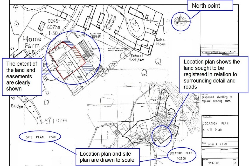
Example 5
This is an example of a well drawn and presented deed plan that does its job effectively by using a recognisable map base to which the colours have been added rather than being a copy of an already coloured copy. The attributes shown annotated on the plan, other than measurements, are listed in the general guidelines in Table 1.
Example 6: floor level plan that meets all the guidelines
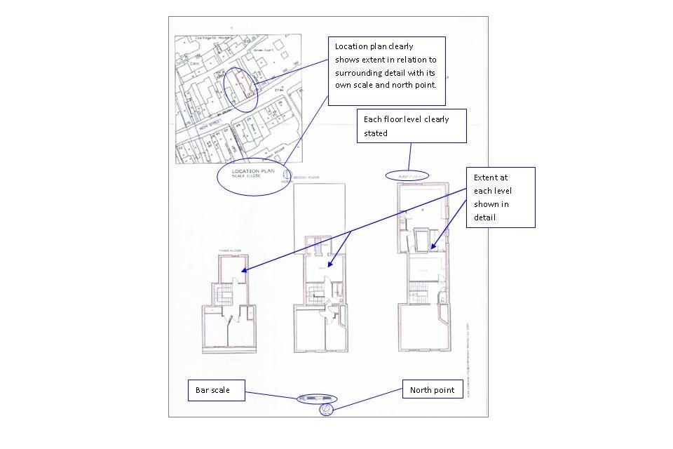
Example 6
Explanatory note
This is an example of a well drawn lease plan. The location plan has a recognisable map base and the north point allows HM Land Registry to be certain of the location of the land in the context of surrounding detail. Supplementing the scale with a bar scale allows us to accept the plan even if it has been reduced in copying. The extent at each level is edged in red and its relationship with the footprint of the building is clear, allowing HM Land Registry and the tenant to understand precisely what has been leased.
Table 2: plan defects that may result in the application being rejected
There is a great variation in the quality of deed plans that are contained in title deeds so this section contains some typical examples of deed plans that are not capable of supporting registration.
Where the deed plan is not sufficient to allow clear identification of the land we may ask for an additional plan to be lodged. The plan is not evidence of the applicant’s title. The additional plan will need to be signed by the applicant if the application relates to registered land. We will treat the plan as though it was attached to the original application.
| The following, which covers most eventualities is, however, not an exhaustive list of points that may lead to the application being rejected: |
|---|
| Where the deed refers to a plan but it is not attached. |
| Plans that have not been signed by the seller/landlord. |
| Plans where the scale used makes the extent of the land or easements uncertain. |
| Plans that have been reduced from their original scale but that still bear the original scale endorsement (unless a bar scale has been used). |
| Plans marked as “for identification only” or similar wording may be rejected. Unless the plan can be accurately related to the OS map and any description in the deed is not at variance with either the OS map or the plan. |
| Plans where a colouring or marking referred to has been omitted from the plan |
| Plans where the extent of any easements is unclear. See example 7 |
| Plans where we cannot locate the land with any degree of confidence. See examples 7 and 8 |
| Plans that cannot be orientated to align with the Ordnance Survey Map. See examples 7 and 9 |
| Plans that have not been drawn to scale. See examples 7 and 9. |
| Plans with edgings of a thickness that obscures any other detail or that makes the extent any way ambiguous. See example 8 |
| Plans where the extent is undefined or is unclear. See example 9 |
| Hand drawn sketches. See example 9 |
Example 7: detail cannot be related to the OS Map - application will be rejected
Example 7
Explanatory note
The hatched area is the subject of the application for registration with a right of way over the shaded area. Although the deed contains both a location plan and a plan to a larger scale, it is impossible to identify with any degree of confidence where the land on the deed plan falls in relation to the Ordnance Survey map detail. It is also impossible to define the extent of the land to be registered and the easement that runs with it. This application would be rejected.
The plan is deficient in many respects and would benefit from:
- a north point, as this would allow us to orientate the deed plan with the Ordnance Survey map
- a scale, which would allow us to assess the size of the hatched and shaded areas
- more detail on the deed plan, which would allow us to see its position in the wider context of the location plan and the Ordnance Survey map
- being based on the Ordnance Survey map as would provide a higher degree of confidence
Example 8: extent not clearly defined - application will be rejected
Example 8
Explanatory note
In this example, the plan has a recognisable map base so it is easy for us to orientate it to our records but it is impossible to determine the extent with any degree of confidence. It appears as if the intention might be for 2 of the boundaries to follow the Ordnance Survey detail but even so the edging overlaps it significantly in many places. The remaining 2 boundaries are completely undefined and the accuracy of the edging, even where Ordnance Survey detail exists, casts doubt over the whole extent. It is also unclear as to the intention in respect of the access driveway and possible easements. This application would be rejected.
The plan would benefit from:
- plotted lines showing the precise extent intended to be registered
- a scale
- measurements, which could help to define the extent
- a thinner, more precise edging
Although there is no north point, because the plan has a recognisable map base it is easy to orientate it in relation to our records.
A more carefully drawn edging would give more confidence in the plan as a whole, both for HM Land Registry and for the buyer.
Example 9: poor quality or re-use of old deed plans - application will be rejected

Example 9
Explanatory note
In this example, the conveyance plan has been hand drawn and is not to any stated scale. There is a small amount of surrounding detail but the poor verbal description and the lack of north point does not allow the land to be easily reconciled with the Ordnance Survey map. As for defining the land, there is particular doubt over the extent conveyed in those areas where the red edging lies close to but away from the underlying plan detail.
If this was the only plan available on first registration we may ask for an additional plan to be lodged. The additional plan would need to be signed by the applicant and we will treat the plan as though it was attached to the original application. The new plan would allow us to identify the extent and location of the land more precisely.
10. E-lodgement of plans
Plans that have been prepared following the requirements in Guidelines for preparing plans for HM Land Registry applications may be scanned as part of a deed and submitted electronically when uploading deeds or documents to your application.
The plan needs to be of the same acceptable standard as the original. The plan must show sufficient map detail of the extent, surrounding roads and other features immediately outside the external boundaries of the site to enable the position and extent of the land and any easements, to be accurately related to the Ordnance Survey map and the parent title plan. A copy of the plan will form part of any official copy of the document.
Recommendations for producing a clear, high quality image for scanned plans:
- Scan the plan at its original size
- Scan the plan in full colour
- Use a resolution of not less than 200dpi and not more than 600dpi
A plan depicting a single extent must not comprise more than 2 scanned pages and each scanned page must be no larger than A3. Any plan submitted in parts must include sufficient detail to enable the relationship between the parts to be clear, and to enable any printed copy to be readily reconstructed into a single page plan. Where the extent straddles both sections of the scanned plan, include an additional scanned copy of the plan, if necessary at a reduced scale, showing the full extent on a single page.
Note: Where a deed comprises multiple plans depicting (for example) numerous floor levels within a building, it is acceptable to scan these as a series of separate plans. If a single floor level plan is larger than A3, the general guidance above applies – a maximum of 2 plans no larger than A3 will be accepted.
11. Things to remember
To avoid requisitions, before submitting your application to us:
- ensure that any colouring, edging or other markings mentioned in the deed are shown clearly on the plan
- ensure that any plan to the deed or application form which deals with the extent of the property, easements, or retained land is signed
- ensure that any plan to a form DS3 is signed by or on behalf of the lender to signify their agreement as to the extent to be discharged
- if the plan is printed from a PDF image, please ensure it has not been inadvertently reduced to fit the paper size. You can amend your printer settings to alleviate this issue by following the instructions in section 9.8 of practice guide 40: supplement 2
The plan supplied in support of an official search and subsequent deed for registration must:
- show clearly and precisely, by suitable colouring or edging, the precise extent of the land to be searched
- be drawn to a stated scale and show the scale to which it is drawn
- show a north point
- not be marked “for identification purposes only”
- show sufficient detail of the surrounding roads and other features to enable the position and extent of the land to be identified on the Ordnance Survey map and /or the parent title plan
The plan should make clear on which floor level(s) (if any) the land lies by colouring the precise extent of each level and ensuring the extent is clear in relation to existing detail on the title plan and external boundaries or outline of the building of which it forms a part.
We only provide factual information and impartial advice about our procedures. Read more about the advice we give.