
Lower Mersey abstraction licensing strategy
Updated 10 July 2026
Applies to England

© Crown copyright 2026
This publication is licensed under the terms of the Open Government Licence v3.0 except where otherwise stated. To view this licence, visit nationalarchives.gov.uk/doc/open-government-licence/version/3 or write to the Information Policy Team, The National Archives, Kew, London TW9 4DU, or email: psi@nationalarchives.gov.uk.
Where we have identified any third party copyright information you will need to obtain permission from the copyright holders concerned.
This publication is available at https://www.gov.uk/government/publications/lower-mersey-and-alt-abstraction-licensing-strategy/lower-mersey-abstraction-licensing-strategy
1. About the licensing strategy
This strategy sets out our approach to managing new and existing abstractions and impoundments within the Lower Mersey catchment in the North West river basin district.
This strategy replaces the previously published Lower Mersey and Alt strategy. The strategy for the River Alt catchment is available in the Alt Crossens abstraction licensing strategy.
Our approach ensures that we:
- meet river basin management plan objectives for water resources activities
- avoid deterioration within this catchment
These requirements are set out by the Water Environment (Water Framework Directive) (England and Wales) Regulations 2017 (referred to as the Water Framework Directive 2017). We apply this approach to the water body in which the abstraction or impoundment is located.
It also applies to:
- all downstream surface water bodies that may be affected by any reduction in abstraction related flow
- adjacent groundwater bodies affected by any reduction in groundwater level
The strategy also sets out local approaches to the sustainable management of water resources in collaboration with partners.
Our guidance on managing water abstraction gives the technical explanation, legal and policy requirements behind the abstraction licensing strategies (ALS).
Please see our guidance if you need to:
- check if you need a licence to abstract water
- check if you need a licence to impound water
- apply for an abstraction or impounding licence
We continuously update our assessment tools, because of this some details in this document, for example hands off flow (HoF) values, may be out of date. You can contact the Environment Agency for the latest data.
Collaborative and sustainable water management
Our long-term goal is to develop a stronger catchment focus for water resources. We are working with abstractors and catchment groups to:
- develop local solutions to existing pressures
- to prepare for the future
Catchment groups may include a variety of different partnership groups such as:
- abstractor groups
- local catchment partnerships
- priority catchment groups
- environmental groups
Regional water resources groups are taking forward strategic multi-sector regional plans which consider environmental needs for long term planning. We are working with these groups to improve the connection between regional planning and catchment scale planning and delivery. There is more information on regional planning in the National Framework for Water Resources.
This strategy is a tool to make informed decisions on the choices abstractors make about their use of water. We want this strategy to help abstractors plan their water use and become more resilient in the face of climate change.
2. Catchment overview
The Lower Mersey ALS catchment covers land drained by inland river systems feeding into the main body of the River Mersey, as well as the underlying groundwater systems. The area includes Liverpool, the Wirral peninsula, Runcorn, Ellesmere Port, St. Helens, Warrington, and parts of Wigan. Map 1 outlines the ALS area and its boundary.
2.1 Landscape and land use
The catchment is characterised by some large, urbanised areas within interspersed with more rural areas. The land of the Lower Mersey catchment is generally very low lying. The higher altitudes in the upper tributaries are all under 200m above ordinance datum (AOD). The River Mersey is linked to the heavily modified Manchester Ship Canal which is contained within the 45m contour. The flatness of the catchment means that Lower Mersey is tidal up to as far as Warrington.
2.2 Water resources
There are three main tributary catchments for this stretch of the River Mersey: Sankey Brook, Glaze Brook and the River Gowy.
Sankey Brook drains a heavily urbanised area that is dominated by St. Helens and the western part of Warrington.
Glaze Brook originates at the confluence of Pennington and Moss Brooks before eventually discharging into the Manchester Ship Canal southeast of Cadishead.
The River Gowy catchment originates at Bunbury, flowing west parallel to the Shropshire Union Canal before flowing north through mainly open land, eventually reaching the estuary at Ellesmere Port.
The geology of the Lower Mersey catchment is dominated by sandstones that are part of the Permio-Triassic Sandstone aquifer. The area covered by this ALS includes parts of the Manchester and East Cheshire, the Lower Mersey Basin, the Liverpool and Ormskirk and the Wirral and West Cheshire aquifers.
Water in the catchment is abstracted from surface and groundwater sources for a wide variety of uses, including agriculture (dairy and arable), industry and water supply. Industry ranges from brewing, to food processing, to chemicals, biotechnology and the automotive industry.
Water-based recreational activities in this catchment include angling and rowing.
2.3 Climate change
Climate change is likely to affect the quantity and seasonal availability of water resources within the catchment. The Environment Agency climate impacts tool provides a simple description of current and potential future challenges.
Map 1. Catchment overview of the Lower Mersey ALS
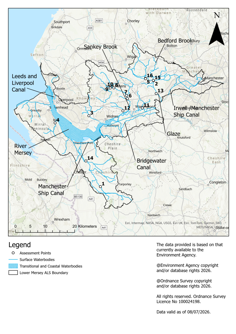
Map 1 shows the extent of the Lower Mersey catchment. The location of the 16 assessment points and major surface water bodies are also presented. The catchment extends from the urban fringes of Greater Manchester in the east, through Trafford and Salford, and westwards across Warrington, Widnes and Runcorn, before reaching the Mersey Estuary and coastal areas around Liverpool and Sefton. Key waterbodies include the River Mersey, River Irwell, River Bollin, River Tame, and The Manchester Ship Canal. These waterbodies generally flow from the more elevated inland areas in the east towards the lower-lying, highly urbanised and estuarine environments in the west.
3. Water resource availability in the Lower Mersey catchment
3.1 Surface water availability
The method for calculating the water resource availability is explained in managing water abstraction. Water availability is calculated at selected assessment points (APs). The maps show the water availability calculated at the AP; local water availability may differ.
There are 16 APs in the Lower Mersey ALS:
- AP01: Huxley Gauging station, on the upper stretch of the River Gowy by Lower Huxley Hall
- AP02: Moss Brook, prior to Pennington Brook, south of Leigh
- AP03: Ditton Brook at Halewood, prior to confluence with the River Mersey
- AP04: Dibbinsdale Brook, at Bromborough Pool prior to confluence with the River Mersey
- AP05: Westleigh Brook, downstream of Pennington Flash, Leigh
- AP06: Sankey Brook at Causey Bridges Gauging Station, Warrington
- AP07: Newton Brook downstream of Vulcan Village, prior to confluence with Sankey Brook
- AP08: Black Brook at Sankey Valley Park, St Helens
- AP09: Sutton Brook at Parr Stocks, prior to Sankey Brook
- AP10: Rainford Brook at Parr Stocks, prior to Sankey Brook
- AP11: Spittle Brook at Paddington, prior to River Mersey
- AP12: Whittle Brook, Great Sankey, prior to confluence with Sankey Brook
- AP13: Glaze Brook at Little Woolden Hall Gauging Station, upstream of Glazebrook
- AP14: Bridge Trafford Gauging Station, on the Lower stretch of the River Gowy, where Black Brook meets the Gowy
- AP15: Bedford Brook, prior to confluence with Black Brook, Leigh
- AP16: Westleigh Brook, Pennington, prior to Pennington Brook
3.2 Water resource availability colours and implications for licensing
The water resource availability is calculated and the colour assigned at four different flows:
- Q30 – the flow of a river which is exceeded on average for 30% of the time, therefore you would expect the river flow to be lower than Q30 on 256 days in an average year, that is, a higher flow
- Q50 – the flow of a river which is exceeded on average 50% of the time, therefore you would expect the river flow to be lower than Q50 on 183 days in an average year
- Q70 – the flow of a river which is exceeded on average for 70% of the time, therefore you would expect the river flow to be lower than Q70 on 110 days in an average year
- Q95 – the flow of a river which is exceeded on average for 95% of the time, therefore you would expect the river flow to be lower than Q95 on 18 days in an average year, that is, a low flow
We use the colours below to represent different surface water availability at these flows:
Water available for licensing
Green

There is more water than required to meet the needs of the environment.
New licences can be considered depending on local and downstream impacts.
Restricted water available for licensing
Yellow

Full licensed flows fall below the environmental flow indicators (EFI).
If all licensed water is abstracted there will not be enough water left for the needs of the environment. No new consumptive licences would be granted. It is likely we will be taking action to reduce full licensed risks. Water may be available if you can ‘buy’ (known as licence trading) the entitlement to abstract water from an existing licence holder.
Water not available for licensing
Red

Recent actual flows are below the EFI (or have been overridden by a downstream AP where flows are below the EFI).
This scenario highlights water bodies where flows are below the indicative flow requirement to help support a healthy ecology in our rivers. We will not grant further licences in these water bodies.
We are currently taking action in these water bodies. Water may be available if you can buy (known as licence trading) the amount equivalent to recently abstracted from an existing licence holder.
There may be water available for abstraction in discharge rich catchments. You need to contact the Environment Agency to find out more.
3.3 Water availability maps
The water availability colours for the Lower Mersey catchment are presented in maps 2 to 6.
Table 1. Summary of maps 2 to 6 water availability at each assessment point by flow category
| Assessment point | Assessment point name | Q30 | Q50 | Q70 | Q95 |
|---|---|---|---|---|---|
| AP01 | Huxley GS (Upper Mersey) | restricted water available | restricted water available | water not available | water not available |
| AP02 | Moss Brook | water available | water available | water available | water available |
| AP03 | Ditton Brook (ptc River Mersey) | water available | water available | water available | water available |
| AP04 | Dibbinsdale Brook ptc River Mersey | water available | water available | water available | water available |
| AP05 | Westleigh Brook | water available | water available | water available | water available |
| AP06 | Sankey Brook at Causey Bridge GS | water available | water available | water available | water available |
| AP07 | Newton Brook | water available | water available | water available | restricted water available |
| AP08 | Black Brook | water available | water available | water available | water available |
| AP09 | Sutton Brook | water available | water available | restricted water available | restricted water available |
| AP10 | Rainford Brook | water available | water available | water available | restricted water available |
| AP11 | Spittle Brook | water available | water available | water available | water available |
| AP12 | Whittle Brook | water available | water available | water available | water available |
| AP13 | Glaze Brook at Little Woolden Hall GS | water available | water available | water available | water available |
| AP14 | Bridge Trafford GS (Lower Gowy) | water available | restricted water available | restricted water available | water not available |
| AP15 | Bedford Brook | water available | water available | water available | water available |
| AP16 | Westleigh Brook | water available | water available | water available | water available |
Map 2. Water resource availability colours at Q30, Q50, Q70 and Q95 for the Lower Mersey ALS
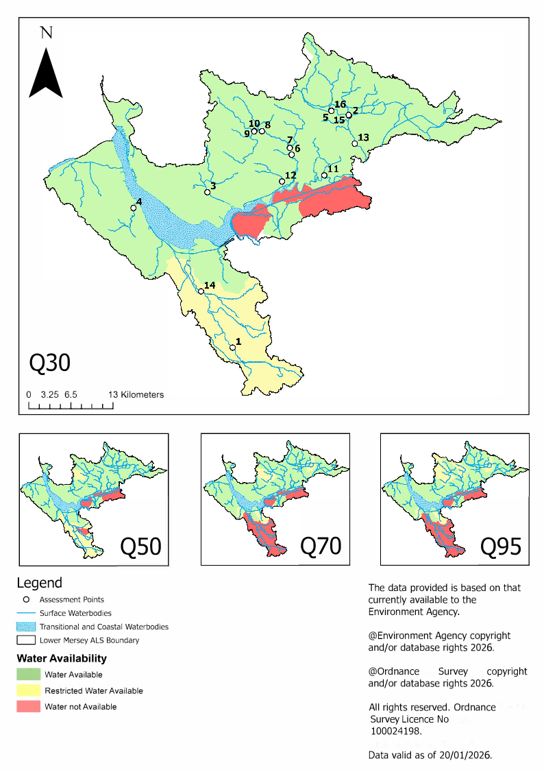
Map 2 shows the water availability across the Lower Mersey catchment at each flow category.
Map 3. Water resource availability colours at Q30 for the Lower Mersey ALS
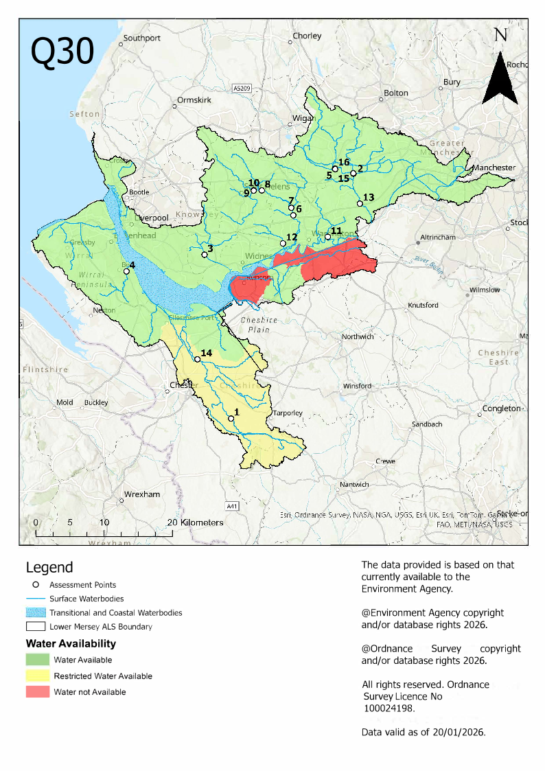
Map 3 shows the water availability across the Lower Mersey catchment at Q30.
Map 4. Water resource availability colours at Q50 for the Lower Mersey ALS
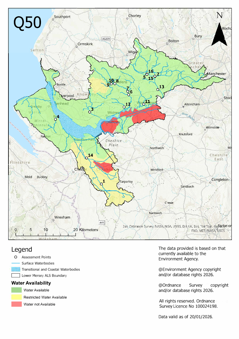
Map 4 shows the water resource availability colours at Q50 for the Lower Mersey catchment
Map 5. Water resource availability colours at Q70 for the Lower Mersey ALS
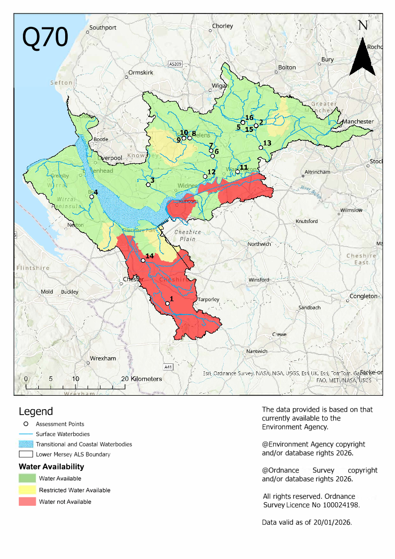
Map 5 shows the water resource availability colours at Q70 for the Lower Mersey catchment
Map 6. Water resource availability colours at Q95 for the Lower Mersey ALS
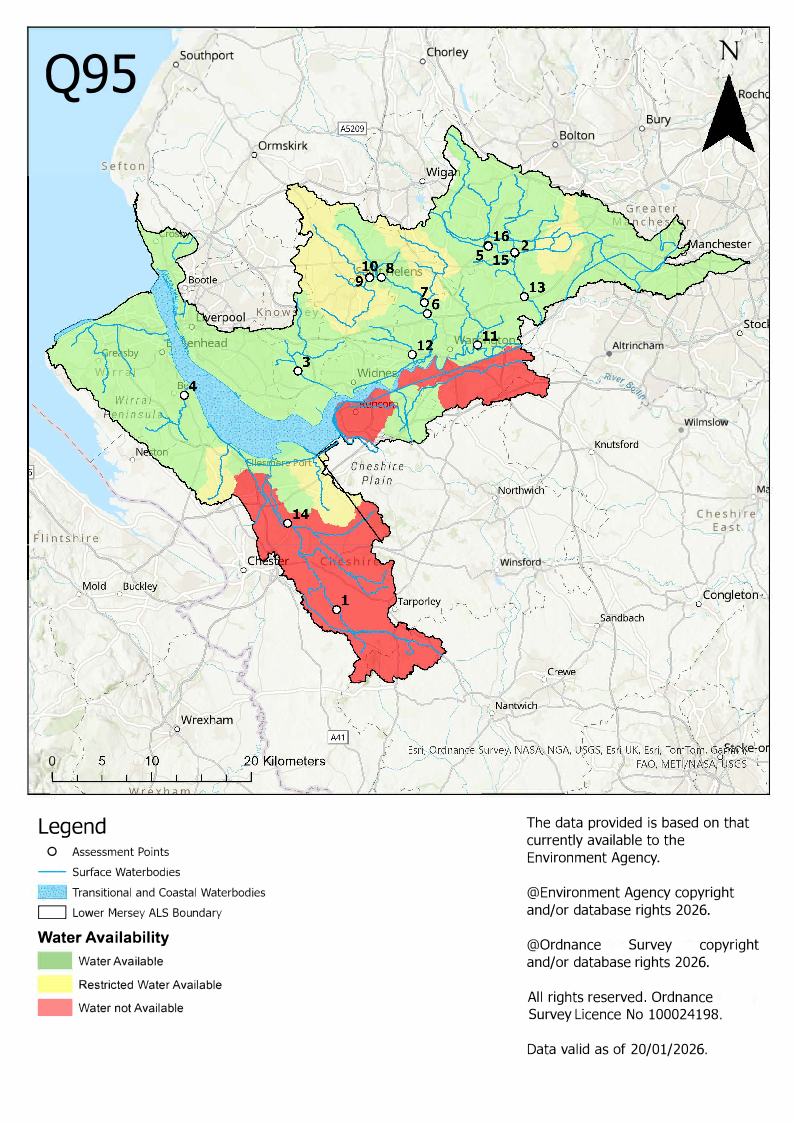
Map 6 shows the water resource availability colours at Q95 for the Lower Mersey catchment
3.4 Groundwater resource availability
Abstracting groundwater can impact on overlying surface water bodies and groundwater dependent ecosystems. This impact is measured at the surface water AP. We cannot grant new groundwater licences where abstraction is reducing flows to below the indicative flow requirement to help support a healthy ecology. This is based on Q95 flows.
We must also account for:
- the available resource in the aquifer
- the impact of abstraction on protected sites
- the risk of saline intrusion
Water availability for groundwater in this catchment is dealt with on a case-by-case basis. Contact the Greater Manchester, Merseyside and Cheshire Integrated Environmental Planning and Groundwater and Contaminated Land area teams for further information relating to groundwater abstraction.
3.5 Resource reliability
If you want to apply for a licence, it is worth considering the reliability of your abstraction.
By assessing the quantity of water available at different flows it is possible to see:
- when there is a surplus or deficit of water
- the associated reliability of an abstraction
This is an indication only. Actual reliability of a licence will be discussed when you apply.
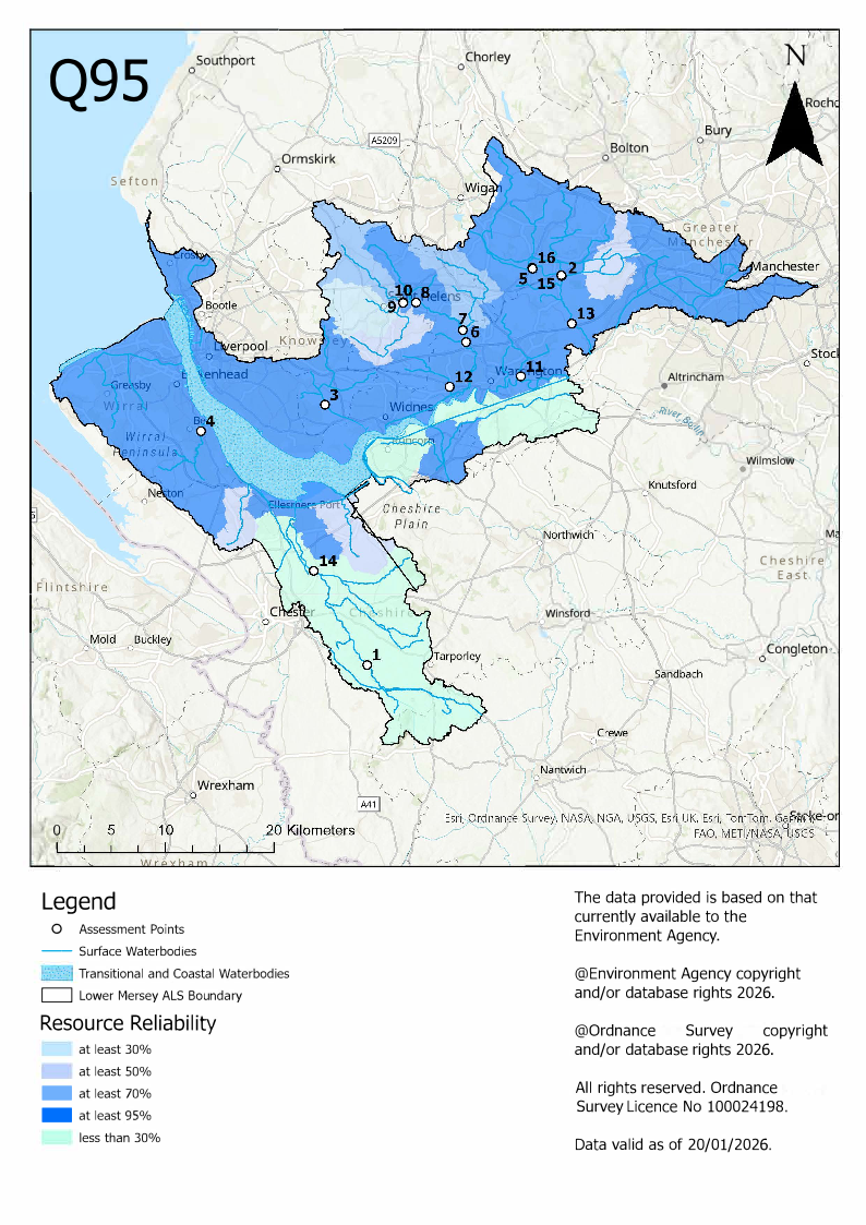
Map 7 gives an indication of the resource availability for consumptive abstraction in the Lower Mersey area expressed as a percentage of time. In this catchment:
- AP01: Consumptive abstraction is available less than 30% of the time
- AP02: Consumptive abstraction is available at least 50% of the time
- AP03: Consumptive abstraction is available at least 95% of the time
- AP04: Consumptive abstraction is available at least 95% of the time
- AP05: Consumptive abstraction is available at least 95% of the time
- AP06: Consumptive abstraction is available at least 95% of the time
- AP07: Consumptive abstraction is available at least 70% of the time
- AP08: Consumptive abstraction is available at least 95% of the time
- AP09: Consumptive abstraction is available at least 30% of the time
- AP10: Consumptive abstraction is available at least 70% of the time
- AP11: Consumptive abstraction is available at least 95% of the time
- AP12: Consumptive abstraction is available at least 95% of the time
- AP13: Consumptive abstraction is available at least 95% of the time
- AP14: Consumptive abstraction is available less than 30% of the time
- AP15: Consumptive abstraction is available at least 95% of the time
- AP16: Consumptive abstraction is available at least 95% of the time
Map 7. Water resource reliability of the Lower Mersey ALS expressed as a percentage of time available
3.6 Other considerations for resource availability and reliability
When we grant a licence, it does not mean that we guarantee a supply of water.
We may have to add constraints to licences such as ‘hands off flow’ (HoF) or ‘hands off level’ (HoL) conditions to protect the environment and the rights of other abstractors. These conditions specify, that if the flow or level in the river drops below what is needed to protect the environment, abstraction must reduce or stop. In dry years, restrictions are likely to apply more often, which will affect the reliability of supply.
Whilst this document may say that water is available for abstraction, this does not guarantee that all applications will be successful. This is because we must determine each application on its own merits, and local factors may mean we are either unable to grant a licence as applied for, or even at all.
New licences within an ALS are usually given a ‘common end date’ (CED), which allows them to be reviewed at the same time.
The next CED for this ALS is the 31 March 2028, and the subsequent one is the 31 March 2040.
3.7 Impoundments
Applications for impounding licences will be dealt with on a case-by-case basis and take into account the requirements of our obligations under the Conservation of Habitats and Species Regulations 2017 and Water Framework Directive 2017.
An impoundment is a dam, weir or other construction in an inland waterway that obstructs or impedes flow. Our assessment of an impounding licence application takes into consideration its potential impacts on the environment (such as fish migration), flood risk, downstream water users and flow modification. In line with current legislation, we do not time limit impounding licences.
You must have an impounding licence before you start to construct, alter, repair, or remove an impounding structure, even in an emergency. However, certain exemptions may apply and if we deem there is little or no impact on the environment and other water users, you may not need a licence.
Contact the Environment Agency if you intend to construct, alter, repair, or remove an impounding structure so that we may advise you whether a licence is required.
There is more information in our guidance on how to check if you need a licence to impound water.
4. How we manage water availability in the Lower Mersey ALS
4.1 Surface water
We assess surface water flows at each AP, which are significant points on a river, often where two major rivers join or at a gauging station. An AP can cover multiple surface water bodies.
Where groundwater abstractions directly impact on surface water flows, the impact is measured at the surface water AP.
The information for each AP gives an indication of:
- how much water is available for further abstraction
- the associated restrictions we may have to apply to new and varied abstraction licences from the main river
Depending on the nature of the catchment, tributaries to the main river may be subject to different restrictions and quantities. This may be assessed locally on a case-by-case basis.
Each HoF is linked to an AP and is dependent on the resource availability at that AP. In some cases, additional restrictions may apply to licences where there is a more critical resource availability downstream to protect the ecological requirements of the river and other water users. This has been considered in the figures given for each AP.
All abstraction licence applications are subject to an assessment. This takes account of any local and downstream issues and may be subject to further restrictions.
The following subsections provide information for each AP in the Lower Mersey ALS area. Each subsection shows the potential reliability of a new licence expressed as the number of days water may be available under this restriction during an average year. In cases where there is water available at all flows, we may apply a minimum residual flow (MRF) equal to 75% of Q99 flows in the water body to protect very low flows. We will decide this on a case-by-case basis.
4.2 Summary of licensing approach for the assessment points of the Lower Mersey ALS
1. AP01 Huxley GS (Upper Mersey)
| National Grid reference | SJ4963962443 |
| HoF restriction (Ml/d) | 37.3 |
| Number of days a year abstraction may be available | Contact Area |
| Approximate volume available at restriction | 15.2 |
| Gauging station at this AP | Yes |
2. AP02 Moss Brook
| National Grid reference | SJ6756998261 |
| HoF restriction (Ml/d) | 3.0 |
| Number of days a year abstraction may be available | 365 |
| Approximate volume available at restriction | 7.4 |
| Gauging station at this AP | Yes |
3. AP03 Ditton Brook (ptc River Mersey)
| National Grid reference | SJ4573986422 |
| HoF restriction (Ml/d) | 3.5 |
| Number of days a year abstraction may be available | 365 |
| Approximate volume available at restriction | 14.2 |
| Gauging station at this AP | Yes |
4. AP04 Dibbinsdale Brook (ptc River Mersey)
| National Grid reference | SJ3432283994 |
| HoF restriction (Ml/d) | 6.8 |
| Number of days a year abstraction may be available | 365 |
| Approximate volume available at restriction | 1.7 |
| Gauging station at this AP | Yes |
5. AP05 Westleigh Brook
| National Grid reference | SJ6488398951 |
| HoF restriction (Ml/d) | 6.8 |
| Number of days a year abstraction may be available | 365 |
| Approximate volume available at restriction | 1.2 |
| Gauging station at this AP | Yes |
6. AP06 Sankey Brook at Causey Bridge GS
| National Grid reference | SJ5873992209 |
|---|---|
| HoF restriction (Ml/d) | 35.8 |
| Number of days a year abstraction may be available | 365 |
| Approximate volume available at restriction | 35.3 |
| Gauging station at this AP | Yes |
7. AP07 Newton Brook
| National Grid reference | SJ5847093280 |
| HoF restriction (Ml/d) | 4.5 |
| Number of days a year abstraction may be available | Contact Area |
| Approximate volume available at restriction | 0.0 |
| Gauging station at this AP | Yes |
8. AP08 Black Brook
| National Grid reference | SJ5415995831 |
| HoF restriction (Ml/d) | 2.3 |
| Number of days a year abstraction may be available | 365 |
| Approximate volume available at restriction | 0.6 |
| Gauging station at this AP | Yes |
9. AP09 Sutton Brook
| National Grid reference | SJ5295495802 |
| HoF restriction (Ml/d) | 11.9 |
| Number of days a year abstraction may be available | 365 |
| Approximate volume available at restriction | 1.3 |
| Gauging station at this AP | Yes |
10. AP10 Rainford Brook
| National Grid reference | SJ5297295870 |
| HoF restriction (Ml/d) | 8.4 |
| Number of days a year abstraction may be available | Contact Area |
| Approximate volume available at restriction | 0.9 |
| Gauging station at this AP | Yes |
11. AP11 Spittle Brook
| National Grid reference | SJ6379689030 |
| HoF restriction (Ml/d) | 1.4 |
| Number of days a year abstraction may be available | 365 |
| Approximate volume available at restriction | 0.3 |
| Gauging station at this AP | Yes |
12. AP12 Whittle Brook
| National Grid reference | SJ5723488071 |
| HoF restriction (Ml/d) | 0.7 |
| Number of days a year abstraction may be available | 365 |
| Approximate volume available at restriction | 0.2 |
| Gauging station at this AP | Yes |
13. AP13 Glaze Brook at Little Woolden Hall GS
| National Grid reference | SJ6848893912 |
| HoF restriction (Ml/d) | 33.2 |
| Number of days a year abstraction may be available | 365 |
| Approximate volume available at restriction | 46.2 |
| Gauging station at this AP | Yes |
14. AP14 Bridge Trafford GS (Lower Gowy)
| National Grid reference | SJ4473871122 |
| HoF restriction (Ml/d) | 51.3 |
| Number of days a year abstraction may be available | Contact Area |
| Approximate volume available at restriction | 1.6 |
| Gauging station at this AP | Yes |
15. AP15 Bedford Brook
| National Grid reference | SJ6753098348 |
| HoF restriction (Ml/d) | 1.4 |
| Number of days a year abstraction may be available | 365 |
| Approximate volume available at restriction | 0.3 |
| Gauging station at this AP | Yes |
16. AP16 Westleigh Brook
| National Grid reference | SJ6487599038 |
| HoF restriction (Ml/d) | 1.7 |
| Number of days a year abstraction may be available | 365 |
| Approximate volume available at restriction | 5.7 |
| Gauging station at this AP | Yes |
4.3 High ecological status water bodies
High ecological status water bodies are those that are close to a natural condition. We restrict abstraction in these water bodies to maintain this condition.
The Lower Mersey and ALS area has 3 high ecological status water bodies.
Table 2. Summary of high ecological status water bodies
| Water body Name | Water body ID |
|---|---|
| Rainford Brook | GB112069061240 |
| Black Brook | GB112069061230 |
| Mersey | GB531206908100 |
4.4 Protected sites
The Conservation of Habitats and Species Regulations 2017 provides a very high level of protection to:
- Special Areas of Conservation (SAC), which contribute to biodiversity by maintaining and restoring habitats and species
- Special Protection Area (SPA), which provides protection to birds and their nests, eggs and habitats
Government policy treats Ramsar sites (internationally important wetland sites) in the same way as SACs and SPAs. Ramsar sites, SACs and SPAs are referred to collectively as European sites. Sites of Special Scientific Interest (SSSI) also carry a high level of environmental importance.
Conservation objectives are the overarching objectives for European and SSSI protected sites to maintain at, or to reach, favourable condition. These are set by Natural England. The process for setting targets that underpin these objectives is described through the Joint Nature Conservation Committee approved ‘Common Standards Monitoring Guidance’ (CSMG). Natural England use CSMG targets to assess the condition of European and SSSI protected sites. Natural England consider these quantitative targets a pre-requisite for achieving the conservation objectives for European or SSSI designated sites. We have a duty to have regard to Natural England’s advice when determining licence applications that may impact on a designated site.
We may need more detailed supporting information when a licence application could impact on a designated conservation site. This will allow us to complete the required statutory assessment.
Further information on protected sites and species can be found on Natural England’s website.
Table 3. Summary of designated sites within the Lower Mersey ALS that are notable for distinct areas of riverine environment.
| Designation | Name |
|---|---|
| Ramsar, SPA, SSSI | Mersey Estuary |
| Ramsar | Midlands Meres and Mosses Phase 2 |
| Ramsar, SAC | The Dee Estuary |
| SAC | Manchester Mosses |
| SPA | Liverpool Bay |
| SSSI | Black Lake, Delamerre |
| SSSI | Linmer Moss |
| SSSI | Hallwood Farm Marl Pit |
| SSSI | Dibbinsdale |
| SSSI | Mersey Narrows |
| SSSI | New Ferry |
| SSSI | Woolston Eyes |
| SSSI | Red Rocks |
| SSSI | Astley and Bedford Mosses |
| SSSI | North Wirral Foreshore |
| SSSI | Highfield Moss |
| SSSI | Abram Flashes |
| SSSI | Bryn Marsh and Ince Moss |
| SSSI | Holcroft Moss |
| SSSI | Risley Moss |
5. Managing the catchment together
5.1 Action on unsustainable abstraction
Our guidance on managing water abstraction gives details on:
- what an unsustainable abstraction is
- the measures available to resolve environmental issues caused by abstraction
We have taken a number of actions to:
- reduce abstraction
- achieve objectives in this catchment
There are a series of other actions that we are taking to address unsustainable abstraction. These include:
Revoking or reducing unused and underused licences
We are contacting abstractors who have not used their licence or have only used a small portion of their licensed volumes. We are asking if they still require the water and for what purpose. Abstractors need to provide justification for retaining their licence, such as evidence of future use, contractual agreements to supply water or planning permission. We can revoke licences or reduce volumes where there is not sufficient evidence of need.
Water Industry National Environment Programme (WINEP)
We are working with water companies to investigate and address the impact of their abstractions on the environment. The WINEP identifies the actions required. Water companies are implementing changes through the Asset Management Plan (AMP) process. For example:
- river restoration
- capping of licences
- river augmentation
Managing time limited licence (TLL) renewals
We are managing time limited licence (TLL) renewals to ensure abstraction is not having a negative impact on the environment now or in the future.
Managing licence variations
We are managing licence variations to ensure abstraction is not having a negative impact on the environment now or in the future. There is more information on our groundwater licence variation policy later in this section.
Water efficiency measures
We encourage forward planning and water efficiency measures to prepare for peak demand periods. At times of limited resource, we engage with spray irrigators and encourage them to use water as efficiently as possible. We also promote night-time irrigation whenever possible to reduce evaporative losses.
Voluntary restrictions
We use voluntary restrictions to reduce demand and prevent or delay formal licence restrictions.
Storage reservoirs
We support and encourage licencing for storage reservoirs which are filled by winter high flows when water is available.
Managing renewals or variations of licences
We have, and will continue, to change surface water and groundwater licences by reviewing time limited licences.
We will adjust licence quantities as necessary if:
- abstraction quantities are no longer justified
- renewal may pose a risk of deterioration in ecological status
This may be by capping of licence quantities when they have come up for renewal as part of the renewal process.
Surface water
Licence renewals will be on the following broad principles around environmental sustainability.
As a minimum, all surface water licences will need a HoF to protect the ecological needs of a river at low flows. We define low flows as the Q95, which is the amount of flow in a river that is exceeded 95% of the time. To calculate the amount of water required to support the ecology of a river at low flows we use a tool called the Environmental Flow Indicator (EFI).
We will renew an application on the same terms, subject to it having a HoF condition that protects low flows. We will renew to the relevant CED. There must be no other sustainability issues in the surface water bodies influenced by the abstraction. The applicant must justify the quantities and demonstrate that the water is being used efficiently.
Groundwater
Licences will be renewed on the following broad principles around environmental sustainability.
We will consider renewing the licence at the same quantities. This is if the requirements of the following can be met:
- the aquifer
- overlying rivers
- associated wetland habitats
These must be met at current levels of abstraction and if all licensed water is abstracted.
We will reduce the licensed quantities if there is a risk that abstracting all the licensed water could impact on the ecology.
We will look at the impact of TLLs on an individual basis and will consider renewal of TLLs with regard to:
- environmental sustainability
- justification of need
- efficient use of water
We must ensure that the licensing of abstraction:
- is sustainable
- will not cause deterioration in the ecology of our rivers, wetlands and estuaries
- will not deplete groundwater resources
Trading and aggregation
If unconstrained, water rights trading could result in a rise in annual average abstraction increasing the risk of deterioration in water body status. Section 5.3 gives more information on our approach to trading in the Lower Mersey.
Aggregation could also result in deterioration. It will involve similar restrictions as water rights trading. Aggregation could include:
- adding a new point of abstraction to the licence (subject to local assessment)
- adding an additional purpose to a licence
- combining multiple licences
5.2 Approaches to sustainable water management
We have undertaken a range of catchment focused initiatives. This section outlines options initiated in this catchment for future approaches to water management, including collaboration and sharing which may be of interest to both new and existing abstractors:
Unused licence project
As part of a national campaign to address non-public water supply over abstraction, 92 licence holders were contacted who had not used or had underused their abstraction licences from 2012 to 2018 in the Greater Manchester, Merseyside and Cheshire (GMMC) area. A total of 17 licences were revoked (16 voluntarily). These efforts resulted in the recovery of 1.3 million cubic meters of water per year from unused licence revocations.
5.3 Water rights trading
We want to make it easier to trade water rights. A water rights trade is where a person sells all or part of their water right, as defined by their abstraction licences, to another person on a permanent or temporary basis. In many cases a trade will involve a change in abstraction location or use which we will need to approve through the issue or variation of abstraction licences.
In licensing trades, as with new abstraction licences, we need to make sure that we do not cause any deterioration in water body status within the water bodies where the trade will take place and to downstream water bodies.
If you want to trade water, complete an enhanced pre-application to identify the amount of water available and conditions likely to be added to any licence granted, for example a hands-off flow condition to protect the environment during periods of low flow.
Opportunities for trading will depend on local operating agreements and local management.
To find out more about licence trading, use our guidance on trading water abstraction rights.
6. Glossary
Abstraction: Removal of water from a source of supply (surface or groundwater).
Abstraction licence: The authorisation granted by the Environment Agency to allow the removal of water.
Assessment point: A significant point on a river, often where two major rivers join or at a gauging station.
Catchment: The area from which precipitation and groundwater will collect and contribute to the flow of a specific river.
Catchment based approach: Partnership working at the river catchment scale to deliver a range of environmental, social, and economic benefits while protecting our precious water environments for the benefit of all.
Consumptive abstraction: Abstraction where a proportion of the water is not returned either directly or indirectly to the source of supply after use. For example, for the use of spray irrigation, general agriculture, domestic use, public water supply and water bottling.
Discharge: The release of substances (for example, water, treated sewage effluent) into surface waters.
Environmental flow indicator: Flow indicator to prevent environmental deterioration of rivers, set in line with new UK standards set by UK Technical Advisory Group.
Groundwater: Water that is contained in underground rocks.
Groundwater management unit: A defined sub-division of a groundwater body used in assessing water availability and relevant licence conditions.
Hands off flow: A condition attached to an abstraction licence which states that if flow (in the river) falls below the rate specified on the licence, the abstractor will be required to reduce or stop the abstraction.
Hands off level: A condition attached to an abstraction which states that if level (in the river or groundwater aquifer) falls below the level specified on the licence, the abstractor will be required to reduce or stop abstraction.
Impoundment: A structure that obstructs or impedes the flow of inland water, such as a dam, weir, or other constructed works.
Non consumptive abstraction: Abstraction where a significant proportion of the water is returned either directly or indirectly to the source of supply after use. For example, for hydropower.
Surface water: This is a general term used to describe all water features such as rivers, streams, springs, ponds, and lakes.
Water body: Units of either surface water or groundwater which we use to assess water availability.
Water Environment (Water Framework Directive) (England and Wales) Regulations 2017 (referred to as the WFD Regulations 2017): Regulations that provide a framework for managing the water environment in England and Wales.