Developing a multi-agency flood plan
Published 23 September 2020

© Crown copyright 2020
This publication is licensed under the terms of the Open Government Licence v3.0 except where otherwise stated. To view this licence, visit nationalarchives.gov.uk/doc/open-government-licence/version/3 or write to the Information Policy Team, The National Archives, Kew, London TW9 4DU, or email: psi@nationalarchives.gov.uk.
Where we have identified any third party copyright information you will need to obtain permission from the copyright holders concerned.
This publication is available at https://www.gov.uk/government/publications/flooding-developing-a-multi-agency-flood-plan/developing-a-multi-agency-flood-plan
Section 1: overview
About the guidance
This guidance is intended for use by Local Resilience Forums (LRFs) to undertake flood response planning, including recovery planning where it relates to flooding. LRFs are multi-agency partnerships made up of representatives from local public services, including the emergency services, local authorities, the National Health Service (NHS), the Environment Agency (EA) and others. These agencies are known as Category 1 Responders, as defined by the Civil Contingencies Act. LRFs are also supported by organisations, known as Category 2 Responders. The geographical area the forums cover is based on police areas.
This guidance replaces the ‘Detailed Guidance on Developing a Multi-Agency Flood Plan’ published in June 2011. It draws on good practice from a range of existing plans reviewed as part of the Multi-Agency Flood Plan Review in 2018, as well as feedback from LRF workshops. It also takes into account the government’s response to the Multi-Agency Flood Plan Review.
The guidance sets out the purpose, considerations, suggested construction and key content of Multi-Agency Flood Plans (MAFPs) based on what government considers appropriate. It is important to remember that LRF members ultimately determine the specific information to include and the level of detail.
Purpose of a MAFP
The Civil Contingencies Act (2004) requires Category 1 Responders to maintain plans for preventing emergencies and for reducing, controlling or mitigating the effects of emergencies in both the response and recovery phases. Emergency plans may take the form of either generic plans that describe a response to a wide range of possible scenarios (for example, a Major Incident Plan) or specific plans that deal with a particular kind of emergency (for example, chemical, biological, radiological or nuclear (CBRN)). An LRF will probably have both types.
For many parts of England and Wales, flooding poses a significant risk and is well recognised within many Community Risk Registers. LRFs are encouraged to develop a specific flood plan to both complement other plans and to provide more detail to generic Major Incident Plans. The reason for having a specific flood plan is because of the complex and diverse nature of flooding and the consequences that arise, requiring a comprehensive and often sustained response from a wide range of organisations. This guidance is therefore geared toward helping LRFs collectively develop and maintain a MAFP.
When flooding occurs, those impacted want the incident dealt with effectively, irrespective of the cause. Certain partners will have particular responsibilities, for example to assess and reduce flood risk, to maintain their own assets or to lead the process of recovery. All partner organisations within an LRF area should work collaboratively to provide an effective flood response that protects the public, property and the environment, regardless of the source of the flooding.
Requirements of a MAFP
Although there is no statutory requirement for an LRF to have a MAFP, each LRF will face a risk from at least one source of flooding, whether that is from rivers, the coast, surface water or groundwater. A well-documented MAFP will support a cohesive multi-agency approach to managing that risk and LRFs or nominated flooding sub-groups are encouraged to use this guidance to help achieve that.
Each MAFP needs to adequately address river, coastal / tidal, surface water and groundwater flood risk (as defined in Community Risk Registers) and the associated emergency response arrangements. The plan is not required to include flood risks from:
- foul sewage
- burst water main
- canals and private lakes; (unless a significant risk you currently plan for)
- reservoir dam failure
The risk from flooding should not just include areas covered by the Environment Agency flood warning service, which covers rivers, coastal / tidal, and groundwater. Flood warnings and alerts are not available in all areas and your local Environment Agency Flood Resilience Team will be able to advise.
An MAFP should be clear on the roles and responsibilities across agencies to prepare, respond and recover from flood events in any area. The plan may contain all the information, or point clearly to where the information can be found.
A single MAFP containing both strategic and tactical information reduces duplication and can improve the co-ordinated response to an incident. The guidance is therefore based upon this principle and we suggest your MAFP covers:
- strategic detail covering LRF wide area risks that could also allow multiple LRFs to work together (for example, the East Coast Framework plan)
- tactical detail at individual borough / district / community level, needed to ensure the outcomes of strategic plans can be delivered on the ground.
Related resources
There are three related resources useful for constructing your MAFP:
- MAFP Template: a guide for construction / revision of your MAFP to a standardised structure, with example formats
- MAFP Good Practice Examples: good practice content (not necessarily format) for each of the elements required
- MAFP Checklist: a tabulated summary of the contents of this guidance to check the completeness of your MAFP. MAFPs and related emergency plans should include a sufficient level of information to be considered robust
These documents can be accessed via the Multi Agency Flood Plan Guidance page on ResilienceDirect or on request by email floodemergencies@defra.gov.uk.
Section 2: considerations
Flood emergency planning
Development of Multi-Agency Flood Plans (MAFPs) allows all responding parties to work together on an agreed coordinated response to severe flooding. Figure 1 shows a hierarchy of emergency plans and how a MAFP might link to other related response plans (such as individual and community emergency plans and generic emergency plans).
This is just an example of some of the plans to be considered but there are others that may also need to be referred to. The Local Resilience Forums (LRFs) should decide if a MAFP supersedes or complements existing plans .
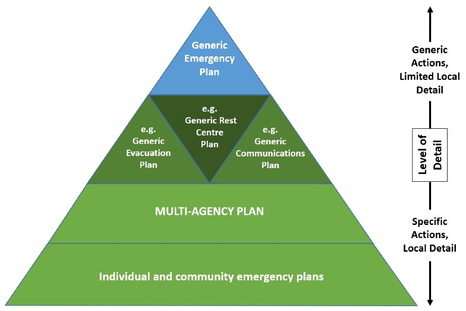
Figure 1: how a MAFP fits with other emergency plans
Developing the plan
To develop the MAFP, it is recommended that reference is made to Emergency Preparedness - Guidance on part 1 of the Civil Contingencies Act 2004, its associated regulations and non-statutory arrangements - Chapter 5: Emergency Planning (revised Cabinet Office, October 2011).
The process of working together to create the plan is as important as the end product. With this in mind, LRFs are encouraged to use “Task and Finish” groups or Flood Working Groups to lead the production of the plan and to encourage involvement of Category 1 and 2 Responders in its delivery.
Contributions from Category 2 Responders are critical in terms of considering assets and infrastructure in the area that may be impacted by flood water. For example: failure of a pumping station, contamination of water supplies or power failure over large areas are all consequences that need to be worked through. LRFs should identify all the suppliers of essential services in their areas and include these in the working group.
If there are Internal Drainage Boards (IDBs) within your area you need to factor in their response to a flood event. Although IDBs are not Category 1 or 2 Responders under the Civil Contingencies Act, they are a Drainage Authority and provide flood protection and water level management in areas of special drainage need (low-lying flood risk sensitive areas). They also operate control structures and pumping stations under their jurisdiction, so it is important they are consulted, and should be part of the LRF Flood Sub Group.
Though not a substitute for MAFPs, community flood plans can also be part of the approach to flood risk planning and management in some localities. The community engagement needed to develop such a plan is in itself a positive process. Further guidance on community flood planning is available from the Environment Agency and related information on community resilience can be found on the GOV.UK website Community Resilience Framework for Practitioners (Cabinet Office, September 2019). LRFs that have community flood plans should reference them in the MAFP with a link to where they can be found, or include them as Part 5 Appendices.
Consultation and cross boundary
To enable other responders to comment on the plan and, in particular, the links with their own plans, we recommend that the LRF or appropriate working group circulate the plan amongst its members. It is recommended that an agreed process is in place for sharing plans and protocols with neighbouring LRFs or catchment wide groups so that cross boundary issues can be carefully considered. The loss of infrastructure (energy, transport, water assets) often affects adjacent regions and organisational boundaries and jurisdictions are rarely spatially coherent.
You should consider the boundaries of your tactical information sections. These can be agreed between LRFs and included in multiple plans where multiple LRFs are affected. You may also wish to consider forming risk based groupings comprised of multiple LRFs to further encourage sharing and consistency for example, Trent Catchment Flood Group.
Format and style
The level of detail in a MAFP will depend on the needs of the responding organisations and the existence of other related emergency response plans. MAFPs should aim to provide a clear and concise, yet adaptable, response tool under which each responding organisation has clearly defined roles and responsibilities.
The plan should be intuitive so that any professional responder can pick it up and understand what action or response is required in different circumstances. For example, use colour-coded dividers or tabs to help users navigate through the plan together with appropriate use of maps, tables, diagrams and pictures.
Consider creating the plan as an interactive pdf where a contents page and links can be utilised.
Maps
Geographical Information System (GIS) software is a useful way to produce maps to include in your MAFP – for further information see a Guide to GIS Applications in Integrated Emergency Management (Cabinet Office, November 2008) on GOV.UK. To save having large numbers of maps in the hard copy of your plan, it is advised to create and save maps on ResilienceDirect. A mapping user guide is available on the ResilienceDirect User Section. You may decide that it would be useful to keep certain hard copies of maps in control rooms too. It is important for the LRF partners to agree what is needed and what will work for you in a flood emergency. It is useful to include maps for critical infrastructure, vulnerable buildings and location of reception centres etc.
The Environment Agency Flood Resilience teams can advise where it is appropriate to use the flood map and / or flood warning areas as the basis of the maps contained within the plan.
Protective marking
In order to facilitate ease of handling and storage of MAFPs, the lowest possible protective marking should be applied, consistent with the security of the contained information. Few MAFPs are likely to need a protective marking higher than OFFICIAL SENSITIVE. In many cases MAFPs can be marked OFFICIAL, or remain unclassified. Particular issues to consider are:
- information (including maps) flagging infrastructure as Critical National Infrastructure (CNI) and therefore increased classification
- sensitive personal information (for example, staff telephone numbers, log of key infrastructure, details of vulnerable people). It is advisable that this information is stored in a separate directory, on ResilienceDirect, or as an annex
- information which could jeopardise the security of physical assets (for example, access codes to buildings)
- if the content of the MAFP warrants it being protectively marked, can an edited, unclassified version be published - for example on the LRF’s website
Advice on which protective marking to apply can be found in the Security Policy Framework (revised Cabinet Office, May 2018) and government security classifications (revised Cabinet Office, May 2018) on GOV.UK.
For guidance on sharing personal data consult Data Protection and Sharing: Guidance for Emergency Planners and Responders (Cabinet Office, January 2007).
Location and storage
It is advised that the document is accessible via ResilienceDirect in order to aid document control and distribution, although hard copies should also be available for business continuity reasons and in incident control rooms.
If using ResilienceDirect, folder access will need to be agreed to ensure all organisations can view the plan quickly in an incident. The benefit of ResilienceDirect means individual organisations can update their relevant sections. Storing the plan as separate elements may be considered to improve security.
With minor modifications and the removal of personal data / confidential information, any plan based on this guidance could be suitable for general publication - for example on the LRF website.
Section 3: construction of your MAFP
The following section sets out, in detail, how to construct your Multi-Agency Flood Plan (MAFP). This is made up of a number of parts and elements and ALL should be included. As stated, including strategic Local Resilience Forum (LRF) wide information and tactical information on a District / Borough level (or other relative small boundary) together removes duplication and improves ease of access.
Part 1: context
This part should put into context emergency planning in your area or region and include the following aspects:
Purpose
why the plan is needed and if it supersedes other previous plans; set out broadly what the plan includes and excludes and its intended audience(s), thinking beyond LRF boundaries.
Aims and objectives
What the plan will and will not be able to achieve. For instance what successful implementation of the plan would look like, or the strategic and tactical outcomes expected in responding to a flood. The objectives that you set should follow the Specific, Measurable, Achievable, Relevant and Time-bounded (SMART) principle where possible.
Related plans
Cross references to other related and interdependent plans, or a brief diagram / list showing the plans and linkages between them. MAFPs should not duplicate detailed information that is already available elsewhere so cross referencing is encouraged. A MAFP should include only specific or additional information that is relevant to flood response.
Triggers and activation
A checklist detailing activation of the plan, differentiating between the LRF wide / strategic and tactical parts of the plan. Activation for a more strategic response may be linked to a set number of warnings issued in the LRF area. Activation for a more tactical response is expected to be lower, for example an Amber Flood Guidance, a specific warning issued, or a set water level reached or forecast to be reached. Further information on weather and flood products that may act as triggers can be found in The Department of Environment, Food and Rural Affairs’ (Defra) ‘National Flood Emergency Framework for England’. It is important to note that due to the speed of some incidents consideration to respond may be prior to the receipt of flood warnings. The Environment Agency will be able to give partner organisations forecast information for rivers and sea along with information about rainfall for potential surface water issues in advance of the traditional flood warning service.
It is useful if triggers clearly relate to levels of the response expected, both locally and nationally and as outlined under ‘multi-agency response’ in Parts 2 and 3.
Part 2: strategic - LRF wide information
The strategic part of a MAFP should set the over-arching framework for an LRF’s approach to addressing a flooding incident, in terms of planning, response and recovery. It is important that all responders participate in developing the strategic part of a MAFP and are signed up to it, so that it reflects a truly multi-agency approach.
2.1 Flood risk and impacts
Whilst detailed local information on flood risk and impacts should be held in Part 3 of the MAFP, it is useful to provide an LRF level overview. This information can be combined together into a flood risk and impacts summary sheet, together with associated maps. The following aspects should be included under flood risk and impacts, suggested sources of this information are summarised at the end of this section:
Source: LRF-wide overview of the different types / sources of flooding and their status within the Community Risk Register (CRR). It is advisable to consider a range of scenarios and potential combinations of scenarios. A broad understanding of how the local catchment and adjacent catchments respond to weather events may also be useful to identify the likely speed of events and response needed.
Risk levels: information should be consistent with the risk assessment information published in the related CRRs, and produced by lead local flood authorities. Many risk maps indicate a range of modelled levels of flood risk and observed flood extent. It is logical to consider the higher risk scenarios, but it is also advisable to recognise and plan for a range of lower risk levels. You may wish to relate to pre-determined flood warning triggers, where they exist.
Historical analysis: key LRF level flood history to give an idea of scale and speed of previous instances of flooding including surface water and drainage flooding problems. You may consider including links to Section 19 or similar reports that investigate previous instances of flooding in the area.
Location and extent: the area covered by the defined risk level(s), preferably depicted with the aid of map(s) showing the appropriate flood outline(s).
People (inc. vulnerable) & properties: LRF wide overview of numbers of people and properties within the defined risk level(s). This should include vulnerable people and those who would become vulnerable in a major flood for example, communities at risk of isolation, people who decide to stay in their homes despite evacuation. The Cabinet Office Guidance on identifying people who are vulnerable in a crisis (Cabinet Office, February 2008) should be referred to for more detail on GOV.UK.
Information on the location and needs of vulnerable individuals is held and maintained by various agencies / organisations and it is not necessary, or sensible, to catalogue or duplicate this information in the MAFP. The plan should be clear on the mechanisms for accessing information about vulnerable people and their locations. Key Infrastructure: LRF-wide overview of location and consequences of loss of key infrastructure within the defined risk level(s). The loss of some infrastructure assets as a result of flooding may have a significant impact across multiple sectors, and it is vital that this is assessed and prioritised. A mechanism for accessing further information should be included where applicable.
There are a number of sources you may be able to draw on for flood risk and impacts information:
- ResilienceDirect for the location of critical / key local infrastructure (such as roads, bridges, energy, health, telecoms and water)
- Environment Agency for river, sea and tidal flood risk; surface water risk and reservoir risk
- tide tables to include information on high tides, if applicable
- the Department for Transport has information on communities of >200 properties which may become isolated due to flooded roads. It obtains this information from Highways England if the flooded road is part of the strategic road network, or highways authorities and councils if the flooded road is local.
- surface Water Management Plans (where they exist), for the risk of surface water flooding and strategies for managing that risk - upper tier or single tier local authorities lead on these plans, in cooperation with other partners
- on-site and/or off-site emergency plans and flood maps from water companies
- risk assessment information from Control of Major Accident Hazards (COMAH) sites as part of determining and describing the impact of flooding
2.2 Multi-agency response
The following aspects should be included under multi-agency response:
Roles and responsibilities: set out the strategic flood specific actions, roles and responsibilities of responding agencies. Further information on the role of central government departments in flooding can be found in Defra’s ‘National Flood Emergency Framework for England’. Partners need to sign these off and agree to their individual expectations of responsibility, alongside statutory duties. Include when and how key plans and procedures will be implemented, such as flood advisory service telecons and location and opening of incident rooms and coordination centres. These activities should be in relation to your plan activation triggers, such as Flood Guidance Statement colouration, Met Office weather warnings etc. Cross reference to generic roles and responsibilities as appropriate.
Your MAFP should make reference to other plans regarding operating the coordination centres where they exist. However, if they do not the plan must include all the necessary information to find, gain entry to and operate the coordination centres, for example:
- address (include the post code for ease of use with satellite navigation systems)
- telephone number
- key holder information
- access details
- security information (for example, fobs / security codes) and parking arrangements
- number of personnel required to carry out key roles / responsibilities
- contingency facilities
Your MAFP should cross-reference to, or provide assurance of the responding organisation’s service and business continuity arrangements which will allow the continued delivery of essential services during a major flood, including utilities.
Cross-reference to, or provide assurance of plans for any pre-defined or ad-hoc public response roles, such as flood wardens and volunteers.
Any specific detailed roles / actions to be taken in District / Borough / Communities should be included in Part 3 under ‘Roles and responsibilities’.
Mutual and Military aid: document the procedure for managing cross boundary mutual aid. As severe events can escalate quickly beyond local capabilities, it is important to be clear where to seek additional assistance from other areas and recognise the importance and benefits of requesting aid at the earliest opportunity. Include the procedure for requesting military aid, note however that plans should not be based on the assumption of military assistance. Arrangements for military support and assistance are detailed in Joint Doctrine Publication 02 ‘UK Operations: the defence contribution to resilience and security’ (revised Ministry of Defence, February 2017) on GOV.UK. Where possible highlight the anticipated key strategic needs and uses for any mutual aid resource received such as:
- emergency response specialists to strengthen coordination centres
- provision of logistic planning / support or additional personnel to warn and inform
- specialist resources such as high volume pumps
You may wish to cross reference to, or provide information on accessing resources from the Flood Rescue National Asset Register, as detailed in section 2.3 ‘response equipment’.
Evacuation and sheltering: cross reference to the appropriate existing generic plan. Consider recording the LRF-wide planning assumptions specific to flood for evacuating and sheltering people at risk, such as:
- flooded roads and implications / mitigations for determining safe evacuation routes
- specialist evacuation transport in flooded areas and mechanism for requesting
- managing evacuated residents and displaced motorists / rail passengers
- considerations for security around long-term evacuated properties
The HM Government ‘Evacuation and shelter guidance’ (revised Cabinet Office, January 2014) should be referred to for more detail on GOV.UK. Detailed local arrangements should be covered in Part 3.
Health and Safety (H&S): include the range of risks associated with working in or nearby to floodwater and control measures where appropriate. All responding organisations, including voluntary agencies should be aware of these, such as:
- health issues when contact is made with contaminated floodwater
- risk of electrocution
- hidden objects or trip hazards beneath the water
- power of water and how easy it is to become unbalanced; hypothermia or drowning
Further information on health risks associated with flooding can be found in Defra’s ‘National Flood Emergency Framework for England’.
All organisations need to ensure that they have appropriate and adequate resources that can be sustained over a protracted period if required - in particular, staff resource, personal protective equipment and accommodation. This needs to be clearly set out, or cross reference made to the relevant plan.
In all cases, individuals and teams that are expected to play a role in flood response and recovery should receive appropriate training in relevant H&S policies and procedures. You may wish to refer to these policies and procedures in your MAFP.
2.3 Response equipment
Provide information on the resources available to respond to a flood within the LRF, and the mechanisms for accessing the latest up-to-date information as appropriate. It should be an overview of what organisations have for response, but it may be worth including resource availability for planning and recovery. Resources should include, personnel and equipment. The following should also be covered:
National Fire Chief Council (NFCC) – National Resilience: major flood events are likely to require deployment of a range of specialist national resilience assets, such as high volume pumps and Enhanced Logistic Support vehicles. This will be managed via the Fire and Rescue Service National Coordination and Advisory Framework (NCAF). The Home Office ‘The National Coordination and Advisory Framework (NCAF) England’ (revised, April 2019) publication should be referred to for more detail.
Defra Flood Rescue National Asset Register: LRFs can access the Flood Rescue National Asset Register, which is a comprehensive listing of all flood rescue assets who maintain availability for national deployment. The register includes flood rescue “B” and “C” typed teams, and flood rescue tactical and strategic advisors. “B” and “C” typed teams are able to carry out search operations within water environments, technical water rescue, and in-water operations. “B” teams operate using powered boats and “C” teams non-powered boat operations. All the asset teams have to sign a Memorandum of Understanding with Defra and comply with the standards as set out in the Flood rescue concept of operations (Defra, November 2019).
The standards within the Flood Rescue Concept of Operations (FRCO) are recognised internationally as best practice. It is recommended that local flood rescue assets identified within the LRF, but not on the national register, meet the standards in the concept of operations set out in this document to ensure safety of all responders, the community and enable a scalable approach.
Assets on the asset register are currently mobilised by the fire & rescue services’ National Resilience Fire Control (NRFC). Requests for any of the Defra or fire and rescue service assets can be made by any LRF lead agency. Requests should be made through the local fire and rescue control room who will contact NRFC.
Like many agencies the fire and rescue services have additional flood rescue assets including assets and responders that meet the standard of “D” team type (wading rescue capability) as detailed in the FRCO. Accessing the flood rescue national asset register should be referenced in your MAFP, along with the process of seeking resources using the flood rescue tactical advisers.
Detail of any specific local resources or equipment and plans should be detailed in Part 3.
2.4 Communication and information exchange
A separate Communication Plan, or a Generic Emergency Plan, may contain arrangements to communicate and exchange information with each other, nationally, the public, and media. But, if this is not the case, it is recommended that your MAFP should include the communication and exchange of information with:
Local responders: exchange between all agencies responding to a flood (where not covered in another LRF plan or different in flood response). Include triggers and the process for sharing digital data, information, maps and site observations across all agencies across Strategic / Tactical / Operational levels. ResilienceDirect is becoming widely accepted as a reliable and widely available tool for sharing up to date information and plans between responders before and during flood events.
Cross-refer to LRF telecommunication plans where they exist. Where they don’t exist, information should be included specifically for floods on how communications between responding organisations (including Strategic Coordination Groups (SCGs) and Tactical Coordination Groups) would work in the case of networks failing.
National government: exchange between the LRF area and national government, enabling an understanding of the level of impacts and any support needs. This can be gathered locally and passed on through Environment Agency (EA) and the Ministry of Housing, Communities and Local Government Resilience teams who will be engaged in your SCGs. In more serious events when the National Flood Response Centre and the Cabinet Office Briefing Rooms are convened, clearly articulating the local plan to deal with the current event and any needs for additional support will help government prioritise what may be limited national resources. Further information on recording the impacts of flooding can be found in Defra’s ‘National Flood Emergency Framework for England’.
Public: methods and responsibilities for warning and informing the public. A MAFP should not contain the specific arrangements for issuing flood warnings as this is carried out by the EA, but you should include principles for raising the public’s awareness about the risk of flooding, which could include:
- GOV.UK website for checking whether a property is in a flood risk area, river levels online (includes forecast river levels in some locations), and warning information
- EA flood warning service; available in most areas at risk of flooding from rivers and the sea for those registered on the flood warning system. Consider signposting to the standard flood warning codes and corresponding message content, which can be found in Defra’s ‘National Flood Emergency Framework for England’.
- Online Flood Applications (Apps)
- EA public awareness campaigns
- highlighting measures that can be taken to be better prepare and help people and properties more resilient, including advice during flooding
- helpline and information lines
- pre-prepared announcements, including evacuation
This should take into account the varying experience / history of flooding, and how to communicate with people with hearing, visual and other disabilities or a limited ability to speak English.
Include plans to communicate with vulnerable people who are dependent on their telephone in the event of network failure. There is a need to consider an alternative approach to warning and informing vulnerable people. Such warnings must be accessible, requiring several tailored communications approaches
Key service providers: details of communication in an incident with any bodies, businesses, or service providers with key facilities or services.
Media: reference any media plans. You may want to include how you handle media requests and social media at a strategic level across all organisations, any pre-prepared media releases, and who will lead. Further information communicating via the media at a national and local level, including social media, can be found in Defra’s ‘National Flood Emergency Framework’.
2.5 Recovery
The National recovery guidance (Cabinet Office, June 2013) has been published on GOV.UK, and should be referred to. The guidance provides advice on how the recovery phase can be co-ordinated (including the handover from response to recovery). It also includes a draft Terms of Reference for a Recovery Coordination Group (RCG) and suggestions on sub-group structures.
Recovery planning should start during the response phase of the emergency. If there is no existing generic recovery plan, then the MAFP should describe how the recovery from a flood incident is to be managed in the short and long term, and the RCG strategy.
Where an extended recovery period is anticipated, Ministry of Housing, Communities and Local Government (MHCLG) will deploy Recovery Liaison Officers (RLOs) to act as a single point of contact between local authorities and central government – including sitting on the RCG - for the duration of the recovery period.
The RCG will need to prioritise the various needs identified by each sub-group and allocate resources appropriately so that the community returns to normality as soon as possible. Common issues that follow flooding for consideration are:
Humanitarian:
- restoration of power, communications and water
- humanitarian assistance needs including homeless / displaced residents and psychological impacts
Environmental:
- disposal of animal carcasses if farmland is flooded
- disposal of flood damaged personal property
- disposal of silt, gravel and other flood debris
- disposal of contaminated sand bags
- saline intrusion of fresh water in Sites of Special Scientific Interest (SSSI)
- pollution if sewage / industrial sites are flooded or pollution from flooded vehicles, stored fertilisers etc.
Economic:
- agricultural impacts if farmland is flooded
- business impacts if a tourist area
- business impacts of large industry
In a severe weather event with significant wide area impacts, local authorities may need central support to help their communities and businesses return to a sense of new normal. Authorities should try, as far as possible, to keep the designated RLO informed of any property, infrastructure, or wider impacts that may be cause for particular concern. Information provided in the early stages of an event will help inform cross-government discussions around the need for particular recovery support.
To serve as a framework for flood recovery funding when needed, MHCLG has published the Flood recovery framework: guidance for local authorities in England (December 2017) on GOV.UK, which sets out a core package of business and community recovery support to be administered rapidly by local authorities.
The core package is made up of several schemes: community recovery grant; business recovery grant; council tax discount scheme; and business rates relief scheme. Grants range from £500 per eligible household, to £2,500 per eligible businesses. Where Ministers determine central recovery support is appropriate, funding under these schemes can be deployed quickly to local authorities through standard grant funding mechanisms. Where practical, local areas are encouraged to maintain an overview on reporting across their area to ensure a coordinated approach.
Part 3: Tactical - District / Borough / Community information
Effective MAFPs at the strategic level need to be underpinned by robust tactical plans. Some local resilience forums may find it appropriate to include multi-agency tactical plans in the MAFP; others might have single agency tactical plans held separately. It is up to individual LRFs to decide what best fits their needs. Whether developed within the document or in single agencies, tactical plans should be robustly developed, maintained and exercised to support the coordination of an effective multi-agency response.
This guidance suggests elements of effective tactical MAFPs; equally most elements of it can also be applied to single-agency plans.
Information should be relevant to your defined (and likely multiple) district / borough / community wide levels. Geographical areas to consider covering in your MAFP can be determined using the following guidelines. Note these are not intended to be absolute figures and are intended as a guide:
- the degree of flood risk to an area is a ‘medium’ (between 1% and 3.3%) and / or ‘high’ (>3.3%) chance of flooding in any one year, according to the Environment Agency’s (EA’s) Flood Map
- there are >250 residential and / or business properties that are at ‘medium and / or high’ risk of being flooded from river, coastal / tidal, surface water, and groundwater. For coastal / tidal, this should be where flood protection schemes only afford protection up to a 1 in 75 standard (floods of 0.75% chance in any one year would exceed the scheme)
- the consequences of flooding in zones of ‘medium and / or high’ flood risk are such that there would be severe disruption to >1,000 people for a period of time (including people trapped in their cars on main transport routes for 8hrs or more; or loss of electricity, gas or fresh water supplies for 24hrs or more)
- the impact of flooding in zones of ‘medium and / or high’ flood risk would include making certain assets, sites or critical infrastructure unavailable for a period of time. Unavailability of such would lead to a risk to life or health – in particular those vulnerable members of the community (elderly, sick, disabled or infirm). Plus, the consequences of flooding of these assets, sites or critical infrastructure would lead to additional significant disruptive challenges (for example, the loss of essential services) that would take 3 or 4 days to put right
- the impact of flooding and risk to life would be significant due to the rapidly responding nature of the catchment
EA colleagues will be able to advise LRFs on the degree of flood risk (including rapid response catchments), flood protection schemes, and the number of properties at risk in each category.
3.1 Local flood risk and impacts
This information lends itself to being combined together into flood risk and impacts summary sheets for the defined areas, together with associated maps. For each district / borough / community, you should include:
Source
The different types / sources of flooding and their status within the Community Risk Register (CRR) within the defined areas. Consider a range of scenarios and potentially combinations of scenarios. A broad understanding of how the local catchment and adjacent catchments respond to weather events may also be useful to identify the likely speed of events and response needed.
Risk levels
Information should be consistent with the risk assessment information published in the related CRRs. Consider the higher risk scenarios, but it is also advisable to recognise and plan for a range of lower risk levels. You may wish to relate to pre-determined flood warning triggers.
Historical analysis
Key flood history, to give an idea of scale and speed of previous instances of flooding including surface water and drainage flooding problems.
Location and extent
The areas covered by the defined risk level(s), preferably depicted with the aid of map(s) showing the appropriate flood outline(s). In communities with significant flood risk, it may be necessary to split communities into smaller sub-areas presented over multiple sheets.
People (inc. vulnerable) and property
Numbers of people and properties, including vulnerable people and those who would become vulnerable in a major flood for example, communities at risk of isolation. Cross reference contacts at agreed key organisations that maintain and update the latest information.
It is recommended that an appropriate map showing the likely whereabouts of vulnerable groups (for example, schools, nurseries, care homes) is included for each area. It is advisable to contact operators of those sites to see if they have any existing arrangements in place, including evacuation plans. If so, these should be recorded. It is also important to record the contact details of certain key people, such as key holders, flood wardens and community groups.
Key infrastructure
Location and consequences of loss of infrastructure within the defined areas. Consider including a table and / or map of key infrastructure for each area, knowledge of when it will be affected and any actions taken to protect it. A mechanism for accessing further information should be included as appropriate.
3.2 Multi-agency response
Role and responsibilities
Set out any detailed flood actions, roles and responsibilities of responding agencies or the public (including established and ad-hoc flood wardens or volunteers) in relation to these triggers, specific for the defined areas. For example, the police will close X road at Y, the Environment Agency (EA) will close the flood gates at X. Cross reference to, or include any specific information on tactical or operational coordination centres, and plans for (or assurance of plans for) service / business continuity arrangements (including local utilities) within the defined area. You may wish to link to community level plans if they exist.
Seeking mutual and military aid through the SCG
Where possible highlight the anticipated deployment of any mutual aid resource, including military aid should it be available.
Evacuation and sheltering: record any specific arrangements for evacuating and sheltering people at risk from flooding in the defined areas, such as:
- areas or zones at risk for flooding for order of evacuation
- safe evacuation routes and rendezvous points, considering flooded road networks, preferably marked on a map
- vehicles and resources required (including any specialist flood equipment) and how to access for evacuation
- traffic management arrangements for known flood prone roads
- shelters/reception centres outside of flood areas to accommodate displaced victims (such as motorists and rail passengers), plus any valuables they may bring, including essential medication and pets; distribution of supplies and services
- a method of tracking flood displaced people
- details of flood evacuation plans operated by others
- issues regarding the longer-term recovery of people, supplies and services from flooding
- issues regarding the evacuation and sheltering of pets, welfare of livestock and zoos from flooding
- security issues around long-term evacuated properties due to flood damage / flood isolation
- the needs of faith, religious, cultural and minority ethnic groups and communities and foreign nationals in flooding situations
It is recommended that the EA is consulted for advice on flood depth information which could be useful for planning evacuation routes, where available.
The relevant local authority team would identify the most appropriate rest centres. Reception / rest centres should be marked on an appropriate map in your plan.
Consideration must be given for transient populations. For example, those individuals that are on holiday in tourist areas and caravan parks that may be impacted.
For further guidance on evacuation planning, refer to the Evacuation and shelter guidance (revised Cabinet Officer, January 2014) on GOV.UK.
Health and Safety (H&S): list any specific H&S risks in the defined areas. For example, any COMAH sites that can cause potential issues.
3.3 Response equipment
Provide information on the resources available to respond to a flood within the defined areas, which may include resource requirements for recovery. Resources should include, personnel and equipment. Include mechanisms for accessing the latest up-to-date information as appropriate.
Aspects to consider are:
- suitable locations for emergency response equipment. Additional protection that can be provided by deployment of emergency response equipment in suitable locations. Suitable and unsuitable locations should be clearly identified. For example if ground conditions are unsuitable some types of temporary barriers cannot be installed. Understanding the extent of suitable locations will inform the quantities of equipment that may need to be obtained
- preparation, procedures, and timescales to mobilise and resources for obtaining and deployment of different types of equipment (temporary barriers, pumps etc.), including mutual aid. Where emergency response equipment may be suitable for use, site specific temporary or permanent preparations might be required ahead of deployment (this can involve longer term civil works). It is important to understand the procedures for deployment of different equipment and where specialist machinery or staff will be required for deployment.
- while you should locally have available equipment and resources, you may also need to rely on equipment or resources from more distant locations, including any you may receive through mutual aid. It is therefore important that you understand the additional time that will be needed to request, agree and mobilise the access to and movement of such resources
- contingency actions including in event of equipment / structure failure or overtopping. During incidents, particularly more severe events, both equipment and structures can fail (or be close to failure) for a number of reasons. The plan should identify and include any necessary contingency actions that might need to be taken in the event of either overtopping or such a failure
- any specific requirements around operational integration at ground level between agencies
- any community-led response equipment in the area
3.4 Communication and information exchange
Include any local details on communication and information in the defined areas or at a tactical level.
Local responders: any specific communication arrangements between all agencies responding to a flood in the defined areas. You may want to include how information at a tactical level is passed to strategic level, and points of contact at Tactical coordination centres.
National government through the SCG: any specific arrangements to enable communication and exchange of information within the defined areas to LRF level, and national government.
Public: any arrangements within the defined areas for the public, For example, detailing communication with community or flood wardens, lists of flood warnings available, sirens.
Key service providers: details of communication in an incident with any locally-based bodies, businesses, or service providers with key facilities or services in the defined areas.
LRF media cell: any specific media arrangements within the defined areas.
3.5 Recovery
Consider any specific flood recovery information you wish to include for the defined areas. This may include resource that may be required in the long term to return areas to original state and any specific humanitarian, environmental (for example, waste sites) and economic concerns (for example, building at risk of flooding that could impact on tourism) for the defined areas.
Part 4: Plan maintenance and review
This part should contain information outlining plans for the maintenance, review, training, and exercising of your MAFP.
Maintenance
After sign-off, the MAFP must be maintained to ensure that if flooding occurs, or is likely to occur, responders are able to perform their functions to deal with it. Plan maintenance procedures must be developed and published to ensure that responsibilities are clear and plans are kept up to date.
Revisions
Keep a record of any key revisions and the distribution group for plan updates, including how they will be notified. A ‘Document control / distribution’ table is recommended.
Assurance
All organisations / departments that contribute to the plan should approve the MAFP, with support from their respective leaders. This guidance is a benchmark for self-assurance that requirements are being met. Final sign off should be agreed by the LRF as a partnership group.
Partners within LRFs should actively seek the views of practitioners from other LRFs. Peer review of this kind is encouraged and will help promote consistency across LRFs.
In addition, the Environment Agency (EA) will provide support by performing a health-check on MAFPs once every three years. This will commence one year after the formal publication (post-consultation) of this guidance, to allow LRFs time to implement changes and test their plans.
Training and exercising
Include a proposed training and exercising schedule your MAFP. This includes the roles of the Strategic Coordination Group and Tactical Coordination Group. It is essential to train responding officers in their roles and responsibilities before they need to use the plan during an exercise or an actual event. It is recommended that exercising this plan is undertaken whenever there is a major revision, and at a minimum of every three years. Exercises aim to validate the plans, train staff and test procedures. Such exercises may be internal, or tied into other multi agency exercises organised by the LRF / across LRFs sharing a common risk. They should confirm the roles and responsibilities of responding agencies, as well as the adequacy of communications, resources and equipment.
Please refer to the Exercise planners guide (Cabinet Office, January 2006) on GOV.UK for further information on exercising your plans.
Part 5: Appendices
Where not stored elsewhere (for example on ResilienceDirect) and able to be cross referenced, you may wish to consider including appendices, such as:
- a list of key internal and external contacts, including job titles (as opposed to individuals’ names). A separate contacts database / directory is however recommended, which will allow for better control of access and ease of updating
- community plans
- pdf maps, if not using ResilienceDirect Mapping
Any enquiries regarding this publication should be sent to us at floodemergencies@defra.gov.uk