Notice by the Secretary of State under section 52 [and 55(1)] of the National Parks and Access to the Countryside Act 1949: Esk Boathouse, Castletown, Cumbria
Updated 16 January 2026
Applies to England

© Crown copyright 2026
This publication is licensed under the terms of the Open Government Licence v3.0 except where otherwise stated. To view this licence, visit nationalarchives.gov.uk/doc/open-government-licence/version/3 or write to the Information Policy Team, The National Archives, Kew, London TW9 4DU, or email: psi@nationalarchives.gov.uk.
Where we have identified any third party copyright information you will need to obtain permission from the copyright holders concerned.
This publication is available at https://www.gov.uk/government/publications/coastal-access-section-52-notice-for-gretna-to-allonby/notice-by-the-secretary-of-state-under-section-52-and-551-of-the-national-parks-and-access-to-the-countryside-act-1949-esk-boathouse-castletown
Introduction
On 25 July 2016 Natural England submitted a compendium of coastal access reports relating to the stretch of land between Gretna and Allonby to the Secretary of State for Environment, Food and Rural Affairs under section 51 of the National Parks and Access to the Countryside Act 1949 (“the 1949 Act”), pursuant to its duty under section 296(1) of the Marine and Coastal Access Act 2009 (“the 2009 Act”).
On 1 October 2021 the Secretary of State gave notice under Section 52(2) that parts one to three of the Gretna to Allonby proposals, between Gretna and north of Kirkandrews-on-Eden, east of Drumburgh Castle to west of Kenley Cottage, Anthorn and Rumbling Bridge to Allonby were approved (“the approved coastal access provisions”).
On 9 May 2022, under section 55(1) of the 1949 Act, Natural England submitted a coastal access variation report relating to proposed changes to the approved coastal access provisions (“the coastal access variation report”) to the Secretary of State for Environment, Food and Rural Affairs. The coastal access variation report proposed changes to the approved coastal access provisions at Esk Boathouse near Castletown in Cumbria.
In reaching their determination under section 52 of the 1949 Act the Secretary of State has considered:
a. proposed changes to the England Coast Path at Esk Boathouse, Castletown, Cumbria - Natural England’s coastal access variation report submitted to the Secretary of State on 9 May 2022
b. in accordance with paragraph 16(1)(d) of the Schedule, representations made by a person within paragraph 2(2)(b) to (f) of the Schedule, and Natural England’s comments on those representations which it sent to the Secretary of State on 6 July 2023
In this notice –
(a) “objection” means an objection about the coastal access report which is made under paragraph 3 of the Schedule
(b) “representation” means a representation about the coastal access report which is made under paragraph 7 of the Schedule
Secretary of State’s approval of coastal access proposals
The Secretary of State has determined to approve in full the proposals for the route and associated coastal margin as set out in the coastal access variation report, in relation to which no objections were made.
The approved variation to the route is set out at Annex B.
The Secretary of State has made available at www.gov.uk:
a. A copy of this notice
b. Representations made by a person within paragraph 2(2)(b) to (f) of the Schedule, and Natural England’s comments on those representations, which it sent to the Secretary of State on 6 July 2022
Natural England has also made available here:
c. proposed changes to the England Coast Path at Esk Boathouse, Castletown, Cumbria – the coastal access variation report.
Annex A: Conclusions and observations on representations
Representation No: MCA/GAL/VR10/R/1/0883
Name of representation:
Environment Agency
Length Report and route section(s):
VR10, GAL-MR1-S001 to S003
Secretary of State’s conclusion and observation:
Secretary of State welcomes confirmation Natural England will forward the Environment Agency’s advice to Cumbria County Council.
Representation No: MCA/GAL/VR10/R/2/0023
Name of representation:
Historic England
Length Report and route section(s):
VR10, GAL-MR1-S001 to S003
Secretary of State’s conclusion and observation:
Secretary of State welcomes confirmation that the proposals will not affect the World Heritage Site.
Annex B: Approved variation at Esk Boathouse
The approved variation is for 435m of the approved route to move up to 200m further seaward.
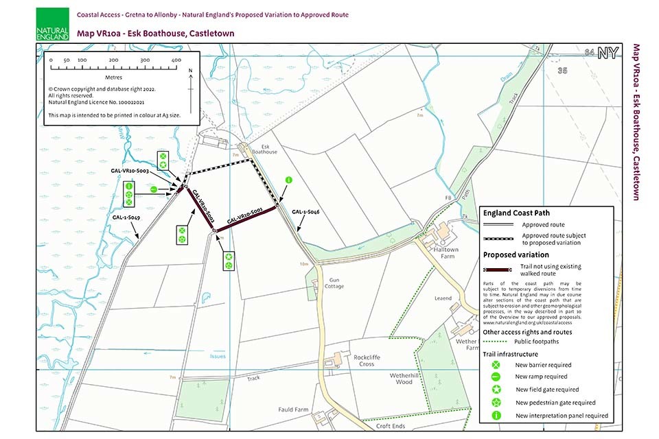
Map VR10a: Natural England's proposed variation to the approved route at Esk Boathouse, Castletown
Table 2.3.1: map VR10a - Esk Boathouse
Key notes on table:
Column 4 – ‘Yes – see table 2.3.2’ means roll-back is proposed, but refer to that table for our likely approach to implementing it for this route section. This is because a more complex situation exists in this case and consideration must be given to how roll-back may happen in relation to, for example, excepted land or a protected site.
Column 5a - Certain coastal land types are included automatically in the coastal margin where they fall landward of the trail if they touch it at some point. The relevant land type (foreshore, cliff, bank, barrier, dune, beach, flat or section 15 land – see Glossary in Annex B to the 2016 Overview) is shown in this column where appropriate. “No” means none present on this route section.
Columns 5b and 5c – Any entry in these columns means we are proposing to align the landward boundary of the coastal margin on this route section with the physical features shown in 5b, for the reason in 5c. No text here means that for this route section the landward edge of the margin would be that of the trail itself - or if any default coastal land type is shown in 5a, that would be its landward boundary instead.
| 1: Map | 2: New route section numbers | 3: Current status of route sections | 4: Roll-back proposed? (See part 8 of 2016 report Overview) |
5a: Landward margin contains coastal land type? | 5b: Proposal to specify landward boundary of margin | 5c: Reason for landward boundary proposal |
|---|---|---|---|---|---|---|
| VR10a | GAL-VR10-S001 | Not an existing walked route | Yes – see table 2.3.2 | No | Fence | Clarity and cohesion |
| VR10a | GAL-VR10-S002 | Not an existing walked route | Yes – see table 2.3.2 | No | Fence | Clarity and cohesion |
| VR10a | GAL-VR10-S003 | Not an existing walked route | Yes – see table 2.3.2 | No |