Arun and Western Streams abstraction licensing strategy (ALS)
Published 22 June 2022
Applies to England

© Crown copyright 2022
This publication is licensed under the terms of the Open Government Licence v3.0 except where otherwise stated. To view this licence, visit nationalarchives.gov.uk/doc/open-government-licence/version/3 or write to the Information Policy Team, The National Archives, Kew, London TW9 4DU, or email: psi@nationalarchives.gov.uk.
Where we have identified any third party copyright information you will need to obtain permission from the copyright holders concerned.
This publication is available at https://www.gov.uk/government/publications/arun-and-western-streams-abstraction-licensing-strategy/arun-and-western-streams-abstraction-licensing-strategy-als
1. About the licensing strategy
1.1 Overview
This abstraction licensing strategy (ALS) sets out how we manage new and existing abstraction and impoundments within the Arun and Western Streams catchment. It provides an overview of how water resources are sustainably managed to:
- provide water for abstraction
- protect the environment
Managing water abstraction provides the national overview describing the technical explanation, legal and policy requirements behind the abstraction licensing strategies.
1.2 How is the licensing strategy set out?
The following is a summary of what each section covers:
Catchment overview - sets out additional information about the catchment and the influences and pressures on water availability.
Water resource availability - explains how much water is available for abstraction in the catchment.
How we manage water resource availability - explains the local licensing approach for the catchment which is summarised in table 2. This includes the potential water available for licensing and the restrictions that would be required.
Managing the catchment together - explains the actions we are taking where abstraction is currently unsustainable in the catchment. Approaches to ensure sustainable water management in the future are outlined, including information on licence trading.
Related links - are listed for further information on water resource management.
Glossary – explains technical terms included throughout this document.
Contact details – on how to get in touch.
Note: whilst our assessment tools are continuously updated, we aim to update this document on a 3 year basis. Therefore some details within this document, for example hands off flow (HoF) values may be outdated. Use this document as a guide to water availability, for up to date and detailed advice, see the contact details section.
1.3 Collaborative and sustainable water management
Our long term goal is to manage catchments so that there is sufficient water for people and the environment in the face of climate change. To help address this we need a stronger collaborative focus for water resources. We are working with abstractors and catchment groups to:
- develop local solutions to existing pressures
- prepare for the future
The Arun and Western Streams catchment was selected as a priority catchment in the Defra water abstraction plan. This plan sets out how the government will reform the way we manage water abstraction, to protect the environment and improve access to water.
Background information on the priority catchment project is available in section 2, the catchment overview. Further details and links on approaches trialled in this catchment are provided in section 5, managing the catchment together.
1.4 Applying for an abstraction licence
If you are considering applying for an abstraction or impoundment licence, the abstraction pages on GOV.UK provide further advice. The different types of water resources licence that can be applied for are:
- full licence – for most types of water abstraction over 20 cubic metres a day
- transfer licence – to move over 20 cubic metres of water a day from one source to another without intervening use
- temporary licence – to abstract more than 20 cubic metres of water a day over a period of less than 28 days
- impounding licence – to create or remove an impoundment structure such as a sluice, weir or dam
Before applying for an abstraction licence for a groundwater source, any applicants are also likely to need a groundwater investigation consent (GIC). This is under section 32 of the Water Resources Act. This allows you to find out what water may be available, and whether it is suitable for your needs.
Applications can also be made to vary the conditions on an existing abstraction licence. Many of the principles that apply to new applications will also apply to variations to existing licences. Guidance on how to apply can be found on the apply for a water abstraction or impoundment licence pages.
2. Catchment overview
2.1 Landscape and land use
The Arun and Western Streams catchment covers an area of 1,484km2 mostly in West Sussex. Urban development is concentrated on the coastal plain (see Map 1). It includes the towns of:
- Worthing
- Littlehampton
- Bognor Regis
- Chichester
Map 1 also shows the location of the major rivers and assessment points on them.
Map 1: the catchment of the Arun and Western Streams showing the network of major rivers and the locations of major towns
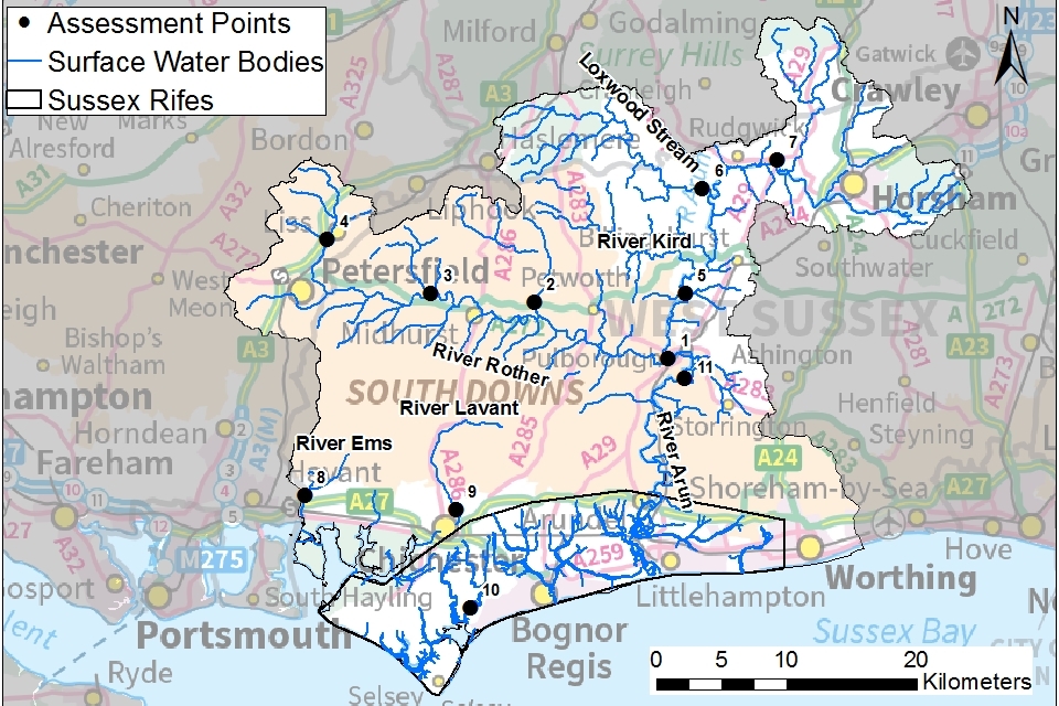
© Environment Agency copyright
The Chalk of the South Downs forms a ridge across the area with the Rother and Arun valleys to the north. Smaller towns like Petersfield, Midhurst and Horsham lie adjacent to the river valleys in the north of the area. The majority of the catchment is rural with a large agricultural and horticulture sector making good use of high levels of sunshine, a mild climate and high quality soils.
-
population: 536,000 (estimated from ONS 2019 mid-year local authority estimates)
-
1,000 farms covering 83,789 hectares of farm land (Defra farm statistics)
Land use statistics based upon LCM2019 © NERC (UKCEH) 2020:
| Land Use Type | Proportion of catchment (%) |
|---|---|
| Permanent grassland | 40% |
| Arable | 21% |
| Urban | 12% |
| Forested | 24% |
| Other | 3% |
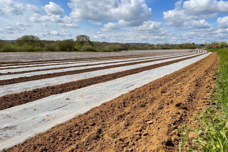
The photograph shows a field in the Rother Valley. It has sandy soils and intensive cropping which is common in this area. Many of these types of fields are irrigated using water from the River Rother.
2.2 Water resources
Groundwater and surface water
The Chalk and the Lower Greensand aquifers represent an important groundwater resource. They provide the numerous springs and streams which support surface water flows and wetlands.
The main rivers in the Arun and Western Streams catchment are:
- River Arun
- Western Rother
- River Ems
- River Lavant
- Coastal Rifes
The River Arun rises from springs to the east of Horsham. It has a ‘flashy’ character with high peak flows but low summer flows. Discharges from water treatment works at the top of the Arun introduce a significant volume of water.
The Western Rother feeds into the tidal River Arun at Pulborough. It is fed by groundwater coming from the Lower Greensand aquifer with small springs also rising from the Chalk of the South Downs. These groundwater inputs mean the Western Rother has much higher summer flows than the Arun. Winter flows can also be high following rainfall.
The Ems and Lavant are small chalk streams which are affected by groundwater abstraction. Portsmouth Water operate an augmentation scheme to top up summer flows in the River Ems.
‘Rifes’ are small streams on the West Sussex coastal plain. These flow directly out to the coast and are often influenced by the tide. The hydrological regime of the rifes is complex and unique to the individual stream.
Abstraction
169.7 million m3 of water is licensed to be abstracted per year (based on data in Dec 2021)
There are:
- 235 licensed abstractions
- 48 licences with hands off flow (HoF) restrictions at 7 gauging stations
- 53% of the catchment underlain by principal aquifer
55% of water licensed for abstraction is taken from groundwater sources and 45% from surface water. Map 2 shows that most of the surface water abstractions take water from the River Rother or rifes along the coast. Groundwater abstractions tend to be from the Chalk aquifer to the south and the Lower Greensand aquifer in the centre of the area. There is very little abstraction in the Upper Arun or along the South Downs ridge.
Map 2: licensed groundwater and surface water abstractions in the Arun and Western Streams catchment
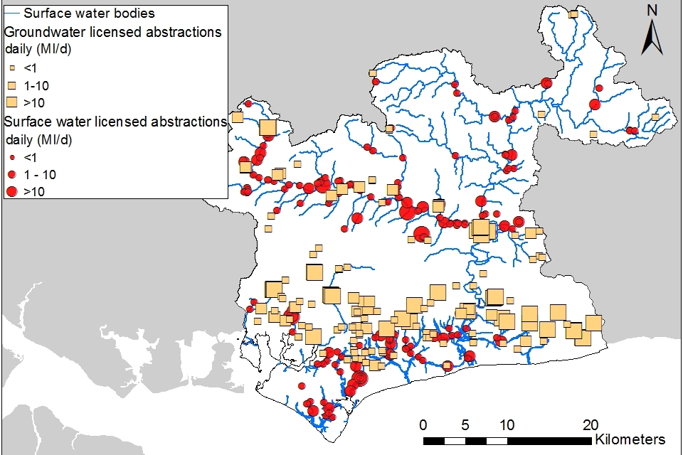
© Environment Agency copyright
The largest abstraction by volume are those taken for public water supply. Southern Water, Portsmouth Water and South East Water all have public water supply abstractions in this area. Most of the water is taken from groundwater.
The agriculture and horticulture sector hold the largest number of licences in the Arun and Western Streams area with 67% of the licences.
| Abstraction licence sector | Proportion of total licensed quantity (%) |
|---|---|
| Public water supply and other potable uses | 63% |
| Power generation | 22% |
| Agriculture | 12% |
| Amenity/environmental | 2% |
| Industry | 1% |
Not all water that is abstracted is removed from the local environment. Some licences allow water to be used for non-consumptive purposes where the water is returned to the environment nearby. These types of licences are usually large surface water licences for purposes such as power generation.
2.3 Climate change
This strategy is a tool to make informed decisions on the choices abstractors make about their use of water. We want this strategy to help abstractors to better understand the local water resource situation. This will help them to plan their water use and become more resilient in the face of climate change.
The projected climate change impacts on rainfall and river flow for the Arun and Western Streams Area by the 2050s are for:
- rainfall to decrease by 44% in the summer but increase by 44% in the winter
- low flows to be 75% lower but peak river flows to be 50% higher
Climate change projections are estimated using data from UKCP09, consistent with a 4ºC rise by 2100. Further details on the assumptions used can be found in the Environment Agency Climate impacts tool. Further information is also provided in section 5.3 where more detailed assessment of climate change impacts on the Western Rother is described.
2.4 Environment and sustainability
Protected and designated areas
The Arun and Western Streams catchment has 89 designated protected areas of local and national environmental importance. These sites are protected by UK law because of their special ecological status. We must ensure that we do not authorise abstraction that will have an adverse effect on the designated habitats and species at these protected sites.
The catchment also includes locally important sites which may not be designated but are valuable habitats such as chalk streams and springs.
More information on protected sites is available in section 4, How we manage water resource availability.
River Basin Management Plans
The Water Framework Directive (WFD) regulations seek to protect and enhance the water environment. This is in line with the River Basin Management Plans (RBMPs) for the 8 river basin districts in England.
This abstraction licensing strategy ensures that we:
- meet RBMP objectives for water resources activities
- avoid deterioration within this catchment
We assess the impacts of new water abstraction applications to make sure that they comply with the regulations. We apply this approach to the water body in which the abstraction is located. It also applies to:
- all downstream surface water bodies that may be affected by any reduction in abstraction related flow
- adjacent groundwater bodies affected by any reduction in groundwater level
WFD status is assessed at a water body scale. Groundwater body status is assessed with a separate set of tests, with the status reported as either good or poor.
Arun and Western Streams Water Body Status
- 36 surface water bodies
-
12 surface water bodies where flow pressure does not support good status
- 8 groundwater bodies
- 3 groundwater bodies at poor quantitative status
2.5 Partnership working
The Arun and Western Streams catchment was selected as a priority catchment in the Defra water abstraction plan to explore:
- how the priority catchment approach works in the South East where water resources are under pressure
- collaborative approaches where farmers and water companies come together to develop new water resources
Since 2019, we have been working with water users and other partners exploring modern ways of managing water. We are working together across sectors including:
- public water supply
- agriculture
- environment
- flood risk management
This will deliver multi-functional outcomes which are good for the environment and people and business.
The Arun and Western Streams catchment partnership bring stakeholders together from a range of backgrounds to address issues in the catchment.
Water Resources South East (WRSE) is made up of an alliance of the 6 water companies that cover the South East region of England. Their aim is to secure the water supply for future generations through a collaborative, regional approach to managing water resources. WRSE’s ambition is to ensure an affordable, resilient and sustainable water supply for:
- the public
- industry
- the natural environment
We have been involved in the multi-sector working group to discuss how to build long term resilient water supplies for all water users.
3. Water resource availability in the Arun and Western Streams catchment
3.1 Surface water availability
The method for calculating the water resource availability is explained in Managing water abstraction. Water availability is calculated at selected assessment points (APs). The maps show the water availability calculated at the AP, local water availability may differ.
There are 11 APs in the Arun and Western Streams ALS:
- AP1: Lower Rother, including the western Rother and River Arun downstream of Pallingham weir
- AP2: River Lod
- AP3: Upper Rother, including Western Rother, Hammer stream, Elstead Stream, Harting Stream and Stanbridge Stream
- AP4: Princes Marsh gauging station, including the Western Rother upstream of Petersfield
- AP5: Pallingham gauging station, including the River Arun and River Kird
- AP6: Drungewick gauging station, including the Loxwood Stream and Chiddingfold and Hambledon Tributaries
- AP7: Alfoldean gauging station, including the North River, Arun Source and boldings Brook
- AP8: Ems Westbourne
- AP9: Lavant Graylingwell
- AP10: Pagham Rife
- AP11: Arun Total (Tidal), including the River Chilt, River Stor and lower River Arun
Not all water courses are included in a catchment draining to an AP. For those small streams and water courses each application will be assessed on a case-by-case basis.
We have defined a specific policy for the small coastal watercourses known as rifes. The area where these watercourses are located are shown on our maps. The policy is described in further detail in section 4.3.
Water resource availability colours and implications for licensing
We use colours to represent different surface water availability at a range of flows:
Water available for licensing
Green
There is more water than required to meet the needs of the environment. New licences can be considered depending on local and downstream impacts.
Restricted water available for licensing
Yellow
Full Licensed flows fall below the Environmental Flow Indicators (EFI).
If all licensed water is abstracted there will not be enough water left for the needs of the environment. No new consumptive licences would be granted. It is likely we’ll be taking action to reduce full licensed risks. Water may be available if you can ‘buy’ (known as licence trading) the entitlement to abstract water from an existing licence holder.
Water not available for licensing
Red
Recent actual flows are below the EFI.
This scenario highlights water bodies where flows are below the indicative flow requirement to help support a healthy ecology in our rivers. We call this ‘Good Ecological Status’ (GES) or ‘Good Ecological Potential’ (GEP) where a water body is heavily modified for reasons other than water resources.
Note: we are currently taking action in water bodies that are not supporting GES or GEP. We will not grant further licences. Water may be available if you can buy (trade) the amount equivalent to recently abstracted from an existing licence holder.
Discharge rich water bodies
Grey
There may be water available for abstraction in discharge rich catchments. You need to contact the Solent and South Downs Integrated Environment Planning Team to find out more.
The water resource availability is calculated and the colour assigned at 4 different flows:
- Q30 – the flow of a river which is exceeded on average for 30% of the time, therefore you would expect the river flow to be lower than Q30 on 256 days in an average year, that is, a higher flow
- Q50 – the flow of a river which is exceeded on average 50% of the time, therefore you would expect the river flow to be lower than Q50 on 183 days in an average year
- Q70 – the flow of a river which is exceeded on average for 70% of the time, therefore you would expect the river flow to be lower than Q70 on 110 days in an average year
- Q95 – the flow of a river which is exceeded on average for 95% of the time, therefore you would expect the river flow to be lower than Q95 on 18 days in an average year, that is, a low flow
Water availability maps
The water availability colours for the Arun and Western Streams catchment are presented in maps 3 to 6.
Table 1: summary of maps 3 to 6 – water availability at each assessment point by flow category
| Assessment point | Name | Q30 | Q50 | Q70 | Q95 |
|---|---|---|---|---|---|
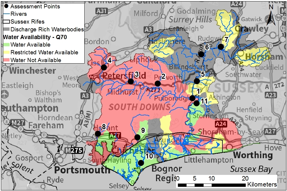
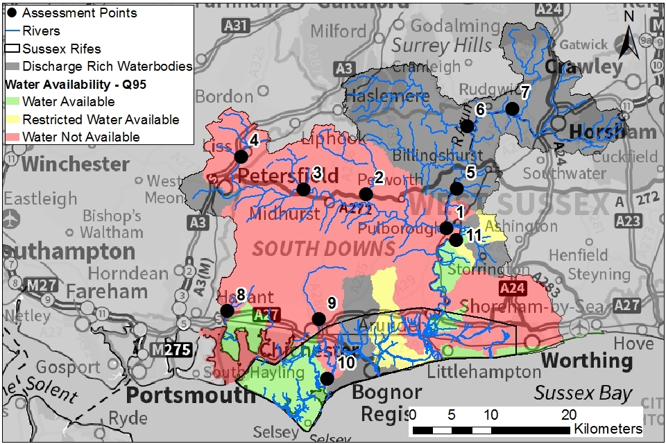
| 1 | Lower Rother | Available | Restricted | Not available | Not available |
| 2 | River Lod | Available | Restricted | Not available | Not available |
| 3 | Upper Rother | Available | Restricted | Not available | Not available |
| 4 | Princes Marsh gauging station | Available | Restricted | Not available | Not available |
| 5 | Pallingham gauging station | Discharge rich | Discharge rich | Discharge rich | Discharge rich |
| 6 | Drungewick gauging station | Discharge rich | Discharge rich | Discharge rich | Discharge rich |
| 7 | Alfoldean gauging station | Discharge rich | Discharge rich | Discharge rich | Discharge rich |
| 8 | Ems Westbourne | Restricted | Not available | Not available | Not available |
| 9 | Lavant Graylingwell | Not available | Not available | Not available | Not available |
| 10 | Pagham Rife | Available | Available | Available | Not available |
| 11 | Arun Total (Tidal) | Discharge rich | Discharge rich | Discharge rich | Discharge rich |
Note: water availability status given in this table is at AP level. Water availability may be different at a local level.
The River Arun and Pagham Rife are discharge rich. This is because large discharges from sewage treatment works increase river flows above those that would naturally be present. The Environment Agency has no control over the continued operation of discharges and so cannot guarantee reliability. You will need to contact the Solent and South Downs Integrated Environment Planning Team to find out more about any specific scheme.
Map 3: water resource availability colours at Q30 for Arun and Western Streams ALS
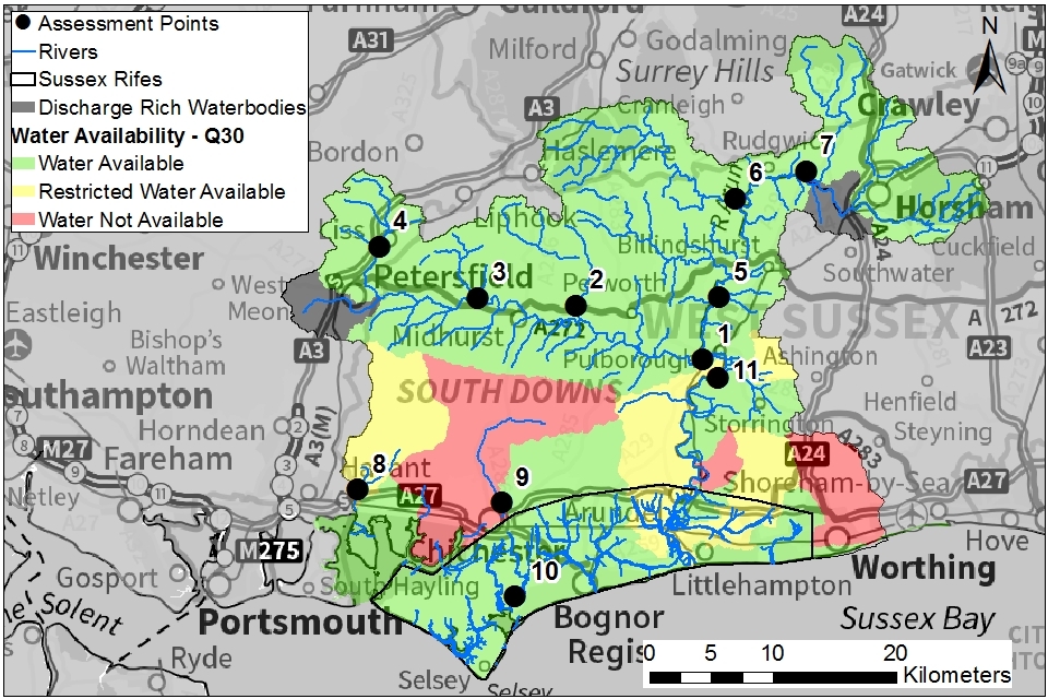
© Environment Agency copyright
Map 4: water resource availability colours at Q50 for Arun and Western Streams ALS
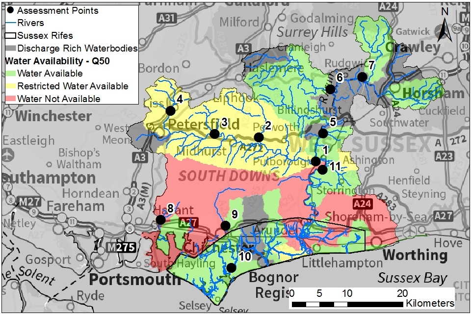
© Environment Agency copyright
Map 5: water resource availability colours at Q70 for Arun and Western Streams ALS
© Environment Agency copyright
Map 6: water resource availability colours at Q95 for Arun and Western Streams ALS
© Environment Agency copyright
3.2 Groundwater resource availability
Groundwater resource availability is a measure of how much groundwater is available for abstraction, after environmental requirements have been met.
Links to surface water and wetlands
Abstracting groundwater can impact on overlying surface water bodies. This impact is measured at the surface water AP. We cannot grant new groundwater licences where abstraction is reducing flows to below the indicative flow requirement to help support a healthy ecology. This is based on Q95 flows. Abstracting groundwater can also have an impact on springs and wetlands which are not related to APs. Where ecological impacts are possible, further detailed assessments are likely to be needed.
WFD Groundwater bodies
There are 8 WFD groundwater bodies in the Arun and Western Streams area:
- 5 are defined as principal aquifers where we have abstraction licensing policies
- 3 of these are secondary aquifers where there is only limited use of groundwater
We must account for the tests used to determine WFD groundwater body status by considering the:
- available resource in the aquifer
- impact of abstraction on protected sites including wetlands
- risk of saline intrusion
Groundwater management units
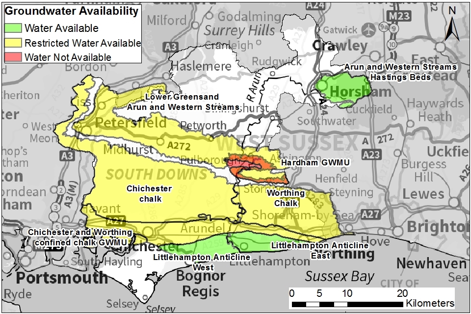
For major aquifers we may further divide the area into groundwater management units (GWMU), which are sub-divisions of the groundwater bodies. In these cases we use the information and assessments on these units to determine water availability and licence restrictions.
Hardham GWMU
We have defined a specific GWMU for the Hardham Basin. This is because there are significant abstraction pressures in this area which could affect the sensitive habitats of the Arun Valley. The Hardham GWMU includes the area of the Hardham Basin where the Folkestone Beds aquifer is at the surface. It also includes the area where the Folkestone Beds are buried by overlying deposits.
Chichester and Worthing confined Chalk GWMU
The Chalk aquifer goes underneath less permeable deposits in a strip across the coastal plain, coming back to the surface around Littlehampton. Despite being buried, the aquifer in this area can still yield significant quantities of water. It is widely used for public water supplies and to supply farmers and growers. This confined Chalk GWMU is not shown on maps as being part of the Chichester or Worthing Chalk WFD groundwater bodies. However, it is well connected to those units and abstractions can have an impact on those groundwater bodies. Abstraction from the confined Chalk can also have an effect on watercourses and water features that flow across the unconfined Chalk.
Groundwater resource availability colours and implications for licensing
We use colours to represent different groundwater availability:
Water available for licensing
Green
Groundwater unit balance shows groundwater available for licensing. New licences can be considered depending on impacts on other abstractors, designated ecological sites and on surface water.
Restricted water available for licensing
Yellow
Groundwater unit balance shows more water is licensed than the amount available. But the actual situation is sustainable because either:
- recent actual abstractions are lower than the amount available
- management options are in place to deal with the known impacts
In restricted groundwater units no new consumptive licences will be granted. We may also investigate the possibilities for reducing fully licensed risks. Water may be available if you can ‘buy’ (known as licence trading) the entitlement to abstract water from an existing licence holder.
In other units there may be restrictions in some areas, for example in relation to saline intrusion.
Water not available for licensing
Red
Groundwater unit balance shows more water has been abstracted based on recent amounts than the amount available. We will not grant further licences.
Groundwater availability maps
Map 7: groundwater availability in Arun and Western Streams catchment
© Environment Agency copyright
3.3 Resource reliability
If you want to apply for a licence, it’s worth considering the reliability of your surface water abstraction. By assessing the quantity of water available at different flows it’s possible to see:
- when there is a surplus or deficit of water
- the associated reliability of an abstraction
This is an indication only. Actual reliability of a licence will be discussed when you apply.
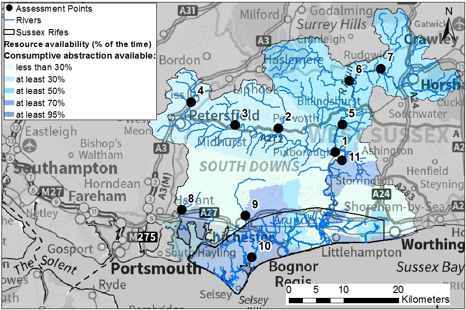
Map 8 gives an indication of the resource availability for consumptive abstraction in Arun and Western Streams catchment expressed as a percentage of time.
In this catchment there is the following water resource availability for consumptive abstraction at each AP:
- AP1: Lower Rother - at least 30% of the time
- AP2: River Lod - at least 30% of the time
- AP3: Upper Rother - at least 30% of the time
- AP4: Princes Marsh gauging station - at least 30% of the time
- AP5: Pallingham gauging station - at least 50% of the time
- AP6: Drungewick gauging station - at least 50% of the time
- AP7: Alfoldean gauging station - at least 50% of the time
- AP8: Ems Westbourne - less than 30% of the time
- AP9: Lavant Graylingwell - less than 30% of the time
- AP10: Pagham Rife - at least 70% of the time
- AP11: Arun Total (Tidal) - at least 70% of the time
Map 8: water resource reliability of the Arun and Western Streams catchment expressed as percentage of time available
3.4 Other considerations for resource availability and reliability
We will add constraints to licences such as hands off flow (HoF) conditions to protect:
- the environment
- the rights of other abstractors
As a result, when we grant a licence, it does not mean that we guarantee a supply of water. These conditions specify that if the flow in the river drops below what’s needed to protect the environment, abstraction must reduce or stop. In dry years, restrictions are likely to apply more often. This will affect the reliability of supply. There is no guarantee that we will grant licences even where water is available for abstraction. This is because we have to determine each application on its own merits. Local factors may mean we’re either unable to grant a licence as applied for, or even at all.
3.5 Transfer licences and impoundments
Transfer licences and impoundment licences do not usually result in water being removed from the environment. Therefore, they may not be subject to the same restrictions as full abstraction licences. Transfer licences are typically used for environmental schemes and hydropower installations. Applications will be dealt with on a case-by-case basis. More information may be found on our water management pages.
3.6 Time limits
New licences within a catchment are usually given a common end date (CED), which allows them to be reviewed at the same time. The next CED for this ALS is 31 March 2028 and the subsequent one is 31 March 2040.
3.7 Water rights trading
A water rights trade is where a person sells all or part of their water right, as defined by their abstraction licence(s), to another person on a permanent or temporary basis. In the majority of cases a trade will involve a change in abstraction location and/or use. We will need to approve these through the issue or variation of abstraction licences.
In licensing trades, as with new abstraction licences, we need to make sure that we do not cause any deterioration in water body status. This is both:
- within the water body / bodies where the trade will take place
- to downstream water bodies
The potential for trading in water bodies is dependent on water resource availability colour. Sections 3.1 and 3.2 explain the potential for licence trading for surface water and groundwater licences. There are very limited options for trading up to full licensed quantities in the Arun and Western Streams catchment. This is because in many places we are taking action to reduce the risk of deterioration in water body status. There may be some opportunities to trade recent actual abstraction.
To find out more about licence trading please go to our water management pages on GOV.UK.
4. How we manage water availability in the Arun and Western Streams catchment
4.1 Surface water
We assess surface water flows at APs. These are significant points on a river, often where 2 major rivers join or at a gauging station. APs cover multiple surface water bodies.
Where groundwater abstractions directly impact on surface water flows, the impact is measured at the surface water AP. We have used a groundwater model to assess how much groundwater abstractions from the chalk affect flows at APs on the:
- River Ems
- River Lavant
- Pagham Rife
- Upper Rother
Groundwater abstractions from the Lower Greensand can affect flows in the River Rother and Lower Arun.
Table 2 gives an indication of:
- how much water is available for further abstraction
- the associated restrictions we may have to apply to new and varied abstraction licences from the main river
Depending on the nature of the catchment, tributaries to the main river may be subject to different restrictions and quantities. This may be assessed locally on a case-by-case basis.
Each HoF is linked to an AP and is dependent on the resource availability at that AP. In some cases additional restrictions may apply to licences where there is a more critical AP resource availability downstream. This protects the ecological requirements of the river and other water users. This is detailed in the last column of table 2 if applicable.
All abstraction licence applications are subject to an assessment. This takes account of any local and downstream issues. It may be subject to further restrictions.
Reading from top to bottom in table 2 are the APs in the Arun and Western Streams catchment. Reading across the columns you can see:
- the potential HoF that may be applied to a licence
- the number of days water may be available under this restriction
- the approximate volume of water in Ml/d that may be available
In cases where there is water available at all flows we may apply a Minimum Residual Flow (MRF) to protect very low flows. We’ll decide this on a case-by-case basis.
In some cases it may be more appropriate to have a local hands off level control. Alternatively, abstraction may be regulated by using a specially designed structure. This structure would only allows abstraction when levels are high enough.
Table 2: summary of licensing approach for the assessment points of Arun and Western Streams ALS
| AP | Name | AP National Grid Reference | Water resource availability | HOF Restriction (Ml/d) | Number of days per annum abstraction may be available | Approximate volume available at restriction (Ml/d) | Is there a gauging station at this AP? | Additional restrictions |
|---|---|---|---|---|---|---|---|---|
| 1 | Lower Rother | TQ0341017909 | No water available | 280 | 135 | 29 | Yes | |
| 2 | River Lod | SU9312422257 | No water available | 28 | 135 | 12 | Yes | |
| 3 | Upper Rother | SU8522522909 | No water available | 178 | 135 | 29 | Yes | |
| 4 | Princes Marsh gauging station | SU7724727057 | No water available | 34 | 135 | 10 | Yes | |
| 5 | Pallingham gauging station | TQ0471322927 | No water available | 53 | 245 | 15 | Yes | Discharge rich |
| 6 | Drungewick gauging station | TQ0601030926 | No water available | 10 | 245 | 8 | Yes | Discharge rich |
| 7 | Alfoldean gauging station | TQ1173633131 | No water available | 31 | 245 | 8 | Yes | Discharge rich |
| 8 | Ems Westbourne | SU7550807393 | No water available | 28 | 135 | 2 | Yes | Protected area downstream at Chichester Harbour |
| 9 | Lavant Graylingwell | SU8711206336 | No water available | 20 | 73 | 1 | Yes | Protected area downstream at Chichester Harbour |
| 10 | Pagham Rife | SZ8823798768 | No water available | 5 | 288 | 0.4 | No | Protected Area downstream at Pagham Harbour |
| 11 | Arun Total (Tidal) | TQ0466116424 | Restricted water available for licensing | 195 | 245 | 15 | No |
4.2 Groundwater
WFD groundwater bodies
There are 8 WFD groundwater bodies in the Arun and Western Streams area:
- 5 are for principal aquifers
- 3 are for secondary aquifers
General licensing policies for groundwater abstractions
Where groundwater abstractions could impact on surface water or wetlands, the nature of that impact will have to be assessed. Depending on the scale of impact, we may not be able to issue a licence or restrictions may have to be applied to the licence.
Other restrictions may apply where availability is limited or to protect the environment, for example to:
- protect a designated site
- prevent saline intrusion
- prevent deterioration of a groundwater body
It is likely that you will need to provide extra information to support an application for a new or varied groundwater licence. This may include testing any borehole and monitoring the effects of abstraction. It could involve technical assessment to predict the impact of your proposal on other abstractors and the environment.
Licence restrictions on groundwater abstractions from principal aquifers in the Arun and Western Streams ALS area
Licence restrictions for the Chichester Chalk:
- restricted water available
- groundwater body is at poor quantitative status
- in some areas of this groundwater body, abstraction is not sustainable and action is being taken to reduce existing abstraction licences
- no new consumptive licences will be granted
Licence restrictions for the Worthing Chalk:
- restricted water available
- groundwater body is at poor quantitative status
- the aquifer is adjacent to the sea at Worthing and tidal River Arun near Arundel and could be at risk of saline intrusion
- no new consumptive licences will be granted
Licence restrictions for the Chichester and Worthing confined Chalk GWMU:
- restricted water available
- there is no defined WFD groundwater body which includes the confined Chalk
- the confined Chalk is linked to the Chichester and Worthing Chalk, and so we have assigned the same status to this GWMU
- it is unlikely that any new consumptive licences will be granted
Licence restrictions for the Lower Greensand Arun and Western Streams:
- restricted water available
- groundwater body is at Good Quantitative Status
- much of this aquifer supports flow in the Western Rother which is classed as restricted water available
- further groundwater abstraction could reduce flows in the Rother and so no new consumptive licences will be granted
Licence restrictions for the Hardham GWMU:
- no water available
- this GWMU is part of the WFD groundwater unit for Lower Greensand and Western Streams but has been defined as a specific unit
- action is being taken to investigate and potentially reduce existing abstraction licences
- no new consumptive licences will be granted
Licence restrictions for the Littlehampton Anticline East and West:
- water available for licensing
- groundwater body is at good quantitative status for both units
- units are made up of low lying coastal Chalk
- groundwater resources in this area are likely to be limited and water quality may be naturally poor
- there is likely to be a risk of saline intrusion for abstractions near the coast
- new licences can be considered depending on impacts on other abstractors and on surface water and in relation to risk of saline intrusion
Licence restrictions on groundwater abstractions from secondary aquifers in the Arun and Western Streams ALS area
Licence restrictions for Arun and Western Streams Hastings Beds, Sussex Lambeth group, South East Hants Bracklesham group:
- water available for licensing
- groundwater bodies are all at good quantitative status
- new licences can be considered depending on impacts on other abstractors and on surface water and other water features
- no specific policy for these secondary aquifers - these aquifers are highly complex due to faulting and geological variability and there is limited information on outflows and water levels.
- these aquifers only yield comparatively small volumes of water, although it is noted that these can be locally important
4.3 Sussex ‘rifes’ surface water abstraction policy
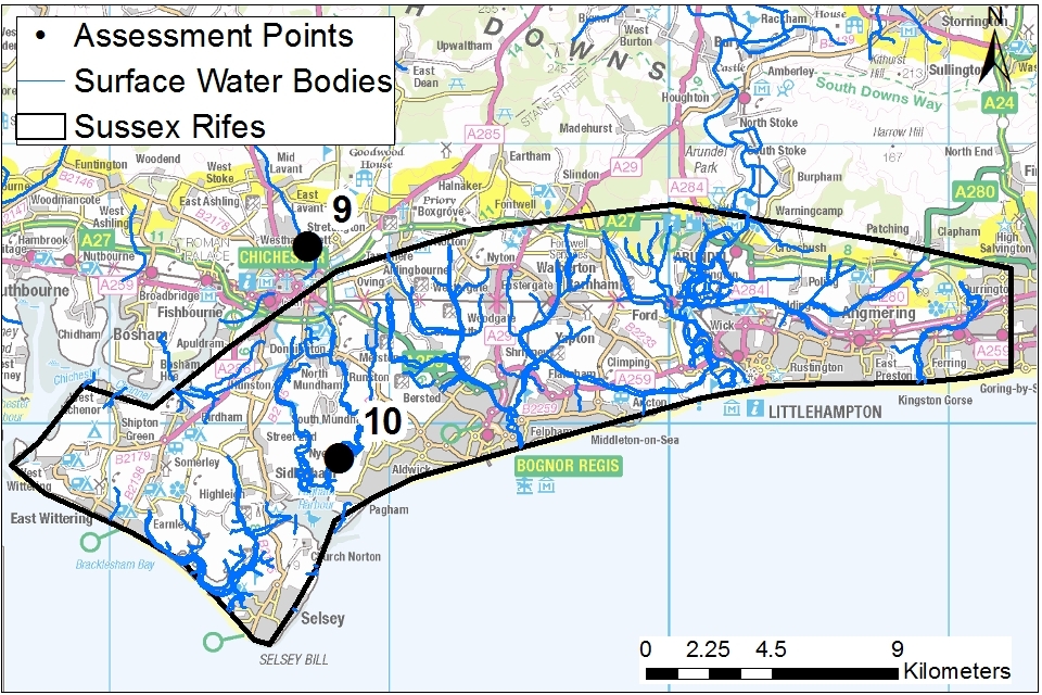
The rifes are a collection of relatively small streams flowing across the Chichester Plain between Chichester and Arundel. Most do not have sufficient monitoring on them to define APs, except the Pagham Rife.
Map 9: location of coastal rifes in the Arun and Western Streams catchment
© Environment Agency copyright
The rifes covered by this policy include the watercourse shown in map 9. The main watercourses are:
- Earnley Rife
- Grange Rife
- Easton Rife
- Keynor Rife
- Broad Rife
- Bremere Rife
- Elbridge Rife
- Forebridge Rife
- Aldingbourne Rife
- Lidsey Rife
- Barnham Rife
- Binsted Rife
- Bilsham Ditch
- Black Ditch
- Ferring Rife
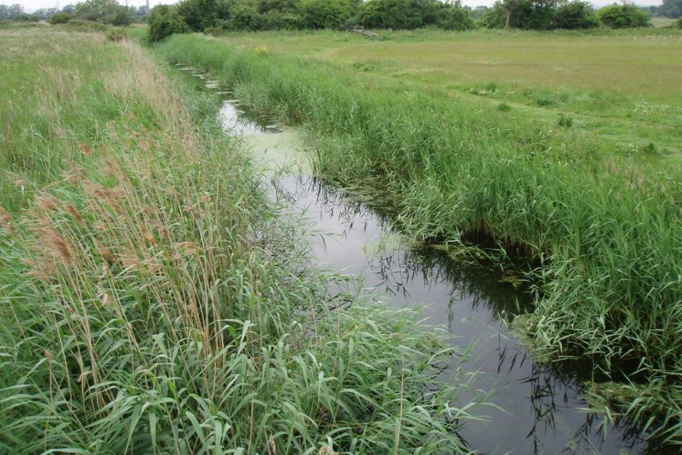
The photograph shows the Aldingbourne Rife flowing through agricultural fields. Like many of the rifes, the channel is narrow and deep with slow flowing water.
The headwaters of some of the rifes are fed by Chalk groundwater but they also gain flow from water stored in local sands and gravels. Many rifes have been widened, deepened and straightened. Where they flow into the sea most have outfalls and sluices protecting the rifes from seawater inundation. There is often a tidal impact caused by the backing-up of flow during each high tide. In various locations stop-boards have been installed to maintain water levels, though mostly in the summer months.
The downstream ends of many of the rifes are therefore more level dependent than flow dependent. This section outlines the separate policy we use to assess applications in this area. In summary the policy states:
- no new unconstrained licences will be granted
- there is a presumption against new consumptive surface water abstractions during the summer (April to October)
- winter abstraction licences, including those which involve storage of water and subsequent summer use, will be granted for direct river abstraction between November and March
- all surface water abstractions will be issued with a hands off level (HoL) or HoF which will as a minimum protect flows below the winter Q90 (or equivalent annual Q70)
- flooding from some rifes contributes to valuable wetland habitats, and the range of levels and flows in the rifes should be protected in addition to protecting low flows
More stringent conditions may be required where a rife flows into important conservation sites such as Pagham Harbour. The freshwater requirements of those conservation sites will need to be considered in combination with the rifes policy.
Additional permits may be required for any structures to facilitate abstraction. These would need to have a minimal impact on bankside habitat to ensure protection of water voles.
4.4 Coasts and estuaries
Tidal River Arun
The tidal limit of the River Arun is approximately 26km inland. Below the river’s tidal limit the Arun is joined by:
- River Stor
- River Chilt
- Western Rother (it’s largest tributary)
While the tidal Arun does not flow into any designated site, the impact of abstraction on freshwater flows must always be considered.
Chichester and Pagham Harbours
Many of the watercourses of the Chichester coastal plain flow into the international designated sites of Chichester Harbour and Pagham Harbour. Freshwater flows into Chichester Harbour arise from:
- Chichester Rifes
- River Lavant
- River Ems
- Fishbourne Springs
- Bosham Stream
- Cutmill Creek
- Ham Brook
- springs at Warblington
Pagham Harbour receives 3 discrete inputs of fresh water from the Pagham, Broad and Bremere rifes.
4.5 Protected sites
The Conservation of Habitats and Species Regulations 2017 (Habitats Regulations) provides a very high level of protection to 2 types of designated sites due to their special environment. These are:
- Special Areas of Conservation (SAC), which contribute to biodiversity by maintaining and restoring habitats and species
- Special Protection Area (SPA), which provides protection to birds and their nests, eggs and habitats
Government policy treats Ramsar sites (internationally important wetland sites) in the same way as SACs and SPAs. Ramsars, SACs and SPAs are referred to collectively as European sites. In the Arun and Western Streams catchment area it is particularly important to consider the impact of any abstraction on the following water related protected areas:
- Arun Valley (including Pulborough Brooks, Waltham Brooks and Amberley Wild Brooks)
- Pagham Harbour
- Chichester and Langstone Harbours
- Solent Maritime
Other protected areas may also have to be considered. For example, those where bats make use of wetland areas away from the actual designated site.
Sites of Special Scientific Interest (SSSI) also carry a high level of environmental importance. In the Arun and Western Streams catchment area the following SSSIs are particularly important when considering abstraction licence impacts:
- Arundel Park (including Swanbourne Lake)
- Upper Arun
- Arun Banks
Conservation objectives are the main objectives for European and SSSI protected sites to maintain at, or to reach, favourable condition. These are set by Natural England. The process for setting targets is described through the Joint Nature Conservation Committee approved Common Standards Monitoring guidance (CSM). Natural England use these targets to assess the condition of European and SSSI protected sites. These quantitative targets are considered by Natural England as a pre-requisite for achieving the conservation objectives for European or SSSI designated sites. We have a duty to have regard to Natural England’s advice when determining licence applications that may impact on a designated site.
We may need more detailed supporting information when a licence application could impact on a designated conservation site. This will allow us to complete the required statutory assessment.
5. Managing the catchment together
5.1 General action on unsustainable abstraction
Managing water abstraction gives details on:
- what an unsustainable abstraction is
- the measures available to resolve environmental issues caused by abstraction
We have been taking action to address unsustainable abstraction and to protect the water environment across the Arun and Western Streams catchment. We do this by working with licence holders to modify abstraction licences. We also put in place measures to improve the environment and build ecological resilience.
Water company actions
Every 5 years, the Water Industry National Environment Programme (WINEP) sets out the requirements on water companies to address unsustainable abstraction. In the Arun and Western Streams catchment, this process has resulted in licence changes to protect designated sites. It has also resulted in habitat improvement work on the River Ems.
The WINEP process is changing to become more collaborative with a wider scope to deliver multiple benefits for catchments. This new process will be used for the next 5 year period 2025 to 2030.
Managing time limited licence renewals
We manage time limited licence renewals to ensure abstraction is not having a negative impact on the environment now or in the future. Most current time limited licences in the Arun and Western Streams catchment expire on 31 March 2028. Five time limited licences expire before that date.
A time limited licence will be renewed on the basis that:
- it is sustainable
- there is continued justification of need
- the water is used efficiently
If there is information to suggest that a licence is no longer sustainable, we may put more restrictive conditions on it or reduce it.
Any time limited licences which could have an impact on the designated sites of the Arun Valley are likely to require:
- further assessment
- supporting information to be submitted
Further detail on renewing a time limited licence can be found on the renewing a water abstraction licence pages .
Modernising the Abstraction Licensing Service
We have developed a Water Resources Licensing Service (WRLS) that allows water abstraction licence holders to manage their licences online. The service allows licence holders to:
- view their licences
- delegate access to their account
- submit information about how much water they have taken
From April 2022, some licence holders will receive Water Abstraction e-Alerts via the service. The e-Alerts will provide quicker targeted warnings of approaching HoF restrictions. The alerts will inform licence holders and operators when restrictions have taken effect. They will also enable us to advise when abstraction can resume following recovery of river flows or groundwater levels. It is similar to our Flood Warning Service, but considers water management during periods of dry weather.
The e-Alerts will help:
- improve access to water when it is there
- better protect the environment when it is not
- demonstrate how we are supporting abstractors to adapt to climate change
Industry data has been used to calculate a potential annual benefit of £13.7 million to the economy and society from improving access to water resources.
National Framework
We have worked with stakeholders, regulators and government to develop a Water Resources National Framework. This explores the long-term needs of all sectors that depend on a secure supply of water. The strategy sets out:
- the scale of action needed to ensure resilient water supplies are available to meet the needs of all users in the future
- a greater level of ambition for restoring, protecting and improving the environment
The framework establishes the concept of an environment destination. We will work collaboratively to move towards an improved and more resilient water environment. In the Arun and Western Streams catchment, resolving abstraction issues in the Arun Valley and the River Ems are a high priority. Other priorities include better protection for small chalk streams such as Bosham Stream and the River Lavant.
Chalk stream restoration strategy
This area has several chalk streams like the River Ems, Lavant and Bosham Stream. A Chalk Stream Strategy on the future of chalk streams has been published by the Chalk Stream Restoration Group. Developed in collaboration it sets out that no single organisation can improve chalk streams alone. The future of our chalk streams is dependent on actions by water companies, farmers, landowners and individuals.
Water neutrality
Natural England has stated that ongoing groundwater abstraction for public water supply is likely to be having a detrimental impact on a number of designated sites. These include Amberley Wild Brooks SSSI and Pulborough Brooks SSSI. These form part of:
- Arun Valley SPA
- Arun Valley SAC
- Arun Valley Ramsar site
We agree that there is a potential risk to these designated sites from groundwater abstraction. Southern Water are leading a programme of work to investigate the impacts of their abstraction. This is in collaboration with ourselves, Natural England and other stakeholders. The investigation will collate evidence to determine the appropriate conditions for a more sustainable abstraction licence. This investigation work is essential to work towards preventing any further deterioration. It will also contribute towards restoring the sites to more naturalised conditions.
Natural England have published a water neutrality advice note. They explain that water neutrality has been proposed as one of the means of avoiding an adverse effect on integrity of the designated sites. Further information about what water neutrality is and where it applies can be found here:
- Water resources in Northern Chichester District: Chichester District Council
- Water neutrality in Horsham District: Horsham District Council
Potential applicants for an abstraction licence in areas affected by water neutrality restrictions will need to consider the policies set out in this abstraction licensing strategy.
5.2 Specific action on unsustainable abstraction
Hardham Basin GWMU
The water resource availability colour for the Lower Greensand groundwater body that Hardham GWMU sits in is yellow. The status of Hardham GWMU is red because there is concern that large groundwater abstractions in the Hardham basin exceed the sustainable limit for abstraction. There is also concern that abstraction could potentially be impacting on the designated sites within the Arun Valley (SAC, SPA, SSSIs and Ramsar site).
Action that we will take on unsustainable abstraction
We will take the following action to more sustainably manage abstraction in this catchment:
- in 2022 we will review a variation of Southern Water’s groundwater licence to set it on a pathway to becoming a sustainable abstraction licence
- until April 2025, we will continue to work with Southern Water, Natural England and others on a sustainability investigation to determine how abstraction licences need to change in the future to ensure that the designated sites are protected
- we will encourage Southern Water to minimise use of their groundwater source whilst the investigation is being carried out
- time limited licences may be subject to more restrictive renewal
- our policy on unused and underused licences is to continue to pursue reduction or revocation of licences where there is no longer a justifiable need for them
Chichester Chalk
The water resource availability colour is yellow and WFD quantitative status is poor. This is due to the effect of groundwater abstraction on dependent surface water bodies such as the River Ems.
Action that has been taken on unsustainable abstraction
We have taken the following action to reduce abstraction and achieve objectives in this catchment:
- water company groundwater licences have been reduced to the west of Arundel to protect Swanbourne Lake
- water company groundwater licences have been reduced to protect freshwater inflows to the designated site of Chichester Harbour
- restrictions were placed on a water company licence to the west of Chichester to protect the habitat of the Desmoulins Whorl Snail in Fishbourne creek
- 9 new authorisation applications have been determined for trickle irrigation abstractions from the Chichester Chalk in 2022
Action that we will take on unsustainable abstraction
We will take the following action to reduce abstraction in this catchment:
- time limited licences may be subject to more restrictive renewal
- our policy on unused and underused licences is to continue to pursue reduction or revocation of licences where there is no longer a justifiable need for them
River Ems
The water resource availability colour is red, therefore flows do not support good ecology and the environment could be damaged as a result. Abstraction for public water supply has the most significant effect on flows in the River Ems. There are no surface water abstractions from the River Ems and only a few small agricultural groundwater abstractions.
Action that has been taken on unsustainable abstraction
We have taken the following action to reduce abstraction and achieve objectives in this catchment:
- we have been involved in projects working in partnership with others to improve habitat and fish passage
- in 2016, one public water supply abstraction licence was varied to stop abstraction for public water supply and instead provide water for a new augmentation scheme
Action that we will take on unsustainable abstraction
We want the River Ems to be a thriving, diverse ecosystem and are keen to work with others to achieve this. Abstraction management is a key factor and we expect that changes will be made to Portsmouth Water’s abstraction licences. The nature and timing of these changes will have to take into account the need for safe, secure and sustainable public water supplies. We anticipate that any changes will be made in 2 phases.
Phase 1 will amend the licences to reflect any revised arrangements for augmenting the river. In 2020, it became apparent that the new augmentation scheme was not effective at preventing very low flows. We are working with Portsmouth Water and others to gather new evidence to help shape a more effective way of supporting the river during low flows.
We expect a second phase of licence changes will be needed to meet our environmental ambition for chalk streams.
In 2022 Portsmouth Water started scoping a 10-year Chalk Stream Restoration Plan for the River Ems. The project reflects increasing government pressure for the water industry to work with:
- communities
- regulators
- wider organisations
Sustainable options are needed for chalk fed river catchments under threat of over abstraction and further challenged by enhanced climate change. We look forward to working with others on this project.
5.3 Approaches to sustainable water management
This section outlines options initiated in this catchment for future approaches to water management, including collaboration and sharing. These may be of interest to both new and existing abstractors. Through the priority catchment project we have been working with abstractors to highlight unsustainable abstraction. We want to encourage collaboration between stakeholders to find novel and innovative ways to access water sustainably.
Exploring the effects of climate change in the Rother Valley
Climate change can impact water resources by affecting the amount of water that is available in the environment and the demand for water. It is important to understand what those changes might mean for our area. This should ensure that there are resilient water supplies for the future and protect the environment under a changing climate.
Estimates of climate change for the whole Arun and Western Streams catchment were given in section 2.3. Researchers at the University of Leeds have been considering in detail how climate change may affect flows in the Western Rother. They have looked at 18 different combinations of models to predict river flows in the:
- 2020 to 30s
- 2040 to 50s
- 2060 to 70s
The modelling shows that the strongest impacts of climate change are predicted for winter streamflow, which may increase by as much as 25 to 35%. Some decreases in flow are projected for the summer months but these are not expected to cause flows to reduce by more than 10%. Temperature is also projected to significantly increase. Details on the project can be found on the project overview webpage hosted by Leeds University.
Recent events have shown that climate change can also be linked to more extreme weather events affecting our daily weather patterns. We are more likely to experience extended hot dry spells as well as more intense rainfall events. These changes are likely to affect the amount of water needed for irrigation. They could also affect the type of crops that are grown in the catchment. More intense rainfall events could also pose additional risks for flooding and soil erosion.
An indication of possible effects of climate change is important. It enables us to work with abstractors to develop water supplies that are resilient for the future. A good example of this are high flow storage reservoirs. These can be designed to potentially provide flood risk benefits as well as opportunities for enhancing biodiversity.
Building resilient water supplies
An important aspect of our work has been to:
- learn more about the needs of a variety of water users
- consider how to build resilient and sustainable water supplies for the future
The main non public water supply water uses in the catchment are:
- hydropower schemes
- irrigation of field crops in the Rother Valley
- irrigation of intensively cropped glasshouses on the Chichester coastal plain
- irrigation of water for leisure sector
- water supply for general agriculture and farming
We visited licence holders across all of these sectors to find out more about the good practices already taking place and to understand future challenges. We chose not to set up a new group to look specifically at water resources but to work with existing groups.
Water Resources South East (WRSE) has been tasked with:
- planning the region’s water supplies
- developing the necessary schemes needed to supply water to people, businesses and the environment
The group has a multi-sector team considering how the future water needs of businesses can be met. It is looking for opportunities to develop water resources which can benefit multiple sectors. We have worked with this group to provide the local information from the Arun and Western Streams catchment to inform region wide planning. We have also looked to see if any of the work of WRSE can be transferred back to this local area.
Environment Agency involvement in local and regional groups looking at water needs across sectors will help make a variety of options more accessible for water users.
We have considered a variety of options that we would like to promote further.
Encouraging development of storage reservoirs
If planned and managed correctly, storage reservoirs can provide significant benefits to water users and the environment by:
- increasing water security
- enabling higher yields to be obtained from crops
- taking water from the environment at a time when it is more readily available
- providing biodiversity benefits
- potentially reducing flood risk
In water bodies where there is restricted or no water available, high flow abstractions may be the only option for abstracting water. A high flow abstraction combined with a storage reservoir can provide an effective and reliable water resource. The recent Farming Transformation Fund allowed application for grants to support larger investments like storage reservoirs.
We expect there to be further grant schemes in the future to provide incentives to develop storage schemes. Where it’s possible, we will encourage the development of storage reservoirs filled during times of high flow. Potential applicants are encouraged to discuss schemes with us at an early stage.
All year high-flow abstraction
Many water users with storage reservoirs are permitted to abstract only during the period January to March. November and December have sometimes been included. As the climate changes, rainfall patterns are changing and there is the potential for more high flows at all times of year. We will now consider applications to fill storage reservoirs throughout the year during periods of high flows or levels.
We will keep this new approach under review. Our permitting decisions will continue to recognise the valuable role that high flows play in the water environment. They will take account of local environmental sensitivities.
There is no guarantee that every application will be successful. Depending on the details of a proposal there may also be an increase in water abstraction charges.
Rainwater Harvesting
Many glasshouses in the Arun and Western Streams catchment already store and then use rainwater collected from the roofs of the glasshouses. This is often an effective and efficient use of water and may help the development of more resilient and sustainable water supplies. More details about our licensing policies for rainwater harvesting can be found in our rainwater harvesting regulatory position statement.
Changes to land management to improve soil health
The Arun and Western Streams catchment partnership is involved in projects to reduce soil erosion and improve water quality in the Western Rother. We want to engage with this work to explore the water resource benefits that may be possible. Improving soil health will improve moisture retention and should reduce irrigation need.
Leisure Association Water Charter
In the Arun and Western Streams catchment the leisure sector can be significant users of both mains and non-mains water. Their need for water is often during the driest conditions when water is used to irrigate facilities such as:
- golf courses
- football pitches
- polo pitches
- race courses
The Leisure Association Water Charter introduces the ambition for the leisure sector to move towards more sustainable water supplies. This water sector funded initiative was developed by:
- Environmental Solutions International
- leisure associations
- leisure operators
- the English and Welsh water companies
It is also supported by Waterwise - the water efficiency charity. It introduces the concept of abstractors developing a water resilience plan. Another important aspect is the need to work with others to develop water resource schemes with multiple benefits such as:
- reducing run off to minimise flood risk
- enhancing the natural environment
- providing community benefits
Agricultural water resources advice visits
The Environment Agency and Natural England’s Catchment Sensitive Farming (CSF) officers have trialled new water resources advice visits. These have included 8 sites in the Arun and Western Streams area. These included visits to individual farmers as well as to larger agri-businesses and glasshouse operators. The data from the visits is treated as confidential. The advisors have helped farmers to understand how to improve water efficiency and grow more.
The most common recommendations were:
- improve water retention by improving soil structure
- harvest rainwater for crop protection sprayer filling
- install/improve equipment to improve irrigation application efficiency
- investigate alternative sources of supply such as rainwater harvesting, installing a borehole or building additional reservoir storage
- manage irrigation using the D-risk tool
- irrigation at night rather than daytime
Overall, the farmers visited rated the advice as excellent (81%) and good (19%). The findings from these visits will be used to develop the water advice visits so that they can be offered to more abstractors. Our hope is that the best practice outputs from these visits will be shared more widely to drive best practice in water management. Any farmer seeking advice from CSF must complete a request that is emailed to the relevant River Basin District. More information can be found on the catchment sensitive farming pages.
Working with natural processes
The Environment Agency and JBA consulting have produced a new Working with natural processes study. The study maps the best locations to work with natural processes to improve resilience to drought and floods. The maps identify areas where there is potential for measures to be developed. In combination with catchment walkovers, local knowledge and discussions with landowners these maps and information can identify opportunities for further work. By working with natural processes, the land can be managed in different ways to improve the way it holds back and stores water.
Measures include:
- improving soil and land management techniques
- installing attenuation features
- re-naturalising channels
- rewilding
- wetland creation
In the Arun and Western Streams catchment, the study focused on 2 contrasting areas – the upper reaches of the Western Rother and the River Ems. The study identified potential to increase recharge to the greensand in the Rother Valley. This was by implementing improved land management techniques such as cover crops and minimum tillage.
Case studies in other catchments
More information on work in other catchments can be found in the updated ALS for:
6. Related links
-
Agriculture and Horticulture Development Board (AHDB) website - provides information on effective use of water on livestock farms
-
Catchment Based Approach community website - provides further information on the catchment based approach
-
UK Centre for Ecology and Hydrology Drought Portal - is an interactive portal presenting information on the laterst hydrological situation across the UK
-
Environment Agency, how to apply for a water abstraction or impoundment licence web pages - provide all the information needed to go through the application process to get a licence
-
Environment Agency manage your water abstraction or impoundment licence online web service - allows abstractors to view and share licence information and submit abstraction returns
-
Environment Agency priority catchments website - provides further information about the priority catchment work
-
The Environment Agency National Framework for Water Resources -explores England’s long-term water needs and the importance of planning at the regional scale and link to the catchment scale
-
Linking Environment and Farming (LEAF) Simply Sustainable Water guide - explains 6 simple steps for managing water quality and use on your land
-
National Farmer’s Union web pages on Irrigation and water resources - provide useful information
-
Natural England’s website - provides further information on protected sites and species
-
Environment Agency and Cranfield University’s guide to planning, designing, constructing and commissioning a water storage reservoir - if you are considering an irrigation reservoir
-
The UK Irrigation Association and Cranfield University - provide a range of irrigation booklets that tackle key issues
-
Waste and Resources Action Programme website has guidance on water efficiency in the food and drink industry
-
Waste and Resources Action Programme website has a guide to water saving devices and practices
7. Glossary
Abstraction - removal of water from a source of supply (surface or groundwater).
Abstraction licence - the authorisation granted by the Environment Agency to allow the removal of water.
Assessment point - a significant point on a river, often where two major rivers join or at a gauging station.
Catchment - the area from which precipitation and groundwater will collect and contribute to the flow of a specific river.
Catchment based approach - partnership working at the river catchment scale to deliver a range of environmental, social and economic benefits while protecting our precious water environments for the benefit of all.
Consumptive abstraction - abstraction where a significant proportion of the water is not returned either directly or indirectly to the source of supply after use. For example for the use of spray irrigation.
Discharge - the release of substances (for example, water, treated sewage effluent) into surface waters.
Environmental Flow Indicator - flow indicator to prevent environmental deterioration of rivers, set in line with new UK standards set by UKTAG.
Groundwater - water that is contained in underground rocks.
Hands off flow - a condition attached to an abstraction licence which states that if flow (in the river) falls below the level specified on the licence, the abstractor will be required to reduce or stop the abstraction.
Impoundment - a structure that obstructs or impedes the flow of inland water, such as a dam, weir or other constructed works.
Rifes - small streams on the West Sussex coastal plain. They flow directly out to the coast and are often influenced by the tide.
Surface water - this is a general term used to describe all water features such as rivers, streams, springs, ponds and lakes.
Water body - units of either surface water or groundwater which we use to assess water availability.
8. Copyright - maps
© Environment Agency copyright and/or database right 2022. All rights reserved. This map includes data supplied under licence from: © Crown Copyright and database right 2022. All rights reserved. Ordnance Survey licence number 100024198.
9. Contact details for further information
For local water resources advice contact the Solent and South Downs Integrated Environment Planning Team. You can either call or email the team:
- call 03708 506 506 (calls cost no more than a national rate call to an 01 or 02 number)
- email enquiries@environment-agency.gov.uk