£1.2m innovation contracts awarded to help Army engineers survey water crossings
DASA announces five small and medium-sized businesses to develop semi-autonomous reconnaissance and survey systems
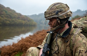
Picture showing Army personnel looking over a river crossing
The Defence and Security Accelerator (DASA) has awarded contracts worth a total £1.3m to develop semi-autonomous reconnaissance and survey systems to help troops safely and stealthily advance into enemy territory across water obstacles such as rivers.
Map the Gap, run on behalf of the Defence Science and Technology Laboratory (Dstl), sought ideas from industry and academia to create a new remote system capable of surveying potential crossing sites by gathering data about the river banks.
Colonel Simon Bradley, Assistant Head Manoeuvre Support, Ground Manoeuvre Capability British Army, said:
We are hugely excited by the benefits the Map the Gap project may realise.
The reconnaissance of multiple potential crossing sites at the forward edge of the battle exposes soldiers to significant risk. Replacing and/or augmenting manned reconnaissance with a remote, beyond line-of-sight system will not only reduce the threat to life; it will also offer the ability to survey multiple crossing sites in a far more timely and efficient manner.
In turn, this will provide greater choice to ground commanders and more opportunities to out-manoeuvre our opponents. It will be a force multiplier for our next generation bridging systems.
Five small and medium-sized businesses have been awarded Phase 1 funding to fast-track their innovative solutions and test with the British Army.
The organisations are:
-
Scytronix – whose proposal is for a drone mountable crossing assessment system that uses novel low frequency electromagnetic scanning techniques.
-
Wight Ocean – to develop an amphibious bottom crawler to navigate and transit water crossing to gather near real-time data for analysis.
-
Nordic Unmanned AS – to demonstrate unmanned aerial systems sensors, and data exploitation, and a semi-autonomous capability for engineer reconnaissance.
-
Digital Concepts Engineering – to develop an unmanned ground vehicle and drone ‘team’ with a variety of sensors to gather, aggregate and present data.
-
Foundry Cube in collaboration with Ultrabeam Hydrographic – to demonstrate an autonomous and amphibious hydrographic survey vehicle similar to a pedalo, using novel techniques tools and Sonar and Lidar (using laser light and measuring reflection).
The military need to be able to cross obstacles such as rivers, streams, bogs and other so-called ‘wet gaps’.
Currently, the only way of identifying suitable crossing points is to send Royal Engineer reconnaissance troops to survey both banks of the river – exposing them to danger which also risks compromising the operation by signalling interest in that location to the enemy.
Our vision is ultimately to remove personnel from these dangerous tasks with a remote system that allows more crossing locations to be surveyed, increasing the choices available to commanders and giving an opportunity to surprise the enemy.
An additional £2.5m is anticipated for further development in Phase 2.
Phase 1 funding:
- Scytronix – £251,900
- Wight Ocean – £309,282
- Nordic Unmanned AS – £272,656
- Digital Concepts Engineering – £331,133
- Foundry Cube – £177,789