Purfleet, Grays and Tilbury Policy Unit: Thames Estuary 2100
What needs to be done to manage flood risk and adapt to rising sea levels in Purfleet, Grays and Tilbury, one of 23 policy units in Thames Estuary 2100 (TE2100).
Applies to England
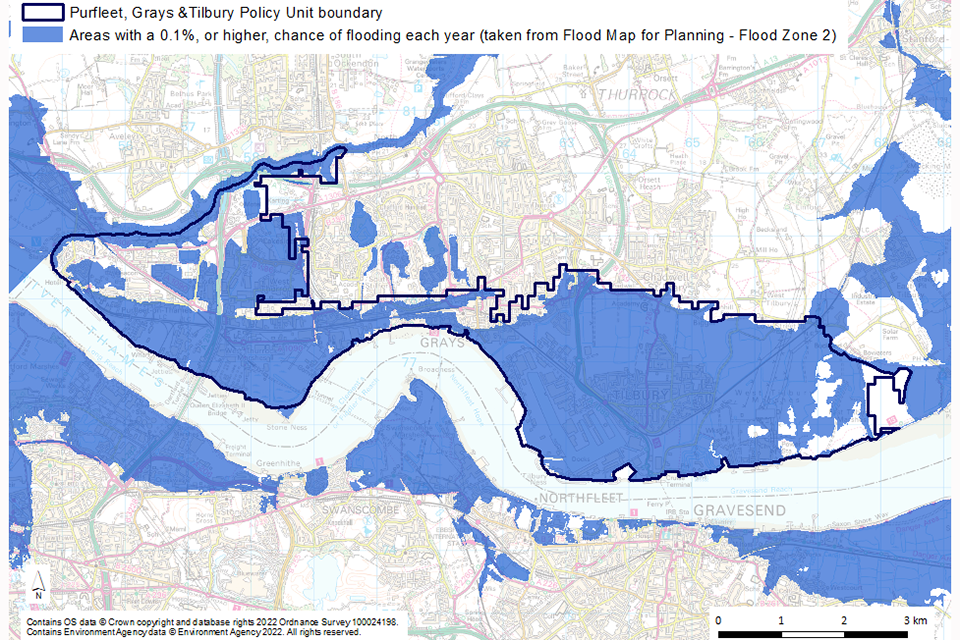
Map centred on the Purfleet, Grays and Tilbury policy unit boundary, which extends from Mardyke in the west, along the north bank of the River Thames to Tilbury Coalhouse Fort. The map extends 3 kilometres (km) north and south and 1km east and west. The flood risk layer shows that, in much of the policy unit, there is a 0.1% or higher chance of flooding each year without the existing flood defences. The risk is reduced by defences.
Description
Purfleet, Grays and Tilbury is a large policy unit that includes Tilbury Town and parts of the urban areas of Grays and Purfleet. This policy unit has 2 main floodplain areas at Tilbury and West Thurrock and Purfleet.
The council responsible for this area is Thurrock Council.
In this area the River Thames is joined by the Mardyke and there are local watercourses in West Thurrock Marshes and in West and East Tilbury Marshes.
The area is mostly industrial and commercial and includes:
- port facilities, such as the Port of Tilbury
- active riverside jetties and wharves
- the Dartford Tunnel
- HS1 railway northern tunnel portals
Use the Thames Estuary 2100 (TE2100) map to view all the policy units.
Local areas at risk and types of flooding
Most of the marsh areas are low lying, less than 1 metre above mean sea level, and some of the developed areas are very vulnerable to flooding.
The types of flooding that could affect this policy unit include:
- tidal flooding – when the tide overtops flood defences
- fluvial flooding from local watercourses – when heavy rainfall causes rivers to overflow
- surface water flooding – when heavy rainfall is unable to drain away
- a combination of these
Managing flood risk in this area
There are tidal flood defences along the Thames Estuary frontage and other local flood defences in Tilbury Town.
The Tilbury Dual Function Lock Gate (which replaced the Tilbury Barrier) can be closed to prevent flooding.
There are drainage system outfalls in the area, including at West Thurrock and West Tilbury marshes.
The Environment Agency also uses flood alerts and flood warnings to inform people about potential flooding so they can take appropriate action.
Sign up to receive flood warnings in your area.
Flood risk management policies for this area
Thames Estuary 2100 sets flood risk management policies for each area of the estuary. The policies range from P3 to P5 and outline how we should manage that area’s tidal defences.
In this area a P4 policy applies.
This means we will take further action to keep up with climate and land use change so that flood risk does not increase. We will need to work with other risk management authorities to do more to manage flood risk.
Find out more about flood risk management policies.
Local requirements: who needs to do what
Tidal flood defence owners
By 2040, tidal flood defence owners in this policy unit should:
- work with the council, developers and local infrastructure providers to adapt defences and achieve multiple benefits through proposed development
- work with the Environment Agency to raise defences where required
For further information read outcome 2: improving fixed flood defences.
Local councils
The Association of South Essex Local Authorities includes:
- Basildon
- Brentwood
- Castle Point
- Essex County
- Rochford
- Southend-on-Sea
- Thurrock
The Association will work with the Environment Agency to manage the risk of flood and create multiple benefits. This should be part of South Essex proposals, from strategic plans to landscape-scale environment schemes. It should also be in line with the riverside strategy approach.
There is currently no riverside strategy for this area. By 2030, councils should work with communities to plan how their riverside will look in future.
Find out more about the riverside strategy approach.
Network Rail
Network Rail will work with councils and the Environment Agency to ensure transport infrastructure in Essex is resilient to increasing flood risk. This will support growth in the outer estuary.
Thames Estuary Partnership
The Thames Estuary Partnership will work with communities, councils, the Environment Agency and other partners to:
- update the Thames Strategy East upstream of Tilbury
- scope the need and potential extension of the Thames Strategy East or creation of an alternative Joint Thames Strategy downstream of Tilbury
Any agreed landscape visions for the river corridor will include a riverside strategy approach to tidal flood defence upgrades.