Managing future flood risk and Thames Barrier: Thames Estuary 2100
How the Environment Agency and its partners will maintain and upgrade flood defences in the Thames Estuary to adapt to rising sea levels.
Applies to England
Over the coming decades, climate change will make average sea levels rise. High tides will be higher and storm tides bigger and more frequent. This will increase the risk of water going over the estuary’s tidal flood defences (overtopping).
Thames Estuary 2100 (TE2100) is adapting the estuary to these changes. This work started in 2012 and is continuing.
The Environment Agency and our partners will maintain the flood defence system to keep it in good condition while it provides the required standard of protection.
At the same time, we need to prepare to upgrade the tidal defences in phases throughout the rest of this century. Find out how we are taking a riverside strategy approach to upgrading flood defences.
Types of flood risk
Thames Estuary 2100 manages all types of tidal flood risk.
The Thames Estuary is at risk of flooding from:
- high tides
- storm tides
- heavy rainfall
High tides happen twice a day. They are a result of the force of gravity from the Moon and the Sun, and the rotation of the Earth.
A storm tide happens when there is a storm in the North Sea. High winds and changes in atmospheric pressure can cause extremely high water levels, making tides much higher than usual.
Heavy rainfall can cause surface water flooding, fluvial flooding and groundwater flooding. It can increase tidal flood risk in the estuary.
How the estuary’s flood defence system works

Map showing 80 kilometres (km) of the Thames Estuary from Twickenham in the west to Southend-on-Sea and Sheerness in the east. It shows tidal flood defences along the estuary and who is responsible for maintaining them. The Thames Barrier is shown at Woolwich. Third-party maintained defences are mostly west of the barrier. Environment Agency maintained defences are mostly east of the barrier.
A network of tidal flood defences provides a very high standard of protection in the Thames Estuary. The network includes:
- 330 kilometres (km) of walls and embankments
- 9 major barriers and gates, including the Thames Barrier
- over 400 other structures (including flood gates, outfalls and pumps)
The Thames Barrier is on the River Thames just downstream (east) of the Isle of Dogs in east London. The walls and embankments work in different ways upstream (west) or downstream of the Thames Barrier.
Upstream of the Thames Barrier, the walls and embankments protect against daily high tides. The Thames Barrier protects these areas against storm tides.
Downstream of the Thames Barrier, the walls and embankments are higher than upstream to protect against high tides and storm tides. The Thames Barrier does not protect these areas from flooding.
The Environment Agency closes the Thames Barrier when water levels are forecast to overtop the walls or embankments upstream. This happens when:
- a high tide is predicted to be particularly high
- a storm tide is expected
Closing the barrier stops the high tide from moving upstream. This prevents it from overtopping the walls and embankments and causing flooding.
The lower sections of the rivers that flow into the Thames (the tributaries) are affected by the tide. There are major barriers on some of them, including:
- the River Roding in Barking, east London
- the River Darent in Dartford
- the creeks around Canvey Island in Essex
Walls and embankments protect against daily high tides upstream of these barriers. When tides are forecast to overtop them, the barriers are closed.
Upgrading the flood defences
The network of defences was designed in the 20th century for the water levels that we expected then. We have invested in them so that they still give the standard of protection that we need today. But we need to upgrade them, ready to face higher sea levels later in the 21st century.
We have identified required heights for all the defences in each phase of Thames Estuary 2100. Some defences may already be at the required height above sea level, but we will need to raise others.
Thames Barrier closures and upgrading the upstream defences
The Environment Agency needs to maintain the Thames Barrier to make sure it is reliable and can close when it is needed. But closing it too frequently means it may become less reliable, because it cannot be maintained to the required standards.
Frequent closures would also affect water quality upstream and cause problems for ships navigating the river.
As sea levels rise, the barrier will be closed more and more often for daily high tides.
Raising upstream defences will allow us to let higher tides upriver, reducing the number of times the barrier needs to close. This will mean that it can still be maintained effectively.
Options for adapting to sea level rise
There are 7 end-of-century options for the future of the flood defence system. We will carry out the chosen option together with the other defence upgrades. A decision will be made on the end-of-century option by 2040.
Upgrade the Thames Barrier
This option involves improving the existing Thames Barrier so that it can manage higher storm tides.
Flood storage and upgrade the Thames Barrier
This option involves creating 4 tidal flood storage areas at:
- Erith Marshes
- Aveley and Wennington Marshes
- Dartford and Crayford Marshes
- Shorne and Higham Marshes
These areas would store flood water, reducing the level of storm tides. This would mean that the Thames Barrier would still be able to keep out storm tides and we would upgrade it at a later date.
New barrier with a single set of gates in Gravesend Reach
This option involves building a new barrier within Gravesend Reach, downstream of the existing Thames Barrier site. The new barrier would have a single set of gates, like the existing Thames Barrier. This location has a straight approach of 1km, so ships could align themselves to pass through the barrier.
New barrier with a single set of gates in Long Reach
This option involves building a new barrier in Long Reach, downstream of the existing Thames Barrier site. The new barrier would have a single set of gates, like the existing Thames Barrier. This location has a straight approach of 1km, so ships could align themselves to pass through the barrier.
New barrier with second set of gates and locks in Gravesend Reach
This option involves building a new barrier, with 2 sets of gates and a set of locks in Gravesend Reach. The barrier gates would be closed to keep out many high tides as well as storm tides. A second set of gates would provide greater reliability. For example, they could be used when the first set is being maintained.
Locks would allow boats to pass through the barrier when it’s closed.
New barrier with second set of gates and locks in Long Reach
This option involves building a new barrier, with 2 sets of gates and a set of locks in Long Reach. The barrier gates would be closed to keep out many high tides as well as storm tides. A second set of gates would provide greater reliability. For example, they could be used when the first set is being maintained.
Locks would allow boats to pass through the barrier when it’s closed.
Convert existing Thames Barrier by adding second set of gates and locks
This option involves adding a second set of gates and a set of locks to the existing Thames Barrier. The barrier gates would be closed to keep out many high tides as well as storm tides. A second set of gates would provide greater reliability. For example, they could be used when the first set is being maintained.
Locks would allow boats to pass through the barrier during closures.

Map showing a 34km area of the Thames Estuary from Greenwich in the west to East Tilbury in the east. It shows 3 potential locations for a future barrier and 4 potential flood storage areas.
Choosing an option
We’ll decide on the options by 2040. The decision will be based on:
- the balance of costs and benefits
- an assessment of environmental impacts
- other changes in the estuary that affect the possible locations
- technical considerations
The balance of costs and benefits is very similar between 4 of the options:
- upgrade the existing Thames Barrier
- flood storage and upgrade the existing Thames Barrier
- new barrier with a single set of gates in Gravesend Reach
- new barrier with a single set of gates in Long Reach
Our investigations into the flood storage option indicate that flood forecasting would need to be more reliable to make this option work. This is something we will look into further before deciding on an option.
Barriers with a second set of gates and locks are more expensive to build and cannot be justified given current sea level rise projections. They would also have more significant impacts on the environment, water quality and navigation. But we ultimately expect to need a barrier with a second set of gates and locks by 2120, regardless of which option we select by 2040.
We will continue to assess the costs and benefits of the options in more detail in order to reach our final decision.
Deadlines for upgrading defences
We’ve based the deadlines to complete the upgrades on the latest climate change projections and the rate of sea level rise. If the projections change, we may need to set earlier deadlines. The heights that defences need to be raised to will not change, even if the deadlines move.
The Environment Agency, flood defence owners, landowners and councils will need to work together to ensure that we all meet these deadlines.
Defences will be raised in stages, because upgrading defences:
- is expensive
- affects the environment
- may have a negative visual impact
- depends on how fast sea levels are rising
2040: deadline for completing first stage of downstream defence upgrades
This is when we expect the defences downstream of the Thames Barrier will stop giving the required standard of protection against storm tides. The required height for some downstream defences will be around 30 to 60 centimetres (cm) higher than it is now, depending on location.
2040: deadline for choosing end-of-century option for adapting to sea level rise
The option that we choose will need to be operating by 2070. Detailed design and construction takes many years, so we need to decide by 2040.
2050: deadline for completing the first stage of upstream defence upgrades
This is when some upstream defences will need to be around 50cm higher to continue to protect against regular high tides.
2070: deadline for end-of-century option to be operating.
This is when we expect the existing Thames Barrier to stop providing the required protection against storm tides. So we will need to have the end-of-century option in place.
2070: deadline for completing second stage of downstream defence upgrades
Downstream defences will need to be upgraded again, by about 100cm to 150cm further (depending on location) to continue to defend against storm tides.
2090: deadline for completing second stage of upstream defence upgrades
Upstream defences will need to be upgraded again. Some will need to be a further 50cm higher, to continue to defend against regular high tides.
2120: deadline for barrier with second set of gates and locks to be operating
Another stage of upgrades to the upstream defences would change the riverside environment too much. Instead, a barrier with locks will be needed to keep out many high tides as well as storm tides.
The barrier gates will need to be closed much more frequently. Eventually they may be needed on every high tide. So locks will allow boats to pass through the barrier during closures. A second set of gates will provide greater reliability. For example, they can be used when the first set is being maintained.
During the 21st century we must take one of the following actions, depending on which option is already in place:
- add a second set of gates and locks to the new barrier in Gravesend Reach
- add a second set of gates and locks to the new barrier in Long Reach
- make further improvements to the existing Thames Barrier, then convert it and add a second set of gates and locks
Finally, at a much later date, it may be necessary to convert the barrier to a barrage. A barrage would always be closed so it would exclude the tide altogether. It would have locks to allow boats and ships to pass through it.
A timeline showing activities planned between 2023 and 2100. These include maintaining and adapting the existing flood defence system, and raising defences. The timeline shows 4 options for the future of the Thames Barrier. We need to decide on one by 2040 and implement it by 2070.
Securing land
Some parts of tidal barriers are on land as well as in the river. If we decide to build a new tidal barrier on the Thames, it will likely be located downstream of the current Thames Barrier in Greenwich. We need to secure this land ready for 2050. Although we do not yet know exactly where this land will be needed, we have identified areas of interest which we can start to narrow down. These are in Longreach and Gravesend Reach. The amount of land will depend on the design of the barrier.

Map displaying Longreach area in Kent with an oblong shape indicating an area of interest for a future Thames Barrier. The area of interest has an area of 4km2 and starts from Purfleet and extends to the Dartford crossing.

Map displaying Gravesend area in Kent with an oblong shape indicating an area of interest for a future Thames Barrier. The area of interest has an area of 7km2 and starts at the end of Tilbury Docs and extends to the Shorne Marshes.
The demand for land in the Thames Estuary is very high, and land use planning processes take a long time. We will need to get the right to the land in time to build a new barrier by the deadline of 2070. Until we choose an option, we will need the right to land for all of them. We call this ‘securing land’.
We will need to secure land for flood storage, as well as the other options. Land will need to be secured elsewhere, across the estuary, for all the other defence upgrades. This will need to include land for riverside and habitat improvements too. To find out more about how we’re planning to do this, read outcome 12: securing land for Thames Estuary 2100.
Defining flood risk management policies
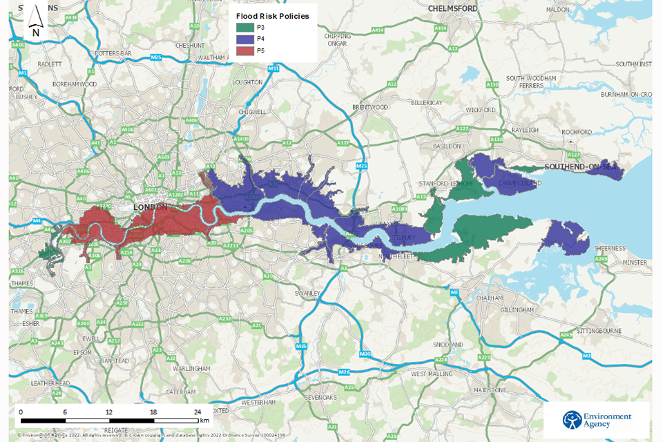
Map showing the 80km Thames Estuary area from Twickenham in the west to Southend-on-Sea and Sheerness in the east. It shows where the flood risk policies P3, P4 and P5 apply. P3 applies to Twickenham, Richmond and the outer estuary. P4 applies from Thamesmead to Tilbury, Canvey Island, Southend-on-Sea and the Isle of Grain. P5 applies to central London from Hammersmith to Greenwich.
Thames Estuary 2100 sets flood risk management policies for each area of the estuary. The policies outline how we should manage that area’s tidal defences as sea levels rise.
They range from policy 3 (P3) to policy 5 (P5), and are based on social, economic and environmental factors.
Policies help target Thames Estuary 2100 investment to the areas that need it the most.
Some landowners may wish to give their property a higher level of flood risk protection than the policy we have set. They have the right to invest and manage their flood risk in consultation with the Environment Agency and other risk management authorities.
The policies are:
- Policy 5 (P5) – take further action to reduce the risk of flooding
- Policy 4 (P4) – take further action to keep up with climate and land use change so that flood risk does not increase
- Policy 3 (P3) – take action to maintain flood defences at their current level, accepting that the flood risk will increase
Where the policies apply
We have divided the estuary into 23 areas called policy units and given each unit a flood risk management policy based on local factors.
P5 and P4 areas
The majority of areas upstream (west) of the Thames Barrier, on both banks of the river, have P5 policies.
The majority of areas downstream (east) of the Thames Barrier, on both banks of the river, have P4 policies.
The Environment Agency, councils and landowners are working to identify defence upgrades required in P5 and P4 areas, to prepare for sea level rise.
P3 areas
The P3 areas in the outer estuary are mostly made up of marshes. Here, major investment in upgrading flood defences would not represent good value for public money because it would benefit very few properties as there is little property affected. As storm events become more frequent and sea level continues to rise over the course of the century, flooding will occur more often in these areas.
There are exceptions where some flood defences within these areas will be upgraded, because they protect major infrastructure like roads or railways.
There are also P3 areas in west London. Flood risk will increase in these areas when the Environment Agency stops using the Thames Barrier to manage smaller river (fluvial) floods. However, in these areas we will work with communities to put alternative measures in place to manage flood risk. Read outcome 4: maintaining the Thames Barrier until 2070 for more information.
In P3 areas, risk management authorities and communities must work together to increase local resilience. This could include creating emergency flood plans, raising awareness of what to do in a flood, and making properties more resilient.
Updates to this page
-
Page updated to include information on where the Thames Barrier could be located, including maps.
-
First published.