United Kingdom Non-quota landings from EU waters 2021 & 2022
Updated 8 November 2022

© Crown copyright 2022
This publication is licensed under the terms of the Open Government Licence v3.0 except where otherwise stated. To view this licence, visit nationalarchives.gov.uk/doc/open-government-licence/version/3 or write to the Information Policy Team, The National Archives, Kew, London TW9 4DU, or email: psi@nationalarchives.gov.uk.
Where we have identified any third party copyright information you will need to obtain permission from the copyright holders concerned.
This publication is available at https://www.gov.uk/government/statistics/united-kingdom-non-quota-landings-from-eu-waters-2021-2022/united-kingdom-non-quota-landings-from-eu-waters-2021-2022
1. Key Statistics
- In 2021 UK vessels landed 11,900 tonnes of Non-quota species from EU waters.
- In January to June 2022 UK vessels landed 4,300 tonnes of Non-quota species from EU waters, which was an 8 per cent increase on the same period in 2021.
- The key species landed include: Edible crab; Great Atlantic scallop; Whelk; European lobster; and Pilchard.
- The majority of activity in EU waters was by the over 24m UK fleet, accounting for 56 per cent of the landings, mainly targeting Greater Atlantic scallop.
- In 2021 and the first half of 2022, the majority of landings in EU waters for Non-quota species were by Scottish administered vessels (50 per cent and 57 per cent respectively), predominantly targeting Greater Atlantic scallop and Edible crab.
- In 2021 English vessels landed 46 per cent of the total UK catch in EU waters, targeting Edible crab, Greater Atlantic scallop and Whelk.
- The landings by UK vessels of Queen Scallops in EU waters in 2021 reduced from 17 to zero tonnes when using the reported compared to the apportioned EEZ method.
- When comparing 2021 landings with the average annual landings in the period 2017-191, total landings reduced by 18 per cent.
1.1 About this statistical release
The reports published here include UK activity calculated using data collected and processed by officials of the various Fisheries Administrations in the UK, namely the MMO, Marine Scotland, DAERA, and WAG; as well as the Crown Dependencies of Jersey, Guernsey and the Isle of Man.
The data helps understanding of UK vessel landings in the EU Economic Exclusive Zone (EEZ) of capture. From 2021 this is based on the reported zone, however comparisons with previous years are based on estimates to determine the EU EEZ of capture (further information on the methodology to determine EEZ below).
This is a new dataset and remains provisional as we continue to improve the quality of this data, in particular with the EEZ area of activity. Final data for 2021 will be published with our annual national statistics publication in September.
This series will be updated monthly to allow comparisons of uptake in the current year with the previous year based on the reported area of activity. Data prior to 2021 is based on the estimated EEZ by spatial apportioning, therefore caution is advised when assessing differences with years before this date due to the alternative methodology used. This is however the most reliable data available to the MMO to determine UK fishing vessel activity in EU waters prior to 2021.
This series is being released as ‘Experimental’ statistics as it does not fully meet the requirements for a national statistics release. We are currently assessing and improving the data quality with the intention of badging this release as ‘national statistics’, in line with the UK Statistics Authority’s Code of Practice for Statistics.
1.2 Landings by UK vessels in EU waters
In 2021 landings of the main Non-quota species (Edible crab, Greater Atlantic Scallop, Whelk, European lobster, Pilchard) accounted for 89 per cent of the total UK vessel landings in EU waters. The majority of this activity was in the Central North Sea (34 per cent) and the Western English Channel (29 per cent). In 2021 the ‘over 15m’ UK fleet accounted for 91 per cent of the total Non-quota activity in EU waters.
The majority of landings by species group for Non-quota uptake by UK vessels in EU waters in 2021 are for Molluscs (6 thousand tonnes) and represent 51 per cent of the total.
1.3 Table 1 Non-quota species landings by UK vessels in EU waters in 2021 by sea area (Data represents landings by 6 main species).
| Sea Area | Live weight (tonnes) |
|---|---|
| Bay of Biscay - Central | 2 |
| Bristol Channel | 3 |
| Celtic Sea North | 1 |
| Celtic Sea South | 54 |
| Central North Sea | 4,087 |
| Eastern English Channel | 2,501 |
| Irish Sea | 256 |
| Southern North Sea | 41 |
| Southwest of Ireland - East | 2,501 |
| West of Scotland | 147 |
| Western English Channel | 3,436 |
| Total | 10,526 |
1.4 Chart 1: Non-quota species landings by UK vessels in EU waters: 2021
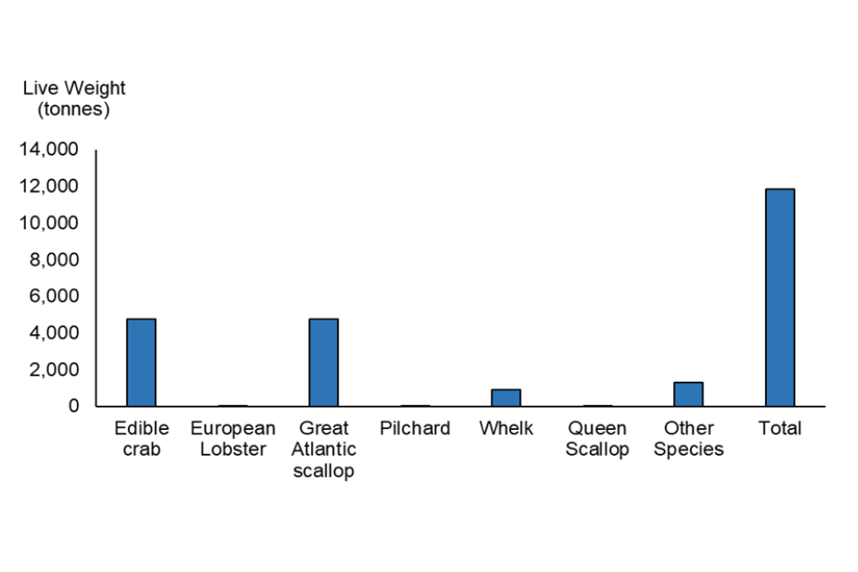
Edible crab and Scallops contributed the majority of the live weight in metric tonnes caught, accounting for 80 per cent (40 per cent each) of the total non-quota species landed.
Comparing the first six months of 2022 with the equivalent period in 2021, total Non-quota species by UK vessels in EU waters increased by 8 per cent, with Greater Atlantic scallop alone increasing activity by 34 per cent when compared to 2021. Significant reductions were observed for Whelk (down 84 per cent) and Pilchard, (down 75 per cent).
1.5 Table 2. Non-quota species landings by UK vessels in EU waters in January - June: 2022 vs 2021
| Species | 2021 | 2022 | 2022 v 2021 |
|---|---|---|---|
| Edible crab | 841 | 944 | 12% |
| European lobster | 24 | 25 | 5% |
| Great Atlantic scallop | 1,876 | 2,517 | 34% |
| Pilchards | 21 | 5 | -75% |
| Whelk | 553 | 91 | -84% |
| Other Species | 676 | 716 | 6% |
| UK total | 3,992 | 4,298 | 8% |
The Trade and Cooperation Agreement (TCA) between the United Kingdom and European Union includes the objective of ensuring the fishing activities for shared stocks are environmentally sustainable. Although the management of Quota-species stocks within UK/EU waters have been established, currently an effective strategy for the management of Non-quota species uptake has yet to be finalised. Discussions between the UK and EU are currently progressing to ensure such a management plan, with the aim of implementing from January 2023.
To inform and agree a strategy reliable data is essential to assess Non-quota fish uptake by UK vessels in EU waters, and corresponding uptake by EU vessels in UK waters. The data in this report represents the UK’s best estimate of our activity in EU waters and are exchanged with the EU monthly. The UK also receive corresponding data for EU vessel activity in UK waters, however this data is not currently published.
The MMO published an earlier report to include activity for UK activity in EU waters the first six months of 2021, however this was based on estimated statistical sea rectangle methodology. Although at the time of publishing this was the best estimate of the EEZ of capture, significant differences were observed when later comparing with the reported area of capture. The estimated approach relied on dividing the statistical sea rectangles, where they spanned across UK/EU waters, to estimate activity by EEZ. For details of this methodology please refer to ANNEX 2 of UK Sea Fisheries Statistics 2020. An example to illustrate follows:
If an ICES rectangle is fully in UK waters, we can assume 100% of the catch assigned to that rectangle is from UK waters. However, EEZ lines intersect and cut across ICES rectangles so this assumption cannot be applied in all instances. For example, in the English Channel, the ICES rectangles span both UK and French waters. Imagine the sea surface of an ICES rectangle falls in a way so that exactly 50 per cent of the ICES rectangle is in UK waters and 50 per cent is in French waters. Based on the per cent of the sea surface that falls in each nation’s EEZ we make an assumption that 50 per cent of the catch reported against that ICES rectangle was from French waters and 50 per cent was from UK waters. This same calculation can be done for all ICES rectangles and aggregated up to various groupings to estimate e.g., the percentage of landings by the UK fleet from UK waters compared to the percentage of landings from EU waters. In reality, the example of the English Channel described above, a vessel may have actually landed 100% of their catch on the UK side of the EEZ.
From 2021 vessels were required to report fishing activity by EEZ, differentiating between UK and EU waters. From this date the EEZ of capture will be determined by using the landings data as reported in vessel logbooks. For certain activity, such as Whelk and Queen Scallop, a significant proportion were originally assessed as being caught in EU waters in 2021 based on the estimated EEZ, however based on the actual reported EEZ landings were significantly greater in UK waters.
2. Glossary of terms used in this report
Economic Zone
The term Exclusive Economic Zone (EEZ), is taken to mean the entire zone under the exclusive jurisdiction of a coastal state or international organisation. This will include the territorial seas which span 0 to 12 nautical miles from the coast as well as the UNCLOS Exclusive Economic Zone from 12 to 200 nautical miles (or 22 to 370 kilometres) from the coast. Where EEZs would overlap, a median line is used to delineate the sovereignty of waters.
ICES Statistical Rectangles
The International Council for the Exploration of the Sea (ICES) has implemented spatial divisions of the sea for statistical analysis in major fishing area 27. ICES rectangles are the lowest broadly available unit of spatial reporting for this area. Each rectangle is 0.5 degrees latitude by 1 degree longitude.
3. Feedback
This is a new statistical release and as such in development to improve both the content and the quality of the data. If you have any recommendations or observations that would help to improve this release please send them to the MMO Statistics and Analysis Team (SAT) - statistics@marinemanagement.org.uk
4. Contact details
4.1 Callum Etridge
Marine Management Organisation Statistics and Analysis Team 1st Floor, Seacole Block 2 Marsham Street London SW1 4DF
Telephone: 0300 123 1032 Website: MMO website Email: info@marinemanagement.org.uk