Till and Tweed abstraction licensing strategy
Published 24 June 2022
Applies to England

© Crown copyright 2022
This publication is licensed under the terms of the Open Government Licence v3.0 except where otherwise stated. To view this licence, visit nationalarchives.gov.uk/doc/open-government-licence/version/3 or write to the Information Policy Team, The National Archives, Kew, London TW9 4DU, or email: psi@nationalarchives.gov.uk.
Where we have identified any third party copyright information you will need to obtain permission from the copyright holders concerned.
This publication is available at https://www.gov.uk/government/publications/till-and-tweed-abstraction-licensing-strategy/till-and-tweed-abstraction-licensing-strategy
1. About the licensing strategy
1.1 Overview
This strategy sets out how we manage new and existing abstraction and impoundment within the Till and Tweed catchment in the Solway Tweed river basin district.
It ensures that we:
- meet River Basin Management Plan (RBMP) objectives for water resources activities
- avoid deterioration within this catchment
We apply this approach to the water body in which the abstraction is located.
It also applies to:
- all downstream surface water bodies that may be affected by any reduction in abstraction related flow
- adjacent groundwater bodies affected by any reduction in groundwater level
The strategy also sets out local approaches to the sustainable management of water resources in collaboration with partners.
Managing water abstraction describes the technical explanation, legal and policy requirements behind the abstraction licensing strategies (ALS).
The abstraction pages advise on:
- who needs an abstraction or impoundment licence
- how to apply for a licence
1.2 How is the licensing strategy set out?
This ALS provides an overview of how water is sustainably managed in the Till and Tweed catchment to:
- provide water for abstraction
- protect the environment
The following is a summary of what each section covers:
Catchment overview - sets out additional information about the catchment and the influences and pressures on water availability.
Water resource availability - explains how much water is available for abstraction in the catchment.
How we manage water resource availability - explains the local licensing approach for the catchment which is summarised in table 2. This includes the potential water available for licensing and the restrictions that would be required.
Managing the catchment together - details the actions we are taking where abstraction is currently unsustainable in the catchment. Approaches to ensure sustainable water management in the future are outlined, including information on licence trading.
Related links - are listed for further information on water resource management.
Glossary - explains technical terms included throughout this document.
Contact details - on how to get in touch.
Note: whilst our assessment tools are continuously updated, we aim to update this document on a 3 year basis. Therefore some details within this document, for example hands off flow (HoF) values may be outdated. Use this document as a guide to water availability. For up to date advice see the contact details section.
1.3 Collaborative and sustainable water management
Our long term goal is to manage catchments so that there is sufficient water for people and the environment in the face of climate change. To help address this we need a stronger collaborative focus for water resources. We are working with abstractors and catchment groups to:
- develop local solutions to existing pressures
- prepare for the future
Catchment groups may include a variety of different partnership groups such as:
- abstractor groups
- local catchment partnerships
- environmental groups
In several priority catchments across England we have explored:
- modern and innovative ways of improving access to water
- alternative ways to achieving sustainable abstraction
The Till and Tweed catchment was selected as a priority catchment in the Defra water abstraction plan. This plan sets out how the government will reform the way we manage water abstraction, to protect the environment and improve access to water.
We assessed water resource availability using our standard approach. We have worked with partners to identify and trial local opportunities to modernise abstraction management.
Background information on the priority catchment project is available in section 2, catchment overview. Further details and links on approaches trialled in this catchment are provided in section 5, managing the catchment together.
This strategy is a tool to make informed decisions on the choices abstractors make about their use of water. We want this strategy to help abstractors to better understand the local water resource situation. This will help them to plan their water use and become more resilient in the face of climate change.
As water availability changes over time, we will need to evolve our strategy. The strategy reflects how we currently manage water resources alongside more forward looking regional plans and the Water Resources National Framework.
We will adapt our approach to reflect changing water availability by:
- updating the natural flow data used in assessing water availability to reflect a shifting baseline - we are currently extending the period of record from 1990 to 2007 to 1990 to 2020 and plan to continue to update this 30 year period going forwards
- continuing to use our existing and future regulatory powers to ensure sustainability - as we move into the Environmental Permitting Regime, the permit review process will regularly evaluate the sustainability of abstraction permits at a catchment level
2. Catchment overview
2.1 Catchment extent
The River Tweed catchment is extensive, with the majority falling to the north of the border within Scotland. Almost all of the River Till catchment falls within England. The Till and Tweed catchments are located within the Solway Tweed River Basin District.
For the purpose of this strategy we have only calculated water availability for the areas of the Tweed catchment which are located within England. These parts of the catchment are regulated by the Environment Agency. Abstraction licensing within the Scottish areas of the Tweed catchment are regulated by the Scottish Environment Protection Agency (SEPA) and fall outside of this strategy.
To complete this strategy we have obtained some environmental and abstraction data for the Upper Tweed catchment from SEPA. This data may impact on downstream river flows and water availability within England.
Map 1: extent of the wider Till and Tweed fluvial catchment (to the Tweed estuary)
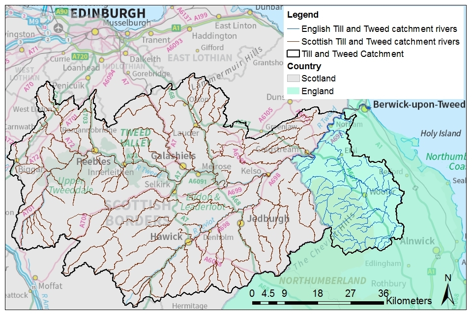
© Environment Agency and Scottish Environment Protection Agency copyright
Map 1 highlights the large area of the upper catchment which is located outside of this strategy, in Scotland. For clarity, this document and the information it presents relates to the part of the catchment which lies within England, shaded green.
2.2 Landscape and land use
The catchment extends across the most northerly areas of Northumberland up to the border with Scotland. The catchment covers an area of approximately 690 km2.
There is a strong rural feel to much of the area. The largest towns are Berwick-upon-Tweed and Wooler, with small villages scattered throughout the rest of the catchment. The local economy is dominated by tourism and agriculture with the landscape reflecting this. Upland hill farming dominates the western extent of the catchment along the Cheviots. Productive arable farming dominates central and eastern areas, especially in the lower valley bottoms.
- population: 20,500 to 21,000 (local authority modelled census data)
- 217 farms covering 76,513 hectares of farm land (Defra farm statistics)
Land use statistics based upon LCM2019 © NERC (UKCEH) 2020:
| Land Use Type | Proportion of catchment (%) |
|---|---|
| Permanent grassland and heather moorland | 44.9% |
| Arable | 34.4% |
| Urban | 2% |
| Forested | 12.7% |
| Other | 6% |
The photograph shows the River Till at Heaton Mill gauging station looking downstream. Heaton Mill is a short distance upstream of assessment point 4 and the confluence of the Till with the River Tweed. The setting is typical of the lowland valleys of the rural catchment.

The photograph shows the River Tweed within Berwick-upon-Tweed near to the Scottish border. This is the most urban location within the Till and Tweed catchment.

2.3 Water resources
The catchment incorporates the following rivers and their tributaries:
- River Till and its tributaries: Wooler Water, River Breamish and River Glen
- the section of the River Tweed which flows within the English boundary to the coast
The Till drains into the Tweed which discharges to the North Sea and acts as the northern boundary between England and Scotland.
The majority of abstractions from surface waters within the Till catchment are for crop irrigation, with many farmers growing potatoes commercially.
The Fell Sandstone is the only principal aquifer located within the catchment. It is mainly utilised for public water supply in Berwick and Wooler by Northumbrian Water Limited (NWL). It is utilised for private water supply across the majority of the catchment.
Scottish Water operate several reservoirs in the upper Tweed, within Scotland, for public water supply. This includes Talla Reservoir (National grid reference: NT 107 228) from which they make freshet releases.
There are 38 abstraction licences within the English Till and Tweed catchment, all are full licences. NWL is the only water company within the Till catchment, accounting for 5 abstraction licences.
8.7 million m3 per year of water is licensed for abstraction (total licensed quantity)
- 38 licensed abstractions
- 26 licences with hands off flow (HoF) restrictions at 4 gauging stations
- 95.2% of licensed volume within catchment from a groundwater source
- 28% of the catchment underlain by principal aquifer
Proportion of different sectors’ abstraction based on licensed abstraction quantity:
| Abstraction licence sector | Proportion of total licensed quantity (%) surface and groundwater combined | Proportion of total licensed quantity (%), groundwater only |
|---|---|---|
| Public water supply and other potable uses | 85.1% (7,431,646 m³/y) | 89.4% (7,431,646 m³/y) |
| Agriculture | 5.6% (489,146 m³/y) | 0.8% (66,511 m³/y) |
| Industry | 9.3% (815,000 m³/y) | 9.8% (815,000 m³/y) |
| Amenity/environmental | 0% | 0% |
| Power generation | 0% | 0% |
2.4 Climate change
Climate change will likely impact on the quantity and seasonal availability of water resources within the catchment.
The projected climate change impacts on rainfall and river flow for the North East of England by the 2050s are for:
- rainfall to decrease by 31% in the summer but increase by 25% in the winter
- low flows to be 65% lower but peak river flows to be 30% higher
Climate change projections are estimated using medium emissions data and 50% probability from UKCP09, consistent with a 4ºC rise by 2100. Further details on the assumptions used can be found in the Environment Agency Climate impacts tool.
2.5 Environment and sustainability
48 designated protected areas (SACs, SPAs, SSSIs, LNRs and LWS)
Licence reductions:
A number of existing groundwater abstractions from the Fell Sandstone are currently capped at volumes below their licence limit. These caps are likely to be in place until 2025 when alternative abstractions are expected to be installed and licence changes are completed.
Water Framework Directive:
- 21 surface water bodies
- 0% surface water bodies at good status or higher (100% classified as moderate)
- 9% water bodies where flow pressure does not support good status
- 2 transitional and coastal (TraC) water bodies
- 0% TraC water bodies at good status or higher
- 2 groundwater bodies
- 0% of groundwater bodies at good status, 50% poor status due to abstraction impacts
2.6 Partnership working
The Till and Tweed catchment was selected as a priority catchment in the Defra water abstraction plan. Since 2019, we have been working with water users and other partners exploring modern ways of managing water.
We are working together across sectors including:
- agriculture
- public water supply
- private water supply
- environment and recreation (including fisheries)
- natural flood risk management
This will deliver multi-functional outcomes which are good for:
- the environment
- people and business
This catchment was selected as a priority catchment for a number of reasons including:
- surface waters within the Till and Tweed catchment were exempt from abstraction licensing prior to 2018 (Border Rivers exemption)
- small scale abstractions from groundwater were exempt across the whole of North East Area prior to 2018 (Northumbrian Water Act exemption) - this included within the Till and Tweed catchment
- fisheries regulation within the catchment remains under the remit of the River Tweed Commission (RTC)
- there is high demand for water due to low rainfall and a large agriculture sector during summer whilst river flows are low
- there is the potential to share water between abstractors
- abstractors are keen to trial innovative approaches to regain some of the flexibility they had in abstracting whilst they were historically exempt from regulation
The Till and Tweed Catchment Partnership, hosted by the Tweed Forum, is active in this catchment. They bring together stakeholders from a range of backgrounds to address issues in the catchment. In addition there are also several water resources and water quality themed groups which feed into the Catchment Based Approach (CaBA) partnership. Information on current partnership projects led by Tweed Forum can be found on the Tweed Forum website.
3. Water resource availability in the Till and Tweed catchment
3.1 Surface water availability
The method for calculating the water resource availability is explained in Managing water abstraction. Water availability is calculated at selected assessment points (APs). The maps show the water availability calculated at the AP, local water availability may differ.
There are 7 APs in the Till and Tweed ALS:
- AP1 Lower English Tweed: covers the Tweed to the tidal limit at Union Bridge, downstream of Horncliffe
- AP2 Upper English Tweed: covers the Tweed to the confluence with the River Till
- AP3 Tweed Border: covers the Tweed to the English border, just below SEPA’s gauging station at Sprouston
- AP4 Till: covers entire Till catchment, including the River Glen, River Breamish and Wooler Water
- AP5 Glen: covers the River Glen and its tributaries, including the Bowmont Water and College Burn (mid-Till catchment)
- AP6 Upper Till: covers the upper reaches of the Till catchment including the River Breamish and Wooler Water to their confluence with the River Till
- AP7 Wooler Water: covers the Wooler Water and its tributaries (including the Harthope and Carey Burns) to the confluence with the Till
Water resource availability colours and implications for licensing
We use colours to represent different surface water availability at a range of flows:
Water available for licensing
Green
There is more water than required to meet the needs of the environment. New licences can be considered depending on local and downstream impacts.
Restricted water available for licensing
Yellow
Full licensed flows fall below the Environmental Flow Indicator (EFI).
If all licensed water is abstracted there will not be enough water left for the needs of the environment. No new consumptive licences would be granted. It is likely we’ll be taking action to reduce full licensed risks. Water may be available if you can ‘buy’ (known as licence trading) the entitlement to abstract water from an existing licence holder.
Water not available for licensing
Red
Recent actual flows are below the EFI.
This scenario highlights water bodies where flows are below the indicative flow requirement to help support a healthy ecology in our rivers. We call this ‘Good Ecological Status’ (GES) or ‘Good Ecological Potential’ (GEP) where a water body is heavily modified for reasons other than water resources.
Note: we are currently taking action in water bodies that are not supporting GES or GEP. We will not grant further licences. Water may be available if you can buy (known as licence trading) the amount equivalent to recently abstracted from an existing licence holder.
The water resource availability is calculated and the colour assigned at 4 different flows:
- Q30 – the flow of a river which is exceeded on average for 30% of the time, therefore you would expect the river flow to be lower than Q30 on 256 days in an average year, that is, a higher flow
- Q50 – the flow of a river which is exceeded on average 50% of the time, therefore you would expect the river flow to be lower than Q50 on 183 days in an average year
- Q70 – the flow of a river which is exceeded on average for 70% of the time, therefore you would expect the river flow to be lower than Q70 on 110 days in an average year
- Q95 – the flow of a river which is exceeded on average for 95% of the time, therefore you would expect the river flow to be lower than Q95 on 18 days in an average year, that is, a low flow
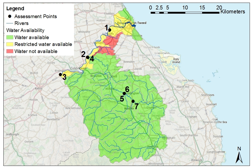
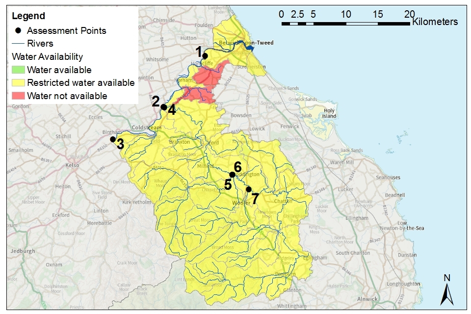
Water availability maps
The water availability colours for the Till and Tweed catchment are presented in maps 2 to 5.
Table 1: summary of maps 2 to 5 – water availability at each assessment point by flow category
| Assessment Point | Name | Q30 | Q50 | Q70 | Q95 |
|---|---|---|---|---|---|
| AP1 | Lower English Tweed | Available | Available | Restricted | Restricted |
| AP2 | Upper English Tweed | Available | Available | Restricted | Restricted |
| AP3 | Tweed Border | Available | Available | Restricted | Restricted |
| AP4 | Till | Available | Available | Available | Restricted |
| AP5 | Glen | Available | Available | Available | Restricted |
| AP6 | Upper Till | Available | Available | Available | Restricted |
| AP7 | Wooler Water | Available | Available | Available | Restricted |
Note: water availability status given in this table is at AP level, water availability may be different at a local level. For example, those water bodies in the lower catchment impacted by groundwater abstraction, further detail can be found in section 5.1.
Map 2: water resource availability colours at Q30 for Till and Tweed ALS
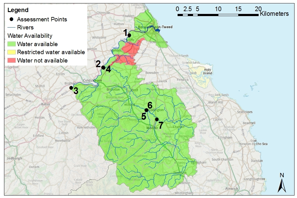
© Environment Agency copyright
Map 3: water resource availability colours at Q50 for Till and Tweed ALS

© Environment Agency copyright
Map 4: water resource availability colours at Q70 for Till and Tweed ALS
© Environment Agency copyright
Map 5: water resource availability colours at Q95 for Till and Tweed ALS
© Environment Agency copyright
3.2 Groundwater resource availability
Abstracting groundwater can impact on overlying surface water bodies. This impact is measured at the surface water AP. We cannot grant new groundwater licences where abstraction is reducing flows to below the indicative flow requirement to help support a healthy ecology. This is based on Q95 flows.
We must also account for:
- the available resource in the aquifer
- the impact of abstraction on protected sites
- the risk of saline intrusion
Groundwater resource availability colours and implications for licensing
We use colours to represent different groundwater availability:
Water available for licensing
Green
Groundwater unit balance shows groundwater available for licensing. New licences can be considered depending on impacts on other abstractors, designated ecological sites and on surface water.
Restricted water available for licensing
Yellow
Groundwater unit balance shows more water is licensed than the amount available.
But the actual situation is sustainable because either:
- recent actual abstractions are lower than the amount available
- management options are in place to deal with the known impacts
In restricted groundwater units no new consumptive licences will be granted. We may also investigate the possibilities for reducing fully licensed risks. Water may be available if you can ‘buy’ (known as licence trading) the entitlement to abstract water from an existing licence holder.
In other units there may be restrictions in some areas, for example in relation to saline intrusion.
Water not available for licensing
Red
Groundwater unit balance shows more water has been abstracted based on recent amounts than the amount available.
We will not grant further licences.
Groundwater availability maps
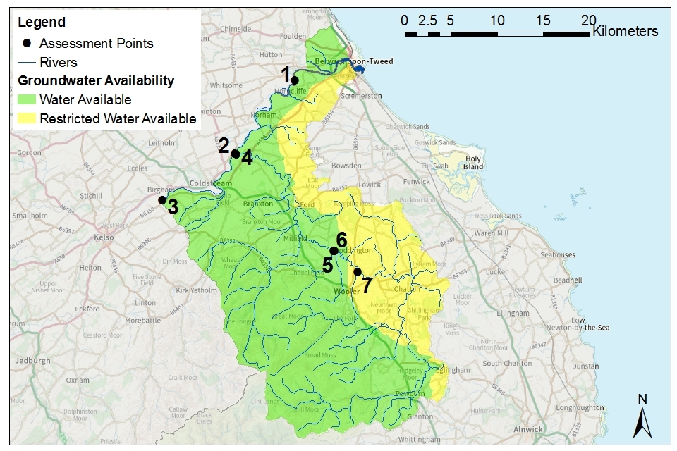
Map 6: groundwater availability in the Till and Tweed area
© Environment Agency copyright
3.3 Resource availability
If you want to apply for a licence, it’s worth considering the reliability of your abstraction.
By assessing the quantity of water available at different flows it’s possible to see:
- when there is a surplus or deficit of water
- the associated reliability of an abstraction
The reliability of an abstraction is the percentage of time water will be available throughout a year, during different flows.
At present we do not have sufficient flow and abstraction data to determine the reliability of new river abstractions at specific locations across the catchment. Actual reliability of a licence will be discussed when you apply.
3.4 Other considerations for resource availability and reliability
We will add constraints to licences such as hands off flow (HoF) conditions to protect:
- the environment
- the rights of other abstractors
As a result, when we grant a licence, it doesn’t mean that we guarantee a supply of water. These conditions specify that if the flow in the river drops below what’s needed to protect the environment, abstraction must reduce or stop. In dry years, restrictions are likely to apply more often. This will affect the reliability of supply.
There is no guarantee that we will grant licences even where water is available for abstraction. This is because we have to determine each application on its own merits. Local factors may mean we’re either unable to grant a licence as applied for, or even at all.
New licences within a catchment are usually given a common end date (CED), which allows them to be reviewed at the same time. The next CED for this ALS is 31 March 2027 and the subsequent one is 31 March 2039.
3.5 Impoundments
Applications for impoundments will be dealt with on a case-by-case basis. More information may be found on our water management web pages.
4. How we manage water availability in the Till and Tweed ALS
4.1 Surface water
We assess surface water flows at assessment points (APs). These are significant points on a river, often where 2 major rivers join or at a gauging station. APs cover multiple surface water bodies.
Where groundwater abstractions directly impact on surface water flows, the impact is measured at the surface water AP. The geology of the catchment is very variable and complex. There is expected to be connectivity between ground and surface waters in some areas of the catchment. Connectivity is likely where soils and superficial deposits (covering materials) are:
- thin or absent
- where groundwater levels are high
- where shallow abstractions are proposed
At present we do not have sufficient information to identify APs where connectivity may be relevant. Therefore site specific assessments are likely to be required.
Table 2 gives an indication of:
- how much water is available for further abstraction
- the associated restrictions we may have to apply to new and varied abstraction licences from the main river
Depending on the nature of the catchment, tributaries to the main river may be subject to different restrictions and quantities. This may be assessed locally on a case-by-case basis.
Each HoF is linked to an AP and is dependent on the resource availability at that AP. In some cases additional restrictions may apply to licences where there is a more critical AP resource availability downstream. This protects the ecological requirements of the river and other water users. This is detailed in the last column of table 2 if applicable.
All abstraction licence applications are subject to an assessment. This takes account of any local and downstream issues. It may be subject to further restrictions.
Reading from top to bottom in table 2 are the APs in the Till and Tweed ALS area.
Reading across the columns you can see:
- the potential HoF that may be applied to a licence
- the number of days water may be available under this restriction
- the approximate volume of water in megalitres per day (Ml/d) that may be available
In cases where there is water available at all flows we may apply a minimum residual flow (MRF) to protect very low flows. We’ll decide this on a case-by-case basis.
The Tweed SAC (Special Area of Conservation) and Till Rivers SSSI (Site of Special Scientific Interest) covers much of the catchment. Natural England and, if appropriate, NatureScot, will be consulted on all new applications or variations that fall within or could impact the designated site(s). No additional water will be licensed that could negatively impact any designated site.
The majority of the water bodies within the Tweed SAC and Till Rivers SSSI are also classified as having a high hydrological regime. This means that they are in near natural condition. To protect this status, there is expected to be limited new water available at lower flows (Q95 and potentially Q70) within these water bodies. Any new applications will be dealt with on a case-by-case basis.
Our preference is to encourage water trading with existing licensed abstractions before considering new licences in the Tweed SAC and Till Rivers SSSI. This would be the case where multiple applications are received at the same time, for water from the same river stretch(es). If water trading or sharing is not feasible applications will be considered on their individual merit.
Table 2: summary of licensing approach for the assessment points of the Till and Tweed ALS
| AP | Name | AP National Grid Reference | Water resource availability | HOF restriction (Ml/d) | Number of days per annum abstraction may be available | Approximate volume available at restriction (Ml/d) | Is there a gauging station at this AP? | Additional restrictions |
|---|---|---|---|---|---|---|---|---|
| AP1 | Lower English Tweed | NT 93407 51032 | Restricted water available for licensing at Q70 | 2,837 | 248 | 174 | Use SEPA gauge | |
| AP2 | Upper English Tweed | NT 86891 43016 | Restricted water available for licensing at Q70 | 2,573 | 248 | 124 | Use SEPA gauge | |
| AP3 | Tweed Border | NT 78997 37973 | Restricted water available for licensing at Q70 | 2,390 | 248 | 85 | Use SEPA gauge | |
| AP4 | Till | NT 87028 42980 | Restricted water available for licensing at Q95 | 348 | 248 | 69 | Yes | Restriction 1 - see below |
| AP5 | Glen | NT 97625 32515 | Restricted water available for licensing at Q95 | 132 | 248 | 37 | No (site closed) | Restriction 1 - see below |
| AP6 | Upper Till | NT 97688 32500 | Restricted water available for licensing at Q95 | 151 | 248 | 29 | No (but can use combined flows from 2 upstream) | Restriction 1 - see below |
| AP7 | Wooler Water | NU 00188 30200 | Restricted water available for licensing at Q95 | 45 | 248 | 15 | Yes | Restriction 1 – see below |
Restriction 1 – Common Standards Monitoring Guidance for Rivers (CSM) flow targets within the Tweed SAC and Till SSSI will be applied where required. These are <5% deviation at Qn95 and <10% at >Qn95 based on natural water flows.
Note: The water availability assessments for APs 1 to 3, located within the Tweed, are based on limited data and should represent a worse case scenario. This will impact the HoF restriction, including number of days water is available, at all upstream assessment points. We will update the water availability for the Tweed APs when additional information becomes available. A full review of the water availability across the whole catchment is expected in Spring 2023.
4.2 Groundwater
For major aquifers we may divide the area into groundwater management units (GWMU), which are sub-divisions of the groundwater bodies. In these cases we use the information and assessments on these units to determine water availability and licence restrictions.
Where groundwater abstractions directly impact on surface water flows the impact is measured at the surface water AP. This includes where the impact reduces baseflow. In these cases, restrictions may be applied to licences, such as hands off level (HoL) conditions. The HoL is a groundwater level below which an abstractor is required to reduce or stop abstraction.
Where the aquifer is deep in the ground, the impact of the abstraction is measured at the surface water AP where the rock outcrops (appears at surface). The interaction between the groundwater and the surface water occurs over a long timescale. This means the impact of groundwater abstraction does not occur at the time of abstraction. Therefore, there is only one groundwater status regardless of season or river flow. We take the water resource status at the low flows (Q95) as the groundwater status to ensure protection of the river environment. This is when the river environment is most vulnerable.
Other restrictions may apply where availability is limited or to protect the environment, for example to prevent saline intrusion.
Licence restrictions on groundwater abstraction in the Till and Tweed ALS area
GWMU 1 - Fell Sandstone
The Fell Sandstone comprises of a series of sandstone and mudstone units. In some areas, predominantly within and around Berwick, there may be insufficient water available in some of the sandstone bands to support additional abstractions. This restriction is to ensure recharge (rainfall) is not exceeded by abstraction and to prevent impact to existing abstractors or water dependent features. The GWMU is currently classed as restricted water available. All new consumptive abstraction applications, or increases to existing, will have to demonstrate that sufficient water is available from the targeted sandstone unit(s).
New abstractions near to the coast or tidal Tweed estuary may pose a saline intrusion risk. In these areas applicants will be asked to undertake an assessment of the saline intrusion risks during pre-application testing. Subsequent monitoring conditions and/or abstraction restrictions may be imposed on new abstraction licences where required.
4.3 Coasts and estuaries
The River Tweed estuary is located within the catchment. At present there are no known impacts to the estuary from abstraction or impoundments. The estuary is currently impacted by poor water quality resulting in opportunistic macroalgae and nutrient issues. Any new upstream abstractions or impoundments will need to ensure that they do not result in further deterioration of the water quality by reducing dilution.
The estuary has a number of national and European conservation designations. Some of the designations extend out of the estuary and along both the English (to the south) and Scottish (to the north) coastline. Natural England and NatureScot will be consulted on any new abstraction or impoundment that could reduce flows and impact the designated sites. This would mainly be for new abstractions which plan to abstract directly from the River Tweed, between AP3 (Tweed Border) and AP1 (Lower English Tweed).
4.4 High ecological status water bodies
High ecological status water bodies are those that are close to a natural condition. We restrict abstraction in these water bodies to maintain this condition.
The Till from source to Linhope Burn (GB102021072830) is the only high ecological status water body within the Till and Tweed catchment. Since 2013 the overall status of the water body has deteriorated due to poor water quality. There are no known abstraction concerns in this water body. There are no specific restrictions on new abstractions within the water body. Applicants will however need to demonstrate that additional abstraction would not impact ecology or lead to further deterioration in the status of the water body.
4.5 Protected sites
The Conservation of Habitats and Species Regulations 2017 (Habitats Regulations) provides a very high level of protection to 2 types of designated sites. This is due to their special environment. These are:
-
Special Areas of Conservation (SAC), which contribute to biodiversity by maintaining and restoring habitats and species
-
Special Protection Areas (SPA), which provide protection to birds and their nests, eggs and habitats
Government policy treats Ramsar sites (internationally important wetland sites) in the same way as SACs and SPAs. Ramsars, SACs and SPAs are referred to collectively as European sites. Sites of Special Scientific Interest (SSSI) also carry a high level of environmental importance.
Conservation objectives are the main objectives for European and SSSI protected sites to maintain at, or to reach, favourable condition. These are set by Natural England. The process for setting targets is described through the Joint nature conservation committee approved ‘Common Standards Monitoring Guidance’ (CSM). Natural England use these targets to assess the condition of European and SSSI protected sites. These quantitative targets are considered by Natural England as a pre-requisite for achieving the conservation objectives for European or SSSI designated sites.
We have a duty to have regard to Natural England’s advice when determining licence applications that may impact on a designated site. For any licence applications that may impact the River Tweed or estuary we have a duty to consult NatureScot as well as Natural England.
Across the catchment there are 4 SACs, 3 SPAs and 16 SSSIs of which 14 are water dependent. There are no Local Nature Reserves (LNRs) and 25 Local Wildlife Sites (LWSs).
The only 3 SPAs in the catchment are:
- Holburn Lake and Moss
- Northumberland Coast
- Northumberland Marine
The Tweed SAC and Till Rivers SSSIs are the most notable surface water dependent sites in the catchment. Ford Moss SAC and SSSI and Barelees Pond and Campfield Kettle Hole SSSIs all located on the Till Fell Sandstone groundwater body. None of the sites are currently impacted by abstraction but are known to be reliant on groundwater levels. Abstraction licences within or near to these areas may be subject to additional measures to protect the species and habitats of each protected area.
We may need more detailed supporting information when a licence application could impact on a designated conservation site. This will allow us to complete the required statutory assessment.
5. Managing the catchment together
5.1 Action on unsustainable abstraction
Managing water abstraction gives details on:
- what an unsustainable abstraction is
- the measures available to resolve environmental issues caused by abstraction
Till catchment (AP4 to AP7)
Prior to 2018 surface water abstractions within the Till and Tweed catchment did not require an abstraction licence. Abstraction licences were issued in March 2021 to abstractors who abstracted from surface water prior to 2018 (with evidence) and wanted to continue doing so. All of these licences have been given a short time limit and are issued until 2027. This short duration should enable additional catchment work to be completed; ensuring that none of the existing or any new surface water abstractions are unsustainable.
Till Fell Sandstone GWMU (GB40302G703700) and Newbiggin Dean and Horncliffe Mill Burn surface water bodies (GB102021073060 and GB102021073070)
The groundwater resource availability colour for the Till Fell Sandstone is yellow, restricted water available. The water resource availability in the Newbiggin Dean and Horncliffe Mill Burn is red, no water available. This means that flows do not currently support good ecology and the environment may be damaged as a result. Groundwater abstraction from the Fell Sandstone is understood to be the cause of the flow problem in the overlying Newbiggin Dean and Horncliffe Mill Burn. The objectives for this groundwater body in the Solway Tweed RBMP are to return the water body to good status by 2027.
Action that has been taken on unsustainable abstraction
Investigations have been completed to confirm whether groundwater is connected to and provides baseflow to either the Newbiggin Dean or Honcliffe Mill Burn. The investigations concluded that 3 water company abstractions abstract from the same sandstone unit (Peel Knowe Sandstone) of the Fell Sandstone as the watercourses. This confirmed connectivity between groundwater and surface water concludes that the groundwater abstractions may be unsustainable.
Two of the 3 groundwater abstraction boreholes are to be decommissioned and replaced with another from a different sandstone unit. The other borehole abstracts from multiple sandstone units within the Fell Sandstone and is to be re-engineered to disconnect it from the Peel Knowe Sandstone. If unsuccessful a second new abstraction borehole may be required. Work to replace and disconnect the existing abstractions is expected to be completed by the end of 2024. Whilst the work is being undertaken the abstractions will be capped at an agreed sustainable volume.
5.2 Approaches to sustainable water management
Prior to 2018 only groundwater abstraction within the Till and Tweed catchment were licensed, surface water abstractions were exempt from abstraction licensing. Surface water abstractions located within the designated stretches of the Till did however require a consent from Natural England. The consents were issued to ensure that the abstractions did not take too much water and cause deterioration of the SAC and SSSI.
Catchment based work to ensure sustainable abstraction commenced around 2003. It was at this time that it became clear that the abstractions within the catchment were going to require abstraction licences. Initially work focussed on making contact with existing abstractors and gaining an understanding of their water usage. Since 2018, the amount of catchment based work has increased and become focussed on identifying sustainable water management options.
We have focused on 3 main areas as part of the priority catchment work:
- determining future water needs and opportunities
- improving our understanding of the water environment
- creating better links and identifying innovative approaches
Determining future water needs and opportunities
Engagement with farmers and large landowners is continuing across the catchment to determine their future water needs. This information is being collated to understand whether there is going to be sufficient water available in the future.
Many of the existing abstractions are seasonal for crop irrigation, with peak abstraction during the summer months. Most abstraction occurs during months when river flows are at their lowest. This poses a greater risk to ecology and designated sites.
We are currently working with existing abstractors to identify opportunities to take more water during higher river flows when there is less risk. This would also give farmers a higher degree of certainty regarding water availability, especially during very dry periods. At present off-line, winter storage reservoirs seem to be a preferred option.
We will work with abstractors to:
- identify suitable locations and funding opportunities for reservoirs
- support them in obtaining the required permissions and approvals
Improving our understanding of the water environment
Prior to surface water abstraction becoming licensable in 2018, we had a limited understanding of the water environment in the catchment. In recent years we have vastly increased our hydrological (surface water) and hydrogeological (groundwater) understanding through various studies and by expanding our monitoring programme. This work is expected to continue for a number of years.
The catchment is known to be very variable. We will focus future hydrological work on understanding the tributaries of the Till and how each reacts differently during wet and dry periods. This knowledge will give a better understanding of how much water is available at a particular location.
The catchment is also known to be very dynamic. Historic maps show that the course of the River Tweed and its tributaries have moved on numerous occasions over time. Future work will focus on understanding the dynamics of the catchment. Gaining this understanding will help support abstractors on stretches that may be impacted in future and ensure the longevity of monitoring sites and assets. A review of existing monitoring sites and programmes will be undertaken, with additional monitoring requirements identified to reduce gaps in our knowledge.
We are continuing to work with the water company and the British Geological Survey (BGS) to improve our understanding of groundwater across the catchment. The geology of the Fell Sandstone to the west of Berwick has been mapped and modelled to show which rocks supply or could supply groundwater. The maps also identify areas of connectivity between groundwater and surface water. The maps and models are currently being extended to include the area around Berwick.
The work has:
- greatly improved our understanding of the groundwater supply
- helped determine whether existing groundwater abstractions are sustainable and where there is potential for additional abstractions in future
Creating better links and identifying innovative options
The priority catchment project helped improve our understanding of the catchment by engaging with the abstractor community. The project also sought opportunities for innovation for sustainable water management.
Hands off flows (HoF)
To date we have focussed much of our catchment work on understanding the current and future water needs of existing abstractors. This work aimed to ensure that there is enough water for all. We are now looking at options to make it easier for abstractors to comply with the conditions on their abstraction licences. Many abstractors have hands off flow (HoF) conditions meaning they need to stop abstracting during low flows. To inform them a HoF is in place abstractors are reliant on e-mail confirmations or looking at the real-time river levels on the internet. Work is on-going to ensure future HoF notifications are issued via automated text message which will be quicker and easier for abstractors to action.
Impact of woodland creation
A number of new woodlands and forests are planned across the catchment.
Tree planting can be beneficial for:
- reducing climate change
- natural flood management
- wildlife
Tree planting can greatly impact the water environment. An initial study was undertaken to identify where natural processes such as tree planting may be beneficial to the water environment. The study also identified where they may cause a negative impact such as reducing or redirecting recharge (input) into groundwater. Funding opportunities to continue with this work are currently being identified. Until further funding is obtained we continue to work with catchment partners and landowners to identify where land use changes could impact water resources.
Integrating water management
Water quality risks, particularly from nitrate, are a major concern in the catchment. There are a number of on-going and new catchment based projects. For example, the LIFE WADER project is focused on reducing water quality impacts. To be successful these projects will require a good understanding of how the catchment works, including rainfall patterns and river and groundwater flows. Future management of water resources in this catchment will focus on taking a more integrated approach. This type of approach should ensure that there is enough water for all and that the water is of good quality.
More information on work in other catchments can be found in the updated ALS for:
5.3 Water rights trading
A water rights trade is where a person sells all or part of their water right, as defined by their abstraction licence(s), to another person on a permanent or temporary basis. In the majority of cases a trade will involve a change in abstraction location and/or use. We will need to approve through the issue or variation of abstraction licences.
In licensing trades, as with new abstraction licences, we need to make sure that we don’t cause any deterioration in water body status.
This is both:
- within the water body / bodies where the trade will take place
- to downstream water bodies
This section provides a guide to the potential for trading in water bodies of a particular ALS water resource availability colour. Potential for water trading in the catchment is shown on maps 5 (all surface water and groundwater that impacts surface water flows) and 6 (groundwater).
Guide to potential trading based on water resource availability
Water available for licensing
Green
There may be opportunities to allow trades of recent actual abstraction and licensed abstraction. But little demand for trading expected within water body as water available for new abstractions.
Restricted water available for licensing
Yellow
There may be opportunities for licence holders to trade up to their full licensed quantities. But the quantities of water available to trade may be restricted once levels of actual abstraction reach sustainable limits. We will not permit licence trades in water bodies where we are taking action to prevent deterioration unless the trade is consistent with achieving water body objectives.
Water not available for licensing
Red
We will only trade recent actual abstraction but no increase in recent actual abstraction is permitted in water body. Licensed abstraction will be recovered for the environment.
To find out more about licence trading go to our water management pages.
We are in the process of developing new initiatives to support water trading in the Till and Tweed catchment. We will initially focus on surface water abstractors that abstract from the same or adjacent stretches. The majority of these abstractions are located in the upper and middle sections of the River Till. As the majority of abstraction is for irrigation a temporary seasonal trades trial may be the best option for this catchment. This type of trial is designed to help abstractors trade water over a single irrigation season. Abstractors would apply for these trades during a defined ‘trading window’ during the spring. All trading of water rights must go through a formal process, led by the Environment Agency. Less formal ‘water sharing’ may also be an option.
6. Related links
-
Agriculture and Horticulture Development Board (AHDB) website - provides information on effective use of water on livestock farms
-
Catchment Based Approach community website - provides further information on the catchment based approach
-
UK Centre for Ecology and Hydrology Drought Portal - is an interactive portal presenting information on the latest hydrological situation across the UK
-
Environment Agency, how to apply for a water abstraction or impoundment licence web pages - provide all the information needed to go through the application process to get a licence
-
Environment Agency manage your water abstraction or impoundment licence online web service - allows abstractors to view and share licence information and submit abstraction returns
-
Environment Agency priority catchments website - provides further information about the priority catchment work
-
Environment Agency National Framework for Water Resources - explores England’s long-term water needs and the importance of planning at the regional scale and link to the catchment scale
-
Linking Environment and Farming (LEAF) Simply Sustainable Water guide – explains 6 simple steps for managing water quality and industrial use
-
National Farmer’s Union web pages on Irrigation and water resources – provide useful information
-
Natural England’s website provides further information on protected sites and species
-
Environment Agency and Cranfield University’s guide to planning, designing, constructing and commissioning a water storage reservoir – if you are considering an irrigation reservoir
-
The UK Irrigation Association and Cranfield University - provide a range of irrigation booklets that tackle key issues
-
Waste and Resource Action Programme website has guidance on water efficiency in the food and drink industry
-
Waste and Resource Action Programme website has a guide to water saving devices and practices
7. Glossary
Abstraction - Removal of water from a source of supply (surface or groundwater).
Abstraction licence - The authorisation granted by the Environment Agency to allow the removal of water.
Assessment point - A significant point on a river, often where 2 major rivers join or at a gauging station.
Catchment - The area from which precipitation and groundwater will collect and contribute to the flow of a specific river.
Catchment based approach - Partnership working at the river catchment scale to deliver a range of environmental, social and economic benefits while protecting our precious water environments for the benefit of all.
Consumptive abstraction - Abstraction where a significant proportion of the water is not returned either directly or indirectly to the source of supply after use. For example for the use of spray irrigation.
Discharge - The release of substances (for example, water, treated sewage effluent) into surface waters.
Environmental Flow Indicator - Flow indicator to prevent environmental deterioration of rivers, set in line with new UK standards set by UKTAG.
Groundwater - Water that is contained in underground rocks.
Hands off flow - A condition attached to an abstraction licence which states that if flow (in the river) falls below the level specified on the licence, the abstractor will be required to reduce or stop the abstraction.
Impoundment - A structure that obstructs or impedes the flow of inland water, such as a dam, weir or other constructed works.
Surface water - This is a general term used to describe all water features such as rivers, streams, springs, ponds and lakes.
Water body - Units of either surface water or groundwater which we use to assess water availability.
8. Copyright - maps
© Environment Agency copyright and/or database right 2022. All rights reserved. This map includes data supplied under licence from: © Crown Copyright and database right 2022. All rights reserved. Ordnance Survey licence number 100024198.
9. Contact details for further information
You can call the Environment Agency on 03708 506 506 (calls cost no more than a national rate call to on 01 or 02 number) or email enquiries@environment-agency.gov.uk. For local water resources advice contact the North East Integrated Environmental Planning Team using the details above.