Thames Estuary 2100: 10-year monitoring review (2021)
Published 1 February 2021
Applies to England

© Crown copyright 2021
This publication is licensed under the terms of the Open Government Licence v3.0 except where otherwise stated. To view this licence, visit nationalarchives.gov.uk/doc/open-government-licence/version/3 or write to the Information Policy Team, The National Archives, Kew, London TW9 4DU, or email: psi@nationalarchives.gov.uk.
Where we have identified any third party copyright information you will need to obtain permission from the copyright holders concerned.
This publication is available at https://www.gov.uk/government/publications/thames-estuary-2100-te2100-monitoring-reviews/thames-estuary-2100-10-year-monitoring-review-2021
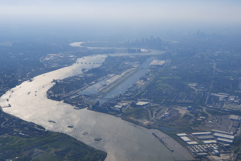
An aerial view of the River Thames and the Thames Barrier, looking west over Royal Docks
Foreword
Emma Howard Boyd, Chair, Environment Agency
Julia King, Baroness Brown of Cambridge, Chair of the Climate Change Committee’s Adaptation Committee
The Thames Estuary is an international hub of cultural, commercial and economic activity. Within its reaches are some of the country’s most valuable assets, critical infrastructure and transport networks, as well as internationally-protected habitats.
Over £321 billion worth of property and 1.42 million people are protected from flooding by a vast and complex network of tidal defences. At almost 40 years old and nearing its 200th closure, the Thames Barrier is the jewel in a 330 kilometre crown of flood walls, embankments, smaller barriers, pumping stations, and flood gates. These structures are all having to work harder as climate change accelerates.
We don’t yet know the full impact of the coronavirus and ongoing restrictions, but the recovery requires resilience in the Thames Estuary. Investing in our flood defences will help protect the Thames Estuary’s cultural, commercial and economic power in the decades to come.
Even if we reach the government’s required target of net zero by 2050, there is likely to be 59% more winter rainfall, and by the end of the 21st century, once-a-century sea level events are expected to become annual events. Alongside climate change, the population continues to grow. The outer estuary is recognised by government as a prime growth opportunity area, driven by the creation of the Thames Estuary Growth Board in 2019. This growth must be resilient to flooding.
The Thames Estuary 2100 Plan sets a long-term approach to managing this risk. It is internationally recognised as a leading example of a climate adaptation strategy, which enables practitioners and policy makers to plan, monitor and review how to adapt to flood risk over time.
Today, nearly 10 years on from the Plan’s original publication, we have new projections for sea level rise and river flows, population and property numbers. This monitoring report will help us understand what is changing in the estuary and will inform the 10-Year Review of the Thames Estuary 2100 Plan.
The 10-Year Review is an opportunity to reflect on our improved understanding of climate change impacts, introduce better ways of working, increase access to the river, create habitat, support sustainable and resilient development, and enhance the quality of life of people living here. We will publish an updated Thames Estuary 2100 Plan in 2022.
In addition to the 1.42 million people directly protected by flood defences, it is worth considering the impact of a major flood in the Thames Estuary. Millions more could be impacted by the closure of major transport hubs and critical infrastructure (such as hospitals and schools), businesses could suffer from lost time and customers, and the region’s reputation as a major business and tourist hub could be at risk.
Last year, the Environment Agency published a national Flood and Coastal Erosion Risk Management Strategy. This advocates an ‘adaptive pathways approach’ to planning for future risk. At the 26th United Nations Climate Change Conference (COP26) in Glasgow this year, the Thames Barrier and the Thames Estuary 2100 Plan can help demonstrate how ‘adaptive pathways’ work in practice.
No organisation is big enough to do this alone, which is why partnership working is essential. Individuals, businesses and government need to work together to create a resilient Thames Estuary. By making the right investment decisions at the right time, we can protect millions of people and support sustainable development that is more resilient to rising sea levels and other climate shocks.
Executive summary
Tidal flood risk in the Thames Estuary
Flooding can occur in the Thames Estuary when high tides coincide with low-pressure weather systems. This results in storm tides. Storm tides lead to additional water entering the estuary from the North Sea. Areas of low-lying land (floodplains) in the estuary would be at significant risk of flooding if flood defences did not protect them. As our population grows, more people could be at risk of tidal flooding as the number of people living and working on the floodplain increases. We must manage this risk carefully, as it is likely to continue to increase as our climate changes and sea levels continue to rise.
An adaptive strategy
In 2012, the Environment Agency and our partners published the first Thames Estuary 2100 Plan (referred to in this report as ‘the Plan’). This sets out a strategy for managing tidal flood risk in the Thames Estuary to the end of this century and beyond. The Plan is a frontrunner of the ‘adaptive pathways approach’ (also known as adaptation pathways). It sets out a series of possible ‘pathways’ for managing tidal flood risk in the Thames Estuary. This includes a decision-making framework for switching between pathways, using the latest climate projections as a basis for those decisions. It is the first strategy in the UK to set out recommendations for managing tidal flood risk for a range of possible climate futures.
We review and update the Plan as new data, scientific evidence and climate change projections become available. This ensures the Plan continues to set out the most effective way to manage tidal flood risk. The review process allows us to assess what has changed in the estuary. We can then either switch pathway, revise the recommendations for managing flood risk, or change the deadlines for delivering those recommendations. For example, if the projected rate of sea level rise increases, we can adapt the deadlines for raising defences to be earlier. However, if it decreases, we can make them later. If projections increase significantly, we can look at alternative options or pathways for managing the increasing risk of flooding. By following this approach, we can implement the most cost-effective solutions at the right time.
We published an updated National Flood and Costal Risk Management Strategy last year. This strategy recommends that risk management authorities should follow the adaptive pathways approach in developing flood risk management plans. Taking this adaptive approach enables policy makers and practitioners to plan for a wide range of resilience actions. This could include improving flood defences, but also nature based solutions, and sustainable land use management. Our learning from developing and implementing the Thames Estuary 2100 Plan will be invaluable for partners across the country in coming years.
The 10-Year review
Every 5 years, we assess whether the estuary has changed in line with the projected changes in the Thames Estuary 2100 Plan. As well as physical changes in the estuary, we also take the latest scientific guidance and policy changes into account. Every 10 years, we carry out a full review and update of the recommendations in the Plan. We expect the estuary to change and evolve between these reviews.
The 10-Year Review is the first full review and update of the Plan since its publication. There are 3 phases in the 10-Year Review:
- the monitoring review
- the economic review
- the update of the Thames Estuary 2100 Plan
The monitoring review looks at how the estuary has changed over the last 10 years. We use the data from the monitoring review as a baseline for measuring future change. We are also working with partners to identify the environmental, social, cultural and economic benefits the Plan could deliver.
The monitoring data and the benefits work will then be used to update the costs and benefits of the options in the Plan (the economic review). The economic review will inform our next programme of works for maintaining and upgrading flood defences in the estuary.
The economic review, alongside lessons learnt so far from delivering the Plan with our partners, feed into the review of the Plan’s recommendations for managing tidal flood risk and achieving the Plan’s wider aims (Figure 1).
Reviewing and updating the Plan’s recommendations includes 4 steps:
- draft recommendations - update the Plan’s recommendations based on economic review and lessons learnt
- partner review - review and agree draft updated recommendations with our partners
- public review - external consultation on draft recommendations
- finalise recommendations - agree final recommendations with partners
We will use the final recommendations in the development of the updated Thames Estuary 2100 Plan (and Implementation Plan). The updated Plan will be published in 2022.
We are now at the end of the monitoring review, and are working on the economic review with our team of consultants.

Figure 1: How the key findings of the monitoring review fit into the 10-Year Review programme.
Overview of the key findings report
This report is a summary of our key findings from the monitoring review. It suggests some early implications and next steps for this work within the 10-Year Review. This is an important initial stage that will eventually lead to the update of the Thames Estuary 2100 Plan.
We have set out our key findings as 10 high-level ‘indicators of change’. Each chapter includes our headline findings, why we monitor that indicator, and a more detailed explanation of the monitoring results.
The 10 indicators are:
- sea level rise
- extreme water levels
- river flows
- condition of flood defences
- Thames Barrier operations
- people, property, infrastructure and policy
- extent of erosion and deposition
- habitat
- social, cultural and commercial value
- public and institutional attitudes to flood risk
Each indicator contributes to the update of the Thames Estuary 2100 Plan in a different way:
- indicators 1, 2 and 3 will provide data for an update to our flood risk modelling and flood defence heights
- indicators 4 and 5 will help us assess progress made to deliver the Plan in the last 10 years
- indicator 6 will inform our review of flood risk management policies in areas of significant change
The above indicators, plus indicator 7, will contribute towards an updated programme for upgrading flood defences.
- indicator 8 will inform the update of our strategy for habitat compensation
- indicator 9 will support our assessment of wider benefits that the Plan will deliver
- indicator 10 will support a study of lessons learnt from the first 10 years of using the Plan with our partners
Each of the updated strategies, programmes and assessments will feed into the review of the Plan’s recommendations. We will then use this to update the Thames Estuary 2100 Plan and the Implementation Plan (the plan for how we will deliver these recommendations).
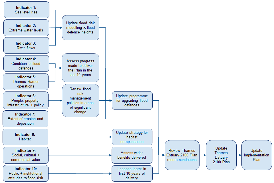
Figure 2: How we will use the key findings from each indicator to support updating the recommendations in the Thames Estuary 2100 Plan.
We have also produced a detailed technical report of our findings (available on request), in which we have divided the 10 indicators into 27 sub-indicators. The sub-indicators enable us to track physical and socio-economic changes that are important for reviewing the Plan. We are constantly improving our approach to monitoring change in the estuary over time. We will continue to address any gaps and refine which indicators we measure for managing tidal flood risk and achieving the Plan’s wider aims.
Headline findings
We have a number of headline findings from the monitoring review, which are covered in more detail in each chapter of this report. We will use these findings, with data from other studies, to update the recommendations for managing flood risk in the Thames Estuary 2100 Plan. For some indicators, further work is required to develop a better understanding of the impact of these findings. We have included the next steps below.
The headline findings are:
- sea level in the Thames Estuary has risen over the last century
- sea level rise has been accelerating over the last few decades
- new climate projections for the UK were published in 2018 (UK Climate Projections 2018)
- recent data shows that river flows are increasing, however, natural variability in data makes it difficult to assess whether these changes occur by chance or are persistent
- 97.5% of the tidal flood defences in the estuary are classified as meeting or exceeding their target condition
- we will prioritise the 2.5% of defences that are below their required condition for maintenance through our asset management programmes
- we expect we will need to close the Thames Barrier more frequently as sea level rise accelerates
- the number of people and properties in the Plan area has increased since 2009
In the plan area, there are now:
- 1.42 million people (14% increase)
- 586,000 residential properties (17% increase), worth £321 billion (61% increase)
- 55,640 commercial properties (39% increase – however this figure reflects improved datasets as well as real change)
Next steps
We will plan for a range of future climate change, including the highest scenario of sea level rise from the UKCP18 climate projections. This will inform our review of recommendations for managing tidal flood risk in the Thames Estuary 2100 Plan.
We will use outputs from other studies alongside these projections to update the deadlines for completing these recommendations.
The updated recommendations and deadlines will be published as part of the updated Thames Estuary 2100 Plan in 2022.
We will continue to collate data on river flows. This will make it easier to identify permanent changes in river flows and impacts on flood risk.
As part of our work to maintain and upgrade defences across the estuary, we will prioritise defences that are currently below their target condition.
We will assess any changes in numbers of Thames Barrier closures as sea level rise accelerates.
We will review the flood risk management policies set out in the Plan based on the changes in the number of people and property at risk. We will update the policies where appropriate.
We aspire to make the Thames Estuary an exemplar in zero carbon flood risk management. The Plan will contribute to the Environment Agency’s aim to become a carbon neutral organisation by 2030.
Wider findings
These findings do not have a direct impact on updating the recommendations in the Plan. However, they will affect how we manage our work, implement the Plan’s recommendations and achieve its aims.
The wider findings of the monitoring review are:
- erosion is occurring across the Thames Estuary, while deposition is occurring only in certain areas
- intertidal habitat in the estuary has naturally increased by 2.5% - the area of saltmarsh in the estuary has increased by 6%
- we have worked with the RSPB and DP World London Gateway to create new habitat at Wallasea (Essex) and Salt Fleet Flats Reserve (Kent) respectively - these new habitat schemes compensate for 58 hectares of habitat projected to be lost due to coastal squeeze by 2025
- managing tidal flood risk and the impacts of climate change is more important today than it was 10 years ago, according to organisations in the Thames Estuary (Environment Agency survey, 2020)
For the first time since the Plan was published, we have reviewed data on the number of social and cultural assets in the Plan’s area. There are approximately:
- 3000 ‘social assets’ such as theatres, and community/leisure centres
- 27 km² of open green space
- over 4000 listed buildings
- 4 World Heritage Sites
Next steps
We will monitor erosion more closely to detect and remedy the impacts as early as possible.
We will take changes to policy on biodiversity net gain and carbon neutral targets into account when we update the Plan. We will also capture data to support a future assessment of natural capital and biodiversity net gain. We will integrate this into the monitoring for the 15-Year Review in 2025.
We will continue to monitor changes in social, cultural and commercial value. A separate report (‘Assessment of delivery of wider benefits’) will use this data to determine whether the Plan’s aims are being met.
The Port of London Authority (PLA) is developing projections for river use until 2050, due to be published in summer 2021. We will incorporate the results into our update of the Plan’s recommendations for managing tidal flood risk.
We will reschedule a survey to measure public attitudes to flood risk when it is safe to do so. This survey was cancelled due to the Coronavirus pandemic.
We will work with partners and communities to improve awareness and understanding of the impacts of sea level rise. We will also identify how the Plan could help to manage these impacts.
We will continue to work with councils, the Greater London Authority, and developers to ensure that new development is flood resilient and safe. We will continue to recommend the ‘riverside strategy approach’, which integrates flood defence improvements into wider redevelopment. This supports the enhancement of the social, cultural and commercial value of the riverside. Newham and City of London councils are both developing riverside strategies, which will provide learning for others.
Acknowledgements
We would like to thank the following people and organisations for their support in the production of this report:
- Environment Agency colleagues who have provided input and expertise in the collation of data and reviewing the report
- the Met Office, who provided their expertise in peer reviewing indicators 1, 2 and 3
- University of Southampton, who produced Appendix B to support the analysis of changes to water levels
- members of the Thames Estuary 2100 10-Year Review Advisory Group, who provided advice and feedback on the draft report:
- Julia King, Baroness Brown of Cambridge, Chair of the Climate Change Committee’s Adaptation Committee
- Kathryn Brown, Head of Adaptation, Climate Change Committee
- Samantha Kennedy, Director of Environment and Climate Action Place and Public Health, Essex County Council
- Daniel Bicknell, Adaptation Manager, Greater London Authority (on behalf of Peter Daw, Head of Climate Change)
- Paul Illingworth, Project Director, Infrastructure and Projects Authority
- Caroline Bruce, Strategic Director of Environment and Leisure, London Borough of Southwark
- Robin Mortimer, Chief Executive, Port of London Authority
- Dr Martin Hurst, Chair, Southern Regional Flood and Coastal Committee
- Lawrence Gosden, Director of Strategy and Asset Management, Southern Water
- Julie Foley, Director of FCRM Strategy and National Adaptation, Environment Agency
- Jeanne Capey, London Area Director, Environment Agency
1. Sea level and 2. Extreme water levels
1.1. Key findings:
- sea level in the Thames Estuary has been rising over the last century - mean sea level at Southend-on-Sea has risen by approximately 15 cm between 1911 and 2018 (relative to land level)
- this is similar to the Intergovernmental Panel on Climate Change’s (IPCC) ‘likely’ range for global mean sea level rise
- sea level rise in the estuary has accelerated over the last few decades - sea level rose by about 1.4 mm per year (on average) between 1911 and 2018, relative to land level versus 3.6 mm per year between 1990 and 2018
- these rates of sea level rise are similar to the IPCC’s ‘very likely’ range of global mean sea level rise
- new UK climate projections (UKCP18) have been published since the Plan was developed - we are using the highest rate of sea level rise from these projections for the 10-Year Review
- we will use the latest sea level rise data and other information from the 10-Year Review to update the deadlines for upgrading tidal flood defences – the deadlines will be published in the updated Thames Estuary 2100 Plan in 2022
1.2. Why we monitor these indicators
The Thames Estuary 2100 Plan uses sea level rise projections to determine the most appropriate flood risk management options, and the deadlines for completing them. The original Plan set out 4 major deadlines for flood defence upgrades.
Table 1: Deadlines for flood defence upgrades in the original Plan.
| Deadline in the original Plan | |
|---|---|
| Defence raising downstream of the Thames Barrier | 2040 |
| Defence raising upstream of the Thames Barrier | 2065 |
| Thames Barrier upgrade/replacement and additional defence raising downstream of the Thames Barrier | 2070 |
| Additional defence raising upstream of the Thames Barrier | 2100 |
As the Plan is adaptive, we review and update these deadlines every 5 years. We do not propose to change the heights to which the defences need to be raised during each phase. We only change the dates those heights need to be achieved by.
Upstream of the Thames Barrier, there is a network of flood walls, embankments (shown in Figure 3 by the red lines) and high ground. These provide protection against high tides and and storm tides, until they reach a certain threshold. If they are predicted to cross this threshold, we will close the Thames Barrier to prevent water overtopping these defences. Downstream of the Barrier, a network of flood walls, embankments and smaller gates and barriers provide protection against storm tides. This is shown in Figure 3 by the blue lines. High ground also provides protection in certain areas.
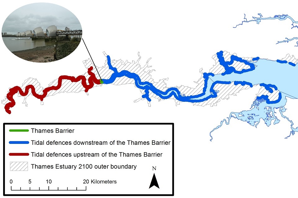
Figure 3: Location of tidal defences in the Thames Estuary - from Teddington to Shoeburyness and Sheerness.
The majority of the estuary has tidal flood defences. The Thames Barrier is located near Woolwich in East London. Areas that do not have tidal flood defences are mostly located to the east in the outer estuary where there is high ground.
The Thames Barrier and the network of defences work together to protect communities in the Thames Estuary from flooding from abnormally high tides (storm tides). A storm tide typically occurs when a storm surge (i.e. the abnormal rise of water caused by a storm) coincides with an astronomical high tide.
We use different water levels to assess when these defences need to be raised by. This is because of the different roles played by the defences upstream and downstream of the Thames Barrier.
There are 2 main factors that we measure related to water levels:
- changes in projections of water levels
- changes in the baseline we measure water levels from
Changes in projections of water levels
The defences downstream of the Thames Barrier (including the Barrier itself) need to be high enough to protect against different sizes of storm tides. The height of the Thames Barrier protects central London against a storm tide with a 1 in 1000 (0.1%) chance of occurring in any year. As sea level continues to rise, the height of storm tides will increase. The defences downstream of the Barrier will therefore need to be higher to prevent tidal flood risk increasing. We will also need to upgrade the Thames Barrier or replace it with a new, higher barrier further downstream. This will prevent tidal flood risk upstream of the Barrier increasing.
We rely on upstream flood defences to ensure we do not have to close the Thames Barrier on every high tide. The more frequently the Barrier closes, the more costly it is to maintain over the longer term to ensure its reliability. More frequent closures also means we have less time to complete essential maintenance on the Barrier and would impact navigation. By keeping the number of closures within a manageable limit (set at 50 per year on average), we can maintain the reliability of the Barrier.
To predict when we will reach the average closure limit, we use projected changes in a water level called ‘Mean High Water Springs’ (MHWS). This is the average height of the high tides experienced during the spring tides. At this time, we see the most extreme difference between the highest and lowest tides. In future, we will consider a new method for predicting future Thames Barrier closures. This method will take fluvial flow and other parameters (such as sea level) into account. This will improve our understanding of when to set our deadlines for raising defences upstream of the Thames Barrier.
Changes in the baseline we measure water levels from
In developing the Thames Estuary 2100 Plan, we used statistical analysis of historic sea level data to set a baseline for each water level. These baselines provide a starting point from which we can monitor change in the estuary. We have 2 baselines. One baseline is for a storm tide with a 1 in 1000 (0.1%) chance of occurring in any year. The other baseline is for the Mean High Water Springs tide. As we get a better understanding of how the estuary is changing, we expect to be able to calculate these baselines more accurately. Updating these baselines could also affect the deadlines for completing flood risk management actions. This can happen even if the projected rate of sea level rise does not change. If using higher baselines for these water levels, deadlines would be earlier than in the current Plan. If using lower baselines, they would be later.
1.3. Observed changes in water levels
We use tide gauges to monitor and record sea level in the estuary relative to the land level. These allow us to monitor:
- long-term changes in sea level caused by climate change
- short-term changes in sea level caused by meteorological conditions
- natural long-term cycles in mean sea level caused by astronomical effects
We worked with experts at Southampton University to extract the rates of long-term, climate change related sea level rise from the tide gauge records (relative to land level). We found that:
- mean sea level has risen by approximately 15 centimetres between 1911 and 2018, relative to land level at Southend-on-Sea - this is similar to the Intergovernmental Panel on Climate Change’s (IPCC) ‘likely’ range for global mean sea level rise of 12-21 centimetres between 1902 and 2015
- sea level rise in the Thames Estuary is accelerating - between 1911 and 2018, sea level rose by about 1.4 millimetres per year on average, relative to land level at Southend-on-Sea - between 1990 and 2018 it rose by about 3.6 millimetres per year on average
- this is similar to the IPCC’s ‘very likely’ range of global mean sea level rise of 0.8 - 2.0 millimetres per year between 1901 and 1990, and of 3.1 - 4.1 millimetres per year between 2006 and 2015
These findings suggest that the rate of mean sea level rise in the estuary is currently similar to the Defra06 projections in the original Plan. It is also comparable to the highest scenario in the 2018 UK Climate Projections (UKCP18). However, we can’t assume that sea level rise will continue to be similar to these projections in the future. Changes in global emissions or Antarctic ice sheet processes could significantly affect future changes in sea level. For this reason, it is important that we continue to monitor sea level in future reviews of the Thames Estuary 2100 Plan.
1.4. New projections of future sea level rise
Since the 5-Year Review (2015), the Met Office has published new climate change projections, known as UKCP18 (UK Climate Change Projections 2018). The Environment Agency has released new national guidance on how these projections should be used when developing a flood risk management strategy.
The Environment Agency’s guidance recommends assessing a range of future climate change scenarios, with a focus on the highest climate scenario from UKCP18. Where the scale of flood risk impacts could be extreme and/or there are high value assets, more precautionary scenarios of climate change should be assessed. This is the case for the Thames Estuary.
The highest scenario from UKCP18 for future sea level rise is based on higher concentrations of greenhouse gas emissions. This projected rate of sea level rise would equate to an increase of 1.15 metres between 1990 and 2100 at Southend-on-Sea, relative to land level. Sea level is projected to continue rising further after 2100.
Whilst our understanding of future climate impacts in the UK is improving, there is still uncertainty about what our future climate could look like. It is important that we plan for a range of scenarios to ensure that we continue to protect those living and working in the estuary. Environment Agency guidance recommends using other sea level rise projections to test the sensitivity of flood risk management strategies that are using this higher scenario. Planning for a range of future sea levels will ensure we can adapt our investment and management strategies to continue to deliver the Plan’s objectives.
We will therefore update the projections in the Thames Estuary 2100 Plan using the highest scenario for future sea level rise. We will also conduct sensitivity testing against a range of scenarios.
We measure projected changes in sea level rise in the estuary from a starting point or ‘baseline’. New guidance is now available for using baseline water levels to inform future flood defence design. We will therefore update the baseline water levels in the Plan in line with this updated guidance.
Why have we chosen the highest projection for future sea level rise?
Under the Paris Agreement, countries are aiming to limit global temperature increases to 1.5°C to 2°C. However, the latest UNEP Adaptation Gap report (Jan 2020) found that with current pledges in the Paris Agreement, the world is heading for a 3°C temperature rise this century. This is based on current policy scenarios. It is entirely plausible that global temperature rise may be lower or higher than this figure. Such changes will only intensify extreme weather and sea level rise. A 1.15 metre rise in sea level between 1990 and 2100 is within the range of possible outcomes. Under all climate scenarios, sea levels will continue to increase over the coming centuries.
The magnitude of change in both global temperature, and the impact this has on extreme weather and sea level, remains uncertain. Increases in temperature are dependent upon international commitments to reduce emissions. They also rely on accurate predictions of how global temperature changes will influence environmental and atmospheric systems (for example, West Antarctic ice sheet loss). The Environment Agency’s climate change guidance ensures that our flood schemes and strategies consider a range of climate impacts. These climate impacts result from the higher climate change scenario in the latest UK Climate Projections. This achieves a balance between managing this uncertainty and providing adequate protection. It also ensures that the decisions we make on land use and managing flood risk are resilient to future climate changes. This approach enables us to provide the required protection to people and places, and account for uncertainties where the science is still being developed.
1.5. Implications for Thames Estuary 2100
The adaptive nature of the Plan means it is designed for managing change. We need to review changes to sea level projections and the guidance for using them. This is because these changes may affect the deadlines for implementing the actions in the Plan (such as defence raising downstream of the Thames Barrier).
If we were to consider the changes in projections in isolation, they indicate that:
- we may need to raise defences upstream of the Thames Barrier earlier than originally planned, because we are now using a higher sea level rise projection and a higher baseline for the Mean High Water Spring water level
- downstream of the Thames Barrier, we might be able to set the first deadline for defence raising later than originally projected – this is because although we are using a higher projection of sea level rise, we now have a better understanding of the baseline water level which storm tides are measured from, and that baseline is lower than the one used in the original Thames Estuary 2100 Plan
- the deadline of 2070 for the second downstream defence raising and upgrading/replacing the Thames Barrier is unlikely to be affected
However, we are also carrying out several other studies as part of the 10-Year Review. These include assessments of how water moves up the estuary during a storm tide, and how much allowance we make for waves and other uncertainties. This follows new guidance published since the Thames Estuary 2100 Plan was developed. We will consider the results from all of these projects, alongside the monitoring results, when we update the deadlines for defence raising. We will do this in the next phase of the 10-Year Review.
We will publish the updated deadlines for flood risk management actions in the Plan as part of the updated Thames Estuary 2100 Plan. The updated Plan is due for publication in 2022.
3. River Flows
3.1. Key findings:
- the majority of river flows in the Thames Estuary have increased over the last 30 years – however, natural variability in the data makes it difficult to tell whether these increases occur by chance or are persistent changes
- where persistent short-term increases in river flow can be identified, they are typically for lower flow scenarios (such as summer flows) – these do not directly affect flood risk
- long-term datasets show increases and decreases in river flows across the estuary’s tributaries – these results are most likely due to human activities that affect flows (for example, changes to land use, in-channel control structures)
- new guidance for projections of fluvial flow is due to be published in 2021 – we will consider this when deciding whether we need to change the deadlines in the Plan
3.2. Why we monitor this indicator
We monitor how peak fluvial flows in the Thames and its tributaries are changing over time to help us to design tidal flood defences. This is particularly the case in areas of the estuary which are most influenced by fluvial river flows. This information also helps us to develop operational rules for flood defence barriers.
Understanding wider changes in flow regime (such as changes in low flows, average flows) gives us a better understanding of the potential impacts of climate change. We investigated a series of annual and seasonal flows, as flows vary throughout the year.
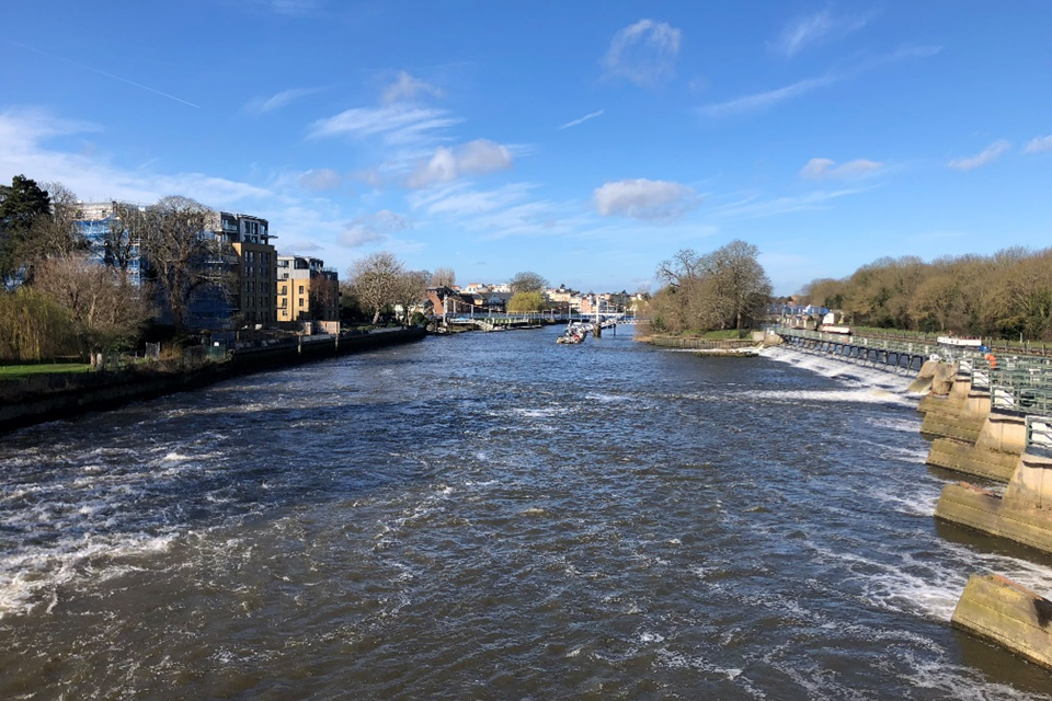
Image 1: The view from Teddington Weir looking downstream towards the lock.
3.3. Observed changes in flow levels
Analysis of datasets covering the last 30 years shows that 93% of the flows analysed have increased over that time. However, until we accumulate more data, we cannot tell whether these trends are due to natural variability in the data or a persistent long-term change. If these increases continue, this may affect the timing of when we need to upgrade flood defences upstream of the Thames Barrier.
Datasets over 50 years (or the best available record) show stronger evidence of persistent increases and decreases in about one-third of fluvial flows. These tributaries are heavily affected by man-made changes to the surrounding landscape and watercourses (such as weirs). These can greatly affect our ability to detect evidence of climate change. Increases or decreases in flow when comparing modern-day data with historic records may not relate to a proportional change in flood risk. For this reason, it is important that we fully understand why these changes have occurred.
3.3.1. Projections for future flows
The Environment Agency has updated national guidance for future flow projections since the Thames Estuary 2100 Plan was published. This guidance includes higher projections than those used in the Plan. The Environment Agency and Centre for Ecology and Hydrology are also due to publish further research on projections for fluvial flows in 2021. We will review this new guidance when deciding whether to update the deadlines in the Plan as part of the next phase of the 10-Year Review.
We currently operate the Thames Barrier during periods of high flows to help reduce flood risk to properties in the west London area. If high fluvial flow events start to occur more frequently than predicted in the Plan, we may need to close the Thames Barrier more often. This would require defences upstream of the barrier to be raised earlier, to reduce the average number of annual closures (see 5.3). The Plan proposes that using the Barrier to reduce fluvial flood risk in the west London area is phased out by 2035. This would reduce the average annual number of closures and help to keep them below the limit for as long as possible. This is important as higher closure numbers could impact our ability to maintain the reliability of the barrier for tidal flood events (see 5.4).
4. Condition of flood defences
4.1. Key findings:
- we monitor the condition of over 3000 fixed flood defences in the estuary - however, we are only responsible for maintaining 12% of these defences (39% by length of the defences)
- a range of organisations and land owners manage the remaining defences, and we work in partnership to ensure all defences are adequately maintained
- 97.5% of over 3000 fixed tidal defences in the estuary are classified as meeting or exceeding their target condition grade - compared to our target of 98%
- we will prioritise the 2.5% of defences that are below their required condition for maintenance through our asset management programmes
- we prioritise any of our defences that fall below their target condition for maintenance through our asset management programmes (including the current TEAM2100 programme) - and we will work with other defence owners to implement solutions
4.2. Why we monitor this indicator
We regularly monitor the condition of fixed tidal flood defences to understand whether defences are being effectively repaired, maintained, upgraded or replaced where required. We use condition grades from ‘1 (very good)’ to ‘5 (very poor)’ to indicate whether flood defences are in an appropriate state of repair. Condition grades are based on regular visual inspections. We aim to maintain at least 98% of flood defences at or above their required condition. This ensures that the flood defence system is resilient during a tidal flood event.
Over 3000 fixed flood defences (walls and embankments) work together to reduce tidal flood risk in the Thames Estuary. We are responsible for maintaining 12% of these flood defences (39% by length of the defences). The remaining 88% are managed by a range of organisations and landowners (Figure 4). It is important that we work in partnership with the other flood defence owners to ensure that the flood defence network is maintained to the required standard and condition.
If necessary, we can use powers provided through the Metropolis Management (Thames River Prevention of Floods) Amendment Act 1879 (MFA). These powers help us to ensure defences in London are maintained (HM Government, 1879). This applies from Teddington Lock to the River Darent on the south of the Thames, and to just short of Barking Creek on the north. This act provides the Environment Agency with powers to maintain the defences to a specified level and condition, if the defence owner does not. It also enables us to recover the costs from the defence owner. Outside of this area, the Environment Agency does not have express powers to force defence owners to complete maintenance works. However, we can request a contribution to the cost of works.
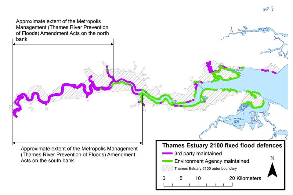
Figure 4: Maintenance responsibility for Thames Estuary 2100’s fixed flood defences - from Teddington to Shoeburyness and Sheerness.
On the north bank of the Thames, the majority of the tidal defences to the west of Aveley Bay are maintained by other individuals or organisations. To the east of Aveley Bay the majority are maintained by the Environment Agency. On the south bank of the Thames, the majority of the tidal defences to the west of Woolwich are maintained by other individuals or organisations. To the east of Woolwich the majority are maintained by the Environment Agency.
4.3. Current conditions of flood defences
97.5% of tidal flood defences in the Thames Estuary are classified as meeting or exceeding their required condition. At the time of the 5-Year Review, this figure was 98.6%. The network of flood defences continue to provide a high level of protection to London and the estuary. The majority of the defences in the estuary are in ‘good’ condition, but a proportion of them have a lower condition grade than 5 years ago. This may indicate that the flood defence network is deteriorating at a faster rate than anticipated when the maintenance programme was developed. This is likely to be due to the combined impacts of ageing assets and climate change. This finding is consistent with recent research by the Environment Agency. This research found that nationally, defences are deteriorating faster than previously thought (Impact of Climate Change on Asset Deterioration, Environment Agency, 2020).
When defences are below the required condition it does not necessarily mean that they are structurally unsafe, or that performance in a flood is compromised. Where defences are our responsibility, we will prioritise the 2.5% below their required condition for maintenance or repair through our asset management programme (TEAM2100). We will work with the relevant owners to maintain and repair the remaining assets in this category. We are also now developing our strategic approach to managing the overall decline in flood defence condition. This will help to determine when and where to invest in the estuary in future.
5. Thames Barrier operations
5.1 Key findings:
- the number of Thames Barrier closures varies greatly from year to year due to natural long-term tidal cycles and variations in weather conditions
- to date, there has been no statistically significant increase in annual closure numbers of the Thames Barrier - however, we expect that annual closure numbers will accelerate as sea level rise accelerates – this will make it easier to detect long-term changes in closure numbers due to sea level rise
- over the last 5 years, we have forecasted the high tide to within +/-0.2 metres for almost all high tides
- we will need to achieve within +/-0.2 metres accuracy for all high tides by 2040 - otherwise, we may need to raise defences upstream of the Barrier earlier than projected in the Plan
- the major flood barriers and gates in the estuary have a high standard of reliability overall (the ability to close when required)
- we will continue to invest in maintaining flood barriers and gates so that they will continue to provide the required standard of protection as barrier closure numbers increase due to rising sea levels
5.2. Why we monitor this indicator
Within this indicator, we monitor:
- how flood barriers in the estuary are operated over time, including how often they close each year
- the reasons for these closures
- how reliable the barriers are
- the accuracy of the forecasts we receive, that help us to decide when the barriers need to close
This information helps us to understand whether we should review the timing and type of flood risk management actions that the Thames Estuary 2100 Plan recommends.
5.3. Thames Barrier closures
As explained in 1.2, we need to keep the number of Thames Barrier closures within a manageable limit to maintain its reliability. This is currently set at an average of 50 per year. The more closures, the greater the risk of the Barrier not being able to operate as we need it to. There is also less time available for maintenance of the Barrier and for vessels to navigate through it. The number of Thames Barrier closures varies greatly from year to year due to natural long-term tidal cycles and variations in weather conditions. To date, there has been no statistically significant increase in annual closure numbers observed (Figure 5).
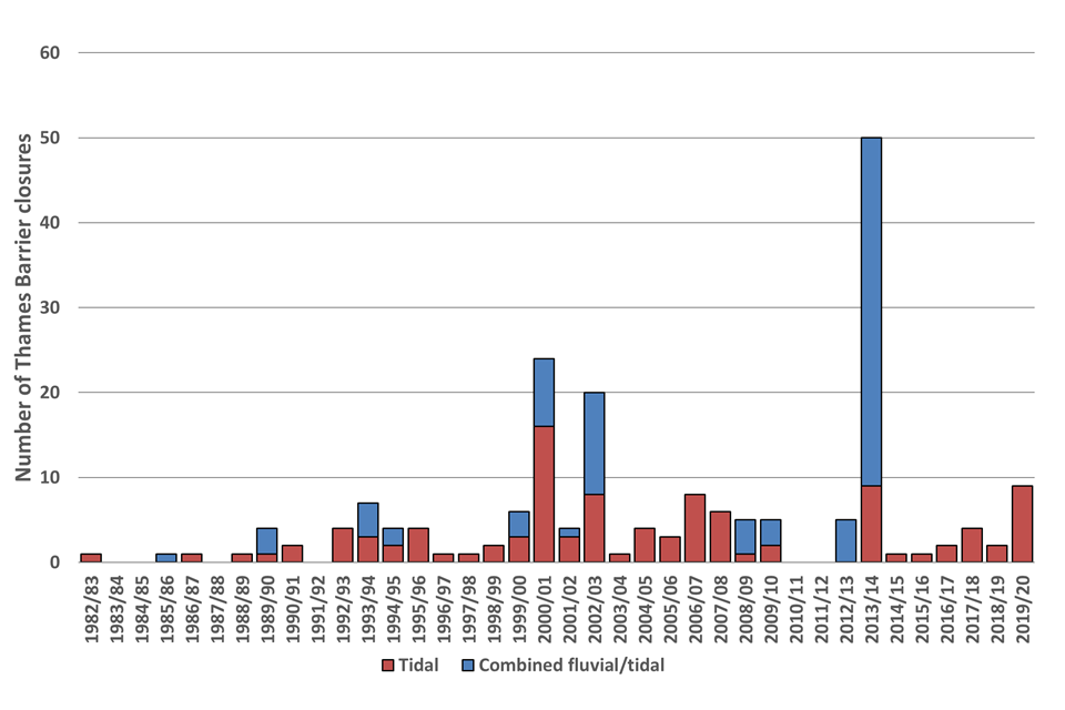
Figure 5: The number of Thames Barrier closures for flood defence purposes per year from its opening in 1982 until the 2019/20 closure year. Closure years run from mid calendar year to mid calendar year.
The last complete closure year was mid-2019 to mid-2020. Only 8 of the closure years had more than 5 Thames Barrier closures. Only 3 had more than 10. The years that had more than 10 were:
- mid-2000 to mid-2001 (24 closures)
- mid-2002 to mid-2003 (20 closures)
- mid-2013 to mid-2014 (50 closures)
The Plan includes projections of how many annual closures of the Barrier will be required on average in the future. The rate at which closure numbers increase is likely to accelerate in line with accelerating sea level rise. At present, the Thames Barrier is also used to help manage fluvial flood risk in the west London area. We will need to reduce reliance on the Barrier for this use, to help keep closure numbers within the manageable limit.
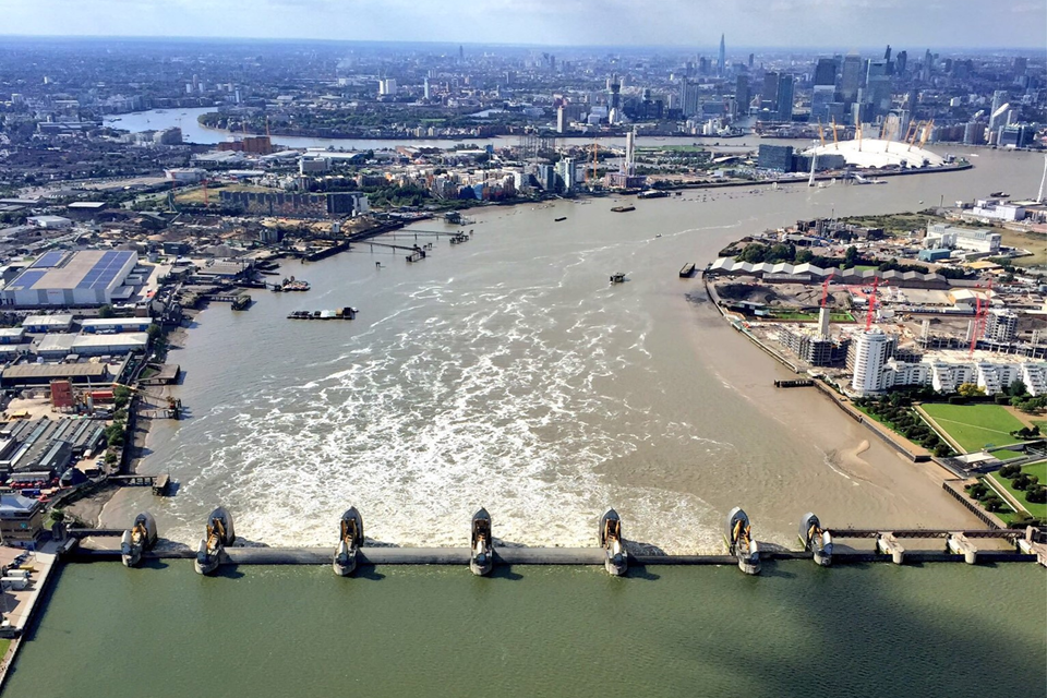
Image 2: An aerial view of the Thames Barrier with closed gates. Credit: National Police Air Service.
5.4. Forecasting accuracy
It is important that we forecast when we will need to close the Thames Barrier as accurately as possible. This helps to minimise precautionary closures. These are closures that are made when we are uncertain about whether water levels will reach the threshold for closing the Barrier. To reduce these risks, we include an allowance for a certain amount of error when deciding whether to operate the Barrier. The Plan assumes that by 2040, predicted tide levels will be accurate to within 0.2 metres of the actual tide levels. Projections for future Barrier closure numbers are based on this assumption. This can only be achieved via improvements in the accuracy of the forecasting.
Over the last 5 years, we have achieved this level of accuracy for almost all high tide forecasts. Our closure rules include a greater allowance for forecasting error, so it is not a concern that we are not achieving this accuracy every time. However, we do need to achieve this level of accuracy for all high tides by 2040. If we cannot reduce the number of precautionary closures, we may need to raise defences upstream of the Thames Barrier earlier than anticipated.
5.5. Barrier reliability
We regularly review the reliability of barriers in the estuary. This takes into account:
- the risk of human or forecasting errors during closures
- how reliable the barriers’ mechanics and electrical systems are
- how resilient the barriers are to internal risks (such as fires) and external risks (such as strikes by passing ships)
Assessments show that the reliability of the mechanical and electrical systems of the major flood barriers and gates in the estuary remains high overall. We will continue to invest in improvement works as annual closures increase due to rising sea levels. This means that these barriers will continue to provide the required standard of reliability. We are carrying out a programme of improvements to the Thames Barrier to ensure it is sufficiently reliable (to close when required) in the long-term This includes upgrading or replacing mechanical, electrical, forecasting and supporting systems.
As the Thames Barrier ages, it will require more frequent, and longer-duration maintenance work to ensure it continues to meet the required standard of reliability. We will need to work closely with our partners to discuss and agree any changes to how we operate the barrier. This will be key to managing the impact of longer-duration maintenance on navigation and river use. As part of the 10-Year Review, we will review our target reliability against new best practice guidelines for assessing the reliability of critical infrastructure.
6. People, property, critical infrastructure and policy
6.1. Key findings:
- the population in the Thames Estuary 2100 Plan area has increased by 14% since 2009 - from 1.25 million to 1.42 million
- the number of residential properties has increased by 17% since 2009 - from 500,000 to 586,000
- residential property value has increased by 61% since 2009 - from £200 billion to £321 billion
- the number of commercial properties recorded in the Plan area has increased by 39% since 2009 - from 40,000 to 55,640 (mostly due to an improvement in datasets)
- major critical infrastructure projects are planned or under construction in several areas covered by the Plan (Table 3)
- we will consider whether the flood risk management policies for areas including major critical infrastructure projects should be reviewed as part of the next phase of the 10-Year Review
- since the Plan was developed, new and updated national and local government policies generally show stronger support for the adaptive approach in the Plan - and its aims to deliver multiple benefits
- we are aiming to become a carbon neutral (net zero) organisation by 2030, which could affect how we construct flood defences in the future
- we will consider how to manage and monitor the carbon used in the implementation of the Plan as part of the wider 10-Year Review work
6.2. Why we monitor this indicator
The Thames Estuary 2100 Plan sets out recommended flood risk management policies for different areas of the estuary (known as Policy Units). These are based on the number of people, properties and critical infrastructure benefitting from the tidal flood defences in the area. Critical infrastructure includes energy, emergency and transport services. We update the flood risk management policies in the Plan based on these figures within each Policy Unit. We also take into account which locations in the estuary are likely to experience further development in the future. These areas may require an updated policy as a result of this development. This approach ensures that the policies recommended in the Plan enable us to manage the risk to people, properties and infrastructure in the Plan area.
We have also carried out a high-level review of new or updated government policies since 2009. This has enabled us to understand how they may affect our ability to deliver the Plan. It will also help us to ensure the updated Plan is consistent with current government policy. We will carry out a more detailed review of these policies as part of the wider 10-Year Review.
6.3. Growth in the Thames Estuary
The Plan assumes that the number of people and residential properties at risk of tidal flooding in the Plan area will increase over time. The increases in Table 2 are in line with this assumption. Projections for future population growth do not currently include the impact of the global Coronavirus pandemic or potential changes due to the United Kingdom leaving the European Union. The long-term effects of these 2 events are currently unknown.
Table 2: Changes in numbers of people, property and infrastructure in the Plan area since the Plan was developed.
| Original Plan (2009 data) | 5-Year Review (2014 data) | 10-Year Review (2018 data) | |
|---|---|---|---|
| Estimated population | 1.25 million | 1.34 million | 1.42 million |
| Residential property numbers | 500,000 | 551,000 | 586,000 |
| Residential property value | £200 billion | £275 billion | £321 billion |
| Commercial property numbers* | 40,000 | 40,500 | 55,640 |
For commercial property numbers, a significant proportion of this increase is due to an improvement in datasets, which have replaced unclassified buildings with commercial classifications.
‘Critical infrastructure’ describes assets that support or provide essential services for daily life. Major critical infrastructure projects are planned or under construction in several areas of the Thames Estuary 2100 Plan (see Table 3). We will consider whether the flood risk management policies for these areas should be reviewed as part of the next phase of the 10-Year-Review.
Table 3: Major critical infrastructure projects in the Thames Estuary 2100 Plan area.
| Project | Location | Project type |
|---|---|---|
| Thames Tideway Tunnel | Acton (West London) to Abbey Mills Pumping Station, Mill Meads (East London) | Wastewater tunnel |
| Silvertown Tunnel | Silvertown to North Greenwich (East London) | Road tunnel |
| Riverside Energy Park | Bexley (East London) | Renewable energy facility |
| Lower Thames Crossing | Between Gravesend (Kent) and Tilbury (Essex) | Road tunnel |
| Tilbury2 | Tilbury | Port facility |
| Thurrock Flexible Generation Plant | Thurrock | Power plant |
6.4. Changes in government policy
Since 2009, new and updated national and local government policies generally show stronger support for the adaptive approach in the Plan. There is also evidence for stronger support of the Plan’s aims to deliver multiple benefits. This increased support could reflect the increase in awareness of the impacts of climate change since the Plan was developed.
We will continue to work with our partners to incorporate the Plan’s recommendations further into strategic and local plans. This will strengthen support for delivering the Thames Estuary 2100 Plan within the planning system. We will also review updated policies in more detail as part of the wider 10-Year Review. This will help us to understand where we need to do further work with partners to optimise the benefits that the Plan could deliver.
We are aiming to become a carbon neutral organisation by 2030, 20 years earlier than the government’s target of 2050. This may affect the options for how we construct flood defences and carry out other works in the future. We will consider how to manage and monitor the carbon used in the implementation of the Plan as part of the wider 10-Year Review work.
7. Erosion and deposition
7.1. Key findings:
- erosion is occurring across the Thames Estuary
- deposition is occurring in certain areas of the estuary - predominately upstream of Vauxhall Bridge in the inner estuary and downstream of Mucking Flats in the outer estuary
- it is important that we detect and remedy any impacts to flood defences as early as possible, so we will enhance inspections at sites where we know erosion is occurring
- overall, these changes are in line with the Plan’s expectations - however, we may need to extend our monitoring of erosion and deposition to better understand the causes of these processes
- improving our understanding of the causes of these processes will help us to improve how we manage any impacts in future
7.2. Why we monitor this indicator
Erosion and deposition are natural processes. Erosion removes sand, shingle, mud and other material from the foreshore and bed of the River Thames before transporting it through the estuary to the sea. Some of this removed material accumulates in other parts of the estuary (deposition). We monitor how and where these processes are happening in the estuary, as they can affect flood defences. Erosion can expose the foundations of fixed flood defences leaving them vulnerable to further damage (Image 3). Deposition, on the other hand, can obstruct the operation of active flood defences. Areas of habitat can also be affected, with erosion reducing habitat in some areas and deposition creating habitat in others.
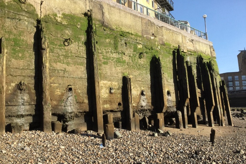
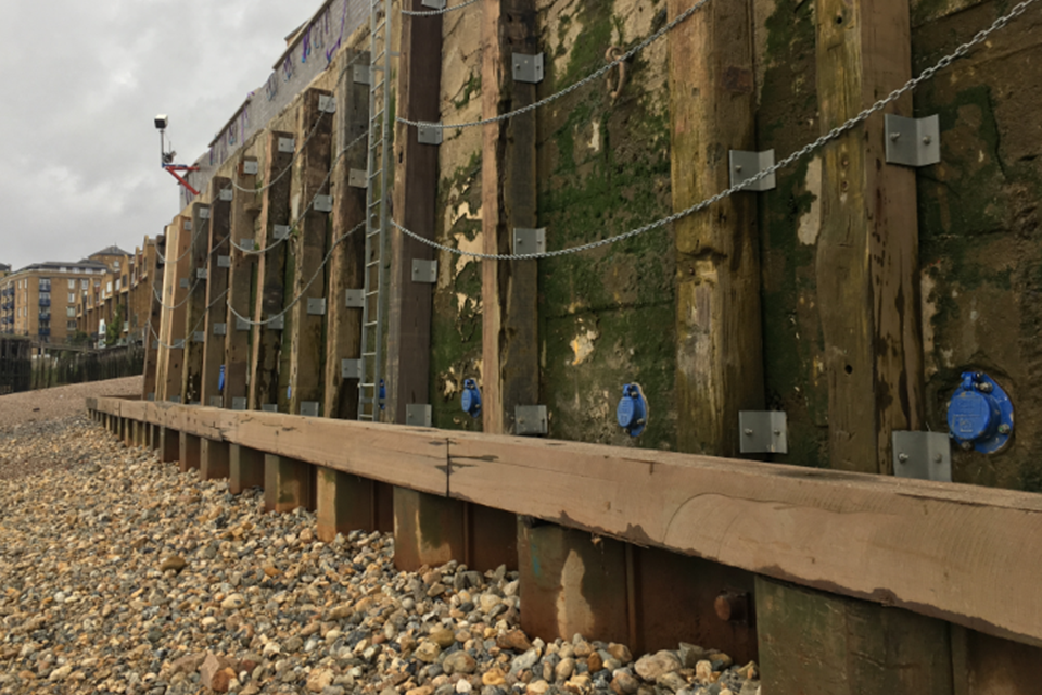
Image 3: (Top) erosion of flood defences at Dukeshore Wharf, (bottom) completed flood defence improvements.
7.3. Rates of erosion and deposition
Our analysis shows that erosion is occurring across the estuary, whereas deposition is occurring in localised areas. These areas are predominately upstream of Vauxhall Bridge in the inner estuary and downstream of Mucking Flats in the outer estuary. The outer estuary data in particular shows a trend of large losses of material. These trends are likely to be heavily influenced by the disturbance of sediment caused by dredging activities. Overall, these changes are in line with the expectations in the Plan.
7.4. Flood defence inspections
Monitoring trends in erosion and deposition tells us where these processes are occurring, but does not tell us how this is affecting flood defences. We monitor the impacts on flood defences by carrying out regular visual inspections. Identifying these trends can help us to plan which areas of the estuary require enhanced inspections, to ensure that we can mitigate the impacts as early as possible. It can also help to inform future flood defence design and habitat creation programmes.
We have already started a programme of enhanced monitoring across part of the estuary. This enhanced monitoring includes using new technology to detect three-dimensional data via aircraft, drones and boat surveys. This assists us in identifying areas at risk. We are carrying out studies to determine which areas are being impacted the most by these processes as part of our current asset management programme (TEAM2100). We are also working with the Port of London Authority to develop projects that will help us better understand the drivers of foreshore change. We may need to expand this monitoring to improve understanding of the causes of erosion and deposition, and reduce impacts on defences.
8. Habitat
8.1. Key findings:
- there has been a natural 2.5% increase in intertidal habitat in the Thames Estuary from 2012 to 2018 (excluding habitat created by compensation schemes)
- the area of saltmarsh in the estuary has naturally increased by 6%
- we have worked with the RSPB to create compensatory habitat at Wallasea Island (Essex), and DP World London Gateway to create compensatory habitat at Salt Fleet Flats Reserve (Kent) - together, these schemes compensate for habitat losses projected in the Plan by 2025 (58 hectares)
- we have reviewed and updated projected habitat losses in the Plan due to coastal squeeze - the new figure in the Plan for habitat losses by 2105 is 598 hectares
8.2. Why we monitor this indicator
A core aim of the Thames Estuary 2100 Plan is to enhance and restore ecosystems in the estuary. We must also comply with the Conservation of Habitats and Species Regulations 2010. Monitoring the amount of protected intertidal habitat (saltmarsh and mudflat) means that we can assess how much habitat is lost. This allows us to create sufficient amounts of compensatory habitat before it is lost due to coastal squeeze. Coastal squeeze occurs when habitats are lost because flood risk management (for example,hard flood defences) prevent the natural landward movement of habitats. Compensation in these cases normally involves creating new habitat.
8.3. Changes in habitat
We used aerial surveys and geographic information software to identify changes in areas of Natura 2000 designated habitat. The surveys showed that the area of saltmarsh has increased by 6%, and the total intertidal area has increased by 2.5%. This excludes areas created by compensation schemes. Despite these increases in habitat, we still need to plan for future habitat compensation, as these may be natural short-term variations, rather than long-term changes.
2 new areas of intertidal habitat have been created since the Plan was published, which compensate for 58 hectares of projected losses by 2025. These are located at Salt Fleet Flats Reserve (Image 4) within the Plan area (Kent), and Wallasea Island, which is outside the Plan area (Essex). Creating compensatory habitat outside the estuary was the most cost effective solution and was consistent with the approach used for other major projects.
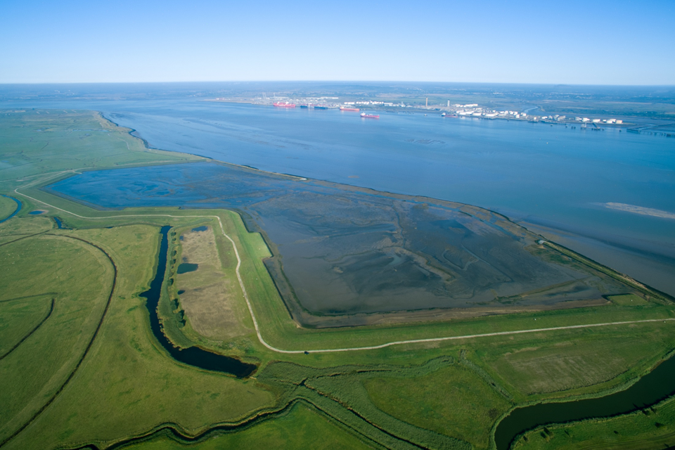
Image 4: Aerial view of compensatory habitat created at Salt Fleet Flats Reserve, Kent.
A ‘natural capital approach’ to policy and decision-making considers the value of the natural environment for people and the economy. ‘Biodiversity net gain’ is an approach that aims to leave the natural environment in a measurably better state than beforehand. We are currently developing methodology to assess natural capital and biodiversity net gain. Therefore, these principles have not been included in this review. However, we will take policy changes on biodiversity net gain and carbon neutrality into account when we update the Plan. This will enable us to reflect changes in sustainability targets since we first published the Plan. We will capture data to support a future assessment of natural capital and biodiversity net gain. We will integrate this into the monitoring for the 15-Year Review in 2025.
8.4. Updated projections for future habitat losses
We have worked with Natural England to review the figures for the amount of predicted Natura 2000 designated habitat losses due to coastal squeeze. We have therefore adjusted the amount of compensatory habitat required in the Plan. Table 4 shows the revised figures based on our review of the original habitat loss modelling. The revised total projected Natura 2000 designated habitat loss in the Thames Estuary due to coastal squeeze is 598 hectares by 2105.
Table 4: Revised figures of projected Natura 2000 designated habitat losses due to coastal squeeze. Note: time periods are aligned with Shoreline Management Plans (which address compensatory habitat requirements for the rest of England’s coastal habitats).
| Years | Predicted change in habitat (hectares) |
|---|---|
| 2006 to 2025 | -58 |
| 2026 to 2055 | -45 |
| 2056 to 2105 | -495 |
| Total | -598 |
As habitat losses occur over long timescales, we cannot yet tell whether these predicted losses have started to occur. After 2025, we will be able to update the modelling and review the predicted changes shown in Table 4.
9. Social, cultural and commercial value
9.1. Key findings:
- there are approximately 3000 ‘social assets’ and 27 km² of open green space in the Thames Estuary 2100 Plan area
- the Plan area contains some of the most socially deprived areas of England, and there are opportunities to enhance these areas through the ‘riverside strategy approach’ - this involves integrating flood defence upgrades into wider redevelopment and social, cultural and commercial enhancement of the riverside environment
- we are developing 2 riverside strategy pilot projects with Newham and the City of London local councils
- the estuary’s flood defence system protects 4 World Heritage Sites and over 4000 listed buildings
- the number of recorded passenger journeys on boats in the estuary increased from 1.57 million per year in 2000/2001 to 10.01 million per year in 2017/2018 - this is in part due to improved methods for counting passenger numbers and the addition of the Woolwich Ferry to monitored routes
- the type of cargo transported has changed, but the amount of cargo transported annually is similar to the start of this century
9.2. Why we monitor this indicator
It is important that we assess changes in the social value of the estuary. This enables us to understand whether the Plan is meeting its aims to protect and enhance the social, cultural and commercial value of the estuary. For monitoring purposes, we define ‘social assets’ as those that have an impact upon the population’s health and wellbeing (such as education and community facilities).
Monitoring the number of social, cultural and commercial assets within the Plan area provides a baseline of available data from which we can compare changes. We have counted the number of social assets within the Plan area for the first time since the Plan was developed.
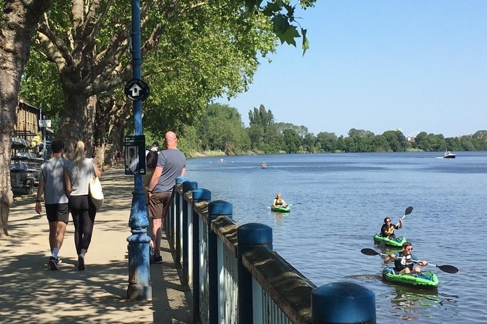
Image 5: Putney embankment in summer, 2020.
9.3. Social value
The Thames Estuary 2100 Plan area contains:
- 72 arts centres
- 15 cinemas
- 88 community centres
- 14 night clubs
- 380 pubs
- 66 theatres
- 496 education facilities
- 815 leisure sites (libraries, amusements, museums, galleries, leisure centres)
- 547 places of worship
- 275 public parks and gardens (15 km²)
- 27 km² of open green space (allotments, religious grounds, sports fields, public parks and gardens)
- 31 residential mooring sites
- 171 sports and recreation clubs
The ‘riverside strategy approach’ advocates early planning so that upgrades to defences can be integrated into wider redevelopment and enhancement of the riverside. We are developing riverside strategy pilot projects with Newham and City of London local councils. Both of these councils are within the top 3 population groupings for social deprivation (Consumer Data Research Centre, 2020).
9.4. Cultural value
‘Cultural assets’ include listed buildings, archaeological sites, and registered parks and gardens. Within the Plan area, there are:
- 4 World Heritage Sites
- over 4,000 listed buildings
- 69 scheduled monuments
- 48 registered parks and gardens
One hundred and seventeen of these sites are ‘under threat as a result of neglect, decay or inappropriate development’.
We monitor the number of designated heritage sites in the Plan area and their locations. This is because a heritage site could have legal obligations (for example, to protect its setting) that we may need to consider when implementing defence upgrades. The estuary’s flood defence system protects the majority of heritage sites in the Plan area. It is important that critical works to flood defences in the area of these sites have minimal impact on them. The presence of a heritage site could influence the type of defence and working methods required. It will also require careful planning and consultation with the relevant stakeholders to minimise any impact.
9.5. Commercial value
The estuary is an important part of London’s transport network, for both passengers and commercial cargo. Passenger journeys include:
- commuter boats
- sightseers on charter boats
- other passenger vessels
It is important that we consider the impact of flood defence improvements on both passenger vessel and commercial shipping routes when reviewing the Plan’s recommendations. They will also influence the operation of any future barriers that may be required as part of improvements to the flood defence system.
The number of passenger journeys on the Thames recorded by Transport for London has increased. In 2000/2001, there were 1.57 million journeys per year. In 2017/2018, there were 10.01 million journeys per year (Transport for London data published in Greater London Authority, 2019). This includes increases due to the inclusion of additional services (Woolwich Ferry) and improved monitoring. There have also been real-world increases due to:
- improved marketing
- the introduction of contactless payment
- additional piers at Plantation Wharf and Battersea Power Station
- pier extensions at Bankside and Westminster
- increased signage and information provision
The Port of London Authority (PLA) is currently carrying out studies to project likely usage of the river until 2050. The PLA will publish the results of these studies in summer 2021. We will work with the PLA to incorporate these results into our decision-making when updating the Plan.
Our monitoring has also highlighted that the type of cargo transported on the estuary has changed. However, the total mass of cargo transported annually is similar to the start of this century. This is true both on the Thames as a whole and in Greater London (Port of London Authority, 2018).
9.6. Assessment of wider benefits
The 10-Year Review includes a separate report to assess wider benefits that the Plan could deliver (‘Assessment of delivery of wider benefits’). This report will look at whether the Plan is meeting its aim to protect and enhance the social, cultural and commercial value of the estuary.
10. Public and institutional attitudes to flood risk
10.1. Key findings:
- in an online survey, we asked, ‘Compared to 10 years ago, do you feel tidal flood risk and climate change have become more or less important issues within your organisation?’ - 70% of organisations and businesses that responded to this question said that tidal flood risk is ‘more important’ and 96% said that climate change is ‘more important’ (Environment Agency online survey, 2020)
- when asked ‘How important is managing the issue of climate change to your organisation?’, 92% of businesses and organisations that responded to this question said ‘very – extremely important’ to them
- when asked ‘Thinking about the communities you work with, compared to 10 years ago, do you feel tidal flood risk and climate change have become more or less important to them?’, 46% of businesses and organisations that responded to this question said tidal flood risk had become ‘more important’ and 80% said that climate change had become ‘more important’
- many organisations were supportive of alternative options to raising hard flood defences, such as natural flood management - they also recognise the limitations in certain locations within the estuary (Environment Agency online survey, 2020)
- we will reschedule a survey to measure ‘public attitudes to tidal flood risk’ (cancelled due to the Coronavirus pandemic) at an appropriate time in the future
- data from the 2019 national flood survey shows that there has been little change in awareness and acceptance of flood risk since 2014 - however, the number of people who agree it is their personal responsibility to protect their home has increased (75% in 2019 from 60% in 2014)
10.2. Why we monitor this indicator
We monitor attitudes to managing tidal flood risk to improve our understanding of current levels of awareness. This informs how we work collaboratively with our partners, and how we plan future engagement with organisations and communities in the estuary. Partnership working is a critical factor in enabling us to successfully deliver the Thames Estuary 2100 Plan. This information is also useful for identifying preferences for flood risk management options and assessing the effectiveness of flood warnings.
10.3. Public attitudes to flood risk
We intended to conduct approximately 300 face-to-face interviews with residents from across the Plan area. We would have used this data as a baseline from which we could assess changes in public attitudes over time. Due to the Coronavirus pandemic, we could not carry out this research. We collected limited data on public attitudes from an online survey (summer 2020) for our partners, organisations, and members of public in the Plan area. However, this was not enough data to use as a representative sample for monitoring public attitudes. We are planning to reschedule the cancelled interviews with Thames Estuary residents at an appropriate time in the future.
We carry out national flood surveys annually, which provide a picture of how attitudes to flood risk have changed nationally. Comparing results from the 2013 to 2014 national flood survey with the 2018 to 2019 survey, awareness and acceptance of flood risk has remained relatively consistent. 39% of respondents believed their property was either ‘definitely’ or ‘possibly’ at risk of flooding in 2019, compared to 45% in 2014. Preparedness of those at risk increased from 62% in 2013 to 69% in 2014, however, in 2019, this figure only increased to 70%. 60% of respondents acknowledged it was their responsibility to take action to protect their home from flooding in 2014. In 2019, 75% disagreed or strongly disagreed with the statement ‘it’s not really my responsibility to make efforts to reduce the risk of flooding in my home’.
It is positive that more people agree they need to take personal responsibility to make efforts to protect their homes. However, it is evident that we need to increase the effectiveness of campaigns to raise awareness of and preparedness for flood risk nationally. This is likely to be the case within the Thames Estuary too. Given the impacts of climate change on flood risk, the Plan acknowledges the importance of promoting public awareness of tidal flooding in the estuary.
10.4. Institutional attitudes to flood risk
Institutional attitudes to flood risk are the attitudes of organisations or groups, as opposed to individuals giving their personal views. Institutions who responded to the online survey in summer 2020 included:
- councils
- regional authorities (such as county councils)
- developers
- infrastructure providers
- charities and special interest groups
- river user groups
When asked, ‘How important is managing the issues of tidal flood risk and climate change to your organisation?’
- 83% of organisations told us that managing tidal flood risk is ‘very – extremely important’
- 92% said that managing the impacts of climate change is ‘very – extremely important’
Both issues have become increasingly important within organisations over the last 10 years (Figure 6). This trend was also evident when we asked organisations if they felt that these issues had changed in importance for the communities they work with (Figure 7). We recognise the need to do more engagement work with organisations and communities to improve understanding of climate change impacts in the estuary. We also aim to improve understanding of how the Thames Estuary 2100 Plan could manage these impacts in the future.
This graph shows the percentage of respondents who answered the survey question, ‘Compared to 10 years ago, do you feel tidal flood risk and climate change have become more or less important issues within your organisation?’
| Change in Importance | Tidal flood risk (% of respondents) | Climate change (% of respondents) |
|---|---|---|
| Less Important | 0 | 0 |
| About the same | 26 | 2 |
| More important | 70 | 96 |
| Unsure | 4 | 2 |
Figure 6: Perceived changes in importance of (a) tidal flood risk and (b) climate change within organisations over the last 10 years.
This graph shows the percentage of respondents who answered the survey question, ‘Thinking about the communities you work with, compared to 10 years ago, do you feel tidal flood risk and climate change have become more or less important to them?’
| Change in Importance | Tidal flood risk (% of respondents) | Climate change (% of respondents) |
|---|---|---|
| Less Important | 0 | 0 |
| About the same | 39 | 9 |
| More important | 46 | 80 |
| Unsure | 11 | 7 |
| Do not work with communities | 4 | 4 |
Figure 7: Perceived changes in importance of (a) tidal flood risk and (b) climate change within communities that organisations work with over the last 10 years.
When asked about flood risk management options, the survey results show that organisations prefer natural flood management to traditional hard engineering (Figure 8). However, they recognised that the most appropriate method of flood risk management depends on the specific location in the estuary where it is required.
Respondents were asked to ‘rank the possible options or strategies for managing tidal flood risk in the Thames Estuary, in order of preference.’ This graph shows the average combined ranking of options.
| Flood risk management option | Average combined ranking |
|---|---|
| Natural flood management | 4.83 |
| Flood storage | 3.65 |
| Public spaces which can be safely flooded | 3.61 |
| Raising defences by up to 1 metre | 3.39 |
| Moving defences inland to make space for water (managed realignment) | 3.33 |
| Raising defences more than 1 metre | 2.93 |
| Relocating homes and businesses | 1.37 |
Figure 8: Average ranking of preferred flood risk management options for managing tidal flood risk in the Thames Estuary, by respondents who completed the online survey ‘Thames Estuary 2100: Updating the Plan.’
Conclusion
Our monitoring shows that there have been changes in the Thames Estuary over the last 10 years, as anticipated when the Thames Estuary 2100 Plan was developed.
These changes could have an impact on how we manage tidal flood risk in the future. This shows the importance of ongoing monitoring to assess change in the estuary and improve our understanding of what these changes mean for its future.
Next steps for the 10-Year Review
The outputs from this review, combined with other studies, will enable us to review the recommendations for managing tidal flood risk in the Plan. The Plan anticipated that sea level in the estuary would rise, due to climate change. The acceleration in the rate of sea level rise in our findings is similar to the Plan’s original projections. The adaptive nature of the Plan means that we use the most up-to-date scientific guidance and data. Therefore, we will update the projections in the Plan to use the higher scenario from the new climate change projections (UKCP18). We will also update the baseline from which the sea level rise projections are calculated.
As sea level rise continues to accelerate, we expect to close the Thames Barrier more frequently. We will therefore continue to monitor closure numbers. We will consider a new method for forecasting future numbers of Thames Barrier closures that considers fluvial flow and other parameters (for example, sea level rise). This will help us to keep average closure numbers within a manageable limit by helping us set accurate deadlines for raising defences upstream of the Barrier. We will also continue to invest in maintaining the estuary’s flood defences so that they will continue to provide the required standard of protection.
We are carrying out several other technical studies as part of the 10-Year Review. These include:
- a review of how much allowance to include in flood defence design to account for uncertainty on extreme wave heights
- updating our modelling of how water moves up the estuary during a storm tide
We will use the results of these studies, alongside updated sea level rise projections, to update the Plan’s deadlines for upgrading tidal flood defences.
It is significant that the Thames Estuary’s flood defence system is now protecting more people and property than ever before. We will review any areas of the estuary likely to experience further development to assess whether they require an updated flood risk management policy.
In addition, we are also:
- working with our partners to map the social, cultural, environmental, and economic benefits that the Thames Estuary 2100 Plan can deliver
- reviewing the lessons learnt in the first 10 years of delivering the Thames Estuary 2100 Plan
These pieces of work will help us to review the recommendations for managing tidal flood risk in the Thames Estuary, in conjunction with updating the deadlines.
Figure 9 illustrates how these pieces of work will feed into the review of recommendations.
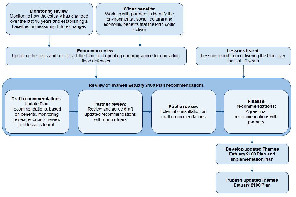
Figure 9: The 10-Year Review programme.
The updated recommendations for managing tidal flood risk will form the basis of the revised Thames Estuary 2100 Plan. We will be working with our partners to develop these, before going to a public consultation.
We will publish the updated Thames Estuary 2100 Plan in 2022.
Immediate next steps
The findings highlight further actions that we need to take to manage flood risk. We will be prioritising defences that are below their required condition for maintenance through our TEAM2100 asset management programme. For any defences that we do not own and maintain, we will work with other owners to determine and implement the right solutions. We will carry out enhanced inspections in locations where we know erosion is occurring to detect and remedy any impacts on defences as soon as possible.
We will also identify which areas of the estuary require future investment in flood defences and when we need to invest.
We recognise that we need to review measures to increase the effectiveness of flood campaigns. This includes engagement work with the public on the potential impacts of climate change in the estuary.
Learning from the adaptive approach
Our findings have identified that we need to collect longer datasets for some parts of our monitoring programme. This will improve our understanding of how and where permanent change is occurring. In some cases, natural variations in data make it difficult to detect long-term changes. For this reason, we will continue to monitor trends in river flows and areas of habitat to build on the overall picture of change.
We already monitor parts of the estuary to determine where erosion and deposition are occurring. However, we may need to extend this to cover a wider area to improve our knowledge of the drivers behind these processes. We will continue to be better equipped to manage the impacts of rising sea levels and climate change as we collate more data and review updated guidance.
The Thames Estuary 2100 Plan aims to do more than manage flood risk; it aims to enhance the estuary’s social, cultural and commercial value We will continue to monitor changes in the number of social and cultural assets in the Plan area to ensure the Plan meets this aim. We will also incorporate data on projected future use of the river for passenger and commercial vessels.
We will also capture data to support a future assessment of natural capital and biodiversity net gain. We will integrate this data into the monitoring for the 15-Year Review in 2025.
Organisations and communities in the estuary feel that managing climate change and tidal flood risk has become more important over the last 10 years. Biodiversity net gain and carbon neutrality have also come to the forefront. We will take policy changes on these topics into account when updating the Plan to reflect the latest sustainability targets. Policies are changing to reflect this at both a local and national level. We will continue to work with our partners to optimise the benefits that the Plan could deliver. We will also encourage them to incorporate its recommendations and benefits into their plans and strategies.
Creating a resilient Thames Estuary
The Thames Estuary 2100 Plan takes an adaptive approach to managing climate change, but this does not mean that we can stop mitigating the causes. The climate emergency must and will remain at the forefront of our minds. This starts with our ambition to be carbon neutral by 2030, 20 years ahead of the UK Government target.
We recognise that we can only achieve the objectives of the Plan if we work in partnership with other risk management authorities and riparian owners. This aim is at the core of the 10-Year Review and the updated Plan.
We will continue to work with our partners to strengthen our ability to adapt and respond to flooding and coastal change. To make the right investment decisions to support sustainable growth we must work together. With our partners’ support, we can continue to protect and enhance the estuary for all within it, create a resilient Thames Estuary that is fit for future generations.
References
Consumer Data Research Centre (2020) Index of multiple deprivation (IMD), Consumer Data Research Centre. Available at: https://data.cdrc.ac.uk/dataset/index-multiple-deprivation-imd (Accessed: 30 October 2020).
Defra (2006) Flood and Coastal Defence Appraisal Guidance. FCDPAG3 Economic Appraisal. Supplementary Note to Operating Authorities – Climate Change Impacts. October 2006. London, UK: Defra, p. 9. Available at: http://www.sdcg.org.uk/Climate-change-update.pdf.
Environment Agency (2012) Thames Estuary 2100 Managing flood risk through London and the Thames Estuary TE2100 Plan. London, UK: Environment Agency, p. 230.
Environment Agency (2016) TE2100 5 Year Monitoring Review. London, UK: Environment Agency, p. 69.
Environment Agency (2019) Coastal flood boundary conditions for the UK: update 2018. SC060064/TR6. Bristol, UK: Environment Agency, p. 116.
Environment Agency (2019) Flood risk assessments - climate change allowances, gov.uk. Available at: https://www.gov.uk/guidance/flood-risk-assessments-climate-change-allowances (Accessed: 5 February 2020).
Environment Agency (2020) EA2025 Creating a better place. London, UK: Environment Agency, p. 24. Available at: https://assets.publishing.service.gov.uk/government/uploads/system/uploads/attachment_data/file/899042/EA2025-creating-a-better-place.pdf.
Environment Agency (2020) Flood and coastal risk projects, schemes and strategies: climate change allowances, gov.uk. Available at: https://www.gov.uk/guidance/flood-and-coastal-risk-projects-schemes-and-strategies-climate-change-allowances (Accessed: 23 July 2020).
Environment Agency (2020) Impact of climate change on asset deterioration. SC120005/R1. Bristol, UK: Environment Agency, p. 52.
Environment Agency (2020) National Flood and Coastal Erosion Risk Management Strategy for England. London, UK: Environment Agency, p. 148.
Environment Agency (2020) Thames Estuary 2100: Updating the Plan. Thames Estuary 2100 online survey Jun-Jul 2020. Available at: https://consult.environment-agency.gov.uk/london/thames-estuary-2100-updating-the-plan (Accessed 11 February 2021).
Environment Agency (2021) What is coastal squeeze? Available at: https://www.gov.uk/government/publications/what-is-coastal-squeeze (Accessed: 11 February 2021).
Greater London Authority (2019) London Plan Annual Monitoring Report 15 2017/18. London, UK: Greater London Authority, p. 189.
Greater London Authority (2020) The London Plan - The publication London Plan. London: Greater London Authority, p. 615. Available at: https://www.london.gov.uk/what-we-do/planning/london-plan/new-london-plan/publication-london-plan (Accessed: 3 February 2021).
Haigh, I. D., Inayatillah, A. and Radtke, H. (2020) Sea level analysis to inform the Thames Estuary 2100 Plan - 10-Year Review. Southampton, UK: University of Southampton, p. 50.
Historic England (nd) Historic England - Listing data download area. Available at: https://services.historicengland.org.uk/NMRDataDownload/default.aspx (Accessed: 1 August 2019).
HM Government (1879) Metropolis Management (Thames River Prevention of Floods) Amendment Act 1879 chapter 198. Available at: https://www.legislation.gov.uk/ukla/1879/198/enacted (Accessed: 26 January 2021).
HM Government (2018) 25 Year Environment Plan. London, UK: HM Government, p. 151.
IPCC (2019) Summary for Policymakers. In: IPCC Special Report on the Ocean and Cryosphere in a Changing Climate. IPCC, p. 36.
Met Office (2018) About UKCP18, About UKCP18. Available at: https://www.metoffice.gov.uk/research/collaboration/ukcp/about (Accessed: 12 July 2019).
Met Office (2018) UKCP18 Guidance: Representative Concentration Pathways. Devon, UK: Met Office, p. 3.
Met Office (2019) UKCP18 Science overview report November 2018 (updated March 2019). London, UK: Met Office, p. 73.
Palmer, M. et al. (2018) UKCP18 Marine report. Hadley, UK: Met Office, p. 132.
Planning Inspectorate (2019) National Infrastructure Planning, National Infrastructure Planning. Available at: https://infrastructure.planninginspectorate.gov.uk.
Port of London Authority (nd) Thames Vision interactive map. Available at: http://www.pla.co.uk/About-Us/The-Thames-Vision/Thames-Vision-Interactive-Map (Accessed: 1 August 2019).
Port of London Authority (2018) Environment report. London, UK: Port of London Authority, p. 10.
Port of London Authority (2018) Investing in the future - Annual report and accounts 2018. London, UK: Port of London Authority, p. 96.
UK Centre for Ecology and Hydrology (2020) National River Flow Archive, National River Flow Archive. Available at: https://nrfa.ceh.ac.uk (Accessed: 3 August 2020).
UKCP18 (2018) UKCP18 Datasets, UKCP18 Products. Available at: https://ukclimateprojections-ui.metoffice.gov.uk/products (Accessed: 26 November 2018).
Contact
To request the Technical Monitoring Report, or for general enquiries, please email:
ThamesEstuary2100@environment-agency.gov.uk
Thames Estuary 2100 logo.