Registers of Scotland data
Updated 22 December 2023

© Crown copyright 2023
This publication is licensed under the terms of the Open Government Licence v3.0 except where otherwise stated. To view this licence, visit nationalarchives.gov.uk/doc/open-government-licence/version/3 or write to the Information Policy Team, The National Archives, Kew, London TW9 4DU, or email: psi@nationalarchives.gov.uk.
Where we have identified any third party copyright information you will need to obtain permission from the copyright holders concerned.
This publication is available at https://www.gov.uk/government/statistics/quality-assurance-of-administrative-data-in-the-uk-house-price-index/registers-of-scotland-data
1. Introduction
This Quality Assurance of Administrative Data document relates to administrative data used in the UK House Price Index (HPI). The UK House Price Index is a National Statistic that shows changes in the value residential properties in the UK. The UK HPI is a joint production by HM Land Registry, Land and Property Services Northern Ireland, Office for National Statistics and Registers of Scotland. This document relates to the Scottish data that feeds into the UK HPI. RoS also publish other house price statistics and a separate QAAD relating to these outputs can be found here.
RoS administrative data is one of a number of administrative datasets that are used in the production of the publication. RoS house price data is matched to other property characteristics, such as room numbers and floor space (currently obtained from Energy Performance Certificate data) and the type of neighbourhood where the property is situated (defined by the ACORN classification from CACI Ltd). Separate quality assurance has been undertaken on these other administrative datasets by the Office for National Statistics (ONS).
2. Data sources
The following table shows the data sources, their risk of quality concerns and public interest profile. Further information about these classifications are available in the UK Statistics Authority’s Quality Assurance of Administrative Data guidance.
| Data Type | Administrative Source | Data Quality Concern | Public Interest Profile | Matrix Classification |
|---|---|---|---|---|
| Land register data | Registers of Scotland | Medium | Medium | A2 |
| Map data[1] | Ordnance Survey | Medium | Medium | A2 |
The data quality concern attached to the RoS land register data is considered to be a medium concern. This is because the data is extracted from applications for registration in the Land Register. The data is submitted by standard land register application forms, deeds and accompanying plans (if required). The risk of inaccurate data being submitted, and of inaccuracies being created by errors in the land registration process, is inherent but is mitigated by the following: checks done by solicitors; by pre-application reports being provided by RoS prior to solicitors submitting applications; by data being taken by RoS directly from digital applications, removing the need to re-capture key data and simplifying and streamlining the data entry process; by RoS registration officers conducting registration checks; by the RoS Quality Team undertaking quality checks; and by the RoS Land & Property Data Team undertaking quality assurance on the data.
In relation to the map data, the quality concern is considered to be medium. The risk of quality concerns within the Ordnance Survey data itself is low because there is clear agreement about what data is provided via the Public Sector Geospatial Agreement (PSGA), when and how it will be updated, and the quality of the data meets our statistical needs. The Ordnance Survey map data is used as a tool within our house type methodology and is used to support the classification of sales within a specific house type. It is often this methodology and our internal processes rather than the map data itself that can cause inaccuracies or omissions, but again these are mitigated through quality checks, data updates and the RoS Land & Property Data Team undertaking quality assurance on the data.
The production and publication of house price statistics, into which the data feeds, can be considered of medium public interest profile. This is because there is wider user and media interest in the results that are published, with moderate economic or political sensitivity.
Further information to justify these classifications is provided in section 4 below.
3. Overview of publication processes
The HPI is a joint publication with ONS, Land Registry and Land and Property Services Northern Ireland, and pre-release access follows the protocols set out by ONS (no pre-release access). Only those involved in compiling the data, quality assurance, creating and circulating the briefing document and publishing the release have access to the data prior to release. A briefing document for the HPI Scotland is circulated to Ministers at the time of release.
The calendar of release dates are published on GOV.UK and can also be accessed via the RoS UK House Price Index page. Each of the HPI partners publish their own release and are responsible for their own release briefing. The RoS HPI release is available on our monthly house price index webpage.
[1] Separate map data is not included in the RoS administrative data but is used to support addressing and the identification of house types. The data quality concern and public interest profile relates to the RoS process of producing house type data and not to the OS map data itself. Classifying it as a medium concern relates to our use of the data within our methodology and is not a reflection of the originating OS data (MasterMap® Topography Layer and AddressBase®Premium).
4. Assessment of RoS data using the Administrative Data Quality Assurance Toolkit
RoS has undertaken a review of the administrative data using the Quality Assurance Toolkit. The following sections provide information and evidence to support this review, including links to supporting documentation.
Within RoS, the Land & Property Data Team is responsible for gathering the administrative data, applying many of the quality assurance processes, as outlined in sections 4.3 and 4.4 below.
In the majority of cases, as shown below, the evidence meets the A2: Enhanced assurance category in regard to the RoS Land & Property Data Team’s administrative dataset and quality assurance processes that feed into the UK HPI.
Table 1: Summary of practice areas and their assessment ratings
| Practice areas | Assessment rating |
|---|---|
| 1.Operational context and administrative data collection | A2: Enhanced assurance |
| 2: communication with data supply partners | A2: Enhanced assurance |
| 3: QA principles, standards and checks applied by data suppliers | A2: Enhanced assurance |
| 4: Producers QA Investigations and documentation | A2: Enhanced assurance |
4.1 Practice area 1: operational context and administrative data collection
RoS collects administrative data in the process of fulfilling the Keeper of the Registers of Scotland’s (the Keeper) statutory duties to manage, control and maintain the various public registers under RoS’ remit. The main purpose is to populate the Land Register, documenting and protecting the legal rights of the owner/tenant/third parties. It is used to maintain an open and public property register clearly showing the details for each title registered within and its corresponding cadastral map. The information registered in the Land Register is covered by the Keeper’s warranty, which means that the Keeper may be liable to pay compensation for any inaccuracies in the register that are subsequently rectified.
Both the Land Registration (Scotland) Act 2012 – which superseded the Land Registration Act (Scotland) 1979 on 8 December 2014 – and the forthcoming Land Reform (Scotland) Bill impose statutory duties on the Keeper which govern the role RoS holds within the Scottish legal and economic framework. One of the largest changes to land registration legislation in the Land Registration (Scotland) Act 2012 was to put the main responsibility of the accuracy of data submitted to RoS within the remit of the submitting agent (usually the solicitor acting on behalf of the purchaser) rather than the Keeper. This provides increased reliability on the quality of data we can extract from the documents submitted for registration in the Land Register since these agents have a greater responsibility to ensure the integrity of the register.
In the supporting documentation referred to below, RoS presents a data collection map showing the process in which RoS collects data from our customers through each stage of the registration process. Land Register applications are now all submitted digitally, and the majority of applications are created automatically from the digital submission. This minimises a large degree of risk in relation to data input errors.
Further steps are taken to minimise the risk of inaccuracies on these forms by sending the submitting agent a link to view the final title sheet and cadastral plan upon completion of the registration process. This is to enable the agent to check and verify everything has been registered correctly. If there are any inaccuracies highlighted, to RoS, then RoS has a duty to rectify the Land Register to ensure the integrity of the register under the Land Registration Act (Scotland) 2012.
Annex B of the supporting documentation below lists the fields that are extracted from the land registration data. Additional fields are also added to this data. These are a cash/mortgage indicator and a house type (detached, semi-detached, terrace, flat). The cash/mortgage indicator is created using the RoS administrative data, while the house type is added via RoS methodology which uses Ordnance Survey large scale topographic mapping data as an input dataset from which to identify the house types. A link to this methodology is provided in the supporting documentation below.
Through this methodology, RoS assigns one of the four house types using Ordnance Survey mapping and address products. The methodology automatically classifies dwelling types according to the four pre-defined types and uses counts of addresses and neighbouring building polygons[1] to classify each property. This method of classification is detailed below:
[1] Building polygons are building shapes identified on the OS large scale topographic mapping.
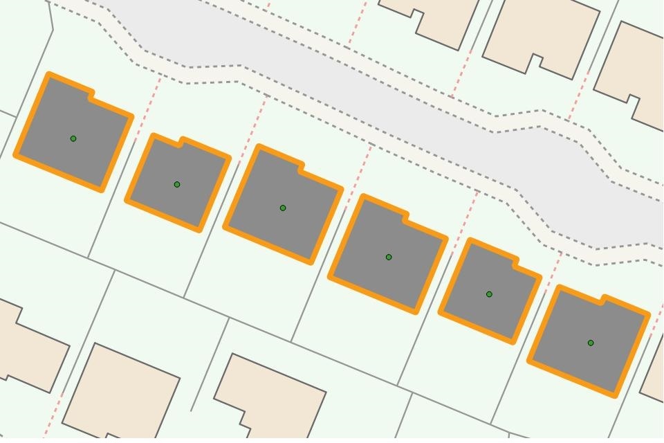
House type: detached
Method of classification: A building with no adjacent addressed building.
Example
House type: semi-detached
Method of classification: A building with 1 adjacent singly addressed building.
Example

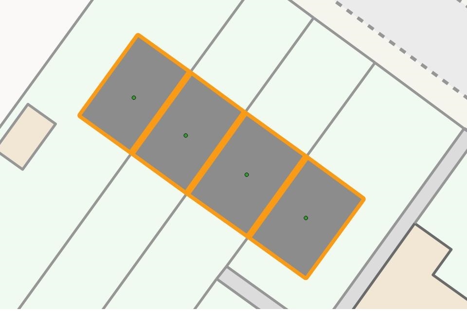
House type: terraced house
Method of classification: A building with one or more singly addressed neighbours.
Example
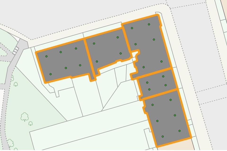
House type: multiple occupancy house
Method of classification: Any building with 2 or more unique addresses in any single building.
Example
[2] Building polygons are building shapes identified on the OS large scale topographic mapping.
The majority of house types can be identified using the above method to an accuracy rate of 96.4% (the accuracy of the algorithm was tested prior to its first implementation).
Sales which cannot be identified using this method (approximately 15 to 30% of the monthly total) are initially categorised as Unassigned. The Unassigned House Types fall into three categories as follows:
- Unknowns: Represents approximately 4% of the monthly total. These are predominately New Build properties without OS address records[1]. The house type will be identified when the property transfer has been fully registered by RoS. Cancelled applications are also included in this category.
- Unaddressed: Represents approximately 1% of the monthly total. These are applications with a RoS Title seedpoint[2] which falls within a building we have identified as ‘unaddressable’ such as garages, sheds and buildings without OS address records. These applications need to be examined manually to determine the accuracy of the sales data and OS address record data.
- None: Represents between 10-25% of the monthly total and is linked to the date of the extraction of the application data. The closer the date of extraction is to the date the application was received by RoS the higher this figure will be. Approximately 80% of the “None” category have not yet passed through the land registration process.
The volumes of Unassigned sales reduce over time as sales applications move through the land registration process, as RoS map data is updated and as updates to mapping products are received from Ordnance Survey.
Ordnance Survey MasterMap® Topography Layer (MasterMap) and AddressBase®Premium (AddressBase)[3] are used to support our land registration activities within RoS. Ordnance Survey are currently the only map provider in in the UK that can deliver the quality and coverage needed for our land registration processes in Scotland. As noted in section 2 above, the provision of this map data is governed by the Public Sector Geospatial Agreement (PGSA). In relation to the RoS administrative data used in our quarterly statistics and in the HPI, these products are used, as noted above, as a tool within our house type methodology. Information about the products provided to RoS is provided below for completeness, therefore, but map data is not included in the RoS administrative data.
OS MasterMap is the definitive source of highly detailed geographic data of Great Britain. Further information about the Topography Layer of this product, what it contains, and how it is created and updated is contained in the Ordnance Survey OS MasterMap Topography Layer support document. The polygons within this Topographic Layer are used to support the identification of house types within the RoS house type methodology.
AddressBase is Ordnance Survey’s addressing product range. It matches Royal Mail Postal Address File (PAF) records to local authority address file records and the AddressBase Premium product provides the most comprehensive and accurate geographic dataset of 40 million addresses, properties and land areas where services are provided. The information for AddressBase comes predominantly from local authorities. There are 32 local authorities in Scotland, with responsibility for functions such as Planning, Building Standards and Street Naming and Numbering, which are the foundations for all address intelligence. The local authority data feeds on a continuous basis into the One Scotland Gazetteer, managed by the Improvement Service, which in turn is shared with the National Land and Property Gazetteer, managed by GeoPlace. The source data is collated, verified and quality assured by GeoPlace. The National Address Gazetteer infrastructure is the single source from which AddressBase products are created and made available by Ordnance Survey. See the Ordnance Survey specification and Product Guide for more information about AddressBase.
Supporting documentation:
- Annex A: Data Collection Process Map: an outline of the land registration process through which our administrative data is collected
- Annex B - Data Extraction and Fields: details of the fields that the Land & Property Data Team extracts from the administrative data for our statistical purposes
- Methodology for House Classification: a full explanation and breakdown of how RoS applies the House Type data from Ordnance Survey to our dataset
- Annex C: Field Classifications and Explanations: a breakdown of the abbreviations and land classifications used in our dataset.
Assessment Rating A2: Enhanced assurance
4.2 Practice area 2: communication with data supply partners
RoS presently has departmental risk registers and business continuity plans in place to safeguard the collection and supply of administrative data. All data at RoS is backed up overnight using both cloud-based and external site servers to ensure the continuity of service. Each department is responsible for their own risk registers and business continuity plans to ensure expertise is utilised if disruptions occur. This provides confidence in the internal data supply that measures are in place to resolve any disruptions to supply quickly and efficiently.
Within RoS, there are a number of teams which encompass registration policy and practice, post-registration enquiries and amendments, and data improvement and quality. These teams liaise with both internal and external stakeholders to correct errors, analyse data, provide feedback and improve registration practice, as well as examining historic data issues and seeking to correct and resolve these.
Internal relationships between the Land & Property Data Team and both the Quality Team and RoS GIS team continue to be robust. Although there are no formal written agreements in place in respect of data quality updates since we are internal departments, we are satisfied that our current communication levels meet our requirements for receiving updates to data quality, process changes and feeding back data amendments (please see Annex D for further details of the data quality assurance process.
With regard to the registration processes, through which RoS administrative data is gathered, there is communication throughout with the agents/solicitors that have submitted the applications to RoS for registration. This communication includes pre-application services (such as the pre-registration reports service – services like this help to improve the quality of applications subsequently received by RoS), application receipts, application rejections (land register applications need to meet certain criteria in order to be accepted for registration and will be rejected if these criteria are not met – the submitting agent will then resolve any issues and resubmit the application), discussion of issues during the registration process, and notification following application completion. On completion of the registration process, the submitting agent will receive a link to the registered title to allow them to conduct a check on the completed registration. Any issues at this stage will be communicated to the RoS rectification team.
Communication with key RoS stakeholders across the range of our products and services is robust and includes the allocation of account managers to key customer sectors, regular newsletters, Law Journal articles, attendance at relevant events and conferences, customer consultations (such as customer surveys, mystery shopping exercises and focus groups), website and social media updates and the establishment of a user experience panel to test the concepts RoS is developing to enhance services.
In relation to external communication around the Ordnance Survey map data[4], the RoS Mapbase Maintenance and GIS teams continue to receive a regular weekly update[5] from Ordnance Survey in regards to the OS MasterMap Topography Layer and six-weekly update with regards to AddressBase Premium. This has been in place since the One Scotland Mapping Agreement (OSMA) data licence was established between Ordnance Survey and Scottish Government to provide this data to all public sector organisations in Scotland and is now covered by the PSGA, although the provision of the weekly update of the OS MasterMap Topography layer predates OSMA. This update supplies change data, such as the addition of new build property footprints and addresses, which supports the land registration process and in turn updates the data that is used as a tool within our house type methodology.
RoS is in regular weekly contact with Ordnance Survey with regard to the map products supplied and the weekly change data. This contact includes flagging up mapping issues to the OS data hub error reporting tool, for example advising them corrections might be required such as when the map doesn’t match associated aerial imagery. Any issues flagged in this way are usually resolved within four weeks and are then included within the regular weekly updates. RoS can also request Ordnance Survey to carry out site surveys through a P24 request. This is a payable service through which RoS can ask Ordnance Survey to provide updated data in specific areas to support the land registration process. The SLA for this service is 15 working days and any updates are again included within the regular weekly feed.
For the administrative data used to create our bulk data services, this communication provides us with regular updates of building and address data that is incorporated into our GIS database every quarter. This data is then used as a basis to create and update the house type field within our statistical reports using our House Type Methodology (listed as Item 3 in section 4.1 above). The map data provided by Ordnance Survey is only used as an input, therefore, to support the classification of sales within a certain house type. The map data already provided and revised via the update meets our statistical needs and so in relation to house types there is minimal need for additional communication with Ordnance Survey beyond the provision of the regular updates.
In certain instances where it has not been possible to identify a house type this can be due to our own internal processes, such as where the property has not yet been mapped on our Digital Mapping System or the seed point has not been placed within the curtilage of the property, rather than data not being available from OS MasterMap or AddressBase. Further details relating to unassigned house types and how these are dealt with are provided in section 4.3 below.
Periodical examinations are performed on the quality of the classifications provided via the Ordnance Survey data. These are used in conjunction with the full statistical analysis of this data. The full analysis was conducted when the House Type Methodology was created. Quality levels were deemed to be suitable for our needs by external scrutiny[6].
In relation to the provision of the administrative data for the UK HPI, a monthly data delivery is provided to ONS to allow them to apply the HPI methodology to the data. This data delivery contains the most recent month of available data as well as update data for the previous 12 months. This data is delivered via a secure server (RoS Data Portal). There is regular communication among the members of the HPI working group (ONS, RoS, HM Land Registry and Land & Property Services Northern Ireland) and catch up meetings are held when needed.
Assessment Rating A2: Enhanced assurance
4.3 Practice area 3: QA principles, standards and checks applied by data suppliers
Since RoS is the primary data supplier, we present our full QA procedure and checks under the practice area 4 section in paragraph 4.4 below.
Our service standards and strategic objectives can be found in our annual corporate plan. One of RoS’ strategic objectives is to ‘Deliver more benefits to Scotland by providing innovative and accessible land and property data’. Under this objective there is commitment to continuously improve the quality of our data, indicating that the quality of the data held within our registers is one of RoS’ core priorities. Our performance against our service standards and targets, including the percentage of registrations requiring corrective action over a 12 month period, is audited within our annual reports[7], and is regularly updated on our website. RoS has also received the customer service excellence award. This is the national standard for excellence in customer service. It drives improvement and recognises high quality public service.
The Quality Team conducts internal quality audits, spot-checking applications on a regular weekly basis. They carry out both Legal and Plans checks on the applications registered, taking a random selection of casework and following data point checks on the data fields to ensure they accurately reflect the deed and application form submitted. The majority of quality checks completed are done pre-dispatch, with inconsistences returned to the plans or legal settler who processed the original casework to allow them to rectify the error.
Data queries from our online service, ScotLIS, are also handled by relevant teams within RoS. These queries come from the various stakeholders who use this RoS service. Queries and other feedback on the data held within ScotLIS are sent in on a daily basis and investigated on a case by case basis with the outcome communicated back to stakeholders. Feedback reports are produced and made available to all Intake team leaders and managers in order to highlight training and development issues.
The post-registration enquiries and amendments team are responsible for completing applications to rectify inaccuracies on registered titles. The Land & Property Data Team receives a regular report of all rectifications completed by this team and will incorporate any relevant changes into the administrative data used to create our statistics.
The OS MasterMap and AddressBase products that update the mapping data that is used as an input within the RoS house type methodology are subject to Ordnance Survey QA procedures. The specifications and product guides for these products are available on the Ordnance Survey website and links to these specifications have been provided in section 4.1 above.
OS apply relevant Standards to their processes, products and services. With particular regards to data quality, they apply the principles and methodologies of:
- ISO19157: Geographic Information – Data quality (2013). ISO - ISO 19157:2013 - Geographic information — Data quality
- ISO19158: Geographic information - Quality assurance of data supply (2012). ISO - ISO/TS 19158:2012 - Geographic information — Quality assurance of data supply
- ISO2859: Sampling procedures for inspection by attributes (series). Link to part 1 (1999) provided here ISO - ISO 2859-1:1999 - Sampling procedures for inspection by attributes — Part 1: Sampling schemes indexed by acceptance quality limit (AQL) for lot-by-lot inspection
- ISO 19011: Guidelines for auditing management systems (2018). ISO - ISO 19011:2018 - Guidelines for auditing management systems’
AddressBase is produced in accordance with the National Land and Property Gazetteer Data Entry Conventions and Best Practice for Addresses and they are in compliance with the national standard for the representation of address information – BS7666 Parts 1 and 2.
For the RoS house type methodology, the only limitations of the map data used are in relation to land that hasn’t yet been mapped or updated by Ordnance Survey, such as new build developments or redevelopments of properties, and in relation to our own mapping processes, such as the RoS methodology cannot be applied when our own map data has not been created or updated correctly. As previously noted, however, the Ordnance Survey data is the most comprehensive and accurate data available for Scotland and regular updates are provided under the PSGA.
As noted under practice area 2 in section 4.2 above, periodical examinations are performed on the quality of the classifications provided via the Ordnance Survey data. These are used in conjunction with the full statistical analysis of this data. The full analysis was conducted when the House Type Methodology was created and the data deemed to meet our needs.
Assessment Rating A2: Enhanced assurance
4.4 Practice area 4: Producers QA Investigations and documentation
RoS presents a complete description of our internal quality assurance procedure and checks completed on the data. The Quality Assurance Process document in Annex D details the full step-by-step procedure followed by the Land & Property Data Team to fully quality assure the data extracted from the Land Register on a weekly basis. The main checks undertaken as part of this process are:
- Price paid checks – to ensure that price paid details are accurate, particularly for high and low value properties
- Date of entry checks – to ensure that the date of entry, when the purchaser took possession of the property, is accurate (this is particularly important for HPI data which is extracted based on date of entry)
- No duplicate applications or sales included – to ensure that any duplicate application numbers (usually created for internal administrative reasons) are removed so that a single sale is not counted more than once
- Only true market residential sales included – to remove sales between family members or sales of a share of a property that might not reflect the true market value and could therefore have an impact on house price statistics
The main strengths and weaknesses of Registers of Scotland’s (RoS) residential sales dataset, which is used in the creation of the House Price Index and the RoS House Price statistics, are highlighted in Annex E. Overall, the quality of data extracted from the Land register is good, but is further enhanced and improved by the quality assurance that is undertaken by the Land & Property Data Team.
The Quality Assurance Process document shows that there is a uniform approach to quality assurance to provide consistency in the standard of data being produced. Regular monthly quality assurance meetings are held within the Land & Property Data Team to garner feedback on processes, debate improvement features, and develop new procedures to add to or update the quality assurance checks.
The House type methodology and guidance notes links are distributed and attached to every statistical release. They contain full details on how the data is collated and reported, showing the criteria RoS have used in compiling the quarterly statistical releases, and monthly and quarterly time series documents.
Internally, periodical examinations are performed on the quality of the classifications provided via the RoS house type methodology, in conjunction with the full statistical analysis of this data previously undertaken in the Methodology for House Classification, but our needs in terms of the map data are met and we are satisfied with the Ordnance Survey standards in this regard. The PSGA sets out the provision of product updates, which is all that is needed for the house type methodology to work effectively. There is clear agreement, therefore, about what data is provided, when and how it will be updated and the quality of the data meets our statistical needs. The Ordnance Survey data is used as an input within our house type methodology and is used to support the classification of sales within a specific house type. It is often this methodology and our internal processes rather than the map data itself that can cause inaccuracies or omissions, but again these are mitigated through quality checks, data updates and the RoS Land & Property Data Team undertaking quality assurance on the data. The Ordnance Survey data itself is subject to quality standards and procedures. Links to the relevant specifications, quality documents and user guides are provided in sections 4.1 and 4.3, so will not be repeated here.
If we are unable to classify the house type using the house type methodology – there are a number of reasons for this that are highlighted in the methodology document and in section 4.1 above, including internal reasons, such as where the property has not yet been mapped on our Digital Mapping System or the seed point has not been placed within the curtilage of the property – then these properties are noted as unassigned and updated once the classification becomes available. These unassigned properties only make up a small proportion of the overall monthly sales volumes, and there are a sufficient classified figures for the methodology to work effectively. RoS conducts internal exercises to reduce the volume of unassigned properties, for example seed point checks to ensure that the RoS mapping point is located in the correct position within the curtilage of the property to allow the house type to be defined properly.
Supporting documentation:
- Annex D – Quality Assurance Process: a guide on how the Land & Property Data Team process weekly Land Register extracts.
- Annex E - Identified list of Dataset Strengths and Weaknesses
Assessment Rating A2: Enhanced assurance
5. User engagement
RoS has dedicated communications and stakeholder engagement teams that are responsible for managing RoS’ relationship with all of our customers, and for eliciting customer feedback and gauging customer satisfaction. These teams also manage user events and the circulation of RoS statistics via the RoS website, via media contacts and via social media (Twitter and Facebook). They also manage the RoS Data Stats Alert Service, which allows customers to subscribe to receive updates when the following statistics are updated: the monthly house price index, the quarterly house price statistics, the 10 year property market report, the monthly house price statistics and the calendar year report.
As part of the HPI development, two key user events were held in Scotland, the first to promote the online user consultation and to actively engage with users and gather their comments and queries, and the second to provide feedback on the results of that consultation and to gather further comments and queries. These events involved the keys users of our existing house price statistics and included the following key sectors:
- Scottish Government (statisticians, policy developers)
- Local authorities
- Assessors
- Estate agents
- Other producers of house price data or property services
- Media
Following the first publication of the HPI in June 2016, a survey was conducted in September 2016 to aid evaluation of the publication and to feed into future development. A summary of responses has been published in relation to this survey.
RoS has a good relationship with our key users, and engagement with them is ongoing. Following the HPI user events it was clear that users wanted RoS to continue with our existing quarterly statistics as well as the HPI for Scotland. While RoS no longer publishes a quarterly report and statistical release for these statistics, we still make them available in an accessible format on our website and have engaged with users around the withdrawal of the report and release.
RoS also engages with the wider statistical community in Scotland via appropriate forums, for example ScotStat, and attendance at relevant events, for example the annual Scottish Official Statistics Conference.
[1] An “address record” contains point coordinates which are used to locate an address spatially and on the OS mapping.
[2] A “Title seedpoint” is a point marker used to identify the position of a Land Register Title on the OS mapping.
[3] Click on the links to find out more about MasterMap and AddressBase products.
[4] While Ordnance Survey (OS) map data is used as the base layer for RoS land registration mapping activities, for the purposes of this QAAD, the communication referred to only relates to the provision of the map data for the house type methodology. There is much wider communication relating to the overall RoS land registration requirements, in addition to the updates referred to, including regular meetings and liaison with OS representatives. RoS also has representation on the Scottish Geospatial Management Board, which represents Scottish Government in relation to the PSGA.
[5] Under the PSGA, the OS MasterMap Topography Layer has a 6-weekly update as standard, but RoS has agreed a more frequent update with Ordnance Survey.
[6] “Methodology for House Classification”, Alastair Reid, December 2007. The methodology was written as part of an MSc submission and assessed internally within RoS, and externally by Scottish Government statisticians and professors at City University of London.
[7] https://www.ros.gov.uk/__data/assets/pdf_file/0018/221157/RoS-ARA-21-2022.pdf. In 2021-22, the target was to complete an average of 93% of applicable registration cases with no quality fails or errors. 94.8% of applications met this target.