Natural Flood Management Programme: evaluation report
Published 8 December 2022
Applies to England

© Crown copyright 2022
This publication is licensed under the terms of the Open Government Licence v3.0 except where otherwise stated. To view this licence, visit nationalarchives.gov.uk/doc/open-government-licence/version/3 or write to the Information Policy Team, The National Archives, Kew, London TW9 4DU, or email: psi@nationalarchives.gov.uk.
Where we have identified any third party copyright information you will need to obtain permission from the copyright holders concerned.
This publication is available at https://www.gov.uk/government/publications/natural-flood-management-programme-evaluation-report/natural-flood-management-programme-evaluation-report
Executive summary
Natural Flood Management (NFM) can manage flood and coastal erosion risk by protecting, restoring and emulating the natural processes of:
- catchments
- rivers
- floodplains
- coasts
It includes:
- re-meandering of rivers
- restoration of wetlands
- targeted woodland planting
Between 2017 and 2021, we invested £15 million of government funding in the NFM programme. The programme was made up of 60 pilots across England:
- 26 were catchment scale pilots led by risk management authorities
- 34 were community scale pilots led by local groups and charities
The objectives of the programme were to:
- reduce flood and/or coastal erosion risk
- improve habitats and biodiversity
- contribute to research
- promote partnership working
We have completed a qualitative process evaluation of the NFM programme. This examined the activities involved in the implementation of NFM interventions and the project management processes and approaches adopted by the NFM pilots.
The evaluation was based on survey responses from managers of the pilots and others contributing to the programme. This report sets out the learning from the process evaluation and is structured around the 4 phases of the project lifecycle:
- partnership working
- valuing benefits and project assessment
- project implementation
- monitoring and sustaining the benefits
Partnership working
NFM is dependent on working with local partners and the local community. The NFM programme attracted more than 85 partners to support the completion of the pilots. Aside from the Environment Agency, organisations involved included:
- rivers trusts
- wildlife trusts
- local authorities
- Natural England
- Forestry Commission
- landowners
- universities
- local businesses
The NFM Programme has highlighted the value of forging strong community-based partnerships, supported by effective local leadership. Local experience and knowledge were also key to the successful delivery of the pilots, particularly of landowners and farmers.
The NFM community pilots identified the need for the investment of both time and funding in engagement. Effective, ongoing engagement helps gain the trust of landowners, and sustains the partnerships needed for NFM. The NFM programme found that it took, on average, between 12 and 18 months to reach agreement and the consent of landowners.
The NFM Programme also identified the importance of being clear on responsibilities for maintaining NFM measures over the longer term. Responsibilities for flood management structures or natural features generally lie with landowners. The programme found that there was a lack of understanding about landowner maintenance responsibilities once NFM measures were installed.
Valuing the benefits and project assessment
The NFM pilots were subject to different funding rules from standard flood and coastal erosion risk management (FCERM) projects. They also benefitted from being judged on different outcomes during appraisal.
Generally, FCERM projects need to demonstrate reduction in risk. This is measured in terms of properties better protected, which determines the amount of FCERM government funding they can claim. This cannot be easily or accurately predicted for an NFM intervention. NFM is designed to slow the flow or store floodwaters, but the effect can vary depending on catchment conditions. This is very different to traditional engineered defences that tend to have more predictable performance. In many cases, NFM is best deployed in combination and alongside an engineered, hard flood defence.
The NFM pilot catchment projects found it difficult to tell if commissioning detailed modelling would help give them certainty of the likely flood risk reduction. This is because NFM benefits accumulate over a long period of time. The community NFM pilots decided that in many cases modelling was not suitable in practice for smaller scale, less complex projects. The NFM Programme found that the detailed evidence needed to justify the FCERM funding for a project is often disproportionate to the size and cost of the project.
The NFM pilots have shown that the combination of different NFM interventions across a large catchment area can:
- reduce runoff
- store significant volumes of water
However, the programme found it difficult to package individual NFM projects across a larger catchment geography.
Developing a lighter touch approach to assurance was identified as a helpful way of streamlining processes for future NFM projects.
Project implementation
Environmental Non-Governmental Organisations (eNGOs), such as rivers trusts, wildlife trusts and members of catchment partnerships led the delivery of many of the NFM pilots. These organisations have no statutory duties as risk management authorities (RMAs) for flood and coastal risk management. However, eNGOs participating in catchment partnerships have a good understanding of environmental improvement (habitats, biodiversity). They are also often best placed to access funds from different sources to achieve multiples NFM benefits.
Through the NFM Programme, it has become clear that current approaches to grant administration can create hurdles to allocating funding to smaller or community-based organisations. RMAs can use the FCERM Grant Memorandum to award funding, whereas third sector and community groups could not be paid under this route. Instead, they were paid through Partnership Grants under the Charities Act. The payment of FCERM government funding via this route was tested for the first time on the NFM programme. This required a delegation of function from Defra.
Partnership Grants had mixed feedback. Many of the eNGOs leading the NFM community pilots were part of the ‘Catchment Based Approach’ (CaBA) and could access support. However, smaller local community groups (with no or limited experience in managing public grants) found it very challenging. Some had to partner with an established charity who managed the funding for the pilot.
To undertake works in the landscape, the NFM pilots had to obtain multiple permits, consents, and licences which caused delays to project delivery. The programme demonstrated the benefits of managing environmental permits and legal agreements efficiently. This included the Environment Agency’s use of catchment permits to consent to works for groups of interventions. In addition, the Environment Agency issued guidance to minimise the risk of the pilots having a detrimental impact on the environment. The Environment Agency facilitated the sharing of legal agreements and other documents amongst the pilots.
Monitoring and sustaining the benefits
The Environment Agency’s ‘Working with Natural Processes Evidence Directory’ (WwNP), shows that NFM can:
- reduce flood risk
- contribute to nature recovery and climate resilience
The pilots in the NFM Programme collected measurable data on the contribution NFM makes towards flood resilience objectives. This information will be used to update the WwNP Evidence Directory in 2023. The updated directory will help guide practitioners on technical choices and quantifying NFM benefits.
Working with CaBA, the Environment Agency developed an online tool to coordinate the monitoring and evaluation of the NFM pilots. This shows that the pilots have installed over 4,500 NFM measures across England. Some of the pilots are continuing to install NFM measures with funding from other sources. Most pilots will collect data for many years to come.
The NFM Programme has shown that work to increase flood resilience can also deliver wider benefits to local nature recovery. Collectively the pilots slowed and stored water upstream of 15,000 homes in areas at risk of flooding, equivalent to 1.6 million cubic metres. The wider benefits included:
- 610 kilometres of river created or improved
- 4,000 hectares of habitat created or improved
- 100 hectares of woodland planted
Significant progress has been made in organising NFM data through the NFM programme. However, more work is required to implement nationally consistent ways of recording data and information from NFM projects across England.
The NFM Programme has highlighted the importance of sustaining NFM features over time through good environmental land stewardship and land management. The government’s Catchment Sensitive Farming (CSF) scheme provides a helpful mechanism for achieving this. The CSF scheme signposts farmers and landowners to financial support for managing land in a way that mitigates risks from floods and drought. It also enables biodiversity, carbon sequestration, water quality and other benefits. The scope of the CSF scheme has recently expanded to include NFM, although NFM advice is not yet available in all areas.
The future Environmental Land Management (ELM) schemes have the potential to maximise integrated outcomes for water, nature, flood and drought resilience. The schemes will also contribute to the reduction of and adaptation to climate change. These schemes could provide an important mechanism for sustaining NFM measures over the longer term.
The new Local Nature Recovery Strategies are an opportunity to identify where actions for nature could benefit flood and coastal risk management. They will also help bring resources together to promote and sustain the benefits of NFM measures.
Next steps
The National Flood and Coastal Erosion Risk Management Strategy for England requires RMAs to work with catchment partnerships, coastal groups, land managers and communities to mainstream the use of nature-based solutions. The government’s Flood and Coastal Erosion Risk Management: Policy Statement also commits to doubling the number of government funded projects. This includes nature-based solutions to reduce flood and coastal erosion risk.
The Environment Agency are already working with partners to mainstream NFM approaches as one of the tools to reduce flood and coastal risk. The FCERM Strategy Roadmap commits to addressing many of the lessons learnt from the NFM programme. This includes working with partners, including CaBA, Blueprint for Water and Natural England. This work will develop options for better recording data and information from NFM projects. It also includes developing new tools and training for practitioners, policy makers and community groups to help build NFM skills and capabilities.
This evaluation report will support the continued efforts by the Environment Agency and partners to mainstream NFM. It will be backed up by the rich variety of case studies, tools and tips for practitioners provided by the NFM programme. Collectively these efforts will maximise the use of nature-based solutions to drive greater flood and coastal resilience.
What is Natural Flood Management
Natural Flood Management (NFM) helps manage flood and coastal erosion risk. It does this by protecting, restoring and emulating the natural processes of catchments, rivers, floodplains and coasts. Investing in NFM can also provide wider benefits. These include improving habitats and biodiversity, increasing water quality and availability of drinking water, and improving health and wellbeing.
Natural Flood Management techniques
- In stream structures for example woody debris
- Blocking of moorland drainage channels
- Woodland planting
- Land and soil management practices, cover crops, hedgerows, suitable crops
- River morphology and floodplain restoration for example removal of embankments and remeandering
- Inland storage ponds and wetlands
- Protecting riverbanks for example stock fencing
- Sustainable urban drainage systems for example swales, wetlands in urban areas, green roofs, permeable pavements, detention ponds, filter strips
- Saltmarsh restoration
- Coastal managed realignment
- Coastal change management
Reducing flood risk through nature-based solutions is not new to flood and coastal risk management practitioners. For years, we have managed many of our beaches to take the energy out of stormy seas to protect our coasts. Many places around the country have also reconnected rivers with their natural floodplain to make space for water away from vulnerable built-up areas.
What has changed is our understanding of how to work with other stakeholders to implement the most effective blend of NFM measures in the right locations. Too often, people talk about making a choice between hard (conventional) defences or nature-based solutions – as if there were conflict or competition between them. The NFM programme has helped us understand the role that NFM can play in complementing conventional flood or sea defences to enhance flood and coastal resilience.
We are currently implementing the Flood and Coastal Investment Plan for 2021 to 2027. In March 2020, the government announced a £5.2bn programme to better protect hundreds of thousands of properties from flooding and coastal erosion.
In delivering the investment plan we must continue to do what we have been doing. This is building and maintaining strong defences to reduce the risk of places being flooded. But managing future climate risks by building bigger defences will not always be the right approach. We need to use all the tools available, including NFM. This is particularly the case as a changing climate causes more frequent, intense flooding and sea level rise.
Parliament adopted the Environment Agency’s National Flood and Coastal Erosion Risk Management (FCERM) Strategy for England in September 2020. The FCERM Strategy calls for the nation to embrace a broad range of resilience actions, including better protection from flooding and coastal change. In the face of a changing climate, we also need to make our places more resilient to flooding and coastal change. Being more resilient means that when flooding happens it will:
- cause much less harm to people
- result in less damage
- allow life to get back to normal much more quickly
The FCERM Strategy helps to implement the government’s Flood and Coastal Erosion Risk Management: Policy Statement. The goal of the policy statement is to better protect and prepare the country for flooding and coastal erosion. This includes harnessing the power of nature to reduce flood and coastal erosion risk and achieve wider benefits. The policy statement commits to doubling the number of government funded projects which include nature-based solutions in the current £5.2bn investment programme (a total of 260 projects).
We have recently worked with partners to develop the FCERM Strategy Roadmap that contains practical actions up to 2026. By completing these, including actions relating to NFM, we will stay on track to implement the strategy’s 2100 vision.
NFM Programme overview
Between 2017 and 2021, we invested £15 million of government funding to benefit people and learn more about NFM through 60 pilots across England. Of these:
- 26 were catchment scale pilots led by risk management authorities
- 34 were community scale pilots led by local groups and charities
The primary aims of the NFM pilots were to:
- reduce flood or coastal erosion risk to homes
- improve habitats and increase biodiversity
- contribute to research and development
- support and develop partnership working with and between communities
Figure 1: location of the Catchment and Community pilots
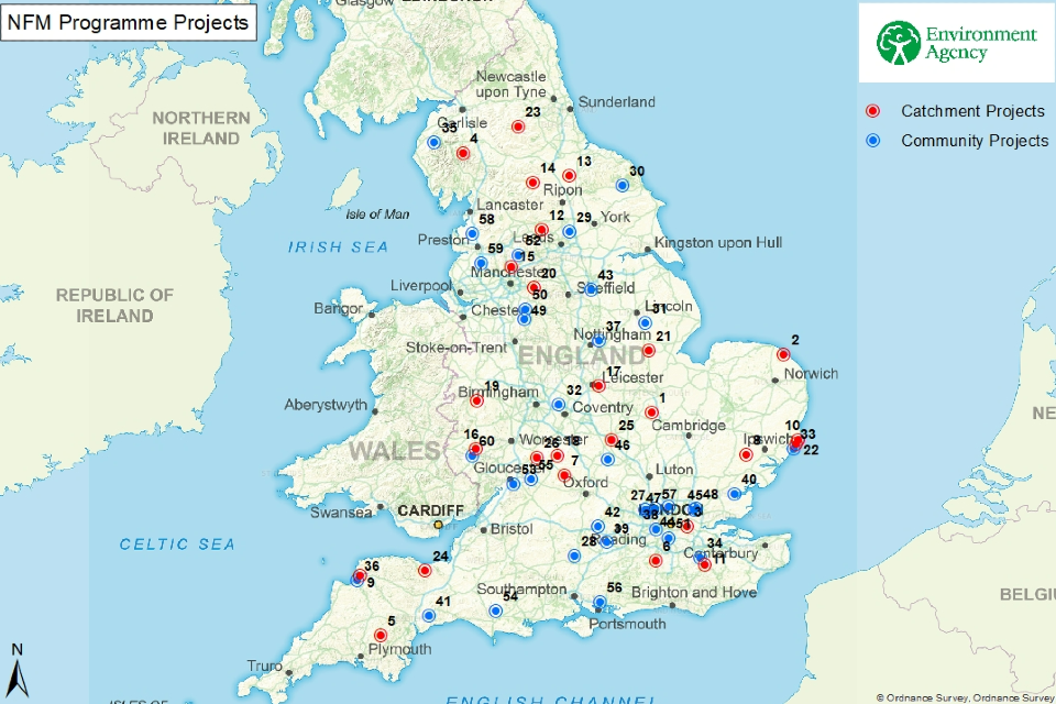
Catchment Projects:
- Alconbury Brook
- Bacton Sand Engine
- Clothworkers Wood
- Cumbria Floods Partnership Action Plans
- Dartmoor Headwaters
- Dorking Flood Alleviation Scheme (FAS)
- Evenlode
- Interventions across East Suffolk & Norfolk
- Marine Pioneer - North Devon - Taw Torridge
- Marine Pioneer - Suffolk - Slaughden
- Medway
- North Yorkshire - Backstone Beck
- North Yorkshire - Brompton
- North Yorkshire - Upper Ure / Bishopdale
- Radcliffe & Redvales
- River Lugg & Wye
- Rover Soar Tributaries Tributaries
- Shipston
- Shropshire Slow the Flow - Severn Tributaries
- Slow the Flow Greater Manchester, Merseyside & Cheshire (GMMC)
- Swaton Flood Resilience Scheme
- Tidal Flood Management and Saltmarsh - Suffolk
- Weardale NFM Demonstrator
- Williton, Monksilver and Doniford Flood Alleviation Scheme (FAS)
- Wooton Brook
- Worcestershire Avon/Cotswold Escarpment Tributaries
Community Projects:
- Bishop’s Wood
- Bourne Rivulet Restoration & Flood Management
- Collingham Beck
- Derwent Villages
- Dunston Floodplain Reconnection
- Fillongley & River Bourne
- Havergate & Orford
- Hawden Stream
- High Rogerscale Floodplain Reconnection
- Kenwith Valley
- Lowdham
- Lower River Crane Restoration
- Management of A33 Surface Water Run-off
- Northey Island Saltmarsh Regeneration
- Ottery St. Mary
- Pang Valley
- Papermill Dyke
- Pymmes Brook Deculverting
- Rise Park Stream
- River Leck Catchment
- River Pinn Park Woods
- Salmons Brook
- Slowing the Flow - Upper Dane
- Slowing the Flow - Upper Dean Catchment
- SuDS in Sutton’s Schools
- Midgelden Brook
- Twyver Catchment
- Upper Piddle Headwaters
- Upper Thames Catchment
- Wallington Catchment Management Scheme
- Woodland & River Management in Two Headwater Streams
- Wyre
- Yarrow Meadows
- Yazor Brook Flood Alleviation
Key programme milestones and activities
April to November 2016
Government allocate £15m of FCERM GiA funding to pilot NFM interventions in England.
March to May 2017
Open competition launched, with Catchment Partnerships and EA Area teams working with communities to develop proposals.
July 2017
Announcement of allocation of the funding to projects in the NFM Programme.
August 2017
Catchment Programme projects develop business cases and prepare to begin works.
Community Programme projects develop business cases and complete grant paperwork before work can begin.
November 2017
A community page within the Knowledge Hub site created for the sharing of ideas and experiences within the both the Catchment and Community Scale NFM projects.
May 2018
Monitoring and Evaluating Natural Flood Management AGOL tool created to coordinate monitoring and evaluation of NFM projects.
January 2019
Natural Flood Management Programme: Interim Lessons Learnt report (CaBA). The report shared lessons from the early stages on the NFM programme.
August 2019
Reporting, monitoring and evaluation the Defra funded Natural Flood Management projects (CaBA) published.
August to September 2020
Online survey of all NFM Project Managers, to understand key issues during project delivery.
November 2021
Natural Flood Management Programme: initial findings - report sharing initial lessons from and explaining the benefits and successes of the NFM programme.
December 2022
Natural Flood Management Programme: evaluation report - evaluating the process of the NFM programme delivery and lessons learnt.
2023
Working with Natural Processes Evidence Directory update, providing quantitative benefits of NFM measures.
In 2018, working with the Catchment Based Approach (CaBA), we developed an ArcGIS online (AGOL) tool to coordinate the monitoring and evaluation of the pilots. This tool shows that the pilots have installed over 4,500 NFM measures across England. Collectively, they have slowed and stored water upstream of 15,000 homes in areas at risk of flooding, equivalent to 1.6 million cubic metres. The wider benefits delivered include:
- 610 kilometres of river created or improved
- 4,000 hectares of habitat created or improved
- 100 hectares of woodland planted
Achievements from the NFM Programme
The main achievements from the Natural Flood Management Programme between 2017 and 2021 are:
- slowing and storing water upstream of 15,000 homes in areas at risk of flooding (the equivalent of 1.6 million cubic metres)
- attracting £6 million of funding contributions
- involving 85 partners - including government agencies, charities, local community groups and environment non-government organisations
- improving 610 kilometres of river
- improving 4,000 hectares of habitat
- planting 100 hectares of woodland
The figures have been derived using data (summer 2021) from:
- NFM Projects monitoring and evaluation tool on project outputs
- estimated benefits of NFM interventions used in the pilots
The pilots and associated research have taught us a lot about how to use NFM effectively, and its contribution to enhancing flood and coastal resilience. The Working with Natural Processes (WwNP) Evidence Directory published in 2017 sets out the evidence for NFM from that time. The pilots in the NFM programme have collected further measurable data on the contribution NFM makes towards flood resilience objectives. This information will be used to update the WwNP Directory in 2023. The updated directory will help guide practitioners on technical choices and quantifying NFM benefits.
In implementing the NFM Programme our partners have brought expertise, contributed funding, and provided thousands of hours of voluntary time in delivering the NFM pilots. Many pilots will continue to collect data for many years to come.
Evaluation method
Evaluation scope
This evaluation of the NFM Programme is a process evaluation. Process evaluation focuses on what can be learnt by how a policy or programme was implemented, what worked well and less well. For more information, see: HM Treasury Magenta Book.
Process evaluation examines the activities involved in the implementation of NFM interventions and the project management processes and approaches adopted by the NFM pilots. It considers what worked well and why, and what could be improved. The evaluation report is structured around the 4 phases of the project lifecycle, and draws out the key learning from each phase:
- partnership working
- valuing benefits and project assessment
- project implementation
- monitoring and sustaining the benefits
In addition to this process evaluation, we are capturing the changes caused by the NFM interventions including their measurable contribution towards flood resilience objectives. Pilots monitored outcomes using the NFM Projects Monitoring and Evaluation Tool (AGOL) and guidance: Reporting, monitoring and evaluating the Defra funded NFM projects. This information will be used to update the WwNP Evidence Directory in 2023.
Evaluation methodology
This evaluation draws on survey data captured in 2 discrete evaluation phases.
Phase 1 was an online survey held in the first 2 weeks of September 2018. The survey provided information relating to the 4 phases of the project lifecycle. The audience was the 60 NFM pilot managers plus a wide supporting network. 122 responses were received.
An interim report was published in January 2019 drawing on this evidence: Natural Flood Management Programme: Interim Lessons Learnt.
Phase 2 was a further online survey held August to September 2020. The audience was the NFM pilot managers. 40 responses were received. The survey identified several considerations from pilot managers relating to:
- permits, permissions, consents etc
- monitoring
- legal advice/agreements
- maintenance agreements and regimes
- engagement
The findings from Phase 2 contributed to the publication: Natural Flood Management Programme: initial findings.
Limitations to the evaluation
- Objectivity: the evaluation may have benefited from greater independence. Surveys were completed by pilot managers and those contributing to the NFM programme. Independent interviews may have drawn out a broader perspective.
- Methods: Phase 1 and Phase 2 surveys were largely quantitative in their design. While these provided a breadth of information and made analysis relatively simple, alternative or additional methods may have provided richer information.
- Evaluation scoping, design, and conduct: not all projects responded to the surveys, or answered all the questions. Some projects submitted responses from multiple practitioners, therefore the surveys may not have fully captured an accurate representation of all experiences and views.
- Measuring impact: the scope of the evaluation did not include a full evaluation of the impact of the programme. This would have required a different evaluation approach set up to gather data on the full range of impacts of the pilots and comparing these to a counterfactual.
Partnership working
The key stakeholder groups for NFM projects are:
- government (local and national)
- landowners/farmers
- local communities (including eNGOs and charities)
Alongside these stakeholders, project contractors were also fundamental to the delivery of the NFM project pilots. The contractors were often responsible for the work on the ground and any associated modelling work.
The NFM Programme worked with more than 85 partners, generating partner contributions of £6 million. These partners were all legal entities, such as eNGOs, charities and community groups. There were also many other individuals who volunteered their time and skills to the projects.
Table 1: percentage breakdown of partners supporting pilots in the NFM programme
| Partners | Percentage % |
|---|---|
| Landowner or representative | 6 |
| Defra | 3 |
| Environment Agency | 21 |
| Forestry Commission | 5 |
| Natural England | 11 |
| Local Authority / IDB | 23 |
| Local Company | 3 |
| Local organisation | 27 |
| University | 3 |
Governance
Different governance arrangements were adopted across the NFM Programme, drawing on teams with a variety of knowledge and experience. Most catchment scale pilots were led by Environment Agency staff, who had experience using established governance, processes and frameworks to ensure effective implementation. Pilots were in many cases led by the Environment Agency’s Partnership and Strategic Overview (PSO) teams, or by Catchment Coordinators. These teams already had established links with partner organisations within the catchments. These partners included rivers trusts, wildlife trusts, charities, and catchment partnerships.
FCERM grant-in-aid (GiA) funded projects can be delivered by any Risk Management Authority (RMA). For criteria around FCERM GiA funding see Grant-in-Aid Forms: Flood Risk Management Authorities.
However, local authorities were the only RMA other than the Environment Agency to lead projects in the NFM programme. These local authorities used their own resources and had access to their own contractors and suppliers, as well as to the Environment Agency’s framework contractors. Some local authorities used the funding to establish dedicated NFM pilot manager roles. This proved successful because these roles had the capacity to identify opportunities in the community to deliver NFM measures.
In one of the catchment scale pilots, the local authority acted as an intermediary with the Shipston Area Flood Action Group (SAFAG). The local authority already had an arrangement with the group, which was formed in 2014 before the NFM programme. The group won the Environment Agency Flood and Coast Excellence 2021 Award for Community Partners.
Case study: Shipston Area Flood Action Group (SAFAG) - the power of partnerships
Shipston Area Flood Action Group (SAFAG) is a community led volunteer team. Their vision is to reduce flooding to homes and businesses using NFM measures across the River Stour in Warwickshire.
The group formed in 2014 and has members from 6 communities. They started to put NFM measures in place in 2017. They now have over 700 leaky barriers, and ponds to slow the flow of water during heavy rainfall. This has reduced the flood risk to 17 villages and towns.
The project has cost £312,000 of which £275,000 has come from the NFM programme, and £37,000 from partners. This does not include the time, materials and land donated to the project.
The group won the Environment Agency Flood and Coast Excellence 2021 Award for Community Partnership. The SAFAG Chairman Phil Wragg said:
“This award gives SAFAG recognition at national level. It is the culmination of 5 years work by a fantastic volunteer group. It wouldn’t have happened without the willing support of over 40 farmers and landowners to whom we give huge thanks. Thanks also to the Environment Agency for their unstinting support and also to relevant Parish, Town, District and County Councils and many others who have played a part.”
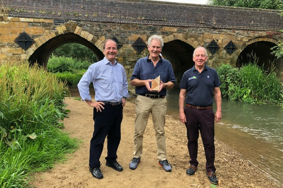
Photograph of 3 SAFAG members holding EA Award on a Shipston river bank. From left to right volunteers are Mike McCarthy, Phil Wragg and Geoff Smith.
For the NFM community pilots, a range of governance arrangements were tested. In every case, there was an Environment Agency appointed contact, and all pilots were supported by the Environment Agency or a local authority.
The NFM Programme demonstrated that the scale of funding, the location, and the organisations involved can all influence the best governance arrangement for a specific project. It also highlighted the importance of having an effective leader and a vision for the project. The leader is required to bring partners and local stakeholders together to broker agreement within the project. This includes agreeing the location, design and size of flood risk measures adopted with the manager of the land on which they are proposed.
Stakeholder engagement
In a Phase 2 survey the NFM pilot managers identified the stakeholders they engaged with. The most common groups were:
- community groups and local authorities (96% of responses)
- local organisations such as rivers trusts, wildlife trusts (85% of responses)
- research institutions and universities (75% of responses)
- schools (over 50% of responses)
- businesses (over 30%)
In general, respondents reported good levels of success in engaging with different stakeholders.
Table 2: NFM pilot manager success levels in engaging different stakeholders
Notes for table:
- there were 55 responses
- local organisations are Rivers Trusts, Wildlife Trusts and so on
| Stakeholder | Very successful | Somewhat successful | Neither successful nor unsuccessful | Somewhat unsuccessful | Very unsuccessful | Not applicable / not engaged |
|---|---|---|---|---|---|---|
| Internal drainage board | 3.60% | 14.50% | 7.30% | 0.00% | 0.00% | 74.50% |
| Business (excluding landowners) | 5.50% | 14.50% | 12.70% | 3.60% | 0.00% | 63.60% |
| Schools | 14.50% | 12.70% | 10.90% | 5.50% | 1.80% | 54.50% |
| Research institutions / universities | 23.60% | 25.50% | 12.70% | 9.10% | 3.60% | 25.50% |
| Local organisations | 47.30% | 25.50% | 7.30% | 0.00% | 5.50% | 14.50% |
| Community groups | 43.60% | 40.00% | 9.10% | 1.80% | 1.80% | 3.60% |
| Local authority | 52.70% | 29.10% | 7.30% | 5.50% | 1.80% | 3.60% |
Pilots were also asked questions about the common challenges faced when engaging with stakeholders, and how straightforward (or not) these were to overcome.
Table 3: ability of NFM pilots to overcome stakeholder concerns
| Challenges to overcome | Very easy to overcome | Moderately easy to overcome | Difficult to overcome | Haven’t overcome | Not applicable |
|---|---|---|---|---|---|
| Other | 1.80% | 3.60% | 5.50% | 1.80% | 87.30% |
| Lack of support from Local Flood Risk Authority | 21.80% | 10.90% | 10.90% | 0.00% | 56.40% |
| Concerns about the project location | 12.70% | 40.00% | 10.90% | 1.80% | 34.50% |
| Lack of trust | 14.50% | 43.60% | 16.40% | 0.00% | 25.50% |
| Conflicting ideas | 7.30% | 45.50% | 18.20% | 3.60% | 25.50% |
| Lack of evidence to support value of NFM | 14.50% | 41.80% | 20.00% | 1.80% | 21.80% |
| Liability concerns | 9.10% | 41.80% | 29.10% | 10.90% | 9.10% |
| Maintenance concerns | 9.10% | 50.90% | 23.60% | 9.10% | 7.30% |
| Lack of understanding about NFM | 25.50% | 49.10% | 18.20% | 0.00% | 7.30% |
Key aspects contributing to successful engagement included:
- understanding what partners need from the scheme
- having evidence of multiple benefits
- location of projects lending themselves to stakeholder buy-in
- offering support and advice to landowners
- clear communication of responsibilities and common maintenance issues
The survey highlighted that effective engagement with landowners is critical. Pilot managers were asked how successful they felt their pilot had been at recruiting landowners for NFM interventions. Over 80% of respondents reported some levels of success. However, pilot managers also highlighted barriers to landowner agreement, such as the lack of information available on long-term funding opportunities for NFM. The choice of pilot location was also often challenged by the landowners, although open discussion and exploration of alternatives sometimes resulted in a consensus being found.
Responsibilities for NFM features generally lie with the owners of the land where they are situated. Hence, NFM interventions installed will usually be the responsibility of the landowner once installation is complete. Landowner concerns around asset maintenance were also identified as a barrier through the survey. There was a lack of understanding amongst stakeholders regarding what maintenance is required for different assets, and who is liable to fund and carry out that maintenance. Within the programme, 27% of landowner permissions were not achieved due to their concerns over maintenance and liability. In these instances, alternative ways of achieving the outcomes (e.g. other sites, agreements about long term responsibility) were found where possible.
The pilots reported the greatest success when landowner engagement was community led, and when relationships had been established prior to the NFM programme. Having dedicated pilot officers was advantageous, as it gave the pilots the resource to build key relationships with communities and landowners and develop confidence in NFM measures.
Table 4: landowner concerns preventing NFM installation
| Landowner concerns | Yes - has prevented landowners agreeing | No | Not applicable |
|---|---|---|---|
| Other | 9.10% | 25.50% | 65.50% |
| Lack of evidence to support value of NFM | 12.70% | 74.50% | 12.70% |
| Lack of trust | 18.20% | 65.50% | 16.40% |
| Concerns about project location | 27.30% | 56.40% | 16.40% |
| Maintenance concerns | 27.30% | 61.80% | 10.90% |
| Liability concerns | 27.30% | 61.80% | 10.90% |
| Poor relationships between farmers and regulatory organisations | 29.10% | 50.90% | 20.00% |
| Lack of information about how NFM programme relates to ELMS/agricultural policy | 30.90% | 41.80% | 27.30% |
| Conflicting ideas | 30.90% | 54.50% | 14.50% |
| Lack of understanding about NFM | 34.50% | 54.50% | 10.90% |
Pilot teams used their local knowledge to engage with communities and landowners. This engagement was carried out in a variety of ways including:
- group meetings involving local farmer networks
- use of Natural England facilitation funds to work with existing farmer groups
- networking by members of local flood groups
- catchment partnership links
- letter and/or email
- use of Catchment Sensitive Farming (CSF) advisors (who did much of the recruitment in conjunction with CSF visits in some areas)
- putting up posters in local businesses
- use of dedicated Farm Engagement Officers
Pilot teams predominantly used active methods to recruit landowners, for example:
- face-to-face meetings (95%)
- phone calls (80%)
- letters (56%)
- emails (64%)
Additionally, around a quarter of pilots also created content (press releases, social media, and pilot websites) to help keep interested parties informed.
Just under half of the pilots made use of Catchment Sensitive Farming Advisors, Land Agents or Catchment Based Approach (CaBA) connections to support engagement with landowners. In cases where these advisors were used, the majority of pilot teams reported that they were either very useful or somewhat useful:
- Catchment Sensitive Farming Officers - 92% of responses
- CaBA connections - 88% of responses
- land agents - 56% of responses
The survey also highlighted how much time engagement took compared with the construction of NFM interventions.:
- the average proportion of time spent on engagement was 69%
- the average time spent on construction was 23%
Much of this engagement was frontloaded, with only about one fifth of the pilots installing an NFM measure within 6 months of commencing discussions with the landowner.
The programme found that it took, on average, between 12 and 18 months to reach agreement with landowners. Pilot teams met with landowners/farmers up to around five times in that period. The time between meetings was valuable for the landowner/farmer to consider the proposals and understand how they may impact on the farm business. The agreements had to take account of farm operations. For example, little NFM work happens during lambing or harvest. Where pilot teams failed to plan for this in their schedule, they risked delays to key milestones, sometimes for long periods.
Table 5: time between first landowner contact and NFM installation
| Time | Percentage (%) |
|---|---|
| Less than 6 months | 18 |
| 6 to 12 months | 22 |
| 12 to 18 months | 27 |
| Over 18 months | 15 |
| Don’t know/can’t say | 18 |
The NFM Programme has highlighted that NFM projects will only be successful with the right engagement and partnerships. Building partnerships and engaging with local stakeholders should begin early in the project’s life cycle. These partnerships need to listen to and work with local experts. Local knowledge is important when considering which NFM approaches to use where. The best partnerships are flexible and respond to the needs and aspirations of their members. Plans can and do change, and project teams need to be ready to exploit opportunities as they arise.
The amount of time and effort required to progress an NFM project to fruition should also not be underestimated. However, the investment of time and use of a variety of engagement approaches reduces stakeholder concerns, builds buy-in, and enables the smooth implementation of NFM measures.
Further learning points relating to stakeholder engagement include:
- the need to use terminology that stakeholders can understand/relate to – avoid jargon
- the need to have contingency plans across a catchment and identify a number of potential NFM solutions/locations recognising some will not progress
- the need to engage with both landowners and tenants and ensure good meeting notes are taken
- the importance of engaging with local communities, e.g. parish councils, community figures, flood groups
- the benefit of investigating and maximising use of existing relationships, those within the partnership, working group or other stakeholders
- the need to plan engagement, asking questions like; who are the big local landowners, who do you need to influence?
Sharing good practice
Irrespective of the governance arrangements, sharing lessons and good practice was supported across the programme through key initiatives and resources.
Summary of programme initiatives and resources to support sharing good practice
Community of Practice:
- regular calls and face-to-face visits to NFM sites
- facilitating practitioners to network and share knowledge, learning and experiences
- this gave awareness and understanding of common issues as they arose throughout the programme
Knowledge Hub:
- to facilitate the informal sharing of lessons and good practice amongst practitioners via discussion threads
- more information on Knowledge Hub
NFM Programme - interim lessons learnt (2019):
- to share lessons from the early stages of the NFM programme
- more information on the CaBA website
NFM Programme - initial findings:
- to share initial lessons from the NFM programme
- more information in the report Natural Flood Management Programme: initial findings
NFM Programme - CaBA pages:
- to give an overview of the risks involved in implementing NFM
- to provide information on the mitigation that can be used to minimise the risk of damage to people, property and infrastructure
- more information on the CaBA NFM Programme – assessing the risk
NFM Programme - ArcGIS online:
- to capture information about NFM in the landscape
- to coordinate the monitoring and evaluation of projects
- more information on The Rivers Trust NFM Projects monitoring and evaluation tool
Initiatives and resources outside the NFM programme:
JBA Trust Mapping Website:
- contains data about nature based flood risk management projects across the UK
- more information on the JBA Trust Mapping website - working with natural processes
MAGIC website:
- provides geographic information about the natural environment
- more information on the MAGIC website
B£ST Benefits Estimation Tool:
- values the benefits of nature-based solutions, including NFM
- more information go to the B£ST Benefits Estimation Tool
Valuing the benefits and project assessment
The Environment Agency has an established process for appraising projects, and specific guidance for flood and coastal risk management projects. Project assurance and approval arrangements apply to all projects and programmes, regardless of their size or complexity. Assurance considers the range of benefits that a project may deliver. It also looks at the costs likely to be incurred during the project and in the future, including any ongoing maintenance.
Accessing Flood and Coastal Erosion Risk Management (FCERM) funding for NFM projects is often challenging compared to traditional flood protection projects such as barriers and walls. Normally, FCERM projects are required to demonstrate a reduction in risk using specified ‘Outcome Measures’ (OMs) such as the number of properties protected from flooding. This determines the amount of GiA they can claim.
NFM is designed to slow the flow of water, but the effect varies depending on catchment conditions and changes in vegetation. This is different to traditional engineered defences which have predictable and consistent performance. For a specific local community or group of houses, it is challenging to say how an individual NFM intervention will reduce risk in robust way. This tends to be the case even when using bespoke models and applying the latest science. NFM projects also deliver additional benefits, ranging from flood protection to carbon sequestration and habitat restoration.
The cost of producing business cases is also a barrier to projects coming forward for investment. NFM interventions are typically small and low cost, and the modelling costs are often disproportionate. Where NFM projects are delivered, it is usually as part of a combined approach alongside traditional engineered defences. This is welcome as it increases community confidence in the intervention. However, the NFM component is vulnerable to being removed when there is pressure on costs.
If multiple NFM measures are deployed across a catchment, NFM can have a greater impact on flood risk reduction. Combinations of NFM measures work together to reduce run off and can store significant volumes of water. But it is still difficult to quantify the change in risk for individual properties, even if there is confidence that overall catchment scale flood damages are reduced. The NFM programme found it very difficult to package individual NFM projects across a larger catchment geography.
Recognising these challenges, the programme allowed for some flexibility in how projects were established and approved.
Routinely, the 3 stages of the assurance process are:
- Strategic outline case stage. This authorises an investigation to work out the best option and commercial strategy
- Outline business case stage. This shows results of the investigation and seeks authorisation to complete the detailed design and tender prices
- Full business case stage. This asks for authorisation for the full scheme value based on the detailed design and tendered prices
In developing and agreeing the list of projects within the NFM programme, the pilots had essentially achieved the aim of the strategic outline business case stage. Further flexibility was offered by merging Stage 2 and 3 requirements into a single business case for catchment pilots. This recognised the costs and risks associated with these larger projects and was supported by a dedicated assurance panel and bespoke appraisal guidance. For community pilots, a single ‘Simple Form Business Case’ was developed, to account for the lack of experience many community pilot project teams had in producing business cases. This simple form was subsequently adopted for other Environment Agency grants.
While hydrological and hydraulic modelling is conventionally used to predict flood risk benefits, the NFM pilots were given the freedom to explore different modelling approaches. An ‘indicative flood risk benefit assessment’ was agreed for catchment scale pilots that would have found conventional modelling prohibitively expensive. This used local information (including location of properties at risk of flooding likely to be impacted) to estimate an indicative FCERM grant allocation. The estimated benefits were further reduced to account for uncertainties.
During the evaluation (Phase 2) pilot managers gave feedback on the assurance process. Many catchment scale pilot teams felt the process could have been better defined. Their feedback influenced updates to the guidance and process. Community pilots generally felt the assurance process was clearly defined. This may be due to the simple nature of the form developed for them which was subsequently adopted by other funding streams for small grant provision.
Table 6: Survey feedback from pilot managers - was the assurance process clearly defined?
Community:
| pilot managers responses | |
|---|---|
| Yes | 12 |
| Maybe | 8 |
| No | 3 |
Catchment:
| pilot managers responses | |
|---|---|
| Yes | 5 |
| Maybe | 15 |
| No | 8 |
Project implementation
The formal announcement of the start of the NFM Programme was made on 14 July 2017 on GOV.UK. From that time to the end of March 2021, the programme allocated £15 million to 60 pilots. Key challenges to implementation included the:
- allocation of grant in aid to bodies that were not RMAs
- need for permits, consents and permissions
- commercial arrangements
Many pilots have continued beyond the end date of the programme. By attracting more funding and partners they have been able to extend the pilot plan beyond what was originally envisaged. Others have completed the construction but continue to monitor the flow and level data of the watercourses. Four of the pilots did not complete. Reasons included being unable to:
- prove that flood risk benefit would be achieved
- acquire the necessary permissions needed to deliver works
Case study: Sustainable Urban Drainage Systems (SUDS) in Sutton schools - community engagement in urban environments
The South East Rivers Trust (SERT) and the London Borough of Sutton are working in partnership to install SuDS within the London Borough of Sutton’s schools. SERT were awarded £92,000 as part of the NFM Programme to create a range of SuDS measures in 6 schools. These measures will:
- reduce flood risk to the schools and other properties
- improve the water quality of the River Wandle, a chalk stream.
SuDS capture run-off from surfaces like roofs, roads and pavements to prevent the drainage network from becoming overwhelmed. They slow the flow of run-off to the drains and filter out contaminants before the water enters the drain and flows into the river.
The work in Sutton included the installation of features such as rain gardens and planters. These not only reduce flood risk, but provide interest and biodiversity benefits as well as opportunities for outdoor education. The project will disconnect nearly 4.3 hectares of hard surfaces (such as roads, paths, roofs) from the drainage network flowing into the River Wandle. This is helping to reduce surface water flooding and reduce pollution.
Partners in addition to the Environment Agency, SERT and the London Borough of Sutton include:
- Thames Water
- the Greener City Fund
- Thames Restoration Fund
Charlene Duncan, Education and Community Outreach Officer at SERT, said:
“This funding was vital for securing school commitment to the wider SuDS in Sutton’s Schools project. It enabled the South East Rivers Trust to engage stakeholders and design SuDS features that met the needs of the schools, providing the necessary incentive for schools to support SuDS on site.”

Photograph showing planters with colourful plants fed by drainage pipes outside a Sutton School.
Grant allocation
The NFM community scale pilots were led by charities, community groups and eNGOs. These groups are often better placed to:
- access funds from a variety of sources
- identify opportunity for ‘stacking’ of benefits to exploit multiple funding sources
A key challenge was allocating funding to these organisations. Funding was accessed by one of 2 mechanisms through:
- the Floods and Water Management Act for risk management authorities
- partnership grants, supported by the Charities Act
Risk management authorities could use existing mechanisms under the Flood and Water Management Act (2010). Risk management authorities generally have the resource and expertise to prepare business cases and complete paperwork in order to access the funding.
Third sector and community groups were paid as partnership grants supported by the Charities Act to ensure proper use of public funds. The Charities Act has been used by the Environment Agency previously to give grants to charitable, benevolent, and philanthropic organisations for other environmental purposes. This enabled these groups to be paid using the partnership grants mechanism.
This was the first time that FCERM GiA had been paid via the partnership grants mechanism. Feedback from the organisations using the partnership grants mechanism was mixed. Established eNGOs are generally able to access, manage and spend NFM grants. However, smaller local community groups may have limited or no experience in managing public grants and may need significant levels of support in order to do so.
Organisational responsibilities
Where the Environment Agency was the project sponsor, the community group, eNGO or charity were given authority to spend the funding to deliver the pilot.
The remaining pilots were sponsored by a local authority. In these cases, the funding flowed from the Environment Agency to the local authority. This used the arrangements set out in the Flood and Water Management Act and its Grant Memorandum. The local authority was then able to work with community groups (who were not required to be legal entities), to help them deliver their pilots. In some cases, the local authority used the funding on behalf of these community groups, for example the sustainable drainage system (SuDS) in the Sutton Schools project.
The Environment Agency had to check that each group running a pilot was eligible to receive funding under the Charities Act. The responsible body needed the status of a legal entity to enable the Environment Agency to administer funding to them through the Charities Act. However, some community groups did not pass this test and were therefore initially unable to receive the funding. To enable them to access funding, the Environment Agency and local authorities helped these organisations to become established as legal entities.
A further challenge for some projects related to the legal agreement. Where a grant is allocated, the legal agreement is in the form of a deed rather than a contract for services. The deed sets out that:
- the grant was for the organisation to design and undertake works that they believed would reduce flood risk
- the group took on the risk and liability associated with it, rather than the Environment Agency (who may not be involved in the works)
- there was no commitment for the Environment Agency to maintain their NFM installations
- it required the group to obtain the necessary consents, permissions, and licences before undertaking the work
- it required the group to have appropriate insurance for 7 years after the works were complete
- the group would share their data with the programme
While the relevant groups signed the deed, some organisations thought that the Environment Agency should be a partner and cover the liability and the risks. Since the Environment Agency would not always be a partner or consent the work, this was not possible. The main learning from this was to be clear with groups upfront about what requirements would be placed on them if they are successful in receiving funding.
Permits, consents and permissions
To undertake the works on the ground, pilot teams had to obtain a range of permits, consents, and licences which varied from pilot to pilot. For example, a pilot implemented across several locations may need multiple land drainage consents. However, they may not need any planning permission depending on the nature, scale, and location of works. Table 7 shows the proportion of pilots requiring each type of permission.
Table 7: frequency of different types of permits, consents, and licences
| Type of permits, consents or licence required | Percentage of projects requiring each type |
|---|---|
| Land drainage consent | 58.2% |
| Planning permission | 30.9% |
| Flood risk permit - single site | 29.1% |
| Specialist consent - SSSI | 29.1% |
| Environmental Impact Assessment | 21.8% |
| Specialist consent - public right of way | 14.5% |
| Specialist consent - historic site | 14.5% |
| Flood risk permit - multi-site (catchment permit) | 12.7% |
| Higher level stewardship derogation | 12.7% |
| Felling licence | 9.1% |
| Impoundment | 5.5% |
Pilot teams found it difficult to know which permissions, licences, and agreements they needed. This was compounded by further issues: difficulty identifying the consenting authority, and inconsistency across different consenting authorities, which:
- charged different rates
- consented individual features, or packages of measures (at catchment scale)
- took varying amount of time to determine consents (or had different turn-around times)
Often the pilot teams found that working with partners helped to submit the right forms for permission to undertake the work, to the right consenting authority. Much of the work (over 70%), was installed on ordinary watercourses, which have different requirements to main rivers. In some areas, works on these watercourses are consented by the local authority or internal drainage board (IDB). In some locations, these powers have been delegated to other organisations.
For many consenting authorities, the concept of NFM is relatively new, and they took the view that the measures have some associated risks. Where this was the case, pilot teams were asked to seek separate permissions for each measure or feature. This added to the time to receive permissions and the cost of permissions.
Where the Environment Agency was the consenting authority, a catchment permit was considered. This was a new initiative and grouped several small NFM measures within part of the catchment rather than consenting individual measures. This significantly reduced the time and cost of receiving permission to undertake works. The learning around permitting gained from the programme will inform future work to mainstream NFM.
In addition, the Environment Agency also published guidance to help pilot teams gain consent and reach agreement with landowners. This guidance enabled pilots to be confident they had asked the right questions to minimise risk of failure or detrimental impact on the environment or flood risk. The Knowledge Hub site also facilitated legal agreements and other documents to be shared as templates and best practice with other pilots.
In addition to permissions, many pilots required legal agreements. Some of these related to the procurement arrangements. However, most pilots required an agreement with landowners and partners. Similar to permissions, NFM projects may need a range of agreements and could require several of the same type. The following table shows the proportion of pilots requiring each type of permission.
Table 8: frequency of different types of legal agreements
| Type of legal agreements | Percentage of projects requiring each type |
|---|---|
| Collaborative agreements | 36% |
| Partnership Funding agreements | 31% |
| Partnership Grants | 31% |
| Contractors | 27% |
| Landowner agreements | 44% |
| Notice of Entry under Water Resources Act | 20% |
| Public Rights of Way | 18% |
| Habitat | 16% |
| Tree Preservation Orders | 16% |
| Maintenance | 29% |
| Liability for third party damages | 27% |
In some cases, pilots were able to include more than one type of agreement (listed in table 8) into one document. For example, a landowner agreement for the interventions on their land could also include contractual arrangements where the landowner also agreed to undertake the work. These types of agreements saved time and cost in many cases.
Whilst it is likely the least productive areas of land will often be offered up for NFM, it can provide a range of benefits to landowners. For example, planting hedgerows provides flood risk benefit, but also protects crops from wind and soil erosion, increases pollinators and pest predators, and shelters livestock. Projects may therefore not need to offer compensation in initial discussions with landowners, but should have a process in place for when it is required. Given the nature of NFM measures and the types of land they can be installed upon, the value of compensation can be difficult to ascertain.
Commercial arrangements
Commercial arrangements include the procurement of contractors, services and materials. The full business case stage requires projects to have contractual arrangements in place. Many of the pilots in the NFM programme did not require this, but the programme supported the pilot teams by providing an overview of the arrangements available. They also signposted further support from commercial staff, who arrange the tender process and contracts.
Catchment scale programme
Most of the catchment scale pilots were led by the Environment Agency and used existing frameworks. These were either national or local frameworks. The local framework contractors weren’t limited to those usually associated with flood risk work. The Environment Agency was able to use their environmental frameworks too. Many of the NFM features were similar to environmental works that these contractors were familiar with, but designed for flood benefits. The skills and knowledge of these contractors was valuable to the NFM pilots.
The pilots the Environment Agency led also used the full range of procurement routes outlined above. The use of the partnership and collaborative frameworks were particularly useful to pilots and brought in a range of partners and stakeholders.
The programme found that for small-scale interventions local contractors were generally best placed to deliver the work. This accounted for the fact that pilots were often dynamic in their plans and designs. Local contractors were often more flexible in taking advantage of opportunities when they arose.
Contractors on the bigger frameworks often had access to more resource within their organisation. Costs were higher than with small contractors, but the larger contractors completed the design and construction. They also took on the liability of the scheme, which smaller contractors generally did not.
Community scale programme
Most of the community scale pilots used local contractors, farmers, and volunteers to undertake the work. There were some who were working in partnership with local authorities or larger charities (such as the RSPB) who used their own frameworks.
The majority of pilots which were led by local charities, eNGOs and community groups used a hierarchy of offering the work to:
- the farmer
- the farmer’s contractor
- local contractor
- national contractor
Offering the farmer or their contractor the work helped engage them in the delivery process. Local contractors were also used as an alternative to reduce carbon emissions from travelling to the site and to draw on local knowledge. This approach had very successful results. Anecdotal evidence from surveys indicated that local contractors who worked on NFM projects transferred their knowledge to other landowners’ projects and influenced their NFM installations.
Many community pilots used volunteers to undertake the work. The SuDS in Sutton Schools project saw school staff and pupils put soil and plants in their water storing planters. Volunteer work did not just extend to the delivery, but also working on planning, designs, consents and monitoring of the pilots.
Project scale
The NFM Programme helped us learn more about projects covering larger areas. Catchment scale pilots were initially reviewed to ensure they would install measures across catchments of 100 km2 or greater. Pilot teams found it hard to deliver NFM across catchments greater than 100 km2. While a few catchments manged to work at that scale, most have delivered interventions in small parcels across larger catchments.
Pilot teams found that they had to generate delivery momentum in small areas first and then look to expand. Often, work was caried out on one sub-catchment at a time, and not always over a full 100 km2 catchment.
The programme has shown that NFM is hard to deliver on such a large scale. However, it has also demonstrated that success can be achieved by starting small and expanding over time. These smaller areas will initially be a patchwork of measures, but through subsequent projects and further investment, these areas will become better connected.
Monitoring and sustaining the benefits
For traditional capital projects, monitoring and evaluation focuses on how the asset performs and deteriorates over time. Flood risk assets are added to a database which holds detailed information about them. This information is used to assess materials, inform the next generation of assets, and which assets funding is allocated to.
Consideration of long-term asset recording and management is also important for NFM. The NFM assets from the programme were captured on the AGOL tool. This holds a range of data about the projects and interventions. Many pilots indicated a need for more formal recording of NFM measures, to ensure that they are considered for maintenance and inspection activities. Many NFM interventions are not on or next to watercourses, but are within the landscape. This means they may not be recognised as flood risk measures, or may not be visible to others who may wish to undertake other work in the catchment. The risk is that the NFM measures may be removed, unintentionally or otherwise.
Monitoring asset effectiveness
Pilots in the NFM programme were selected based on a number of criteria:
- how the scheme will help alleviate flooding
- the pilot’s consistency with an agreed or developing catchment plan
- how the pilot will provide additional, quantifiable benefits in line with wider environmental objectives of Defra’s 25 Year Plan (for example for water quality, wildlife or carbon sequestration)
- how the pilot will enhance the evidence base of NFM schemes
- how the pilot will use up-to-date modelling and data tools to deliver its work
- how the pilot will build on previous investments from within the Defra group and draw in investment from external partners
- the extent to which the authority or partners promoting the scheme can secure the measures for which they are requesting funding
- agreement to collect and openly publish data, and to monitor and report on the impact of the work undertaken on reducing flood risk and other benefits
Pilot managers found monitoring the effectiveness of the NFM measures in relation to these criteria challenge. Most phase 2 survey respondents (83%) said it was too early to understand the effectiveness of their NFM interventions at reducing flood risk. NFM interventions will often change in effectiveness over time in relation to seasonal vegetation patterns, and as interventions such as planting establish over time. Only 14% of respondents reported that monitoring had helped them determine the effectiveness of their interventions. The majority stated they needed a longer period of monitoring with significant rainfall and tidal events to assess performance.
Other issues raised were:
- the difficulty of coordinating monitoring across multiple pilots
- accessing data collected by partners
- a lack of clarity in the monitoring guidance provided by the programme
Significant progress has been made in organising NFM data that was produced in the programme and in developing suggested standards for monitoring. However, we recognise that more work is required to implement nationally consistent ways of collecting data and monitoring the effectiveness of NFM investments. This gap is recognised by the FCERM Strategy Roadmap. This includes a commitment for the Environment Agency to work with partners to develop options to record data and information from NFM projects.
Asset maintenance
NFM needs to be sustained in the long term. The experience of the NFM programme has highlighted the importance of making interventions that can be depended on to last for a long time. A flood defence wall or embankment will generally have a well-defined lifespan and can be inspected and maintained like other engineered infrastructure. NFM features on the other hand need to be sustained through good environmental land stewardship and land management.
Good examples in the NFM Programme enabling NFM features to be looked after in the longer term include working with Natural England on the government’s CSF scheme. This provides farmers and landowners with access to financial support for managing land in a way that mitigates risks from floods and drought. It also provides biodiversity, carbon sequestration, water quality and other benefits.
The FCERM Strategy Roadmap also recognises the importance of the ELM schemes in helping sustain NFM measures and benefits over the longer term. These schemes have the potential to:
- maximise integrated outcomes for water, nature, flood and drought resilience
- contribute to the reduction of and adaptation to climate change
The new Local Nature Recovery Strategies are also a key opportunity to identify where further actions for nature could benefit flood and coastal risk management.
The Evenlode project – providing multiple benefits
The Evenlode Catchment Partnership and Environment Agency initially developed this project to:
- improve water quality in Littlestock Brook
- achieve Water Framework Directive targets
The project team realised by changing how the land is managed they could also reduce:
- flooding
- soil and nutrient runoff
This created the opportunity to be part of the NFM Programme.
The project took place on a tributary of the River Evenlode, in Oxfordshire’s lowland agricultural landscape. The project team worked with farmers to trial a suite of soft engineering measures. They have created:
- 10 nutrient retention ponds
- 1.1 kilometres of sediment traps
- 15 field corner bunds storing 30,000 cubic meters of floodwater
- 27 leaky woody dams
- 14.4 hectares of tree planting
- a new footpath and interpretation boards for the local community
The project team also de-culverted 100 metres of watercourse.
Hydraulic modelling and a comprehensive monitoring network have been installed as part of the project. This is:
- generating evidence on how effective the NFM measures are for reducing flood risk
- providing multiple benefits such as improving water quality and biodiversity
The project has received a total of £585,000 of funding. This is made up of £140,000 from the NFM Programme, with the rest from other sources. In addition, the project has benefitted from £175,000 of in-kind partner contributions.
Jo Old, the Environment Agency project manager, said:
“It’s been inspiring to work with the Evenlode Catchment Partnership to create nature-based solutions in the landscape which not only benefit water quality, but also reduce flood risk to 12 homes in Milton-under-Wychwood.
This project would not have been possible without the enthusiasm of the local community, and supportive farmers ensuring the measures are maintained in the landscape. The importance of partner relationships and the power of positive landowner experiences is critical if we are to make our catchments climate resilient places.
We will continue to monitor the features for some time, but we’re already seeing water quality improvements, new habitats for wildlife and recreation and reduced flood risk.”
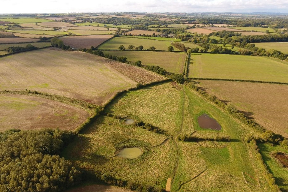
Photograph from a drone of the Evenlode catchment - showing a nutrient retention pond and a field corner flood storage area.
Mainstreaming NFM - next steps
Lessons learnt
This evaluation has drawn out the learning from the NFM Programme which will be instrumental to mainstreaming NFM in the future. This learning has been applied to shape current and future work to mainstream NFM; a commitment in the FCERM Strategy. The learning has shaped the series of associated actions in the FCERM Strategy Roadmap. This will ensure that the learning from the NFM programme is embedded in the current and future work of the Environment Agency and partners.
Strategic context
In September 2020, parliament adopted the Environment Agency’s Flood and Coastal Erosion Risk Management Strategy. The Strategy sets out a vision of a nation ready for, and resilient to, flooding and coastal change – today, tomorrow and to the year 2100. It includes strategic actions which will achieve its ambitions. These actions are supported by measures, which can be used to monitor progress.
The learning from the NFM Programme supported the development of the FCERM Strategy. The Environment Agency recognised the barriers to NFM project delivery, and what was needed to address them.
Measure 1.4.2 captures this:
From 2021 risk management authorities will work with catchment partnerships, coastal groups, land managers and communities to mainstream the use of nature-based solutions.
Greater use of NFM is also a feature of the government’s Flood and Coastal Erosion Risk Management: Policy Statement, which commits to:
The power of nature will be part of our solution to tackling flood and coastal erosion risks. We will double the number of government funded projects which include nature-based solutions to reduce flood and coastal erosion risk.
Mainstreaming NFM through the FCERM Strategy Roadmap
The Environment Agency has come together with a wide range of partners to develop a Roadmap to 2026. It sets out the practical actions we will collectively take to achieve the ambitions, strategic objectives and measures in the FCERM Strategy. This includes how the Environment Agency will work with partners to mainstream NFM and account for the lessons learnt from the NFM Programme. These actions build on the learning from the NFM programme.
The FCERM Strategy Roadmap actions include:
Building the evidence:
The Environment Agency will update its Working with Natural Processes Evidence Directory (for England, Scotland and Wales). It will provide evidence and best practice to help mainstream the use of NFM projects
Enabling investment:
Risk management authorities will double the number of NFM projects delivered as part of the FCERM investment programme. As well as flood resilience benefits, these projects will deliver multi-beneficial outcomes including:
- improving biodiversity
- contributing to cleaner and healthier rivers
- providing carbon sequestration
Partner collaborations:
The Wildfowl & Wetlands Trust will collate evidence and case studies to demonstrate the wider climate benefits of NFM and blue wetland habitats. This will draw on ongoing Wildfowl & Wetlands Trust projects as well as the Blue Recovery campaign. This is seeking to create 100,000 hectares of wetland across the UK.
The Construction Industry Research Information Association (CIRIA) published an NFM manual in May 2022. This provides information about NFM measures and how to deliver them. It is aimed at:
- RMAs
- landowners and land managers
- Rivers Trust and other eNGOs
- community groups and catchment partnerships
Better data recording:
The Environment Agency will work with partners, including CaBA, Blueprint for Water and Natural England, to develop options for better recording data and information from NFM projects. This will help to monitor and evaluate the effectiveness of NFM projects over time.
Streamlining appraisal:
The Environment Agency will continue to enhance its appraisal guidance for flood and coastal erosion risk management projects, in line with government policy. This is so that it reflects the latest climate science and better enables a wider range of smaller, more complex resilience projects including NFM.
Skills and capabilities:
The Environment Agency will work with partners including CaBA, Natural England and eNGOs including Blueprint for Water to ensure all RMAs have access to training and development to deliver more nature-based solutions.
Influencing land use policy:
Risk management authorities will work with partners on Local Nature Recovery Strategies to identify where actions for nature could benefit flood and coastal risk management.
The Environment Agency and Natural England will also support Defra with the development and piloting of the Environmental Land Management Schemes. This will take place through the Local Nature Recovery scheme and the Landscape Recovery scheme, to maximise opportunities for nature-based solutions. This includes developing evidence to support place-based mapping tools which will indicate NFM opportunities in rural areas. This will inform the development of Environmental Land Management Schemes.
Long term investments:
The Environment Agency will produce new long-term investment scenarios which will provide an economic assessment of future flood and coastal erosion risk management for the next 50 to 100 years in England. This will include an assessment of investment needs for nature-based solutions.
Innovation:
The Environment Agency/Defra £150 million Flood and coastal resilience innovation programme will enable Local Authorities, businesses and communities in 25 places to test and demonstrate innovative practical resilience actions. For example, in Cumbria there will be trialling of how Catchment Sensitive Farming Officers can work with farmers and local communities to co-design NFM opportunities. In York & North Yorkshire Catchment Flood Management, there will be testing of how catchment-scale NFM can create wider benefits to downstream beneficiaries.
Annex A: NFM projects within the programme, and their original and final allocations
Catchment programme
| Project Name | County/Area | Original Allocation (£k) | Final Allocation (£k) |
|---|---|---|---|
| Alconbury Brook Flood Management Scheme | Cambridgeshire | 100 | 175 |
| Bacton Sand Engine | Norfolk | 120 | 120 |
| Clothworkers Wood - Wet Woodland Flood Storage Scheme | Royal Borough of Greenwich | 150 | 137 |
| Cumbria Flood Action Plan Small Projects | Cumbria | 2,503 | 2,503 |
| Dartmoor Headwaters | Devon | # 835 | 835 |
| Dorking FAS | Surrey | 300 | 300 |
| Evenlode NFM/WFD Project | Oxfordshire | 20 | 50 |
| Interventions across East Suffolk & Norfolk | Essex, Norfolk Suffolk | 330 | 400 |
| Marine Pioneer - North Devon – Taw Torridge | Devon | 100 | 100 |
| Marine Pioneer – Suffolk – Slaughden | Suffolk | 50 | 15 |
| Medway | Kent | 300 | 300 |
| North Yorkshire - Backstone Beck | North Yorkshire | 167 | 217 |
| North Yorkshire - Brompton | North Yorkshire | 167 | 167 |
| North Yorkshire - Upper Ure / Bishopdale | North Yorkshire | 167 | 167 |
| Radcliffe and Redvales | Greater Manchester | 626 | 626 |
| River Lugg and Wye Integrated | Herefordshire | 626 | 671 |
| River Soar Tributaries | Leicestershire | 626 | 626 |
| Shipston | Warwickshire | 100 | 150 |
| Shropshire Slow the Flow - Severn Tribs | Shropshire | 626 | 626 |
| Slow the Flow delivery in GMMC | Greater Manchester, Cheshire, Derbyshire | 1,000 | 1,000 |
| Swaton Flood Resilience Scheme | Lincolnshire | 793 | 781 |
| Tidal Flood Management and Saltmarsh in the Suffolk estuaries | Suffolk | 90 | 13 |
| Weardale NFM Demonstrator | Northumberland | 2,086 | 2,086 |
| Williton, Monksilver and Doniford Catchments | Somerset | 400 | 400 |
| Wootton Brook | Northamptonshire | 250 | 296 |
| Worcestershire Avon/Cotswold Escarpment Tributaries | Worcestershire, Gloucestershire, Warwickshire | 500 | 540 |
Community programme
| Project Name | County/Area | Original Allocation (£k) | Final Allocation (£k) |
|---|---|---|---|
| Bishop’s Wood | Hertfordshire | 14 | 17 |
| Bourne Rivulet Restoration & Flood Management | Hampshire | 50 | 68 |
| Collingham Beck | West Yorkshire | 50 | 50 |
| Derwent Villages | North Yorkshire | 50 | 50 |
| Dunston Floodplain Reconnection | Lincolnshire | 50 | 0 |
| Fillongley & River Bourne | Warwickshire | 48 | 48 |
| Havergate & Orford | Suffolk | 50 | 50 |
| Hawden Stream | Kent | 10 | 10 |
| High Rogerscale Floodplain Reconnection | Cumbria | 30 | 30 |
| Kenwith Valley | Devon | 50 | 50 |
| Lowdham | Nottinghamshire | 50 | 61 |
| Lower River Crane Restoration | Hounslow | 50 | 55 |
| Management of A33 Surface Water Run-off, Swallowfield | Hampshire | 50 | 31 |
| Northey Island Saltmarsh Regeneration | Essex | 43 | 43 |
| Ottery St. Mary | Devon | 50 | 70 |
| Pang Valley | West Berkshire | 50 | 50 |
| Papermill Dyke | South Yorkshire | 50 | 50 |
| Pymmes Brook Deculverting | Barnet (London) | 50 | 50 |
| Rise Park Stream | Havering (London) | 50 | 50 |
| River Leck Catchment | Buckinghamshire | 50 | 50 |
| River Pinn Park Woods | Hillingdon (London) | 50 | 50 |
| Salmons Brook | Enfield (London) | 50 | 50 |
| Slowing the Flow – Upper Dane | Cheshire East | 50 | 50 |
| Slowing the Flow – Upper Dean Catchment | Cheshire East | 50 | 50 |
| SuDS in Sutton Schools | Sutton (London) | 50 | 92 |
| Midgelden Brook | West Yorkshire | 50 | 50 |
| Twyver Catchment | Gloucestershire | 50 | 80 |
| Upper Piddle Headwaters | Wessex, Dorset | 50 | 50 |
| Upper Thames Catchment | Gloucestershire | 50 | 50 |
| Wallington Catchment Management Scheme | Hampshire | 50 | 50 |
| Woodland & River Management in two Headwater Streams | Harrow (London) | 50 | 75 |
| Wyre | Lancashire | 50 | 80 |
| Yarrow Meadows | Lancashire | 50 | 50 |
| Yazor Brook Flood Alleviation | Herefordshire | 50 | 50 |
Catchment and community allocation funding - totals
| Original Allocation (£k) | Final Allocation (£k) | |
|---|---|---|
| Total Catchment | 13,032 | 13,301 |
| Total Community | 1,595 | 1,710 |
| Total | 14,627 | 15,011 |
References
Environment Agency, 2017. Flood Risk Reduction Benefit Valuation for Natural Flood Management. Economics for the Environment Consultancy Ltd (Eftec). May 2017.
Environment Agency, 2022. Natural Flood Management Advice in Catchment Sensitive Farming: Review of Recording, Modelling and Evaluation Approaches. JBA Consulting.
Acknowledgements
The Environment Agency would like to thank the NFM pilot managers and their wide supporting network of partners, contractors and volunteers for their time, expertise and efforts in project delivery, and their contribution to the learning from the programme.
Thanks also go to the Rivers Trust and CaBA for creating, managing and hosting the NFM Monitoring and Evaluation AGOL tool, which continues to be a valuable resource for capturing NFM measures within the landscape.
There have been many others across the Environment Agency, Defra group and Regional Flood and Coastal Committees (RFCCs) who have supported the programme of works, and helped to steer it to the learning this report showcases.
This report shows there is more we can do to mainstream NFM, and thanks go to all those who are helping to make NFM an everyday choice for all. The work of everyone involved has been inspirational.
List of abbreviations
AGOL: ArcGIS Online
CaBA: Catchment Based Approach
CIRIA: Construction Industry Research Information Association
CSF: Catchment Sensitive Farming
Defra: Department for Environment, Flood and Rural Affairs
EA: Environment Agency
eNGO: Environmental Non-Governmental Organisation
FAS: Flood Alleviation Scheme
FCERM: Flood and Coastal Erosion Risk Management
GiA: Grant in Aid
GIS: Geographic Information System
IDB: Internal Drainage Board
NFM: Natural Flood Management
PSO: Partnership and Strategic Overview
RFCCs: Regional Flood and Coastal Committees
RMA: Risk Management Authority
RSPB: Royal Society for the Protection of Birds
SAFAG: Shipston Area Flood Action Group
SERT: South East Rivers Trust
SuDS: Sustainable Urban Drainage Systems
WwNP: Working with Natural Processes