
Ecological survey and assessment for woodland creation (England)
Updated 13 June 2024
Applies to England

© Crown copyright 2024
This publication is licensed under the terms of the Open Government Licence v3.0 except where otherwise stated. To view this licence, visit nationalarchives.gov.uk/doc/open-government-licence/version/3 or write to the Information Policy Team, The National Archives, Kew, London TW9 4DU, or email: psi@nationalarchives.gov.uk.
Where we have identified any third party copyright information you will need to obtain permission from the copyright holders concerned.
This publication is available at https://www.gov.uk/government/publications/natural-environment-survey-and-assessment-instructions/ecological-survey-and-assessment-for-woodland-creation-england
Read the annexes for this guide on the ecological survey and assessment for woodland creation main GOV.UK page.
Introduction and background
Purpose and scope
This guide:
- describes the minimum standards of ecological survey and assessment required for woodland creation proposals in England
- informs Woodland Creation Proposers (WCPs) how to secure approval for survey work and obtain quotes for the work
- provides information on survey timing and validity
- provides specifications for survey and assessment by ecological consultants/surveyors
Evidence and process of development
The guide draws from various sources of evidence including:
- existing industry guidance – Chartered Institute of Ecology and Environmental Management (CIEEM)
- targeted discussions with specialists – British Trust for Ornithology (BTO), Royal Society for the Protection of Birds (RSPB), Bird Survey Guidelines Group (BSGG)
- research carried out by Napier University and BTO
Where evidence is limited or unavailable, we have sought professional opinion or based guidance on existing practice.
Survey briefs for woodland creation were originally developed during 2020 in conjunction with Natural England (NE), with the lead author Jay Doyle MCIEEM, Ecology Adviser for Forestry Commission (FC). These have been through a process of development reflecting changing guidance (for example, on peat and waders) and evolving industry practice, and the 2023 update has been led by Lisa Kerslake CEcol FCIEEM, FC Area Ecologist for Yorkshire and north-east England. The update was assisted by a steering group and wider consultation was carried out with stakeholders (see Annex 5 for steering group membership and consultation).
UKHab citation and acknowledgement
UK Habitat Classification Version 2.0 UKHab Ltd (2023) used with permission of UKHab Ltd. No onward licence implied or provided and, where applicable, the same shall be out of scope of the OGL v3.0 (and subject to its own licencing terms).
Find further details about the UK Habitat Classification System and full licensing terms.
Other acknowledgements
Read Annex 1.
CIEEM is pleased to endorse this updated guidance as providing minimum standards and good practice for those carrying out survey and assessment relating to woodland creation in England.
Part 1: Essential information for woodland creation proposers and surveyors
Definitions
Woodland Creation Proposer (WCP): the person preparing a woodland creation proposal for approval by the FC. This may be a landowner or their agent.
Surveyor: the person carrying out the required surveys. This is usually an ecologist. The terms ’consultant’ or ’contractor’ may also be used.
About surveys and assessments
When a proposal for woodland creation is received, we will tell the WCP if surveys are needed and will usually provide a map of the area the surveys must cover. This might include a buffer area, which will be determined on a case-by-case basis. Surveys are normally needed in relation to Woodland Creation Planning Grant (WCPG) applications, but may also be required for other types of woodland application.
The most common survey types are peat, habitat/vegetation, and breeding birds, but in some cases additional assessments may be required, for example where the site may support nationally important populations of a species, or species assemblages, such as rare arable plants. If this is the case, we will advise and provide further information as needed.
The survey results will be used to help:
- decide whether a site is suitable for woodland creation
- the WCP complete a woodland creation design plan which protects and enhances existing environmental features
Any significant variation from the survey specification (for example, different methods, fewer survey visits, or deviation from recommended bird survey dates by more than 2 days) must be agreed in advance with the relevant FC Area Ecologist. The survey report must meet the relevant specification(s), or it will not be accepted as evidence about your site.
The specifications will be updated in response to changes in FC or industry survey standards or as new information becomes available. Please make sure you use the most up-to-date version. Table 1 gives guidance on survey timing and other deadlines.
How to get approval for survey work
WCPG schemes
For WCPG schemes, the costs of surveys are grant-aided by FC. The WCP has the option to either provide costings for the proposed survey work through submission of three quotes, or by opting to use the standardised survey rates we have provided for peat, habitat (NVC only) or breeding bird surveys, as detailed in Annex 2.
Note: standard rates are not yet available for preliminary surveys or UKHab surveys. These will be added in due course.
If opting to submit quotes, then you must obtain at least 3 detailed quotes from suitable surveyors (see ‘Choosing Surveyors’) for each survey and send them to us for decision. We must approve surveyors, methods and fees in writing before survey commences. Quotes/tenders will be assessed on:
- the methodology proposed
- compatibility with the specifications
- evidence of competence
- cost
We offer no guarantee that the lowest price or any tender will be accepted. We will seek to secure value for money but also need to be satisfied that the proposer/surveyor has submitted their quote in the required format and has the ability and the experience/competence to undertake the work (see ‘Choosing Surveyors’ section). We are not responsible for costs incurred during the preparation of fee proposals.
If opting to use FC standardised survey rates, then the chosen surveyor must submit their methodology to us in writing for approval before survey work commences. The submission will be assessed on:
- the methodology proposed
- compatibility with the specifications
- evidence of competence
Payments based on standardised survey rates are calculated using a tiered system based on the size of the survey area.
Once we have approved a survey quote, work cannot be subcontracted to another individual or organisation without prior approval from the FC Area Ecologist. Any subcontractors must meet the surveyor specification.
Other woodland creation schemes
For non-WCPG schemes there is no need to submit quotes, as grant aid is not provided. However, the surveys and surveyors must meet the specifications provided in this document.
Choosing surveyors
The survey must be carried out by suitably qualified, experienced, and professional contractors. They must have demonstrable experience of competence in relation to the survey and assessment work described in the specifications. They should be a professional grade member (that is, a grade that has been subject to independent assessment/peer review) of a relevant professional body with an appropriate code of conduct and disciplinary inquiry procedure (for example, CIEEM).
In exceptional circumstances the survey may be undertaken by surveyors who do not hold an appropriate level of membership of a professional institute. These will be considered on a case-by-case basis, and a justification, including evidence of qualifications, competence, and experience of previous similar work, must be submitted with the proposed costing for the survey work. It will be expected that their work is reviewed by an appropriately qualified person who does hold such a membership. This exception will not apply to in-house surveyors (see below).
Each specification lists any additional skills and experience required by surveyors.
In-house ecological surveyors
Where applicants and/or proposers have in-house ecological resource, this may be used to undertake the necessary survey and assessment only in the following circumstances:
- the ecologists undertaking the work must be full members (or equivalent) of an appropriate professional body (for example, CIEEM) and appropriately qualified, experienced and competent in the work required
- the survey and assessment must be carried out in accordance with our published specifications
In the case of the applicant/proposer being a National Park/Area of Outstanding Natural Beauty/Local Authority, please contact your local FC team to discuss further.
Notes:
- where in-house ecologists are used, payment will be made using the standardised survey costs detailed in Annex 2
- because of the potential for conflicts of interest, the requirement for professional membership cannot be waived
- if you are uncertain about the requirements, please contact your FC Area Ecologist
Quotes for the work
Using the templates in the annexes, each contractor must prepare a quote that details:
- how the survey specification will be fulfilled, for example, a method statement demonstrating how the work will be undertaken, any risks to delivery and measures to address risks identified
- staff involved in undertaking the survey and reporting
- all contributors’ professional expertise and track record in comparable projects
- all contributors’ professional indemnity, public liability and employer’s liability insurance
- report review/quality control/assurance measures to be used by the contractor
- a proposed timeline for the survey including project set-up, desk study, fieldwork, assessment of impact and reporting stages
Where the option to provide quotes has been taken, potential contractors must also:
- itemise costs using the standard pricing schedule (Annex 3)
- include day rates for all experts involved (Annex 4)
- propose fixed costs
- indicate whether VAT will be added to the total cost
- identify any contingency items for unknowns or additional work deemed appropriate
- consider all relevant legislation, regulations, and best practice, including the Wildlife and Countryside Act 1981 and the Health and Safety at Work Act 1974
Each quote should comprise a method statement and fixed-price fee proposal for the survey. Quotes that do not include the pricing schedule will not be considered.
If quoting for more than one survey, a separate quote must be prepared for each survey. A separate statement should be prepared showing any cost savings applicable if all survey work quoted for is awarded.
When using our standardised survey rates, the potential contractor does not need to complete either Annex 3 ‘Pricing Schedule’ or Annex 4 ‘Day Rates’, but must consider all relevant legislation, regulations, and best practice, including the Wildlife and Countryside Act 1981 and the Health and Safety at Work Act 1974.
Existing environmental information
You must share any environmental information already gathered about the site with prospective contractors, including data searches/desk studies, peat surveys and any previous ecological surveys undertaken whether related to the current proposal or not.
Brief notes from initial assessments from NE/FC staff, if available, can be provided to contractors on request.
Other survey considerations
Access to land not in applicant’s ownership (for example, buffer areas for bird surveys)
The WCP must obtain permission to access and survey all land within the survey area. This means:
- you must make reasonable attempts to identify and contact all the owners of land where survey work is required. You will need to explain your proposals and obtain permission from them to carry out the survey. (You can ask your contractor to do this, but they may not be willing, and are likely to charge extra for doing so)
- any such landowners will also need to give permission for any ecological records collected as part of the survey to be passed on to the Local Ecological Records Centre (LERC) (no personal information is included)
If it has not been possible to obtain access permission for some of the survey area you must contact us to discuss. In this situation:
- it may be possible to use roads or public footpaths to carry out surveys if there is sufficient coverage. This is subject to legal restrictions and must be agreed with us beforehand. (For legal reasons, open access land under the Countryside and Rights of Way Act 2000 (CROW Act) cannot be used for this purpose)
- where there is insufficient public access to enable adequate survey coverage, we may have to make a decision on the likely ecological value of the inaccessible land. This will be done in consultation with NE and will be based on factors such as habitat suitability, the BTO wader zonal maps, botanical heat mapping and any other existing records
- in the absence of recent survey information, decisions on ecological value will be precautionary
In all cases where full access permission is not forthcoming, you must supply evidence of reasonable effort to obtain such permission.
Management of land subject to survey
You must consult us about any land management or recreational activities taking place prior to or during the survey (for example, placing of markers, cutting, topping, drainage, vegetation clearance or the introduction of grazing) that might affect the survey. These may reduce survey effectiveness, invalidate the results and lead to delay or withdrawal of associated grant offers.
It is strongly advised that cutting, topping or grazing is temporarily ceased before bird or habitat surveys start. If possible, this should include the removal of cattle or sheep from the survey area until surveys are complete. Topping should not be carried out after mid-February and before the end of August, as set out in the Upland Management Handbook SC26.
Surveyors are obliged to note any changes in vegetation management or other activities on site which may affect the assessment (for example, habitat clearance, introduction of grazing, cutting for hay or silage). Recent and historic aerial photography may aid in the assessment of such changes.
Seasonal constraints and lead-in time for ecology surveys
Ecology surveys nearly always have restrictions on the time of year that they can be carried out and will also require time to arrange. If the application or initial enquiry is received during or only shortly in advance of the start of the survey period, then there is a high risk that the survey will not get completed until the following year. Ecological consultants become extremely busy at certain times of year and the timings reflect this.
Table 1 below provides ecology survey timings and the date by which you need to have obtained advice on whether a survey is required. You can find further advice on vegetation survey timings at Designing a new plant surveillance scheme for the UK (JNCC Report No. 440).
We are reasonably confident that the dates given allow time for the survey to be completed in the following survey season, provided there are no other timing constraints, such as the need to receive an offer of WCPG Stage 1 or a Supplementary Payment where this is made before a WCPG Stage 1 offer.
Reporting requirements
Following the survey fieldwork, the contractor must prepare a report to the specified requirements, detailed in Part 2.
Template/checklists are now available for Habitat/Vegetation and Breeding Bird surveys. These can be found in Annex 10 for rationale).
Survey validity
Ecological surveys and reports may only remain valid for a limited period. We generally use the CIEEM Advice note on the lifespan of ecological reports and surveys as a guide. However, decisions may be made on a case-by-case basis depending on factors such as site management and the subject of the survey.
Table 1: Survey periods and deadlines
| Survey type | Timing | Deadline for opinion on whether survey is needed |
|---|---|---|
| Upland breeding birds (including waders) | March to July (mid-June for waders) | 15 December of preceding year |
| Vegetation/habitat (NVC/UKHab) and Preliminary Habitat Assessment | Optimal period May to August, preliminary period April to October | 15 March |
| Peat | Any time of year | No restriction |
| Invertebrates | Varies, but mostly spring and summer | 1 February |
| Lowland waders | Breeding March to mid-June, wintering peak October to March | Variable |
| Bespoke plant / lichen / fungi survey | Depends on habitat | Variable |
| Other surveys | Variable |
Table notes:
- upland breeding bird surveys must start in March and follow dates specified in this guidance
- timing of habitat survey depends partly on habitat type and area (flowering periods are later further north). A single survey early or late in the season may not be adequate. Woodland ground flora should be surveyed mid-April to early June, most other habitats late May/June to August/early September. Heath/bog may be possible to survey outside this period provided not in a mosaic with other habitat types. A graph showing the reduced effectiveness of surveying outside the optimal period is given in Annex 6
- it is helpful to provide the peat survey in advance of habitat survey, if possible
- Buglife has basic survey advice for invertebrates, but FC’s opinion must be sought
- some lowland wader sites are important for non-breeding rather than simply wintering. Surveys must be timed accordingly
- see Annex 5 for bespoke plant/lichen/fungi survey method
- if other ecology surveys are needed, you will be advised by the FC Area Ecologist
Submission to Local Environmental Records Centre
It is a condition of the grant that digital copies of ecological data, including species records and spatial habitat data, are submitted to the relevant LERC. We will carry this out on receipt of final reports. You will need to supply us with contact details for the relevant LERC by completing Part 2b ‘Supplementary Payment for an Ecological Survey’ on either the Stage 1 or Stage 2 WCPG claim form (version 8 or later).
Assessment of survey results
Once an acceptable survey report has been received (see Part 2 General Requirements/Reporting) the FC Area Ecologist will assess the results in discussion with the relevant Woodland Officer (WO)/Woodland Creation Officer (WCO). Where the results are uncertain or marginal, for example habitat types that are difficult to distinguish or calculations very close to a threshold, other information and professional judgement may be used to come to a conclusion. Discussion with other bodies (for example, Natural England, National Park Authorities) may also be necessary, but the decision rests with FC as the Regulator.
Biosecurity
We expect all surveyors to follow established biosecurity protocols, thoroughly cleaning all equipment, such as footwear between site visits to reduce risk of the spread of disease or invasive non-native species.
Find out more on how to prevent the spread of tree pests and diseases.
Part 2: Survey specifications
General requirements
This section outlines the ‘general requirements’ applicable to any survey, which must be read in conjunction with the additional requirements in the survey specifications that follow. Each survey specification lists any additional skills and experience required by surveyors.
Work cannot be subcontracted to another individual or organisation without prior approval from the FC Area Ecologist. All subcontractors must meet the surveyor specification.
Specifications will be updated in response to changes in standard survey protocols/ methods and updated here.
Desk study
The WCP must pass to the contractor any ecological information known or obtained about the site and adjoining land, including data searches obtained from the LERC or other bodies. The contractor must review, collate and evaluate any such information for inclusion in their report. If a desk study has not been undertaken, this must be carried out as part of the contractor’s work.
Desk studies must include (but not necessarily be limited to):
- a review of current and historical Ordnance Survey (OS) maps/aerial photographs for the site and adjoining landscape to identify areas of interest, habitat connectivity, likely drainage patterns and landscape character
- reference to the MAGIC interactive map[footnote 1] to identify relevant statutory sites, known and mapped peat, priority habitat[footnote 2] and species in and around the proposal
- information from the LERC, including local wildlife sites and other relevant information for an appropriate radius (minimum 1 km) from the site boundary (and buffer, if applicable)
The additional desk study information required for a peat, habitat or bird survey desk study is included in the relevant survey specification.
You must interpret the data search fully and provide maps that show the location and age of the records for any key species or sites, in relation to the site to be surveyed, and take account of any caveats supplied with data regarding its accuracy and completeness.
Field work
The results of the desk study may indicate that a larger survey area than originally planned is needed, for example if there are features of interest in areas immediately adjoining the footprint of the proposal that might be affected. You must agree any additional survey work with us in advance.
The WCP may not own all the land affected by the proposal. You must have permission from landowners to visit the survey area (see Access to Land).
You must follow the survey specifications, unless we have agreed alternatives in advance. Surveys should be carried out under suitable weather conditions. GPS should be used to pinpoint locations and measure distances where appropriate.
You must record any changes in vegetation management or other activities on site which may affect the assessment.
You should also record any other ecological constraints evident on the site that have not been specifically surveyed for, for example badger setts or other evidence of protected species. However, there is no requirement to carry out a Preliminary Ecological Appraisal or similar assessment unless that has been specifically requested.
Reporting
The report must be subject to quality assurance (QA), including a technical review by a competent ecological practitioner. They should be a professional grade member of a relevant professional body with an appropriate code of conduct and disciplinary inquiry procedure (for example, CIEEM). Sole traders must arrange for this to be carried out by a suitable external reviewer and include the cost in their quote.
The contractor must share the draft report in Word format with us for comments and amendments (they may need to temporarily compress pictures to reduce file size). We will review the report and provide feedback if any amendments or additional information is needed. The contractor must make any necessary revisions to the document and resubmit. No additional costs for amendments will be paid unless we have agreed them in advance.
We will confirm when the report meets the standard and is complete.
The evaluation/assessment required for each survey type is given in the survey specifications that follow. Where more than one survey has been undertaken, you should include an overall evaluation statement taking account of all identified constraints. Otherwise, the evaluation and impact assessment will generally be carried out by the FC Area Ecologist in consultation with NE as needed, to inform the detailed scheme design.
A summary of general reporting and mapping requirements is listed below. In addition there are specific reporting/mapping requirements for each survey type, which are given in the relevant survey specifications.
All maps must be provided on a large-scale OS base and aerial photo, with appropriate copyright. The cost of these and relevant licences can be included in your quote.
General reporting and mapping requirements
See individual survey specifications for additional requirements.
Format:
Drafts must be provided in MS Word to allow for comment/ amendments.
Reference:
- site name
- central grid reference
- any grant reference number (e.g. WCPG xx xx_xx)
Background and summary information:
- objectives of survey
- site description including adjacent land use
- executive summary
- tabular summary of dates and times of visits, surveyor name(s), weather (wind, cloud cover, precipitation, visibility, temperature) and any other survey conditions
- any areas currently or recently in agri-environment schemes and purpose for which they are being managed
- pre-existing, developing or projected impacts such as recently planted woodland, new construction or other changing land use
Constraints:
- any constraints or limitations to the survey (e.g. access, weather, groundworks), including the reasons for the constraint and its impact on the survey
- any deviation from standard survey method or agreed area
Methods:
- a detailed methodology that can be easily replicated
- timing and duration of surveys
- surveyor roles and experience
- any industry standard guidance followed
Results:
- results of desk study, fully interpreted
- results of field work
Evaluation:
- assessment of quality of features of interest (e.g. priority habitat)
- where required, brief assessment of likely impact of woodland creation (as indicated in survey specifications) with reference to type of woodland intended
- clear explanation and justification from evidence collected/presented
Maps/plans:
- to be provided on a large scale OS base and aerial photo, with appropriate copyright.
- to be included in reports and provided as GIS shapefiles
- included in reports at a large enough scale to be legible without having to refer to shapefiles (this may necessitate subdividing maps for clarity)
- cross referenced to text
- site and buffer (where applicable)
- habitats, topography and land use
- any areas not visible or not accessed
- survey sampling locations (e.g. transect, vantage point, quadrat, peat depth probe)
- GIS shapefiles to be provided for all maps/plans
Photographs:
- cross referenced to text
- key features e.g. priority habitat
- aerial photos to support mapped information
Supporting information and additional requirements:
- where a buffer is included, report separately on woodland creation site data and any buffer data and make clear whether statements refer to planting site, buffer or both.
- avoid terms like ‘small number’, ‘close proximity’, ‘many’ – be specific
- raw survey data in separate MS Excel format detailing date, name of recorder, species, OS Grid reference and any other information
- any additional observations on species or habitats
- opportunities to enhance habitat connectivity for both wooded and non-wooded habitats e.g. via Local Nature Recovery Strategies
Ownership (copyright and intellectual property)
The appointed ecological contractor (and their subcontractors) will agree to:
- grant to FC an irrevocable, perpetual and royalty-free licence to use, copy, keep and disseminate the Outputs as they see fit and to grant sub-licences of the same kind
- obtain and maintain in force all authorisations of any kind required for you to use, copy, keep and disseminate the Outputs and to grant such licence to FC
- contract to the effect that any creation by you or on your behalf of material which forms Outputs is undertaken on terms that either the copyright in the material is assigned to you or that the copyright owner may not commercially exploit it
- grant licences in respect of the Outputs under the Creative Commons model licence ‘Attribution Non-Commercial’ but not on other terms without our prior written consent
- not otherwise exploit Outputs commercially without prior written consent from FC
We may share the data or report with Natural England or other relevant bodies in line with agreed joint operational guidance.
The data and report may be used by Defra and related bodies (for example, FC and NE) to add to or inform environmental data sets and modelling.
Scoping and specialist surveys
Scoping surveys
In certain circumstances scoping surveys may be advisable to define the scope of a specialist survey by identifying key constraints at an early stage and/or reducing the area over which specialist surveys are required (that is, ’scoping out’).
Scoping surveys are generally only used where they are likely to reduce overall costs, mainly where sites are large or complex and where there is a long lead-in time. They should not be used if they are likely to delay specialist survey until the following year.
Your WCO/WO/FC Area Ecologist will advise whether a particular scoping survey is needed. Any funding for scoping surveys will be based on quotes.
Preliminary Ecological Appraisal
This is a standard CIEEM survey and report format which may be required on sites where there are likely to be multiple ecological constraints over and above peat, habitat and breeding birds. You should follow CIEEM’s guidelines for Preliminary Ecological Appraisal (GPEA).
Preliminary Habitat Assessment
This is typically used on large or complex sites with numerous vegetation types, but where wider ecological constraints (other than peat and breeding birds) are unlikely. A survey specification can be found in section 12.
Peat and Breeding Birds
There is currently no standard specification for scoping surveys for peat or breeding birds. If needed, your WCO/WO/FC Area Ecologist will provide site-specific advice.
Note: Scoping surveys may not automatically be eligible for payments via WCPG supplementary payment system. Please check with your WCO. We will keep the use of scoping surveys under review to assess their efficacy and cost-effectiveness.
Other specialist surveys
In some cases additional specialist surveys may be required, for example for invertebrates, lowland wading birds, dusk bird surveys, or bespoke plant, fungi or lichen surveys. Where this is the case you will be advised by the WCO/WO/FC Area Ecologist. A general method for a bespoke plant, fungi and lichen survey is included in Annex 5. (A tailored application of this method for rare arable plants (for illustrative purposes) will be provided in due course). Bespoke botanical surveys may be required in other situations, typically for anthropogenic habitats where botanical value is not well characterised by standard vegetation survey techniques, for example, ex-quarry or brownfield sites. Bespoke fungi surveys may be required in some instances, for example, for determination of waxcap grasslands.
Peat survey and assessment specification
This specification is additional to the general requirements. It is specific to peat surveys and should be read in conjunction with the general guidance above and with the Decision Support Framework for peatland protection.
Additional qualifications and experience
Surveyors should provide evidence of recent experience of undertaking peat depth and condition survey (usually gained within the last 3 years, but may be extended to allow for Covid 19 restrictions).
Additional desk study and data search
In addition to the general requirements, you must collate information from:
- the UK Soil Observatory to access the ‘British Geological Survey’ (BGS) peat coverage map layers (surface body layer) under the ‘soil type’ tab
- LandIS Land Information System
- the Soils Site Reporter report
- the Local Ecological Records Centre and any other suitable organisation
Additional useful information may be available from:
- geology maps (impermeable bedrock/drift geology may reflect areas of peat)
- LIDAR data, which may indicate where trees are upstream or downstream from peat
Lowland fen and wasted peat sites
This section relates only to cultivated areas of fen or wasted peat.
For lowland fen peat, we will verify whether a soil survey or peat survey is required.
For wasted peat, a peat survey will not be required if it can be demonstrated that soil organic matter content is consistently less than 30% across those parts of the site proposed for woodland establishment. Wasted peat is a technical term for once deep peat that has been substantially degraded following many years of drainage and cultivation so that any remaining peat is now more dominated by mineral material.
Soil sampling to test for peat organic matter
Sampling should take place in each area identified as peat and proposed for planting. To avoid sampling just the most degraded top 30 cm, soil samples need to be taken to a depth of 1 m or to the maximum depth of the peat, whichever is shallower. To obtain a good representation of the area of peat, individual cores need to be taken from the entire profile of the peat, that is, from each core, and where identifiable you should take a sample from each distinct peat horizon. We will agree the number of samples prior to survey commencing.
These cores should be taken by walking the field in a ‘W’ or other representative pattern and taking cores from equally spaced sampling points, the distance apart depending on the field size. It is important to spread the sampling points evenly over the site, and away from edge of the area identified as peat and proposed for planting. From each core, you should take a sample from the entire depth of the peat sample up to 1 m.
If there are clear undisturbed layers of mineral soil within the 1 m sample, this material should be excluded from the sample. Samples should be kept separate, clearly labelled and sent for a loss on ignition test, in pre-arranged packaging, to a UKAS accredited lab (or one following the relevant British Standard, such as BS EN 15935:2021). You should note the georeference and depth of the peat at the sampling point.
Peat survey samples must be taken by a surveyor qualified with BASIS or FACTs, or with suitable alternative experience and professional body membership.
Any areas where organic matter content is greater than 30% in the top 1 m of peaty soil horizons will be excluded from planting unless these areas have peaty soils of less than 30cm in depth. A full peat depth survey may be needed to evidence the latter.
Where narrow peat lenses are associated solely with watercourses and not a wider distribution of peaty soils, further investigative survey work will not be necessary.
All other peat sites[footnote 3]
Field survey method
You will need:
- a peat corer, at least 1 m long. Alternatively, you should use either an auger or a spade to dig sample pits, together with a peat depth probe if needed
- a GPS device to record the sampling locations
- tape measure
- data recording forms
- Peatland Condition Assessment guide
- digital camera
Before you start
Before you measure depth, ensure you are confident that peat is being tested, not just wet ground, by using a corer or pit sample.
The survey should cover land within the area identified as likely to contain peat, as agreed with us. Flexibility may be needed to pick up specific locations such as flushes and small valley mires. Before you start, make sure you:
- mark a 50m x 50m grid on a map and aerial photograph
- plan your route to enable the crossing of ditches and other obstacles
- carry out a risk assessment and include risks from powerlines and very wet ground
Where the standard 50m x 50m spacing cannot be achieved, for example within cloughs and other areas less than 100m in width, an alternative sampling method may be needed. For cloughs the following spacing should be used: 20m x 20m samples at the top of the clough, halfway down the slope, and at the bottom, at 20m intervals along the length. Locations/intervals to be assessed in each clough. Describe and justify your methodology for cloughs or other small areas.
In a limited number of sites, a 100m x 100m survey grid may be more suitable, for example on very large peatland sites. A bespoke survey design may be required for some sites. You must agree any variation in the standard method with us in advance.
In the field
At each intersection of the 50 x 50 m grid:
- record the sampling date and time
- record the sample point and identification reference (for example, A1, A2…)
- record the position using GPS and give a 10-figure OS grid reference
- push the peat probe in until it comes to a halt, or you feel additional resistance. (The perception of resistance may vary between surveyors. If you are unsure, it may be necessary to dig a sample pit or use an auger)
- mark or note the surface level on the probe and remove it
- measure and record the length of the probe to the surface mark, to the nearest cm
- record comment or observation (if appropriate)
- record peatland condition category using the Peatland Condition Assessment Guide if appropriate (for example, blanket bog)
Notes on survey method:
The exact position of the probing point is more important than the grid position. An accurate grid reference of the actual probing point is critical to allow accurate mapping of the peat resource.
Ground conditions or access may restrict access to the exact grid point. It needs to be representative of the surrounding locality and represent the depth of peat at this point (for example, not in a hollow or hummock of peat). Where individual probe locations are unrepresentative of the surrounding habitat, they should be relocated and georeferenced to more representative sample points.
Wood and tree remains preserved in the peat may affect the depth at which the probe stops. Where the peat depth unexpectedly appears shallower, it is advisable to probe a metre or so away from the original probe point.
FC has published guidance on classifying soil types for planting, which is a requirement for EWCO. In particular, see Appendix 2 - Classifying Agricultural Soils for use in Woodland Creation Grant.
Condition categories
To assess the peatland condition category at each probe point, use the Peatland Condition Assessment Guide, which includes descriptions and photographs of the four condition categories:
- near natural
- modified
- drained
- actively eroding
If the site has been previously afforested or if there is evidence of peat cutting, this should be noted in addition to the standard categories.
Reporting
In addition to the general reporting and mapping requirements, the field survey results must be provided in Excel (for example, a modified version of the Peatland Action Excel template). You must also provide the data in GIS shapefile format, including the attributes in the Excel template.
You should also include:
- total number of points surveyed
- the model of GPS device and estimated accuracy during the survey
Maps of areas surveyed, peat depth and peatland condition must be produced. The maps need to show the depth recorded at each point on the grid and interpolated peat depth layers (see Figure 1).
The peat mass within the proposal area and any buffer should be mapped in its entirety (from 10 cm in depth upwards). This will show the spatial arrangement and functional connectivity between deeper and shallower areas of peat.
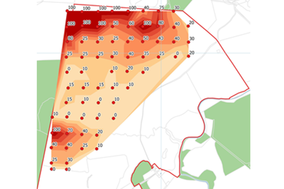
Figure 1 – Example map showing peat resource with peat depth sampling points labelled with corresponding peat depth in cm.
Evaluation and impact assessment
For this you need to:
- assess and make recommendations about the suitability of the site for woodland creation including an assessment of the likely impact of woodland creation on the peatland resource. This should include indirect effects such as hydrology and seeding of trees. You must use the Decision Support Framework for peatland protection to help with evaluation, and justify your conclusions accordingly
- produce a map showing areas of peat that should be excluded from woodland creation or buffered from any adjacent woodland establishment. In some instances, native woodland planting could stabilise an eroding peatland edge. This would be assessed on a case-by-case basis and would need to be carefully considered in relation to the Principles for Afforestation on or near Priority Habitats
No other evaluation, impact assessment or consideration of mitigation/compensation is required.
Preliminary habitat assessment specification
This specification is a discretionary requirement. It is additional to and should be read in conjunction with the general requirements. Variation in this method may be acceptable but must be agreed in advance with the FC Area Ecologist.
The purpose of the Preliminary Habitat Assessment (PHA) is to determine broad habitat types and to collect sufficient information to justify ‘scoping out’ certain habitats (such as those of low conservation value or unsuitable for afforestation) from more detailed habitat/vegetation survey. PHA should use a recognised habitat survey classification, such as UKHab, in sufficient detail to determine the likely presence of priority/Annex 1 habitats, or degraded habitats with potential to be restored to priority habitats. You should undertake PHA using a combination of desk- and field-based survey.
The FC Area Ecologist will determine the use of PHA, in consultation with NE where appropriate. It will only be used where it is likely to be cost effective and not lead to significant delays to more detailed survey. For example, on large or complex grassland sites its use may significantly reduce the total area requiring detailed survey.
Additional qualifications and experience
Surveyors must be able to:
- demonstrate experience of survey (for example, NVC, UKHab) at an appropriate level of competence for the habitat. This means having sufficient botanical skill to identify key Priority Habitat (PH) indicator species, for example holding a Field Identification Skills Certificate (FISC) level 4
- accurately identify vegetation stands that do not form PH and distinguish them from those that are or might be PH, pending specialist survey
- prepare accurate maps
Survey and reporting
Surveyors must:
- visit all parts of the site to enable accurate assessment of broad habitat types (see Table 2), such that no significant areas of potential PH are missed
- clearly identify and map areas to be included in/omitted from subsequent specialist survey
- provide descriptions of the habitat and species in omitted and included areas, including current management
- identify and map practical boundaries for areas needing further survey using field boundaries, even if this means including small areas of non-PH. If there are no field boundaries, use straight lines identified using existing features (for example, gates, stiles, ditches) so that these can be easily followed by the NVC/UKHab surveyors in due course. Shapefiles/GPS coordinates should be provided.
Table 2 – PHA – Broad Habitat Types and requirements for further survey
| UKHab Level 3 code | UKHab Level 3 – Broad Habitat Types | Further survey requirements |
|---|---|---|
| (UKHab Levels cited, but NVC survey to sub-community, can also be used, where appropriate) | ||
| g1 | Acid grassland | Detailed habitat survey to at least UKHab Level 4 to identify priority habitats |
| g2 | Calcareous grassland | Detailed habitat survey to at least UKHab Level 4 to identify priority habitats |
| g3 | Neutral grassland | Detailed habitat survey to at least UKHab Level 4 to identify priority habitats |
| g4 | Modified grassland | May be excluded from further survey, subject to confirmation of absence of other habitat complexes or features of conservation value, see following section |
| w1 | Broadleaved and mixed woodland | Detailed habitat survey to at least UKHab Level 4 to identify priority habitats |
| w2 | Coniferous woodland | May be excluded from further survey, subject to confirmation of absence of peat and other habitat complexes or features of conservation value, see following section |
| h1 | Dwarf shrub heath | Detailed habitat survey to at least UKHab Level 5 to identify priority habitats and Annex 1 habitats |
| h2 | Hedgerows | May be excluded from further survey |
| h3 | Dense scrub | Detailed habitat survey to at least UKHab Level 5 to identify priority habitats and habitats of high conservation value, for example Atlantic hazel and west coast blackthorn scrub |
| f1 | Bog | Follow peat survey guidance and refer to Decision Support Framework for peatland protection. Detailed habitat survey to at least UKHab Level 5 to identify priority habitats and Annex 1 habitats |
| f2 | Fen marsh and swamp | Follow survey guidance for Peat and refer to Decision Support Framework for peatland protection. Detailed habitat survey to at least UKHab Level 5 required to identify priority habitats and Annex 1 habitats |
| c1 | Arable and horticulture | May be excluded from further survey, subject to confirmation of absence of peat and other habitat complexes or features of conservation value, see following section. |
| u1 | Built-up areas and gardens | May be excluded from further survey, subject to confirmation of absence of peat and other habitat complexes or features of conservation value, see following section |
| s1, s2, s3, r1, r2, t1, t2 | Various – inland rock, coastal cliff, open, standing and running water, intertidal and marine | Many of these are not suitable for woodland creation and may not need further survey. But where habitats such as calaminarian grassland, inland rock, scree, limestone pavement and maritime cliff are proposed for woodland creation the FC Area Ecologist should be consulted and further survey may be required |
In addition to survey to broad habitat level, additional information should be collected at the PHA stage to determine the presence or potential presence of the habitat complexes of conservation value identified below.
Habitat complexes of conservation value
Juniper scrub on heaths or calcareous grasslands
Stands of juniper scrub often at relatively low densities and in association with other shrubs or trees. Typically, on acid soils in upland/northern England and calcareous soils in southern England, the Yorkshire Dales and Cumbria.
Coastal and floodplain grazing marsh and floodplain wetland mosaic
Periodically inundated pastures and meadows, typically maintained with a drainage ditch network, which may contain standing, brackish or fresh water. Occurs on the coast and river floodplains.
Temperate rainforest
Woodlands and scrub in lowlands near the Atlantic coasts with characteristic, rich communities of oceanic mosses, liverworts and lichens.
Traditional orchards
Open-grown fruit trees within herbaceous vegetation. Orchards that pre-date 1939 are of particular conservation value.
Wood-pasture and parkland
Mosaic habitats typically supporting open-grown veteran and ancient trees, often associated with extensive grazing. Some sites may be associated with historic designed landscapes.
Long continuity habitat
Habitat that is known to have been, or very likely to have been, continuously maintained as that habitat for at least the period specified:
- woodlands – since 1893
- grasslands – since 1936
Open mosaic habitats on previously developed land
Previously developed sites meeting the following criteria:
- greater than 0.25ha in size
- demonstrating history of disturbance
- supporting mosaic of early-successional vegetation indicative of low nutrient status substrates
- presence of bare ground and/or temporary or permanent pools
- shows spatial variation
Waxcap grasslands
Grasslands with rich assemblages of waxcap and other fungi of high conservation importance from the CHEGD group (Bosanquet et al., 2018).
Species-rich grasslands
A grassland (non-priority habitat) that meets 2 of the following:
- greater than 30% cover of broadleaved herbs and sedges (with exclusion 9 common and/or weedy species)
- greater than 15spp/m2
- less than 10% cover of rye grasses and white clover
For good quality semi-improved grassland (GQSIG), please refer below.
Habitat/vegetation survey and assessment specification
This specification is additional to and should be read in conjunction with the general requirements.
The following FC guidance documents provide additional information:
- Principles for afforestation on or near priority habitats
- Priority open habitats and woodland creation: a field guide
Additional qualifications and experience
In addition to the general requirements, surveyors must be able to:
- demonstrate extensive experience of habitat survey, for example, UKHab (2023) or NVC (Rodwell 2006) including methods, survey design and fieldwork
- use cover values (such as DOMIN, specifying cover percentage in each category)
- identify plant communities or sub-communities (UKHab level 4 or 5 or recognised NVC sub-community, depending on habitat) and interpret complex vegetation patterns that may not be an easy fit to recognised habitat and vegetation types
- operate at the appropriate level of competence for the habitat being surveyed, so having sufficient botanical skill to identify key Priority Habitat (PH) indicator species, for example holding a Field Identification Skills Certificate (FISC) level 4
- identify PH types in the context of the area being surveyed, for example, the same NVC type may be considered PH in lowland but not upland areas, or vice versa
- clearly assign vegetation communities to PH types
- demonstrate clear understanding of the significance of potential impact on priority habitat types, including indirect effects (for example hydrology)
- undertake condition assessments using the latest statutory biodiversity metric tools and guides
- prepare accurate habitat maps
Additional desk study and data search
In addition to the general requirements, consider whether further information about the site is needed. You can find additional information from:
- the LERC
- Botanical Society of Britain and Ireland (BSBI) records
- the MAGIC interactive map, including the priority habitat inventory layer (this layer contains inaccuracies and cannot be relied upon, so will need ground truthing) and the summarised botanical value map 2021.
Data searches from LERCs or similar sources must be interpreted fully in the report, including producing maps that show the location and age of records for any key species or sites, in relation to the site to be surveyed.
Desk studies must also assess the following habitat types identified in the Priority Habitat Inventory in MAGIC, to understand habitat composition and condition:
Grass moorland or fragmented heath
Priority habitats may be present within a mosaic of other semi-natural non-priority habitat.
Good quality semi-improved grassland (GQSIG)
May have restoration potential and/or be making an important contribution to ecological networks. It should be treated as an ‘honorary’ priority habitat where appropriate. If believed to be present on site should be assessed using Keys 2a and 2b and Grassland Table 1 of the NE Countryside Stewardship BEHTA manual Part 2 (Annex 7).
No main habitat but additional habitat exists
There may be priority habitat present but not mapped because the patch:
- is smaller than the minimum mapping unit
- has complex mosaics of highly natural and diverse vegetation
- has potentially mis-recorded habitats
- has low confidence in attribution due to lack of data
Field survey methods
Use the NVC method given in the National Vegetation Classification (NVC) Users’ Handbook or the UKHab method to the appropriate level, as given in the UK Habitat Classification Documents.
Assess the condition (good, moderate or poor) of Priority Habitat and any other important habitat using the Statutory Biodiversity Metric Condition Assessments (scroll down to the correct document). Other important habitat includes the habitat complexes listed in this guidance, and the GQSIG, fragmented heath, grass moorland and no main habitat categories as mapped in Magic.
Check the condition sheets for each likely habitat prior to survey to ensure any necessary field data are collected at the same time as the vegetation survey. (The condition assessment does not require you to carry out UKHab survey or make calculations using the BNG metric).
Land identified as horticulture, temporary grassland, arable or energy crop should be excluded from survey.
Surveys should be conducted during the optimal survey period for the habitat type being assessed, which will differ depending on the habitat. In some cases, more than one survey may be required. If only one survey is carried out, this must be done in peak season, not at the beginning or end of the survey season. Survey periods and recommended deadlines are provided in Table 1. Use GPS to pinpoint and record quadrat or other locations.
Reporting
In addition to the general requirements (section 9) the report must contain:
- detail of any analysis software used and analysis of software outputs
- tables showing original quadrat data
- an executive summary of the data collected from the field surveys identifying all species and habitat types recorded and notes on current management
- photographs representative of the main vegetation communities found
- map of quadrat locations
- detailed habitat map(s), using a recognised habitat or vegetation classification. For complex mosaics, a minimum mapping unit may need to be defined, with target notes used for smaller areas
- clear identification and mapping of the priority habitats present (see below). A separate map may be needed for clarity
- a template/checklist is now available for Habitat/Vegetation surveys. This can be found in Annex 10 for rationale)
Evaluation and assessment
Assessment of the importance of habitat
You must:
- clearly identify and accurately map boundaries of all confirmed priority habitat (PH) and other important habitat (as defined under Field Survey Methods)
- describe the relevant NVC or UKHab (level 4 or 5 as appropriate) classifications and Section 41 priority habitats, as appropriate. For NVC, you can use JNCC’s spreadsheet of habitat correspondences to support the translation into S41 habitats
- cross-reference textual descriptions to mapped locations as needed (for instance, if there are 2 or more areas of the same PH type that differ in some way)
- provide condition assessments for all areas of confirmed PH/other important habitat, including mapped PH that is degraded. In the case of degraded or damaged habitats, provide an indicative assessment of whether restoration to priority habitat is feasible, for example via management changes supported by an agri-environment scheme/peat restoration funding
- where relevant, assess cumulative impact (for example, in relation to other woodland creation proposals in the area) and impacts on functionally linked land (for example, ground water dependent ecosystems)
We know it may be difficult to be certain about whether or not marginal/transitional habitats are priority habitat. However, professional judgement must be used to reach a conclusion.
Provide justifications for conclusions, indicating where professional judgement has been used:
- if habitats are present that match recognised National Vegetation Classification (NVC)/UKHab categories for priority habitat, but you think that they do not qualify, for example, poor condition, or particularly species-poor examples. However, where these may be restorable with appropriate management, this should be noted
- if habitats are present that do not match recognised NVC/UKHab categories for priority habitat, but you think that they do qualify. For example, good quality semi-improved grassland, very species-rich examples of modified habitats, or upland fringe sites that fall between lowland/upland priority habitat
Assessment of site suitability
There is a general presumption against planting on priority open habitats with the exception of a limited number of circumstances as outlined in principles for afforestation on or near priority habitats.
Where woodland creation is deemed appropriate and open habitat is to be retained, you should:
- make recommendations about methods and viability of future management, for example, grazing or hay cutting, and consider any need for monitoring
- consider whether any buffers are needed around priority habitat, for example, for hydrological reasons, shading or avoidance of tree seeding
- consider the need for/practicalities of maintaining functional connectivity of retained open habitat
You should show your conclusions on a map of the footprint divided into green, amber and red zones:
- green: woodland creation appropriate. No priority habitat or other important habitat present, and no impacts likely on any such adjacent or nearby habitat
- amber: woodland creation may be appropriate (subject to FC and NE approval). Priority habitat in poor condition may be present but may be suitable for woodland establishment with appropriate species and planting density
- red: woodland creation not appropriate. Priority habitat present in moderate or good condition
No other evaluation, impact assessment or consideration of mitigation/compensation is required.
Breeding bird survey and assessment specification
This specification is additional to and should be read in conjunction with the general requirements and with the Defra/FC/NE breeding wader survey guidance.
Breeding bird surveys are usually required where breeding waders are present (mostly upland areas or adjacent in northern England, and the Peak District). Following survey, potential woodland creation sites are assessed by FC/NE using the breeding wader guidance. The instructions below reflect the process needed to allow this assessment to be made and have been informed by recent research (see Annex 8).
Where bird surveys are required in areas where breeding waders are not a concern, you will generally be expected to follow the full bird survey guidelines method, unless advised otherwise by the FC Area Ecologist or Woodland Creation Officer.
Additional qualifications and experience
Surveyors must be able to:
- demonstrate extensive experience of planning and undertaking breeding bird survey including survey methods and identification of vantage points
- demonstrate competence at species identification and ageing (plumage, flight and vocalisation) and familiarity with BTO codes for species and behaviour
- demonstrate detailed knowledge of the ecology of relevant species (such as waders)
- prepare accurate territory location maps and analyse breeding behaviour
- assess conservation value of, and significance of potential impact on, species assemblages or individual species including non-direct impacts. For example, functional connectivity of wader foraging areas to Special Protection Areas (SPA)
Additional desk survey and data search
Additional to the general requirements, further information about bird interest within 2km of the proposal may be required. You can find additional information from:
- LERC
- BTO BirdTrack and Data Reports
- county bird groups/clubs
- other appropriate organisations such as RSPB, National Parks
Data searches obtained from LERCs or similar sources (such as BTO Data reports), must be interpreted fully in the report including producing maps that show the location and age of the records for any key species or sites, in relation to the site to be surveyed.
Survey area and access
You need to bear in mind:
- where it is possible that breeding waders are present, a buffer area will need to be surveyed in addition to the planting footprint. We will advise whether such a buffer is needed and provide a map of its extent. This will only generally apply to upland counties in northern England and the Peak District. See breeding wader guidance for further information. (In southern England, existing information on breeding waders will, in most cases, be available from relevant bodies, such as RSPB, Curlew Recovery Partnership, local authorities)
- any unavoidable variations to the survey area (for example, due to on-site discoveries such as recent habitat changes or access constraints) must be identified and justified
- a clear map of the final survey extent and its area in km2 must be provided on a large scale OS base and air photo
- the WCP may not own all land affected by the proposal and must obtain permission from landowners to visit the full survey area. In the event of access permission refusal or inability to trace landowners, you must contact us. Evidence of reasonable effort to obtain permission must be supplied. For more information please see Access to land not in applicant’s ownership
Field survey methods
Survey methods have been informed by research carried out in 2023 by Edinburgh Napier University. This research supports the contention that impacts from woodland affect waders at least up to 1 km from the woodland edge (more information is given in Annex 8). You must follow the survey methods given below, which differ for the site footprint and the buffer.
Any significant deviation from the methods described here must be agreed in advance with the FC Area Ecologist. Any minor variation from prescribed methods must be fully explained and justified in the report.
Surveyors must also consider the use of habitats by priority species for purposes other than breeding – for example, foraging by birds that are breeding off site but may be dependent on habitats within the site for food.
Surveyors are obliged to note any changes in vegetation management or other activities which may prejudice breeding success for birds or otherwise affect the assessment.
Survey method: Site footprint (woodland creation area)
Breeding waders and other priority bird species
A modified version of the Bird Survey Guidelines is used (see Annex 8 for rationale). This comprises FOUR visits focusing on all waders and any other priority species (Schedule 1, Annex 1, Red/amber BoCC, SPI), and on any other species that may be of concern for specific reasons, for example barn owl, raptors, colonial species.
Visits must be spaced as follows:
- 20 March to 10 April (must be done by this date)
- 16 April to 15 May
- 16 May to 15 June
- 16 June to 10 July (must be done by this date)
Timing: Start within 30 mins either side of sunrise, and conclude mid-morning. The start time within this window should take account of local conditions. (Nightjar, water rail, barn owl, long-eared owl and grasshopper warbler may require a survey around sunset).
Survey method: Buffer area (up to 1 km radius from site footprint)
We will define the buffer area. It will be an additional area of up to 1 km radius from the site boundary, but may be a smaller area depending on land use, topography and other factors.
Breeding waders only
This survey method is to be used for the whole buffer area. It comprises three visits to both enclosed and unenclosed land, as follows:
- walk a transect ensuring coverage of the site to within 100 m of all points regardless of landscape. On unenclosed/open ground walk parallel 200 m transects. A compass may be needed to ensure repeatability of route
- survey period: spread between 5 April and 15 June, ensuring the first survey is carried out by mid-April, and with at least 2 weeks between survey visits
- time of day: during daylight hours, avoiding the middle of the day (midday to 3pm), particularly during the earlier visits. One early visit starting at dawn may be helpful to pick up harder to detect species
- allow 5 to 6 hours to record a 2 km block (tetrad)
- assign birds to pairs on the basis of mapped registrations. For example, 1 bird within a 500 x 500 m block = 1 pair, 2 birds = 1 pair, unless obviously different (for instance, aggressive display, in which case 2 pairs). Correction factors should not be used
- analyse data for each visit individually, rather than overlaying maps
- use maximum counts across visits to generate estimated number of pairs, assuming there is no reason to reduce this (for example, if it is believed that birds failed to breed and moved elsewhere). Where necessary, justification must be given. Do not include birds in pre- or post-breeding flocks
- provide aggregated maps of wader territory locations
Other survey considerations
Other things to consider:
Survey design may be influenced by the species known or likely to be present, and may need to encompass methods not specifically described here. Such methods should be used to support, not replace, the methods specified above.
For example:
- vantage point surveys may be used to confirm the number and extent of breeding wader territories should transect surveys be inconclusive
- acoustic methods can substantially increase species detection rates, and may be of particular use where species diversity is a key consideration. They can also provide supporting evidence for breeding status when used in conjunction with transect data
When making an assessment of breeding pairs/territories, you should take into account the behaviour of birds, for example, activities such as repeated alarm calling, displaying, singing, carrying food/faecal sacs or territorial disputes.
Reporting and mapping
In addition to the general requirements, the report must:
- provide an executive summary listing all species recorded and/or breeding on the site footprint and/or in the buffer
- distinguish clearly between pairs/territories and sightings
- provide separate maps for breeding waders, other priority species, and any non-priority species
- provide maps showing the location of wader breeding pairs/territories
- record and map all relevant species encountered during the survey, using BTO codes and behavioural notation
- identify any survey constraints (for example, access, vegetation management) and their impact on the results
- include a brief section on habitat and its suitability for the species present
- provide raw field data, including records from individual survey visits, in an appendix
A template/checklist is now available for Breeding Bird surveys. This can be found in Annex 10 for rationale).
Assessment of breeding wader density and distribution
Context and rationale
Your survey results will be used to calculate the density per km2 of breeding pairs/ territories of Eurasian curlew Numenius arquata, Northern lapwing Vanellus vanellus or Common redshank Tringa totanus. This forms part of the assessment against the breeding wader guidance. It is important to note that if the density exceeds the threshold stated in the breeding wader guidance, it does not follow that woodland creation is not possible, merely that the site has to pass through further stages of the assessment. This further assessment will be done by FC/NE.
The density calculation should be made only for the area that was fully surveyed using the methods given above. Where parts of the identified survey area were not fully accessible for survey using the described methods, you must use professional judgement to decide whether the survey results are robust and can be included in the density calculation. For example:
- if access constraints have only applied to a proportion of the visits, normally these should be included in the surveyed area, unless you consider the results are not reliable. For example, lack of access for earlier visits may be more deleterious to your results than lack of access later in the season
- if you are confident that you have been able to obtain robust results, they may be included in the calculation. An example of this would be small land parcels that can be fully viewed from a boundary, or via use of vantage points
- casual observations of waders within areas that could not be robustly surveyed (for example, due to access constraints such as cattle) should not be used in the calculation. These observations should, however, be included in your general results as they will be taken account of in the subsequent assessment by FE/NE
In such cases your reasoning/justification for inclusion/non-inclusion must be provided in the report.
Instructions for assessment
You should provide:
- an accurate large scale OS map of the area fully surveyed using the method specified above. Usually this is the planting site plus buffer as originally provided. In some cases the buffer extent may have been reduced, for instance by access constraints. An example is given at Annex 9. The map should exclude:
- any woodlands above 0.5 ha and land with a slope above 20°
- areas that have not been fully surveyed but have only been subject to casual observation from a distance
- the area in km2 of the total surveyed area (as above) and also of the surveyed area of each of the proposal site and buffer
- an accurate calculation of density per km2 of breeding pairs/territories, separately for curlew, lapwing and redshank (where present), for the total surveyed area, proposal site, and buffer
- a clear map and corresponding table of total territories/pairs of waders, particularly curlew, lapwing and redshank, identified for the planting site, the buffer, and the total surveyed area (see Annex 9). Results of individual survey visits should be amalgamated into conclusions about the number and location of pairs/territories
We acknowledge it is sometimes difficult to be certain about this. However, professional judgement must be used to assess the total number of likely breeding pairs/territories, and reasons provided for any uncertainty
Other considerations include:
- where a territory is considered to overlap the planting site and the buffer, or the same pair of birds is seen in several different locations, a professional judgement must be made as to where the territory is best placed. Each territory must be counted and depicted only once
- if using ‘possible, probable, confirmed’, clearly identify the three categories in maps, tables and text. For the calculation of wader density, only count ’probable’ and ’confirmed’ territories and indicate how many of each of these there are
Note: Where appropriate, we may also take account of any recent adjacent survey results or other survey data in calculating a final density figure.
Evaluation and impact assessment
In upland breeding wader areas, other than the provision of detailed survey results and a density calculation as described above, no other evaluation, impact assessment or consideration of mitigation/compensation is necessary.
In other areas, the FC Area Ecologist or WCO will advise on the appropriate means of assessment, to take account of the protected areas network, habitat composition and species information for the local environs.
Footnotes
-
MAGIC layers for peat and priority habitat should be used as a guide only. They are frequently inaccurate and should not be relied upon. ↩
-
Priority habitat refers to those habitats defined in S41 of the Natural Environment and Rural Communities Act. They may also be known as Habitats of Principal Importance (HPI). See Habitats and species of principal importance in England ↩
-
And where a peat depth survey is required on lowland fen ↩