Idle and Torne abstraction licensing strategy
Published 18 December 2020
Applies to England

© Crown copyright 2020
This publication is licensed under the terms of the Open Government Licence v3.0 except where otherwise stated. To view this licence, visit nationalarchives.gov.uk/doc/open-government-licence/version/3 or write to the Information Policy Team, The National Archives, Kew, London TW9 4DU, or email: psi@nationalarchives.gov.uk.
Where we have identified any third party copyright information you will need to obtain permission from the copyright holders concerned.
This publication is available at https://www.gov.uk/government/publications/idle-and-torne-abstraction-licensing-strategy/idle-and-torne-abstraction-licensing-strategy
1. About the licensing strategy
1.1 Overview
This strategy sets out how we manage new and existing abstraction and impoundment within the Idle and Torne catchment in the Humber river basin district.
It ensures that we:
- meet River Basin Management Plan (RBMP) objectives for water resources activities
- we avoid deterioration within this catchment
We apply this approach to the water body in which the abstraction is located.
It also applies to:
- all downstream surface water bodies that may be affected by any reduction in abstraction related flow
- adjacent groundwater bodies affected by any reduction in groundwater level
The strategy also sets out local approaches to the sustainable management of water resources. This is in collaboration with partners.
Managing water abstraction describes the technical explanation, legal and policy requirements behind the Abstraction Licensing Strategy (ALS).
The abstraction pages on GOV.UK advise on:
- who needs an abstraction or impoundment licence
- how to apply
This strategy was updated in December 2020 and it supersedes the strategy issued in February 2013.
1.2 How is the licensing strategy set out?
This ALS provides an overview of how water is sustainably managed in the Idle and Torne catchment to:
- provide water for abstraction
- protect the environment
The following is a summary of what each section covers:
Catchment background - sets out additional information on the background and pressures.
Water resource availability - explains how much water is available for abstraction in the catchment.
How we manage water resource availability - explains the local licensing approach for the catchment which is summarised in Table 2. This includes the potential water available for licensing and the restrictions that would be required.
Managing the catchment together - details the actions we are taking where abstraction is currently unsustainable in the catchment. Approaches to ensure sustainable water management in the future are outlined, including information on licence trading.
Related links - are listed for further information on water resource management.
Glossary - of useful terms.
Contact details - on how to get in touch.
Note: whilst our assessment tools are continuously updated, we aim to update this document on a 3 year basis. Therefore, some details within this document, for example Hands off Flow (HoF) values may be outdated. Use this document as a guide to water availability. For up to date and detailed advice contact us as described in Contact details.
1.3 Collaborative and sustainable water management
Our long term goal is to develop a stronger catchment focus for water resources management. We are working with abstractors and catchment groups to:
- develop local solutions to existing pressures
- prepare for the future
Catchment groups may include a variety of different partnership groups such as:
- abstractor groups
- local catchment partnerships
- priority catchment groups
- environmental groups
Since the autumn of 2018, we have been collaborating with local partners. In several priority catchments across England we have explored:
- modern and innovative ways of improving access to water
- alternative ways to achieving sustainable abstraction
The Idle and Torne catchment was selected as a priority catchment in the Defra water abstraction plan. This plan sets out how the government will reform the way we manage water abstraction, to protect the environment and improve access to water.
More information on work in other catchments can be found in the updated ALS for:
We assessed water resource availability using our standard approach. We then have worked with partners to:
- identify local opportunities to modernise abstraction management
- share resources sustainably both now and in the future
Background information on the priority catchment project is available in section 2 catchment background. Further details and links on approaches trialled in this catchment are provided in section 5 managing the catchment together.
This strategy provides a tool to make informed decisions on the choices abstractors make about their use of water. We want this strategy to help abstractors to:
- plan their water use and become more resilient in the face of climate change
- explore the opportunities offered by the priority catchments
2. Catchment background
2.1 Catchment overview
The catchment of the Idle and Torne rivers covers an area of approximately 1,200 km2. Nottinghamshire and South Yorkshire are the principal counties within the catchment. However, Derbyshire and North Lincolnshire cover areas to the south west and north east of the catchment area respectively. Significant towns located wholly or partially within the boundaries of this ALS area (see Map 1) include:
- Doncaster
- Mansfield
- Worksop
- Retford
- Maltby
- Bawtry
Map 1: The catchment of the Idle and Torne presenting the network of major rivers and the location of major towns.
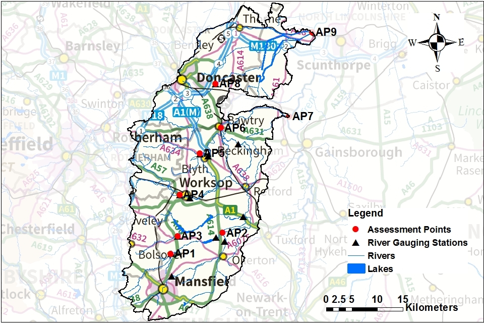
© Environment Agency copyright
The Idle and Torne catchment map shows:
- the catchment’s location with respect to the neighbouring area in East Midlands (EMD)
- network of major rivers
- location of major towns (including Doncaster, Worksop and Mansfield)
- location of assessment points (APs) and gauging stations on the river network
Landscape and land use
Agriculture (particularly arable agriculture) is the dominant land use in the catchment area. Consequently, agriculture is vitally important to the economy of this ALS area. Agriculture relies heavily on local surface and groundwater abstraction, principally for irrigation. The headwaters of the rivers in the catchment are urbanised, particularly around Mansfield and Worksop. However, there are a number of protected areas within the catchment highlighting the diverse nature of the environment.
- population: 605,000 (estimated from ONS 2019 mid-year local authority estimates)
- 747 farms covering 86,726 hectares of farm land (Defra farm statistics)
Land use statistics based upon LCM2019 © NERC (UKCEH) 2020:
| Land Use Type | Proportion of catchment (%) |
|---|---|
| Permanent grassland | 10.9% |
| Arable | 54.8% |
| Urban | 16.5% |
| Forested | 14.4% |
| Other | 3.4% |
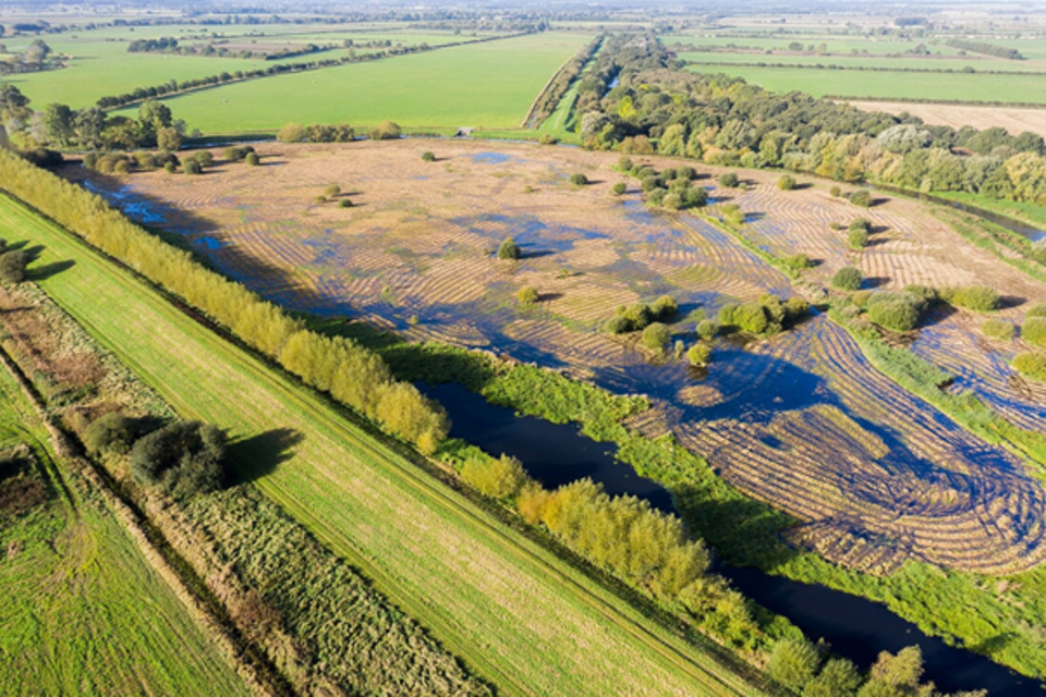
The photograph shows the Idle washlands SSSI (unit 4) in the Idle and Torne ALS area.
Water resources
The Idle drains a catchment area of approximately 879 km2 and the Torne an area of approximately 328 km2.
The River Idle is a significant tributary of the River Trent. The Rivers Maun, Meden and Poulter meet near Gamston, south of Retford to form the River Idle, joined downstream by the River Ryton. At Bawtry, north of Retford, the River Idle turns eastwards to its confluence with the River Trent at the village of West Stockwith, north of Gainsborough.
The River Torne rises near Tickhill and flows north-eastward around the south east of Doncaster, through the heavily drained area of the Isle of Axholme, to its confluence with the River Trent at Keadby. The Chesterfield Canal enters the catchment to the west of Worksop and traverses towards and through Retford before continuing to and entering the River Trent at West Stockwith. The Stainforth and Keadby Canal traverses the catchment but has no hydrological interaction with the Idle and Torne catchment.
There are sources of groundwater (aquifers) across the Idle and Torne catchment. The geology of the Idle and Torne ALS area is dominated by:
- Lower Magnesian Limestone
- Sherwood Sandstone
- Mercia Mudstone
The Magnesian Limestone and Sherwood Sandstone are both classified as principal aquifers, important for strategic water supplies and baseflow to rivers. The area has a rich history of coal mining with extensive measures of coal underlying the Lower Magnesian Limestone and extending eastwards beneath the Sherwood Sandstone at depth. The Sherwood Sandstone has historically been heavily exploited for abstraction. Public water supply in the catchment is primarily sourced from the principal aquifer of the Sherwood Sandstone with multiple borehole sites. However, the catchment also receives imported water from Derbyshire. Three water companies cover the catchment:
- Severn Trent Water are the principle supplier
- Anglian Water’s supply area extends into the east
- Yorkshire Water’s supply area extends into the north
Public water supply and agriculture place the biggest pressure on groundwater resources. Agricultural abstraction dominates surface water with its need for irrigation. This water is predominantly needed in the summer months. Heavy industry accounts for a significant part of abstraction particularly around:
- Mansfield
- Worksop
- Doncaster
However, due to the decline in heavy industry, parts of Doncaster have seen groundwater levels rise.
111 million m3 of water abstracted per year (based on 2013-18 average)
- 464 licensed abstractions
- 136 licences with Hands off Flow (HoF) restrictions at 8 gauging stations
- 75 licences with Hands off Level (HoL) restrictions at 7 gauging stations
- 76.2% of the catchment underlain by principal aquifer
Proportion of different sectors’ abstraction based on licensed abstraction quantity:
| Abstraction licence sector | Proportion of total licensed quantity (%) Surface and groundwater combined | Proportion of total licensed quantity (%), groundwater only |
|---|---|---|
| Public water supply and other potable uses | 69.1% | 84.4% |
| Agriculture | 11.9% | 5.6% |
| Industry | 11.9% | 7.0% |
| Amenity/environmental | 3.9% | 2.9% |
| Power generation | 3.2% | 0.1% |
Climate change
Climate change will impact on the quantity and seasonal availability of water resources within the catchment.
The projected climate change impacts on rainfall and river flow for the Midlands Region by the 2050s are for:
- rainfall to decrease by 34% in the summer but increase by 29% in the winter
- low flows to be 65% lower but peak river flows to be 30% higher
Climate change projections are estimated using data from UKCP09, consistent with a 4ºC rise by 2100. Further details on the assumptions used can be found in the Environment Agency Climate impacts tool.
Further information is provided in section 5.2.
Environment and sustainability
The Idle and Torne catchment encompasses several designated sites. These are highly protected by UK law because of their special fauna and floral environment. The protected areas (shown on Map 9) include:
- 3 Special Areas of Conservation (SAC) - Birklands and Bilhaugh, Thorne Moor and Hatfield Moor
- one Special Protection Area (SPA) - Thorne and Hatfield Moors
- one Site of Special Scientific Interest (SSSI) - the Idle Washlands SSSI
Section 4.5 provides further details on specifications and importance of each site.
The Idle and Torne catchment is closed to further consumptive abstraction due to over-abstraction. Measures have been taken to address the impact of unsustainable abstraction on the catchment. Measures have been taken in 3 water bodies and further work is planned to meet the requirements of the Water Framework Directive (WFD) - see section 5.1.
Our licensing approach ensures that we avoid deterioration within this catchment in line with the WFD. The WFD seeks environmental objectives to protect and enhance the water environment. It ensures the sustainable use of water resources for economic and social development. We assess the impacts of new water abstraction applications to make sure that they comply with the WFD. This includes ensuring water bodies will maintain a healthy ecology. If the ecology is not good, we ensure abstraction will not deteriorate the ecology further. WFD status is assessed at a water body scale. Currently the overall WFD status of the surface water bodies across the catchment are predominently either poor or moderate. Water body WFD status can be:
- bad
- poor
- moderate
- good
- high
Groundwater body status is assessed with a separate set of tests, with the status reported as either good or poor. The limestone and sandstone groundwater bodies across the catchment are at poor status. The less significant mudrock groundwater body remains at good status.
83 designated protected areas (SACs, SPAs, SSSIs, and LNRs)
Licence reductions:
- Restoring Sustainable Abstraction (RSA) programme: 4,745,000 m3/year
- unused and underused licence project: 1,726,264 m3/year
2.2 The priority catchment initiative and partnership working
The Idle and Torne catchment was selected as a priority catchment in the Defra water abstraction plan. Since the autumn of 2018, we have been working with water users and other partners exploring modern ways of managing water. We are working together across sectors including:
- public water supply
- agriculture
- environment
- flood risk management
- navigation
This will deliver multi-functional outcomes which are good for:
- the environment
- people and business
This catchment was selected as a priority catchment for a number of reasons including:
- the catchment is currently closed to new consumptive abstraction licences - due to over-abstraction and concerns over the impact on the ecology
- the catchment has high grade agricultural land - this suffers from flooding in the winter months but restricted water availability in the summer
- there is unmet demand for water and potential for water to be shared amongst abstractors
- there is a history of collaboration between catchment stakeholders and an appetite for innovation
- climate change is projected to reduce rainfall in the summer months, when abstraction is at its highest, but exacerbate heavy rainfall and flooding in the winter
Three catchment partnerships are active in this catchment:
- River Idle
- Sherwood
- Torne
They bring together stakeholders from a range of backgrounds to address issues in the catchment. In addition there are also several water resources themed groups which feed into the Catchment Based Approach (CaBA) partnership.
3. Water resource availability in the Idle and Torne catchment
3.1 Surface water availability
The method for calculating the water resource availability is explained in Managing water abstraction. Water availability is calculated at selected Assessment Points (APs). The maps show the water availability calculated at the AP, local water availability may differ. There are 9 APs in the Idle and Torne ALS:
- AP1, Upper Meden: River Meden and feeding tributaries upstream of Church Warsop gauging station
- AP2, Maun and Meden: River Maun and the River Meden downstream of Church Warsop
- AP3, Upper Poulter: River Poulter upstream of Cuckney, including tributaries
- AP4, Upper Ryton: River Ryton and its tributaries up to the gauging station situated at Worksop
- AP5, Oldcotes Dyke: Oldcotes Dyke from its headwaters to the confluence with the River Ryton at Blyth
- AP6, River Idle (Bawtry Bridge): a large catchment encompassing flows from the Rivers Meden, Maun, Poulter and Ryton
- AP7, River Idle (West Stockwith): River Idle between Bawtry and West Stockwith - the system is heavily influenced by West Stockwith pumping station which regulates when and how water discharges to the River Trent
- AP8, River Torne: River Torne rises to the south of Tickhill from Sandbeck Lake and flows north eastwards to Auckley gauging station
- AP9, Three Rivers (Keadby): level dependent section of the River Torne from Auckley, covering the Isle of Axholme Level Dependant Management Unit (LDMU)
Water resource availability colours and implications for licensing
We use colours to represent different surface water availability at a range of flows:
Water available for licensing
Green
There is more water than required to meet the needs of the environment. New licences can be considered depending on local and downstream impacts.
Restricted water available for licensing
Yellow
Full Licensed flows fall below the Environmental Flow Indicators (EFI).
If all licensed water is abstracted there will not be enough water left for the needs of the environment. No new consumptive licences would be granted. It is likely we’ll be taking action to reduce full licensed risks. Water may be available if you can ‘buy’ (known as licence trading) the entitlement to abstract water from an existing licence holder.
Water not available for licensing
Red
Recent actual flows are below the EFI.
This scenario highlights water bodies where flows are below the indicative flow requirement to help support a healthy ecology in our rivers. We call this ‘Good Ecological Status’ (GES) or ‘Good Ecological Potential’ (GEP) where a water body is heavily modified for reasons other than water resources.
Note: we are currently taking action in water bodies that are not supporting GES or GEP. We will not grant further licences. Water may be available if you can buy (known as licence trading) the amount equivalent to recently abstracted from an existing licence holder.
Heavily Modified Water Bodies (HMWBs) (and/or discharge rich water bodies)
Grey
These water bodies have a modified flow that is influenced by reservoir compensation releases or they have flows that are augmented. These are often known as ‘regulated rivers’. They may be managed through an operating agreement, often held by a water company. The availability of water is dependent on these operating agreements. More detail if applicable can be found in section 4.1 ‘surface water’.
There may be water available for abstraction in discharge rich catchments, you need to contact us to find out more.
The water resource availability is calculated and the colour assigned at 4 different flows:
- Q30 – the flow of a river which is exceeded on average for 30% of the time, therefore you would expect the river flow to be lower than Q30 on 256 days in an average year, i.e. a higher flow
- Q50 – the flow of a river which is exceeded on average for 50% of the time, therefore you would expect the river flow to be lower than Q50 on 183 days in an average year
- Q70 – the flow of a river which is exceeded on average for 70% of the time, therefore you would expect the river flow to be lower than Q70 on 110 days in an average year
- Q95 – the flow of a river which is exceeded on average for 95% of the time, therefore you would expect the river flow to be lower than Q95 on 18 days in an average year, i.e. a low flow
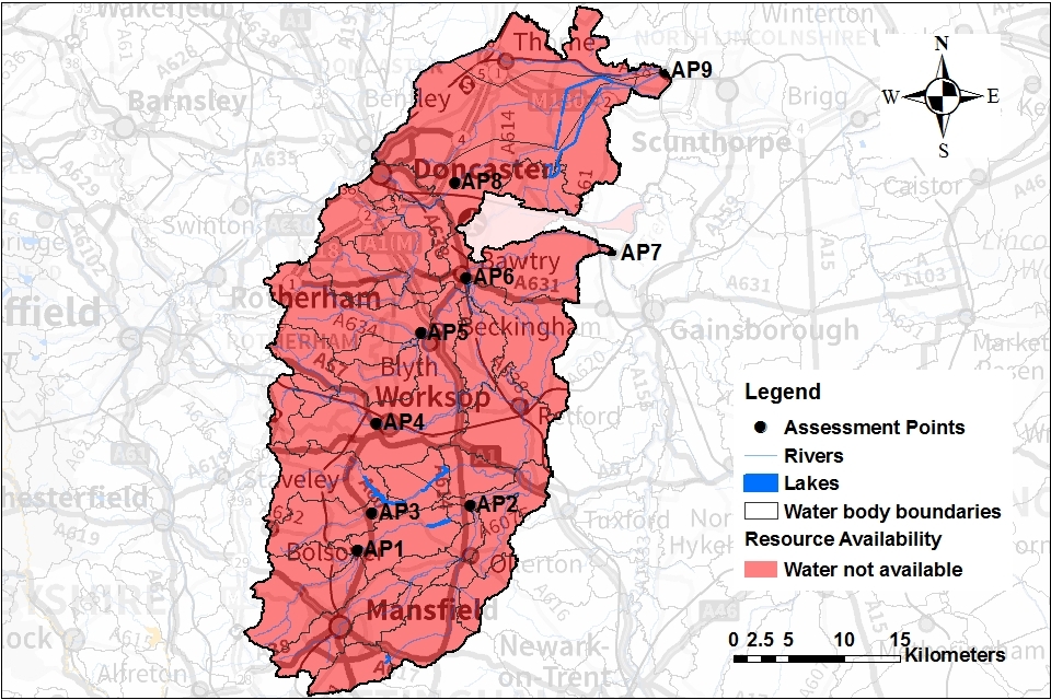
Water availability maps
The water availability colours at Q30/Q50/Q75/Q95 for the Idle and Torne catchment are presented in Maps 2 to 5. All maps are red meaning that there is no water available for further consumptive abstraction licensing at assessed flows. The maps also show:
- the river network
- location of the APs
- boundaries of the water bodies across the catchment
Map 2: Water resource availability colours at Q30 for the Idle and Torne ALS area

© Environment Agency copyright
Map 3: Water resource availability colours at Q50 for the Idle and Torne ALS area

© Environment Agency copyright
Map 4: Water resource availability colours at Q75 for the Idle and Torne ALS area

© Environment Agency copyright
Map 5: Water resource availability colours at Q95 for the Idle and Torne ALS area
© Environment Agency copyright
3.2 Groundwater resource availability
Groundwater availability is guided by the surface water resource availability unless we:
- have better information on principal aquifers
- are aware of local issues we need to protect
For the principal aquifers in the Idle and Torne ALS area, water availability has been assessed using a number of tests. This is combined with monitoring data and numerical modelling. For secondary aquifers, where we typically have less information, groundwater availability is guided by the surface water availability.
In certain areas, resource concerns over groundwater mean that the standard water resource availability colours have been overridden.
Under the WFD, aquifers are designated as named groundwater bodies (GWBs). We may divide GWBs into groundwater management units (GWMUs). In the case of principal aquifers, we use the information and assessments on these units to determine water availability and licence restrictions. Within the Idle and Torne catchment, groundwater has been assessed using both GWBs and GWMUs to represent the water resource status for groundwater.
The Sherwood Sandstone is a principal aquifer of strategic importance. It provides a large part of Nottinghamshire and surrounding areas with drinking water supply. It has a vast outcrop area within the Idle and Torne catchment running in a wide vertical band in the centre of the catchment. The large area of the Sherwood Sandstone has been split into 5 different GWMUs (see Map 6 and Table 2):
- Ravenshead North
- Thoresby
- Retford
- Blyth
- Hatfield
The Magnesian Limestone is another important principal aquifer in this catchment, providing:
- a sustainable source of water to agricultural abstractors
- baseflow to support the headwaters of many of the catchment’s rivers
It is situated immediately to the west and runs parallel to the Sherwood Sandstone. It is represented by 3 GWMUs (see Map 3).
Groundwater resource availability colours and implications for licensing
We use colours to represent different groundwater availability at a range of flows:
Water available for licensing
Green
Groundwater unit balance shows groundwater available for licensing. New licences can be considered depending on impacts on other abstractors and on surface water.
Restricted water available for licensing
Yellow
Groundwater unit balance shows more water is licensed than the amount available. But the actual situation is sustainable because either:
- recent actual abstractions are lower than the amount available
- management options are in place to deal with known local impacts
In restricted groundwater units no new consumptive licences will be granted. We may also investigate the possibilities for reducing fully licensed risks. Water may be available if you can ‘buy’ (known as licence trading) the entitlement to abstract water from an existing licence holder.
In other units there may be restrictions in some areas e.g. in relation to saline intrusion.
Water not available for licensing
Red
Groundwater unit balance shows more water has been abstracted based on recent amounts than the amount available. We will not grant further licences.
Groundwater availability maps
The groundwater availability map shows in this catchment that there is no water available for new consumptive abstraction across all GWMUs.
Map 6: Groundwater resource availability colours for the Idle and Torne ALS area
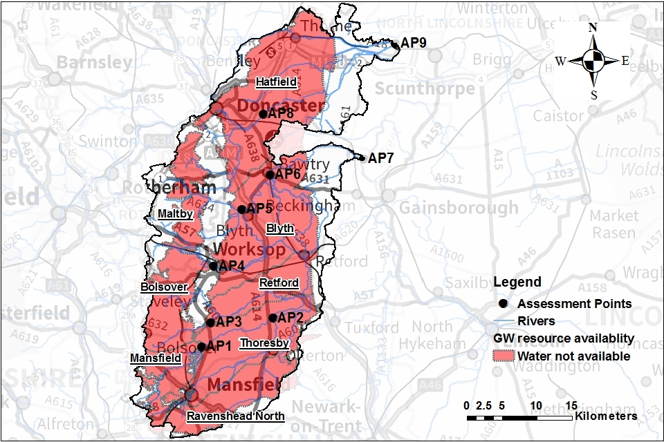
© Environment Agency copyright
All groundwater management units (GWMUs) are red. This meant there is no water available for consumptive abstraction licensing across these units. This map also shows:
- the river network
- location of the APs
- boundaries of the water bodies across the catchment
3.3 Resource reliability
Map 7 gives an indication of the resource availability for consumptive abstraction in the Idle and Torne ALS area expressed as a percentage of time. It can be seen from the map that resource reliability is less than 30% across the whole catchment. However, the Idle and Torne catchment is closed to further consumptive abstraction (see section 4 for our abstraction strategy).
Map 7: Reliability of water resource for consumptive abstraction in the Idle and Torne ALS area expressed as percentage of time available
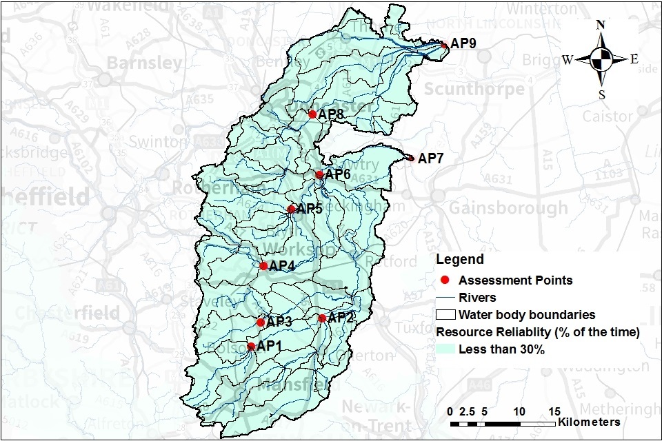
© Environment Agency copyright
This map also shows:
- the river network
- location of the APs
- boundaries of the water bodies across the catchment
3.4 Other considerations for resource availability and reliability
We may have to add constraints to licences such as Hands off Flow (HoF) and Hands off Level (HoL) conditions to protect the:
- environment
- rights of other abstractors
As a result, when we grant a licence, it doesn’t mean that we guarantee a supply of water. These conditions specify that if the flow in the river or groundwater level drops below what’s needed to protect the environment, abstraction must reduce or stop. In dry years, restrictions are likely to apply more often. This will affect the reliability of supply.
There is no guarantee that we will grant a licence, even where water is available for abstraction. This is because we have to determine each application on its own merits. Local factors may mean we’re either unable to grant a licence as applied for, or even at all.
New licences within a catchment are usually given a Common End Date (CED). This allows them to be reviewed at the same time. The next CED for this ALS is 31 March 2038 and the subsequent one is 31 March 2050.
3.5 Impoundments
Applications for impoundments will be dealt with on a case-by-case basis. More information may be found on our water management web pages.
4. How we manage water availability in the Idle and Torne ALS area
4.1 Surface water
We assess surface water flows at Assessment points (APs). These are significant points on a river, often where 2 major rivers join or at a gauging station. APs cover multiple surface water bodies.
Where groundwater abstractions directly impact on surface water flows, we measure the impact at the surface water AP. Some rivers in the Idle catchment rise on bedrock that supplies enough water to satisfy the needs of the environment and existing licensed abstraction. This is also true of the River Torne (AP8). However, there are a number of sub-catchments where there is not sufficient water including upstream of:
- AP2
- AP7
- AP9
This makes these APs critical for licensing. Where there are critical APs downstream, the licensing policy will be determined by the situation at the critical AP. As a result, upstream catchments may be closed to further licensing to protect the downstream critical APs.
Table 1 gives an indication of:
- how much water is available for further abstraction
- the associated restrictions we may have to apply to new and varied abstraction licences from the main river
Depending on the nature of the catchment, tributaries to the main river may be subject to different restrictions and quantities. This may be assessed locally on a case-by-case basis.
Where applicable, each HoF is linked to an AP and is dependent on the resource availability at that AP. In some cases additional restrictions may apply to licences where there is a more critical AP resource availability downstream. This is to protect the ecological requirements of the river and other water users. This is detailed in the last column of Table 1 if applicable.
All abstraction licence applications:
- are subject to an assessment to take account of any local and downstream issues
- may be subject to further restrictions
Reading from top to bottom in Table 1 are the APs in the the Idle and Torne ALS area.
Following decades of groundwater over-abstraction, groundwater levels have receded below the bed of many watercourses that traverse the Sherwood Sandstone outcrop. As a result, rivers have had their baseflow proportion removed. Therefore, these results need to be overridden in order to protect the flows in downstream APs where the results are much more severe. As a consequence, we have decided to continue to keep the whole catchment closed to further consumptive abstraction licensing (Table 1).
Table 1: Summary of licensing approach for the assessment points of Idle and Torne ALS area
| AP | Name | AP National Grid Reference | Water Resource Availability | HOF Restriction (Ml/d) | Number of days per annum abstraction may be available | Approximate volume available at restriction (Ml/d) | Is there a gauging station at this AP? |
|---|---|---|---|---|---|---|---|
| 1 | Upper River Meden - Church | SK5579767989 | No Water Available | N/A | 0 | 0 | Yes |
| 2 | River Maun and Meden - Whitewater | SK6597272069 | No Water Available | N/A | 0 | 0 | Yes |
| 3 | Upper River Poulter - Cuckney | SK5713371410 | No Water Available | N/A | 0 | 0 | Yes |
| 4 | Oldcotes Dyke - Blyth | SK5753079484 | No Water Available | N/A | 0 | 0 | Yes |
| 5 | River Ryton - Worksop | SK6151487621 | No Water Available | N/A | 0 | 0 | Yes |
| 6 | River Idle - Bawtry Bridge | SK6559592600 | No Water Available | N/A | 0 | 0 | No |
| 7 | River Idle - West Stockwith | SE6459301217 | No Water Available | N/A | 0 | 0 | No |
| 8 | River Torne - Auckley | SE8350811296 | No Water Available | N/A | 0 | 0 | Yes |
| 9 | Three Rivers - Keadby | SK4481330013 | No Water Available | N/A | 0 | 0 | No |
4.2 Groundwater
Where groundwater abstractions directly impact on surface water flows, including reduction of base flow, the impact is measured at the surface water AP. In these cases, restrictions may be applied to licences, such as Hands off Level (HoL) conditions. The HoL is a groundwater level below which an abstractor is required to reduce or stop abstraction.
A HoF may be applied when river flows fall below a certain flow in a connected watercourse.
Other restrictions may apply where availability is limited or to protect the environment, for example to prevent saline intrusion.
Licence restrictions on groundwater abstractions in the Idle and Torne ALS area
As mentioned in Section 3.2 there are 8 GWMUs as well as superficial deposits within the boundary of the Idle and Torne catchment.
Table 2 details water availability status for these GWMUs and the superficial deposits. It sets out the restrictions that might be applied to abstractions likely to impact on groundwater-dependent environments. Overall, no water is available for licensing from the groundwater resources. This is to protect river baseflow and dependent environments.
Table 2: Licence restrictions on groundwater abstractions in the Idle and Torne ALS area
| Groundwater body | Groundwater management unit | Water resource availability | Licence restriction |
|---|---|---|---|
| Idle Torne PT Sandstone Nottinghamshire and Doncaster | Ravenshead North | No Water Available | Closed to protect baseflows. See Section 5.3 for water rights trading options |
| Idle Torne PT Sandstone Nottinghamshire and Doncaster | Thoresby | No Water Available | Closed to protect baseflows. See Section 5.3 for water rights trading options |
| Idle Torne PT Sandstone Nottinghamshire and Doncaster | Retford | No Water Available | Closed to protect baseflows. See Section 5.3 for water rights trading options |
| Idle Torne PT Sandstone Nottinghamshire and Doncaster | Blyth | No Water Available | Closed to protect baseflows. See Section 5.3 for water rights trading options |
| Idle Torne PT Sandstone Nottinghamshire and Doncaster | Hatfield | No Water Available (not including the Doncaster Sub-Unit) | Closed to protect baseflows. See Section 5.3 for water rights trading options |
| Idle Torne Magnesian Limestone | Mansfield | No Water Available | Closed to protect baseflows. See Section 5.3 for water rights trading options |
| Idle Torne Magnesian Limestone | Bolsover | No Water Available | Closed to protect baseflows. See Section 5.3 for water rights trading options |
| Idle Torne Magnesian Limestone | Maltby | No Water Available | Closed to protect baseflows. See Section 5.3 for water rights trading options |
| Superficial deposits | N/A | No Water Available | Closed to protect baseflows. See Section 5.3 for water rights trading options |
The Doncaster Sub-Unit is a small area around Doncaster town centre. It covers part of the Sherwood Sandstone Hatfield GWMU and extends into the Don and Rother area. Unlike the Hatfield unit, this area has has been subject to rising groundwater levels because of reductions in industrial abstraction. Within the Doncaster Sub-Unit we will consider applications for new licences up to a maximum licensable resource of 1Ml/d. This figure will be reviewed regularly.
4.3 Level dependent environments
The Idle and Torne ALS area contains level dependent environments (LDE). We have divided the area into level dependent management units (LDMUs). We have completed an assessment on each of these units. Table 3 and Map 8 provide details of the 2 LDMUs (the Idle and the Isle of Axholme) across the catchment and the licensing approach applicable to them.
Table 3: Licence restrictions on abstractions in relation to Level Dependent Environments in Lower Trent and Erewash CAMS area
| Level Dependent Management Unit | Licensing approach |
|---|---|
| Idle | No Water Available |
| Isle of Axholme | No Water Available |
Map 8: Level dependant environments in the Idle and Torne ALS area.

© Environment Agency copyright
The map presents the Idle LDMU in purple and Isle of Axholme LDMU in brown. This map also shows:
- the river network
- location of the APs
- boundaries of the water bodies across the catchment
4.4 Heavily modified water bodies (HMWBs)
A heavily modified water body is an existing body of water that has had its original appearance significantly changed to suit a specific purpose. HMWBs can be classified for many reasons, for example:
- a river water body that has undergone extensive re-alignment for navigation
- a flood defended coastline
For water resources purposes it means that the flow regime has been altered by flow regulation/augmentation.
Within the Idle and Torne ALS area, there are no watercourses that are designated HMWB for water resources reasons. This is mainly due to the fact that there are:
- no public water supply impounding reservoirs within the catchment
- no surface water abstraction for public water supply
There are, however, a number of water bodies that are designated HMWB for reasons other than water resources. These include parts of the Rivers Maun, Idle and Torne. There are also a number of lakes and drain water bodies which are designated artificial. Both the HMWBs and the artificial water bodies are designated for reasons including:
- flood protection
- land drainage
- recreation
- urbanisation
- wider environment
4.5 Protected areas
The Conservation of Habitats and Species Regulations 2017 (Habitats Regulations) provides a very high level of protection to 2 types of designated sites due to their special environment. These are:
- Special Areas of Conservation (SAC), which contribute to biodiversity by maintaining and restoring habitats and species
- Special Protection Area (SPA), which provide protection to birds and their nests, eggs and habitats
As a matter of government policy, Ramsar sites (internationally important wetland sites) are treated in the same way as SACs and SPAs. Ramsars, SACs and SPAs are referred to collectively as European sites. Sites of Special Scientific Interest (SSSI) also carry a high level of environmental importance.
Conservation objectives are the overarching objectives for European and SSSI protected sites to maintain or reach favourable condition. These are set by Natural England. The conservation objectives may consist of qualitative and quantitative descriptions. The process for setting targets that underpin the objectives, is described through JNCC approved ‘Common Standards Monitoring Guidance’ (CSMG). These targets are used by Natural England in assessing the condition of European and SSSI protected sites. These quantitative targets are considered by Natural England as a pre-requisite for achieving the conservation objectives for European or SSSI designated sites.
There are 3 SACs, one SPA and one SSSI across the Idle and Torne catchment.
These are:
Birklands and Bilhaugh SAC
This is a woodland located in the heart of Sherwood Forest.
Thorne Moor SAC
This is only partially within the Idle and Torne catchment. It is located south of Goole and is England’s largest area of lowland raised bog. Although recent management has increased the proportion of active raised bog at Thorne Moors, the sub-component of Goole Moors, where peat-extraction has now ceased, means that the site is still predominantly degraded raised bog. The restored secondary surface is rich in many species associated with active raised bogs.
Hatfield Moor SAC
This is primarily designated as a remnant of the once-extensive bog and fen peatlands within the Humberhead Levels. It is the second-largest area of extant lowland raised bog peat in England. Little, if any, original bog surface has survived the massive extraction of peat over the last few decades. Peat-cutting has now ceased, and the bog is being restored.
Thorne and Hatfield Moors SPA
These is also a designated SPA for the presence of breeding migratory European Nightjars.
The Idle Washlands SSSI
This is made up of 4 distinct units, all below the high tide level of the River Trent. These sites are at:
- Bawtry
- Misson West
- Misson East
- Idle Stop
The washlands are important feeding and roosting sites for populations of wintering waterfowl. The SSSI is seasonally frequented by coarse fish species from the River Idle; in particular Common Carp.
Map 9: Location of protected areas across the Idle and Torne ALS area
There are 3 SACs, one SPA and one SSSI across the Idle and Torne catchment (Map 9).
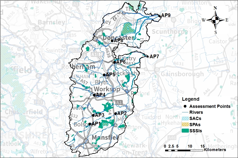
© Environment Agency copyright
Map 9 shows the spread of designated sites and SSSIs across the Idle and Torne ALS area:
- SACs are hatched in cyan
- SPAs are hatched in brown
- SSSIs are presented as green patches across the catchment
This map also shows:
- the river network
- location of the APs
- boundaries of the water bodies across the catchment
For further information regarding SACs and SPAs visit the JNCC website.
4.6 Environmental projects in the Idle and Torne ALS area
Some new abstraction licences may be allowed for environmental gains. This ensures the environment is protected and enhanced. An example is wetland recreation.
These abstractions may be allowed to get a licence within this catchment if:
- the primary benefit is for environmental enhancement or flood risk reduction
- there is no direct commercial gain to the landowner
- there are no adverse impacts on the donor water sources, other licensed abstractors who have protected rights, or other lawful uses of water
These principles are aimed to help clarify the Idle and Torne position on environmental projects and enhancements.
Early discussion is essential with the Catchment Coordinator and our Integrated Environment Planning Team. They will be able to assess your proposals against these principles to decide whether a licence may be granted.
5. Managing the catchment together
5.1 Action on unsustainable abstraction
Managing water abstraction gives details on:
- what is an unsustainable abstraction
- the measures available to resolve environmental issues caused by abstraction
This section provides information about the actions taken or to be taken to tackle the issue of unsustainable abstraction across the Idle and Torne catchment.
Restoring sustainable abstraction (RSA) scheme
The Water Framework Directive (WFD) requires that measures are taken to protect and improve the hydrological regime of water bodies. In the period 2010-2015, Severn Trent Water undertook WFD investigations into the impact of groundwater abstraction for public water supply from specific licences. Investigations focussed on abstraction impacts in the Idle catchment on flows in:
- Rainworth Water
- Ranskill Brook
As a result of these investigations, Severn Trent Water revoked 3 unused public water supply licences in the upper Rainworth Water water body and one in the Ranskill Brook water body. This will ensure that these licences could not cause deterioration of flows in these water bodies in the future.
In the period 2015-2020 Severn Trent Water also undertook investigations under the WFD. They looked into the impact that groundwater abstraction for public water supply from their licences was having on:
- flows in the lower Rainworth Water water body
- flows in the Bevecotes Beck
- flows in the River Maun
- flows in the River Poulter
- flows in the Vicar Water
- waterbodies across the Sherwood sandstone aquifer in Nottinghamshire
The results of these investigations will mean that Severn Trent Water will reduce abstraction at some of their boreholes abstracting from the Sherwood Sandstone. This will include boreholes in both the Lower Trent and Erewash and Idle and Torne catchments. In total this reduction will mean that Severn Trent Water abstraction from the Sherwood sandstone will reduce by 23.5 Ml/d below recent actual abstraction rates. The reductions in licences will come into effect by 2030. In the period 2020-2025, Severn Trent Water will also implement environmental measures in the water bodies:
- Vicar Water
- Bevecotes Beck
- Rainworth Water
These will reduce the ecological susceptibility to low flows by improving habitat and/or water quality within the waterbodies.
In the period 2015-2020 Anglian Water also undertook investigations under the WFD. They investigated the impact that groundwater abstraction from their licences for public water supply was having on flows in the:
- River Poulter
- River Idle
As a result of these investigations, Anglian Water will reduce abstraction from their licence near the River Poulter. This reduction will mean that Anglian Water’s licence will reduce by 6 Ml/d below recent actual abstraction rates. The reduction in the licence will come into effect by 2025.
The Water Framework Directive also requires that there is no deterioration of the environment. Therefore in the period 2020-2025 Severn Trent Water and Anglian Water will reduce their licensed abstraction from the Sherwood Sandstone. This is part of the Water Industry National Environment Plan (WINEP). In the Idle and Torne, all Severn Trent sources listed in the WINEP with a ‘sustainability change’ measure type will be reduced down to recent actual abstraction quantities. For Severn Trent Water, the reductions in the licences will be made by 2025 but the new conditions will take effect in 2030. Anglian Water will also reduce their licensed abstraction from the Sherwood Sandstone to ensure that there is no deterioration of the environment.
In this period, Yorkshire Water will carry out investigations into water balance and potential impact on resources from likely future increases in the abstraction regime. If detrimental impacts are identified, Yorkshire Water will undertake options appraisal to identify measures to mitigate the risks. They will need to balance this with the Company’s and Environment Agency’s duties to maintain public water supplies.
Renewal of time limited licences
Renewal of time limited licences will be considered subject to the following criteria and local considerations in addition to HoF and/or HoL conditions (where applicable):
- environmental sustainability is not in question
- there is a continued justification of need for the water
- the water is used efficiently
Our sustainability test includes considering the risk of environmental deterioration.
We have been considering the criteria for the renewal of the Sherwood Sandstone time limited abstraction licences in 2024. To grant a renewal of abstraction we will need to ensure that there is no deterioration of the environment. We will also ensure that the:
- ecological habitats provided by the rivers and wetlands do not deteriorate as a result of continued abstraction
- Sherwood Sandstone aquifer is protected
Under used licences project
The Environment Agency’s unused licences programme is addressing the large amount of water licensed within abstraction licences that is not abstracted each year. This limits water availability for those that need it and, in some cases, presents a significant environmental risk if abstraction were to be restarted. The majority of changes to licensed quantities are made voluntarily. However, where there is risk of environmental damage, the Environment Agency can propose the revocation of unused licences using existing legal powers under section 52 of the Water Resources Act 1991.
During the 2 phases of this programme so far, we have contacted almost 180 abstractors in the Idle and Torne ALS area. We contacted abstractors who had not used any of their full licensed quantities in the last:
- 10 years (phase one)
- 4 years (phase 2)
They were asked to revoke their licence if it was no longer required or to confirm why they wished to keep it. The sum of the licensed water reduced or revoked so far is 1,726,264 m3/yr. This is equivalent to approximately 700 Olympic size swimming pools.
Phase 3 will begin shortly. We will be contacting those licence holders from the earlier phases whose licences are still unused and again asking whether they need to keep their licence.
New Authorisations
Historically, taking water from the environment for certain uses and from certain sources could be done without an abstraction licence. We called these ‘exempt activities’. These abstractions exempt from licensing control could potentially take unlimited amounts of water:
- irrespective of availability
- without regard to impacts on the environment or other abstractors
New regulations came into force in January 2018 removing the exemptions for many of these activities. Around 40 applications for abstraction in the Idle and Torne were received, particularly from the agriculture and quarrying sectors. There is a presumption the Environment Agency will grant a licence for an existing previously exempt abstraction to the same extent. This in itself does not change the environmental impact or increase any damage. However, those cases constituting serious damage or previously exempt abstractions with the potential to adversely affect a Habitats Directive site or species may be subject to curtailment or refusal.
Once the New Authorisations are brought into regulation, these will be regularly reviewed at the licences common end date (CED). The New Authorisations, similar to all the other time limited licences, will be subject to the necessary sustainability review. As a consequence, some may have further future restrictions or sustainability revisions imposed.
5.2 Approaches to sustainable water management
Through catchment based working we have undertaken a range of initiatives. This section outlines options initiated in this catchment for future approaches to water management. This includes collaboration and sharing which may be of interest to both new and existing abstractors.
Outputs from ongoing projects will be added to the Idle Catchment partnership website when available.
High flow study
The study aimed to improve understanding of high flows in the catchment. It investigated whether extra high flow abstraction could result in negative ecological impact. High flows are important for managing levels in the Idle Washlands SSSI. Spate flows also wash out fines and stop the sedimentation of gravel river beds.
The study had 2 phases, which built on the original phase one study:
- phase 2a - focused on identifying the sensitive reaches within the catchment
- phase 2b - involved modelling representative, sensitive reaches
The initial findings concluded:
- we need more evidence before opening up the catchment to further abstraction
- the Torne catchment seems less sensitive to further abstraction compared to the Idle
- the Idle catchment is more sensitive to changes in water levels - due to the SSSIs and natural features
- more targeted visits and modelling of the Idle would provide evidence of what the impacts may be
Without further evidence we are not in a position to change the ALS to allow high flow abstraction. However, this phase 2 study provides a good baseline. We are open to further investigations and trials with external partners. The Environment Agency will continue to seek more funding to gather the evidence. Contact us to discuss potential high flow abstraction projects and evidence needs.
Case study: Groundwater recharge and working with natural processes
Some natural processes help to store water in the ground and slow down the rate at which it enters river systems. Evidence shows that taking action to restore natural processes can help make some catchments more resilient to flood events. We have investigated the benefits of working with natural processes to improve resilience to drought. The project focused on the:
- River Poulter
- River Meden
- River Maun
It has produced maps showing where these actions are most likely to be effective in supporting groundwater recharge. Actions which can be taken include:
- improving soil management to reduce compaction issues
- creation of water meadows in valley floors and renaturalising channels
- modifying the structure of the forest to change the water budget
- partially blocking ‘dry’ valleys to enhance infiltration recharge during significant rainfall events
The findings of this project have been shared with stakeholders. They plan to look into trialling some of these methods within the Sherwood catchment. If you would like to trial any methods then contact us to discuss. Further information is available on the Priority Catchment webpage. The full report will be shared on the Idle Catchment partnership website when available.
Water for farmers and wildlife
We are working in partnership with the Royal Society for the Protection of Birds (RSPB). The project aims to explore sustainable land management techniques. It will deliver benefits to the environment, farming and flood risk management, including:
- improved soils
- higher yields
- reduced fertiliser and pesticides
- potential irrigation resources
- improved habitats for wildlife
Further farmer engagement events are planned. To find out more about the trials in this catchment, contact the Environment Agency and ask for the Humber Strategy team.
Agricultural water resources advice visits
The Environment Agency and Natural England’s Catchment Sensitive Farming (CSF) officers have trialled new water resources advice visits at 11 farms in the Idle and Torne. Agricultural abstraction is important within the catchment and we want to strive to ensure:
- the catchment is resilient to climate change
- support the farmers to optimise water use
These visits:
- aim to collate best practice
- provide advice to farmers on improving their water efficiency and management of water
The best practice outputs from these visits will be shared with partners. They will then disseminate with agricultural abstractors.
If the visits are a success, and farmers find the information useful, then water resources can be added to future CSF visits.
Water resources communication and engagement work
Nottinghamshire Wildlife Trust have established a project to highlight water resources locally. This is supported by funding from the Rivers Trust. The project engages with different groups, including schools and the agricultural sector:
- engagement sessions in schools - use of resources pupils can take home to improve water usage
- youth centre sessions focusing on designing and installing a rain garden planter
- working with a farmer to develop and expand a demonstration farm
Further farmer engagement events are planned once COVID 19 restrictions have been lifted.
Climate change scenarios
Climate change projections for this region indicate that summer low flows could be less than half current low flows by 2050. We may experience an increase in droughts and water restrictions. Higher winter rainfall will likely result in increased size and magnitude of flood flows. This may lead to more severe flooding and loss of agricultural land. There is a need to assess how these changes will impact the catchment and how we can adapt.
A Leeds University project is focussing on the impacts of climate change on the River Idle. It will look at the local impact on river flows and water availability. The project provides an opportunity to better understand potential impacts to abstractors. It will also consider how we can improve management of water resources in the future. Work is focusing on developing a catchment scale impact model.
We plan to share the findings through interviews with stakeholders. These will explore climate change impacts on water resources. Further modelling work will consider future options for abstraction in the Idle. Details on the project can be found on the project overview webpage hosted by Leeds University.
Future of priority catchment work
A key success of the priority catchment has been collaboration of the catchment group. This was the first time different sectors discussed water resources at a catchment scale. They considered a variety of concerns including:
- drought
- flood risk
- environmental improvements
All stakeholders had different agendas. But all came together to help improve how water resources are managed and used.
Future management of water resources in this catchment will focus on stakeholders working together to take initiatives forward. During the priority catchments project, we have started to investigate opportunities and innovative ideas. Project outputs will be added to the Idle Catchment partnership website for people to view when available. We are keen to continue to investigate innovative ideas that will improve water resources and the environment. Much of this good work and collaborations are continuing within the catchment. Catchment partnerships are a great place to help improve the environment collectively.
If you would like to join one or be part of the catchment group please email info@nottswt.co.uk. For the Torne catchment contact tornecatchmentpartnership@gmail.com.
5.3 Water rights trading
We want to make it easier to trade water rights. A water rights trade is where a person sells all or part of their water right, as defined by their abstraction licence(s), to another person on a permanent or temporary basis. In the majority of cases a trade will involve a change in abstraction location and/or use which we will need to approve through the issue or variation of abstraction licences.
In licensing trades, as with new abstraction licences, we need to make sure that we don’t cause any deterioration in water body status. This is both:
- within the water body / bodies where the trade will take place
- to downstream water bodies
This section provides a guide to the potential for trading in water bodies of a particular ALS water resource availability colour, as shown on Maps 2 to 5.
To find out more about licence trading, use our guidance on trading water abstraction rights.
We are currently developing new initiatives to support trading in the Idle and Torne catchment.
Help for trading water rights map. This helps abstractors to identify potential trades by providing information on:
- nearby licences
- an indication of the potential for a trade
Temporary seasonal trades trial - is designed to help abstractors trade water over a single irrigation season. Abstractors apply for these trades during a defined ‘trading window’ during the spring. This is following publication of the initial irrigation prospects report.
Guide to the potential trading in water bodies of the Idle and Torne ALS water resource availability colour
Water not available for licensing
Red
We will only trade recent actual abstraction but no increase in recent actual abstraction is permitted in water body. Licensed abstraction will be recovered for the environment.
6. Related links
-
Agriculture and Horticulture Development Board (AHDB) website - provides information on effective use of water on livestock farms
-
Catchment Based Approach community website - provides further information on the catchment based approach
-
UK Centre for Ecology and Hydrology Drought Portal - is an interactive portal presenting information on the laterst hydrological situation across the UK
-
Environment Agency, how to apply for a water abstraction or impoundment licence web pages - provide all the information needed to go through the application process to get a licence
-
Environment Agency manage your water abstraction or impoundment licence online web service - allows abstractors to view and share licence information and submit abstraction returns
-
Environment Agency priority catchments website - provides further information about the priority catchment work
-
The Environment Agency National Framework for Water Resources -explores England’s long-term water needs and the importance of planning at the regional scale and link to the catchment scale
-
Linking Environment and Farming (LEAF) Simply Sustainable Water guide - explains 6 simple steps for managing water quality and use on your land
-
National Farmer’s Union web pages on Irrigation and water resources - provide useful information
-
Natural England’s website - provides further information on protected sites and species
-
Environment Agency and Cranfield University’s guide to planning, designing, constructing and commissioning a water storage reservoir - if you are considering an irrigation reservoir
-
The UK Irrigation Association and Cranfield University - provide a range of irrigation booklets that tackle key issues
-
Waste and Resources Action Programme website has guidance on water efficiency in the food and drink industry
-
Waste and Resources Action Programme website has a guide to water saving devices and practices
7. Glossary
Abstraction - removal of water from a source of supply (surface or groundwater).
Abstraction licence - the authorisation granted by the Environment Agency to allow the removal of water.
Assessment point - a significant point on a river, often where two major rivers join or at a gauging station.
Catchment - the area from which precipitation and groundwater will collect and contribute to the flow of a specific river.
Catchment based approach - partnership working at the river catchment scale to deliver a range of environmental, social and economic benefits while protecting our precious water environments for the benefit of all.
Consumptive abstraction - abstraction where a significant proportion of the water is not returned either directly or indirectly to the source of supply after use. For example for the use of spray irrigation.
Discharge - the release of substances (for example, water, treated sewage effluent) into surface waters.
Environmental flow indicator - flow indicator to prevent environmental deterioration of rivers, set in line with new UK standards set by UKTAG.
Groundwater - water that is contained in underground rocks.
Hands off flow - a condition attached to an abstraction licence which states that if flow (in the river) falls below the level specified on the licence, the abstractor will be required to reduce or stop the abstraction.
Impoundment - a structure that obstructs or impedes the flow of inland water, such as a dam, weir or other constructed works.
Surface water - this is a general term used to describe all water features such as rivers, streams, springs, ponds and lakes.
Water body - units of either surface water or groundwater which we use to assess water availability.
8. Copyright - maps
© Environment Agency copyright and/or database right 2020. All rights reserved. This map includes data supplied under licence from: © Crown Copyright and database right 2020. All rights reserved. Ordnance Survey licence number 100024198.
9. Contact details for further information
For local water resources advice contact the East Midlands Integrated Environmental Planning Team. You can either call or email the team:
- call 03708 506 506 (calls cost no more than a national rate call to an 01 or 02 number)
- email enquiries@environment-agency.gov.uk