East Suffolk abstraction licensing strategy (ALS)
Published 21 December 2020
Applies to England

© Crown copyright 2020
This publication is licensed under the terms of the Open Government Licence v3.0 except where otherwise stated. To view this licence, visit nationalarchives.gov.uk/doc/open-government-licence/version/3 or write to the Information Policy Team, The National Archives, Kew, London TW9 4DU, or email: psi@nationalarchives.gov.uk.
Where we have identified any third party copyright information you will need to obtain permission from the copyright holders concerned.
This publication is available at https://www.gov.uk/government/publications/east-suffolk-abstraction-licensing-strategy/east-suffolk-abstraction-licensing-strategy-als
1. About the licensing strategy
1.1 Overview
This strategy sets out how we manage new and existing abstraction and impoundment within the East Suffolk catchment in the Anglian river basin district.
It ensures that we:
- meet River Basin Management Plan (RBMP) objectives for water resources activities
- avoid deterioration within this catchment
We apply this approach to the water body in which the abstraction is located.
It also applies to:
- all downstream surface water bodies that may be affected by any reduction in abstraction related flow
- adjacent groundwater bodies affected by any reduction in groundwater level
The strategy also sets out local approaches to the sustainable management of water resources. This is in collaboration with partners.
Managing water abstraction describes the technical explanation, legal and policy requirements behind our Abstraction Licensing Strategies (ALS).
The abstraction pages advise on:
- who needs an abstraction or impoundment licence
- how to apply for a licence
1.2 How is the licensing strategy set out?
This ALS provides an overview of how water is sustainably managed in the East Suffolk catchment to:
- provide water for abstraction
- protect the environment
The following is a summary of what each section covers:
Catchment background - sets out additional information about the catchment and the influences and pressures on water availability
Water resource availability - explains how much water is available for abstraction in the catchment.
How we manage water resource availability - explains the local licensing approach for the catchment which is summarised in Table 2. This includes the potential water available for licensing and the restrictions that would be required.
Managing the catchment together - details the actions we are taking where abstraction is currently unsustainable in the catchment. Approaches to ensure sustainable water management in the future are outlined, including information on licence trading.
Related links - are listed for further information on water resource management.
Glossary - explains technical terms included throughout the document
Contact details - on how to get in touch.
Note: whilst our assessment tools are continuously updated, we aim to update this document on a 3-year basis. Therefore some details within this document, for example Hands off Flow (HoF) values, may become outdated. Use this document as a guide to water availability. For up to date and detailed advice see the section contact details.
1.3 Collaborative and sustainable water management
Our long term goal is to develop a stronger catchment focus for water resources management. We are working with abstractors and catchment groups to:
- develop local solutions to existing pressures
- prepare for the future
Catchment groups may include a variety of different partnership groups such as:
- abstractor groups
- local catchment partnerships
- water resource focussed priority catchment groups
- environmental groups
Since the autumn of 2018, we have been collaborating with local partners. In several priority catchments across England we have explored:
- modern and innovative ways of improving access to water
- alternative ways to achieving sustainable abstraction
The East Suffolk catchment was selected as a priority catchment in the Defra water abstraction plan. This plan sets out how the government will reform the way we manage water abstraction to:
- protect the environment
- improve access to water
We assessed water resource availability using our standard approach. We then worked with partners to:
- identify local opportunities to modernise abstraction management
- share resources sustainably both now and in the future
Background information on the priority catchment project is available in the catchment background section. Further details and links on approaches trialled in the East Suffolk catchment are provided in section managing the catchment together.
This strategy is a tool to make informed decisions on the choices abstractors make about their use of water. We want this strategy to help abstractors:
- plan their water use and become more resilient in the face of climate change
- explore the opportunities offered by the priority catchments
2. Catchment background
2.1 Catchment overview
The East Suffolk catchment lies on the east coast of England next to to the North Sea. Stowmarket is in the west of the catchment and Lowestoft and Felixstowe are in the east. The catchment is low-lying and dominated by agriculture. Urban areas account for only 10% of land coverage. The soils close to the coast are light and free draining. This is ideal for growing root vegetable crops. The soils become heavier inland and cereals become the predominant crop. Shingle beaches, salt marshes and estuaries characterise the coastline. This is home to many rare or unique species.
Landscape and land use
The catchment covers an area of 1,364 km2. There is low rainfall and a large agricultural sector.
- population: 430,000 (estimated from ONS 2019 mid-year local authority estimates)
- 1,152 farms covering 119,766 hectares of farm land (Defra farm statistics)
Land use statistics based upon LCM2019 © NERC (UKCEH) 2020:
| Land Use Type | Proportion of catchment (%) |
|---|---|
| Permanent grassland | 18% |
| Arable | 56% |
| Urban | 10% |
| Forested | 10% |
| Other | 6% |
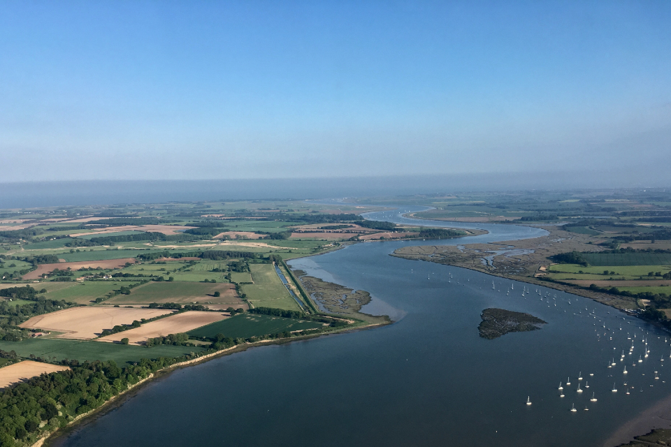
The photograph shows an aerial view of the tidal River Deben looking towards the coast. There are agricultural fields on both banks. The photograph also shows areas of saltmarsh on the banks of the estuary. Photograph courtesy of Simon Barlow, Environment Agency.
Water Resources
The East Suffolk catchment includes the rivers:
- Lothingland
- Wang
- Blyth
- Yox
- Fromus
- Alde
- Ore
- Deben
- Lark and Fynn
- Gipping
- Belstead Brook
There are 4 significant estuaries:
- Alde-Ore
- Butley
- Deben
- Orwell
The estuaries are species-rich habitats and are nationally important areas for over-wintering birds.
There are 2 Water Framework Directive (WFD) groundwater bodies:
- East Suffolk Chalk and Crag
- Felixstowe Peninsula Chalk and Crag
The East Suffolk Chalk and Crag is the more significant of these water bodies. There are very few groundwater abstractions from the Felixstowe Peninsula Chalk and Crag.
The soil next to the coast is light and free-draining. It is ideal for growing vegetables. Vegetable crops need extensive irrigation, driving a high demand for water from agriculture. A quarter of water licensed for abstraction is for agricultural purposes; 90% of this is for spray irrigation.
Potable water accounts for over half the volume of water licensed in the catchment. Anglian Water Services and Essex & Suffolk Water provide potable water within the catchment.
The industrial sector is also a significant abstractor in the catchment.
43.5 million m3
of water abstracted per year (based on 2013-18 average)
- 353 licensed abstractions
- 60 licences with HoF restrictions
- 73% of the catchment underlain by principal aquifer
Proportion of different sectors based on licensed abstraction quantity
| Abstraction licence sector | Proportion of total licensed quantity (%) |
|---|---|
| Public water supply and other potable uses | 57% |
| Agriculture | 25% |
| Industry | 17% |
| Amenity/environmental | 1% |
Climate change
Climate change will impact on the quantity and seasonal availability of water resources within the catchment.
The projected climate change impacts on rainfall and river flow for the East Anglian region by the 2050s are for:
- rainfall to decrease by 39% in the summer but increase by 35% in the winter
- low flows to be 81% lower but peak river flows to be 35% higher
Climate change projections are estimated using data from UKCP09, consistent with a 4ºC rise by 2100. The Environment Agency Climate impacts tool provides further details on the assumptions used.
Environment and sustainability
There are many sites of high conservation importance in the catchment. Many are along the coast and estuaries. These areas are home to important and often rare habitats and species. Many of these sites are water dependent. We must not permit abstraction that will have a negative impact on these natural features. More information on protected sites is available in section 4.3.
We must also ensure that abstraction does not impact on the ecology of rivers and streams. Most of East Suffolk’s water bodies are not achieving good ecological status under the Water Framework Directive (WFD). Flows are being reduced by abstraction to levels that may not support species and habitat in almost 40% of our water bodies. This is contributing to the WFD failures. Section 5.1 explains the actions we are taking to reduce unsustainable abstraction.
97 designated protected areas (SACs, SPAs, SSSIs, LNRs and Ramsar)
Licence reductions:
- Restoring Sustainable Abstraction (RSA) programme: 89,973m3/year
- unused and underused licence project: 387,391m3/year
Water Framework Directive:
- 43 water bodies
- 16% water bodies at good status or higher
- 40% water bodies where flow pressure does not support good status
2.2 The priority catchment initiative and partnership working
The East Suffolk catchment was chosen as a priority catchment in the Defra water abstraction plan.
Since the autumn of 2018, we have been working with water users and other partners exploring modern ways of managing water. We are working together across sectors including:
- public water supply
- agriculture
- environment
- flood risk management
This delivers multi-functional outcomes which are good for:
- the environment
- people and business
Our focus was to bring together all water users. Together they:
- identified the challenges and pressures
- investigated how to improve the water situation
This catchment was chosen for a number of reasons including:
- current levels of abstraction are unsustainable
- there is unmet demand for water due to low rainfall and a large agricultural sector
- there is potential to share water amongst abstractors
- there is a history of collaboration and innovation in the catchment
The priority catchment began with a large stakeholder event in the autumn of 2018. The aim was to gather information on the key water issues that stakeholders wanted to address. We created the East Suffolk Priority Catchment Working Group in March 2019. This group facilitated trials looking at addressing these key issues. The membership includes:
- Anglian Water
- Essex & Suffolk Water
- Essex and Suffolk Rivers Trust
- East Suffolk Catchment Partnership
- East Suffolk Water Abstractor Group
- Suffolk County Council (chair)
- East Suffolk Internal Drainage Board
- Felixstowe Hydrocycle
Together we have developed and initiated many trials. These trials investigate new ways to improve access to water in a sustainable way. There are more details on the priority catchment successes in section 5.2. The working group are continuing to explore ways to address water issues. They are keen to engage with all water users. If you would like to get involved contact the Integrated Environment Planning team.
The East Suffolk Catchment Partnership brings together stakeholders from a range of backgrounds. This partnership addresses environmental issues, including water resources. Essex and Suffolk Rivers Trust host the partnership. For more information visit the East Suffolk Catchment Partnership website.
Water Resources East is a regional group who:
- focus on developing collaborative approaches to water resources management and planning
- engage with stakeholders to find solutions to water scarcity within East Suffolk and the wider region
For more information visit the Water Resources East website.
3. Water resource availability in the East Suffolk catchment
3.1 Surface water availability
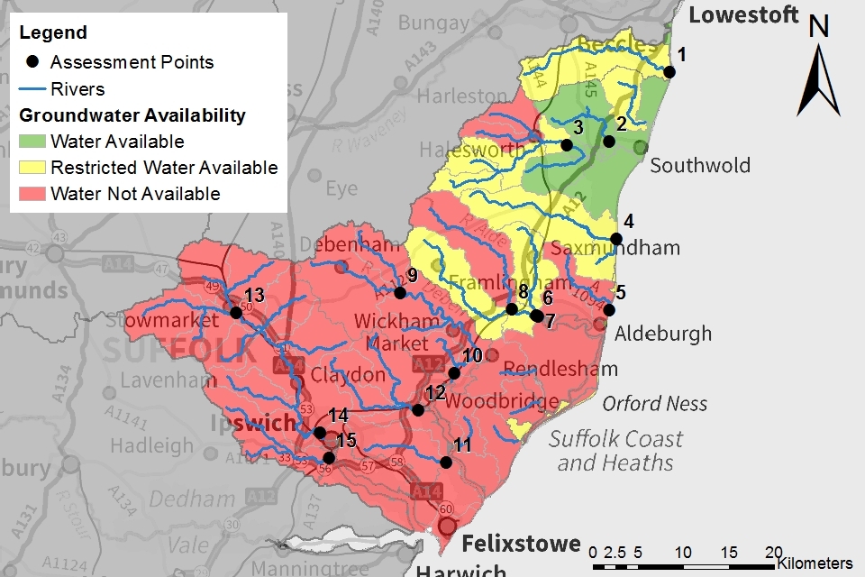
The method for calculating the water resource availability is explained in Managing water abstraction. Water availability is calculated at selected Assessment Points (APs).The maps show the water availability calculated at the AP, local water availability may differ. There are 15 APs in the East Suffolk ALS:
- AP1: covers the Lothingland Hundred River
- AP2: covers the River Wang to Wangford Gauging Station
- AP3: covers the River Blyth from upstream of Halesworth to the Blyford Bridge and Chediston Watercourse
- AP4: covers the River Yox, Minsmere Old River and Leiston Beck
- AP5: covers the Hundred River
- AP6: covers the River Fromus upstream of the confluence with the River Alde
- AP7: covers the River Alde from its confluence with the River Ore to the tidal limit
- AP8: covers the River Ore to its confluence with the River Alde
- AP9: covers the Earl Soham Watercourse and the River Deben upstream of Brandeston Bridge
- AP10: covers the River Deben from Brandeston Bridge to the tidal limit north of Woodbridge, including Potsford Brook and Byng Brook
- AP11: covers Mill River
- AP12: covers the Rivers Fynn and Lark
- AP13: covers the River Gipping until downstream of Stowmarket, Haughley Watercourse, Rattlesden River and Great Finborough Watercourse
- AP14: covers the River Gipping downstream of Stowmarket until it reaches the River Orwell, including the Jordan, Somersham, Coddenham and Wattisham Watercourses
- AP15: covers Belstead Brook
Water resource availability colours and implications for licensing
We use colours to represent different surface water availability at a range of flows:
Water available for licensing
Green
There is more water than required to meet the needs of the environment. New licences can be considered depending on local and downstream impacts.
Restricted water available for licensing
Yellow
Full Licensed flows fall below the Environmental Flow Indicators (EFI) or they are slightly above the EFI. But there is no more water available for licensing at these flows.
Where full licensed flows fall below the EFI, if all licensed water is abstracted there will not be enough water left for the needs of the environment. In some catchments, full licensed flows are slightly above the EFI. This means the needs of the environment are supported, but there is no surplus left for new abstractions. No new consumptive licences would be granted. It is likely we’ll be taking action to reduce full licensed risks. Water may be available if you can ‘buy’ (known as licence trading) the entitlement to abstract water from an existing licence holder. More details on water rights trading are available in section 5.3.
Water not available for licensing
Red
Recent actual flows are below the EFI.
This scenario highlights water bodies where flows are below the indicative flow requirement to help support a healthy ecology in our rivers. We call this ‘Good Ecological Status’ (GES) or ‘Good Ecological Potential’ (GEP) where a water body is heavily modified for reasons other than water resources.
Note: we are currently taking action in water bodies that are not supporting GES or GEP. We will not grant further licences. Water may be available if you can buy (known as licence trading) the amount equivalent to recently abstracted from an existing licence holder. More details on water rights trading are available in section 5.3.
The water resource availability is calculated and the colour assigned at 4 different flow percentiles:
- Q30 – the flow of a river which is exceeded on average for 30% of the time, therefore you would expect the river flow to be lower than Q30 on 256 days in an average year, that is, a higher flow
- Q50 – the flow of a river which is exceeded on average 50% of the time, therefore you would expect the river flow to be lower than Q50 on 183 days in an average year
- Q70 – the flow of a river which is exceeded on average for 70% of the time, therefore you would expect the river flow to be lower than Q70 on 110 days in an average year
- Q95 – the flow of a river which is exceeded on average for 95% of the time, therefore you would expect the river flow to be lower than Q95 on 18 days in an average year, that is, a low flow
Water availability maps
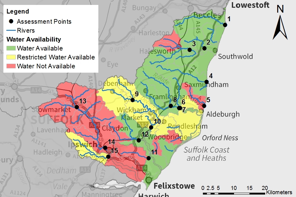
The surface water availability colours for the East Suffolk catchment are presented in Maps 1 to 4.
Table 1: Summary of Maps 1 to 4 – water availability at each assessment point by flow category
Note: water availability status given in this table is at AP level, water availability may be different at a local level.
| Name | Q30 | Q50 | Q70 | Q95 | |
|---|---|---|---|---|---|
| AP1 | Lothingland Hundred | Available | Available | Available | Restricted |
| AP2 | River Wang Wangford GS | Available | Available | Available | Restricted |
| AP3 | River Blyth Blyford Bridge | Available | Available | Available | Restricted |
| AP4 | River Yox - Tidal Limit | Available | Available | Available | Restricted |
| AP5 | Hundred River - Sluice below Thorpeness | Available | Not available | Not available | Not available |
| AP6 | River Fromus Upstream of confl with Alde | Available | Available | Restricted | Restricted |
| AP7 | River Alde at Tidal Limit | Available | Available | Restricted | Restricted |
| AP8 | River Ore Beversham GS | Available | Restricted | Restricted | Restricted |
| AP9 | River Deben Cretingham GS | Available | Restricted | Not available | Not available |
| AP10 | River Deben | Available | Restricted | Not available | Not available |
| AP11 | Mill River Kirton Sluice | Not available | Not available | Not available | Not available |
| AP12 | River Fynn / Lark - Martlesham Sluice | Available | Available | Not available | Not available |
| AP13 | River Gipping Stowmarket GS | Restricted | Not available | Not available | Not available |
| AP14 | River Gipping Horseshoe GS | Restricted | Not available | Not available | Not available |
| AP15 | Belstead Brook | Available | Restricted | Not available | Not available |
These maps give a snapshot of water availability at the 4 flow percentiles. Water may be available at flows percentiles between those shown here. For example, at AP1 surface water is available at flows above Q91. This catchment will appear yellow for Q95 flows in Map 4 and green for Q70 flows in Map 3. Table 2 includes details on surface water resource availability for each assessment point.
Whilst Maps 1 to 4 may show that water is available at a catchment level this may not be the case locally. We assess all proposals on a case-by-case basis. We take into account:
- local flows in the watercourse
- the impact the proposed abstraction might have on designated sites and other abstractors
When considering applying for a new surface water abstraction applicants should be aware:
- we will not accept applications for consumptive summer abstractions in any catchment except during higher flows
- we may consider the extension of the abstraction period of a winter licence into early spring - this may affect the subsistence charges associated with a licence
- a minimum Q95 HoF condition will apply to all new surface water abstractions
- the HoF required to protect surface water flows may be higher than indicated in Maps 1 to 4 and Table 2 based on the local assessment of the proposal
Section 5.1 explains how we will manage surface water licence variations and renewals.
Map 1: surface water resource availability colours at Q30 for East Suffolk ALS
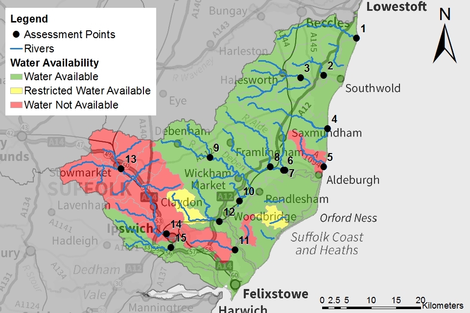
© Environment Agency copyright
Map 2: surface water resource availability colours at Q50 for East Suffolk ALS
© Environment Agency copyright
Map 3: surface water resource availability colours at Q70 for East Suffolk ALS

© Environment Agency copyright
Map 4: surface water resource availability colours at Q95 for East Suffolk ALS
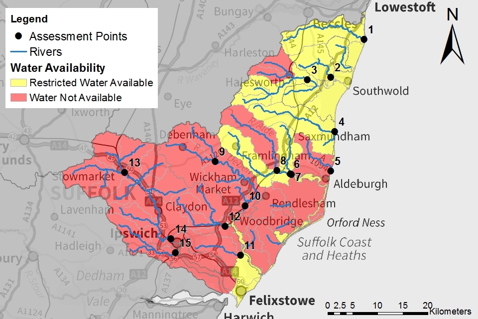
© Environment Agency copyright
3.2 Groundwater resource availability
Abstracting groundwater can impact on overlying surface water bodies. This impact is measured at the surface water AP. We cannot grant new groundwater licences where abstraction is reducing flows to below the indicative flow requirement to help support a healthy ecology. This is based on Q95 flows.
We must also account for:
- the available resource in the aquifer
- the impact of abstraction on protected sites
- the risk of saline intrusion
Groundwater resource availability colours and implications for licensing
We use colours to represent different groundwater availability:
Water available for licensing
Green
Groundwater balance shows groundwater available for licensing. New licences can be considered depending on impacts on other abstractors, designated ecological sites and on surface water.
Restricted water available for licensing
Yellow
Groundwater unit balance shows more water is licensed than the amount available. But the actual situation is sustainable because either:
- recent actual abstractions are lower than the amount available
- management options are in place to deal with known local impacts
In restricted groundwater units no new consumptive licences will be granted. We may also investigate the possibilities for reducing fully licensed risks. Water may be available if you can ‘buy’ (known as licence trading) the entitlement to abstract water from an existing licence holder.
In other units there may be restrictions in some areas, for example in relation to saline intrusion.
Water not available for licensing
Red
Groundwater unit balance shows more water has been abstracted based on recent amounts than the amount available.
We will not grant further licences.
Groundwater availability maps
Map 5 shows the groundwater availability in the East Suffolk catchment. It shows that the opportunities for new consumptive groundwater licences are very limited. This is due to:
- the impact of abstraction on low flows in overlying surface water bodies
- the level of resource available in the aquifers
Water may be available for licensing in AP2 - the River Wang, and in some isolated coastal catchments. Abstraction will be subject to the conditions outlined in this section. Groundwater is restricted or unavailable across the rest of the East Suffolk catchment.
Map 5: Groundwater resource availability colours for East Suffolk ALS
© Environment Agency copyright
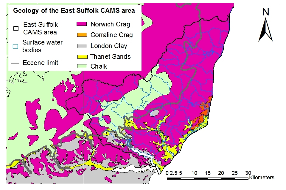
The East Suffolk Chalk and Crag groundwater body incorporates a Chalk aquifer overlain by a Crag and a Sand and Gravel aquifer. Towards the coast a thick layer of London Clay separates the Crag and Chalk aquifers. This clay layer reduces the hydraulic continuity between the Chalk and Crag aquifers. Where the clay layer is thick enough, the impacts of shallow abstractions from the overlying aquifers may be isolated from the Chalk aquifer.
Map 6 summarises the geology of the East Suffolk catchment. The Chalk aquifer is exposed towards the west of the catchment. At the coast it is overlain by the Thanet Sands and then London Clay. These 2 deposits thin progressively inland. Their western edge is described as the Eocene Limit. The Crag aquifer covers much of the area, masking the extent of the London Clay. Where present the clay layer separates the deep Chalk and shallower Crag aquifers.
Map 6: Geology of East Suffolk catchment
© Environment Agency copyright
We cannot allow the impact of groundwater abstraction on surface water flows to increase. In the majority of catchments low flows may not support good ecology. In AP2 – the River Wang, and in some coastal catchments, low flows are sufficient to support good ecology. These catchments are also underlain by a thick layer of London Clay. This means shallow groundwater abstractions do not impact the Chalk aquifer. We may grant a new groundwater licence in these locations if:
- it is not possible for the applicant to apply for a surface water abstraction - this may be due to a lack of access to a river or tributaries
- the abstraction is close to and in direct hydraulic continuity with the surface water body and impacts on flows would be seen with limited delay
- we would apply a HoF condition to protect flows in the surface water body
- the surface water body flows are monitored via a gauging station supporting the enforcement of the HoF condition
- the groundwater abstraction is for the winter period only - this will protect summer surface water flows and is in line with the constraints we would apply to a new surface water abstraction
- the abstraction is not close to the boundary or in the headwaters of the surface water catchment - this is to avoid causing an impact in neighbouring surface water catchments
- the abstraction will not cause or increase the risk of saline intrusion - this may reduce the likelihood of a new abstraction in coastal catchments
- abstraction for the purpose of spray irrigation may be subject to restrictions under Section 57 of the Water Resources Act 1991 - we may restrict abstraction during prolonged periods of exceptional shortage of rain or other emergencies to protect the environment
We will assess each proposal on a case-by-case basis. We will consider the impact of the proposal on:
- the environment
- protected sites
- other abstractors
We may need groundwater modelling to be undertaken at the cost of the applicant in order to determine if the proposal is acceptable.
We may consider a new groundwater licence in other locations if the water is traded from an existing groundwater licence. The licences should be in the same surface water catchment. The maximum volume of water that can be traded from a donor licence is limited to the average annual volume used between 2007 and 2012. This is to ensure that changes in the level of abstraction do not result in deterioration of the groundwater or surface water bodies. Section 5.3 gives more detail on how we manage water rights trading.
We are very unlikely to consider an application for a licence that allows both direct spray irrigation and storage of water for subsequent spray irrigation.
Applications for low consumption purposes such as mineral washing or ground source heat pumps will be considered across the area on a case-by-case basis.
For information on how we will manage groundwater licence variations and renewals refer to section 5.1.
3.3 Resource reliability
If you want to apply for a licence, it’s worth considering the reliability of your surface water abstraction.
By assessing the quantity of water available at different flows it’s possible to see:
- when there is a surplus or deficit of water
- the associated reliability of an abstraction
This is an indication only. Actual reliability of a licence will be discussed when you apply.
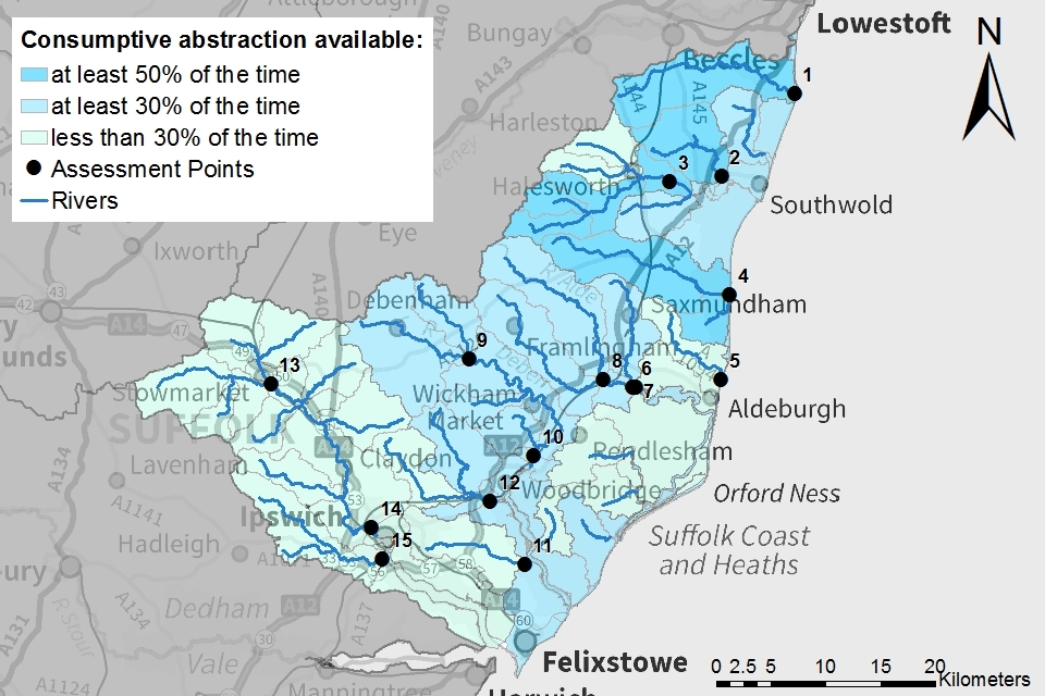
Map 7 gives an indication of the resource availability for consumptive abstraction in the East Suffolk area expressed as a percentage of time. This is based on the number of days water could be abstracted in an average year. We will not accept applications for new consumptive abstractions during the summer accept during high flows. This means the majority of new abstractions will be limited to between November and March inclusive. This is reflected in the resource availabilities described below. In this catchment:
- APs 1, 2, 3, 4: Consumptive abstraction is available at least 50% of the time
- APs 6, 7, 8, 9, 10, 12: Consumptive abstraction is available at least 30% of the time
- APs 5, 13, 14, 15: Consumptive abstraction is available less than 30% of the time
- AP11: This catchment is closed to new consumptive abstractions
Map 7: Surface water resource reliability of the East Suffolk ALS expressed as percentage of time available
© Environment Agency copyright
3.4 Other considerations for resource availability and reliability
We will add constraints to licences such as Hands off Flow (HoF) conditions to protect:
- the environment
- the rights of other abstractors
As a result, when we grant a licence, it doesn’t mean that we guarantee a supply of water. These conditions specify that if the flow in the river drops below what’s needed to protect the environment, abstraction must reduce or stop. In dry years, restrictions are likely to apply more often. This will affect the reliability of supply.
There is no guarantee that we will grant licences even where water is available for abstraction. This is because we have to determine each application on its own merits. Local factors may mean we’re either unable to grant a licence as applied for, or even at all.
New licences within a catchment are usually given a Common End Date (CED), which allows them to be reviewed at the same time. The next CED for this ALS is 31 March 2026 and the subsequent one is 31 March 2038.
More information on our approach to licence renewals and variations is available in section 5.1.
3.5 Impoundments
Applications for impoundments will be dealt with on a case-by-case basis. More information may be found on our water management web pages.
4. How we manage water availability in the East Suffolk ALS area
4.1 Surface water
We assess surface water flows at Assessment points (APs). These are significant points on a river, often where 2 major rivers join or at a gauging station. APs cover multiple surface water bodies.
Groundwater abstraction impacts on the flows of overlying surface water bodies. This impact is measured at the surface water AP.
Table 2 gives an indication of:
- how much water is available for further abstraction
- the associated restrictions we may have to apply to new and varied abstraction licences from the main river
Depending on the nature of the catchment, tributaries to the main river may be subject to different restrictions and quantities. This will be assessed locally on a case-by-case basis.
Each HoF is linked to an AP and is dependent on the resource availability at that AP. In some cases additional restrictions may apply to licences where there is a more critical AP resource availability downstream. This protects the ecological requirements of the river and other water users. This is detailed in the last column of Table 2 if applicable.
All abstraction licence applications are subject to an assessment. This takes account of any local and downstream issues. It may be subject to further restrictions.
Reading from top to bottom in Table 2 are the APs in the East Suffolk ALS area. Reading across the columns you can see the:
- potential HoF that may be applied to a licence
- the approximate volume of water in Ml/d that may be available
Table 2: Summary of licensing approach for the assessment points of East Suffolk ALS
| AP | Name | AP National Grid Reference | Water Resource Availability | HOF Restriction (Ml/d) | Approximate volume available at restriction (Ml/d) | Is there a gauging station at this AP? | Additional restrictions |
|---|---|---|---|---|---|---|---|
| 1 | Lothingland Hundred | TM5361584529 | Water available for Licensing at Q91 | 5.5 | 1 | No | We will not accept applications for new consumptive summer abstractions except during higher flows. |
| 2 | River Wang Wangford GS | TM4694276933 | Water available for Licensing at Q95 | 5.1 | 0.4 | Yes | We will not accept applications for new consumptive summer abstractions except during higher flows. |
| 3 | River Blyth Blyford Bridge | TM4223776479 | Water available for Licensing at Q79 | 10.4 | 0.6 | No | We will not accept applications for new consumptive summer abstractions except during higher flows. |
| 4 | River Yox - Tidal Limit | TM4772466136 | Water available for Licensing at Q95 | 9.0 | 1.4 | No | We will not accept applications for new consumptive summer abstractions except during higher flows. |
| 5 | Hundred River - Sluice below Thorpeness | TM4691058323 | Water available for Licensing at Q32 | 7.5 | 0.7 | No | We will not accept applications for new consumptive summer abstractions except during higher flows. |
| 6 | River Fromus Upstream of confl with Alde | TM3882857670 | Water available for Licensing at Q58 | 5.0 | 0.7 | No | Not critical AP - overridden by AP7. We will not accept applications for new consumptive summer abstractions except during higher flows. |
| 7 | River Alde at Tidal Limit | TM3910157634 | Water available for Licensing at Q58 | 31.8 | 1.8 | No | We will not accept applications for new consumptive summer abstractions except during higher flows. |
| 8 | River Ore Beversham GS | TM3614558371 | Water available for Licensing at Q47 | 11.6 | 0.4 | Yes | We will not accept applications for new consumptive summer abstractions except during higher flows. |
| 9 | River Deben Cretingham GS | TM2384660213 | Water available for Licensing at Q48 | 14.0 | 2.0 | Yes | Not critical AP - overridden by AP10. We will not accept applications for new consumptive summer abstractions except during higher flows. |
| 10 | River Deben | TM2981151367 | Water available for Licensing at Q48 | 26.9 | 2.0 | No | We will not accept applications for new consumptive summer abstractions except during higher flows. |
| 11 | Mill River Kirton Sluice | TM2892941447 | Water available for Licensing at Q7 | 29.6 | 1.7 | No | As flows of Q5 and above need to be preserved as flushing flows into the estuary, this catchment is closed. |
| 12 | River Fynn / Lark - Martlesham Sluice | TM2579247229 | Water available for Licensing at Q55 | 10.5 | 0.1 | No | We will not accept applications for new consumptive summer abstractions except during higher flows. |
| 13 | River Gipping Stowmarket GS | TM0575857943 | Water available for Licensing at Q20 | 68.2 | 41.2 | Yes | Not critical AP - overridden by AP14 We will not accept applications for new consumptive summer abstractions except during higher flows. |
| 14 | River Gipping Horseshoe GS | TM1498244785 | Water available for Licensing at Q20 | 103.6 | 41.2 | No | We will not accept applications for new consumptive summer abstractions except during higher flows. |
| 15 | Belstead Brook | TM1593941950 | Water available for Licensing at Q50 | 10.0 | 0.9 | No | We will not accept applications for new consumptive summer abstractions except during higher flows. |
4.2 Coasts and estuaries
East Suffolk has an extensive coastline divided by the estuaries of:
- Alde-Ore
- Butley
- Deben
- Orwell
When licensing abstraction we must ensure that enough freshwater is flowing into the estuaries to support the ecology and natural processes. Much of East Suffolk’s coast and estuaries are also designated as protected areas. They are home to species-rich habitats and are some of Britain’s most important areas for over-wintering wildfowl and wading birds.
4.3 Protected areas
The Conservation of Habitats and Species Regulations 2017 (Habitats Regulations) provides a very high level of protection to 2 types of designated sites due to their special environment. These are:
- Special Areas of Conservation (SAC), which contribute to biodiversity by maintaining and restoring habitats and species
- Special Protection Area (SPA), which provides protection to birds and their nests, eggs and habitats
As a matter of government policy Ramsar sites, internationally important wetland sites, are treated in the same way as SACs and SPAs. Ramsars, SACs and SPAs are referred to collectively as European sites. Sites of Special Scientific Interest (SSSI) also carry a high level of environmental importance.
Conservation objectives are the overarching objectives for European and SSSI protected sites to maintain or reach favourable condition. These are set by Natural England. The conservation objectives may consist of qualitative and quantitative descriptions. The process for setting targets that underpin the objectives, is described through JNCC approved ‘Common Standards Monitoring Guidance’ (CSMG). These targets are used by Natural England in assessing the condition of European and SSSI protected sites. These quantitative targets are considered by Natural England as a pre-requisite for achieving the conservation objectives for European or SSSI designated sites.
There are 97 protected areas within East Suffolk, many of which are water dependent. In particular large areas of the East Suffolk coastline and estuaries are designated as SACs, SPAs, Ramsar sites and SSSIs. Abstraction licences within or near to these areas may be subject to additional measures to support the conservation objectives of each protected area.
5. Managing the catchment together
5.1 Action on unsustainable abstraction
Managing water abstraction gives details on:
- what an unsustainable abstraction is
- the measures available to resolve environmental issues caused by abstraction
If all licensed water is abstracted there will not be enough water left for the needs of the environment at times of low flow (Q95) at 14 of the 15 APs. Current levels of abstraction are unsustainable at Q95 at 8 APs.
We have taken a number of actions to:
- reduce abstraction
- prevent deterioration
- achieve the objectives of the 2015 RBMP
We have been taking action on revoking or reducing unused and underused licences. We are contacting abstractors who have not used their licence or have only used a small portion of their licensed volumes. We are asking if they still require the water and for what purpose. Abstractors need to supply justification for retaining their licence, such as evidence of future use, contractual agreements to supply water or planning permission. We can revoke licences or reduce volumes where there is not sufficient evidence of need. To date over 387,000 m3 have been removed from unused or underused licences in East Suffolk.
We work with Water Companies to investigate and address the impact of their abstractions on the environment through the Water Industry National Environment Programme.
We manage time limited licence renewals to ensure abstraction is not having a negative impact on the environment now or in the future. There is more information on our current renewal policy later in this section.
We manage licence variations to ensure abstraction is not having a negative impact on the environment now or in the future. There is more information on our groundwater licence variation policy later in this section.
We have adapted our Water Rights Trading and Aggregation policy to prevent deterioration in the status of water bodies. There is more information on our Water Rights Trading policy in section 5.3.
Through the priority catchment we have been working with abstractors to highlight unsustainable abstraction and encourage collaboration between stakeholders to find novel and innovative ways to access water sustainably. There is more information on the priority catchment trials in section 5.2.
Managing time limited licence renewals
A time limited licence will be renewed on the basis that:
- it is sustainable
- there is continued justification of need
- the water is used efficiently
Surface water
All time-limited surface water licences will include a HoF that protects Q95 flows as a minimum. A more restrictive HoF that constrains abstraction to higher flows may be needed to restore abstraction to sustainable levels. We may need to apply a more restrictive HoF to protect or enhance the condition of downstream protected sites. We may have to apply other constraints if HoF conditions are not enough to restore abstraction to sustainable levels.
Groundwater
We will consider renewing time-limited groundwater licences with the same quantities if the requirements of the following can be met:
- the aquifer
- overlying surface water bodies
- associated wetlands
These must be met at current levels of abstraction and if all licensed water is abstracted.
We will reduce the licensed quantities if there is a risk that abstracting all the licensed water could impact on ecology. The 2015 RBMP classifications of water body status are based on the level of annual average abstraction during 2007 to 2012. If average abstraction increases above this baseline level the status of water bodies may deteriorate. We cannot allow this. To reduce the risk of deterioration we are taking a risk-based approach. In the first instance we will reduce licensed volumes to the annual maximum quantity abstracted between 2005 and 2015. The period for spray irrigation purposes is the years 2000 to 2015. This reflects the annual differences in climate and cropping patterns for this abstraction purpose.
In some water bodies capping abstraction to the historic annual maximum volume may not be enough. This is because abstraction was already unsustainable in 2015. We may need to make further changes to licences to restore abstraction to sustainable levels. This could include additional volume reductions. Licences are being renewed until 31 March 2024 in water bodies where we are investigating what measures are required to restore abstraction to sustainable levels.
We will consider renewal of time limited licences on a case-by-case basis in the areas where we have suggested new groundwater licences could be issued (Map 5). We will assess the impact of these abstractions on:
- the status of the East Suffolk Chalk & Crag groundwater body
- any cross-boundary impacts in surrounding surface water bodies
We will cap full licensed volumes where the abstraction could increase the risk of deterioration in water body status.
Managing licence variations
If your water needs have changed you may want to vary your licence. We will assess all proposals on a case-by-case basis. We will consider the impact of the changes on:
- the environment
- protected sites
- other abstractors
Surface water
We may need to add extra constraints to the variation of a licence such as hands off flow (HoF) conditions.
We cannot permit variations that allow or increase the consumptive abstraction of summer water except at high flows.
Groundwater
You will need to provide extra information to support your application if you wish to vary your groundwater licence.
You need to provide justification of need for the variation.
We need to understand if the proposal would change the timing of surface water impacts and whether this would be acceptable. The timing of groundwater abstraction impacts on surface water bodies can vary with:
- abstraction rate
- distance from the watercourse
- characteristics of the aquifer
We may need groundwater modelling to be undertaken at the cost of the applicant to determine if the impact of a change in period is acceptable.
We need to understand whether the proposal could allow an increase in the average level of abstraction. The WFD status of water bodies set out in the 2015 RBMP was based on the actual average level of abstraction occurring before 2015. If average levels of abstraction were to increase above this baseline level water bodies could deteriorate. We cannot allow this. We may add significant restrictions to the licence to prevent this increase in abstraction. Proposals for an increase in abstraction must provide mitigation against the impact.
We have a presumption against applications for the following proposals:
- an increase in annual licensed volumes on existing groundwater licences
- to add winter storage to a summer direct spray irrigation licence
A summer groundwater licence for direct spray irrigation is used dependent on the climate and crop needs. Less water is abstracted in wet periods and more when it’s dry. If the licence is varied to allow the filling of reservoirs, abstraction is less likely to vary with climate. If only some of the licensed volume is used in the summer for direct spray irrigation, the rest could be used to fill the reservoir during winter. This would result in the full licensed volume being taken in multiple years. The average level of actual abstraction would increase and lead to a deterioration in the status of the groundwater body.
We may consider the following proposals subject to adding significant constraints to the licence:
- changing the abstraction purpose from ‘summer’ direct spray irrigation to ‘summer’ storage
- changing the abstraction period and purpose from ‘summer’ direct to ‘winter’ storage
We may need the applicant to undertake groundwater modelling to determine if the proposal is acceptable.
To prevent average annual abstraction increasing due to these variations we would:
- require reservoir capacity to be no more than the annual licenced maximum rate
- add a land condition defining the land area which can be irrigated to the licence
We would consider the following proposals on a case-by-case basis:
- to change a ‘summer’ groundwater abstraction period to all year on a groundwater licence for direct spray irrigation
- to allow a small extension of the abstraction period for a ‘summer’ direct spray irrigation licence - for example to permit abstraction to the end of October instead of September
- for low consumption purposes (for example mineral washing, ground source heat pumps) on a case-by-case basis
- a ‘summer’ to ‘winter’ swap for abstractions close to a watercourse with a proven direct hydraulic connection - however we would encourage the applicant to apply for a surface water abstraction
Trading and aggregation
If unconstrained, water rights trading could result in a rise in annual average abstraction increasing the risk of deterioration in water body status. Section 5.3 gives more information on our approach to trading in East Suffolk.
Aggregation could also result in deterioration. It will involve similar restrictions as water rights trading. Aggregation could include:
- adding a new point of abstraction to the licence (subject to local assessment)
- adding an additional purpose to a licence
- combining multiple licences
To reduce the risk of deterioration from proposals to aggregate licences we will take the following measures:
Temporary single year aggregations:
- the annual volume of each individual licence will be reduced to the maximum annual volume abstracted between 2005 and 2015 or 2000-2015 for spray irrigation purposes
- this annual volume will then be increased by the annual average volume abstracted by the “partner” licence between 2007 and 2012
- the annual volume that the two licences can abstract in combination will be limited to the combined maximum volume abstracted by the two licences in any year between 2005 and 2015 or 2000-2015 for spray irrigation purposes
Permanent aggregations:
- the annual volume of each individual licence will be reduced to the average annual volume abstracted between 2007 and 2012
- these historic average volumes are combined and applied to both licences to give the new maximum annual quantity for each licence
- the annual volume that the two licences can abstract in combination will be limited to the combined historic average volumes
Our full policy gives further details on our approach to water rights trading and aggregation in East Suffolk. View this policy on the Environment Agency priority catchments website.
5.2 Approaches to sustainable water management
We have undertaken a range of catchment focused initiatives. These have formed part of the East Suffolk priority catchment project. Project summaries outline trials of future approaches to water management. Trials initiated in this catchment have taken a collaborative approach. These may be of interest to both new and existing abstractors.
Water trading
Improving the process of water trading is a key area for trials. The East Suffolk Priority Catchment Working Group have progressed this through:
- engaging with the national Temporary Seasonal Trades trial
- supporting third parties with the development of online tools that can help abstractors through the trading process
For more information on Water Rights Trading please see section 5.3.
Understanding the sustainability of abstraction licences
Abstraction is having a negative impact on many of our rivers and groundwater bodies. We have been working with the East Suffolk Water Abstractor Group (ESWAG) to develop a series of maps. These maps indicate where reductions in licence volumes could be required to help protect the environment. For more information see case study 1.
Case study 1: Working with East Suffolk abstractors to understand the security of abstraction licences
Flows in many of our rivers are too low to support expected ecology, particularly in dry periods. We need to address these impacts to meet statutory RBMP objectives. To achieve this, abstracted volumes of water will need to reduce.
We have been working with ESWAG to produce a series of maps. The maps show how agricultural licences could be impacted by these reductions. The aim of the maps is to:
- stimulate conversations between abstractors on their future water needs
- help abstractors identify how these can be met sustainably
The maps show:
- a breakdown of abstraction volumes by sector
- the current impacts of abstraction on flows
- the volumes of water that may need to be reclaimed from licences
At this stage the information is indicative only. The final reductions will depend on many factors. However, understanding the potential scale of the issue is the first step in addressing water scarcity. The next step will involve abstractors, regulators and stakeholders collaborating. This will need to form part of a wider holistic approach to water management in East Suffolk.
For more information on this project please contact the East Suffolk Water Abstractor Group through eswag@btinternet.com.
Groundwater recharge and working with natural processes
This new study provides evidence for the benefits of working with natural processes. It focusses on improving resilience to drought and floods. Natural processes help to store water in the ground and slow down the rate at which it enters river systems. In East Suffolk the study focused on the lower Gipping catchment. The study mapped potential interventions that could help improve water infiltration:
- installing attenuation features
- improving soil and land management techniques
- re-naturalising the channel
- storing more water within the valley floors
The project produced a series of maps. These show where these actions are most likely to be effective. This is a valuable resource for water users considering holistic catchment based solutions. Proposals could help to address water issues in East Suffolk. The full report is available on the Environment Agency priority catchments website.
Catchment resilience
This modelling study focusses on a number of East Suffolk rivers. It investigates why some catchments are more resilient than others to events such as algal blooms. The models assess the impact of different management scenarios. They can help us understand which management tools work best and when to use them. Stakeholder engagement has been key to identify:
- target catchments
- management scenarios to model
The research findings are being used to shape future projects. These will aim to improve the resilience of our rivers and streams to climate change.
Water resources advisory farm visits
We are trialling water resources advisory farm visits. This is in collaboration with:
- local stakeholders
- Natural England’s Catchment Sensitive Farming programme
These visits help identify and share best practice. They also include advice on how to access or make better use of available water. More than 40 farms in East Suffolk and 3 other priority catchments are part of the trial. Visits are underway in the Arun & Western Streams catchment. Visits are planned for East Suffolk in early 2021. If farmers see the positive benefits, we could roll out advisory visits elsewhere.
FRESH4C’s - alternative freshwater resources for coastal areas
FRESH4C’s is a European project involving the East Suffolk priority catchment. It aims to trial innovative technologies for securing sustainable freshwater supply. The project is looking at coastal regions. UK trials have focused on making better use of available water. This is through redistribution and novel storage technologies. For more information see case study 2.
Case study 2 FRESH4C’s: Securing freshwater for the Felixstowe Peninsula
Funding for the FRESH4C’s project has been through:
- European Union’s Interreg 2Seas programme 2014-2020
- European Regional Development Fund
It brings together partners from the UK, Belgium and the Netherlands. We are trialling innovative approaches to securing freshwater supplies in coastal regions. In East Suffolk, the following stakeholders are working together:
- local abstractors
- Environment Agency
- Suffolk County Council
- University of East Anglia
Together we are trialling 2 systems. These are looking at the redistribution and storage of freshwater.
Every year, up to 1 million cubic meters of water drains from fields in the Kingsfleet catchment. It is then pumped into the Deben estuary and lost to sea. That’s enough to fill 400 Olympic sized swimming pools. This activity protects prized agricultural land from flooding. However the freshwater discharge results in damage to precious mudflats and saltmarshes. A group of farmers are constructing a 12km pipeline. This will bring a proportion of this valuable resource back up the catchment. It will be stored in the reservoirs of five farms for use during the drier summer period. Capturing and using this water means:
- farmers will be less reliant on summer abstractions
- the valuable saltmarsh habitats will be better protected
Up to 150,000 cubic metres of the water will be diverted to a Managed Aquifer Recharge and Recovery (MARR) trial. Freshwater will be applied to a shallow recharge lagoon and allowed to soak into the ground. The underlying aquifers will then store this water. It could be re-abstracted in future years. Any surplus water could be allowed to slowly percolate into nearby watercourses to support baseflows.
The project demonstrates how stakeholders working together can make better use of water and build resilience for their businesses. At the same time the environment is being protected.
For more information please visit the FRESH4C’s project website or the Environment Agency’s project webpage.
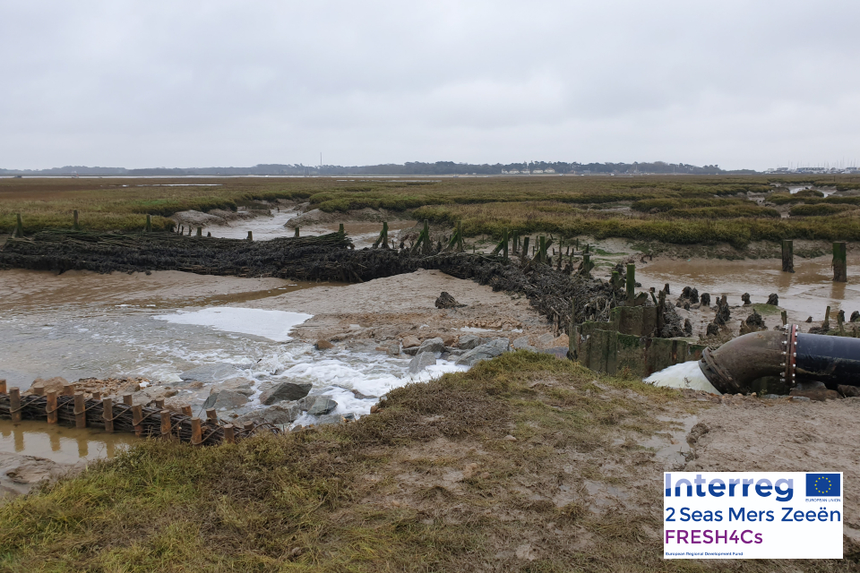
The photograph shows the location of the first UK trial on the Kingsfleet catchment. This is a tributary of the River Deben.
Understanding barriers and opportunities to abstraction
The FRESH4C’s project is also investigating the non-technical barriers to abstraction. This will include social, economic and regulatory barriers. For example, is the cost of schemes to improve access to new sustainable sources of water too high? Can this be overcome and if so how? Evidence is being gathered through stakeholder interviews, surveys, workshops and literature reviews. We will summarise the findings in a roadmap. This will set out how the technology demonstrated in the FRESH4C’s project could be replicated more widely. The roadmap is expected to be published in 2023.
Improving our understanding of the East Suffolk catchment
The Environment Agency is also undertaking a number of studies to improve our understanding of the catchment.
We are assessing the freshwater flow requirements of our estuaries. This will improve our understanding of how we can manage abstraction in these sensitive environments. The findings will help shape our licensing strategy in coastal catchments. They will also help determine if schemes like the FRESH4C’s pipeline can be replicated in other locations.
We are modelling the interaction of the Chalk and Crag aquifers. This is to better understand the impact of abstraction on the individual aquifers. It will inform our understanding of what activities we can permit. The findings will feed into our licensing strategy and assist in drought management. The modelling will also indicate if the FRESH4C’s Managed Aquifer Recharge trial could be replicated in other areas.
Small spring fed streams are a unique feature of the Suffolk sandlings. We are investigating the relationship between flows and the species and habitats of these water bodies. This will support a tailored approach to managing abstraction during times of drought.
The findings from these projects will feed into the FRESH4C’s Roadmap which will be published in 2023. They will also inform future updates of this abstraction licensing strategy.
March 2021 will bring this phase of the priority catchment to a close. The Environment Agency will continue to be involved in catchment focused projects. For example, FRESH4C’s which will help address water scarcity in East Suffolk. The East Suffolk Priority Catchment Working Group are also keen to continue. The group will focus on investigating innovative and catchment-based solutions to the water issues we face. More information on the East Suffolk priority catchment is available on the Environment Agency priority catchments website.
The priority catchment initiative has also been running elsewhere in England. More information on work in these catchments can be found in the updated ALS for the catchments:
5.3 Water rights trading
A water rights trade is where a person sells all or part of their water right, as defined by their abstraction licence(s), to another person on a permanent or temporary basis. In the majority of cases a trade will involve a change in abstraction location and/or use. We will need to approve this through the issue or variation of abstraction licences.
In licensing trades, as with new abstraction licences, we need to make sure that we don’t cause any deterioration in water body status. This is both:
- within the water body/bodies where the trade will take place
- to downstream water bodies
This section provides a guide to the potential for trading in water bodies of a particular ALS water resource availability colour, as shown on Maps 1 to 4.
Guide to the potential trading in water bodies of a particular ALS water resource availability colour
Water available for licensing
Green
There may be opportunities to allow trades of recent actual abstraction and licensed abstraction. But little demand for trading expected within water body as water available for new abstractions.
Restricted water available for licensing
Yellow
There may be opportunities for licence holders to trade up to their full licensed quantities. But the quantities of water available to trade may be restricted once levels of actual abstraction reach sustainable limits. We will not permit licence trades in water bodies where we are taking action to prevent deterioration unless the trade is consistent with achieving water body objectives.
Water not available for licensing
Red
We will only trade recent actual abstraction but no increase in recent actual abstraction is permitted in water body. Licensed abstraction will be recovered for the environment.
To find out more about licence trading please go to our water management web pages.
We have recently developed a new trading policy for the whole of the East Anglia Area which includes the East Suffolk catchment. In licensing trades we need to make sure that we don’t cause any deterioration in water body status. We will consider trades that meet the general criteria outlined below. We will assess each trading proposal on a case-by-case basis and further restrictions may apply. View the full trading policy on the Environment Agency priority catchments website.
Surface water trades
The donor (seller) and recipient (buyer) licences should be abstracting from the same watercourse.
The donor and recipient licences should have the same abstraction period:
- we will not consider applications to move abstraction to the summer period
- we may consider extension of abstraction periods on a case-by-case basis
- we will consider applications to trade summer water to winter
Traded water should be used for the same purpose. We may need to adjust the volume of water that can be traded if the trade involves a change in purpose.
We will usually limit the volume of water available for trade to the average annual volume abstracted by the donor licence during 2007 and 2012.
Groundwater trades
The donor and recipient licence need to abstract from the same aquifer and have comparable effects on surface water features. As a general rule, abstractions should be located in the same surface water body.
In general, the donor and recipient licences should have the same abstraction season:
- we are unlikely to consider moving summer abstraction to winter
- we may consider extension of abstraction periods on a case-by-case basis
Traded water should be used for the same purpose. The volume of water being traded may need adjusting if the trade involves a change in purpose.
If the trading proposal includes an increase in rates of abstraction we may need a pumping test to be undertaken.
We will usually limit the volume of water available for trade to the average annual volume abstracted by the donor licence during 2007 and 2012.
We will reduce the volumes available for abstraction on the donor licence for the duration of the trade. This will reduce the risk of deterioration:
-
for temporary trades of a single year: we will cap the annual volumes on the donor licence to the annual maximum volume abstracted by the donor licence between 2005 and 2015, minus the traded volume - for spray irrigation purposes the annual maximum volume will be based on abstraction between 2000 and 2015
-
for recurrent trades or trades that are greater than one year in duration: we will cap the donor licence to the annual average volume abstracted by the donor licence between 2007 and 2012, minus the traded volume
-
for permanent licence trades: we will permanently reduce the annual volumes on the donor licence to the annual average volume abstracted between 2007 and 2012, minus the traded volumes - if all the 2007-12 recent actual quantity was traded, then the donor licence would cease to exist
We are currently developing new initiatives to support trading in the East Suffolk catchment. This includes:
-
help for trading water rights map: helps abstractors to identify potential trades - it provides information on nearby licences and an indication of the potential for a trade
-
temporary seasonal trades trial: is designed to help abstractors trade water over a single irrigation season - abstractors apply for these trades during a defined ‘trading window’ during the spring. This will be after the publication of the initial irrigation prospects report
-
we are supporting third parties who are developing innovative tools - they will help abstractors identify trading partners and navigate through the trading process
6. Related links
-
Agriculture and Horticulture Development Board (AHDB) website - provides information on effective use of water on livestock farms
-
Catchment Based Approach community website - provides further information on the catchment based approach
-
UK Centre for Ecology and Hydrology Drought Portal - is an interactive portal presenting information on the laterst hydrological situation across the UK
-
Environment Agency, how to apply for a water abstraction or impoundment licence web pages - provide all the information needed to go through the application process to get a licence
-
Environment Agency manage your water abstraction or impoundment licence online web service - allows abstractors to view and share licence information and submit abstraction returns
-
Environment Agency priority catchments website - provides further information about the priority catchment work
-
The Environment Agency National Framework for Water Resources -explores England’s long-term water needs and the importance of planning at the regional scale and link to the catchment scale
-
Linking Environment and Farming (LEAF) Simply Sustainable Water guide - explains six simple steps for managing water quality and industrial use
-
National Farmer’s Union web pages on Irrigation and water resources - provide useful information
-
Natural England’s website - provides further information on protected sites and species
-
Environment Agency and Cranfield University’s guide to planning, designing, constructing and commissioning a water storage reservoir - if you are considering an irrigation reservoir
-
The UK Irrigation Association and Cranfield University - provide a range of irrigation booklets that tackle key issues
-
Waste and Resources Action Programme website has guidance on water efficiency in the food and drink industry
-
Waste and Resources Action Programme website has a guide to water saving devices and practices
7. Glossary
Abstraction - removal of water from a source of supply (surface or groundwater).
Abstraction licence - the authorisation granted by the Environment Agency to allow the removal of water.
Assessment point - a significant point on a river, often where two major rivers join or at a gauging station.
Catchment - the area from which precipitation and groundwater will collect and contribute to the flow of a specific river.
Catchment based approach - partnership working at the river catchment scale to deliver a range of environmental, social and economic benefits while protecting our precious water environments for the benefit of all.
Consumptive abstraction - abstraction where a significant proportion of the water is not returned either directly or indirectly to the source of supply after use. For example for the use of spray irrigation.
Discharge - the release of substances (for example, water, treated sewage effluent) into surface waters.
Environmental flow indicator - flow indicator to prevent environmental deterioration of rivers, set in line with new UK standards set by UKTAG.
Groundwater - water that is contained in underground rocks.
Hands off flow - a condition attached to an abstraction licence which states that if flow (in the river) falls below the level specified on the licence, the abstractor will be required to reduce or stop the abstraction.
Impoundment - a structure that obstructs or impedes the flow of inland water, such as a dam, weir or other constructed works.
Surface water - this is a general term used to describe all water features such as rivers, streams, springs, ponds and lakes.
Water body - units of either surface water or groundwater which we use to assess water availability.
8. Copyright - map images
© Environment Agency copyright and/or database right 2020. All rights reserved. This map includes data supplied under licence from: © Crown Copyright and database right 2020. All rights reserved. Ordnance Survey licence number 100024198.
9. Contact details for further information
For local water resources advice contact the East Anglia - East Integrated Environment Planning Team. You can either call or email the team:
- call 03708 506 506 (calls cost no more than a national rate call to an 01 or 02 number)
- email enquiries@environment-agency.gov.uk