East Devon abstraction licensing strategy
Updated 23 June 2022

© Crown copyright 2022
This publication is licensed under the terms of the Open Government Licence v3.0 except where otherwise stated. To view this licence, visit nationalarchives.gov.uk/doc/open-government-licence/version/3 or write to the Information Policy Team, The National Archives, Kew, London TW9 4DU, or email: psi@nationalarchives.gov.uk.
Where we have identified any third party copyright information you will need to obtain permission from the copyright holders concerned.
This publication is available at https://www.gov.uk/government/publications/east-devon-abstraction-licensing-strategy/east-devon-abstraction-licensing-strategy
1. About the licensing strategy
1.1 Overview
This abstraction licensing strategy (ALS) sets out how we manage new and existing abstraction and impoundments within the East Devon catchments. It provides an overview of how water resources are sustainably managed to:
- provide water for abstraction
- protect the environment
Managing water abstraction provides the national framework to ensure there is enough water for the future needs of both people and the environment. The abstraction licensing strategy is the local water resource strategy that meets those national requirements, as described in the River Basin Management Plan (RBMP 2015).
The strategy also describes the collaboration with local partners and stakeholders undertaken to achieve sustainable management of water resources. This reflects the unique characteristics of the East Devon catchments.
The abstraction pages on GOV.UK provides further advice on:
- who needs an abstraction or impoundment licence
- how to apply for an abstraction or impoundment licence
1.2 How is the licensing strategy set out?
The following is a summary of what each section covers:
Catchment overview - sets out additional information about the East Devon catchments and the influences and pressures on water availability
Water resource availability - explains how much water is available for abstraction in the East Devon catchments
How we manage water resource availability - explains the local licensing approach for the East Devon catchments and the local restrictions that may be required
Managing the catchment together - details the collaborative approaches to sustainable water management in the East Devon catchments with particular focus on the Otter priority catchment
Related links - are listed for further information on water resource management
Glossary - explains technical terms included throughout this document
Contact details - on how to get in touch
1.3 Collaborative and sustainable water management
Our long-term goal is to develop a stronger catchment focus for water resource management throughout the East Devon catchments through collaborative working.
We are developing and testing innovative solutions to achieve greater access to water and address unsustainable abstraction through the priority catchment initiative. We have selected priority catchments where:
- there is unmet demand for water and/or there are concerns that abstraction is damaging the ecology
- there is potential for water to be shared amongst abstractors
- there are a number of abstractors who we can work with to trial new and innovative ways of managing water abstraction
The River Otter is one of the East Devon catchments and was selected as a priority catchment in 2019 through the Defra water abstraction plan. See map 1.
By working with abstractors and catchment groups we aim to:
- develop local solutions to existing pressures on water resources
- prepare for the future
More details regarding the Otter priority catchment are provided in section 2.5 and section 5, managing the catchment together.
2. Catchment overview
2.1 Landscape and land use
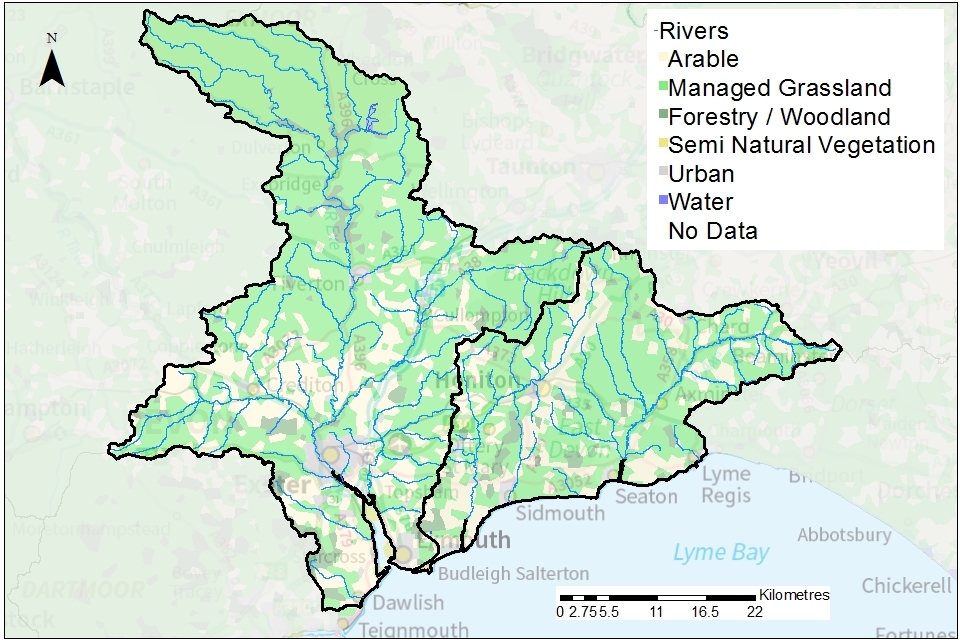
The East Devon catchments cover an area of 2,271km2 in south west England (map 1). It is divided into 2 areas:
- Exe catchment
- Otter, Sid, Axe and Lim catchment
Map 1: overview of the East Devon catchments

© Environment Agency copyright
The landscape is highly varied but is dominated by rolling agricultural land, interspersed with urban centres at:
- Exeter
- Tiverton
- Sidmouth
- Axminster
-
population: 449,500 (estimated from ONS 2019 mid-year local authority estimates)
-
3,133 farms covering 180,240 hectares of farm land (Defra farm statistics)
The diverse geology has helped shape the plateaus, scarp slopes, valleys and coastal plains of the East Devon catchments. It is visible along the Jurassic Coast.
Map 2: land use across the East Devon catchments
© Environment Agency copyright
Agricultural land-use is dominated by permanent grassland which supports the livestock sector, with arable and woodland also forming much of the landscape.
| Land Use Type | Proportion of catchment (%) |
|---|---|
| Permanent grassland | 51.5% |
| Arable | 24.9% |
| Urban | 7.4% |
| Forested | 14.9% |
| Other | 1.3% |
Land use statistics based upon LCM2019 © NERC (UKCEH) 2020.
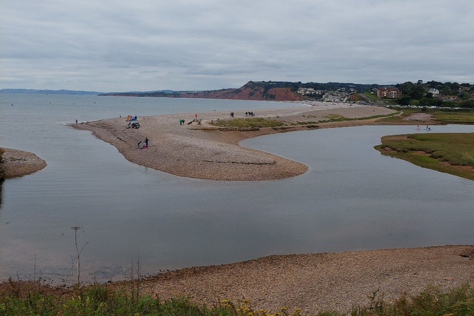
The photograph shows the River Otter flowing into the sea at Budleigh Salterton. The red cliffs in the background are composed of the Otter Sandstone and the Budleigh Salterton Pebble Beds.
2.2 Environment
The East Devon catchments include a diverse range of protected areas of local and national environmental importance that are protected by UK law. These important grasslands, heathlands, wetlands and woodlands include:
- 7 Special Areas of Conservation (SAC)
- 2 Special Protection Areas (SPA)
- 60 Sites of Special Scientific Interest (SSSI)
These can be viewed on Magic Map.
Many of these sites have a surface water or groundwater dependence to maintain their quality and may therefore be affected by abstraction. It is our responsibility to ensure we do not authorise abstraction that will have an adverse effect on these protected sites. Section 4.2 (Protected areas) provides information on how we manage water availability near groundwater and surface water dependent protected sites.
2.3 Water Resources
Surface Water
The East Devon catchments comprise the following 5 rivers:
- River Exe
- River Otter
- River Sid
- River Axe
- River Lim
These emerge from high ground in the north and flow in a southerly direction towards the coast between Dawlish and Lyme Regis.
Under the requirements of the Water Framework Directive (WFD) a total of 81 river water bodies have been defined within the East Devon catchments. Water bodies are the surface water or groundwater units on which we carry out resource assessments.
In addition, there are three lake waterbodies defined in the catchment:
- Otterhead Reservoir (Otter)
- Squabmoor Reservoir (Otter)
- Wimbleball Reservoir (Exe)
A total of 111 licensed surface water abstractions are currently authorised in the East Devon catchments. These licences authorise the abstraction of up to 259 million cubic metres of surface water per year.
Over the period 2013 to 2018 approximately 155.8 million cubic metres of surface water was abstracted from the East Devon catchments per year. This is equivalent to 60% of the total licensed surface water abstraction quantity.
These licence and abstraction figures do not include:
-
non-consumptive abstractions for hydroelectric power (HEP) generation
-
surface water abstractions that do not require a licence
Information on activities that do not need an abstraction licence can be found on GOV.UK.
The proportion of surface water abstracted by different sectors, based on total licensed quantities not including HEP generation is shown below.
| Abstraction licence sector | Total licensed surface water quantity (cubic metres per year) | Proportion of total licensed surface water quantity (%) |
|---|---|---|
| Public water supply | 61,203,000 | 23.6 |
| Other potable uses | 13,635,000 | 5.3 |
| Agriculture | 148,928,000 | 57.5 |
| Industry and commercial | 4,751,000 | 1.8 |
| Amenity and environmental | 22,583,000 | 8.7 |
| Energy generation (not including HEP) | 7,907,000 | 3.1 |
| Total | 259,007,000 | 100 |
Groundwater
Groundwater is stored in aquifers and provides an important water resource that can be abstracted from boreholes, wells and springs. Groundwater also interacts with rivers in important ways:
- groundwater emerging from springs that commonly feed the headwaters of the rivers
- groundwater baseflow through the riverbed that supports river flow
These interactions are most important at times of low flow.
The diverse geology of the East Devon catchments means that groundwater is highly variable in both the quantities found and its chemical quality. A total of 15 groundwater bodies are wholly or partially present in the East Devon catchments. These groundwater bodies underlie 98% of the total catchment area.
The Otter Sandstone is the most important aquifer in the East Devon catchments. It is heavily utilised by South West Water to provide public water supply. It also sustains flow in the River Otter and its tributaries. The other geological formations in the East Devon catchments provide less groundwater. However, they are important in supporting river flow and smaller commercial abstractions or private water supplies.
Given its importance, the Otter Sandstone aquifer has also been classified a groundwater management unit (GWMU). Computer models are often developed due to the complexity of groundwater / surface water interactions in GWMUs. A groundwater model has been developed for the Otter Valley GWMU (see section 5.1). The Otter Valley GWMU has the same boundary as the Otter Valley groundwater body.
A total of 208 licensed groundwater abstractions are currently authorised in the East Devon catchments. These licences authorise the abstraction of up to 27.4 million cubic metres of groundwater per year. This is equivalent to approximately 10% the total licensed surface water abstraction.
Over the period 2013 to 2018 approximately 16.9 million cubic metres of groundwater was abstracted from the East Devon catchments per year. This is equivalent to 62% of the total licensed quantity of groundwater.
The proportion of groundwater abstracted by different sectors, based on total licensed quantities is summarised below:
| Abstraction licence sector | Total licensed groundwater quantity (cubic metres per year) | Proportion of total licensed groundwater quantity (%) |
|---|---|---|
| Public water supply | 18,990,000 | 69.4 |
| Other potable uses | 1,880,000 | 6.8 |
| Agriculture | 3,380,000 | 12.3 |
| Industry and commercial | 1,612,000 | 5.9 |
| Amenity and environmental | 557,000 | 2.0 |
| Energy generation (not including HEP) | 960,000 | 3.5 |
| Total | 27,379,000 | 100 |
Water resource sustainability
We aim to ensure the sustainable use of water resources through the resource assessment approach and tools described in section 3 and 4. We define the needs of the river ecology using the Environmental Flow Indicator (EFI).
Where river flow is already below that needed by its ecology, we are unable to issue new abstraction licences. We may also add conditions to a licence to protect flow, ecology and other water users (see section 4). Under WFD we classify such water bodies as not supporting good status. We use surveys to understand if this reduction in flow is causing an impact on river ecology or whether it represents a future risk. Where this is the case, we would look to take action to restore flows.
If river flow is sufficient to maintain the long-term health of its ecology, we classify it as having Good Ecological Status (GES) under WFD.
WFD status in the East Devon catchments 2019
Of the 81 WFD river water bodies in the East Devon catchments 3 did not support good status due to river flow:
- Lower River Otter in the Otter catchment
- Lower Barle in the Exe catchment
- Middle Creedy in the Exe catchment
Of the 3 WFD lake water bodies in the East Devon catchments one did not support good status due to river flow:
- Otterhead reservoir in the Otter catchment
Of the 15 WFD groundwater bodies wholly or partially present in the East Devon catchments one was of poor groundwater quantitative status:
- Otter Valley
Further measures and programmes have been applied both at a local and national level to reduce the impact on water resources:
-
licence reductions of 405,054 cubic metres per year through the unused and underused licence project
-
review of abstraction licences in water bodies in the River Otter and River Exe catchments to ensure there is sufficient flow for ecology
-
use of the groundwater-surface water computer model for the Otter Valley to evaluate impacts on river flow (see section 5.1)
2.4 Climate change
Climate change represents one of the greatest challenges for future sustainable management of water resources in the East Devon catchments. Climate change will likely impact on the quantity and seasonal availability of water resources.
The projected climate change impacts on rainfall and river flow for south west England by the 2050s are:
-
rainfall to decrease by 45% in the summer but increase by 41% in the winter
-
low flows to be 82% lower but peak river flows to be 40% higher
Climate change projections are estimated using data from UKCP09, consistent with a 4ºC rise by 2100. Further details on the assumptions used can be found in the Environment Agency Climate impacts tool.
The Otter Valley groundwater model has been used to assess the impact that climate change may have on water resources. See section 5.1 for more details.
2.5 The priority catchment initiative and partnership working
The River Otter was selected as a priority catchment in 2019 as part of phase 2 of the Defra water abstraction plan. It was chosen as a priority catchment for the following reasons:
- the current level of abstraction means there is insufficient water in the River Otter for wildlife, at certain times of the year
- there are several collaborative projects already underway that are evaluating innovative approaches for managing water resources in the catchment
- there is potential to share water amongst abstractors
- current forecasts for climate change in terms of river flows and sea level rise indicate more acute pressures on water resources in the future
As a priority catchment, we aim to extend our work with water users and other partners to explore modern ways of managing water. We are working to build our partnership across sectors including:
- water companies providing public water supply
- agriculture
- the environment
- industry
- flood risk management
Through this work we aim to co-develop solutions which are good for the environment, people and business.
3. Water resource availability in the East Devon catchments
3.1 Resource assessment
Resource assessment is at the heart of abstraction management. To manage water effectively we need to understand how much, where and when water is available, after considering the needs of the environment. The main components of this assessment are:
- water resource allocation for the environment defined as a proportion of natural flow, known as the Environmental Flow Indicator
- Fully Licensed (FL) scenario - the situation if all abstraction licences were being used to their full quantity
- Recent Actual (RA) scenario – the amount of water actually abstracted on average over the previous 6 years
We have a monitoring network to measure river flows and groundwater levels. We use this data, along with our catchment knowledge to inform the assessment.
River flow changes naturally throughout the year and from year to year. We need to maintain flow variability to protect the ecology of the river. We use river flow statistics to help to do this. River flow statistics are expressed as the percentage of time that a certain flow is exceeded. Resource availability is calculated at 4 specific flow regimes:
- Q30 – the high flow of a river which is exceeded on average for 30% of the time, therefore on average you would expect the river flow to be below the Q30 for 256 days per year
- Q50 – the flow of a river which is exceeded on average 50% of the time, therefore on average you would expect the river flow to be below the Q50 for 183 days per year
- Q70 – the flow of a river which is exceeded on average for 70% of the time, therefore on average you would expect the river flow to be below the Q70 for 110 days per year
- Q95 – the low flow of a river which is exceeded on average for 95% of the time, therefore on average you would expect the river flow to be below the Q95 for 18 days per year
This information gives a realistic picture of what the current resource availability is within a given water body.
3.2 Surface water availability
The method for calculating the surface water resource availability is explained in Managing water abstraction. Water availability is calculated at selected assessment points (APs). Within the East Devon catchments separate APs are defined for the Exe catchment and the combined Otter, Sid, Axe and Lim catchment. All APs are shown in maps 3 to 6.
There are 11 APs in the Exe catchment:
- AP1, Trews Weir (River Exe, at Exeter)
- AP2, Cowley (River Creedy, upstream of confluence with River Exe)
- AP3, North Bridge (River Exe, upstream of confluence with River Culm)
- AP4, Tiverton Exe (River Exe at Tiverton)
- AP5, Brushford (River Barle, upstream of confluence with River Exe)
- AP6, Weir Bridge (River Exe, upstream of confluence with River Haddeo)
- AP7, Tiverton Lowman (River Lowman at confluence with River Exe at Tiverton)
- AP8, Stoke Cannon (River Culm, at its confluence with River Exe)
- AP9, Woodmill (River Culm, to the south of Cullompton)
- AP10, Uffculme (River Culm, at Uffculme)
- AP11 Clyst St Mary (River Clyst, upstream of Exe Estuary at Topsham)
There are 9 APs in the combined Otter, Sid, Axe and Lim catchment:
- AP1, Otterton (downstream River Otter, downstream of Otterton Mill)
- AP2, Fairmile (River Tale, upstream of confluence with River Otter)
- AP3, Fenny Bridges (River Otter at Fenny Bridges)
- AP4, Sidmouth (Mouth of the River Sid)
- AP5, Colyford (River Coly, at its confluence with River Axe)
- AP6, Axe Bridge (downstream River Axe, upstream of Axe Estuary and confluence with River Coly)
- AP7, Kilmington (River Yarty, upstream of confluence with Corry Brook)
- AP8, Weycroft (River Axe, upstream of Axminster)
- AP9, Lyme Regis (Mouth of River Lim at Lyme Regis)
APs have not been defined for the following rivers due to their short length:
- Dawlish Water (west of Exe estuary)
- River Ken (west of Exe estuary)
- Matford Brook (west of Exe estuary)
- Alphin Brook (west of Exe estuary)
- Polly Brook (east of the Exe Estuary)
- Branscombe Brook (west of Lyme Regis)
Bespoke resource assessments will be carried out for abstraction proposals in these water bodies.
Water resource availability colours and implications for licensing
We use colours to represent different surface water availability at the 4 flows described in Section 3.1 - (Q30 – high flow; Q50; Q70; and Q95 – low flow):
Water available for licensing
Green
There is more water than required to meet the needs of the environment. New licences can be considered depending on local and downstream impacts.
Restricted water available for licensing
Yellow
Fully Licensed flows fall below the EFI.
If all licensed water is abstracted there will not be enough water left to maintain a healthy ecology in the river. No new consumptive licences would be granted. It is likely we’ll be taking action to reduce fully licensed risks. Water may be available if you can ‘buy’ the entitlement to abstract water from an existing licence holder (known as water rights trading) although it may be for reduced quantities.
Water not available for licensing
Red
Recent Actual flows are below the EFI.
Recent actual abstracted quantities are already resulting in flows below that required to maintain a healthy ecology in the river. No new consumptive licences would be granted. Any water rights trading proposal in these water bodies would need to demonstrate improvements in flow.
Water availability maps
The surface water availability colours for the Exe, Otter, Sid, Axe and Lim catchments are presented in maps 3 to 6 and summarised in tables 1 and 2.
Map 3: surface water resource availability colours at Q30 for the East Devon catchments
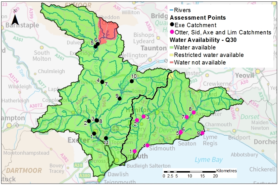
© Environment Agency copyright
Map 4: surface water resource availability colours at Q50 for the East Devon catchments
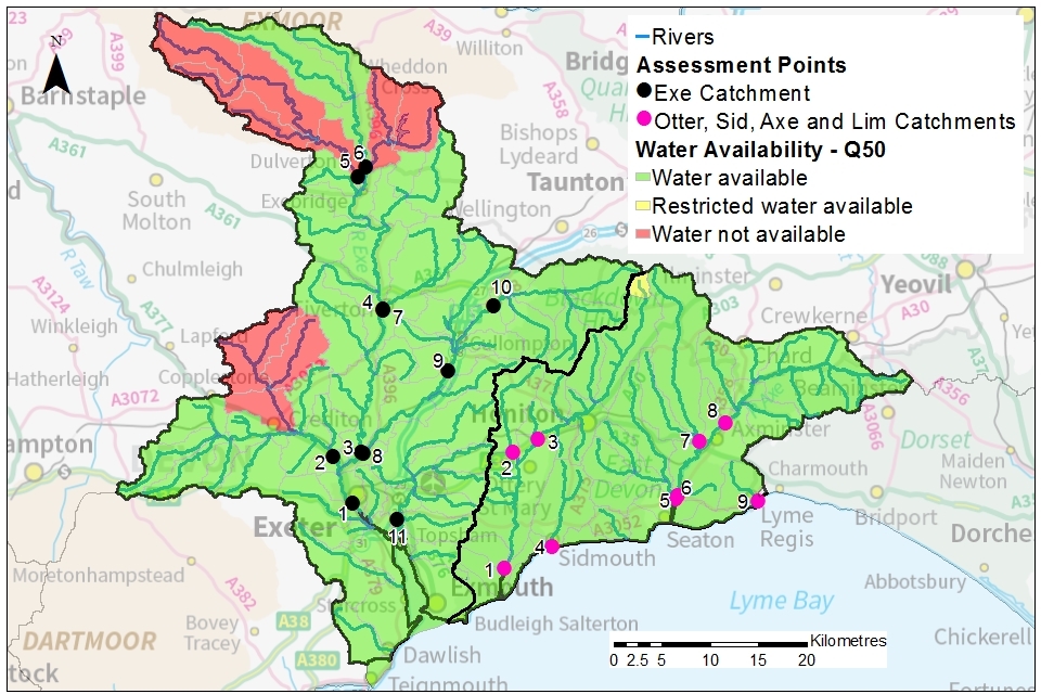
© Environment Agency copyright
Map 5: surface water resource availability colours at Q70 for the East Devon catchments
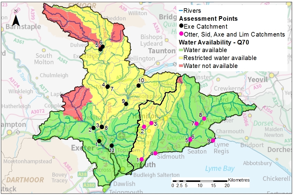
© Environment Agency copyright
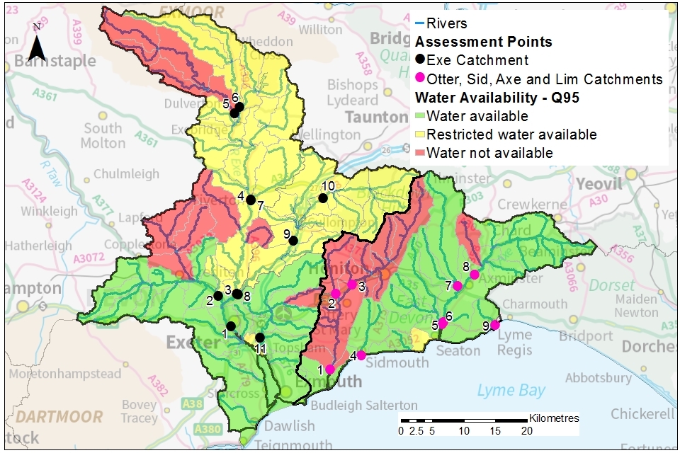
Map 6: surface water resource availability colours at Q95 for the East Devon catchments
© Environment Agency copyright
Table 1: summary of maps 3 to 6 – water availability at each assessment point by flow category in the Exe catchment
| Assessment point | Name | Q30 | Q50 | Q70 | Q95 |
|---|---|---|---|---|---|
| 1 | Trews Weir | Available | Available | Available | Available |
| 2 | Cowley | Available | Available | Available | Available |
| 3 | North Bridge | Available | Available | Restricted | Restricted |
| 4 | Tiverton Exe | Available | Available | Restricted | Restricted |
| 5 | Brushford | Available | No water available | No water available | No water available |
| 6 | Weir Bridge | Available | Available | Restricted | Restricted |
| 7 | Tiverton Lowman | Available | Available | Restricted | Restricted |
| 8 | Stoke Canon | Available | Available | Restricted | Restricted |
| 9 | Woodmill | Available | Available | Restricted | Restricted |
| 10 | Uffculme | Available | Available | Restricted | Restricted |
| 11 | Clyst St Mary | Available | Available | Available | Available |
Note: APs 2,4 and 11 contain some sub-catchments with restricted or no water available as shown in maps 3 to 6
Table 2: summary of maps 3 to 6 – water availability at each assessment point by flow category in the Otter, Sid, Axe and Lim CAMS catchments
| Assessment point | Name | Q30 | Q50 | Q70 | Q95 |
|---|---|---|---|---|---|
| 1 | Otterton | Available | Available | Restricted | No water available |
| 2 | Fairmile | Available | Available | Restricted | No water available |
| 3 | Fenny Bridges | Available | Available | Restricted | No water available |
| 4 | Sidmouth | Available | Available | Available | Available |
| 5 | Colyford | Available | Available | Available | Available |
| 6 | Axe Bridge | Available | Available | Available | Available |
| 7 | Kilmington | Available | Available | Available | Available |
| 8 | Weycroft | Available | Available | Available | Available |
| 9 | Lyme Regis | Available | Available | Available | Available |
Note: APs 3 and 8 contain some sub-catchments with restricted or no water available as shown in maps 3 to 6
3.3 Groundwater resource availability
Groundwater availability is a measure of how much groundwater is available for abstraction after the river flow requirements for ecology have been met.
Groundwater availability inside the Otter Valley GWMU has been assessed using the Otter Valley groundwater model. See section 5.1 for more details.
Outside of the Otter Valley GWMU, groundwater availability is determined by an assessment that considers:
- the recharge to that groundwater body
- the groundwater contribution to rivers crossing that groundwater body
- the flow needed to support ecology
The resource availability for each groundwater body in the East Devon catchments is shown in map 7 in section 3.3.
Groundwater resource availability colours and implications for licensing
We use colours to represent different groundwater availability.
Water available for licensing
Green
New licences can be considered.
Restricted water available for licensing
Yellow
If all licensed groundwater is abstracted there may not be enough water left to maintain a healthy ecology in rivers. This applies to rivers wholly within or crossing the groundwater body.
There is a presumption that no new consumptive licences will be granted that cause flow to fall below the EFI. It is likely we’ll be taking action to reduce fully licensed risks. Water may be available if you can ‘buy’ the entitlement to abstract water from an existing licence holder (known as water rights trading) although it may be for reduced quantities.
Water not available for licensing
Red
More groundwater has been abstracted recently, than the amount available. New groundwater licences could reduce baseflow to rivers where flow is already below the EFI.
There is a presumption that no new consumptive licences will be granted that cause flow to fall further below the EFI. Any water rights trading proposal in these groundwater bodies would need to demonstrate improvements in flow.
Groundwater availability maps
Groundwater resource availability in the East Devon catchments is shown in map 7. Areas showing no colour within the catchments’ boundary indicate unproductive strata.
Map 7: groundwater resource availability for groundwater bodies in the East Devon catchments
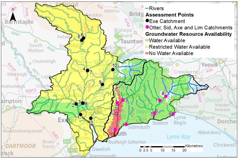
© Environment Agency copyright
The Otter Valley groundwater model shows that reduced river flow exists between Ottery St Mary and the coast due to groundwater abstraction. There is a presumption that no new consumptive licences will be granted at any time of year in the Otter Valley GWMU shown in red.
There is restricted groundwater availability in the following groundwater bodies, depending on abstraction location:
- Central Devon and Exe - Aylesbeare Mudstone
- Permian Aquifers in Central Devon
There is groundwater available in all other groundwater bodies.
3.4 Resource reliability
If you want to apply for a licence to abstract surface water, it’s worth considering the reliability of that abstraction. By assessing the quantity of surface water available at different flows it’s possible to see:
- when there is a surplus or deficit of water
- the associated reliability of an abstraction
Map 8 gives an indication of the resource availability for consumptive abstraction of surface water in the East Devon catchments. This is expressed as a percentage of time.
In the Exe catchment area:
- APs 1, 2, 11: water is available for consumptive abstraction at least 95% of the time (or 347 days per year)
- APs 3, 4, 6, 7, 8, 9,10: water may only be available for consumptive abstraction 50% of the time (or 183 days per year)
- APs 5: water may only be available for consumptive abstraction 30% of the time (or 110 days per year)
In the combined Otter, Sid, Axe and Lim catchment areas:
- APs 1, 2 and 3: water may only be available for consumptive abstraction 50% of the time (or 183 days per year)
- APs 4, 5, 6 7 and 8: water is available for consumptive abstraction at least 95% of the time (or 347 days per year)
Map 8: surface water resource reliability of the East Devon catchments expressed as percentage of time available

© Environment Agency copyright
3.5 Other considerations for resource availability and reliability
In addition to the resource assessment, we must also consider other local factors, including:
- the impact on protected sites
- the impact on other abstractors
- long-term abstraction sustainability
- the risk of saline intrusion
This means we may be unable to grant a licence or may need to apply local restrictions which limit the abstraction activity (section 4.2).
Anyone intending to abstract more than 20 cubic metres per day from a groundwater source needs an abstraction licence. They are also likely to need a groundwater investigation consent (GIC) from the Environment Agency under section 32 of the Water Resources Act. Applicants will be required to supply appropriate supporting information.
4. How we manage water availability in the East Devon catchments
The principal tool for managing water availability is through the abstraction licensing process which we apply across England. By assessing abstraction proposals and implementing restrictions we aim to protect the environment and other abstractors. We add local restrictions to the general principles.
4.1 General principles
New applications
New licences issued in the East Devon catchments will be time limited and issued with a Common End Date (CED). This allows all authorisations to be reviewed at the same time. CEDs are set on a 12-year cycle. The next CEDs are as follows:
| Catchment | Next CED | Following CED |
|---|---|---|
| Exe | 31 March 2028 | 31 March 2040 |
| Otter, Sid, Axe and Lim | 31 March 2029 | 31 March 2041 |
If an application is made within 6 years of a CED, we will generally apply the subsequent CED to any licence granted. This means that the initial CED will give a licence duration of between 6 and 18 years.
Short-term licences may be necessary where monitoring is required to reduce uncertainty regarding the impact of an abstraction.
Variations and renewals
Licence variations and the renewal of time-limited licences will be re-issued provided it can be shown:
- the abstraction is sustainable
- there is continued justification of need
- the water is used efficiently
If this is not the case, we may apply more restrictive conditions to the licence.
If your water abstraction licence needs to change, we will consider the impact of those changes on the environment and other abstractors before issuing a variation.
In catchments where water resources are not available or are restricted, we may seek to recover water through the licence renewal or variation process.
Guidance on renewing a time-limited licence can be found on GOV.UK.
Non-consumptive abstractions
An abstraction is considered non-consumptive where the water removed is returned to the river at, or near, the point of abstraction without any significant loss. Whilst non-consumptive abstraction should have a neutral impact on water resources, we may apply restrictions to minimise effects on flow-depleted reaches. Additional restrictions may also be applied if a non-consumptive abstraction removes water from one catchment and discharges to another.
The most common type of non-consumptive surface water abstraction in the East Devon catchments are those used for HEP. Use our contact details to obtain guidance on HEP applications.
Water Industry National Environment Programme
Every 5 years, the Water Industry National Environment Programme (WINEP) sets out the requirements on water companies to address unsustainable abstraction. The current WINEP period is April 2020 to March 2025.
In the East Devon catchments, South West Water have undertaken 3 WINEP investigations and Wessex Water have undertaken one. These investigations aim to:
- assess the impact abstractions are having on river flows and groundwater levels
- identify how the licences can be changed to restore flows to protect ecology
Actions identified, including habitat improvements, will be delivered in the next WINEP period.
In the future, the process to identify actions for the WINEP will become more collaborative with wider engagement to deliver multiple benefits for catchments. This new process will be used for the next WINEP (2025 to 2030).
Historic licences
There are some historic licences that do not meet modern standards for the protection of flow and river ecology. These licences are not time limited and do not go through the renewal process outlined in section 4.1.
For these licences of concern, we will work with the licence holder to negotiate changes to improve river flow. Where we are unable to progress voluntary licence changes, we may serve a Notice to enforce those changes. Compensation may be payable to the licence holder.
4.2 Local restrictions
We may add local restrictions to the general principles to protect:
- specific river flows
- river ecology (including fisheries)
- the rights of other abstractors
These are determined on a case-by-case basis. You may be asked to provide further information to support your application. Local restrictions applied in the East Devon catchments are summarised in tables 3, 4 and 5.
Hands off flows and hands off levels
To maintain river flow we may restrict surface water abstraction by applying a hands off flow (HoF) or hands off level (HoL) condition. When the river flow or river level measured at a specified point falls below the set value, abstraction must stop. A HoF or HoL is linked to an AP (using the most appropriate flow gauging station) and is dependent on the resource availability at that AP. New surface water licence applications are likely to have HoF restrictions applied, as indicated in tables 3 and 4.
Where groundwater abstraction impacts surface water flow, we may also apply a HoF or HoL condition as summarised in table 5.
In some circumstances we may need to protect very low flows, below Q95. We do this by applying a HoF condition called the Minimum Residual Flow (MRF).
Compensation flows
To ensure rivers continue to flow downstream of a lake, reservoir or impoundment we may require a minimum continuous outflow (compensation flow) to be maintained. In the East Devon catchments compensation flows are required to support low flows downstream of the following reservoirs:
- Otterhead Reservoir
- Wimbleball Lake
River flow augmentation
Where historical groundwater abstraction has been shown to impact river flow, we have in certain circumstances required river flow augmentation. This requires the abstractor to return some of the pumped groundwater into the river to improve flow and protect ecology.
River augmentation has only been applied in the Otter Valley groundwater body. We have used the Otter Valley groundwater model to determine when river augmentation must start and when it can stop.
We are unlikely to grant new abstraction licences which rely on river flow augmentation to protect flow and river ecology.
Protected areas
The Environment Agency works with our partners, Natural England, to protect the natural flow regime of designated conservation sites described in section 2.2.
Special Areas of Conservation with a potentially important surface water or groundwater dependence are:
- East Devon Pebblebed Heaths SAC
- River Axe SAC
- Dawlish Warren SAC
- Exmoor Heaths SAC
- Exmoor and Quantock Oakwoods SAC
The River Barle and Barle Valley are both designated SSSIs, that cross the Exmoor and Quantock Oakwoods SAC.
Designated estuaries in the East Devon catchments include:
- The Exe Estuary SSSI and SPA
- Otter Estuary SSSI
Where we think a proposed abstraction could impact on a designated conservation site you may be required to provide additional supporting information. This will allow us to complete the required statutory assessment. We may not be able to issue a licence or may put restrictions on the abstraction to manage the risk to those protected sites.
For some protected areas Natural England publishes river flow targets as part of their revised Common Standards Monitoring Guidance (CSMG). These CSMG targets are often more restrictive than the standard flow targets that we typically apply. In the East Devon catchments targets have been set for:
- the River Axe SAC
- the River Barle SSSI
We must consider these targets as part of our licence determination process. Opportunities for new abstractions which will impact on river flows within these designated sites may therefore be limited.
The East Devon Pebblebed Heath SAC has an ecology that relies upon groundwater emerging at the ground surface. Abstraction licence applications therefore require supporting information which assesses the risk to the ecology within the SAC.
All new surface water abstractions will also be assessed in relation to their potential impact on biodiversity and fisheries. Site-specific licence conditions, that may include monitoring, may be required to protect these features.
Coasts and estuaries
The East Devon coastline faces growing challenges due to climate change. Sea level rise, extreme rainfall events and increasing frequency of storms have the potential to affect water availability and our coastal protected areas.
Groundwater abstraction may pull sea water into freshwater coastal aquifers, thereby reducing groundwater availability. To mitigate this saline intrusion effect we may:
- apply a HoL
- require groundwater quality monitoring
- issue a licence for a reduced quantity
As shown in table 5 a HoL has been prescribed for a coastal abstraction borehole in the Otter Valley groundwater body.
In response to the increasing pressure on our coastlines and estuaries, managed realignment schemes are often considered. These schemes attempt to re-establish a more natural and sustainable coastal alignment by the landward retreat of coastal defences and restoration of estuarine habitats. Managed realignment can therefore result in saltwater inundation of previously protected coastal areas.
The Lower Otter Restoration Project (LORP) is the only managed realignment scheme within the East Devon catchments and is described in section 5.1. For any application within the Lower Otter we must consider the changed saltwater inundation patterns resulting from the scheme.
Summary of local restrictions
The local restrictions applied in the East Devon catchments are summarised in tables 3, 4 and 5.
Table 3: surface water availability and local restrictions in the Exe catchment
| AP | Name | Surface Water Resource Availability (subject to other considerations identified in Section 3.5) | Is there a gauging station at this AP? | Local Restrictions |
|---|---|---|---|---|
| 1 | Trews Weir | Water is available at all flows. New licences will be considered. | Yes | Any new surface water abstraction will have a HoF that applies at Trews Weir gauging station or a local HoF will apply. |
| 2 | Cowley | Water is available at all flows. New licences will be considered. | Yes | There is restricted or no water available in certain headwater sub-catchments, as shown in maps 3 to 6. Any new surface water abstraction will have a HoF that applies at Cowley Bridge gauging station or a local HoF will apply. |
| 3 | North Bridge | Water is available at medium to high flows. New licences will be considered at flows above Q70. | No | We will not accept applications for new abstractions at low flow below Q70. Any new surface water abstraction will have a HoF that applies at Thorverton gauging station or a local HoF will apply. |
| 4 | Tiverton Exe | Water is available at medium to high flows. New licences will be considered at flows above Q70. | No | There is restricted or no water available in certain headwater sub-catchments, as shown in maps 3 to 6. We will not accept applications for new abstractions at low flow below Q70. Any new surface water abstraction will have a HoF that applies at a suitable gauging station or a local HoF will apply. |
| 5 | Brushford | Water is only available at high flows. New licences will be considered at flows above Q50. | Yes | We will not accept applications for new abstractions at medium or low flow below Q50. Further restrictions will apply in this catchment to protect the flow requirements of the River Barle SSSI in line with CSMG and parts of the catchment under existing abstraction pressure, such as the Lower River Barle. Restrictions may include HoF and other site-specific monitoring conditions. |
| 6 | Weir Bridge | Water is available at medium to high flows. New licences will be considered at flows above Q70. | No | We will not accept applications for new abstractions at low flow below Q70. Any new surface water abstraction will have a HoF that applies at an appropriate gauging station or a local HoF will apply. |
| 7 | Tiverton Lowman | Water is available at medium to high flows. New licences will be considered at flows above Q70. | No | We will not accept applications for new abstractions at low flow below Q70. Any new surface water abstraction will have a HoF that applies at an appropriate gauging station or a local HoF will apply. |
| 8 | Stoke Canon | Water is available at medium to high flows. New licences will be considered at flows above Q70. | No | We will not accept applications for new abstractions at low flow below Q70. Any new surface water abstraction will have a HoF that applies at Woodmill gauging station or a local HoF will apply. |
| 9 | Woodmill | Water is available at medium to high flows. New licences will be considered at flows above Q70 | Yes | We will not accept applications for new abstractions at low flow below Q70. Any new surface water abstraction will have a HoF that applies at Woodmill gauging station or a local HoF will apply. |
| 10 | Uffculme | Water is available at medium to high flows. New licences will be considered at flows above Q70. | No | We will not accept applications for new abstractions at low flow below Q70. Any new surface water abstraction will have a HoF that applies at Woodmill gauging station or a local HoF will apply. |
| 11 | Clyst St Mary | Water is available at all flows. New licences will be considered. | No | There is no water available in headwater sub-catchment of Upper Cranny Brook at low flows below Q95 as shown in map 6. Any new surface water abstraction will have a HoF that applies at Withy Bridge gauging station or a local HoF will apply. |
Table 4: surface water availability and local restrictions in Otter, Sid, Axe and Lim catchments
| AP | Name | Surface Water Resource Availability (subject to other considerations identified in Section 3.5) | Is there a gauging station at this AP? | Local Restrictions |
|---|---|---|---|---|
| 1 | Otterton | Water is available at medium to high flows. New licences will be considered at flows above Q70. | No | We will not accept applications for new abstractions at low flow below Q70. Any new surface water abstraction will have a HoF that applies at Dotton gauging station or a local HoF will apply. |
| 2 | Fairmile | Water is available at medium to high flows. New licences will be considered at flows above Q70. | Yes | We will not accept applications for new abstractions at low flow below Q70. Any new surface water abstraction will have a HoF that applies at Dotton gauging station or a local HoF will apply. |
| 3 | Fenny Bridges | Water is available at medium to high flows. New licences will be considered at flows above Q70. | Yes | There is restricted or no water available in certain headwater sub-catchments relating to Otterhead reservoir. We will not accept applications for new abstractions at low flow below Q70. Any new surface water abstraction will have a HoF that applies at Dotton gauging station or a local HoF will apply. |
| 4 | Sidmouth | Water is available at all flows. New licences will be considered. | No | Any new surface water abstraction will have a HoF that applies to the point of abstraction |
| 5 | Colyford | Water is available at all flows. New licences will be considered. | No | Any new surface water abstraction will have a HoF that applies to the point of abstraction |
| 6 | Axe Bridge | Water is available at all flows. New licences will be considered. | No | Even though water is available at all flows restrictions will apply in this catchment to protect the flow requirements of the River Axe SAC in line with CSMG. Restrictions may include HoF and other site-specific monitoring conditions. |
| 7 | Kilmington | Water is available at all flows . New licences will be considered. | No | Even though water is available at all flows, restrictions will apply in this catchment to protect the flow requirements of the River Axe SAC in line with CSMG. Restrictions may include a HoF applied at the point of abstraction. |
| 8 | Weycroft | Water is available at all flows 5. New licences will be considered. | No | There is no water available in headwater sub-catchment of Kit Brook at low flows (below Q95) as shown in map 6. Further restrictions will apply in this catchment to protect the flow requirements of the River Axe SAC in line with CSMG and parts of the catchment under existing abstraction pressure, such as Kit Brook. Restrictions may include HoF and site-specific monitoring conditions. |
| 9 | Lyme Regis | Water is available at all flows. New licences will be considered. | No | Any new surface water abstraction will have a HoF that applies to the point of abstraction. |
Table 5: groundwater availability and restrictions in the East Devon catchments
| WFD Groundwater Body (GWB) | GWMU? | Area of GWB in the East Devon catchments in km2 (%’age of GWB) | Number of river water bodies partially or fully overlying GWB | Groundwater Availability | Additional Restrictions (subject to the other considerations identified in Section 3.5) |
|---|---|---|---|---|---|
| Otter Valley | Yes | 70 (100%) | c. 3 | Not available | HoF Colaton Raleigh. HoL for saline intrusion Otterton. River augmentation Dotton. |
| Blackdown Hills - Greensand | No | 64.7 (94.6%) | > 5 | Not available | None |
| Bridport Sands (West Alliton) | No | 19.5 (31.5%) | 1 | Principally part of the Dorset ALS area | - |
| Central Devon and Exe - Aylesbeare Mudstone | No | 896.4 (98.6%) | > 5 | Restricted | Groundwater may be available in some parts of this groundwater body, where it can be shown that the abstraction will not impact river flow. |
| Culmstock-Wiveliscombe | No | 19.2 (44.9%) | 5 | Available | None |
| East Devon - Greensand | No | 215 (93.5%) | > 5 | Available | None |
| Exeter-Whiddon Down Culm | No | 153.4 (99.2%) | > 5 | Available | None |
| Fullers Earth (Crewkerne) | No | 10.3 (11%) | 1 | Principally part of the South and West Somerset ALS area | - |
| Lyme Regis | No | 48.8 (83%) | 3 | Available | None |
| Permian Aquifers in Central Devon | No | 387.4 (91.5%) | > 5 | Restricted | Groundwater may be available in some parts of this groundwater body, where it can be shown that the abstraction will not impact river flow. |
| River Yarty and Lower Axe - Mercia Mudstone | No | 122.9 (100%) | > 5 | Available | None |
| Sidmouth - Honiton, Mercia Mudstone | No | 113.2 (100%) | > 5 | Available | None |
| Tone and North Somerset Streams | No | 39.8 (3.8%) | > 5 | Principally part of the South and West Somerset ALS area | - |
| Upper Frome and Piddle | No | 1.6 (0.3%) | 1 | Principally part of the Dorset ALS area | - |
| Winsham | No | 61.7 (99.1%) | 4 | Available | None |
Note: some groundwater bodies shown in table 5 extend beyond the boundary of the East Devon catchments. The extent of these water bodies is defined by their geological boundaries rather than the surface water catchment boundary
4.3 Opportunities
There may be opportunities for accessing water resources within the East Devon catchments where the resource assessment shows there is limited availability.
Storage of surface water at times of high flow
The storage of surplus surface water at times of high flow may increase your water security and flexibility. Typically, surface water is abstracted during winter months and stored in a lined storage reservoir or other impoundment for use during the summer.
We will evaluate any water storage proposal to ensure the needs of river ecology are met and other abstractors protected. Applications for water storage may include restrictions such as HoF and HoL.
Other permissions may be required in relation to local planning policy, flood risk and engineering design. Professional advice from a consultant is recommended.
Further information regarding impoundments may be found on our water management web pages.
Managed aquifer recharge and recovery (MARR)
It may be possible, in certain areas, to abstract surface water when river flow is high and release this water into the ground so that it is stored in the aquifer. This groundwater can then be re-abstracted when river flow is low and surface water abstraction is not possible. This process is called managed aquifer recharge and recovery (MARR) and could increase your water security and flexibility.
This is a new approach in the UK and there are currently no MARR schemes or trials authorised in the East Devon catchments.
Water rights trading
A water rights trade is where a person sells all or part of their abstraction licence on a permanent or temporary basis. In most cases a trade will involve a change in abstraction location and/or use.
We will need to approve this through the issue or variation of abstraction licences. The Environment Agency does not act as a ‘broker’ for this trading – it is up to interested parties to make contact and agree how they would like to trade. This is a relatively new approach to improve access to water across catchments where there are restrictions on issuing new licences.
The potential for trading in water bodies is dependent on water resource availability colour (sections 3.2 and 3.3). You may be restricted to trading recent actual quantities and local restrictions (section 4.2) may be applied. This will be decided on a case-by-case basis.
5. Managing the East Devon catchments together
5.1 Approaches to sustainable water management
Collaborative working currently occurs across the East Devon catchments. However, given the abstraction pressure and environmental sensitivity, the River Otter was designated a priority catchment in 2019. It is hoped that this will prompt new ways of working in the Otter priority catchment which will inform wider collaborative working.
Otter priority catchment characteristics
The Otter priority catchment shown in map 9 covers an area of approximately 234 km2. It includes the surface water catchment area of the River Otter and its tributaries (River Tale, River Wolf and River Love).
The River Otter rises at springs along the edge of the Blackdown Hills in the north and the East Devon Pebblebed Heaths SSSI in the west. The River Otter flows onto the sandstone aquifer near Ottery St Mary where groundwater baseflow becomes an important contribution to river flow. Groundwater abstraction reduces river flow between Ottery St Mary and the coast. The River Otter and several small tributaries discharge to the Otter Estuary at Budleigh Salterton.
Map 9: the Otter priority catchment
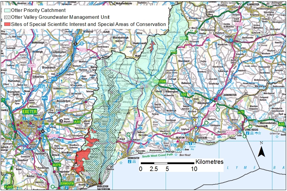
© Environment Agency copyright
Stakeholder and Partnership Groups
The following stakeholder and partnerships groups are active in the East Devon catchments, including the Otter priority catchment:
-
West Country Water Resources (WCWR).
-
South West Water Upstream Thinking
The WCWR is led by the water companies Bristol Water, South West Water and Wessex Water. It works at a strategic level across the whole of the West Country to develop a co-ordinated approach to water resource planning for the next 25 years. The Environment Agency is also a core member. We ensure that the Otter priority catchment work is aligned with WCWR Group strategic direction.
The EDCP is hosted by Devon Wildlife Trust and West Country Rivers Trust. It aims to deliver positive outcomes for the water environment through local collaboration. Recent projects have focussed on water quality and flood risk issues. There may be future opportunities to collaborate on water resource issues in the Otter priority catchment.
South West Water is leading a catchment management partnership called Upstream Thinking. It aims to enhance water quality and ecology by working with landowners and farmers across the West Country. Projects in the River Otter catchment have included:
-
improving soils
-
reducing nitrogen loss to groundwater
-
improving habitats for wildlife
Deterioration in groundwater quality could lead to a reduction in amount available for drinking water purposes and its use by river ecology.
In addition, the first meeting of the Otter Valley abstractor group took place in September 2021 as part of the priority catchment initiative. Attendees included water companies, landowners, quarry operators and other commercial and private abstractors. Abstraction is reducing flow in the River Otter to levels that are too low to support the expected ecology. We hope that the abstractor group will:
-
stimulate conversations between abstractors on their future water needs
-
help abstractors identify how these future water needs can be met sustainably
-
share understanding of water company actions that develop through the WINEP investigations and options appraisal (see section 4.1)
For more information on future events please contact the Devon and Cornwall Integrated Environmental Planning team using the details in section 9.
Otter Valley groundwater model
A computer model has been co-developed by the Environment Agency and South West Water. It represents how rainfall moves through soils, into aquifers and interacts with rivers in the Otter priority catchment. The model allows us to assess the current impact of abstractions on river flow and to test any future changes that may be proposed.
The model underpins all resource assessment work within the Otter priority catchment. It has allowed us to reduce abstraction licence volumes, design river augmentation schemes and assess the effects of climate change.
Groundwater Recharge and Working With Natural Processes
This new Environment Agency study provides evidence for the benefits of working with natural processes (WWNP). It focusses on improving resilience to droughts and floods by restoring natural catchment functions. Natural processes help to store water in the ground and slow down the rate at which it enters rivers.
In the River Otter catchment, WWNP has mapped potential interventions that could help improve water infiltration and groundwater availability:
-
installing attenuation features
-
improving soil and land management techniques
-
re-naturalising the channel
-
storing more water within the valley floors
The project produced a series of maps. These show where these actions are most likely to be effective. This is a valuable resource for water users considering holistic catchment-based solutions. The full report is available on the Environment Agency priority catchment website. The potential benefit of increased infiltration through WWNP processes are being evaluated using the Otter Valley groundwater model in 2022.
Investigating land use and water resource project
This Environment Agency project is assessing the effectiveness of trees to reduce surface water run-off and create infiltration pathways.
Monitoring equipment has been installed in the River Wolf and River Love catchments to analyse responses to rainfall events in 3 vegetation types:
-
fully wooded
-
rivers with wooded buffer strips
-
open managed grassland
The project has benefited from engagement with landowners on monitoring equipment and land use. The results should help inform future tree planting to maximise water resource benefits.
Project members include South West Water, Devon County Council and Natural England.
River Otter beaver trial
River Otter Beaver Trial was a 5-year project (2015 to 2020) to evaluate the effects of the reintroduction of Eurasian beavers into the wild. It has demonstrated that beaver engineering in the River Otter has had multiple benefits for:
-
flooding
-
ecology
-
water quality
-
slowing river flow
-
supporting low flow regimes
The beaver trial has shown that during storms peak flows are 30% lower leaving the site than entering. The slow release of this stored water maintains a higher downstream flow, over a longer period (even at times of low flow). Thus potentially allowing abstraction to continue.
Lower Otter Restoration Project
The Lower Otter Restoration Project (LORP) is an important project in the East Devon catchments. It seeks to pre-emptively adapt and enhance the downstream part of the River Otter in the face of a rapidly changing climate. This managed realignment scheme is being implemented because the existing 200-year-old sea defences are now starting to fail and are becoming increasingly hard to maintain.
Working with the landowner (Clinton Devon Estates) and the local community, we are reconnecting the River Otter to its historic floodplain. This will return the lower Otter Valley to a more natural condition by creating more than 50 hectares of intertidal mudflats and saltmarsh. Construction works started in Spring 2021 and will be completed by Spring 2023.
Once the project is complete the site will be inundated twice a day by saline water entering the lower Otter Valley floodplain. Modelling has shown this to have a neutral effect on the groundwater quality of existing abstractions. However, the changed saltwater inundation patterns will need to be considered when assessing future abstraction proposals in this area. As part of the scheme groundwater monitoring boreholes are being installed to monitor the potential impact of saline intrusion.
6. Related links
Agriculture and Horticulture Development Board (AHDB) website - provides information on effective use of water on livestock farms
Catchment Based Approach community website - provides further information on the catchment based approach
UK Centre for Ecology and Hydrology Drought Portal - is an interactive portal presenting information on the latest hydrological situation across the UK
Environment Agency, how to apply for a water abstraction or impoundment licence web pages - provide all the information needed to go through the application process to get a licence
Environment Agency manage your water abstraction or impoundment licence online web service - allows abstractors to view and share licence information and submit abstraction returns
Environment Agency priority catchments website - provides further information about the priority catchment work
Environment Agency National Framework for Water Resources - explores England’s long-term water needs and the importance of planning at the regional scale and link to the catchment scale
Linking Environment and Farming (LEAF) Simply Sustainable Water guide – explains 6 simple steps for managing water quality and industrial use
National Farmer’s Union web pages on Irrigation and water resources – provide useful information
Natural England’s website provides further information on protected sites and species
Environment Agency and Cranfield University’s guide to planning, designing, constructing and commissioning a water storage reservoir – if you are considering an irrigation reservoir
The UK Irrigation Association and Cranfield University - provide a range of irrigation booklets that tackle key issues
Waste and Resources Action Programme website has guidance on water efficiency in the food and drink industry
Waster and Resource Action Programme website has a guide to water saving devices and practices
7. Glossary
Abstraction - removal of water from a source of supply (surface or groundwater).
Abstraction licence - the authorisation granted by the Environment Agency to allow the removal of water.
Aquifer - a water-bearing geological unit that can yield economically viable amounts of groundwater.
Assessment point - a significant point on a river, often where 2 major rivers join or at a gauging station.
Baseflow - baseflow is the proportion of river flow derived from subsurface pathways, most notably groundwater. The baseflow component of river flow is delayed relative to rainfall runoff pathway and can therefore be important in sustaining rivers at times of low flow.
Catchment - the area from which precipitation and groundwater will collect and contribute to the flow of a specific river.
Catchment based approach - partnership working at the river catchment scale to deliver a range of environmental, social and economic benefits while protecting our precious water environments for the benefit of all.
Consumptive abstraction - abstraction where a significant proportion of the water is not returned either directly or indirectly to the source of supply after use. For example for the use of spray irrigation.
Common Standard Monitoring Guidance - Common Standards Monitoring was developed to provide an agreed approach for the assessment of conditions on protected sites designated through UK legislation and international agreements. The targets set as part of Common Standards Monitoring are the main conservation objectives for European and SSSI protected sites required to maintain them at, or to reach, favourable condition. These quantitative targets are considered by Natural England as a pre-requisite for achieving the conservation objectives for those important sites. The process for setting targets is described through the Joint Nature Conservation Committee (JNCC) approved Common Standards Monitoring Guidance or CSMG. The targets are set by Natural England and include river flow. The Environment Agency must have regard to Natural England’s advice when determining licence applications that may impact on a designated site.
Discharge - the release of substances (for example, water, treated sewage effluent) into surface waters.
Environmental flow indicator - the environmental flow indicator, or EFI, is a percentage deviation from the natural river flow that is required to support Good Ecological Status as defined by the Water Framework Directive. It is the proportion of the natural flow for a river that is allocated for the environment and is dependent on the sensitivity of the river to abstraction (and other impacts on flow). The EFI is set through expert opinion and is dependent on river type, river flow and the ecological sensitivity of the river to changes in flow. The EFI was set in line with new UK standards set by UK Technical Advisory Group (UK TAG).
Fully Licensed - the volume of surface water or groundwater abstracted if all authorised abstraction licences were being used to their full quantity.
Groundwater - water that is contained in underground rocks and sediments below the ground surface.
Groundwater Body - groundwater bodies are the discrete groundwater management unit defined by the Environment Agency as required under Article 5 of the Water Framework Directive.
Hands off flow - a condition attached to an abstraction licence which states that if flow (in the river) falls below the level specified on the licence, the abstractor will be required to reduce or stop the abstraction.
Impoundment - a structure that obstructs or impedes the flow of inland water, such as a dam, weir or other constructed works.
Non-consumptive abstraction - a groundwater or surface water abstraction where the water removed is returned to the source of supply at or near the point of abstraction without any significant loss of water.
Otter Sandstone - the Otter Sandstone is the historical name given to the most productive aquifer unit in East Devon catchments. This geological unit has been renamed the Helsby Sandstone Formation. The Helsby Sandstone Formation is commonly underlain by the Chester Formation which was historically known as the Budleigh Salterton Pebble Beds. The historical names for both these geological formations are still commonly used. Taken together, the Helsby Sandstone Formation and Chester Formation constitute the nationally important aquifer of the Sherwood Sandstone Group.
Recent actual - the amount of water actually abstracted by surface water or groundwater licenses on average over the previous 6-year period.
Surface water - this is a general term used to describe all water features such as rivers, streams, springs, ponds and lakes.
Water body - units of either surface water or groundwater which we use to assess water availability.
Water Framework Directive - the Water Framework Directive (2000/60/EC) is the key piece of legislation that introduced a comprehensive river basin management planning system to the UK to help protect and improve the ecological health of our rivers, lakes, estuaries and coasts and groundwater.
8. Copyright - maps
© Environment Agency copyright and/or database right 2022. All rights reserved. This map includes data supplied under licence from: © Crown Copyright and database right 2022. All rights reserved. Ordnance Survey licence number 100024198.
9. Contact details for further information
For local water resources advice contact the Devon, Cornwall and Isles of Scilly Integrated Environmental Planning Team.
-
call 03708 506 506 (calls cost no more than a national rate call to an 01 or 02 number)