Cam and Ely Ouse abstraction licensing strategy (ALS)
Published 22 December 2020
Applies to England

© Crown copyright 2020
This publication is licensed under the terms of the Open Government Licence v3.0 except where otherwise stated. To view this licence, visit nationalarchives.gov.uk/doc/open-government-licence/version/3 or write to the Information Policy Team, The National Archives, Kew, London TW9 4DU, or email: psi@nationalarchives.gov.uk.
Where we have identified any third party copyright information you will need to obtain permission from the copyright holders concerned.
This publication is available at https://www.gov.uk/government/publications/cam-and-ely-ouse-abstraction-licensing-strategy/cam-and-ely-ouse-abstraction-licensing-strategy
1. About the licensing strategy
1.1 Overview
This strategy sets out how we manage new and existing abstraction and impoundment within the Cam and Ely Ouse catchment in the Anglian river basin district.
It ensures that we:
- meet River Basin Management Plan (RBMP) objectives for water resources activities
- avoid deterioration within this catchment
We apply this approach to the water body in which the abstraction is located.
It also applies to:
- all downstream surface water bodies that may be affected by any reduction in abstraction related flow
- adjacent groundwater bodies affected by any reduction in groundwater level
The strategy also sets out local approaches to the sustainable management of water resources. This is in collaboration with partners.
Managing water abstraction describes the technical explanation, legal and policy requirements behind the Abstraction Licensing Strategy (ALS).
The abstraction pages advise on:
- who needs an abstraction or impoundment licence
- how to apply for a licence
1.2 How is the licensing strategy set out?
This ALS provides an overview of how water is sustainably managed in the Cam and Ely Ouse catchment to:
- provide water for abstraction
- protect the environment
The following is a summary of what each section covers:
Catchment background - sets out additional information about the catchment and the influences and pressures on water availability.
Water resource availability - explains how much water is available for abstraction in the catchment.
How we manage water resource availability - explains the local licensing approach for the catchment which is summarised in Table 2. This includes the potential water available for licensing and the restrictions that would be required.
Managing the catchment together - details the actions we are taking where abstraction is currently unsustainable in the catchment. Approaches to ensure sustainable water management in the future are outlined, including information on licence trading.
Related links - are listed for further information on water resource management.
Glossary - of useful terms.
Contact details - on how to get in touch.
Note: whilst our assessment tools are continuously updated, we aim to update this document on a 3-year basis. Therefore some details within this document, for example Hands off Flow (HoF) values, may be outdated. Use this publication as a guide to water availability. For up to date and detailed advice see the section contact details.
1.3 Collaborative and sustainable water management
Our long-term goal is to develop a stronger catchment focus for water resources management. We are working with abstractors and catchment groups to:
- develop local solutions to existing pressures
- prepare for the future
Catchment groups may include a variety of different partnership groups such as:
- abstractor groups
- local catchment partnerships
- priority catchment groups
- environmental groups
Since the autumn of 2018, we have been collaborating with local partners. In several priority catchments across England we have explored:
- modern and innovative ways of improving access to water
- alternative ways to achieving sustainable abstraction
The Cam and Ely Ouse catchment was selected as a priority catchment in the Defra water abstraction plan.
We assessed water resource availability using our standard approach. We then have worked with partners to:
- identify local opportunities to modernise abstraction management
- share resources sustainably both now and in the future
Background information on the priority catchment project is available in the catchment background section. Further details and links on approaches trialled in this catchment are provided in the managing the catchment together section.
This strategy provides a tool to make informed decisions on the choices abstractors make about their use of water. We want this strategy to help abstractors:
- plan their water use and become more resilient in the face of climate change
- explore the opportunities offered by the priority catchments
2. Catchment background
2.1 Catchment overview
Landscape and land use
The catchment covers an area of approximately 3,664 km2. It is characterised by:
- East Anglian Chalklands in the south
- Brecklands in the north
- South Level Fenland to the west
Land use is predominantly arable agriculture. There is a strong rural feel to much of the area.
- population: 659,000 (estimated from ONS 2019 mid-year local authority estimates)
- 2,099 farms covering 280,042 hectares of farm land (Defra farm statistics)
Land use statistics based upon LCM2019 © NERC (UKCEH) 2020:
| Land Use Type | Proportion of catchment (%) |
|---|---|
| Permanent grassland | 17.6% |
| Arable | 60.5% |
| Urban | 8.2% |
| Forested | 12.5% |
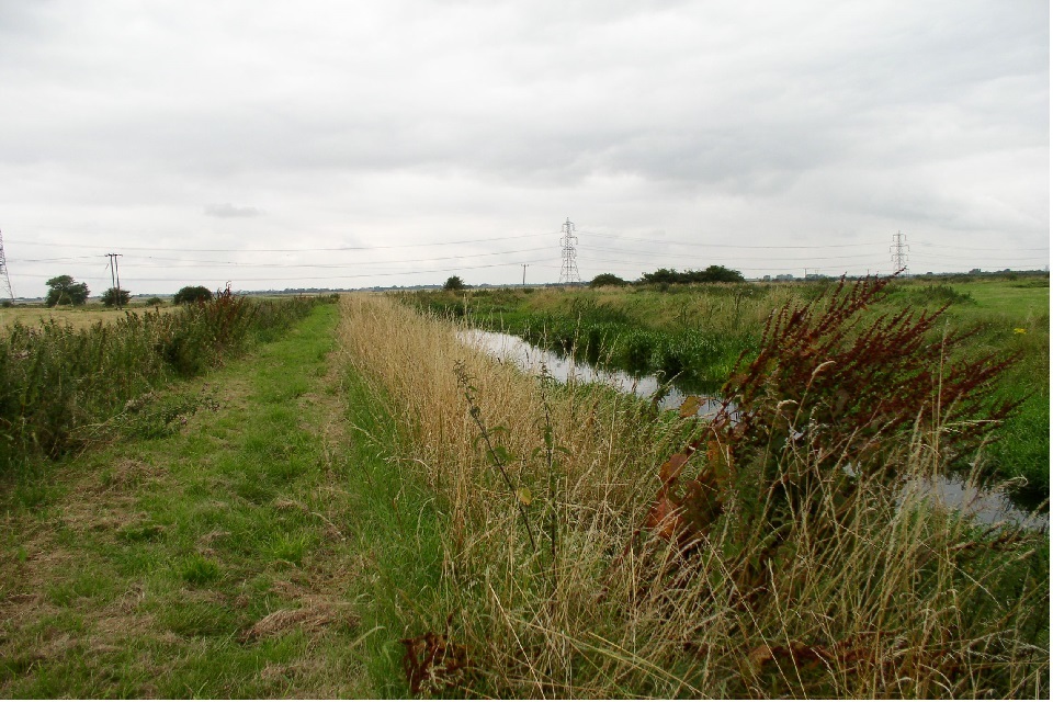
The photograph shows Soham lode, a typical high level drain in the Cam and Ely Ouse catchment.
Water resources
The catchment incorporates the following rivers and their tributaries:
- River Cam
- River Wissey
- Little Ouse
- River Lark
All drain to the Ely Ouse that discharges to tide at Denver. There is an extensive area of fenland (The South Level) which is level managed. Water levels are controlled using pumping stations to prevent flooding of land during wet periods. Water is transferred into the system during drier periods to facilitate crop production.
There are 2 important aquifers in this catchment:
- the larger Chalk underlies the eastern and central part of the area - it is mainly utilised for public water supply and spray irrigation
- the Lower Greensand outcrops further west and is separated from the chalk by a layer of gault clay
341 million m3
of water abstracted/year (based on 2013-18 average)
- 826 licensed abstractions
- 115 licences with Hands off Flow (HoF) restrictions at 26 gauging stations
- 79.9% of the catchment underlain by principal aquifer
Proportion of different sectors based on licensed abstraction quantity:
| Abstraction licence sector | Proportion of total licensed quantity (%) |
|---|---|
| Public water supply and other potable uses | 32% |
| Agriculture | 14.6% |
| Industry | 3.1% |
| Amenity/environmental | 50.2% |
Climate change
Climate change will impact on the quantity and seasonal availability of water resources within the catchment.
The projected climate change impacts on rainfall and river flow for the East Anglia region by the 2050s are for:
- rainfall to decrease by 39% in the summer but increase by 35% in the winter
- low flows to be 81% lower but peak river flows to be 35% higher
Climate change projections are estimated using data from UKCP09, consistent with a 4ºC rise by 2100. The Environment Agency Climate impacts tool provides further details on the assumptions used.
Environment and sustainability
The Cam and Ely Ouse ALS area has sites of both international and national importance. The Habitats Directive is a major European initiative that aims to protect biodiversity through the conservation of:
- natural habitats
- wild plants
- animals
Any abstraction we permit must not negatively impact on these sites. More information on protected sites and the implications for abstraction licensing is available in section 4.3.
We must also ensure that abstraction does not impact on the ecology of rivers and streams. Under the Water Framework Directive several of the Cam and Ely Ouse water bodies are not achieving good ecological status. Actions we are taking to reduce unsustainable abstraction are detailed in section 5.1.
167 designated protected areas (SACs, SPAs, SSSIs, LNRs and Ramsar)
Licence reductions:
- Restoring Sustainable Abstraction (RSA) programme: 18,433,006 m3/year
- unused and underused licence project: 333,957 m3/year
Water Framework Directive (WFD):
- 73 water bodies (includes 4 lake water bodies)
- 5% water bodies at good status or higher
- 35% water bodies where flow pressure does not support good status
2.2 The priority catchment initiative and partnership working
The Cam and Ely Ouse catchment was selected as a priority catchment in the Defra water abstraction plan.
Since the autumn of 2018, we have been working with water users and other partners exploring modern ways of managing water. We are working together across sectors including:
- public water supply
- agriculture
- environment
- flood risk management
- navigation
This delivers multi-functional outcomes which are good for:
- the environment
- people and business
Our focus was to bring together all water users. Together they:
- identified the challenges and pressures
- investigated how to improve the water situation
This catchment was chosen for a number of reasons including:
- current levels of abstraction may be negatively affecting the ecology
- there is unmet demand for water due to low rainfall and a large agricultural sector
- there is potential to share water amongst abstractors
- stakeholders who were keen to trial innovative approaches
With our stakeholders we have trialled different ways of managing water. These are covered in section 5.2. Some trials are finished and some are continuing with the support of our local catchment partnerships.
The Cam & Ely Ouse (CamEO) catchment partnership is active in this catchment which brings together stakeholders from a range of backgrounds to address issues in the catchment. There are also several water resources themed groups which feed into the partnership.
The CamEO partnership website has further information on:
- on-going activities in the Cam & Ely Ouse priority catchment
- how you can get involved
3. Water resource availability in the Cam and Ely Ouse catchment
3.1 Surface water availability
The method for calculating the water resource availability is explained in Managing water abstraction. Water availability is calculated at selected Assessment Points (APs). The maps show the water availability calculated at the AP, local water availability may differ. There are 17 APs in the Cam and Ely Ouse ALS:
- AP 1: the Old West River, which follows an old course of the River Great Ouse, from Earith to its confluence with the Cam near Streatham, there is little flow apart from what is pumped in from the adjacent fenland system - the AP is at the confluence with the Ely Ouse which is the boundary between the Old West Level Dependent Management Unit (LDMU) and the Ely Ouse LDMU
- AP2: the River Granta, a tributary of the River Cam - the AP is just upstream of the confluence with the River Cam
- AP3: the chalk fed Upper River Cam is highly responsive to the prevailing groundwater conditions - the AP is just upstream of the confluence with the River Granta
- AP 4: the River Rhee is predominantly groundwater fed from chalk springs in its headwaters, with significant contributions from run-off - the AP is located just upstream of the confluence with the River Cam
- AP5: the Bourn Brook is predominantly runoff fed with some groundwater contribution from chalk to the south and greensand covered by till to the west - the AP is just upstream of the confluence with the River Cam
- AP 6: the lower River Cam, upstream of the confluence with the Old West River (originally the Great Ouse) is predominantly fed by chalk groundwater, with contributions from the Greensand to the west - the AP is downstream of the Lodes LDMU
- AP7: the River Snail is predominantly groundwater fed from chalk - the AP is just before the river joins the Ely Ouse LDMU
- AP8: the River Kennet is predominantly groundwater fed from chalk
- AP9: the Upper River Lark is underlain by chalk which provides significant base flow for the river
- AP10: the lower River Lark is underlain by chalk which provides significant base flow for the river - the AP is after the confluence with the River Kennet and just before the river becomes a high level carrier within the Ely Ouse LDMU
- AP11: the River Sapiston is underlain by chalk which provides significant base flow for the river - the AP is just before the confluence with the Little Ouse at Rectory Bridge
- AP12: the upper Little Ouse is underlain by chalk which provides significant baseflow for the river - the AP is just before the confluence with the River Sapiston at County Bridge Euston
- AP13: the River Thet is underlain by chalk which provides significant baseflow for the river - the AP is just before the confluence with the Little Ouse at Melford Bridge
- AP14: the Little Ouse is underlain by chalk which provides significant baseflow for the river - the AP is just upstream of the Cut-Off Channel immediately before the Little Ouse becomes a high level carrier within the Ely Ouse LDMU
- AP15: the Upper River Wissey is underlain by chalk which provides significant baseflow for the river - the AP is at Northwold
- AP16: the River Wissey is underlain by chalk which provides significant baseflow for the river –the AP is just upstream of the Cut-Off Channel immediately before the Little Ouse becomes a high level carrier within the Ely Ouse LDMU
- AP 17: the Ely Ouse to Denver Sluice which is the critical AP for all sites in the Cam and Ely Ouse - between Denver Sluice and the upstream APs is the Ely Ouse Pond with the Ely Ouse and its tributaries acting as high level carriers within this LDMU, water is transferred to the Ely Ouse Pond during the summer and pumped out during the winter
The Cut-Off Channel runs from Tollgate on the Lark to Denver, going under the Little Ouse at Hockwold and the Wissey at Wissey Sluice. During high flows this acts as a flood relief channel with water diverted from the Lark, Little Ouse and Wissey into the Cut-Off Channel. Water is abstracted from the Cut-Off Channel at Blackdyke as part of the Ely Ouse Essex Transfer.
The major sources of this water are:
- the Diversion Sluice at Denver which can be used to transfer water from the Ely Ouse into the Cut-Off Channel
- seepage from the groundwater into the Cut-Off Channel
- water transferred from the Little Ouse at Hockwold as part of the Great Ouse Groundwater scheme see Section 4.5
Flows at Denver include:
- flows going into the tidal River Ouse from the Ely Ouse through the Little Eyes
- flow going into the Flood Relief Channel from the Ely Ouse through the Head Sluice
- flow going into the Flood Relief Channel from the Ely Ouse through the Residual Flow Sluice
- flow from the Cut-Off Channel into the Flood Relief Channel through the Impounding Sluice
Water resource availability colours and implications for licensing
We use colours to represent different surface water availability at a range of flows:
Water available for licensing
Green
There is more water than required to meet the needs of the environment.
New licences can be considered depending on local and downstream impacts.
Some time-limited licence renewals may require changes to reflect historic annual usage in order to manage the risk of deterioration to the environment.
Abstractions for non-consumptive uses can still be permissible in catchments where there are sustainability issues.
Restricted water available for licensing
Yellow
Licensed flows fall below the Environmental Flow Indicators (EFI) or there is no more water available for licensing at these flows.
If all licensed water is abstracted there will not be enough water left for the needs of the environment. In some catchments abstracting all licensed water would still support the needs of the environment, but there is no surplus left for new abstractions. No new consumptive licences would be granted. It is likely we’ll be taking action to reduce full licensed risks. Water may be available if you can ‘buy’ (known as licence trading) the entitlement to abstract water from an existing licence holder. More details on water rights trading are available in section 5.3.
Abstractions for non-consumptive uses can still be permissible in catchments where there are sustainability issues.
Water not available for licensing
Red
Recent actual flows are below the EFI.
This scenario highlights water bodies where flows are below the indicative flow requirement to help support a healthy ecology in our rivers. We call this ‘Good Ecological Status’ (GES) or ‘Good Ecological Potential’ (GEP) where a water body is heavily modified for reasons other than water resources.
Some time-limited licence renewals may require changes to reflect historic annual usage in order to manage the risk of deterioration to the environment.
Abstractions for non-consumptive uses can still be permissible in catchments where there are sustainability issues.
Note: we are currently taking action in water bodies that are not supporting GES or GEP. We will not grant further licences. Water may be available if you can buy (known as licence trading) the amount equivalent to recently abstracted from an existing licence holder.
Heavily Modified Water Bodies (HMWBs) and/or discharge rich water bodies
Grey
These water bodies have a modified flow that is influenced by reservoir compensation releases or they have flows that are augmented. These are often known as ‘regulated rivers’. They may be managed through an operating agreement, often held by a water company. The availability of water is dependent on these operating agreements. A large proportion of the watercourses within the catchment have been classified as Heavily modified waterbodies (HMWBs), under the Water Framework Directive. This is due to the presence of flow control structures such as sluices and gauges. More detail if applicable can be found in the section 4.1.
The water resource availability is calculated and the colour assigned at 4 different flows:
- Q30 - the flow of a river which is exceeded on average for 30% of the time, therefore you would expect the river flow to be lower than Q30 on 256 days in an average year, that is, a higher flow
- Q50 - the flow of a river which is exceeded on average 50% of the time, therefore you would expect the river flow to be lower than Q50 on 183 days in an average year
- Q70 - the flow of a river which is exceeded on average for 70% of the time, therefore you would expect the river flow to be lower than Q70 on 110 days in an average year
- Q95 - the flow of a river which is exceeded on average for 95% of the time, therefore you would expect the river flow to be lower than Q95 on 18 days in an average year, that is, a low flow
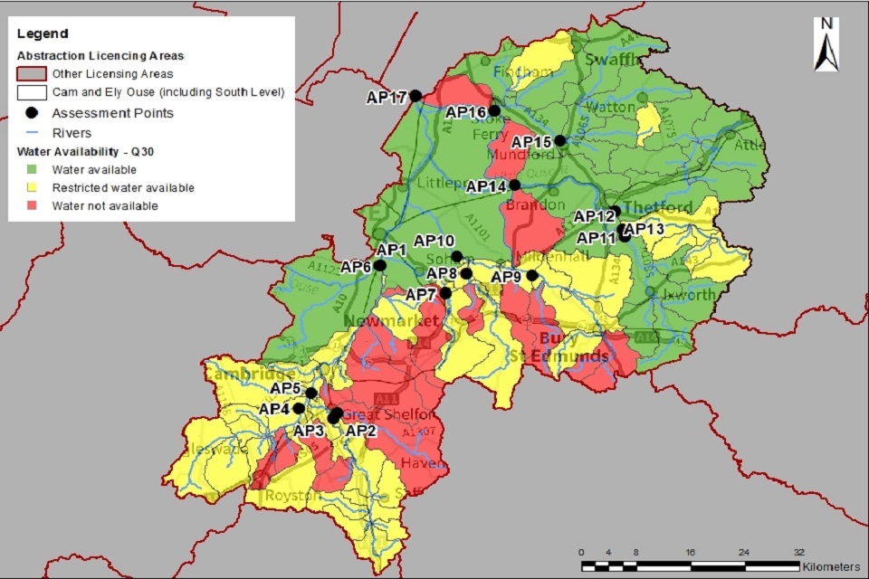
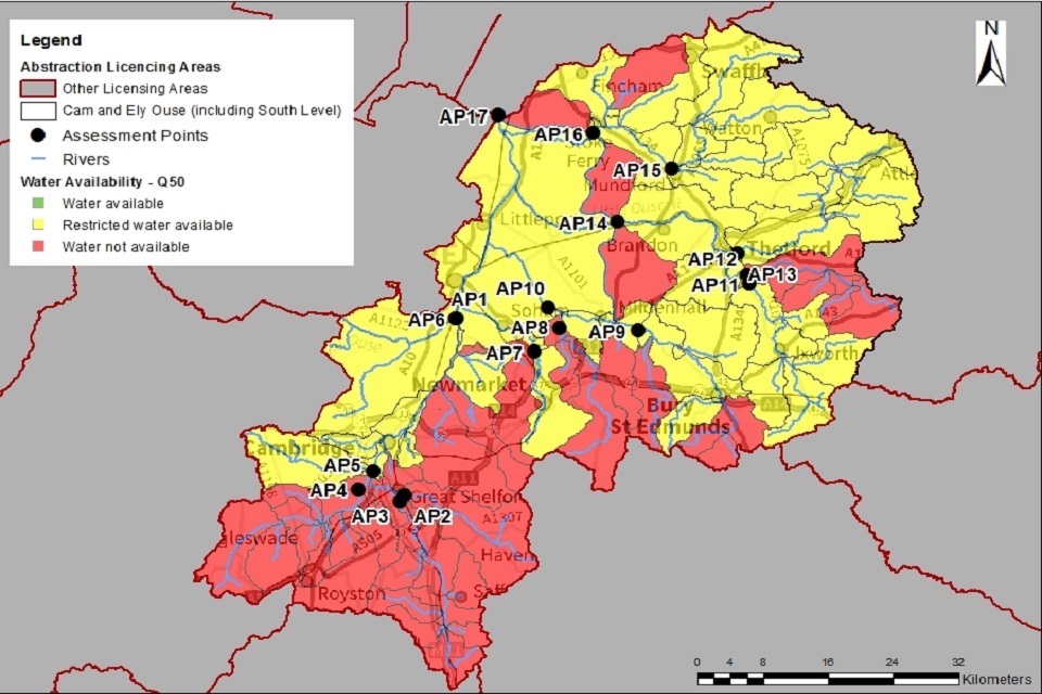
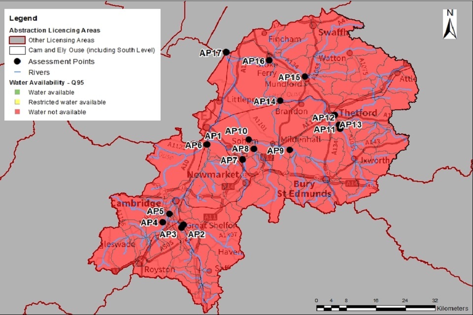
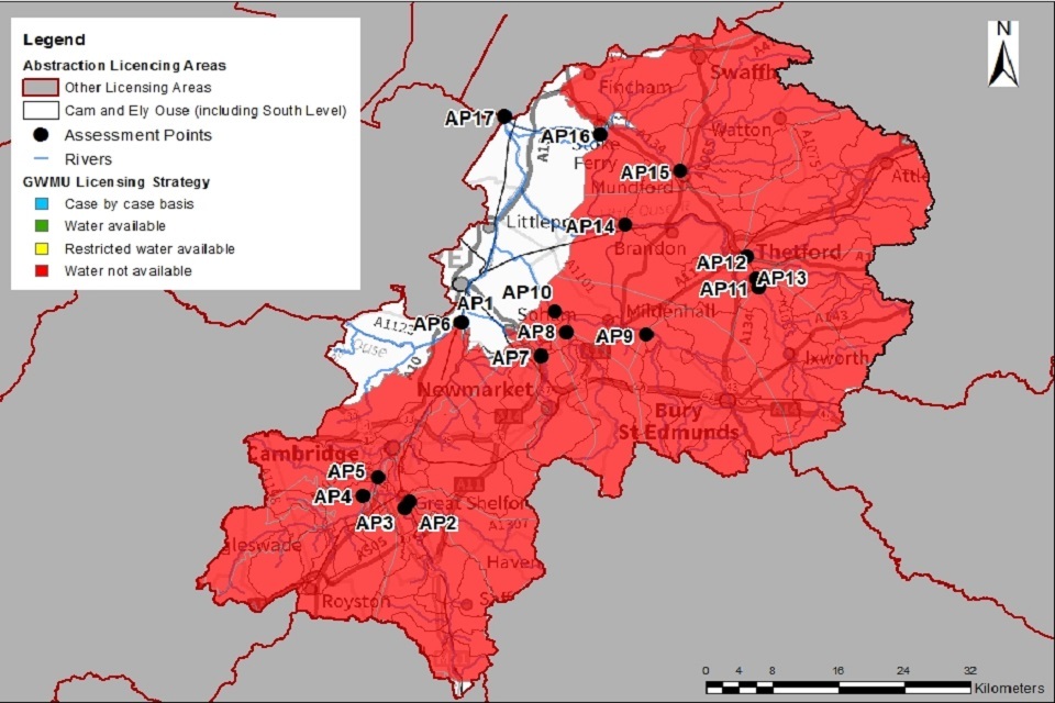
Water availability maps
The water availability colours for the Cam and Ely Ouse catchment are presented in Maps 1 to 4. Table 1 gives a summary of these maps. Note the water availability presented is based on assessment at the AP level. Refer to section 4 and Table 2 for more detailed information on water availability.
Table 1: Summary of Maps 1 to 4 - water availability at each assessment point by flow category
| Name | Q30 | Q50 | Q70 | Q95 | |
|---|---|---|---|---|---|
| AP1 | Old West | Available | Restricted | Not available | Not available |
| AP2 | River Granta and Chalk | Not available | Not available | Not available | Not available |
| AP3 | Upper River Granta and Chalk | Restricted | Not available | Not available | Not available |
| AP4 | River Rhee and Chalk | Not available | Not available | Not available | Not available |
| AP5 | Bourn Brook | Available | Restricted | Not available | Not available |
| AP6 | Lower River Cam and Chalk | Available | Restricted | Not available | Not available |
| AP7 | River Snail and Chalk | Restricted | Restricted | Not available | Not available |
| AP8 | River Kennett and Chalk | Restricted | Restricted | Not available | Not available |
| AP9 | Upper River Lark and Chalk | Restricted | Restricted | Not available | Not available |
| AP10 | Lower River Lark and Chalk | Restricted | Restricted | Not available | Not available |
| AP11 | River Sapiston and Chalk | Restricted | Restricted | Not available | Not available |
| AP12 | Upper Little Ouse and Chalk | Restricted | Restricted | Not available | Not available |
| AP13 | River Thet and Chalk | Restricted | Restricted | Not available | Not available |
| AP14 | Lower Little Ouse and Chalk | Restricted | Restricted | Not available | Not available |
| AP15 | Upper River Wissey and Chalk | Available | Restricted | Not available | Not available |
| AP16 | Lower River Wissey and Chalk | Available | Restricted | Not available | Not available |
| AP17 | Denver Sluice | Available | Restricted | Not available | Not available |
Our resource assessment system calculates water availability at the water body scale and translates to the larger (AP) availability. The maps in this section show the water body scale availability. Summaries within Table 1 and 2 present the overall water availability status at the (AP). Assessment at the water body scale will be considered for applications for new or varied licences.
Whilst Maps 1 to 4 may indicate that water is available at a catchment level this may not be the case locally. All proposals must be assessed on a case-by-case basis. We must take into account localised flows in the watercourse, and the impact of the proposed abstraction on designated sites and other abstractors. When considering applying for a new surface water abstraction applicants should take the following into account:
- we may consider the extension of the abstraction period of a winter licence into early summer - this may affect the subsistence charges associated with a licence
- a minimum Q95 (HoF) condition will apply to all new surface water abstractions
- the HoF required to protect surface water flows may be higher than indicated in Maps 1 to 4 and Table 1 and 2, based on the local assessment of a proposal
Map 1: Water resource availability colours at Q30 for Cam and Ely Ouse ALS
© Environment Agency copyright
Map 2: Water resource availability colours at Q50 for Cam and Ely Ouse ALS
© Environment Agency copyright
Map 3: Water resource availability colours at Q70 for Cam and Ely Ouse ALS

© Environment Agency copyright
Map 4: Water resource availability colours at Q95 for Cam and Ely Ouse ALS
© Environment Agency copyright
3.2 Groundwater resource availability
Water availability is guided by the surface water resource availability at low flows (Q95). This takes into account the impacts of groundwater abstraction on the surface water body. Where we have better information on principlal aquifers or are aware of local issues we need to protect, we will use this information. In certain areas, resource concerns over groundwater mean that the standard water resource availability colours have been overridden.
Groundwater resource availability colours and implications for licensing
We use colours to represent different groundwater availability at a range of flows:
Water available for licensing
Green
Groundwater unit balance shows groundwater available for licensing. New licences can be considered depending on impacts on other abstractors and on surface water.
Restricted water available for licensing
Yellow
Groundwater unit balance shows more water is licensed than the amount available. But the actual situation is sustainable because either:
- recent actual abstractions are lower than the amount available
- management options are in place to deal with known local impacts
In restricted groundwater units no new consumptive licences will be granted. We may also investigate the possibilities for reducing fully licensed risks. Water may be available if you can ‘buy’ (known as licence trading) the entitlement to abstract water from an existing licence holder. More details on water rights trading are available in section 5.3.
In other units there may be restrictions in some areas such as in relation to saline intrusion.
Water not available for licensing
Red
Groundwater unit balance shows more water has been abstracted based on recent amounts than the amount available.
We will not grant further licences.
3.3 Groundwater availability map
The groundwater availability map shows in this catchment that there is no water available for new consumptive abstraction across all groundwater units.
Map 5: Groundwater resource availability colours for the Cam and Ely Ouse ALS
© Environment Agency copyright
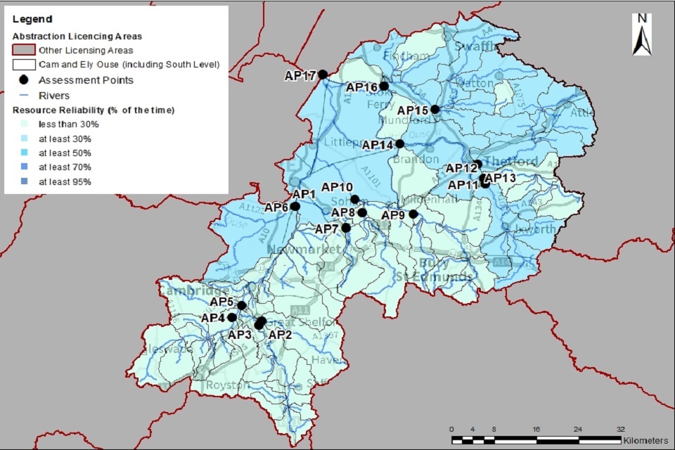
3.4 Resource reliability
If you want to apply for a licence, it’s worth considering the reliability of your surface water abstraction.
By assessing the quantity of water available at different flows it’s possible to see:
- when there is a surplus or deficit of water
- the associated reliability of an abstraction
This is an indication only. Actual reliability of a licence will be discussed when you apply.
Map 6 gives an indication of the resource availability for consumptive abstraction in the Cam and Ely Ouse area expressed as a percentage of time.
In this catchment consumptive abstraction is available:
- less than 30% of the time at APs 2, 3, 4, 7, 8, 9, 10,11, 12, 13 and 14 (pale blue on Map 6)
- at least 30% of the time at APs 1, 5, 6, 15, 16 and 17 (darker blue on Map 6)
Map 6: Water resource reliability of the Cam and Ely Ouse ALS expressed as percentage of time available
© Environment Agency copyright
3.5 Other considerations for resource availability and reliability
We may have to add constraints to licences such as hands off flow (HoF) conditions to protect:
- the environment
- the rights of other abstractors
As a result, when we grant a licence, it doesn’t mean that we guarantee a supply of water. These conditions specify that if the flow in the river or groundwater level drops below what’s needed to protect the environment, abstraction must reduce or stop. In dry years, restrictions are likely to apply more often. This will affect the reliability of supply.
In order to protect the valuable environmental effects of high flows in our rivers, we only normally consider issuing high flow (winter) abstraction licences. These should have a peak instantaneous rate (pump rate) of no more than 10% of the flow passing the abstraction point.
There is no guarantee that we will grant a licence, even where water is available for abstraction. This is because we have to determine each application on its own merits. Local factors may mean we’re either unable to grant a licence as applied for, or even at all.
New licences within a catchment are usually given a Common End Date (CED). This allows them to be reviewed at the same time. The next CED for this ALS is 31 March 2027 and the subsequent one is 31 March 2039.
More information on our approach to licence renewals and variations is available in section 5.1
3.6 Impoundments
Applications for impoundments will be dealt with on a case-by-case basis. More information may be found on our water management web pages.
4. How we manage water availability in the Cam and Ely Ouse ALS area
4.1 Surface water
We assess surface water flows at Assessment Points (APs). These are significant points on a river, often where 2 major rivers join or at a gauging station. APs cover multiple surface water bodies.
Where groundwater abstractions directly impact on surface water flows, we measure the impact at the surface water (AP). This occurs at all APs except AP1 and AP5. For AP8, parts of the River Kennett only flow:
- during the winter months
- in response to significant rainfall
- high groundwater levels
At AP17, the groundwater is limited to small areas of greensands with extremely limited resource availability.
Table 2 gives an indication of:
- how much water is available for further abstraction
- associated restrictions that may apply to new and varied abstraction licences from the main river
Depending on the nature of the catchment, tributaries to the main river may be subject to different restrictions and quantities. This may be assessed locally on a case-by-case basis.
Each HoF is linked to an AP and is dependent on the resource availability at that AP. In some cases additional restrictions may apply to licences where there is a more critical AP resource availability downstream. This is to protect the ecological requirements of the river and other water users. This is detailed in the last column of Table 2 if applicable.
All abstraction licence applications are subject to an assessment to take account of any local and downstream issues and may be subject to further restrictions.
Reading from top to bottom in Table 2 are the APs in the Cam and Ely Ouse ALS area. Reading across the columns you can see the:
- potential HoF that may be applied to a licence
- the number of days water may be available under this restriction
- the approximate volume of water in Ml/d that may be available
In cases where there is water available at all flows we may apply a Minimum Residual Flow (MRF) to protect very low flows. We’ll decide this on a case-by-case basis.
Table 2: Summary of licensing approach for the assessment points of Cam and Ely Ouse ALS
The information in this table is correct at the time of publishing but is subject to change.
| AP | Name | AP National Grid Reference | Water Resource Availability | HOF Restriction (Ml/d) | Number of days per annum abstraction may be available | Approximate volume available at restriction (Ml/d) | Is there a gauging station at this AP? | Additional restrictions |
|---|---|---|---|---|---|---|---|---|
| 1 | Old West | 553469 274576 | Water Available at Q33 (AP17 Denver) | 37 | 120 | 41.3 | No | Status reflects downstream critical AP17 – HoF set at Denver. Old West LDE level restrictions may apply. |
| 2 | River Granta and Chalk | 547182 251447 | Water Available at Q20 | 23 | 73 | 3.3 | Stapleford | |
| 3 | Upper River Granta and Chalk | 546582 250635 | Water Available at Q23 | 78.5 | 84 | 18.2 | Dernford | HoF may be gauged at Chesterford and will be a different volume. |
| 4 | River Rhee and Chalk | 541504 252317 | Water Available at Q22 | 96.2 | 80 | 20.9 | Burnt Mill | |
| 5 | Bourn Brook | 543310 254718 | Water Available at Q33 (AP17 Denver) | 15.8 | 120 | 18.0 | No | Level based cessation set at Fox’s Bridge or at point of abstraction. |
| 6 | Lower River Cam and Chalk | 553601 274506 | Water Available at Q33 (AP17 Denver) | 250.5 | 120 | 22.2 | No | Lodes LDE level based restrictions may apply. |
| 7 | River Snail and Chalk | 563096 270242 | Water Available at Q8 | 46.3 | 29 | 12.6 | Fordham | |
| 8 | River Kennett and Chalk | 566231 273313 | Water Available at Q19 (AP10 Lower River Lark) | 30.3 | 69 | 16.0 | Beck Bridge | Hands off Flow or Level based cessation condition set at Beck Bridge or at point of abstraction. |
| 9 | Upper River Lark and Chalk | 575799 272593 | Water Available at Q19 (AP10 Lower River Lark) | 130.6 | 69 | 23.7 | Temple | HoF may be gauged at Fornham and will be a different volume. |
| 10 | Lower River Lark and Chalk | 564882 276041 | Water Available at Q19 | 146.7 | 69 | 46.5 | No | |
| 11 | River Sapiston and Chalk | 589536 279092 | Water Available at Q22 (AP14 Lower Little Ouse) | 73 | 80 | 37.9 | Euston Rectory | Status reflects downstream critical AP17 |
| 12 | Upper Little Ouse and Chalk | 589179 280178 | Water Available at Q18 | 38.9 | 66 | 0.8 | County Bridge Euston | |
| 13 | River Thet and Chalk | 587984 283020 | Water Available at Q20 | 182.9 | 73 | 28.7 | Melford | Status reflects downstream critical AP17. HoF may be gauged at Bridgham or Redbridge and will be a different volume. |
| 14 | Lower Little Ouse and Chalk | 573321 287106 | Water Available at Q22 | 380.6 | 80 | 84.4 | No | Status reflects downstream critical AP17. HoF set at Denver or can be set at Abbey Heath for certain parts of the river. |
| 15 | Upper River Wissey and Chalk | 580011 294122 | Water Available at Q33 (AP17 Denver) | 168.3 | 120 | 40.9 | Northwold | Status reflects downstream critical AP17 |
| 16 | Lower River Wissey and Chalk | 570307 299047 | Water Available at Q33 (AP17 Denver) | 282.9 | 120 | 54.3 | No | Status reflects downstream critical AP17. HoF may be set at Denver or at Whitebridge gauging station for certain parts of the river. |
| 17 | Denver Sluice | 558877 300947 | Water Available at Q33 | 1040.3 | 120 | 121.1 | Denver Sluice | South Level LDE, level based restrictions may apply. |
The Environment Agency undertook detailed flow and ecology monitoring in water bodies identified under WFD. This is where it was shown that actual flows were more than 50% less than the modelled EFI target flow. In some water bodies where the relationship between flow and ecology data was statistically significant, we have identified a bespoke or target flow needed for that particular water body to protect the ecology. This is shown in Table 3.
Table 3: Bespoke flow targets
| Location | AP | Flow restriction | National Grid Reference |
|---|---|---|---|
| River Granta | 2 | 26 l/s at Babraham gauging station | TL51039 50394 |
| River Cam | 3 | 195 l/s at Great Chesterford gauging station | TL50520 42632 |
| River Cam | 3 | 249 l/s at Dernford gauging station | TL46707 50664 |
| Ashwell Springs | 4 | 23.15 l/s at Ashwell gauging station | TL26645 40048 |
| Hobson’s Brook at Ninewells Local Nature Reserve | 6 | 20 l/s at Ninewells Local Nature Reserve | TL46067 54127 |
| River Lark | 9 | 91 l/s at Fornham St Martin gauging station | TL84768 67226 |
| River Little Ouse | 9 | 94 l/s at Euston County Bridge gauging station | TL89558 79049 |
Note: these are alternative flow targets so would apply instead of adding an EFI Q95 HoF on an existing unconstrained licence.
4.2 Groundwater
For major aquifers we may divide the area into groundwater management units (GWMU). These are sub-divisions of the groundwater bodies. We use the information and assessments on these units to determine:
- water availability
- licence restrictions
Where groundwater abstractions directly impact on surface water flows the impact is measured at the surface water AP. This includes where the impact reduces baseflow. In these cases, restrictions may be applied to licences, such as Hands off Level (HoL) conditions. The HoL is a groundwater level below which an abstractor is required to reduce or stop abstraction.
This is the case for abstractions from unconfined groundwater sources. In confined sources, the impact of the abstraction is measured at the surface water AP where the rock outcrops. The interaction between the groundwater and the surface water occurs over a long timescale. This means the impact of groundwater abstraction does not occur at the time of abstraction. So there is only one groundwater status regardless of season or river flow. We take the water resource status at the low flows (Q95) as the groundwater status to ensure protection of the river environment when it is most vulnerable.
Licence restrictions on groundwater abstractions in the Cam and Ely Ouse ALS area
There are localised areas of sand and gravel (secondary aquifer) in the area. Where these overlie principle aquifers the licensing policy for the underlying principle aquifer GWMU will apply. Where these lie within areas classed as ‘unproductive strata’ they will be treated on a case-by-case basis. They are more likely to follow the surface water strategy for the catchment subject to local conditions and impacts. Table 4 sets out the groundwater management units and restrictions in the Cam and Ely Ouse catchment.
Table 4 Groundwater managment units and restrictions in Cam and Ely Ouse
| Groundwater Management Units | Restrictions for groundwater abstractions |
|---|---|
| GWMU 1 – Chalk | No Water Available - for new consumptive abstractions |
| GWMU 2 – Greensands | No Water Available - for new consumptive abstractions |
| GWMU 3 – Unproductive including localised Sands and Gravels | No Water Available - for new consumptive abstractions |
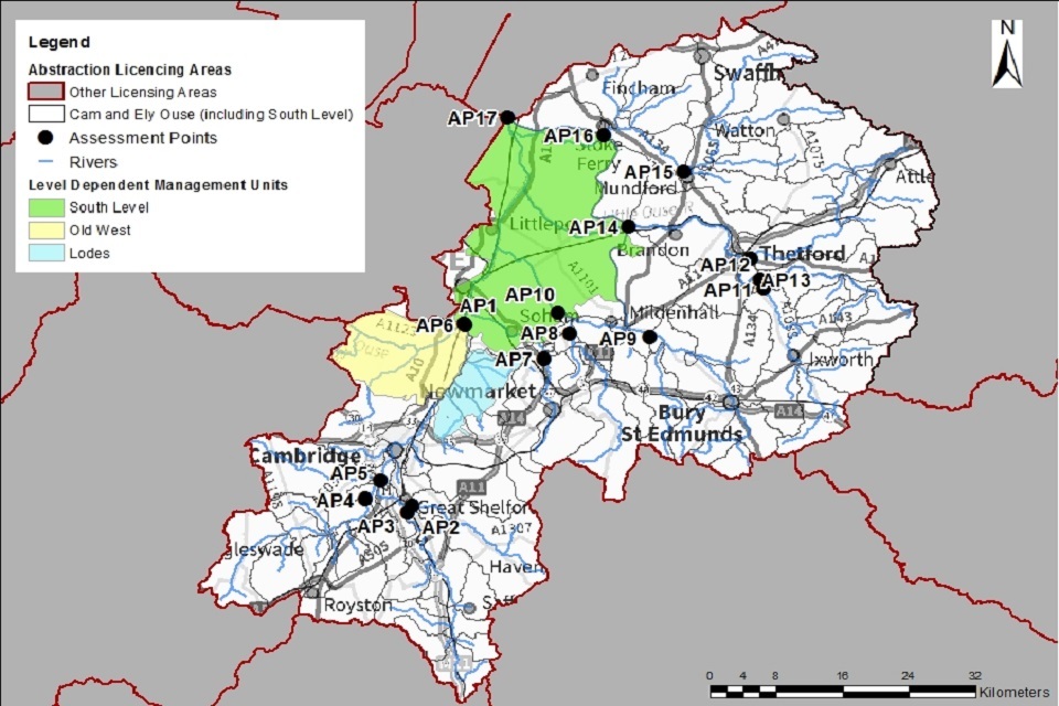
4.3 Level dependent environments
The Cam and Ely Ouse ALS contains level dependent environments (LDE).
Level dependent environments are characterised by a network of river channels flowing above the level of the surrounding land. Internal Drainage Boards (IDBs) manage the water levels in the LDEs. They pump out water into the main rivers in the winter months (when levels are high). During the summer months, when there are periods of high demand for water, it is drawn in to top up levels. Most of the land in the LDE is intensively managed for agriculture. Demand for water is for spray irrigation in summer months.
Within the Cam and Ely Ouse ALS area the level dependent fenland is called the South Level.
We have divided the area into units, known as level dependent management units (LDMU). We have completed an assessment on each of these units.
The Old West LDMU
The Old West LDMU is an area of Fenland sourced by the Old West River. Five IDBs manage the LDMU:
- Caudle Fen IDB
- Waterbeach Level IDB
- Old West IDB
- Haddenham Level IDB
- Willingham and Over IDB
Each IDB manages low level drains through pumping regimes at several pumping stations.
The Lodes LDMU
The Lodes LDMU is made up of the Swaffham IDB area and some additional land including Wicken Fen SSSI/SAC. The Lodes intersect the LDMU forming several distinct catchments which all drain to one pumping station at Upware.
The Ely Ouse LDMU
The Ely Ouse LDMU covers the main area of the South Level. The main river is the Ely Ouse River. There are also tributaries contributing water to the low level system. From south to north, these are:
- Soham Lode
- River Lark
- Little Ouse River
- River Wissey
- Cut-Off Channel
The Denver Complex effectively ponds the Ely Ouse and its tributaries and controls the outflow of water from the LDMU. Various IDBs manage the drainage in the LDMU.
Licence restrictions on abstractions in the relation to LDEs in the Cam and Ely Ouse ALS area
The South Level is complex because there are various sources for the water, and policy may vary depending on the source. In general, water is sourced from:
- the rivers
- spring flow
- the Cut-Off Channel
In some places, the Hundred Foot River is the water source rather than the Ely Ouse system. This affects the cessation conditions that are applied.
LDM unit 1: Old West coloured yellow in map 7
No water available at low flows.
Water may be available at high flows subject to a Hands Off Flow (HoF) condition at AP17 (Denver Sluice).
LDM unit 2: Lodes coloured blue in map 7
No water available at low flows.
Water may be available at high flows subject to a Hands Off Flow (HoF) condition at AP6 (Lower River Cam and Chalk).
LDM unit 3: Ely Ouse coloured green in map 7
No water available at low flows.
Water may be available at high flows subject to a HoF condition at AP17 (Denver Sluice).
For all 3 LDMUs:
We may include a local level based cessation condition to protect Internal Drainage Board (IDB) drain levels. It may be possible to allow additional pumping when the HoF is enforced if the IDB are pumping water out (subject to IDB agreement).
Trading of recent actual quantities within IDB areas may be possible. We will consider proposals on a case-by-case basis in consultation with the relevant IDB.
Map 7: Level dependent environments in the Cam and Ely Ouse ALS
© Environment Agency copyright
4.4 Heavily modified water bodies
Most watercourses within the catchment are classified under the Water Framework Directive as Heavily Modified Water Bodies (HMWBs). This is due to the presence of flow control structures such as sluices and gauges. You can find more information in our River Basin Management Plan.
Several of the rivers are designated as HMWBs due to the presence of river support schemes. Groundwater support schemes support these rivers:
- River Granta
- Lodes
- River Thet
- River Little Ouse
4.5 Supported Rivers
The Ely Ouse to Essex transfer Scheme (EOETS) and The Great Ouse Groundwater Scheme (GOGS)
The EOETS was developed to augment flows in Essex rivers for subsequent transfer into public water supply reservoirs. There are 2 main elements:
- a transfer of water to Essex
- the provision of groundwater to supplement the transfers via GOGS
Under EOETS water is:
- diverted at Denver from the Ely Ouse River into the Cut-Off Channel
- pumped through a series of pipelines into Essex
The transfer at Denver is limited by a minimum flow requirement to the Tidal Ouse.
GOGS was developed with the EOETS to pump water into the Little Ouse and Thet Rivers for transfer into the Cut-Off Channel and then to Essex. It was developed to provide water when there is insufficient water in the Ely Ouse to meet the demands of water users and the environment in Essex, particularly in drought years.
Flow from GOGS discharges in the Thet and Little Ouse. It is of benefit to licence holders who abstract from supported reaches of these rivers. Abstractors who are supported by GOGS pay a premium rate for their licence. Usually the demand for water from Essex and local abstractors coincides.
But, this is not always the case. So, there is an agreement that a proportion of the GOGS water will be pumped when not required by EOETS. This supports the Thet and Little Ouse abstractors when flows are too low to meet their needs.
The Lodes Granta Support Scheme
The Lodes Granta scheme comprises of 6 boreholes that discharge at 10 points to support the Lodes and the River Granta. The scheme mitigates the effects of abstraction in the catchment during dry periods. It is not designed to mitigate against drought when these watercourses would naturally dry up.
The Rhee Groundwater Support Scheme
The Rhee scheme comprises of 8 boreholes that support 8 tributaries of the River Rhee. This includes 3 SSSIs:
- Ashwell Springs
- Fowlmere Watercress Beds
- Thriplow Meadows
Some of the tributaries are supported every year, others in times of drought.
Other River Support
Some watercourses are supported by public water supply companies. Affinity Water support the River Cam and Ashwell Springs in consultation with the Environment Agency. They use a proportion of their abstraction allowance to mitigate the impact of their licences on the river and spring.
4.6 Protected areas
The Conservation of Habitats and Species Regulations 2017 (Habitats Regulations) provides a very high level of protection to 2 types of designated sites due to their special environment. These are:
- Special Areas of Conservation (SAC), which contribute to biodiversity by maintaining and restoring habitats and species
- Special Protection Area (SPA), which provides protection to birds and their nests, eggs and habitats
As a matter of government policy Ramsar sites, internationally important wetland sites, are treated in the same way as SACs and SPAs. Ramsars, SACs and SPAs are referred to collectively as European sites. Sites of Special Scientific Interest (SSSI) also carry a high level of environmental importance.
Across the catchment there are 4 SACs and 120 SSSIs of which 57 are water dependent. The only SPA in the catchment is Breckland SPA. Abstraction licences within or near to these areas may be subject to additional measures to protect the species and habitats of each protected area.
Conservation objectives are the overarching objectives for European and SSSI protected sites to maintain or reach favourable condition. These are set by Natural England. The conservation objectives may consist of qualitative and quantitative descriptions. The process for setting targets that underpin the objectives, is described through JNCC approved ‘Common Standards Monitoring Guidance’ (CSMG). These targets are used by Natural England in assessing the condition of European and SSSI protected sites. These quantitative targets are considered by Natural England as a pre-requisite for achieving the conservation objectives for European or SSSI designated sites.
Projects and Plans
The Wicken Fen Vision plans to create a new nature reserve covering 53 square kilometres between Cambridge and Wicken Fen. Cambridge and Wicken Fen is a SSSI and component of Fenland SAC. The National Trust own and manage it. The plan is to create:
- a mosaic of different habitats for wildlife
- a variety of open spaces for people to enjoy including wetland habitat and areas of open water
For more information see the Wicken Fen Vision website.
5. Managing the catchment together
5.1 Action on unsustainable abstraction
Managing water abstraction gives details on:
- what an unsustainable abstraction is
- the measures available to resolve environmental issues caused by abstraction
We have taken a number of actions to:
- reduce abstraction
- achieve objectives in this catchment
There are a series of other actions that we are taking to address unsustainable abstraction. These include:
Revoking or reducing unused and underused licences
We are contacting abstractors who have not used their licence or have only used a small portion of their licensed volumes. We are asking if they still require the water and for what purpose. Abstractors need to supply justification for retaining their licence, such as evidence of future use, contractual agreements to supply water or planning permission. We can revoke licences or reduce volumes where there is not sufficient evidence of need. The next phase of this project is due to begin December 2020 and will focus on licence holders previously contacted regarding lack of use or unused licences.
Water Industry National Environment Programme (WINEP)
We are working with Water Companies to investigate and address the impact of their abstractions on the environment. The WINEP identifies the actions required. Water companies are implementing changes through the Asset Management Plan (AMP) 6/7 process. For example:
- river restoration
- capping of licences
- river augmentation
Managing time limited licence renewals
We are managing time limited licence renewals to ensure abstraction is not having a negative impact on the environment now or in the future. There is more information on our renewal policy later in this section.
Managing licence variations
We are managing licence variations to ensure abstraction is not having a negative impact on the environment now or in the future. There is more information on our groundwater licence variation policy later in this section.
Water efficiency measures
We encourage forward planning and water efficiency measures to prepare for peak demand periods. At times of limited resource we engage with spray irrigators and encourage them to use water as efficiently as possible. We also promote night time irrigation whenever possible to reduce evaporative losses.
Voluntary restrictions
We use voluntary restrictions to reduce demand and prevent or delay formal licence restrictions.
Storage reservoirs
We support and encourage licencing for storage reservoirs which are filled by winter high flows when water is available.
Water Rights Trading and Aggregation policy
We have adapted our water rights trading and aggregation policy. This is to ensure we prevent deterioration in the status of water bodies. There is more information on our water rights trading policy in section 5.3.
Priority catchment collaboration
Through the priority catchment we have been working with abstractors to highlight unsustainable abstraction. We are encouraging stakeholders to collaborate to find innovative ways to access water sustainably. There is more information on the priority catchment trials in section 5.2.
Managing renewals/variations of licences
We have, and will continue, to change surface and groundwater licences by reviewing time limited licences.
We will adjust licence quantities as necessary if:
- abstraction quantities are no longer justified
- renewal may pose a risk of deterioration in ecological status
This may be by capping of licence quantities when they have come up for renewal as part of the renewal process.
Surface water
Licence renewals will be on the following broad principles around environmental sustainability.
As a minimum, all surface water licences will need a HoF to protect the ecological needs of a river at low flows. We define low flows as the Q95, which is the amount of flow in a river that is exceeded 95% of the time. To calculate the amount of water required to support the ecology of a river at low flows we use a tool called the Environmental Flow Indicator (EFI).
We will renew an application on same terms, subject to it having a HoF condition that protects low flows. We will renew to the relevant common end date. There must be no other sustainability issues in the surface water bodies influenced by the abstraction. The applicant must justify the quantities and demonstrate that the water is being used efficiently.
We will time-limit renewed licences to 31 March 2024 in surface water bodies where a low flow HoF doesn’t resolve all of the sustainability issues in the catchment. We may need to make further changes after 2024 to protect the ecology at higher flows.
Groundwater
Licences will be renewed on the following broad principles around environmental sustainability.
We will consider renewing the licence at the same quantities. This is if the requirements of the following can be met:
- the aquifer
- overlying rivers
- associated wetland habitats
These must be met at current levels of abstraction and if all licensed water is abstracted.
We will reduce the licensed quantities if there is a risk that abstracting all the licensed water could impact on the ecology. The 2015 RBMP classifications of water body status are based on the level of annual average abstraction during 2007 to 2012. If average abstraction increases above this baseline level the status of water bodies may deteriorate. We cannot allow this. To reduce the risk of deterioration we are taking a risk-based approach. In the first instance we will reduce licensed volumes to the annual maximum quantity abstracted between 2005 and 2015. The period for spray irrigation purposes is the years 2000 to 2015. This reflects the annual differences in climate and cropping patterns for this abstraction purpose.
In some water bodies capping abstraction to the historic annual maximum volume may not be enough. This is because abstraction was already unsustainable in 2015. We may need to make further changes to licences to restore abstraction to sustainable levels, this could include additional volume reductions. Licences are being renewed until 31 March 2024 in water bodies where we are investigating what measures are required to restore abstraction to sustainable levels.
We will consider renewal of time limited licence with regard to:
- environmental sustainability
- justification of need
- efficient use of water
We must ensure that the licensing of abstraction:
- is sustainable
- won’t cause deterioration in the ecology of our rivers, wetlands and estuaries
- won’t deplete groundwater resources
Trading and aggregation
If unconstrained, water rights trading could result in a rise in annual average abstraction increasing the risk of deterioration in water body status. Section 5.3 gives more information on our approach to trading in Cam and Ely Ouse.
Aggregation could also result in deterioration. It will involve similar restrictions as water rights trading. Aggregation could include:
- adding a new point of abstraction to the licence (subject to local assessment)
- adding an additional purpose to a licence
- combining multiple licences
To reduce the risk of deterioration from proposals to aggregate licences we will take the following measures:
Temporary single year aggregations:
- the annual volume of each individual licence will be reduced to the maximum annual volume abstracted between 2005 and 2015 or 2000-2015 for spray irrigation purposes
- this annual volume will then be increased by the annual average volume abstracted by the “partner” licence between 2007 and 2012
- the annual volume that the 2 licences can abstract in combination will be limited to the combined maximum volume abstracted by the 2 licences in any year between 2005 and 2015 or 2000-2015 for spray irrigation purposes
Permanent aggregations:
- the annual volume of each individual licence will be reduced to the average annual volume abstracted between 2007 and 2012
- these historic average volumes are combined and applied to both licences to give the new maximum annual quantity for each licence
- the annual volume that the 2 licences can abstract in combination will be limited to the combined historic average volumes
Our full policy gives further details on our approach to water rights trading and aggregation in Cam and Ely Ouse. View this on the Environment Agency priority catchments website.
5.2 Approaches to sustainable water management
We have undertaken a range of catchment focused initiatives. These have formed part of the Cam and Ely Ouse priority catchment project. Project summaries outline trials of future approaches to water management. Trials initiated in this catchment have taken a collaborative approach. These may be of interest to both new and existing abstractors.
Water Abstraction Alert (WAA) - Digital Transformation
This trial aimed to improve access to water for existing abstractors. We worked in collaboration with the IDBs and National Farmers Union (NFU) to share WAAs in real time. WAAs were sent to the mobile phone numbers of participating abstractors. The trial ran in the Cambridgeshire Fenland Middle and South levels. It lasted over 2 abstraction seasons. Participants’ feedback was that the service was excellent and worked well. WAAs made it easier to know when to abstract. Defra is exploring a wider roll out of WAA. For more information on the WAA contact the East Anglia - West Integrated Environmental Planning (IEP) Team.
Water Sharing & Aggregation of licences
This project investigated water sharing options for the Lark Abstractors Group (LAG). Funding came from a Rivers Trust grant to the River Lark Catchment Partnership. It focussed on a group of 12 existing abstractors.
The project conducted technical investigations and hydrological modelling. Investigators based this on abstraction data and interviews. Cranfield University Water Science Institute (CWSI) carried out the study.
CWSI worked with the NFU and LAG to assess potential for water sharing based on:
- models
- spatial data
- connectivity of existing infrastructure (reservoirs) in the catchment
Project partners are scoping out further trials for the 2021 irrigation season. These will build on the findings of the study. For more information visit the Cam and Ely Ouse catchment partnership website.
Groundwater recharge and working with natural processes (WWNP)
This new study provides evidence for the benefits of working with natural processes. It focusses on improving resilience to drought and floods. Natural processes help to store water in the ground and slow down the rate at which it enters river systems.
In the Cam & Ely Ouse, the study focused on the Brecklands. This is an area characterised by heavy woodland cover. Results identified that vegetation density can have a strong influence on water budgets. Dense woodland can limit the proportion of water made available for recharging groundwater. The study proposes a reduction in woodland coverage and reversion to heath. This would significantly reduce the water budget deficit for the area. The maps show where these actions are most likely to be effective. Further details are available in the project report on the priority catchment webpage.
Understanding the sustainability of abstraction licences
Abstraction is having a negative impact on many of our rivers and groundwater bodies. This includes the principle chalk groundwater aquifer. We are working in partnership with:
- Cam & Ely Ouse Partnership hosts
- National Rivers Trust
The project will develop a series of maps. The maps will show where we may need to reduce licence volumes to protect the environment. Find more information on the Cam and Ely Ouse catchment partnership website.
Water Resource Advisory Farm Visits
We are collaborating with partners to trial water resources visits. Our partners include:
- National Farmers Union (NFU)
- Norfolk Rivers Trust
- Natural England’s Catchment Sensitive Farming programme
More than 40 farms in the Cam & Ely Ouse and 3 other priority catchments are part of the trial. The advice visits will help farmers to improve their water resource management systems. Visits are being conducted across various farm-types and sizes of operation.
The project reports will:
- identify areas of water resources efficiency
- share best practice
- offer potential solutions/interventions for farmers to make better use of available water
The NFU will deliver workshops to share best practice with other farmers. This will include lessons learnt on water efficiency.
Communications and engagement will remain important for management of water resources. Future work should continue to raise awareness amongst water users. A continuation of stakeholder led trials is also needed.
The priority catchment initiative has also been running elsewhere in England. More information on work in these catchments can be found in the updated ALS for the:
5.3 Water rights trading
We want to make it easier to trade water rights. A water rights trade is where a person sells all or part of their water right, as defined by their abstraction licence(s), to another person on a permanent or temporary basis. In the majority of cases a trade will involve a change in abstraction location and/or use which we will need to approve through the issue or variation of abstraction licences.
In licensing trades, as with new abstraction licences, we need to make sure that we don’t cause any deterioration in water body status.
This is both:
- within the water body / bodies where the trade will take place
- to downstream water bodies
This section provides a guide to the potential for trading in water bodies of a particular (ALS) water resource availability colour, as shown on Maps 1 to 4.
Guide to the potential trading in water bodies of a particular ALS water resource availability colour
Green
There may be opportunities to allow trades of recent actual abstraction and licensed abstraction. But little demand for trading expected within water body as water available for new abstractions.
Restricted water available for licensing
Yellow
There may be opportunities for licence holders to trade up to their full licensed quantities. But the quantities of water available to trade may be restricted once levels of actual abstraction reach sustainable limits. We will not permit licence trades in water bodies where we are taking action to prevent deterioration unless the trade is consistent with achieving water body objectives.
Water not available for licensing
Red
We will only trade recent actual abstraction but no increase in recent actual abstraction is permitted in water body. Licensed abstraction will be recovered for the environment.
HMWBs
Grey
Opportunities for trading will depend on local operating agreements and local management.
To find out more about licence trading go to our water management web pages on gov.uk.
We have recently developed a new trading policy for the whole of the East Anglia Area which includes the Cam and Ely Ouse catchment. In licensing trades we need to make sure that we don’t cause any deterioration in water body status. We will consider trades that meet the general criteria outlined below. We will assess each trading proposal on a case-by-case basis and further restrictions may apply.
The full trading policy can be:
- viewed on the Environment Agency priority catchment website
- viewed on the Cam and Ely Ouse Catchment Partnership website
- requested contacting the East Anglia - West Integrated Environmental Planning (IEP) Team
Surface water trades
The donor (seller) and recipient (buyer) licences should be abstracting from the same watercourse.
The donor and recipient licences should have the same abstraction period:
- we will not consider applications to move abstraction to the summer period
- we may consider extension of abstraction periods on a case-by-case basis
- we will consider applications to trade summer water to winter
- traded water should be used for the same purpose - we may need to adjust the volume of water that can be traded if the trade involves a change in purpose
- we will usually limit the volume of water available for trade to the average annual volume abstracted by the donor licence during 2007 and 2012
Groundwater trades
The donor and recipient licence need to abstract from the same aquifer and have comparable effects on surface water features. As a general rule, abstractions should be located in the same surface water body.
In general, the donor and recipient licences should have the same abstraction season:
- we are unlikely to consider moving summer abstraction to winter
- we may consider extension of abstraction periods on a case-by-case basis
Traded water should be used for the same purpose. The volume of water being traded may need adjusting if the trade involves a change in purpose.
If the trading proposal includes an increase in rates of abstraction we may need a pumping test to be undertaken.
We will usually limit the volume of water available for trade to the average annual volume abstracted by the donor licence during 2007 and 2012.
We will reduce the volumes available for abstraction on the donor licence for the duration of the trade.
This will reduce the risk of deterioration:
- for temporary trades of a single year: we will cap the annual volumes on the donor licence to the annual maximum volume abstracted by the donor licence between 2005 and 2015, minus the traded volume - for spray irrigation purposes the annual maximum volume will be based on abstraction between 2000 and 2015
- for recurrent trades or trades that are greater than one year in duration: we will cap the donor licence to the annual average volume abstracted by the donor licence between 2007 and 2012, minus the traded volume
- for permanent licence trades: we will permanently reduce the annual volumes on the donor licence to the annual average volume abstracted between 2007 and 2012, minus the traded volumes - if all of the 2007-12 recent actual quantity was traded, then the donor licence would cease to exist
We are currently developing new initatives to support trading in this catchment. These include:
- help for trading water rights map: helps abstractors to identify potential trades - it provides information on nearby licences and an indication of the potential for a trade
- temporary seasonal trades trial: is designed to help abstractors trade water over a single irrigation season - abstractors apply for these trades during a defined ‘trading window’ during the spring, after the publication of the initial irrigation prospects report
6. Related links
-
Agriculture and Horticulture Development Board (AHDB) website - provides information on effective use of water on livestock farms
-
Catchment Based Approach community website - provides further information on the catchment based approach
-
UK Centre for Ecology and Hydrology Drought Portal - is an interactive portal presenting information on the laterst hydrological situation across the UK
-
Environment Agency, how to apply for a water abstraction or impoundment licence web pages - provide all the information needed to go through the application process to get a licence
-
Environment Agency manage your water abstraction or impoundment licence online web service - allows abstractors to view and share licence information and submit abstraction returns
-
Environment Agency priority catchments website - provides further information about the Priority Catchment work
-
The Environment Agency National Framework for Water Resources explores England’s long-term water needs and the importance of planning at the regional scale and link to the catchment scale
-
The charity Linking Environment and Farming (LEAF) Simply Sustainable Water guide - explains 6 simple steps for managing water quality and industrial use
-
National Farmer’s Union web pages on Irrigation and water resources - provide useful information
-
Natural England’s website - provides further information on protected sites and species
-
Environment Agency and Cranfield University’s guide to planning, designing, constructing and commissioning a water storage reservoir - if you are considering an irrigation reservoir
-
The UK Irrigation Association and Cranfield University - provide a range of irrigation booklets that tackle key issues
-
Waste and Resources Action Programme website has guidance on water efficiency in the food and drink industry
-
Waste and Resources Action Programme website has a guide to water saving devices and practices
7. Glossary
Abstraction - removal of water from a source of supply (surface or groundwater).
Abstraction licence - the authorisation granted by the Environment Agency to allow the removal of water.
Assessment point - a significant point on a river, often where two major rivers join or at a gauging station.
Catchment - the area from which precipitation and groundwater will collect and contribute to the flow of a specific river.
Catchment based approach - partnership working at the river catchment scale to deliver a range of environmental, social and economic benefits while protecting our precious water environments for the benefit of all.
Consumptive abstraction - abstraction where a significant proportion of the water is not returned either directly or indirectly to the source of supply after use. For example for the use of spray irrigation.
Discharge - the release of substances (for example, water, treated sewage effluent) into surface waters.
Environmental flow indicator - flow indicator to prevent environmental deterioration of rivers, set in line with new UK standards set by UKTAG.
Groundwater - water that is contained in underground rocks.
Hands off flow - a condition attached to an abstraction licence which states that if flow (in the river) falls below the level specified on the licence, the abstractor will be required to reduce or stop the abstraction.
Impoundment - a structure that obstructs or impedes the flow of inland water, such as a dam, weir or other constructed works.
Surface water - this is a general term used to describe all water features such as rivers, streams, springs, ponds and lakes.
Water body - units of either surface water or groundwater which we use to assess water availability.
8. Copyright - maps
© Environment Agency copyright and/or database right 2020. All rights reserved. This map includes data supplied under licence from: © Crown Copyright and database right 2020. All rights reserved. Ordnance Survey licence number 100024198.
9. Contact details for further information
For local water resources advice contact the East Anglia - West Integrated Environmental Planning (IEP) Team. You can either call or email the team:
- call 03708 506 506 (calls cost no more than a national rate call to an 01 or 02 number)
- email enquiries@environment-agency.gov.uk