Alt Crossens abstraction licensing strategy
Published 30 June 2022
Applies to England

© Crown copyright 2022
This publication is licensed under the terms of the Open Government Licence v3.0 except where otherwise stated. To view this licence, visit nationalarchives.gov.uk/doc/open-government-licence/version/3 or write to the Information Policy Team, The National Archives, Kew, London TW9 4DU, or email: psi@nationalarchives.gov.uk.
Where we have identified any third party copyright information you will need to obtain permission from the copyright holders concerned.
This publication is available at https://www.gov.uk/government/publications/alt-crossens-abstraction-licensing-strategy/alt-crossens-abstraction-licensing-strategy
1. About the licensing strategy
1.1 Overview
This strategy sets out how we manage new and existing abstraction and impoundment within the Alt Crossens catchment in the North West .
It ensures that we:
-
meet River Basin Management Plan (RBMP) objectives for water resources activities
-
avoid deterioration within this catchment
We apply this approach to the water body in which the abstraction is located.
It also applies to:
-
all downstream surface water bodies that may be affected by any reduction in abstraction related flow
-
adjacent groundwater bodies affected by any reduction in groundwater level
The strategy also sets out local approaches to the sustainable management of water resources in collaboration with partners.
Managing water abstraction describes the technical explanation, legal and policy requirements behind the abstraction licensing strategies (ALS).
The abstraction pages advise on:
-
who needs an abstraction or impoundment licence
-
how to apply for a licence
1.2 How is the licensing strategy set out?
This ALS provides an overview of how water is sustainably managed in the Alt Crossens catchment to:
-
provide water for abstraction
-
protect the environment
The following is a summary of what each section covers:
Catchment overview - sets out additional information about the catchment and the influences and pressures on water availability.
Water resource availability - explains how much water is available for abstraction in the catchment.
How we manage water resource availability - explains the local licensing approach for the catchment which is summarised in table 3. This includes the potential water available for licensing and the restrictions that would be required.
Managing the catchment together - details the actions we are taking where abstraction is currently unsustainable in the catchment. Approaches to ensure sustainable water management in the future are outlined, including information on licence trading.
Related links - are listed for further information on water resource management.
Glossary – explains technical terms included throughout this document.
Contact details – on how to get in touch.
Note: whilst our assessment tools are continuously updated, we aim to update this document on a 3 year basis. Therefore some details within this document, for example hands off flow (HoF) values may be outdated. Use this document as a guide to water availability. For up to date advice see the contact us section.
1.3 Collaborative and sustainable water management
Our long term goal is to manage catchments so that there is sufficient water for people and the environment in the face of climate change. To help address this we need a stronger collaborative focus for water resources. We are working with abstractors and catchment groups to:
- develop local solutions to existing pressures
- prepare for the future
Catchment groups may include a variety of different partnership groups such as:
- abstractor groups
- local catchment partnerships
- environmental groups
In several priority catchments across England we have explored:
- modern and innovative ways of improving access to water
- alternative ways to achieving sustainable abstraction
The Alt Crossens catchment was selected as a priority catchment in the Defra water abstraction plan. This plan sets out how the government will reform the way we manage water abstraction, to protect the environment and improve access to water.
In the Alt catchment we assessed water resource availability using our standard approach. The Crossens catchment is unique as it is almost entirely level dependent with no major flowing rivers. This means we are developing an alternative approach to define resource availability. We have worked with partners to identify and trial local opportunities to modernise abstraction management.
Background information on the priority catchment project is available in section 2, catchment overview. Further details and links on approaches trialled in this catchment are provided in section 5, managing the catchment together.
This strategy will help abstractors make informed decisions about their use of water. We want this strategy to help abstractors to better understand the local water resource situation. This will help them to plan their water use and become more resilient in the face of climate change.
As water availability changes over time, we will need to evolve our strategy. The strategy reflects how we currently manage water resources alongside more forward looking regional plans and the Water Resources National Framework.
We will adapt our approach to reflect changing water availability by:
- updating the natural flow data used in assessing water availability to reflect a shifting baseline - we are currently extending the period of record from 1990 to 2007 to 1990 to 2020 and plan to continue to update this 30 year period going forwards
- continuing to use our existing and future regulatory powers to ensure sustainability - as we move into the Environmental Permitting Regime, the permit review process will regularly evaluate the sustainability of abstraction permits at a catchment level
2. Catchment overview
The Alt Crossens catchment is an area of low-lying land between the Mersey and Ribble Estuaries. Approximately 30% of the catchment is made up of urban areas, including:
- North Liverpool
- Formby and Southport along the coast
- Kirkby, Maghull and Ormskirk inland
A large area of the catchment is high grade farmland which is crossed by a series of heavily modified watercourses and drains.
Prior to the development of the complex drainage system, a large part of the catchment used to form an inland lake. This lake was drained in order to realise the agricultural potential of the good quality peat soils within the catchment.
The hydrology of the area is complex because much of the catchment is at or below sea level. This means that heavy reliance is placed upon the Environment Agency’s 2 main pumping stations at Altmouth and Crossens. These remove water from the 2 catchments into Liverpool Bay.
The Environment Agency maintain water levels in the catchments taking into account various priorities, including:
- flood risk management
- water for irrigation of crops
- the environment
The Permo-Triassic Sandstones make up the main groundwater aquifers around North Merseyside and West Lancashire in the Alt Crossens catchment. These support public water supply as well as agricultural abstraction. There are also some locally important secondary aquifers within the catchment such as the Blown Sands on the Lancashire coast.
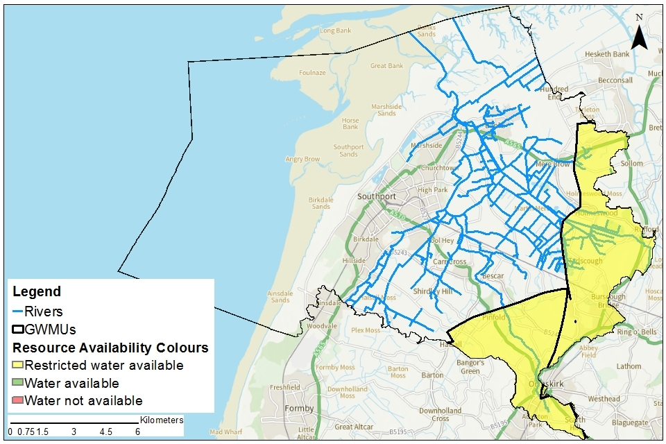
Map 1 shows the main rivers and drains and the location of our pumping stations. Altmouth and Crossens pumping stations are shown as they pump the water from the catchment out to the sea. The map also shows the locations of the assessment points in the Alt catchment.
Map 1: Alt Crossens catchment
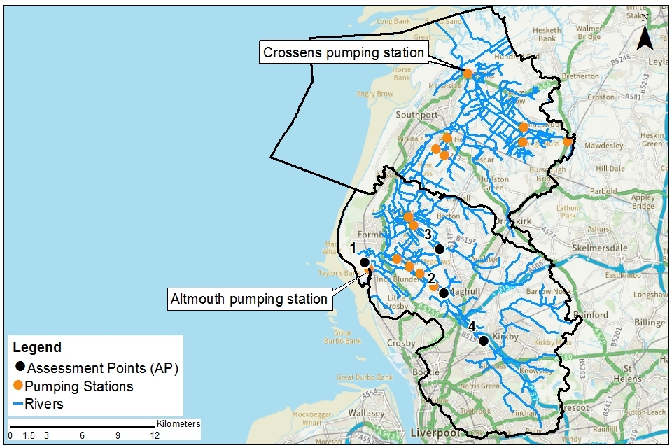
© Environment Agency copyright
Further information can be found via Magic map and catchment data explorer.
2.1 Landscape and land use
The catchment covers an area of approximately 260 km2. The upper Alt has heavily urbanised areas and the lower Alt and Crossens has high grade farmland.
The key urban areas within the catchment are the:
- north east quadrant of the City of Liverpool
- the coastal towns of Formby and Southport
Further inland are the populated areas of Ormskirk, Maghull and Kirkby. In the lower lying farmland areas, land reclamation has resulted in an extensive and complex system of artificial drainage ditches across the catchment.
In the upper Alt land use is mixed. In the lower Alt and Crossens arable agriculture is the dominant land use. The managed wetland at Martin Mere is a key tourist destination forming part of a growing focus on water based tourism in the area.
- population: 450,000 (estimated from ONS 2019 mid-year local authority estimates)
- 311 farms covering 20,751 hectares of farm land (Defra farm statistics)
Land use statistics based upon LCM2019 © NERC (UKCEH) 2020:
Land use type proportion of catchment (%)
| Land use type | Proportion of catchment (%) |
|---|---|
| Permanent grassland | 7% |
| Arable | 50% |
| Urban | 30% |
| Forested | 5% |
| Other | 8% |
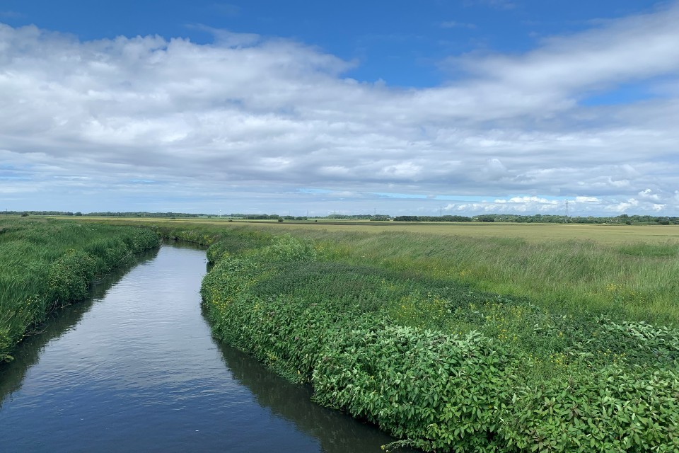
The photograph shows the River Alt at Shorwicks Bridge, Lunt looking northwards. The watercourse is perched within floodbanks above the lower lying agricultural land. The image shows the banks covered in Himalayan Balsam. Unfortunately it successfully outcompetes most native vegetation once established.
2.2 Water resources
Whilst there are flowing rivers in Alt Crossens, the hydrology is dominated by the need to manage water levels by pumping. Within the low lying areas the system acts like a short term reservoir storing recent rainfall in the soils and the channels. During winter months we pump water stored in the ditches out to mitigate flood risk. Conversely in the summer months, we keep water levels higher to preserve water resources for irrigation of the agricultural crops grown in the area and to protect the peat from shrinking.
The River Alt begins in Huyton and follows the M57 until the outskirts of Maghull. It then flows across low-lying farmland to its estuary in Hightown, a journey of approximately 30 miles. Throughout the whole catchment many of the water bodies are heavily modified. The land of the Alt catchment is generally very low lying. The Environment Agency manage river levels though the operation of the pumping station at Altmouth. Water is pumped out to sea as gravity drainage only occurs during low tide at Altmouth.
There are also 5 satellite pumping stations which pump water from the very low-lying areas up to the the main drain level. These are:
-
Ince Blundell
-
Hey Cop
-
Altcar
-
New Cut
-
Fine Jane
The Crossens catchment drains a low-lying area between Ormskirk and the edge of the Ribble Estuary near Banks, taking in the Sefton Coast and Southport. There is no capacity for gravity drainage from the Crossens catchment. This means that all water has to be pumped out to sea.
Since 1961 water has been pumped out by the Crossens pumping station located at Banks. This serves an area of approximately 130 km2 by draining water from 4 main tributary channels:
-
The Sluice
-
Three Pools
-
Back Drain
-
Middle Drain
The high level Sluice catchment drains the northern most area of land, the majority of which is high grade agricultural land. The largest settlement is Burscough Bridge. Tributaries include:
-
Tarleton Runner
-
Langleys Brook
-
Boathouse Sluice, which runs through Martin Mere WWT site
The low level Back Drain and Middle Drain system drains mainly high grade agricultural land.
The high level Three Pools watercourse has several tributaries including:
-
Fine Janes Brook draining the south east of Southport
-
Boundary Brook draining high grade agricultural land
-
Sandy Brook, also draining the agricultural land however this is one of the semi-natural tributaries in the catchment
There are also 6 satellite pumping stations which pump water from the very low-lying areas up to the main drain level. These are:
-
Boundary
-
Causeway
-
Clay Brow
-
Homeswood
-
Kew
-
Rufford
The Environment Agency’s Banks Marsh pumping station also removes water from a smaller area to the north of the Crossens catchment into the sea via the Ribble Estuary.
The lower sections of the Leeds Liverpool Canal include the Rufford Branch and the Ribble Link canal. These provide a link for navigation between Yorkshire to the east and the Lancaster Canal to the north. There are no canal feeders taking water from natural watercourses into the canal to support levels for navigation in these catchments. Some water is taken out of the canal for spray irrigation of crops.
There are sources of groundwater (aquifers) across the Alt Crossens catchment. The geology of the catchments is dominated by the Permo-Triassic Sandstone and Mercia Mudstones, with overlying superficial deposits.
The Permo-Triassic Sandstone is a principal aquifer and provides groundwater for:
-
public water supply
-
agriculture
-
commercial use in the urban areas in the south
The sandstone will also provide baseflow to some of the overlying rivers, predominantly the Alt.
Other minor aquifers in the catchments are the sand and gravels that overlie the sandstone and mudstones. These are mainly along the coast, but also further inland.
-
248 licensed abstractions (73 Alt and 175 Crossens)
-
82 licences with hands off flow (HoF) restrictions measured locally (22 Alt and 60 Crossens)
-
92 licences with hands off level (HoL) restrictions at 5 pumping stations and 7 locations within the LDE (4 Alt and 88 Crossens)
-
22% of the Crossens catchment underlain by principal aquifer
-
69% of the Alt catchment underlain by principal aquifer
Proportion of different sectors’ abstraction based on licensed abstraction quantity:
| Abstraction licence sector | Proportion of total licensed quantity (%) surface and groundwater combined | Proportion of total licensed quantity (%), groundwater only | Proportion of total licensed quantity (%) surface and groundwater combined | Proportion of total licensed quantity (%), groundwater only |
|---|---|---|---|---|
| - | Alt | Alt | Crossens | Crossens |
| Public water supply and other potable uses | 91% | 91% | 38% | 38% |
| Agriculture | 6% | 2% | 30% | 2% |
| Industry | 3% | 3% | 4% | 4% |
| Amenity/environmental | 0% | 0% | 28% | 0% |
| Power generation | 0% | 0% | 0% | 0% |
2.3 Climate change
Climate change will impact on the quantity and seasonal availability of water resources within the catchment.
The projected climate change impacts on rainfall and river flow for the North West region by the 2050s are for:
-
rainfall to decrease by 38% in the summer but increase by 29% in the winter
-
low flows to be 69% lower but peak river flows to be 35% higher
Climate change projections are estimated using data from UKCP09, consistent with a 4ºC rise by 2100. Further details on the assumptions used can be found in the Environment Agency Climate impacts tool.
2.4 Environment and sustainability
There are a number of areas within the Alt Crossens catchment that have statutory protected status due to:
-
wildlife habitats
-
landscape quality
-
unique geomorphology
These sites range from coastal intertidal zones classed as Special Protection Areas (SPAs), down to individual field size sites, for example Downholland Moss. Some sites have overlapping complementary designations. In addition to Statutory International designations, environment protection is also provided by UK law to National Nature Reserves. These commonly cover the same areas as those which have an international designation. Local authorities are also empowered to make local designations following discussion with recognised conservation bodies such as the Wildlife Trusts or Natural England; the agency dedicated to nature conservation and stewardship. Examples of local designations include:
-
Local Nature Reserves
-
County Biological Heritage Sites
-
Local Geodiversity Sites
Much of the peatland on Alt Crossens is locally designated, for example:
- Martin Mere Mosslands
- Halsall and Plex Mosses
- Altcar Withins
- Ince Blundell
Our licensing approach for the Alt Crossens catchment ensures that we avoid deterioration within this catchment in line with the Water Framework Directive (WFD). The WFD seeks environmental objectives to protect and enhance the water environment. It ensures the sustainable use of water resources for economic and social development.
Water body WFD status can be:
-
bad
-
poor
-
moderate
-
good
-
high
14 designated statutory protected areas (SACs, SSSIs, Ramsars and LNRs)
Water Framework Directive:
-
11 water bodies
-
no water bodies at good status or higher
-
11 water bodies at moderate status
-
no water bodies where flow pressure does not support good status
We assess the impacts of new water abstraction applications to make sure that they comply with the WFD. This includes ensuring water bodies will maintain a healthy ecology. If the ecology is not good, we ensure abstraction will not deteriorate the ecology further. WFD status is assessed at a water body scale.
Many of the water bodies are heavily modified and are under pressure from both urban and rural diffuse pollution. In the south of the catchment there are pollution impacts from:
-
sewage discharges
-
mis-connections
-
industry
-
transport
In the north of the area agricultural run-off is a major source of pollution. The overall WFD status of the water bodies in the Alt are moderate.
Groundwater body status is assessed with a separate set of tests under the WFD. The status is reported as either good or poor:
-
Lower Mersey Basin and North Merseyside Permo-Triassic Sandstone aquifers are at poor status
-
Rufford Permo-Triassic Sandstone aquifers are at good
-
West Lancashire Quarternary sand and gravel aquifers are at good status
As part of the government’s Water Abstraction Plan, we have written to licence holders who have not been using their licences and to those who have used only small amounts. We want to encourage them to either revoke or reduce their licences. This is to prevent increased abstraction creating new pressures. This has lead to 3 licences in Alt Crossens being revoked and a saving of 22,637m3 per year of water. We will continue to work with licence holders to further reduce unused and under-used licences.
Peat is a key resource in Alt Crossens with shrinkage a major concern. We are working with others to find and deliver the solutions needed.
2.5 Partnership working
The Alt Crossens catchment was selected as a priority catchment in the Defra water abstraction plan. Since 2019, we have been working with water users and other partners exploring modern ways of managing water. We are working together across sectors including:
-
public water supply
-
agriculture
-
environment
-
flood risk management
-
navigation and recreation
This will deliver multi-functional outcomes which are good for:
-
the environment
-
people and business
This catchment was selected as a priority catchment for a number of reasons including:
-
the opportunity to explore sustainable abstraction at a catchment scale
-
the opportunity to review the water availability and licences in Crossens
-
to review the balance between flood management and abstractors
-
the need for improved resilience to dry weather events
-
to identify opportunities to modernise abstraction management
-
to trial/test best practice irrigation techniques
-
a need to review existing licences to see if they allow abstraction whilst protecting the environment
The Alt Crossens catchment partnership is active in this catchment and hosted by Mersey Rivers Trust. They bring together stakeholders from a range of backgrounds to address issues in the catchment. Their Alt Crossens Catchment Plan focusses on considerate and cooperative water management. The aim is that this will support a healthy water environment, rich in wildlife that supports economic growth, health and wellbeing.
In addition there are also several water resources themed groups and activities which feed into the Catchment Based Approach (CaBA) partnership, such as:
-
Water Friendly Farming group
-
irrigation demonstration farm
Further details are given in section 5 about partnership working to investigate changes in peat levels and preserve and or restore it within the catchment.
3. Water resource availability in the Alt Crossens catchment
3.1 Surface water availability
Alt
The method for calculating the water resource availability in the Alt catchment is explained in Managing water abstraction. Water availability is calculated at selected assessment points (AP). The maps show the water availability calculated at the AP, local water availability may differ. There are 4 APs in the Alt catchment:
-
AP1: Alt at Altmouth, at the lower end of the Alt near the pumping station at Hightown
-
AP2: Alt at Maghull, upstream of Altmouth
-
AP3: Sudell Brook, upstream of Altmouth on a tributary originating north of Maghull
-
AP4: Alt at Kirkby, upstream of Maghill where river flow is more conventional
There are 2 level dependent management units (LDMU) in the Alt catchment:
-
LDMU 1: Black Drain
-
LDMU 2: Banks Marsh
Crossens
The Crossens catchment is unique amongst other catchments, in that it is almost entirely level dependent. The catchment contains no major flowing rivers upon which to base the assessment of water resources available for abstraction. We are not able to apply the standard assessment point approach, as used in the Alt catchment, to define resource availability. We are currently developing a new approach to defining surface water availability in the Crossens.
The Crossens catchment area contains 10 LDMUs:
-
Back Drain
-
Banks Marsh
-
Boundary
-
Clay Brow
-
Holmeswood
-
Kew
-
Middle Drain
-
Rufford Causeway
-
The Sluice
-
Three Pools
There are some small areas of land outside the LDMUs but within the Crossens catchment. We will do further investigations to review whether they stay within the Crossens catchment or move to another. In this document, these are referred to as Crossens non-LDMU areas.
Water resource availability colours and implications for licensing in the Alt
Water available for licensing
Green
There is more water than required to meet the needs of the environment. New licences can be considered depending on local and downstream impacts.
Note: we are currently taking action in water bodies that are not supporting GES or GEP. We will not grant further licences. Water may be available if you can buy (known as licence trading) the amount equivalent to recently abstracted from an existing licence holder.
Restricted water available for licensing
Yellow
If all licensed water is abstracted there will not be enough water left for the needs of the environment. No new consumptive licences would be granted. It is likely we’ll be taking action to reduce full licensed risks. Water may be available if you can ‘buy’ (known as licence trading) the entitlement to abstract water from an existing licence holder. Water may be available for licensing during the winter months when pumping is in operation.
Water not available for licensing
Red
This scenario highlights water bodies where flows are below the indicative flow requirement to help support a healthy ecology in our rivers. We call this ‘Good Ecological Status’ (GES) or ‘Good Ecological Potential’ (GEP) where a water body is heavily modified for reasons other than water resources.
Note: we are currently taking action in water bodies that are not supporting GES or GEP. We will not grant further licences. Water may be available if you can buy (known as licence trading) the amount equivalent to recently abstracted from an existing licence holder.
The water resource availability is calculated and the colour assigned at four different flows:
-
Q30 – the flow of a river which is exceeded on average for 30% of the time, therefore you would expect the river flow to be lower than Q30 on 256 days in an average year, that is, a higher flow
-
Q50 – the flow of a river which is exceeded on average 50% of the time, therefore you would expect the river flow to be lower than Q50 on 183 days in an average year
-
Q70 – the flow of a river which is exceeded on average for 70% of the time, therefore you would expect the river flow to be lower than Q70 on 110 days in an average year
-
Q95 – the flow of a river which is exceeded on average for 95% of the time, therefore you would expect the river flow to be lower than Q95 on 18 days in an average year, that is, a low flow
Water resource availability colours and implications for licensing in the Crossens
We are currently reviewing how we assess water availability in the Crossens catchment. Until we have completed this work there will be no water available for further consumptive abstraction during the summer period. There will be restricted water available during the winter. Licences will be assessed on a case-by-case basis. Water may be available when we are pumping water out of the catchment and there is sufficient available to protect existing users and the environment.
Restricted water available for licensing
Yellow
If all licensed water is abstracted there will not be enough water left for the needs of the environment. No new consumptive licences would be granted. It is likely we’ll be taking action to reduce full licensed risks. Water may be available if you can ‘buy’ (known as licence trading) the entitlement to abstract water from an existing licence holder. Water may be available for licensing during the winter months when pumping is in operation.
Water not available for licensing
Red
This scenario highlights water bodies where flows are below the indicative flow requirement to help support a healthy ecology in our rivers. We call this ‘Good Ecological Status’ (GES) or ‘Good Ecological Potential’ (GEP) where a water body is heavily modified for reasons other than water resources.
Note: we are currently taking action in water bodies that are not supporting GES or GEP. We will not grant further licences. Water may be available if you can buy (known as licence trading) the amount equivalent to recently abstracted from an existing licence holder.
Water availability maps for the Alt
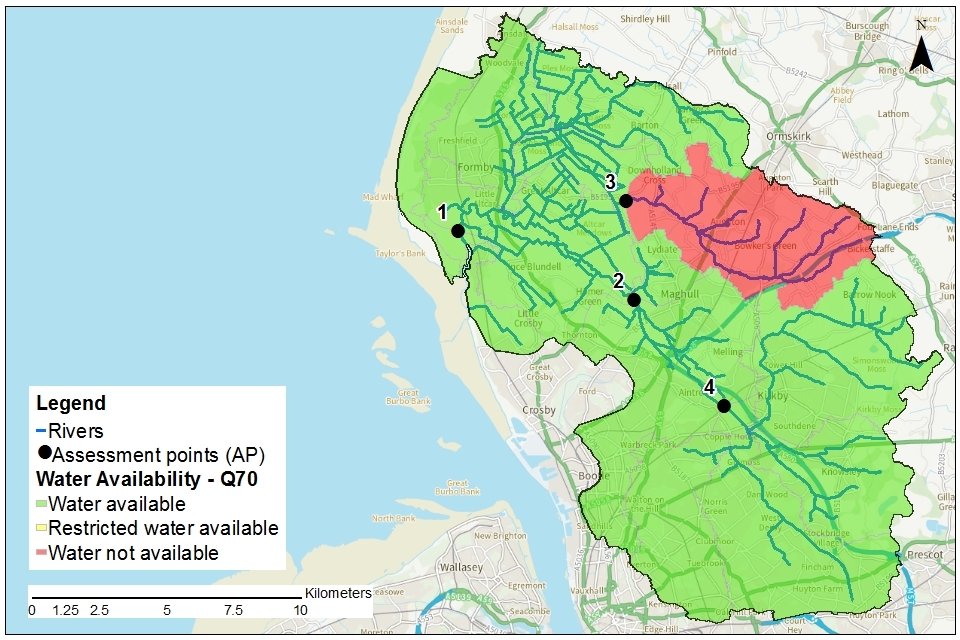
The water availability status for the Alt catchment are presented in maps 2 to 5 and the results summarised in table 1.
Table 1: summary of maps 2 to 5 - water availability at each assessment point by flow category
| Assessment point | Name | Q30 | Q50 | Q70 | Q95 |
|---|---|---|---|---|---|
| 1 | Alt at Altmouth | Available | Available | Available | Available |
| 2 | Alt at Maghull | Available | Available | Available | Available |
| 3 | Sudell Brook | Available | Available | Not available | Not available |
| 4 | Alt at Kirkby | Available | Available | Available | Restricted |
Note: water availability status given in this table is at AP level, water availability may be different at a local level.
Map 2: water resource availability colours at Q30 for the Alt catchment

© Environment Agency copyright
Map 3: water resource availability colours at Q50 for the Alt catchment
© Environment Agency copyright
Map 4: water resource availability colours at Q70 for the Alt catchment
© Environment Agency copyright
Map 5: water resource availability colours at Q95 for the Alt catchment
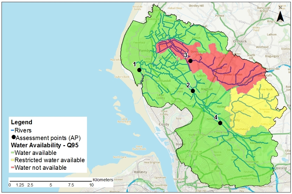
© Environment Agency copyright
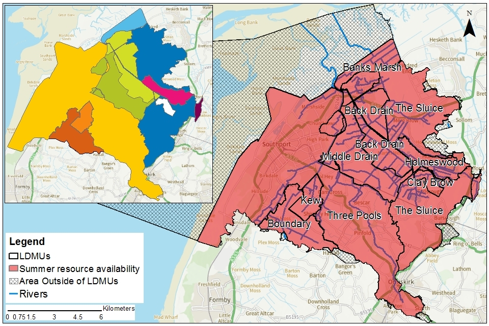
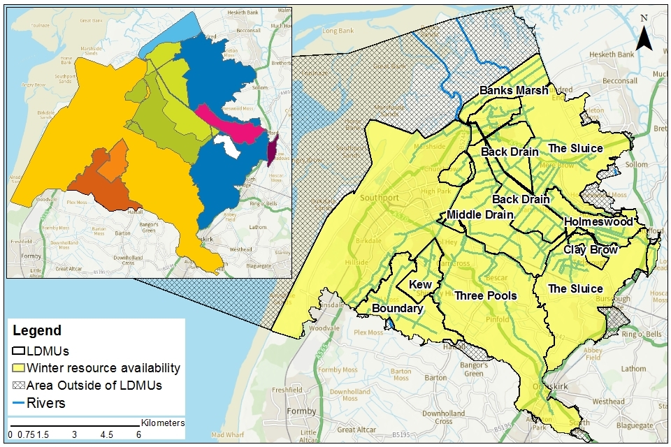
Water availability maps for the Crossens
We operate our pumping stations in the Crossens to balance water levels between the conflicting requirements of flood risk management and water resource use. We also need to protect the environment and reduce the risk of peat shrinkage. During winter months, excessive water stored in the ditches is pumped away from the lower nested catchments to the relevant main carrier. It is then pumped out to sea to mitigate flood risk. Conversely in the summer months, water levels are generally kept higher to preserve water resources for irrigation of the agricultural crops grown in the area.
We do not switch from summer levels to winter levels at any predetermined date. We change regime based on a number of factors including:
-
soil saturation
-
weather forecast
-
experience of managing the catchment
However, the switch from winter to summer has recently been between April and May. The switch from summer to winter has occurred at the earliest in the beginning of August but usually in September.
The water availability status for the Crossens catchment are presented in maps 6 and 7 and the results summarised in table 2.
Table 2: summary of Crossens maps 6 and 7 - water availability in each LDMU
| Unit | Name | Summer Water Resource Availability | Winter Water Resource Availability |
|---|---|---|---|
| LDMU 1 | Back Drain | Not available | Restricted |
| LDMU 2 | Banks Marsh | Not available | Restricted |
| LDMU 3 | Boundary | Not available | Restricted |
| LDMU 4 | Clay Brow | Not available | Restricted |
| LDMU 5 | Holmeswood | Not available | Restricted |
| LDMU 6 | Kew | Not available | Restricted |
| LDMU 7 | Middle Drain | Not available | Restricted |
| LDMU 8 | Rufford Causeway | Not available | Restricted |
| LDMU 9 | The Sluice | Not available | Restricted |
| LDMU 10 | Three Pools | Not available | Restricted |
| Crossens non LDMU | Crossens non LDMU | Not available | Restricted |
Note: water availability status given in this table is at LDMU level, water availability may be different at a local level
Map 6: summer water resource availability colours in the Crossens catchment - an inset map gives clarity to the areas covered by the different LDMUs
© Environment Agency copyright
Map 7: winter water resource availability colours in the Crossens catchment - an inset map gives clarity to the areas covered by the different LDMUs
© Environment Agency copyright
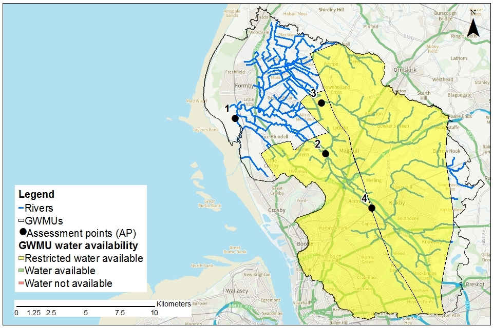
3.2 Groundwater resource availability
Groundwater availability is a measure of how much groundwater is available for abstraction, after the river flow requirements for ecology have been met.
The principal Permo-Triassic Sandstones aquifer has been divided into groundwater management units (GWMUs). The groundwater availability is assessed for these units. The units in the catchments are the:
-
Kirkby Ormskirk GWMU
-
Liverpool Speke GWMU
-
Rufford GWMUs
Water availability has been assessed using a number of tests including using monitoring data and numerical modelling. Liverpool Speke and Rufford GWMUs extend into other ALS catchments.
In certain areas, resource concerns over groundwater mean that the standard water resource availability colours have been overridden.
Outside of the GWMUs, and for overlying superficial deposits, groundwater availability is assessed using the surface water availability at the most appropriate AP, or LDMU. In these places, we take into account the local hydrogeological setting.
Groundwater availability is an important consideration in any possible future peatland restoration, carbon farming or paludiculture projects.
Groundwater resource availability colours and implications for licensing
We use colours to represent different groundwater availability:
Restricted water available for licensing
Yellow
Groundwater unit balance shows more water is licensed than the amount available or there are local impacts such as saline intrusion. But the actual situation is sustainable because either:
-
recent actual abstractions are lower than the amount available
-
management options are in place to deal with the known impacts
In restricted groundwater units no new consumptive licences will be granted if more water is licensed than the amount available. We may also investigate the possibilities for reducing fully licensed risks. Water may be available if you can ‘buy’ (known as licence trading) the entitlement to abstract water from an existing licence holder.
Groundwater availability maps
The groundwater availability maps show there is restricted water available for new consumptive abstraction across all GWMUs. For the Liverpool Speke unit the restrictions are related to saline intrusion along the coast and estuary, with water available away from the coast.
Map 8: groundwater availability in the Alt area
© Environment Agency copyright
Map 9: groundwater availability in the Crossens area
© Environment Agency copyright
3.3 Resource reliability
If you want to apply for a licence, it’s worth considering the reliability of your surface water abstraction.
By assessing the quantity of water available at different flows it’s possible to see:
-
when there is a surplus or deficit of water
-
the associated reliability of an abstraction
This is an indication only. Actual reliability of a licence will be discussed when you apply.
Alt
Map 10 gives an indication of the resource availability for consumptive abstraction in Alt catchment expressed as a percentage of time. In this catchment:
-
AP1: Consumptive abstraction is available at least 70% of the time
-
AP2: Consumptive abstraction is available at least 95% of the time
-
AP3: Consumptive abstraction is available at least 50% of the time
-
AP4: Consumptive abstraction is available at least 70% of the time
Map 10: water resource reliability of the Alt ALS expressed as percentage of time available
© Environment Agency copyright
Crossens
We are currently unable to provide an indication of the resource availability for consumptive abstraction expressed as a percentage of time. However, we will treat each application on its own merit to assess potential resource reliability.
3.4 Other considerations for resource availability and reliability
We will add constraints to licences such as hands off flow (HoF) and hands off level (HoL) conditions to protect:
-
the environment
-
the rights of other abstractors
As a result, when we grant a licence, it does not mean that we guarantee a supply of water. These conditions specify that if the flow in the river drops below what’s needed to protect the environment, abstraction must reduce or stop. In dry years, restrictions are likely to apply more often. This will affect the reliability of supply.
There is no guarantee that we will grant licences even where water is available for abstraction. This is because we have to determine each application on its own merits. Local factors may mean we’re either unable to grant a licence as applied for, or even at all.
New licences within a catchment are usually given a common end date (CED), which allows them to be reviewed at the same time. The next CED for this ALS, covering the Alt Crossens, is 2028 and the subsequent one is 2040.
3.5 Impoundments
Applications for impoundments will be dealt with on a case-by-case basis. More information may be found on our water management web pages.
4. How we manage water availability in the Alt Crossens
4.1 Surface water
Alt
We assess surface water flows at assessment points (APs), which are significant points on a river, often where 2 major rivers join or at a gauging station. APs cover multiple surface water bodies.
Where groundwater abstractions directly impact on surface water flows, the impact is measured at the surface water AP. This is because the flow in a river can be made up from groundwater as well as rainfall runoff from the land. In the Alt catchment groundwater in the sandstone aquifer feeds both the River Alt and Sudell Brook. This impact is seen at all APs in the Alt. Groundwater abstractions can lower the water table here and reduce groundwater inputs and affect surface water flows and the ecology.
Table 3 gives an indication of:
-
how much water is available for further abstraction
-
the associated restrictions we may have to apply to new and varied abstraction licences from the main river
Depending on the nature of the catchment, tributaries to the main river may be subject to different restrictions and quantities. This may be assessed locally on a case-by-case basis.
Each HoF is linked to an AP and is dependent on the resource availability at that AP. In some cases additional restrictions may apply to licences where there is a more critical AP resource availability downstream. This protects the ecological requirements of the river and other water users.
All abstraction licence applications are subject to an assessment. This takes account of any local and downstream issues. It may be subject to further restrictions.
Reading from top to bottom in table 3 are the APs in the Alt ALS area. Reading across the columns you can see:
-
the potential HoF that may be applied to a licence
-
the number of days water may be available under this restriction
-
the approximate volume of water in Ml/d that may be available.
In cases where there is water available at all flows we may apply a minimum residual flow (MRF) to protect very low flows. We’ll decide this on a case-by-case basis.
Table 3: summary of licensing approach for the assessment points of the Alt
| AP | Name | AP National Grid Reference (NGR) | Water Resource Availability | HOF Restriction (Ml/d) | Number of days per annum abstraction may be available | Approximate volume available at restriction (Ml/d) | Is there a gauging station at this AP? |
|---|---|---|---|---|---|---|---|
| 1 | Alt at Altmouth | SD 29195 04905 | Available | 62 | 365 | 38.4 | No |
| 2 | Alt at Maghull | SD 35742 02322 | Available | 30 | 365 | 26.5 | No |
| 3 | Sudell Brook | SD 35429 06009 | Available | 1 | 340 | 0.2 | No |
| 4 | Alt at Kirkby | SJ 39098 98378 | Available | 25.6 | 365 | 31.8 | Yes |
Crossens
As mentioned in section 3, how we assess water availability in the Crossens catchment is currently being reviewed. This will then feed into how we manage water availability.
Water availability will be influenced by many factors including:
-
ditch properties such as length, width and depth
-
target water levels to protect the peat and environment
-
inflows such as discharges and rainfall
-
pumping
-
protection of water assigned to existing abstractors
A key part of our investigation is how water in the catchment has been assigned to existing abstractors. Once we understand what water is available and what has already been licenced away then we will know how much is available for future use.
Licences have historically been mainly linked to hands off flows or hands off levels. Some do not have any restriction.
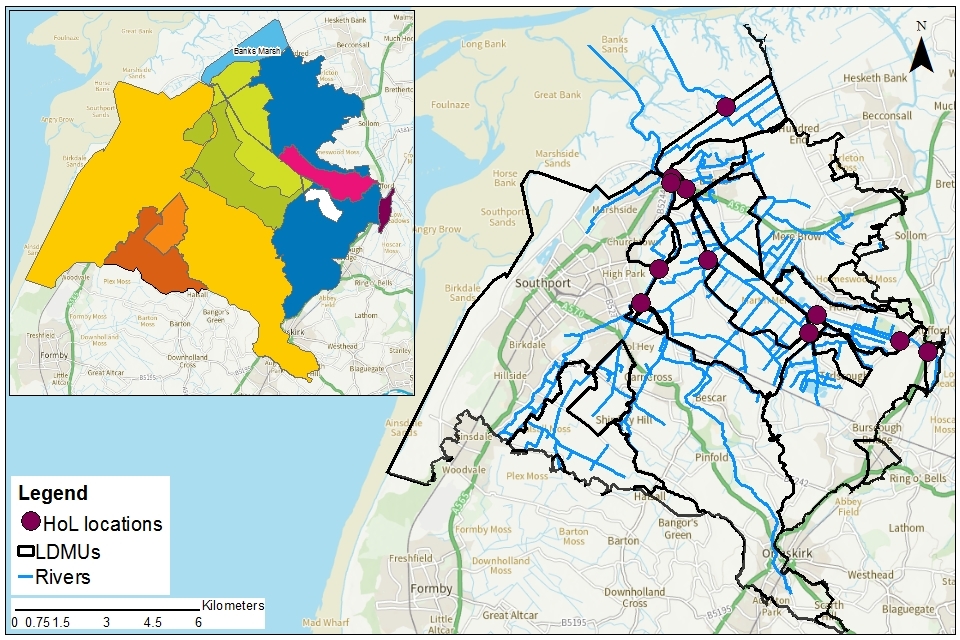
Hands off flows were set locally and immediately downstream of the point of abstraction. Hands off levels were set either at a pumping station so as to relate directly to the pumping regime or at one of 5 gauges across the catchment. These gauges are at
-
Brook Farm Bridge at NGR SD 367 166
-
Ford Bridge at NGR SD 422 156
-
Moss lane Bridge at NGR SD 373 177
-
Winacre Brow Farm Bridge at NGR SD 389 180
-
Water Lane Bridge at NGR SD 382 203
We are aware of some issues with regard to these restrictions and that will be part of our review.
Map11: location of gauges and pumping stations linked to hands off level licence conditions
© Environment Agency copyright
4.2 Groundwater
As mentioned in section 3.2, there are 3 groundwater management units (GWMU), in the Alt Crossens catchment. The water availability status for these GWMUs is shown below.
Where groundwater abstractions directly impact on surface water flows the impact is measured at the surface water AP. This includes where the impact reduces baseflow. In these cases, restrictions may be applied to licences, such as hands off level (HoL) conditions. The HoL is a groundwater level below which an abstractor is required to reduce or stop taking water.
Other restrictions may apply where availability is limited or to protect the environment, for example to prevent saline intrusion.
Table 4: licence restrictions on groundwater abstractions in the Alt Crossens ALS area
| Groundwater body | Groundwater management unit | Water resource availability | Reason for restriction | Volume available (Ml/d) |
|---|---|---|---|---|
| Lower Mersey Basin and North Merseyside Permo-Triassic Sandstone aquifers (principal aquifer) | Kirkby / Ormskirk | Restricted | Over licensed on water balance | -43.4 |
| Lower Mersey Basin and North Merseyside Permo-Triassic Sandstone aquifers (principal aquifer) | Liverpool Speke | Restricted | Potential for saline intrusion along the coast, water available inland | 12.8 |
| Rufford Permo-Triassic Sandstone aquifers (principal aquifer) | Rufford | Restricted | Aquifer fully committed due to local conditions and very limited recharge | 0 |
| West Lancashire Quaternary Sand and Gravel aquifers | N/A | Restricted | Availability will depend on surface water availability | NA |
4.3 Level dependent environments
The Alt Crossens area contains 2 level dependent environments (LDE). One is within the Alt catchment and the other covers nearly the whole of the Crossens catchment. Each LDE is divided into smaller units, known as level dependent management units (LDMU).
In the Alt there are 2 LDMU. We don’t set a different licensing approach within the LDMU. Water availability is still set at the APs. In the Alt catchment we have a one-way pumping regime with water being moved from the ditches up to the River Alt.
In Crossens there are 10 LDMU. For further detail see section 3.1. We are reviewing our historic licensing approach in Crossens and will consider this along with water availability to find a way forward.
4.4 Coasts and estuaries
All of the coast within the Alt Crossens catchment is designated for its environmental features. The most important in terms of freshwater is Sefton Coast as it has notable semi aquatic species. They include:
-
natterjack toad
-
great crested newt
-
notable flora supported by the presence of humid dune slack habitats
The Ribble and Alt Estuaries SPA overlaps the Ribble Estuary SSSI and Sefton Coast SSSI. The site consists of extensive areas of sandflats and mudflats, as well as large areas of saltmarsh and areas of coastal grazing marsh. The site supports significant numbers of breeding, over-wintering and passage seabird assemblages.
4.5 Protected areas
The Conservation of Habitats and Species Regulations 2017 (Habitats Regulations) provides a very high level of protection to 2 types of designated sites due to their special environment. These are:
*Special Areas of Conservation (SAC), which contribute to biodiversity by maintaining and restoring habitats and species
*Special Protection Area (SPA), which provides protection to birds and their nests, eggs and habitats
Government policy treats Ramsar sites (internationally important wetland sites) in the same way as SACs and SPAs. Ramsars, SACs and SPAs are referred to collectively as European sites. Sites of Special Scientific Interest (SSSI) also carry a high level of environmental importance.
Conservation objectives are the main objectives for European and SSSI protected sites to maintain at, or to reach, favourable condition. These are set by Natural England. The process for setting targets is described through the Joint nature conservation committee approved ‘Common Standards Monitoring Guidance’ (CSM). Natural England use these targets to assess the condition of European and SSSI protected sites. These quantitative targets are considered by Natural England as a pre-requisite for achieving the conservation objectives for European or SSSI designated sites. We have a duty to have regard to Natural England’s advice when determining licence applications that may impact on a designated site.
We may need more detailed supporting information when a licence application could impact on a designated conservation site. This will allow us to complete the required statutory assessment.
As mentioned in section 4.4, the whole of the Alt Crossens coast is designated for its environmental features.
In the Alt catchment, there is Downholland Moss SSSI which lies in the level dependent unit. Part of the Sefton Coast SSSI, Ramsar and SPA lies in the tidally influenced zone outside the CAMS area.
The Alt catchment also supports a dense population of water voles and is one of the best catchments for them in the Northwest Region. From an abstraction perspective, it is important that the drainage ditches within the Alt are not over-abstracted in the summer months. Water voles need to have flowing water, even if only low flows.
Water voles are a priority UK Biodiversity Action Plan (BAP) species. The Environment Agency is a lead partner for the water voles species action plan. Actions include:
-
incorporating water vole conservation into integrated area management plans
-
ensuring that development schemes do not affect the integrity of water vole population
In Crossens, inland there are water dependent SSSIs at:
-
Martin Mere (SPA, RAMSAR, SSSI)
-
Mere Sands Wood SSSI
Martin Mere is a low-lying wetland complex of open-water, marsh and grassland habitats overlying deep peat. It occupies part of the site of the old Martin Mere which, prior to drainage, was probably the largest lake in Lancashire. The site has a fragile hydrological buffer between the (higher) Sluice and low level Back and Middle drain pumped drainage systems.
On the River Alt, Downholland Moss SSSI is required to be managed in a way that preserves its geological interest features which are below the peat surface. Water levels and vegetation management are important for this site. Accelerated pump drainage has however resulted in peat shrinkage and lowered land levels. This has led to the vegetation in the surrounding drainage ditches scrubbing up.
5. Managing the catchment together
5.1 Action on unsustainable abstraction
Managing water abstraction gives details on:
-
what an unsustainable abstraction is
-
the measures available to resolve environmental issues caused by abstraction
Crossens in particular has a large concentration of abstraction licences. These licences are predominantly for spray irrigation of arable crops, which is of economic and national importance. However, we are aware that there are some issues with the licences. An example of this is where ditch levels have changed and water is no longer available due to the hands off level restriction. This is why we have started a review of both the water availability for future use and the existing licences.
Our aim is to continue to engage with abstractors and to find a way forward that will:
-
protect the unique environment of Alt Crossens
-
deliver sustainable abstraction
-
support economic growth
-
enhance a water environment that will support health and wellbeing
Our first step is to better understand what water is available in the catchments and to review the existing licences. We want to work with abstractors to better understand:
- the complexities of this area
- how the current licences deliver on the needs of abstractors and the environment
Whilst this is underway, we will:
-
constrain new licences and upward variations
-
limit the volumes of water that can be traded
-
allow winter storage licences when our pumps are in operation
-
consider sustainable abstraction and need on time limited licences
-
continue to control the area of land on which each licence can be used
-
bring abstractions affected by the New Authorisations programme into the abstraction licencing regime
We will review the licences in existence by:
-
checking the licences are held by the right person or company
-
follow up when there are incorrect or missing records
-
continue our programme of pursuing revocation of unused licences and reduction of underused licences
During drought periods we will consider use of s57 Water Resources Act 1991 spray irrigation restrictions. These will impact on any licences that do not have hands off flow conditions to protect the environment.
We will pursue opportunities to listen to and engage with local communities. We will work to see an improved water environment that serves the needs of water users, the environment and the people of this unique area.
5.2 Approaches to sustainable water management
This section outlines options initiated in this catchment for future approaches to water management. This includes collaboration and sharing which may be of interest to both new and existing abstractors.
Through catchment based working in the Alt Crossens priority catchment we have undertaken a range of initiatives.
Water Friendly Farming Group
The Alt Crossens has benefited from the creation of a Water Friendly Farming group. This is a sub-group of the successful Alt Crossens Catchment Partnership, led by Mersey Rivers Trust.
The Water Friendly Farming Group includes representatives from:
-
Environment Agency
-
National Farmers Union
-
Catchment Sensitive Farming
-
Mersey Rivers Trust
-
United Utilities
It provides an opportunity for farmers, growers and landowners to share best practice to improve sustainability. The group also provides the opportunity to obtain assistance and guidance from key partners.
A number of advisory workshops have been run by the Water Friendly Farming Group. Further details are available via the Water Friendly Farming Hub on the Mersey Rivers Trust website.
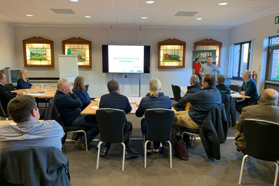
The photograph shows people at a Water Friendly Farming workshop.
Case study: irrigation demonstration farm
Through collaboration within the Water Friendly Farming group, funding was successfully obtained to construct an Irrigation Demonstration Farm, within the Crossens catchment. This will enable visitors to observe the benefits of using industry best practice for crop irrigation. It will also include demonstration of drip feed/trickle irrigation systems and rainwater storage lagoons.
The Irrigation Demonstration Farm will be in place from late Spring 2022. Engagement events will be organised to allow visitors the opportunity to view the installation and ask any questions. We welcome enquiries from growers keen to improve the resilience on their farm through alternative irrigation techniques or installation of rainwater storage lagoons.
In attendance at the Irrigation Demonstration Farm events will be representatives from:
-
local authorities
-
Environment Agency
-
NFU
-
Catchment Sensitive Farming
-
irrigation suppliers
-
storage lagoon engineers
Details of these events will be shared via the Water Friendly Farming Hub.
The demonstration farm will cover an area of 17 acres. One half will be irrigated with drip feed/trickle irrigation and the other half irrigated with spray irrigators. Measurement devices will be included, which will enable detailed analysis of:
-
water usage
-
fuel usage
-
crop benefit
-
yield
Working with natural processes in the catchment
Natural processes help to store water in the ground and slow down the rate at which it enters river systems. Evidence shows that taking action to restore natural processes can help make some catchments more resilient to flood events. We have completed a new study to provide evidence for the benefits of working with natural processes. This will improve resilience to drought.
In the Alt Crossens catchment, the study indicated that the following could help, if done in the right places:
-
runoff attenuation features
-
modification of the lowland drainage system (including peat restoration)
Outputs from the project include maps showing where these actions are most likely to be effective. More details are available on the Environment Agency’s priority catchments website.
Future water resources management
Water scarcity on the Alt Crossens is generally limited to the summer months. Very few growers benefit from water storage during this period. This combined with inefficient irrigation practices puts further pressure on water availability.
As a result of this, future management of water resources within the Alt Crossens catchment will focus on:
-
best practice irrigation
-
storage of irrigation water
We will work with partners such as Catchment Sensitive Farming and Local Authorities to assist growers who wish to improve their resilience.
Work is ongoing, which will improve understanding of the water availability within the catchment through modelling.
We will encourage more sustainable irrigation practices within the catchment. We will assist those who wish to improve water usage and efficiency by:
-
supporting winter storage options
-
starting summer irrigation patrols
-
tackling non-compliant or illegal abstractors
-
taking action on non-compliant or illegal impoundments
Protecting the peat and paludiculture trials
Lowland peatlands provide some of the country’s most fertile soils and play a vital role in food production. Centuries of draining these areas to support intensive agriculture have led to degraded peat soils. These soils emit more than 9 million tonnes of greenhouse gas emissions per year.
We have been working on land levels and peat to understand where the peat is and to get a better understanding of changes in levels. With others, we are investigating alternative land and water management to help slow, stop or repair soil loss and shrinkage.
The Lowland Agricultural Peat Task Force (LAPTF) s exploring ways for our peatlands to:
-
improve resilient to flooding
-
improve resilience to drought
-
mitigate climate change by protecting the carbon stored in soil.
A subgroup of LAPTF for paludiculture are developing a road map. This sets out a series of actions to be undertaken over the next 10 years to enable paludiculture to become a viable way of conserving carbon. This can be achieved by raising the water table in peat soils, whilst maintaining a (different) peatland agricultural land use. This will be published as part of the task force’s final report.
In early 2022 representatives took part in paludiculture (wet agriculture) workshops in Crossens. These included:
-
Environment Agency
-
Natural England
-
DEFRA
-
Lancashire Wildlife Trust
-
academic institutions
-
National Farmers Union
-
Alt Crossens farmers
This subgroup of the LAPTF discussed the key barriers to transition to paludiculture and how they may be overcome. This was one of 4 face to face regional workshops - the outputs of which will be available in the summer of 2022, and will help the LAPTF in making future agricultural policy recommendations.
Further details can be found in the New chair to lead task force on sustainable farming of peatlands article on GOV.UK. Measures in the England Peat Action Plan will increase drought resilience and the sustainability of our freshwater supplies.
5.3 Water rights trading
A water rights trade is where a person sells all or part of their water right, as defined by their abstraction licence(s), to another person on a permanent or temporary basis. In the majority of cases a trade will involve a change in abstraction location and/or use. We will need to approve through the issue or variation of abstraction licences.
In licensing trades, as with new abstraction licences, we need to make sure that we do not cause any deterioration in water body status. This is both:
-
within the water body / bodies where the trade will take place
-
to downstream water bodies
We will consider water rights trading on a case-by-case basis but limit the volumes to protect the environment and other water users.
To find out more about licence trading please go to our water management web pages.
We are aware of informal water trading occurring within the catchment. This is where someone uses the licence of another without a licence trade. This has risks for both the licence holder and the person using the water should something go wrong. We encourage all licence holders taking part in water trading to contact the Environment Agency first and where appropriate to formalise the agreements that have been made.
5.4 Case studies in other catchments
More information on work in other catchments can be found in the updated ALS for:
6. Related links
-
Agriculture and Horticulture Development Board (AHDB) website - provides information on effective use of water on livestock farms
-
Catchment Based Approach community website - provides further information on the catchment based approach
-
UK Centre for Ecology and Hydrology Drought Portal - is an interactive portal presenting information on the latest hydrological situation across the UK
-
Environment Agency, how to apply for a water abstraction or impoundment licence web pages - provide all the information needed to go through the application process to get a licence
-
Environment Agency manage your water abstraction or impoundment licence online web service - allows abstractors to view and share licence information and submit abstraction returns
-
Environment Agency priority catchments website - provides further information about the priority catchment work
-
The Environment Agency National Framework for Water Resources -explores England’s long-term water needs and the importance of planning at the regional scale and link to the catchment scale
-
Linking Environment and Farming (LEAF) Simply Sustainable Water guide - explains 6 simple steps for managing water quality and use on your land
-
National Farmer’s Union web pages on Irrigation and water resources - provide useful information
-
Natural England’s website - provides further information on protected sites and species
-
Environment Agency and Cranfield University’s guide to planning, designing, constructing and commissioning a water storage reservoir – if you are considering an irrigation reservoir
-
The UK Irrigation Association and Cranfield University - provide a range of irrigation booklets that tackle key issues
-
Waste and Resources Action Programme website has guidance on water efficiency in the food and drink industry
-
Waste and Resources Action Programme website has a guide to water saving devices and practices
7. Glossary
Abstraction - removal of water from a source of supply (surface or groundwater).
Abstraction licence - the authorisation granted by the Environment Agency to allow the removal of water.
Assessment point - a significant point on a river, often where two major rivers join or at a gauging station.
Catchment - the area from which precipitation and groundwater will collect and contribute to the flow of a specific river.
Catchment based approach - partnership working at the river catchment scale to deliver a range of environmental, social and economic benefits while protecting our precious water environments for the benefit of all.
Consumptive abstraction - abstraction where a significant proportion of the water is not returned either directly or indirectly to the source of supply after use. For example for the use of spray irrigation.
Discharge - the release of substances (for example, water, treated sewage effluent) into surface waters.
Environmental flow indicator - flow indicator to prevent environmental deterioration of rivers, set in line with new UK standards set by UKTAG.
Groundwater - water that is contained in underground rocks.
Hands off flow - a condition attached to an abstraction licence which states that if flow (in the river) falls below the level specified on the licence, the abstractor will be required to reduce or stop the abstraction.
Impoundment - a structure that obstructs or impedes the flow of inland water, such as a dam, weir or other constructed works.
Paludiculture - a sustainable land use alternative on peatlands which is carbon neutral or negative in the long term.
Surface water - this is a general term used to describe all water features such as rivers, streams, springs, ponds and lakes.
Water body - units of either surface water or groundwater which we use to assess water availability.
8. Copyright - maps
© Environment Agency copyright and/or database right 2020. All rights reserved. This map includes data supplied under licence from: © Crown Copyright and database right 2020. All rights reserved. Ordnance Survey licence number 100024198.
9. Contact details for further information
For local water resources advice contact the Cumbria and Lancashire Integrated Environment Planning Team. You can either call or email the team:
-
call 03708 506 506 (calls cost no more than a national rate call to an 01 or 02 number)