Work on Lower Otter's new embankment and bridge starts next week
Work to start to build bridge supports, piers and earth road embankment.
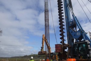
A tall crane with a tall screw like pile and thin metal cage next to it
- The bridge and embankment will be constructed above the height of the existing floodplain
- It will provide access to a more resilient road in times of flooding
Building of the new road embankment and a 30 metre-span bridge, to carry vehicles over the new creek network on the west of the Lower Otter valley in Budleigh Salterton, enters a new phase next week.
The concrete foundation piles for the bridge are now complete and building upwards will begin. This includes the construction of the piers and supports of the bridge (abutments) and the earth embankment for the road itself which will go across the valley parallel to the existing road.
The embankment will eventually be 2.5 metres higher than the current South Farm Road – the same level as the nearby White Bridge – lifting it above the level of the floodplain.
Dan Boswell, Lower Otter Restoration Project manager for the Environment Agency, said:
This is a fascinating opportunity to see civil engineering in action. Although it will look very big initially, after about 4 months the surcharged embankment will be re-shaped and reduced in height before the final road surfacing is constructed.
Towards the end of the year, the new embankment will be connected to White Bridge before it crosses the River Otter – White Bridge will remain unchanged. To minimise disruption while the new road is being built and connected, later this year a short section of temporary private road providing access to the east of the river will be built. The new bridge is expected to be complete during the autumn.
The project is part of the €26 million Promoting Adaptation to Changing Coasts project, which also has a similar scheme underway in the Saâne Valley in Normandy, France. In Devon it will see current grassland, created during historic reclamation work, replaced with 55 hectares of intertidal mudflat and saltmarsh, plus a net gain of more than 2 hectares of broadleaved woodland and 1.5 kilometres of hedgerow.
Notes to editor
Building the embankment involves temporarily ‘over-building’ or ‘surcharging’ the structure to around 4.5 metres (an extra 2 metres) in order to compress the underlying ground to ensure that the material under the new road is sufficiently strong to carry it.
The French arm of the project is in the Saâne Valley in Normandy and includes building a new water treatment works and moving a campsite at Quiberville.
It is thought that up to 70 estuarine sites in northern France and southern England may benefit from the PACCo project, by following the model being used on the Lower Otter and Saâne Valley. A “how to” guide is being developed as part of the project to help organisations decide if a similar scheme would benefit their areas.
The European Regional Development Fund is providing funding via the Interreg VA France (Channel) England programme.