RAF deploys surveillance aircraft to flood-hit areas
The RAF has provided high-tech surveillance equipment to capture detailed aerial pictures of the flood-hit areas of the UK.
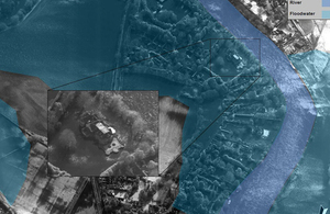
An electro-optical image of the extensive flooding in Bourne End, Buckinghamshire [Picture: Crown copyright]
The service deployed a Tornado GR4 fast jet and a Sentinel R1 aircraft to produce images that will aid the planning and co-ordination of multi-agency efforts to provide relief to local residents and communities.
The Sentinel mission followed the Tornado sortie that took place on Thursday which saw the Tornado’s reconnaissance pod produce optical imagery that will complement the Sentinel’s radar pictures.
Defence Secretary Philip Hammond said:
With thousands of military personnel already playing their part in efforts to help flood-affected communities, the RAF is now delivering this additional and highly specialist support.
This Tornado-borne surveillance capability is very much proven in a combat role in Afghanistan but its versatility is underlined by its use here at home to support ongoing flood relief efforts.
As the Prime Minister has made clear, whatever assets we have at our disposal that can make a difference, we will use them.
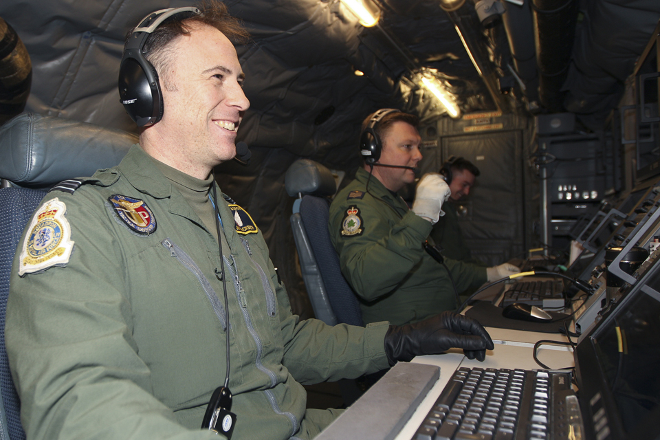
Inside an RAF Sentinel R1 aircraft operated by personnel from No 5 (Army Co-operation) Squadron [Picture: Senior Aircraftman Clarke, Crown copyright]
Reconnaissance pods fitted to Tornado aircraft have been used in many military operations and are currently in use over Afghanistan. They can rapidly scan and capture a huge area of interest in just one sortie – in this case areas in need of flood relief work.
The Sentinel system delivers all-weather tactical surveillance information using powerful processing techniques to produce photo-like imagery of the ground from radar returns.
These images will be converted into large-scale mapping to assist with strategic planning and early identification of those areas at the highest risk of further flooding.
In particular, by using the imagery gathered by the Sentinel, civilian authorities will be able to compare the current flooding in the Thames Valley to how the same area was affected during a similar devastating period of flooding in 1947 which was caused by melting snow and extended periods of heavy rain.
Being able to draw comparisons may help to identify which areas are most likely to be affected next and help the civilian authorities to make informed decisions about where best to target their efforts.
No 5 (Army Co-operation) Squadron operates the Sentinel. Squadron Leader Victoria Fulton said:
We are working closely with the relevant civilian authorities to provide whatever assistance we can. The Sentinel has long-range capabilities which enable highly-trained airborne image analysts onboard to capture imagery of large parts of the flooded areas.
It is hoped that this key information will greatly assist the civilian authorities when determining where best to focus their efforts.
Sergeant Kevin Crowhurst, an airborne image analyst with No 5 (Army Co-operation) Squadron, said:
The flooding has had a devastating effect on large parts of the country, so the squadron was delighted when asked to assist, and we have looked to provide as much information as possible to help bring some respite to the affected communities.
Updates to this page
-
Updated imagery
-
First published.