Exploring Anguilla’s marine environment through geospatial data
The UK Hydrographic Office (UKHO) is working with the Government of Anguilla (GoA) to provide geospatial data to support safe navigation
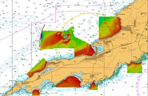
Figure 2: Data collected during the 2018 vessel- based survey
In 2016, the UKHOi was enlisted to help improve Anguilla’s compliance with the International Maritime Organization’s (IMO) Safety of Life at Sea (SOLAS) Convention. The project was funded by the Foreign Commonwealth and Development Office (FCDO) under the UK Government’s Conflict Security and Stability Fundii (CSSF). At the time, the UKHO and the GoA recognised the need to form a strong collaborative relationship to further progress maritime compliance obligations.
Over the past seven years the UKHO has worked with the Anguilla Maritime Administration and Shipping Registry (AMASR), through the Overseas Territories Seabed Mapping Programme (OTSMP), on activities related to SOLAS Chapter V Regulation 9 – Hydrographic Services. The UKHO undertook an initial technical assessment to establish the baseline for the island’s existing hydrographic information, before developing a report on how to support the planning of future programme activity.
Using a risk-based model incorporating shipping movement data, quality of existing seabed mapping surveys and water depth within Anguilla’s waters, a survey plan was identified to reduce the risk of maritime incidents. Two seabed mapping surveys were conducted in 2016 and 2018 respectively to improve the quality and accuracy of marine data, to support SOLAS and to update the compliant marine navigational products and services available via the UKHO to mariners through ADMIRALTY Maritime Data Solutions.
In 2016, an airborne survey captured data from both the terrestrial and marine environments to around 40m deep. The collection of aerial imagery supplemented the data.
Figure 1: Location map of Anguilla and coverage of the airborne seabed mapping survey
In 2018, a further survey was conducted using a ship to collect data in areas of important vessel movement. This exercise involved collecting information in seven primary areas as illustrated in Figure 1, which shows additional exploration of wrecks identified in the 2016 survey.
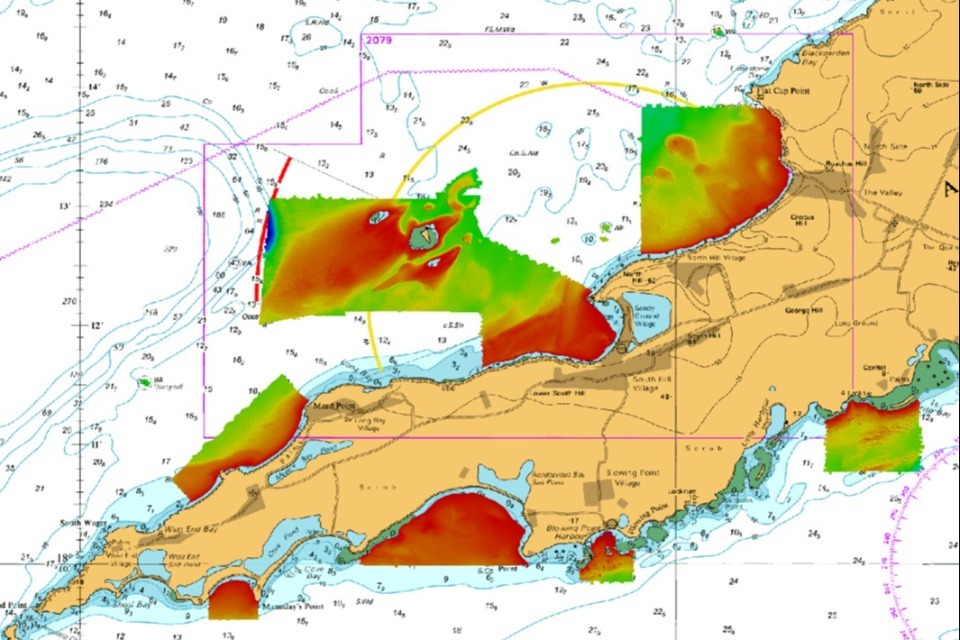
Figure 2: Data collected during the 2018 vessel-based survey
Following the technical assessment, the UKHO worked with AMASR on improving hydrographic governance. A workshop was held at the UKHO with other Overseas Territories to build understanding and to share best practice, recently culminating in the production of a Hydrographic Action Plan (HAP). The HAP provides a roadmap for AMASR to work with other Anguilla stakeholders, and for the UKHO to help them improve compliance with SOLAS. This compliance is particularly important as the IMO regularly audits Member States.
AMASR informed the UKHO about the development of a new jetty and requested an effective approach for gathering accurate data on the tide movements in Road Bay. The UKHO has since facilitated the procurement and installation of a Marine Environmental Monitoring Station (MEMS) on the jetty. The MEMS will provide real-time vertical movement of the sea level and meteorological data to support marine operations.
The MEMS data is linked to the UNESCO sea level station monitoring network, which provides real-time information on the operational status of global and regional networks of sea level stations. This gives the scientific community access to the Intergovernmental Coordination Group for the Tsunami and Other Coastal Hazards Warning System for the Caribbean and Adjacent Regions, which supports transnational challenges such as climate change and extreme weather events.
All information collected via the OTSMP is accessible to the GoA through an online data portal, where insights can easily be stored or shared. Seabed mapping data gathered through the portal has been used by UK agencies to support further UK Government-funded initiatives, such as inundation mapping and reconstruction projects following Hurricane Irma.
Sharmer Fleming, Director of Maritime Affairs, Anguilla Maritime Administration and Shipping Registry, said:
The working relationship established between the Government of Anguilla and the UKHO has been quite effective. The outputs achieved have advanced the GoA’s progress with meeting its maritime obligations, which are pertinent to safe navigation. Furthermore, there is an appreciated higher level of understanding of Anguilla’s marine environment, which has enabled the adoption of a strategic approach towards developing the marine space in a sustainable manner.
Through the OTSMP, the GoA has received data that gives ministers a greater understanding of the marine environment – enabling them to manage, protect and develop the island’s blue economy, enhance international trade, and respond to the effects of climate change.
Footnotes
i The UKHO is a world-leading centre for hydrography, working across government as the UK’s advisor on seabed mapping, specialising in marine geospatial data.
ii The UK Conflict Security and Stability Fund (CSSF) is a unique cross-government fund that supports creative solutions to meet the most complex national security challenges and promote international peace and stability. Operating in 85+ countries and territories, the CSSF enables 17 government departments and agencies to address security priorities collaboratively.
Images from the surveys
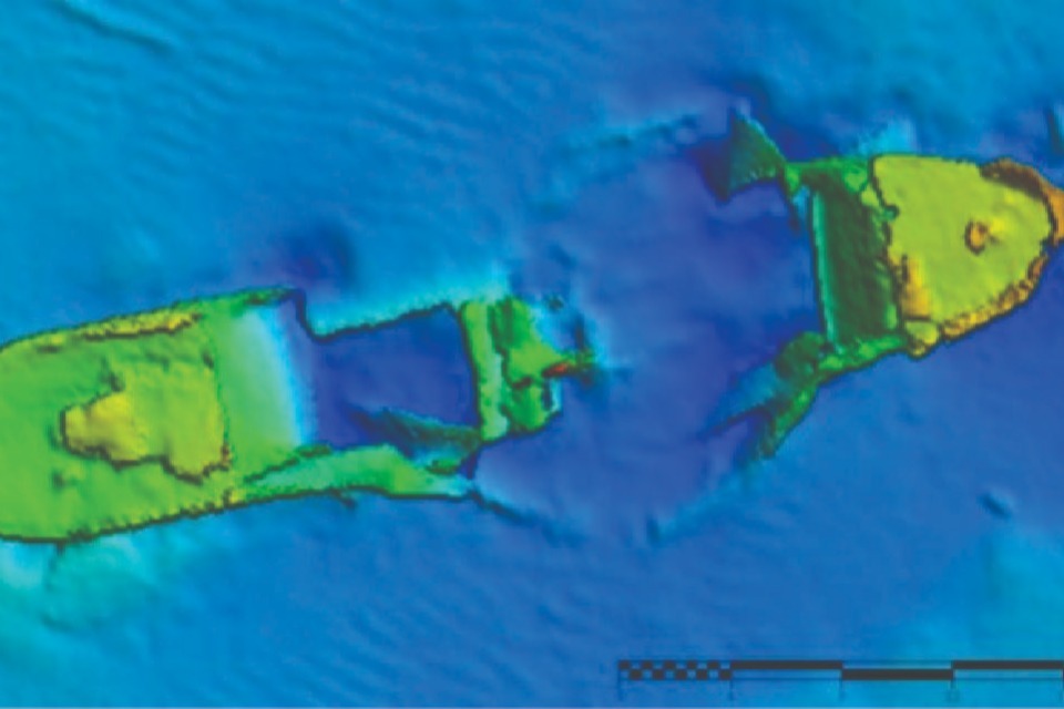
Wreck in plan view.
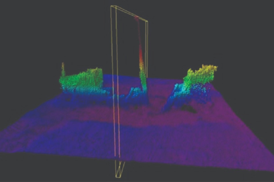
The same wreck as above in side view showing the shallowest point of 6.6m beneath the surface, which is considered a danger to navigation.
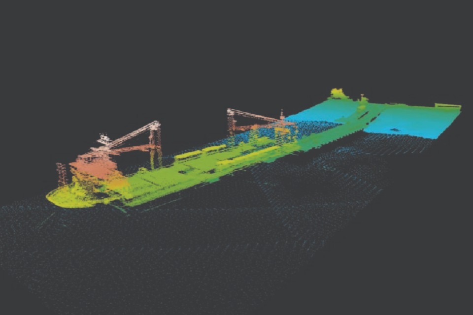
Data from the aerial (Lidar) survey showing a vessel docked at the Road Bay jetty for cargo unloading.
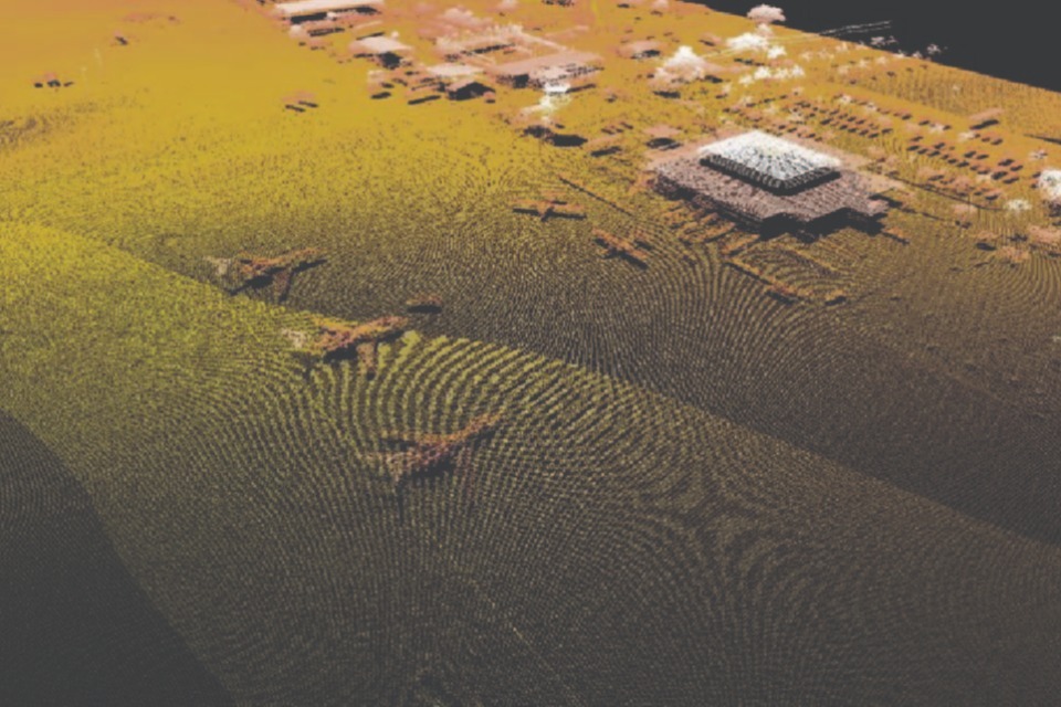
Data from the aerial (Lidar) survey showing the Clayton J. Lloyd International Airport.