Hounslow makes design codes clearer using interactive mapping
Hounslow tested an interactive map-based tool to help residents explore its 700-page design code more easily.
Estimated reading time: 6 minutes
London Borough of Hounslow carried out a pilot to test an interactive map-based tool for presenting its character and design code.
- Outcome: The council made the design code easier to explore by breaking it into themed journeys and interactive maps.
- Technology used: Local Plan Maker, a platform developed by Urban Intelligence that combined maps, images, story-based journeys and embedded consultation features.
This was a PropTech Innovation Fund round 1 pilot (2021 to 2022) and describes what was tested at the time.
The planning challenge
Hounslow’s draft character and design code was more than 700 pages long. Officers recognised that most residents would find the document difficult to navigate. They wanted a clearer and more visual way for people to explore:
- place-based visions and neighbourhood character
- design codes relating to specific sites and areas
- growth strategies and evidence
- the justification behind planning choices
The council also wanted to test whether an interactive format could make design guidance easier to use and encourage a wider range of people to respond.
What they did
Hounslow worked with Urban Intelligence to build an interactive tool that presented the design code as a series of place-based and themed journeys.
The council:
- summarised complex guidance into shorter sections
- used interactive maps to show neighbourhood visions and design codes
- created story-based map journeys linking text, images and mapped locations
- provided borough-wide design codes in separate themed tabs
- embedded questions, emoji reactions, image uploads and free text comments
- offered the full design code as a PDF for those who preferred it
- promoted the consultation through leaflets, library displays, digital screens, social media and workshops
- held workshops with the youth parliament and with disabled residents to reach under-represented groups
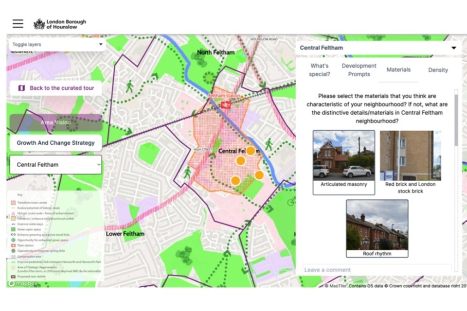
Residents could explore visions for different neighbourhoods through an interactive map. Image courtesy of London Borough of Hounslow.
Image description: Screenshot of the Hounslow interactive map showing neighbourhood areas and a panel where users can select local design characteristics.
Results and impact
A total of 52 people took part in the consultation, either through the tool or by email. Participation was low. The council noted several possible factors, including that the tool was in prototype form and that some residents still preferred to submit comments by email.
Among those who used the tool:
- most users were individuals
- older age groups were more strongly represented, with no responses from people under 30
- respondents valued the interactive maps
- workshops provided additional feedback from younger and disabled residents
What they learned
The pilot showed that:
- users tended to comment on their own neighbourhood rather than borough-wide codes, suggesting local relevance influenced engagement
- some content was harder to find or used less often, indicating navigation improvements were needed
- continuing to offer workshops supported engagement from younger people and disabled residents
- because the tool was still in prototype form, the council would need to refine it further to address technical issues raised by users
Future plans
Hounslow intends to further develop the Local Plan Maker tool so it can be adapted for a wider range of planning consultations. The council plans to improve the graphics and overall style of the tool and explore additional features to expand interactivity and make future consultations easier to manage.
Help us improve this case study by completing our short feedback form.
Useful resources
Explore tools and suppliers on the Digital Planning Directory.
Use the Digital community engagement toolkit for planning consultations.
Read guidance on using community engagement platforms in planning consultations.
Explore the Open Digital Planning community.
External links on this page are included to help users find relevant information. Their inclusion does not imply government endorsement of any organisation, product or service.