Basildon identifies 23% more urban housing sites
Basildon Borough Council used a digital mapping and site analysis tool to identify more urban housing sites and reduce processing time.
Estimated reading time: 7 minutes
Basildon Borough Council tested a digital approach to identifying development sites to support its local plan work.
- Outcome: Identified 23% more potential urban housing sites and reduced the time needed to process call for sites submissions.
- Technology used: LANDCLAN to assess sites and manage site data, and Commonplace to share site maps and gather public feedback.
This was a PropTech Innovation Fund round 4 pilot (2024) and describes what was tested at the time.
The planning challenge
The council needed to improve how it identified sites for housing as part of preparing a new local plan. In particular, it wanted to:
- identify more potential development sites within existing urban areas
- make better use of previously developed land
- reduce reliance on manual site visits and assessments where possible
- bring planning and council asset data together in one place
- improve transparency in how potential sites were identified
Around two thirds of Basildon borough is designated as Metropolitan Green Belt. When preparing a new local plan, elected members wanted to take a “no stone left unturned” approach to identifying development opportunities within existing urban areas.
The council needed a way to assess land across the borough within the local plan timetable. This was not achievable through traditional site visits and manual assessments alone.
What they did
The council tested an approach to identifying potential development sites across the borough’s urban area.
Setting up the digital site identification approach
The council tested LANDCLAN to analyse each land parcel in the borough using Land Registry boundaries and a set of standardised datasets.
These datasets covered factors such as planning policy, land use, flood risk, access to services and proximity to existing infrastructure. The council combined these with local datasets, including planning consents, planning applications, call for sites submissions and council-owned land.
Planning officers worked with the supplier to develop an approach for identifying sites using:
- absolute constraints, which removed land parcels where development would not be appropriate
- weighted criteria, which influenced how sites were scored
Officers reviewed initial outputs and refined the criteria to reduce the number of unsuitable sites. Once agreed, the approach was applied across all land parcels. This produced ranked results that could be reviewed and updated as data changed.
Publishing sites and gathering feedback
Using its existing public consultation platform, Commonplace, the council published an interactive map showing identified potential urban sites. Residents could view locations, rate their level of support and leave comments.
The pilot also supported closer working between planning, asset management and development teams. Bringing planning, land ownership and asset performance data into a single system helped officers focus on sites that were most suitable for development, including opportunities on underused council-owned land.
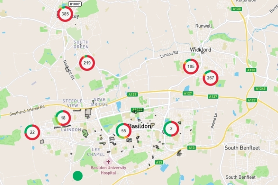
Image courtesy of Basildon Borough Council. The image may have been cropped for display purposes.
Image description: Basildon interactive map where users can comment and score specific locations.
Results and impact
At a glance:
- 23% increase in the number of potential urban sites identified
- reduced time spent processing call for sites submissions
- over 1,000 public comments received on urban capacity sites
- 42 council-owned sites identified with redevelopment potential
Identifying potential urban sites
The pilot resulted in a 23% increase in the number of potential sites identified within the urban area. The council reported that this provided clearer evidence of housing capacity and reduced the risk of double counting sites.
The council used LANDCLAN to review land in its ownership and identified 42 sites with potential for housing. Two of these sites later received planning permission.
Reducing time spent assessing sites
The council reduced the time needed to process call for sites submissions. Average processing time per site fell from around 12 minutes to under 1 minute.
Time spent analysing sites also fell by around half on average. Once the site identification criteria were set, LANDCLAN could reassess all land parcels in the borough by running a single report.
The council found that digital analysis could not fully replace professional judgement. Planning officers reviewed sites to validate results using aerial photography and street-level views within the tool. In some cases, site visits were still needed. Some constraints, including biodiversity value and features on unregistered land, were not fully captured by the data.
This combination of automated analysis and officer review helped the council identify sites more efficiently while maintaining oversight of which sites were suitable.
Public engagement
Publishing an interactive map of identified potential urban sites led to a significant increase in feedback. The council received 1,074 comments, compared with limited engagement in previous consultations.
The council also reported more engagement from working-age and younger residents.
What they learned
The council found that:
- automated site scoring needs testing and refinement to avoid unsuitable sites ranking highly
- digital analysis must be combined with officer review and, in some cases, site visits
- data quality and integration are critical when using historic and local datasets
- some constraints, such as biodiversity value on long-unused urban land, are difficult to identify through standard datasets alone
- basic use of the tool required relatively limited GIS (geographic information system) training
The pilot also supported closer working between planning, asset management and development teams by providing a shared view of site data. Planning officers were able to access site information and generate standard reports with minimal training, reducing reliance on specialist GIS staff.
Future plans
Basildon has continued to use LANDCLAN to assess land identified through the call for sites and to support work on potential site allocations for the emerging local plan.
The council plans to use the tool to assess whether land in employment areas could support more intensive development and to support decisions in response to recent changes in national planning policy.
Help us improve this case study by completing our short feedback form.
Useful resources
Explore tools and suppliers on the Digital Planning Directory.
Read guidance on site identification and assessment using digital tools.
Explore the Open Digital Planning community.
External links on this page are included to help users find relevant information. Their inclusion does not imply government endorsement of any organisation, product or service.