Coding process: 3A Guidance for area types
This section describes guidance for area types that authorities should consider when creating design codes or guides.
These issues will need to be addressed for each area type. If the code is not using an area type approach, these issues will need to be considered for the whole code area.
We have used the town centre, urban neighbourhood and suburban area types as examples in this section. These are purely illustrative, and the suggested settings are illustrative and should not be taken as a policy suggestion.
This section should be read in conjunction with the guidance notes and the relevant sections are indicated for each issue.
The issues covered are:
- Movement: The guidance relating to the network of streets, active travel, and public transport relates to all area types. The key variables being the street types and parking arrangements.
- Nature: Most of the guidance on nature also applies to all area types, the exceptions potentially being open space standards, sustainable drainage systems (SuDS) and urban greening.
- Built form: This is the main issue that varies by area type including density, grain, building line and height.
- Identity: The design of buildings will vary by area type and may vary to a lesser degree within area types.
- Public space: The character of each type of street will vary by area type and will be impacted by the character of the wider area.
- Use: The opportunities for intensification, mix of uses and housing types mix of uses, and active frontage will all vary by area type.
- Homes and buildings: Guidance of privacy distances and garden/balcony sizes may vary by area type.
- Resources: Guidance on net zero solutions, climate resilience and adaptation where this is specific to Area Types and varies from whole code area guidance.
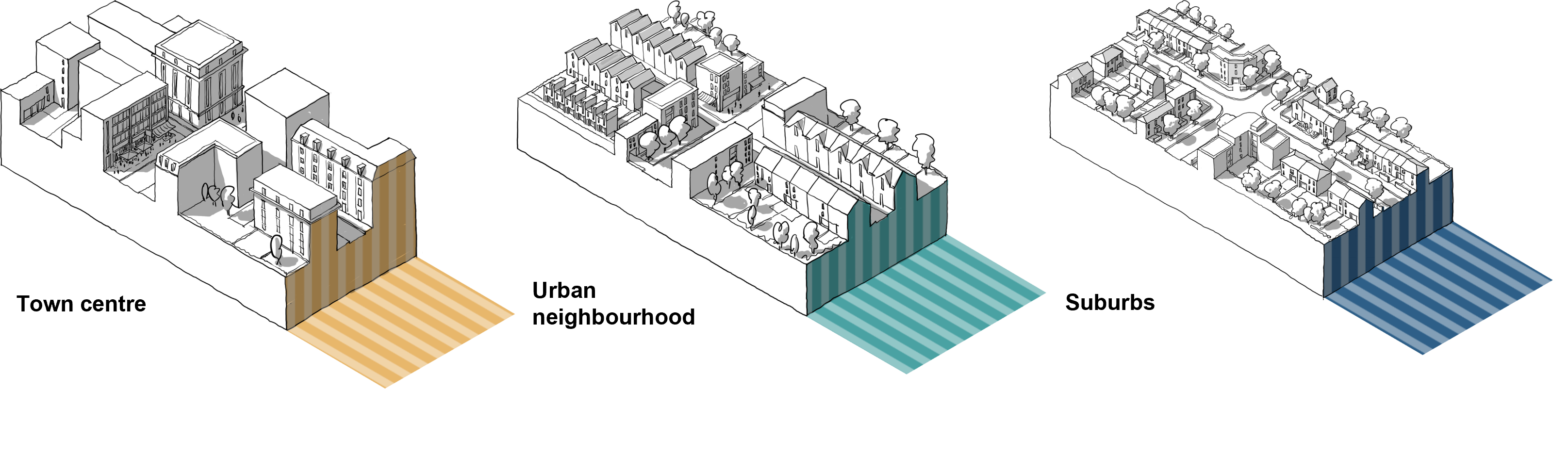 Figure 12. Illustrative Area types
Well-designed places should be accessible and easy to move around. This can be achieved through a connected network of streets, good public transport, the promotion of walking and cycling and well-considered parking and servicing. Detailed information is provided in Guidance Note Code Content: Movement. The following might require area type-specific guidance:
i. New streets
All new streets should be safe and overlooked and correspond to their role in the street hierarchy and area type - e.g. a primary street in an urban centre will have a different character to one in a village. See M.1.iii - Street Hierarchy.
ii. New junctions
Guides might specify traffic signalled junctions on high streets and less formal, unmarked junctions on local streets. See M.2.ii - Junctions and Crossings.
iii. Car parking
Standards for all uses will be set in the local plan, but the ways in which they are accommodated will vary. See Fig 13 and 14 and M.3.i - Car parking.
iv. Cycle parking
Standards will be set in the local plan and specified in codes according to context. e.g. public cycle parking on a high street or private cycle storage in a dwelling. See M.3.ii - Cycle parking.
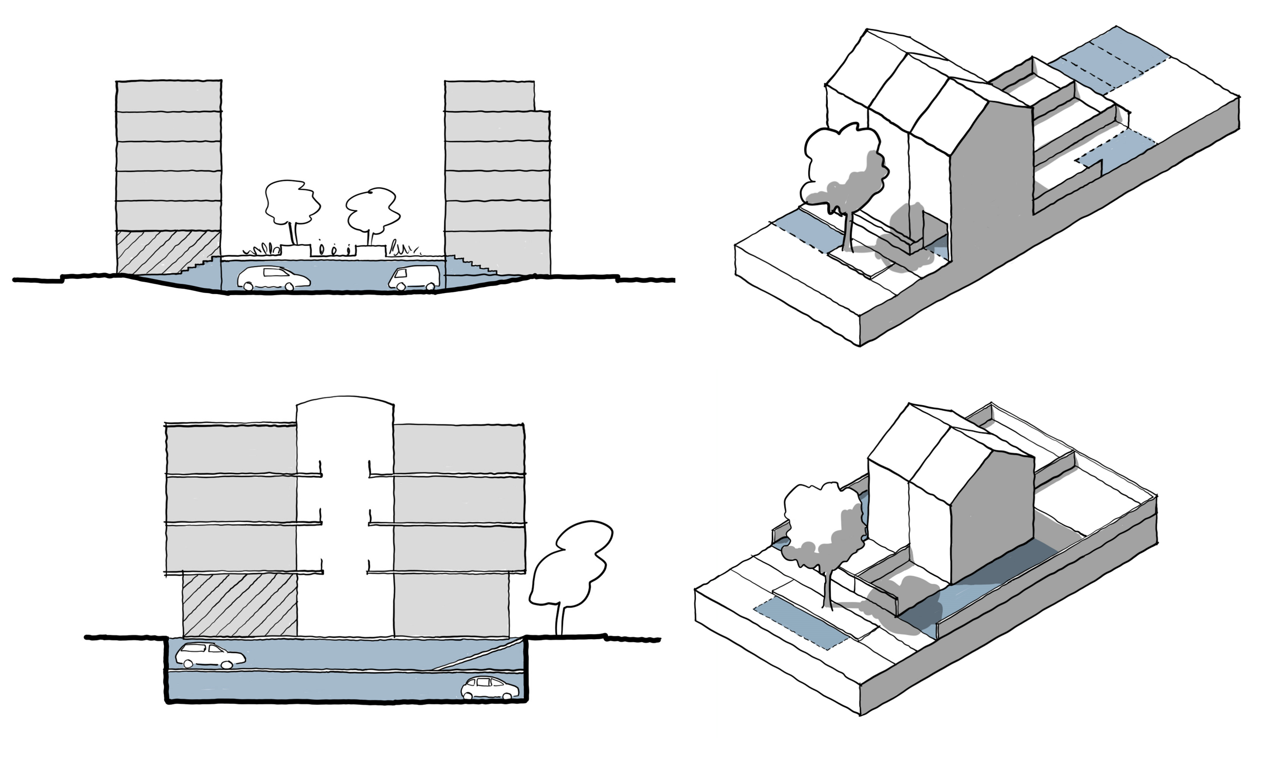 Figure 13. Parking Arrangements
Town centre
New provision should be at basement, semi-basement or decked. New surface parking might be prohibited where there is a clear and compelling justification.
Urban neighbourhood
Likely to be on-street (for visitors), within the building (townhouse), or to the rear in gardens or parking courts.
Suburbs
Likely to be in-curtilage, at the front (with suitable landscape features) or to the side of the property, so cars don’t dominate the street. Visitor parking is likely to be on-street.
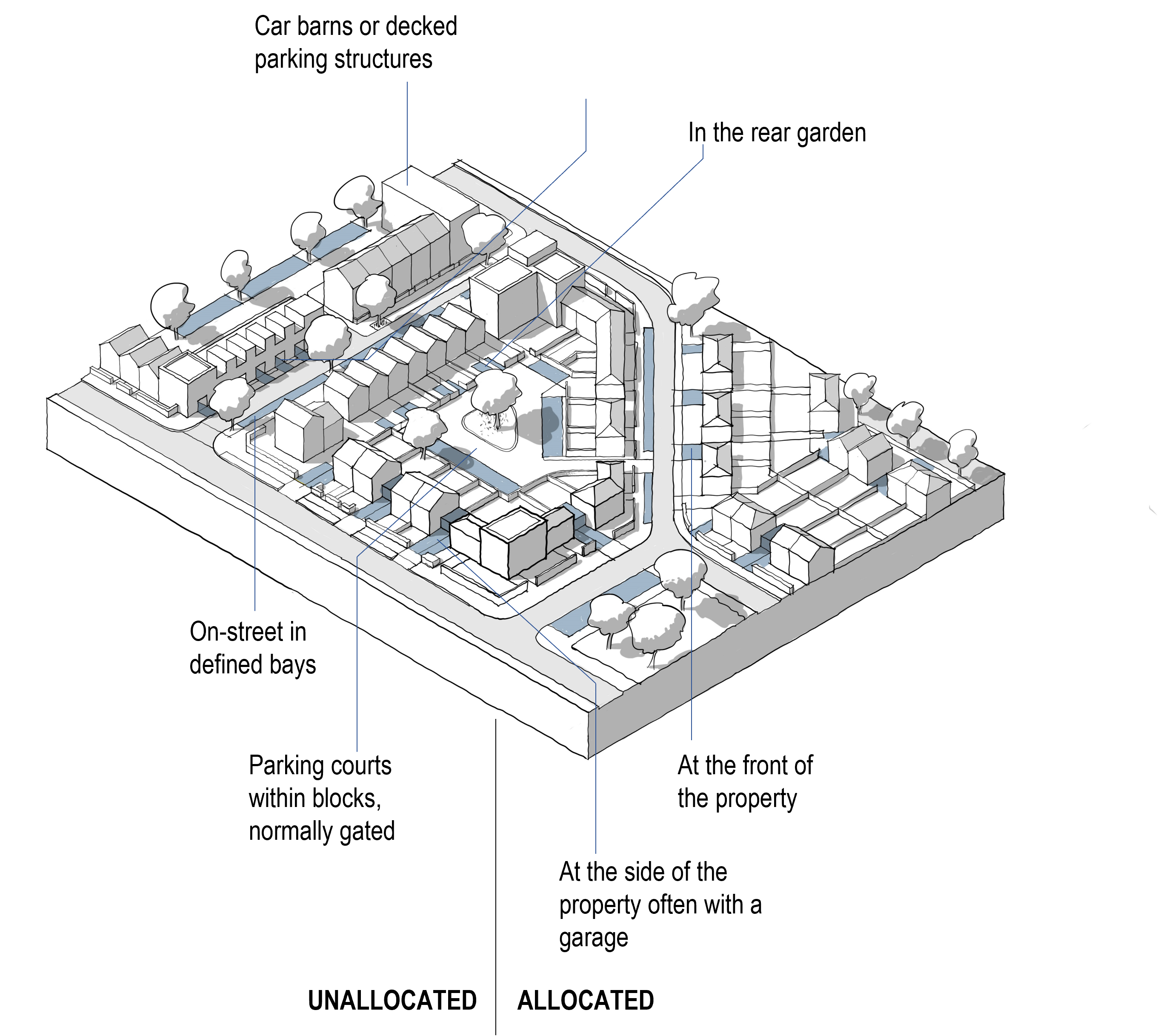 Figure 14. Residential Parking Options
[Alt text: This is an annotated 3D line drawing of a residential neighbourhood, annotated with different residential parking options. They are split into allocated and unallocated solutions. The unallocated solutions include:
- car barns or decked parking structures
- on-street in defined bays
- Parking courts within blocks, normally gated
The allocated parking solutions include:
- Within an integrated garage in a town house
- In the rear garden
- At the front of the property
- At the side of the property, often within a garage ]
Nature and green spaces should be woven into the fabric of our villages, towns and cities. This provides benefits in terms of health and wellbeing, biodiversity, climate and flood mitigation and can connect nature to wider surroundings. Detailed information is provided in Guidance Note Code Content: Nature. Most of the guidance on nature will be general. The following might require area type-specific guidance:
i. Open spaces
Open space standards may vary, with less open space in smaller, accessible pockets required in town centres and more generous provision in suburbs. Key principles for integrating green space can be adapted for different contexts. See Fig 15 and N.1.iii - Open Space Design.
ii. Sustainable drainage systems (SuDS)
In urban areas, these may be integrated into the built environment, while suburbs could make use of natural/landscape features. See Fig 16 and N.2.ii - Sustainable Drainage.
iii. Green infrastructure
Urban area types might include requirements for planned open spaces, SuDS and other green infrastructure such as green roofs and walls, lower density areas for more natural green spaces and habitats and utilise urban greening factor tools. See N.3.ii - Planning for Biodiversity.
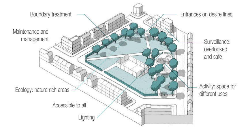 Figure 15. Open Space Design: Key principles of how green space can be integrated to improve the environment and liveability, and which can be tailored to different contexts.
[Alt text: This is an annotated 3D line drawing of an open green space surrounded by buildings. The space has the feel of a neighbourhood park with trees and a playground area. The annotations indicate key elements of good open space design and are as follows:
- Boundary treatment
- Entrances on desire lines
- Surveillance: overlooked and safe
- Activity: space for different uses
- Lighting
- Accessible to all
- Ecology: nature rich areas
- Maintenance and management ]
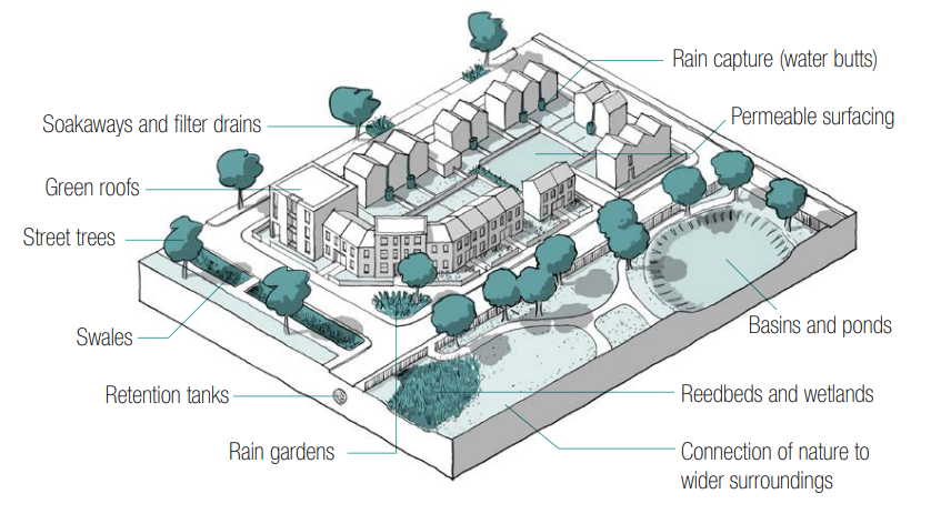 Figure 16. SuDS toolkit: A variety of tools that can boost sustainable drainage in different contexts.
[Alt text: This is an annotated 3D line drawing of a residential block surrounded by a variety of green and blue spaces. The annotations highlight a variety of sustainable drainage solutions and include:
- Rain capture (water butts)
- Permeable surfacing
- Basins and ponds
- Reedbeds and wetlands
- Connection of nature to wider surroundings
- Rain gardens
- Retention tanks
- Swales
- Street trees
- Green roofs
- Soakaways and filter drains ]
Built form refers to the three-dimensional arrangement of buildings, blocks, streets and spaces. This will form the core of the design code and the settings for each element of built form will vary considerably by area type. Detailed information is provided in ‘Guidance note code content: Built form’.
i. Density
Codes should define density ranges, which are likely to be higher for town and local centres and lower in suburbs (illustrative example below) Mixed use schemes can be calculated on a pro-rata basis. See B.1.i Density.
Town centres: >200d/ha
Urban Neighbourhoods: 60-120d/ha
Suburbs: 30-50 d/ha
ii. Plot ratio
Calculated by dividing the gross floor area of the building by the area of the plot, plot ratios along with site coverage should be used alongside good urban design principles to regulate the density of mixed-use and non-residential uses (example below) See B.1.i Density.
Town centres: >2
Urban neighbourhoods: >1
Suburbs: <0.5
iii. Whether buildings join
How buildings relate to neighbouring buildings has an important impact on urban form. Likely variation in guidance by area type is shown in Fig 17. See B.1.ii Whether Building Join.
iv. Grain
The pattern of plots in an urban block/area. New development should, where possible, be sympathetic to the existing grain. The grain is likely to be finer (smaller plot size) in town/local centres and coarser (larger plot sizes) in suburbs. See B.1.iii Building Types and Forms.
v. Public/private
New development should create a clear separation between the public fronts of buildings and the private rears within the centre of development blocks. This is normally achieved using blocks. Likely variation by area type is shown in Fig 18. See B.2.i Blocks.
vi. Edges of development
Codes should demonstrate how the edges of plots are treated and how this relates to the landscape and wider context.
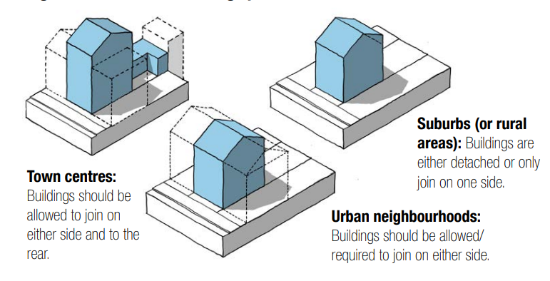 Figure 17. Whether buildings join.
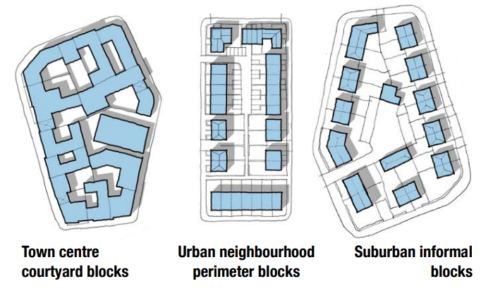 Figure 18. Typical Block Types.
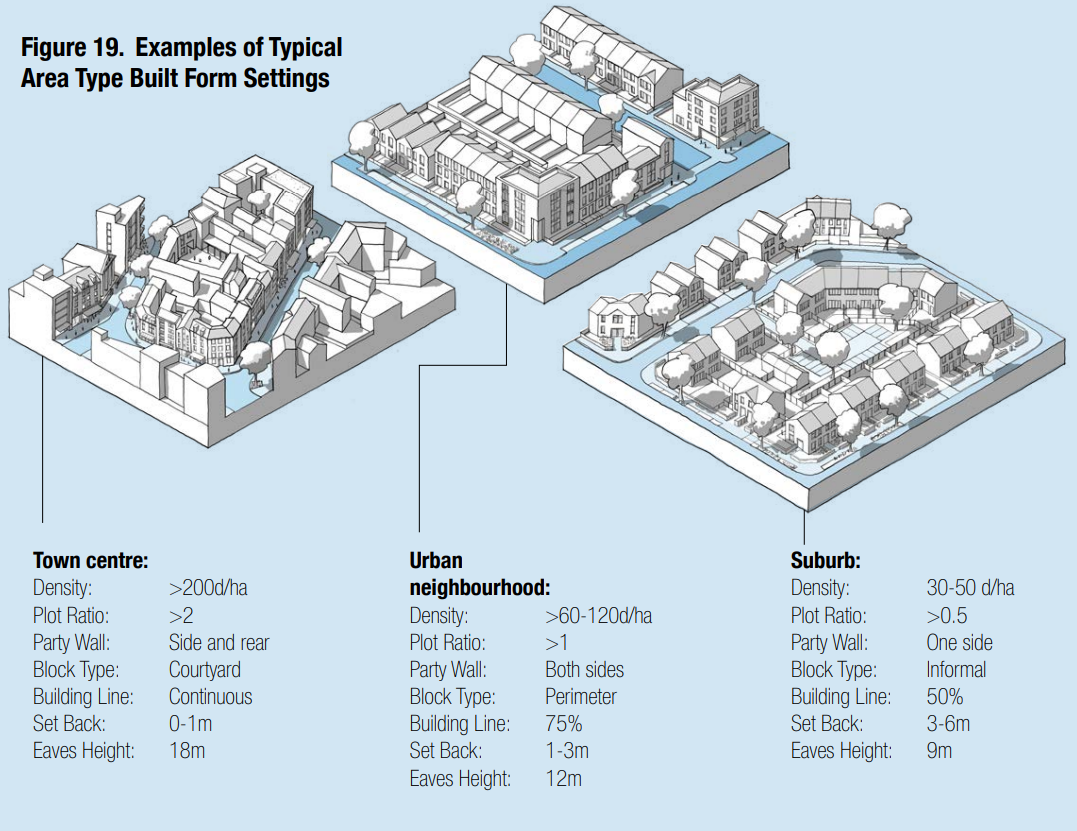 Figure 19. Examples of Typical Area Type Built Form Settings.
[Alt text: Series of three 3D line drawings illustrating how different built form settings can be combined to create area types with distinct forms and characters. The images show a higher-density town centre environment, a medium density urban neighbourhood and a lower density suburb. The following captions provide a list of settings for each example.]
vii. Building line
The building line s created by the primary front face of buildings along a street and is a key element of design codes. New development should follow the established building line where it exists. Where there is no building line (for example on the periphery of a town centre or a development site), codes should set one. Coding for building lines can include:
- Variation: The extent to which buildings can be set forward or back from the line.
- Projections: Allowance for elements such as balconies.
- Compliance: The percentage of the building line that should be occupied by development.
- Set-back: The distance that buildings are set-back from the pavement.
Figure 20 shows how building line guidance might change by area type.
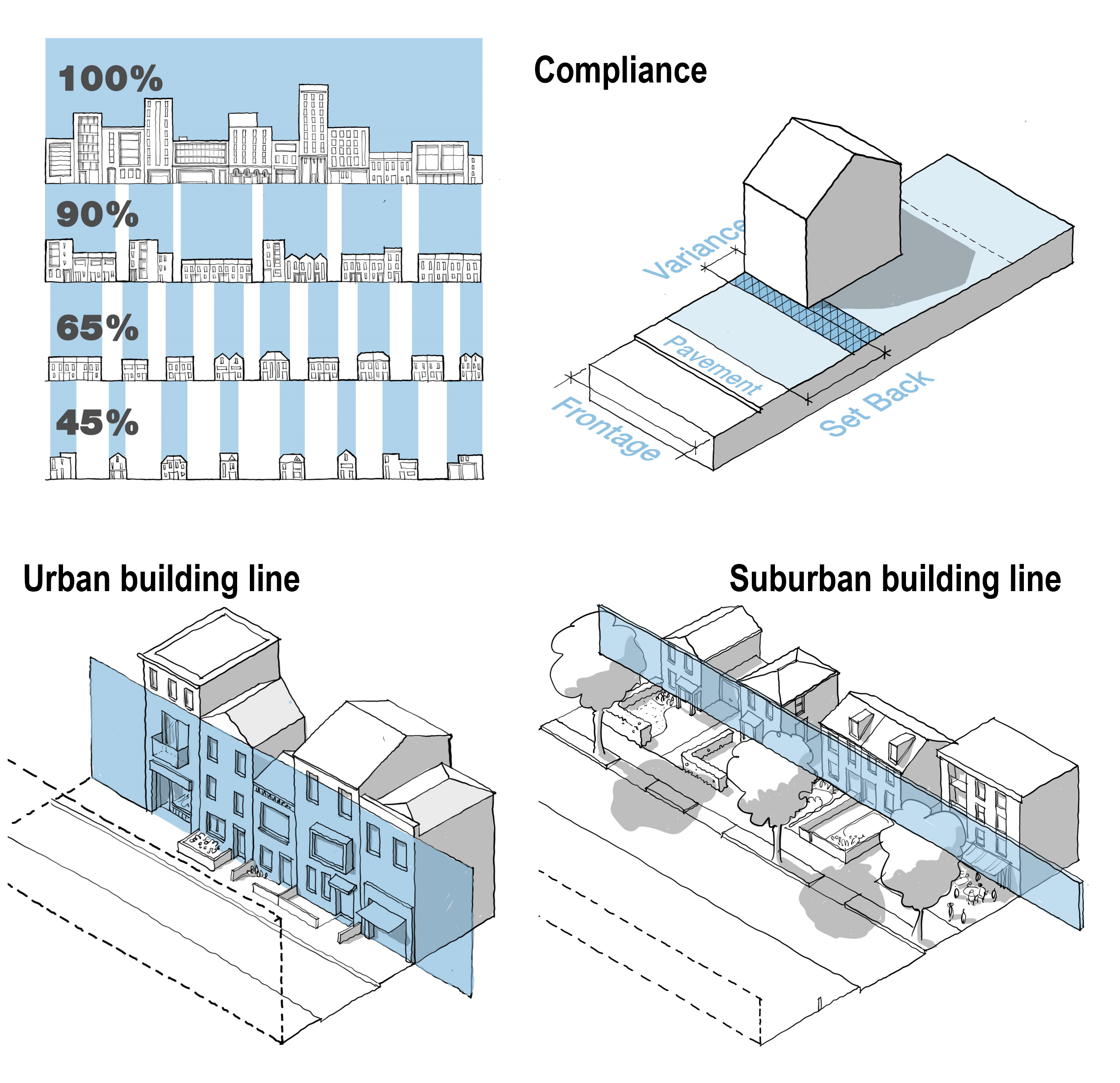
Figure 20. Building Line: In urban areas, the building line should preferably be continuous and the set-back limited. In suburban and rural areas the set-back may be greater and there will be much more variation.
viii. Heights
The height of buildings will be a key element of design codes. This is regulated through eaves heights, total heights and exceptions. Figure 21 shows how heights might vary by area type. See B.2.iii Height.
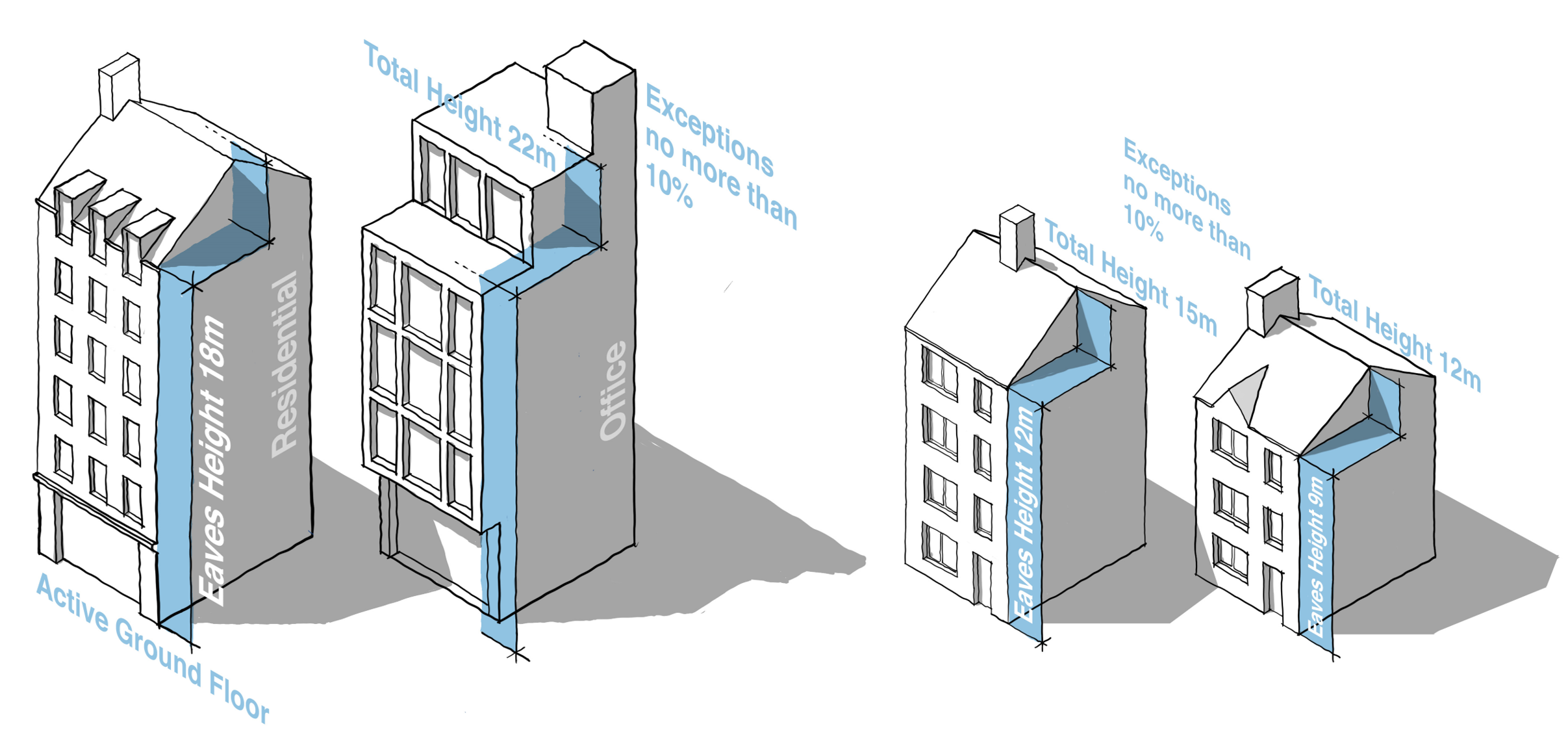 Figure 21. Heights.
Town centre heights: An example showing an eaves height of 18 meters and a maximum height of 23 meters, allowing 5 storeys of housing or 4 storeys of offices over active ground floor uses.
Urban neighbourhood and suburban heights: An example showing an eaves height of 12 meters and 9 meters with maximum height of 3 meters above this, allowing for 4 or 3 storeys of housing.
ix. Tall buildings
In many areas codes will need to make provision for taller buildings. Some city area types may include limited restrictions on height. However, in most area types codes can either indicate zones where taller buildings can be considered or indicate the circumstances where exceptions to the height coding might be considered See B.2.iii Height.
The identity of an area comes not just from its built form and public spaces but also from the design of its buildings. This is not about architectural style, but about key principles of building design. All new buildings should take into account the architectural character and materials of the surrounding area. In local design codes guidance on identity will vary considerably from area to area, informed by the worksheet at the appendix of the guidance notes, and may include guidance on the following components. Detailed information is provided in Guidance Note Code Content: Identity, in particular Section I.2.i Building Design Principles.
i. The base of the building
The ground floor may be treated differently to the upper floors to create a relationship with the street. It may use different materials and include active uses, especially in the context of a town/local centre.
ii. Thresholds
Entrances should be emphasised in the architectural treatment of façades. This can include porches, recessed doors and other entrance features.
iii. Boundaries
The treatment of boundaries has a significant role to play in creating character. Figure 23 shows how guidance on boundaries might change according to area type.
iv. Roofscape
Variation in eaves height and roof forms will vary based on the character of the local area. Historic town centres, villages and suburbs tend to have a variety of roof types whereas a Georgian inner neighbourhood, for example is typically uniform.
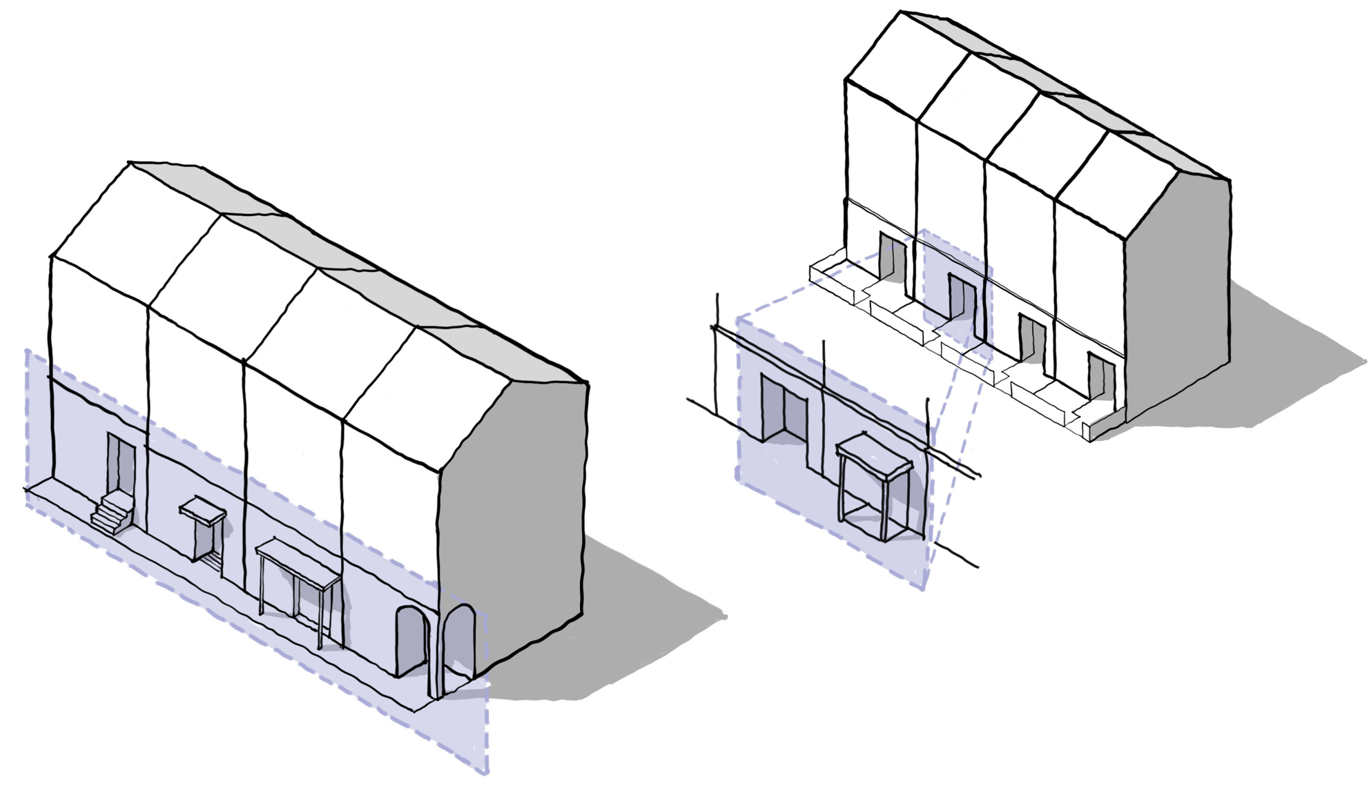
Figure 22. Base/Ground Floor.
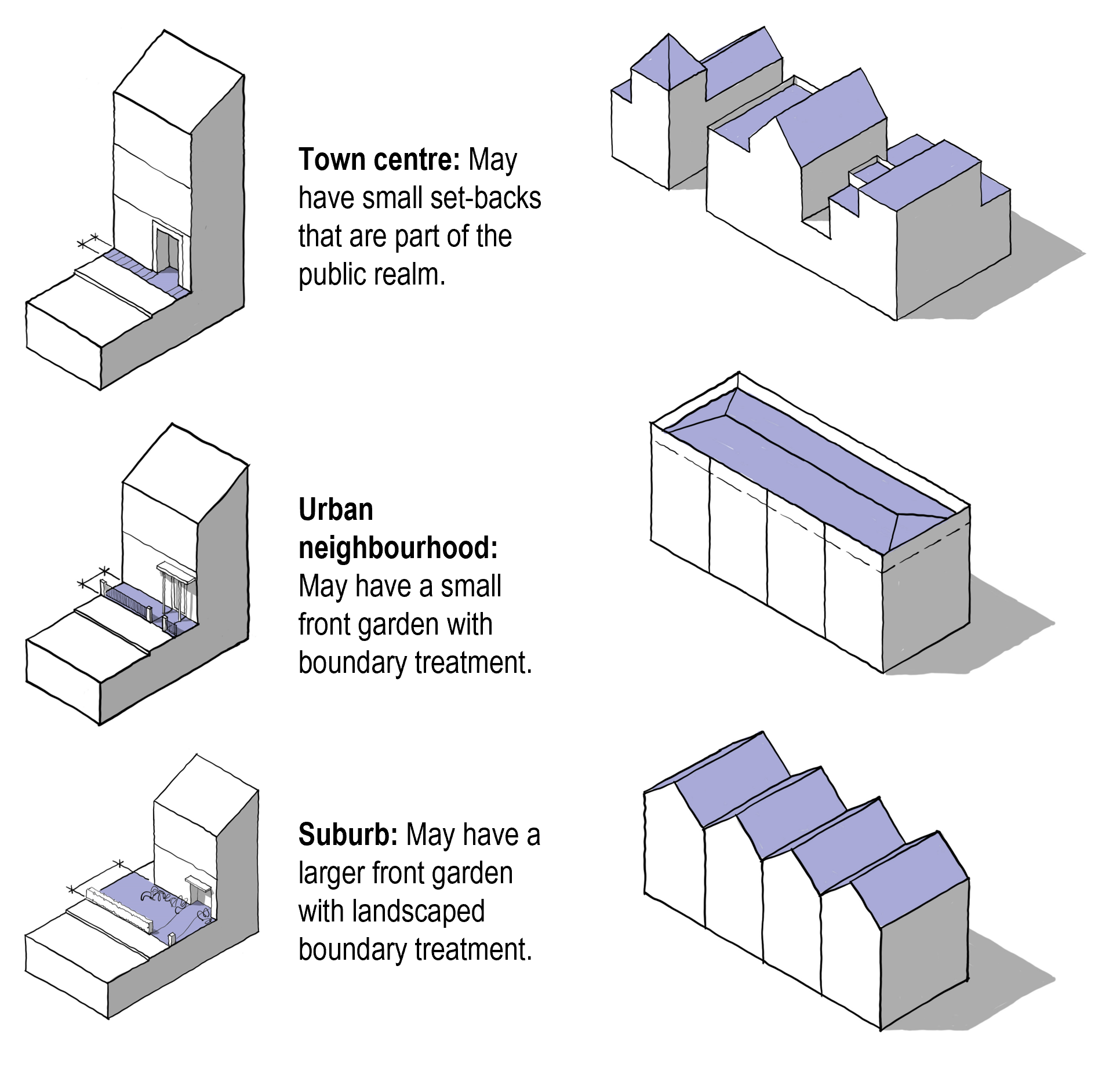
Figure 23. Boundaries. Figure 24. Roofscape.
[Alt text: Fig 23 shows a series of three 3D line drawings illustrating the ways that boundary treatments might vary by area type, using a single building as an example. The following captions explain the likely variations:
- Town centre: May have small set-backs that are part of the public realm.
- Urban neighbourhood: May have a small front garden with boundary treatment.
- Suburb: May have a larger front garden with landscaped boundary treatment.
Fig 24 shows a series of 3 3D illustrative line drawings showing how roofscapes might vary by area type. The first shows a varied roofscape, the second a more uniform flat roofscape and the third a uniform pitched roofscape with gables facing the street. ]
v. Windows
Guidance may be provided on the design of windows based on the character of the area. The proportion of glazing may vary with city centres allowing fully glazed façades but elsewhere the glazing ratio might be limited to 35%. Guidance can also direct the orientation of the windows and the depth of reveals.
vi. Variation in frontages
Guidance may be provided on the level of articulation such as set-backs, porches, balconies and bays, especially if the character of such features are particular to the existing area. Fig 26 shows how frontage variation can create different characters.
vii. Detailing
Guidance may be provided on the use of colour, quality of materials and detailing, drawn from the surrounding context, e.g. an area might be characterised by the use of a particular type of brick. A degree of complexity will ensure that buildings are attractive from a distance and close-up. Fig 27 shows how depth and interest can be created with window details.
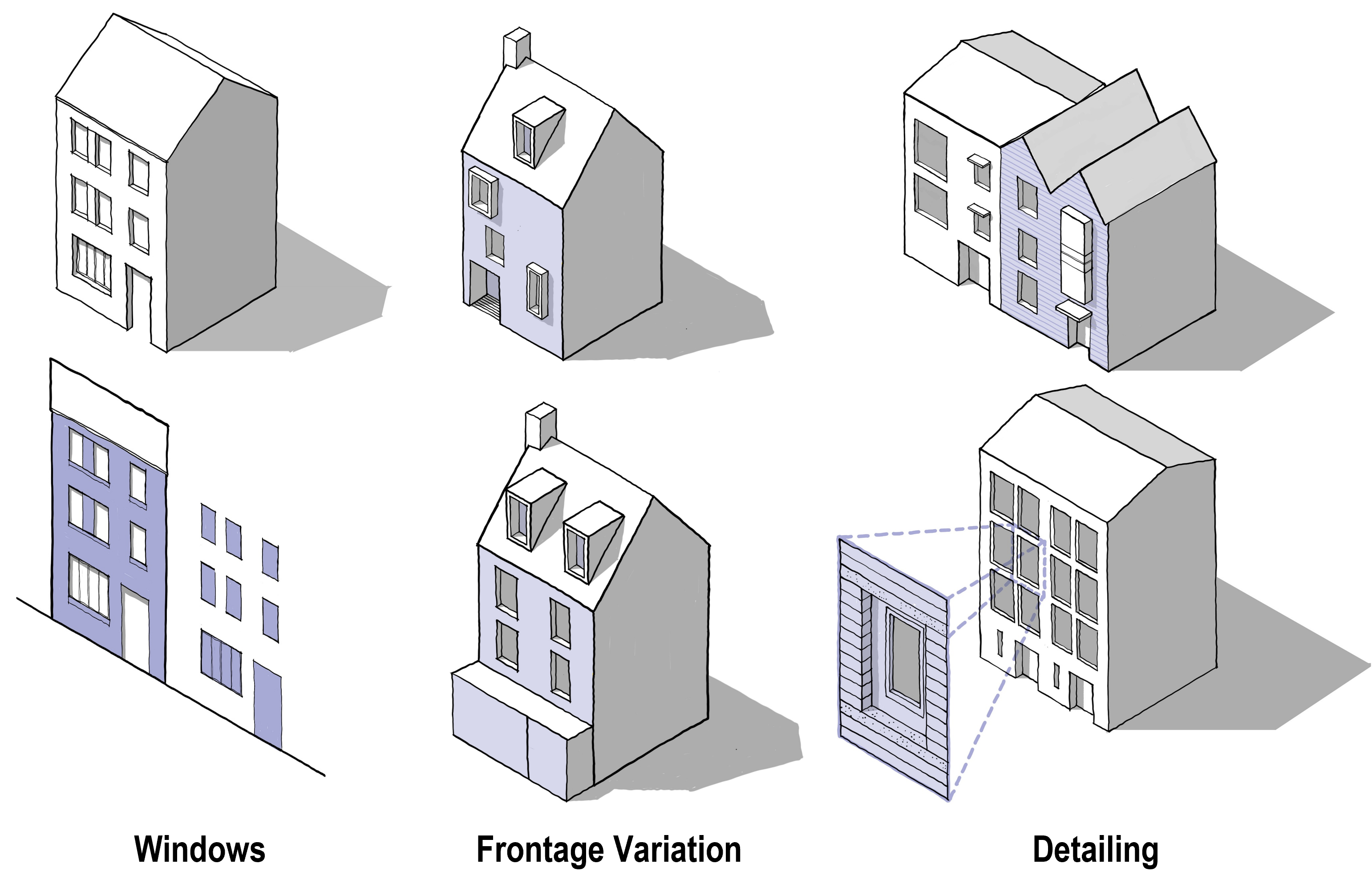
Figure 25. Windows. Figure 26. Frontage Variation. Figure 27. Detailing.
[Alt text: Fig 25 is a 3D line drawing of a house with glazed windows and a door, accompanied below by a diagram showing the resulting ratio of glazed surfaces to facades.
Fig 26 is a 3D line drawing of two houses, illustrating how changes to the variation in frontages can change the character of two buildings with broadly the same underlying form. One shows windows placed in an irregular pattern across the facade, while the other is more ordered and traditional.
Fig 27 shows a 3D line drawing of two buildings, illustrating how depth and interest can be created with window details. The lower image highlights how detailing can create interest when viewed both from a distance and close up. ]
Tall building design principles
Tall buildings may be permitted in certain area types which will require guidance on their design. Key principles are set out below. (See I.2.i Para 49 for more detail.)
Top
Consider the impact on the skyline. Services need to be concealed, and both the street views and the long views need to be considered.
Form
Should be well-proportioned in terms of slenderness when viewed from all frontages.
Materials
The use of materials to be consistent and simple.
Base
Consider following the building line at street level, which may require a base to the building that is scaled to the surrounding buildings.
Public realm
Public spaces around the base to be generous, well designed and contribute positively to the local context.
Entrance
The entrance needs to clearly marked.
Micro-climate
Needs to be considered in terms of overshadowing and wind. It may be necessary to protect the surrounding public realm from down draughts.
Active frontage
If required by the design code the ground floor of the tall building needs to include active frontages.
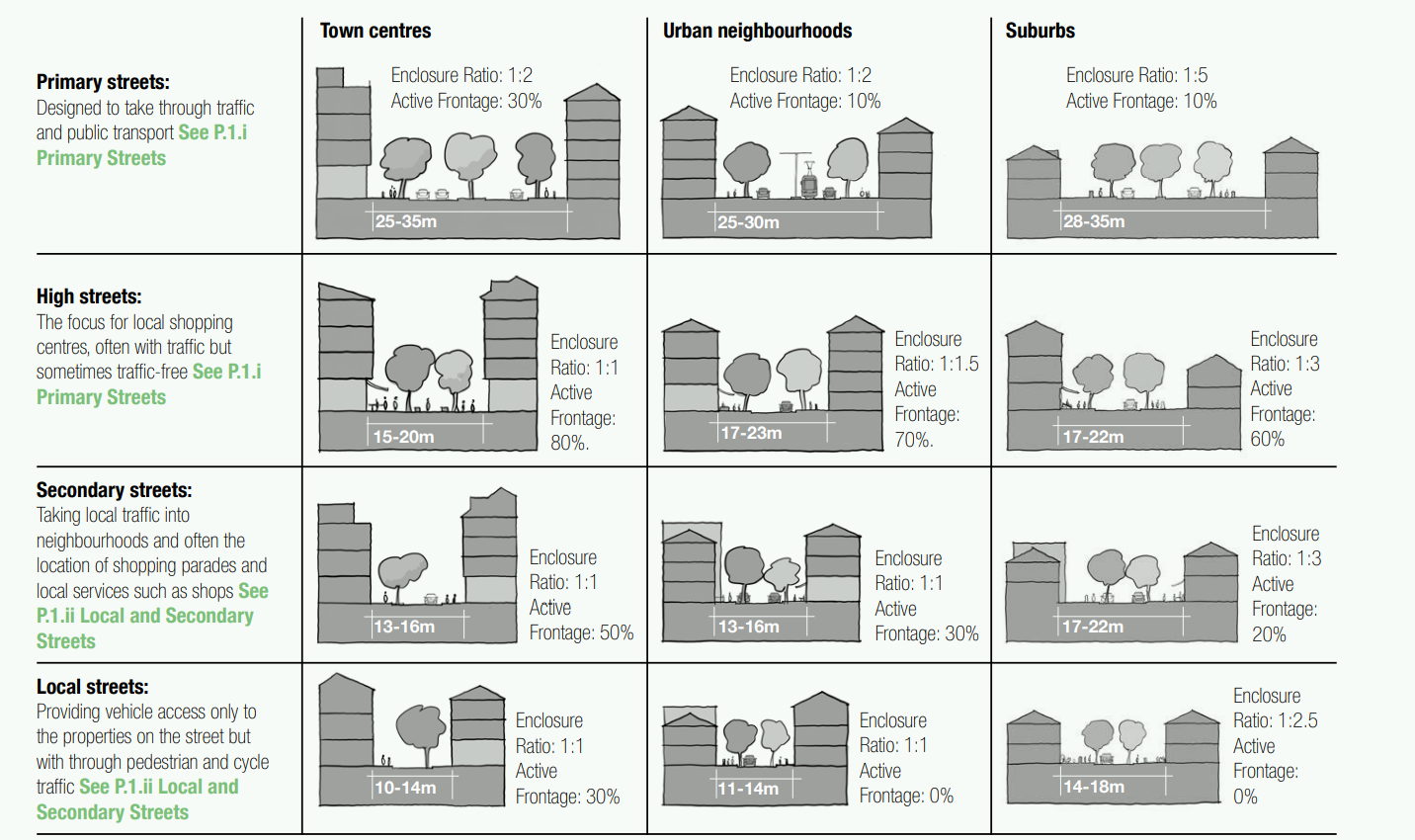
Figure 28. Street Matrix.
[Alt text: Fig 28 is laid out as a table, showing how different levels of the street hierarchy would vary by area type. The types of streets are listed down the left hand side, and the area types are listed across the top. In each instance an image showing an example street section is included, along with examples settings. The reader will read each street type in order, going through the settings for each area type before moving down the street hierarchy. ]
The quality of public space is partly about the way it is designed and partly about the way it is enclosed by well-proportioned buildings. Detailed information is provided in Guidance Note Code Content: Public Space. Streets are a component of public space which will vary considerably by area type. Section P.1 details different types of street, showing how urban form can be coordinated with the guidance in Manual for Streets.
i. Streets
New development should contribute to the character of the street on which it is located. This character will be different depending where the street sits in the street hierarchy and the context in which it is located. Figure 28 illustrates how the characteristics of a street might vary by area type and position on the street hierarchy. A similar diagram could form part of design code guidance at local level. See P.1 Streets.
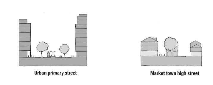
Figure 28. Street Matrix: An illustrative example showing how street character and form might change by area type and by position on the street hierarchy.
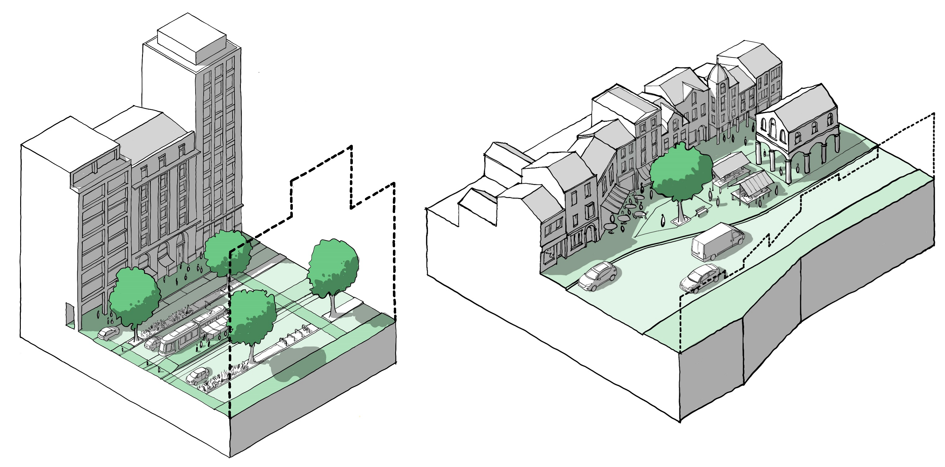
Figure 29. Street Types: The guidance notes contain a range of examples of the design of street types from major cities to market towns and villages. The excerpt below shows how the identity of a primary street can vary considerably depending on context; from an urban primary street with tall buildings and a public transport hub to a market town high street with mid-density buildings and a market square.
Sustainable places include a mix of uses that support everyday activities including space to live work and play. Detailed information is provided in Guidance note code content: Use. The following components are likely to vary by area type.
i. Intensification
Making more efficient use of land. In urban areas this might mean infill development or development of airspace. In suburban areas it might mean garden development. See U.1.i Efficient use of land.
ii. Mix
A mix of uses will likely be a requirement in centres, will be encouraged in urban neighbourhoods and may be permitted but not required in suburbs. See U.1.ii Mix.
iii. Active frontage
Ground floor uses that create interest and activity. Requirements for such uses will likely be higher in town/local centres than suburbs and will also vary by street type. See U.1.iii Active Frontage.
iv. Housing
The mix of housing tenures and types will vary with apartments being the norm in town centres and a greater mix being required in urban neighbourhoods and suburbs. See U.2. Housing Mix.
v. Schools
Guidance on schools will likely be based on similar principles of integrating with the existing built form, but urban areas are likely to require more dense solutions. See U.3.i Schools.
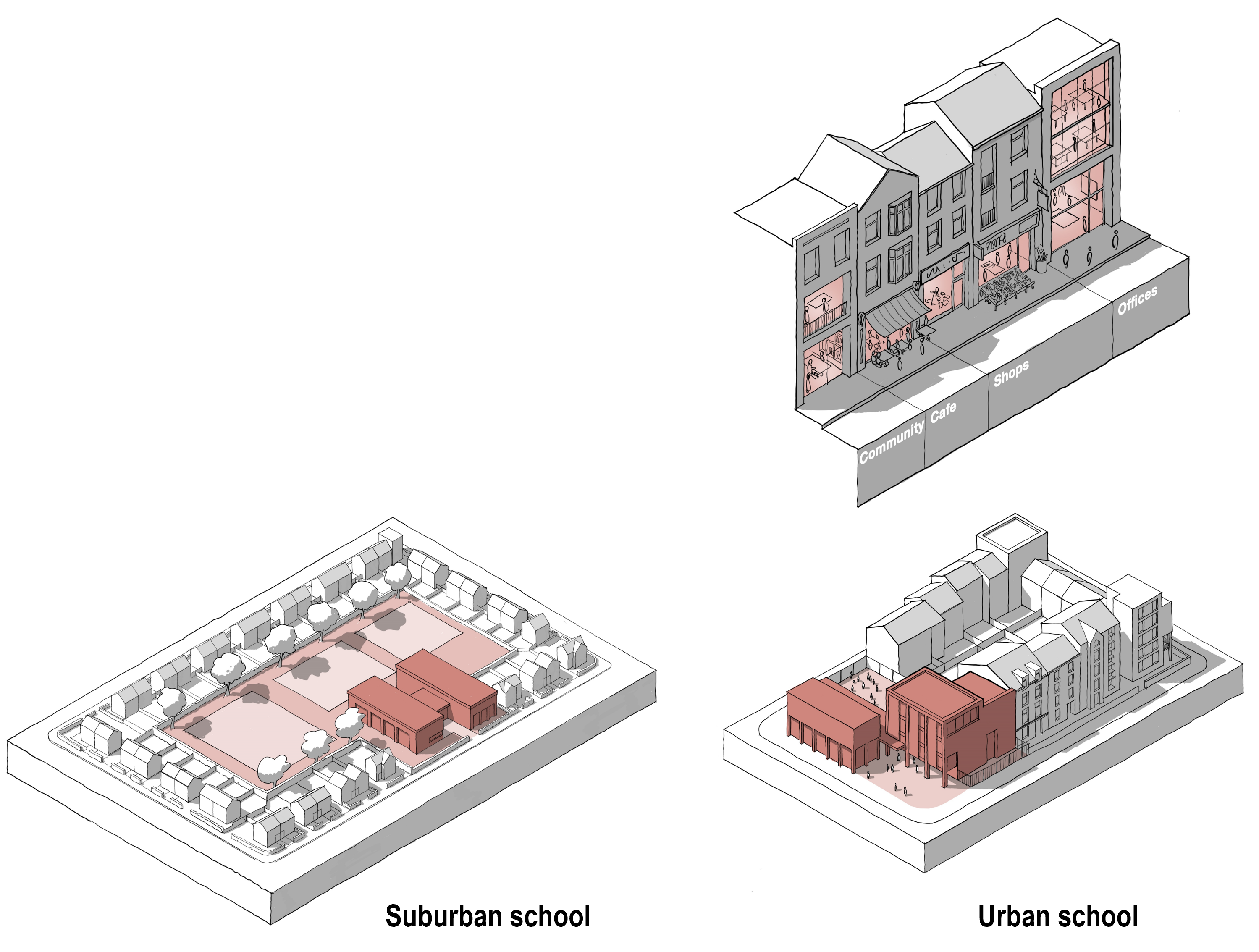
Figure 30. (Right) Active Frontage: An example of uses that can create activity at the level of the street, e.g. community facilities, cafes and restaurants, shops and offices. Figure 31. (Below) School Design: Both the suburban (left) and urban (right) schools complete the block and address the existing building line, but differ in height and density according to their context.
[Alt text: Fig 30 is a 3D line drawing of a section of a street, illustrating a number of different types and configurations of active frontage, including a community use, cafe, shops and offices.
Fig 31 contains a pair of 3D line drawings showing how a school can be integrated into a block in different contexts. The first image shows a suburban school and the second shows a higher density urban school. ]
Well-designed homes and buildings are functional, accessible and sustainable. Detailed information is provided in Guidance Note Code Content: Homes and Buildings. The majority of issues are unlikely to vary by area type, the elements that may vary are detailed here.
i. Lighting, aspect and privacy
In more urban areas there may be a need for more lighting and shorter privacy distances might be acceptable, while in suburban areas lighting might be more minimal and privacy distance might be greater. See H.2.i Lighting Aspect and Privacy.
ii. Gardens and balconies
Codes might specify minimum sizes for gardens and balconies to improve well-being and amenity. In more urban areas this might be smaller, while in suburban areas larger garden spaces might be specified. See H.2.iii Gardens and Balconies.
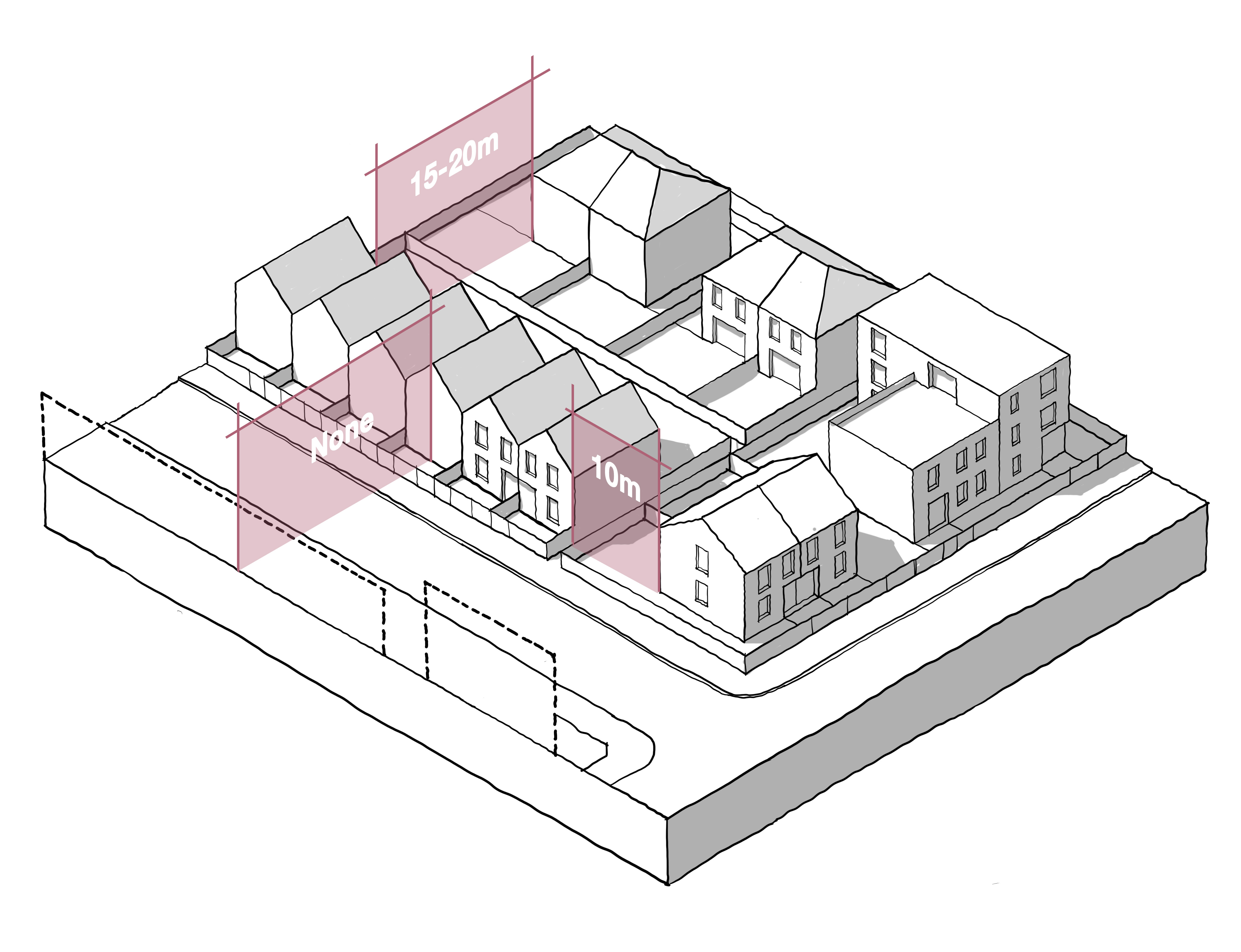
Figure 32. Privacy Distances: These are the distances between dwellings to ensure private amenity, in particular the distance between the windows of habitable rooms. The illustration shows how minimum distances might be specified.
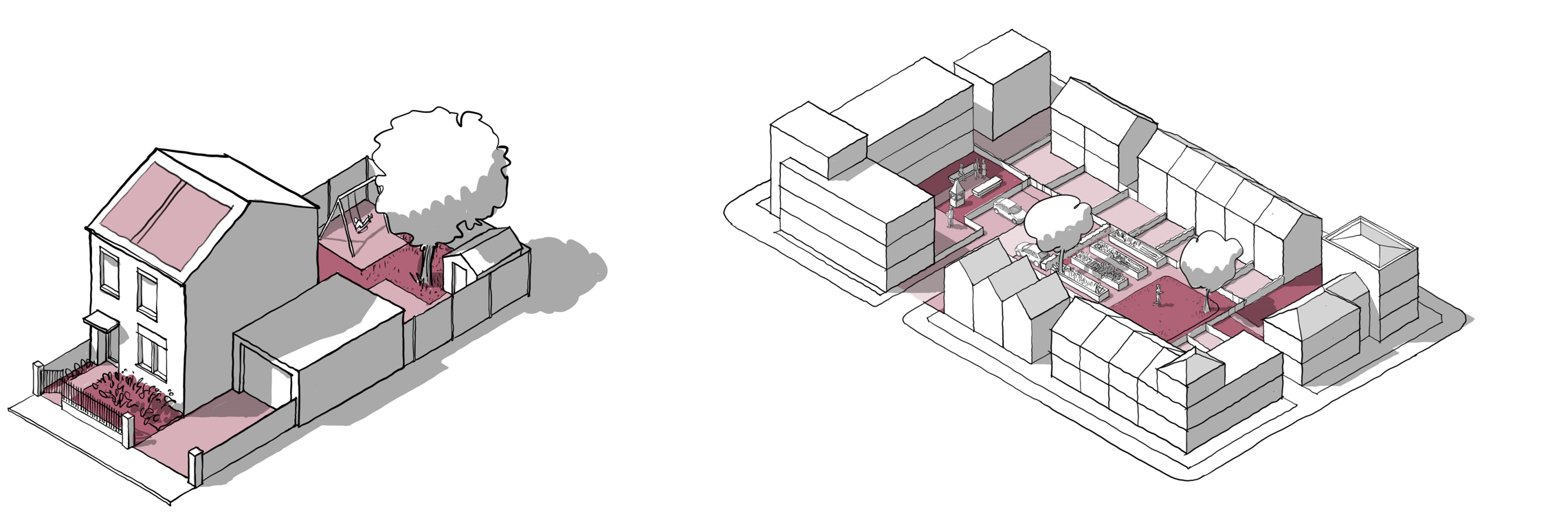
Figure 33. Gardens: Illustration showing how private gardens, shared gardens and parking might be specified in a courtyard layout.