National Model Design Code: part 2 - guidance notes (html accessible version)
Updated 14 October 2021
Applies to England

© Crown copyright 2021
This publication is licensed under the terms of the Open Government Licence v3.0 except where otherwise stated. To view this licence, visit nationalarchives.gov.uk/doc/open-government-licence/version/3 or write to the Information Policy Team, The National Archives, Kew, London TW9 4DU, or email: psi@nationalarchives.gov.uk.
Where we have identified any third party copyright information you will need to obtain permission from the copyright holders concerned.
This publication is available at https://www.gov.uk/government/publications/national-model-design-code/national-model-design-code-part-2-guidance-notes-html-accessible-version
Code content
Introduction
1. The following guidance note sets out possible contents for a design code, modelled on the ten characteristics of well-designed places set out in the National Design Guide.
2. It is based on the key characteristics of context, movement, nature, built form, identity, public space, and use. Other sections dealing with homes and buildings, resources and lifespan provide important considerations in achieving design quality and should be used to inform the content of local plans, design codes or guides depending on local circumstances. These themes are interconnected, and users of this coding process should be mindful about the ways that they interrelate.
3. When following this process of selecting and setting parameters, it is essential that decisions are being made directly in response to the analysis and visioning exercises outlined in the main document. This guidance note sets out the potential content of a design code that can be developed into clear and, where possible, measurable guidance, subject to the context and type of development. The content outlined provides both a framework and some sample content from which design codes can be developed and adapted, to address the particular context to which the code will be applied.
4. Each theme is divided into subsections, and in each case, we describe the parameter/ issue, why it is important and how it might be used in a design code. In some cases these parameters / issues will vary by area type, while others will be applied equally across the local area. Not all parameters are relevant to every circumstance. Flexibility in local design codes can be introduced by setting an acceptable range for a parameter or not coding for it at all. Effective design codes are:
- Simple, concise and specific and;
- Rely on visual and numerical information rather than detailed policy wording.

Figure 1. Structure
[Alt text: The image shows the structure of the guidance notes, with miniature pages set out in two columns of five, showing the ten sections of the document. Each section is given a different colour, shown by a strip down the side of each page:
- Mid tone purple: Context.
- Dark blue: Movement.
- Dark green: Nature.
- Light blue: Built Form.
- Light purple: Identity.
- Light green: Public Space.
- Light orange: Uses.
- Dark orange: Homes and Buildings.
- Dark raspberry: Resources.
- Dark purple: Lifespan. ]
Context
Introduction
5. The National Design Guide states that an understanding of the context, history and character of an area must influence the siting and design of new development. This context includes the immediate surroundings of the site, the neighbourhood in which it sits and the wider setting. This includes:
-
C.1: An understanding of how the scheme relates to the site and its local and wider context.
-
C.2: The value of the environment, heritage, history and culture.
C.1 Character studies
6. Character includes all of the elements that go to make a place, how it looks and feels, its geography and landscape, its noises and smells, activity, people and businesses. This character should be understood as a starting point for all development. Character can be understood at three levels; The area type in which the site sits, its surroundings and the features of the site.
C.1.i Defining Area Types
7. The Design Code applies to a set of area types as described in Section 1. These are areas of similar character that allow elements of the design code to be set out depending upon which area type a development is within. This is illustrated in Figure 2, and the settings would be determined locally.
8. The aim of the design code is to work towards a vision of what each area type needs to be. The starting point will, be to undertake a series of area type studies through a combination of site visits, historical analysis and work with maps. The settings for each of the area types need to be based on a) an analysis of the existing character of these areas and b) a visioning exercise. A standard work sheet (See Appendix) can be used for each area type to systematise data collection.
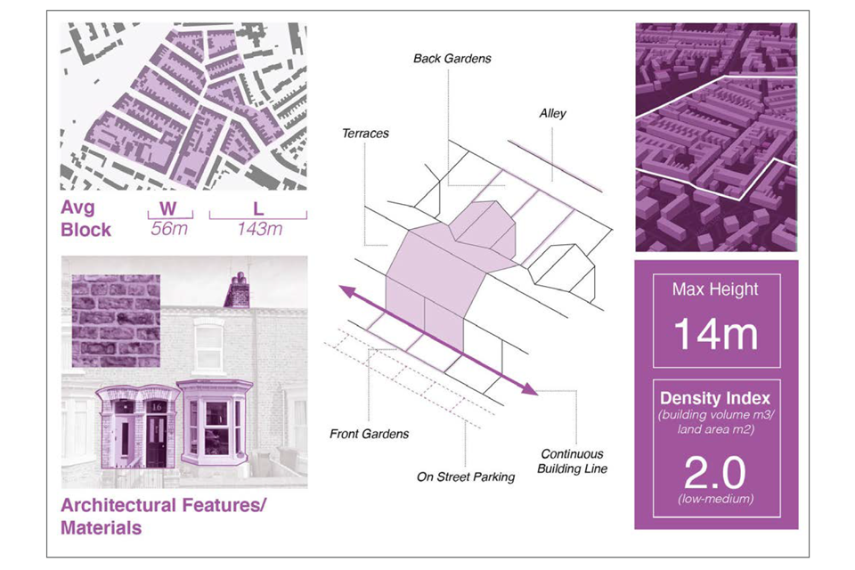
The image shows an example context map for the area surrounding a fictional development site in an imagined mid-sized town. The image relates to the preceeding text which outlines what components and features should be included.
[Alt text: The image is an infographic showing extracts of what an Area Type Worksheet could look like. The contents include:
- a diagram showing the average block size.
- photos of key architectural features and materials (in this case, red brick and prominent bay windows).
- A drawing showing the building line, set back and garden arrangement.
- A 3D plan showing heights and density.]
C.1.ii Site context
9. It is necessary to undertake a context study of the area surrounding the site and the wider area for a full understanding of the place in order to respond positively to its distinctive features. Well-designed buildings need to respect and enhance their built and natural environment surroundings whilst addressing local constraints, the vision for its area type and responding positively to new issues such as innovation and environmental sustainability.
C.1.iii Site assessments
10. Developments need to respond to the site and the opportunities that are there to develop local character and distinctiveness, as shown in Figures 3 and 4.

The image shows an example context map for the area surrounding a fictional development site in an imagined mid-sized town. The image relates to the preceeding text which outlines what components and features should be included.
A study of the surrounding area looking at the following:
- The network and hierarchy of surrounding streets.
- Public transport.
- Walking and cycling routes. Notable local buildings.
- The characteristics of the local community. Local shops and facilities.
- Views, vistas and landmarks, such as places of worship. Visual amenity and views.
- The grain of the area; variation in built form, street scene and roofscape.
- Landscape and natural features such as hedges, green spaces, trees and woodland.
- Boundary features such as walls, fences and hedges.
- Water features including groundwater, rivers, lakes, canals, flood risk and other water features.
- Topography and geology.
- The local building vernacular, architecture, proportion, façade pattern and proportion.
- Architectural details and materials such as the use of brick, stone or render for walls, slate or tile for roofs etc.
- Colours, textures, shapes and patterns.

The image shows an example context map for the area surrounding a fictional development site in an imagined mid-sized town. The image relates to the preceding text which outlines what components and features should be included.
- Access points: How these relate to local movement patterns, rights of way and routes to shops and schools.
- Orientation: The sun path and how it affects the site.
- Topography: Changing site levels.
- Drainage: Run-off and opportunities for water features and SuDS.
- Existing structures: Existing buildings and walls with opportunities for retention.
- Existing utilities: Existing infrastructure and services.
- Ground conditions: Contamination and fill.
- Noise and Air Quality: Traffic noise and fumes and disruptive uses.
- Landscape and ecology: Natural features and habitats such as trees, hedgerows, and other mature vegetation contributes to a sense of place and needs to be retained and enhanced.
- Water: Ponds, lakes and watercourses that can be incorporated as natural features including to possibly open-up and naturalise watercourses.
C.2 Cultural heritage
11. Well-designed development adds a new layer to the history of a site while enhancing and respecting its past, with the expectation that new development will be valued for its heritage in the future as heritage assets are today.
C.2.i Historic assessment
12. A study of the sites’ history can be done by in-depth analysis of the place, including historic maps, as set out in Historic England’s Understanding Place guidance. These include details such as former uses, natural features, cultural features, urban form, street patterns and place names. They can help explain features of the site and can be used as inspiration for new development, such as reinstating historic streets.
C.2.ii Heritage assets
13. Development should always take account of heritage assets within or close to the site as defined in the NPPF.
14. The character and distinctiveness of a place is created by the richness of the buildings that have been built up over time. Not just the individual buildings or monuments, but how they relate to each other and how they have contributed to the evolution of the place has a whole.
15. The presence of such historic character, either directly on the site, or nearby, should always be seen as an opportunity to add value to any development by helping to provide inspiration.
Figure 5. Historic map assessment: A historic assessment with plans from the 1800s, 1900s and the present day.
[Alt text: A series of three figure ground diagrams, where the buildings are coloured in black and the rest of the features are left blank. The three maps show the evolution of the urban form of a town from the 1800’s, through the 1900’s and up to the present day. The first image shows fine grain development in regular plots, taking up only half to two thirds of the frame. In the second image the whole frame is filled with buildings and we can see the arrival of a large train station. In the final image some of the fine grain development has been replaced with larger blocks and there are empty spaces where the built form has been fractured.]
Check list: Context
Local design codes should consider:
C.1 Character studies.
- Creating an area type matrix showing how the contents of the code relate to each area type.
- The preparation of context studies to inform the design of individual sites.
C.2 Cultural heritage.
- Historical assessments that can be used as a foundation for new development.
- Heritage assets and conservation area details that may influence the form of development and the relationship of these issues to the design code.
Movement
Introduction
16. The National Design Guide says that a well-designed place is accessible and easy to move around (p22-25). For movement, this means:
- M.1: A connected network for all modes of transport;
- M.2: Active travel and;
- M.3: Well-considered parking, servicing, and utilities infrastructure for all modes and users.
A series of model design parameters may be coded for each of these, as identified on the following pages.
M.1 - A connected network
17. A connected network and hierarchy of routes for all modes of transport form the circulatory system of any settlement and its design will determine how easy and safe it is to get around for all and how it links destinations to public transport. These issues are particularly important when coding for large sites but may also influence local design codes for smaller infill sites and their physical connectivity.
M.1.i The street network
18. The street network is important because it sets a long-lasting framework for moving around. In most cases, it will outlive the buildings it originally served.
19. A connected street network is one that provides a variety and choice of streets for moving around a place. It is direct, allowing people to make efficient journeys. Direct routes make walking and cycling more attractive and increase activity, making the streets feel safer and more attractive. Connected street networks form the basis of most of our beautiful and well-used places. They are robust, flexible, consider environmental impacts and have been shown to stand the test of time.
20. In a well-connected network, each street has more than one connection to another street. This applies both within a development or local area and in relation to streets outside it. Culs-de-sac are only found at the tertiary level of street type (see P1:3) for accessing development rather than for wider movement.
21. Permeability for different users, such as cars or delivery vehicles, can be controlled by measures within the street space, for instance, to prevent through movement or limit access to certain times of the day.
22. Consideration needs to be given to safety and security issues in respect of street layouts and footways, especially in areas in which a large number of people gather or pass through. Passive surveillance of the street, good lighting and high levels of street activity are desirable to deter criminal behaviour and to ensure people feel safe and secure using the street at all times.
23. Connected street networks may be linked to coding for street hierarchy, street types and public spaces (see P1).
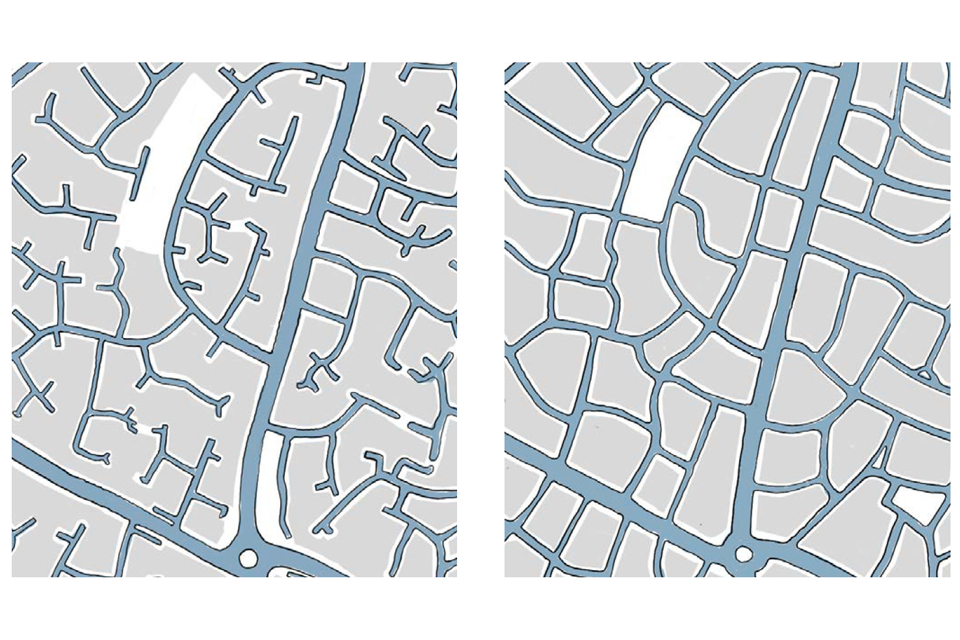
Figure 6. Connected Street Networks: A connected network of streets reduces walking distances.
[Alt text: Two images showing a simplified top down plan of a residential neighbourhood. The first image shows a series of cul-de-sacs or dead ends branching off from the primary and secondary streets - a poorly connected street network. The second image shows the same place, but with all the smaller streets connecting into one another - a connected network, which will be easier to navigate on foot.]
M.1.ii Public transport
24. Access to public transport is key to providing people with choice for everyday journeys beyond the immediate neighbourhood, such as to town centres, schools and employment locations. Good access to public transport helps reduce reliance on the private car.
25. A site or location has good public transport accessibility when dwellings have a public transport stop within walking distance.
26. The distances that people are prepared to walk from their dwelling to reach public transport are determined by the nature and quality of the public transport service, how attractive and safe the walk feels, and the total length of their journey. Generally, people are prepared to walk further to a railway station or tram stop (10 minutes) than to a bus stop (5 minutes).
27. Accessibility to public transport may be linked to other coding on mix of uses, local amenities, housing types, densities, and parking arrangements.

Figure 7. Walking Isochrone Around Public Transport Stops:
Walking distances can be assessed approximately by drawing circles to show the potential catchment area of new or existing public transport. It is important to take account of the actual walking distance (walking isochrone) which will be smaller, particularly where there are barriers to movement – for instance lack of adequate lighting and wayfinding, absence of green spaces, lack of good-quality and accessible footways, high-traffic routes such as busy road or a railway line.
[Alt text: This is a top down plan showing “isochrones” in dark blue shading. An isochrone illustrates the distance that can be walked outwards from a central point in a finite period of time, for example, 5 minutes. The image illustrates the text for figure 8 which talks about walking isochrones around public transport stops, and the barriers to movement that can make them smaller.]

Figure 8. PTAL Plan: An example of a public transport accessibility level plan for Croydon.
[Alt text: This is an extract from London’s interactive online “PTAL Plan” which shows the level of public transport accessibility for different places using a graduated colour system. This extract focuses on Croydon and the surrounding area. Dark red colouring over the centre of Croydon shows good public transport accessibility, while outer areas coloured in blue indicate poorer provision of public transport.]
M.1.iii Street hierarchy
28. The design of the street network plays an important role in determining how it is used. Different streets play different roles in a place depending on the movement upon them, the built form and uses around them and the design of the street space itself, including any natural features, landscaping, lighting and wayfinding.
29. A design code may categorise the streets in a network as different street types. Each street type has a distinct function in terms of both movement and place that will vary according to the area type. Movement includes all modes, walking, cycling, public transport and motor vehicles.
30. Manual for Streets editions 1& 2 define common street types and functions, which this code seeks to align with. These street types include multifunctional streets and spaces; arterial routes and high streets; relief road/ring road; boulevards; high streets and residential streets. All have different place and movement functions. The street hierarchy below includes these street types together with other street types that may form part of a design code.
31. Coding may also define the range of street types that are appropriate for a local area or large site. Some common street types associated with this street hierarchy are set out in the Public Space section. All street types should enable safe and secure movement for everyone, including mobility impaired people, visually impaired people, and people with non-visible disabilities.

Figure 9. Street Hierarchy: A typical neighbourhood street hierarchy. All of these streets would include frontage access.
[Alt text: This is a highly simplified top down plan of a residential area, showing a number of different types of street in different widths and strokes of dark blue lines. The image illustrates the following text on street hierarchy, which describes different types of street and their role within a neighbourhood:
-
Primary street: Arterial, ring road or relief road with dedicated lanes for cycles and public transport, where possible.
-
High Street: Primary or Secondary street that acts as a focus for retail and other services.
-
Secondary Street: Mainly carry local traffic and provide access into neighbourhoods; they are often the location of schools and community facilities and may also be residential streets in themselves.
-
Local Street: Residential streets with managed traffic flows to prioritise active travel. They provide access to homes and support active travel, social interaction and health and wellbeing.
-
Tertiary street: These are used for servicing or for access to small groups or clusters of homes. They can be lanes, mews courts, alleyways or cul-de-sacs.
-
Multi-functional streets and other spaces: High Streets and secondary streets are at the centre of public life and support a wide range of activity. They can prioritise pedestrian and cycle movement while making it easy to get to their edges and beyond by public transport.]
M.2 Active travel
32. ‘Active travel’ refers to non-motorised and sustainable forms of transport, primarily walking and cycling. Prioritising active travel is about making walking and cycling easy, comfortable and attractive for all users, so they are seen as genuine choices for travel on local journeys. Coding for active travel is based on the user hierarchy from Manual for Streets. This sets out that in designing streets, the needs of pedestrians and cyclists should be considered first, then public transport, service and emergency vehicles and only then motor vehicles.
M.2.i Walking and cycling routes
33. Coding should reflect the aim that walking and cycling should be the first choice for short local journeys, particularly those of 5 miles or less.
34. For local journeys, this means creating continuous, clear, relatively direct and attractive walking and cycling routes both within a large site and into the surroundings. Following desire lines can help make routes clearer. Good sightlines aid wayfinding. They need to be well-lit, well-surfaced and maintained, and overlooked by buildings, as people feel safer on streets and in spaces where there are other people around.
35. Streets should be designed to be inclusive and cater to the needs of all road users as far as possible, in particular, considering the needs that may relate to disability, age, gender and maternity.
36. This is relevant to all street types. Designing a street so that everyone can use it benefits the whole community. Accessibility needs to be designed in from the start, as a ‘golden thread’ running through the scheme. This includes considerations such as minimum footway widths, placement of street furniture, frequency and type of crossing points, and so on, forming a basic part of the design process. Walking and cycling routes are also linked to coding for street types, parking and public spaces and through green infrastructure routes.

Figure 10. Low Traffic Neighbourhoods. On existing streets, Low Traffic Neighbourhoods preserve a connected street network for walking and cycling but prevent rat-running through traffic. This promotes walking and cycling and reduced car use. However, care is needed to ensure that displaced traffic doesn’t cause problems on neighbouring streets beyond the neighbourhood.
[Alt text: Two illustrative photographs.
The first shows a shared surface street in Thicket Mead, Midsommer Norton. The view looks down a paved road fronted onto by two storey houses. There is a level paved surface, with pavements distinguished from the central shared space with different paving and bollards.
The second shows a road in Waltham Forest that has been redesigned to give pedestrians and cyclists higher priority. The street has been remodelled, with much wider pavements, integrated street trees and a thinner strip of road surface at the same level as the pavement. The street is busy with pedestrians, who are walking both on the pavements and on the tarmac strip. A lady with a push-chair walks in the foreground of the image.]

Figure 11. Cycle Routes: Cycles should be separated from vehicles where possible.
[Alt text: This is a line drawing of a street section, showing how cycle lanes can be separated from the road. Reading from left to right it shows:
- A raised pavement with two figures walking.
- A cycle path at a lower level with a cyclist riding along.
- A generous gap at a raised level.
- A road at a lower level, with a car driving along it.]
M.2.ii Junctions and crossings
37. The way that streets join to each other and the way that people are able to cross streets and access points all have an important influence on walking and cycling.
38. The choice of junctions also influences where built form may be positioned and so the quality of the street as a public space.
39. All junctions and crossings need to be safe, convenient and attractive for all users.
40. Formal crossing facilities may be used on all street types, but may be particularly appropriate on primary streets and high streets. Siting a crossing on the pedestrian or cycle desire line will help to promote active travel and reduce accident risks by enabling a direct route, where people are more likely to use designated crossings. Manual for Streets sets out further detail on different types of crossing that can be appropriate.
41. Design codes may define appropriate junction types to manage vehicular priority and permeability on a connected street network and to promote active travel.
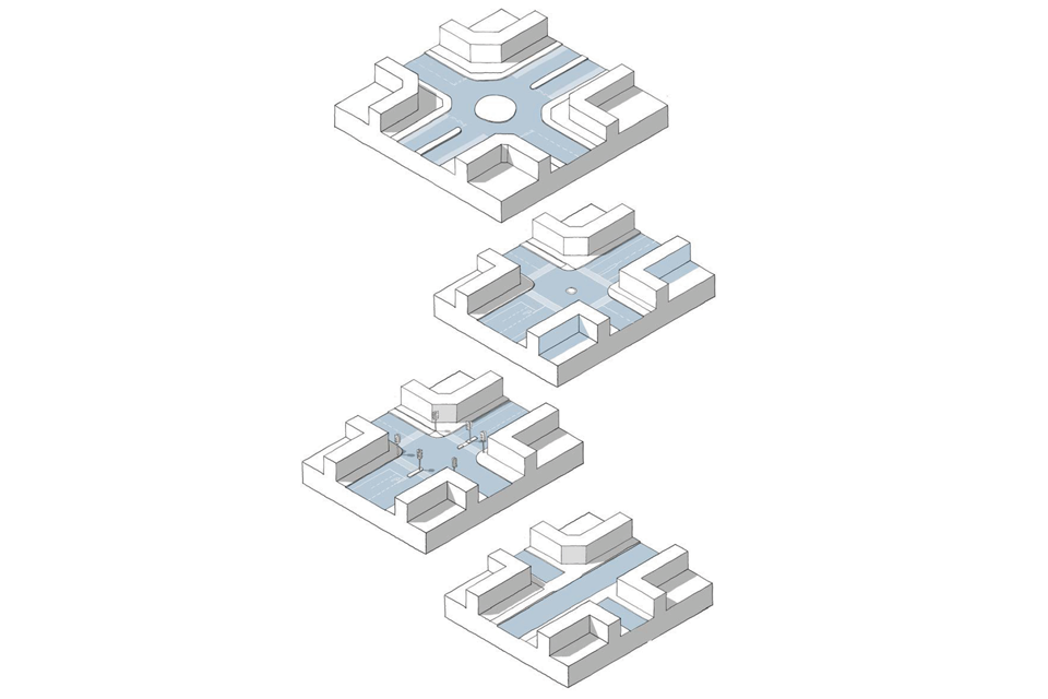
Four illustrative 3D line drawings showing different types of junction. The following text describes what is being illustrated in each case:
Roundabouts: Maintain traffic flows and speeds but do not provide well for cyclists and pedestrians and require more land than other junction types.
Mini Roundabouts: Manage traffic priority on junctions between primary, secondary and high streets in the built-up area.
Traffic signals: These will be dependent on the vehicle and pedestrian flow. They allow direct crossing routes for pedestrians and should incorporate pedestrian and cycle facilities wherever possible.
Simple junctions: Give way priority or unmarked junctions are appropriate between local streets and all other types of street.
M.3 Parking and servicing
M.3.i Car parking
42. Car parking affects the quality of a place, both visually and in terms of how it is used, particularly by pedestrians.
43. Parking standards are set out in the local plan. Maximum parking standards can be considered in circumstances where there is a clear and compelling justification. Design codes are concerned with the design of parking and its impact on the quality of place. They may identify appropriate parking options for area types, street types and building types and detailed design requirements associated with them.
44. Well-considered parking is convenient, safe and attractive to use. It is also well integrated into streets, blocks and plots, takes account of access to electric charging points and does not dominate the local environment.
45. The arrangement of parking may vary between different area types. It may also be influenced by the design of surrounding streets as set out in Section M1 above and public transport accessibility.

Figure 13. Residential Parking Options:
[Alt text: This is a 3D line drawing of a residential neighbourhood, showing one block and sections of a couple of surrounding blocks. It illustrates a number of residential parking options which are described in the following captions. These are split into “allocated” and “unallocated”. ]
Unallocated parking
Car barns: Decked parking structures. These may be free-standing multi-level parking structures or could include ground- level parking with a decked communal amenity space above.
On-street: On-street parking can be in defined bays with limited runs interspersed with pavement build- outs, planting and street trees. It may include chevron parking depending on the width of the street.
Parking courts: Parking courts within development blocks. These may be open or gated.
Allocated spaces
Within an integral garage: Certain housing types such as three-storey townhouses may include an integral garage. This normally means there is limited living accommodation at ground floor level. The ground floor may also be dominated by garage doors.
In the rear garden: In some circumstances rear parking courts may be appropriate providing they are secure, well-lit and overlooked and not detrimental to quality of life.
At the front of the property: This means that houses need to be set back at least 6m from the pavement. For terraced housing, most of the front garden may be taken up with parking but its impact may be screened by low evergreen hedges.
At the side of the property: For detached and semi- detached homes, the car may be accommodated to the side of the property, with one or more spaces and/or a garage tucked between buildings with overlooking for natural surveillance.
Unallocated parking
46. Unallocated spaces are an efficient way to provide parking. A scheme provides for the average rather than the maximum level of car ownership. Its flexibility of use enables it to accommodate residents and visitors throughout the day.
47. In some local areas, it may be possible to accommodate all parking requirements in this way. In high demand areas, it may be necessary to manage unallocated on-street parking through controlled parking zones and resident parking permits.
Allocated parking
48. Allocated parking is normally accommodated on plot or on site. It may also be provided on private land such as in parking courts or car barns.
49. Non-residential parking may be integrated into the built form, either below ground in basements or semi-basements, or above ground using decks or multi-storey car parks.
50. Where large areas of surface-level parking are necessary, it may be located towards the rear of the plot or block, away from the main street frontage. Planting, including a grid of trees between bays, can reduce the visual impact. Short-term visitor parking may be positioned on-street or close to building frontages.
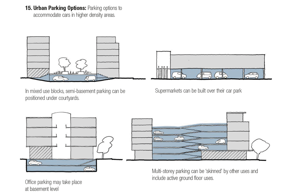
Illustrative drawing. A series of simplified sections showing how parking options can be accommodated in higher density areas. The following captions explain what is being illustrated in each case:
[Alt text: This is the first in a series of simplified sections showing how parking options can be accommodated in higher density areas. The following captions explain what is being illustrated in each case:
- In mixed use blocks, semi-basement parking can be positioned under courtyards.
- Office parking may take place at basement level.
- Supermarkets can be built over their car park.
- Multi-storey parking can be ‘skinned’ by other uses and include active ground floor uses. ]
M.3.ii Cycle parking
51. A design code may also define the appropriate locations and forms for cycle parking, in close proximity to homes and buildings, both for building occupants and for visitors.
52. Cycle parking for occupants must be secure if people are to use it. It also needs to be under cover to avoid problems with bad weather.

Illustrative photograph. A series of 4 photographs showing different cycle parking solutions. The following captions describe what is being shown in each instance.
[Alt text: Illustrative photograph.
This is the first in a series of 4 photographs showing different cycle parking solutions. The following captions describe what is being shown in each instance.
-
Public cycle parking: Visitor parking may be provided via cycle racks in the public realm that are prominently located and well supervised, provided that they do not obstruct pavements or desire lines.
-
Apartments: In apartment blocks cycle parking can be provided in apartments, provided the space is in addition to the Nationally Described Space Standards. It requires level access and an adequately sized lift. Communal bike stores may be provided externally, in basement car parks or in freestanding structures. These should be as near as possible to the entrance for convenience, and both the store and the individual bike stands should be lockable.
-
Housing: In lower density suburban housing bike parking can usually be provided within a garage or a separate structure within the garden. For terraced housing, provision for cycles needs to be made within the property, in the front garden or to the rear with access from a parking court. It is also possible to provide communal bike pods accommodating up to 10 cycles using a single parking bay.
-
Workspaces: In workspaces cycle parking may be provided via dedicated facilities within the building, possibly as part of a basement car park. This may be linked to showers and lockers or even a bike repair hub. ]
M.3.iii Services and utilities
53. New development needs to take into account a range of practical requirements for streets and public spaces such as servicing requirements, access to utilities and reinstatement of road surfaces. If these are not considered they can undermine the quality of space.
54. Design codes may include coding for servicing and utilities arrangements.
Emergency services
55. All developments need to be accessible to emergency vehicles. Sites with limited vehicle access points need to ensure that ambulances and fire tenders can gain access if one of the roads is blocked. This can be a particular problem with unregulated on-street parking.
Refuse collection
56. The road network needs to take account of access for refuse collection and emergency vehicles. The size of refuse collection vehicles varies between local authorities and depending on the waste collection system care needs to be taken to ensure that their turning requirements do not compromise the layout. Local authorities should also be mindful of the existing context to ensure local character and quality of place is not compromised by overestimating this requirement.
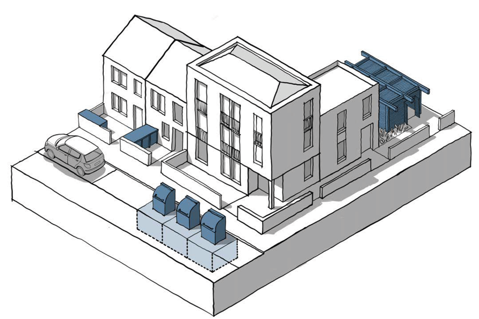
This is a 3D line drawing of a collection of residential houses. It shows the three different refuse collection options set out in the following captions.
In-curtilage Provision: This can be provided to the side or rear of the property in detached housing. For terraced housing, collection needs to either be from the rear or a bin store needs to be provided at the front.
Communal Provision: An alternative for terraced housing as well as for apartments is communal provision. Reference should be given to guidance on carry distances and distances to collection points.
Bring Points: An alternative is to use underground waste storage bins, although this requires a specialist collection vehicle.
Check list: Movement
Local design codes should consider:
M.1 Connected places
- The way in which new development contributes to the creation of an overlooked and well lit permeable street network.
- The provision of public transport and the distance of all dwellings from a stop.
- A framework plan indicating the street hierarchy for the district.
- Safety and security considerations in respect to the layout of streets and footways for all.
M.2 Active travel
- Encouraging walking and cycling and the design of cycle routes.
- Balancing the needs of cyclists, pedestrians with those of vehicles.
- A toolkit of street junctions, layouts in accordance with Manual for Streets.
- Guidance on multi-functional streets including the situations in which they can be used and their design principles.
M.3 Parking and servicing
- How to accommodate the local plan’s parking requirements including:
- Acceptable locations and design of unallocated parking.
- Accommodation of bays for disabled spaces, electric charging and car share.
- Position of on-plot parking. Guidance on the design of parking for other uses.
- Acceptable locations and design of unallocated parking.
- The design and location of cycle parking.
- The design of bins and refuse collection services.
Nature
Introduction
57. Development should enhance the natural as well as the built environment. Nature is essential for health and wellbeing, for biodiversity, shading and cooling, noise mitigation, air quality and mitigating flood risk as well as contributing to tackling the climate emergency. Nature is also central to the creation of beautiful places.
58. Design codes need to ensure that nature and the historic landscape is woven into the design of places. This may include the amount and type of open space, the response to flood risk and the protection, enhancement and promotion of biodiversity.
59. The design coding guidance will be updated to reflect policy changes that are anticipated to drive improvements to our natural environment. Government is committed in the 25 Year Environment Plan to embed a ‘net environmental gain’ principle for development to deliver environmental improvements locally and nationally and to green our towns and cities by creating and improving green infrastructure. Local Nature Recovery Strategies will have a role in identifying land that should be safeguarded for nature and a National Framework of Green Infrastructure Standards for blue and green infrastructure in development.
N.1 Green infrastructure
60. Green infrastructure is a network of multi-functional urban and rural green and blue space which is capable of delivering a wide range of environmental and quality of life benefits. It covers everything from country parks to green roofs and street trees. In terms of new development, the design code may specify levels of green infrastructure provision and guidance on design. The National Framework of Green Infrastructure Standards will provide further detail on principles to guide design.
N.1.i Network of spaces
61. There is a hierarchy of green spaces which play a distinctive role in terms of nature, leisure and quality of life. Urban greening factor tools can determine amounts of green space. Consideration needs to be given to the way that these spaces are linked to provide a network of multi-functional green space and natural features.

[Alt text: A set of 5 photographs showing different levels in the hierarchy of green spaces. The first picture shows Stanage Edge in the Peak District - a rocky outcrop and a popular hiking destination. The second shows a large green space in north Manchester that fronts onto the canal. The third shows Heaton Park in Manchester, a large formal park with slopes overlooking the city. The fourth shows a smaller green space within the Manchester University campus where students often eat lunch and congregate. The final image shows residents on a bench enjoying a park in Chelmsford. ]
The images relate to the following captions:
Rural areas: Around 90% of England lies outside urban areas including pasture and arable land, forests, moors, wetland, natural spaces and National Parks and Areas of Outstanding Natural Beauty.
Natural spaces: Within built-up areas these include land that has never been developed as well as formerly developed sites that have been reclaimed by nature. They include canals, rivers, former railway lines, roadside verges and other transitionary land that form important green corridors.
Parks and formal green spaces: Most settlements have a legacy of parks and other public green spaces like sports pitches, recreation grounds, and cemeteries.
Semi-public spaces: Many institutions like schools and churches are custodians of green spaces.
Squares, village greens and pocket parks: At the neighbourhood level there are smaller areas of green space that are used for local recreation and play.

Figure 17. Hierarchy of Green Spaces.
[Alt text: A series of 6 photographs showing further examples of green spaces that sit within the hierarchy of green space.
The first shows a row of lush mature trees growing from a wide grassy strip between two sides of the street on Highgate Road in London.
The second shows a beautiful communal garden in the Accordia development in Cambridge with raised planters that double as benches, a small stand of trees and lots of well established planting.
The third image shows a shared allotment in Levenshulme, where residents have planted vegetables in raised beds surrounded by wildflowers.
The fourth shows the private and communal gardens of the Malings development in Newcastle. Over the wooden fences we can see an array of plants.
The fifth shows the generous balconies of Timekeepers Square in Salford, where residents are evidently using the space - we can see planters, outdoor furniture and hanging baskets.
The final image shows the Deansgate tram stop in Manchester where a green wall has been installed. The plants have been arranged to create diagonal stripes of different green tones and are striking against the historic brickwork of the bridge and the cool glass surrounding the lift access.]
The images relate to the following captions:
Streets: Can include street trees, verges and planting areas that bring the benefits of green infrastructure to the heart of the built environment.
Communal gardens: Residential areas can include communal gardens within the block or at roof level.
Allotments and food growing: This can include community gardens, orchards, and urban farms.
Private gardens: Within built-up areas a large part of the land is private gardens that contribute significantly to biodiversity.
Balconies: External spaces in apartments can be important for wellbeing and nature.
Green walls and roofs: There are opportunities for greenery and biodiversity through green walls and roofs.
N.1.ii Open space provision
62. Local open space and wider green infrastructure provision is used for sport and play, multi-use and informal recreation spaces as well as being important for nature. Government is updating open space and recreation guidance on Accessibility to Natural Greenspace (ANGSt) to ensure there is sufficient high-quality open space in the right locations, that is attractive to users and is well managed and maintained.
63. The design code can consider the provision of new and enhanced green space as part of new development building in existing open space strategies and standards in the local plan. Approaches to setting open space standards include:
Population-based standards
64. The most common of these is the FIT standard (what is still often known as the National Playing Field Association 6 Acre Standard). This is widely used to define sports provision and informal outdoor space requirements. The provision of new and enhanced outdoor sports facilities should be considered in order to meet locally defined needs.
65. It can be difficult to achieve at higher densities, and the design code may provide guidance on how this is to be interpreted. This could include an assessment of existing open space provision set against ward population data to assess the extent to which the standard is being met. New schemes may then be asked to contribute towards meeting any shortfall.
Accessible greenspace standards
66. An alternative is to look at the distance to different types of open space. Thus higher residential densities would not increase the amount of open space required, subject to its quality. The code would map each type of open space and show walking distance around them as circles and isochrones. This will highlight poorly served areas where new development may address the shortfall.
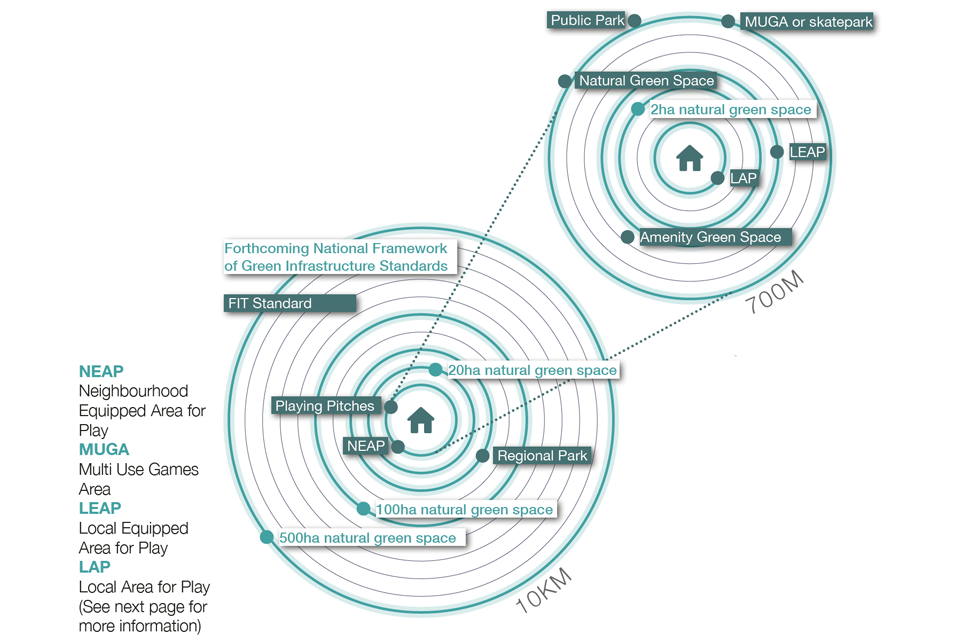
Figure 18. Open Space Accessibility Standards:
The forthcoming National Framework of Green Infrastructure Standards by Natural England will provide new standards for green infrastructure (ANGSt standards) suggesting that all people should have access to a natural green space close to home.
Benchmarks in the green infrastructure standards will include guidance on size/ distance criteria and the implications of residential densities on provision of green space, particularly in dense urban environments; and will be accompanied by a national map which will show where these criteria are not currently met, to help guide provision of green spaces to the places that need it most.
Communal areas, such as playgrounds, play areas, seating facilities need to be overlooked by nearby buildings, have safe and accessible routes for users and clear definition of boundaries to ensure they are secure.
Fields in Trust suggests that all homes should be within recommended distances to parks, playing pitches, NEAPs (Neighbourhood Equipped Area for Play), MUGAs (Multi Use Games Area), LEAPs (Local Equipped Area for Play) and LAPs (Local Area for Play).
[Alt text: Illustrative diagram.
This is a complex diagram which does not lend itself well to written translation, but is intended to illustrate the various open space accessibility standards discussed in the preceding text.
The image is set up as two sets of concentric circles around a simplified infographic of a house. One set has a range of 100-700 meters and shows all the types of green spaces that should be accessible to people within that range: A local area for play (LAP), a local equipped area for play (LEAP), an amenity green space, a natural green space, a multi use games area (MUGA) or skatepark and a public park.
The other set of concentric circles has a range of 1-10 kilometers and shows all the types of green space that should be accessible within that distance range: a neighbourhood equipped area for play (NEAP), playing pitches, a regional park, a natural green space of over 20 hectares, plus natural green spaces of over 100 hectares and 500 hectares at further distances. ]
N.1.iii Open space design
67. The way in which spaces are designed is crucial to their success. The design considerations vary with the type of space, a formal park being very different to a large natural open space. The situation where the design code is likely to be most relevant is in the design of new smaller open space within new development. In this case, the following principles are important:

Figure 19. Types of Play Space:
Policy for play areas is based on three levels of provision for play friendly spaces that are accessible and inclusive for all. This could include other bespoke approaches such as adventure play, play for older children including teen play, the concept of doorstep play in higher density housing and integrated approaches to play with nature and the built environment. These relate to the size and level of equipment provided but also the age of the children for which it is designed. The three levels are:
-
Local Areas of Play (LAP), with a few fixed items of play near to the home.
-
Local Equipped Areas of Play (LEAP) With at least five pieces of equipment for slightly older children.
-
Neighbourhood Equipped Area of Play (NEAP) With at least eight pieces of equipment along with a Multi-use games area (MUGA) and/or a skate park/bike track.
[Alt text: Three 3D line drawings that illustrate different types of play space, explaining some of the terms used on the previous page. In each case the drawings show plenty of well integrated trees and biodiversity along with the play equipment when illustrating the preceding captions.]

This is a 3D line drawing that shows an open space surrounded by streets and houses on all sides. It illustrates the following principles of good open space design:
1. Boundary: Consideration needs to be given to whether the space is fenced and gated without interrupting wildlife networks.
2. Entrances: Access points and paths need to be conveniently located on desire lines for walking and cycling.
3. Surveillance: Open spaces need to be overseen from surrounding buildings, streets and public spaces.
4. Activity: Sufficient space needs to be provided for sports pitches and play areas to avoid conflict with other uses.
5. Maintenance: The design of the space needs to take account of maintenance and adoption requirements.
6. Ecology: Green spaces need to include areas that are nature-rich.
7. Access: Public open space needs to be accessible and welcoming to everyone.
8. Lighting: Needs to be considered for well-used footpaths and games areas but should avoid light spillage that causes nuisance and harms wildlife.
9. Allotments and community growing: need to consider community growing projects for food production, learning and community engagement on large developments.
N.2 Water and drainage
68. Managing water is an important element of a site’s response to nature. It can reduce flood risk and improve water quality while providing habitats and recreational activities and dealing with flooding when it happens.
N.2.i Working with water
69. Many sites will include water in some form, and the National Design Guide can provide guidance on maximising the benefits.
70. Development adjacent to existing water features, including rivers, lakes, canals, docks and wetlands has an important role to play in enhancing the value of blue infrastructure as public realm, habitat, ecological corridor and natural capital asset.
71. Buildings may face the water and leave a sufficient buffer zone to allow for watercourses and banks to be maintained and for current and potential future flood defences. Opportunities to create walking and cycling routes along watercourses where appropriate need to be encouraged.
72. Opening up culverts, reinstating meanders and restoring and naturalising river beds and banks can benefit wildlife and improve public access and flood attenuation.

This is a 3D line drawing of a set of buildings fronting onto a body of water. It illustrates a number of principles described in the preceding text.
N.2.ii Sustainable drainage
73. Sustainable drainage systems or SuDSmimic natural drainage in delivering effective surface water management, controlling surface water close to where it falls. They are designed to reduce the rate of rainwater run-off from new development, mitigating the risk of flooding elsewhere whilst delivering benefits for biodiversity, water quality and amenity. Ideally water needs to be captured for use on site for irrigation and non-potable uses. Where this is not possible schemes need to follow the hierarchy set out in guidance, by which water is:
- Allowed to infiltrate into the ground in a way that mimics natural drainage.
- Attenuated for gradual release to a water body.
- Released into a water sewer, highway drain, or another drainage system.
- Released into a combined sewer.
74. The approach to each site will depend on its density, the position of watercourses, the ground conditions including water permeability, contamination and the sensitivity of groundwater receptors.
75. SuDS need to be considered early in the design process to ensure ease of access for maintenance and efficient use of land by integrating them with other aspects of design such as public open space, biodiversity provision, and highways. Multi-functional SuDS need to be prioritised allowing for attenuation features which can also be used for biodiversity and recreation.

This is a 3D line drawing of a residential block surrounded by different areas of open space and green infrastructure features. It illustrates a range of sustainable drainage solutions, as set out in the following caption text:
1. Green roofs and walls: Provide capacity to hold and attenuate water run-off as well as ecological and leisure benefits.
2. Permeable surfacing: Surfaces that allow water to percolate into the ground including, natural surfaces, gravel and low traffic volume engineered road surfaces and hard- standings in front gardens.
3. Swales: Shallow channels that provide attenuation while also channelling water to other features such as ponds.
4. Rain capture: Water butts and other rainwater harvesting systems collect rainwater for use in gardens or for non-potable uses reducing water consumption.
5. Soakaways and filter drains: Shallow ditches and trenches filled with gravel or stones that collect uncontaminated water and allow it to percolate into the ground.
6. Retention tanks: In high density schemes water can be attenuated in underground structures.
7. Street tree planting: SuDS designed into highway provision can provide dual use benefits when integrated with street tree provision.
8. Rain gardens: Containers and ditches with native drought tolerant plants release water gradually and filter-out pollutants.
9. Basins and ponds: Attenuation ponds that are normally dry but fill during a rain event and then either store or gradually discharge water to the system.
10. Reedbeds and wetlands: Topography can be used to create wetlands that provide attenuation capacity as well as filtering out pollutants and providing habitat for wildlife.
N.2.iii Flood risk
76. Flood risk needs to be considered early in the design process based on an understanding of all sources of current and future flood risk and alongside other design factors.
77. The sequential test should be used to steer development away from flood risk areas. Where flood risk areas are unavoidable, development should be designed to ensure it will be safe from flooding throughout its lifetime, without increasing flood risk elsewhere.
78. Vulnerable uses need to be laid out and designed using flood avoidance measures such as:
- Locating buildings on the lowest risk parts of the site
- Raising finished floor levels above predicted flood levels
- Using upper storeys for habitable areas of housing, with ground floors used for less vulnerable or non-habitable uses (e.g. garages).
- Lower vulnerability uses should also be located and designed to avoid flooding. However, if flood risk is unavoidable, low vulnerability uses should incorporate resilience measures in accordance with the Property Flood Resilience Code of Practice to resist flood water and ensure they can recover quickly in the event of flooding.
80. Where the safety of development relies on emergency planning measures it should include safe, signposted access and escape routes in accordance with the ADEPT/EA guidance on flood risk emergency plans for new development. Wherever possible these routes need to remain dry, but as a minimum, they should be designed to ensure people will not be exposed to hazardous flooding. It may also be necessary to include a place of refuge above predicted flood levels.
81. All developments should seek to reduce flood risk. This could be through making more space for water, increasing infiltration, providing new or improved flood defences or through natural flood management techniques.

Figure 23. Flood Resilience Principles.
- Steer development away from flood risk areas
- Use flood avoidance measures Use flood resistance and recovery techniques
- Provide safe means of access, escape and refuge
- Seek to reduce flood risk
[Alt text: Illustrative CGI. An image produced by JTP Architects and the Environmental Design Studio showing housing that would be resilient to flooding. The scheme includes a “light touch” ground floor which allows water to pass through without displacing it to another location, habitable rooms elevated to first-floor and above and a resilient ground floor ‘garden room’ zone - a multiuse space that can be quickly adapted and cleaned post flood.]
N.3 Biodiversity
82. All new development needs to use, retain and improve existing habitats or create new habitats to achieve measurable gains for biodiversity. This includes landscaping and tree planting.
N.3.i Biodiversity net gain
83. Local Nature Recovery Strategies (LNRS) to map and identify opportunities to create and enhance local biodiversity will be included in the Environment Bill. These strategies are intended to assist developers in achieving biodiversity net gain and need to be referenced in the design code.

Figure 24. Biodiversity Net Gain: Development will be expected to produce a +10% increase in biodiversity.
[Alt text: Illustrative infographic. Two very simplified images. The first shows an area with a tree, plants, bird and bee. The second shows the same area with a house in the centre. There is also an additional tree, more plants and another bird. It is intended to illustrate the biodiversity net gain principle in the preceding text.]

The 1st photo shows a bee brick, a brick incorporating holes of different sizes to provide a nesting site for solitary bees. The 2nd image shows a "hedgehog highway" - a hedgehog sized hole in a wall to allow hedgehogs to move across their territories.
[Alt text: Illustrative photograph. This 1st photo shows a bee brick, a brick incorporating holes of different sizes to provide a nesting site for solitary bees. The 2nd image shows a “hedgehog highway” - a hedgehog sized hole in a wall to allow hedgehogs to move across their territories.]
84. Design codes will be expected to reflect the minimum 10% net increase in biodiversity compared to the situation prior to development. The broader environmental net gain approach includes wider beneficial environmental outcomes that can be delivered such as flood protection, recreation and improved water and air quality.
85. Natural assets such as ancient woodlands, designated sites, mature trees, and protected species should be protected and enhanced (where possible) in the design of the schemes. Priority habitats and priority species should also be considered within the design process.
86. A baseline assessment needs to be undertaken prior to development using the Natural England Biodiversity Metric 3.0 to measure the existing value of the site (this will become mandatory under the Environment Bill). The proposed post-development design will similarly be assessed to show a minimum 10% improvement (including any offsite provision where necessary)
N.3.ii Planning for biodiversity
87. The design code should be based on a hierarchy that first seeks to avoid damaging habitats, then to mitigate that damage and then, if this is not possible, to consider replacement habitats.
88. Measures using green/infiltration SuDS that improve water quality and create habitats should be included where possible.

Figure 26. Biodiversity Design Principles:
Alt text: Illustrative drawing. This is a 3D line drawing showing a residential neighbourhood from above. It is comprised of a number of blocks of low to medium density development separated by areas of green open space. It illustrates the biodiversity design principles set out in the following captions:
-
Planting: To provide nectar, nuts, seeds, native vegetation and berries along with trees and shrubs, logs and stones. Native plant and tree species are generally, but not always, better for wildlife.
-
Creating habitats: Strategies need to be considered for creating natural habitats, for example, through use of trees, wildflowers and ponds as well as bat and bird boxes, bee bricks and bird bricks and hedgehog highways.
-
Enhancing habitats: Management of native planting, foraging grounds for bats, feeding grounds and wetlands for birds and forest floor habitats.
-
Ecological niches: Can create a range of ecological conditions from woodland transition zones to wetland areas and open grassland.
-
Existing features: Natural assets such as trees, woodlands, hedges, wetland areas and other natural features need to be retained and enhanced where possible.
-
Rivers: Restoration techniques create habitat and reduce flood risk.
-
Mosaics: A range of elements and structures as small patches of bare ground, tall flower-rich vegetation, or scattered trees and scrub to support a range of species and their life-cycles.
-
Trees and hedgerows: These should be incorporated into public realm and other open spaces as well as private development where appropriate.
-
SuDS and rain gardens: These can be designed to provide benefits to nature by including planting and habitat niches.
-
Ecological network: Masterplans should create an interconnected ecological network that encompasses everything from doorstep spaces and private gardens to the surrounding countryside.
-
Green roofs & walls: Green facades provide nesting opportunities and food for bees. Habitats can also be created on roofs and are especially beneficial for birds and insects.
N.3.iii Street trees
89. Street trees and other landscape features in streetscapes provide habitat, shading, cooling, air quality improvements and carbon sequestration, as well as being a vital component of attractive places. It is the government’s intention that all new streets include trees and the Urban Tree Challenge Fund is planting 130,000 urban trees across England. Guidance on installation, management and maintenance is available in the Urban Tree Manual, and considerations include:
Species: Codes may include a list of species as a palette for use by developers including non-native species which can provide valuable habitat. These help to establish different area types and need to take account of local climate, shape, size, fruit and pollen. A variety of trees provides biodiversity and biosecurity resilience.
Position: Careful positioning to allow space for the mature tree without causing obstruction or interfering with property, infrastructure, street lighting or junction sightlines. This can be on median strips, verges or interspersed with parking bays but only on pavements where the mature tree will not block access.
Function: Ensure street trees and green infrastructure provide for a range of functions and benefits and sufficient to help improve air quality and reduce noise from the street network.
Services: Coordinating tree planting with utilities providers and service ducts early in the lifetime of a scheme can ensure that trees do not interfere with underground services.
Specification: Care is needed in heavily trafficked areas to avoid the compaction of the soil around the tree. Guidance on tree planting, pits, guards and other technical specifications are widely available and have a significant impact on the tree’s survival prospects.

This is a 3D line drawing of a residential street. A large mature street tree is integrated into an area of on street parking.
Check list: Nature
Local design codes should consider:
N.1 Green infrastructure
- The creation of a network of green spaces and other green infrastructure such as green corridors and street trees, which provide multiple benefits for biodiversity, nature, recreation, climate change resilience and support health and wellbeing.
- The provision of open space based on the government’s Open Space and Recreation Guidance and an open space framework plan.
- The provision of children’s play in accordance with national guidance including its location, size and design.
- Guidance on the design of green spaces.
- The use of greening factors to deliver quantifiable levels of greening.
N.2 Water and drainage
- Guidance on the design of development next to water.
- Performance standard and the design of sustainable drainage systems.
- Guidance on development within flood risk areas based on Environment Agency guidance including flood mitigation and resilience.
N.3 Biodiversity
- Implementation of the government’s Biodiversity Net Gain Policy and the Local Nature Recovery Strategies.
- The retention of natural features such as trees, woodlands and hedgerows and other ecological features.
- Guidance on design for biodiversity.
- The provision of street trees relating to types of streets plus the design, placement and species to be used.
Built form
Introduction
90. The National Design Guide defines the ‘built form’ of an area as the ‘three- dimensional pattern or arrangement of development blocks, streets, buildings and open spaces’ that make up any built-up area or development. It says that a well-designed place has a coherent form of development. For built form this means:
- A compact form of development
- Appropriate building types and forms
B.1 Compact form of development
91. A compact form of development is more likely to accommodate enough people to support shops, local facilities and viable public transport, maximise social interaction in a local area, and make it feel a safe, lively and attractive place. In this way, it may help to promote active travel to local facilities and services, so reducing dependence on the private car.
92. What is meant by compact will vary according to area type and context. A design code may define an appropriate measure of compactness for new development in relation to an area type.
B.1.i Density
93. Density is one indicator for how compact a development or place will be and how intensively it will be developed. However, in itself it is not a measure of how appropriate a particular development may be within an area type. For this it needs to be combined with coding for other design parameters, including those set out below.
Residential density
94. A design code may set out local densities or ranges of density, particularly on large sites with an average overall density, where local variations in density may be desirable in order to create a variety of identity without harming local character as set out in Historic England guidance.

Figure 28. Measuring density: A local variation in density creates a variety of built form character in Cambourne. Area A has 94 homes on 2.6 hectares – a net density or 36 dwellings per hectare (dph). Area B has 32 homes on 1.8 hectares, so is around 20 dph. Note the area measure runs to the back of each plot and the centre line of the roads.
[Alt text: Illustrative drawing. Shows a top down plan of an area of residential development and relates to the preceding text on measuring density. As highlighted in the text, one area of the plan is of a higher density (with more rows of terraces) than the other area (which has more detached and semi detached houses).]

Figure 29. Plot Ratio and Plot Coverage: The former is the ratio between site area and the total building floor area while the latter is the proportion of the site area occupied by buildings. These two measures can be combined to control development and should be used alongside good urban design principles. For instance, a Plot Ratio of 2 means that the floor area can be twice the site area while a Plot Coverage of 0.5 means that only half of the site area can be developed.
[Alt text: Illustrative drawing. The image relates to the preceding text on plot ratio and plot coverage. It is set out as a table with plot ratio along the right hand side and plot coverage along the top. The table is populated by a series of 3D line drawings, showing simplified height and massing options for buildings depending on their plot coverage and plot ratio. The drawing seeks to show the relationship between them. For example a plot coverage of 2, can be configured as a tower taking up a relatively small portion of a plot, with a plot ratio of 0.25. Or, it can be configured as a lower building, of only a few storeys, taking up the entire plot (a plot ratio of 1)]
95. For housing development, density can be measured using plot ratio, dwellings per hectare, or bed spaces per hectare. Density in dwellings per hectare may be measured using gross or net density. Design codes may consider the appropriate measure of density for a given situation.
Density for other uses
96. For non-residential or mixed-use development density can be measured by plot ratio or plot coverage. The former indicates how much of the site the building is able to occupy while the latter is the ratio of site area to the area of development.
97. A design code may set out local densities or ranges of density for non-residential or mixed-use development.
B.1.ii Whether buildings join
98. When buildings join to neighbouring buildings the form of development is more compact than when they do not. Freestanding buildings generally occupy wider plots, which affects both density and compactness.
99. Design codes may include coding that enables or prevents buildings from joining to each other, depending upon the area type. Alternatively, coding for building lines (see B2.2) may be used to achieve a similar outcome.
B.1.iii Building types and forms
100. The character of an area is also influenced by the variety of building forms. This relates to the size and uniformity of the buildings. Large buildings may occupy an entire block, whereas the same area could be developed with a variety of smaller buildings. In many places it is the rhythm and variety of these smaller buildings that is intrinsic to the character of the area. While large buildings will be appropriate in places, an area made up entirely of large buildings can be dull.
101. This is referred to as urban grain and it derives from the size and configuration of plots. Masterplans need to indicate this plot structure, which together with the way that buildings join will determine the character of the development. Plot based masterplans can also be used to accommodate custom-build and self-build development (see section U2:2) with the Code parameters summarised in a plot passport, where relevant.

Figure 30. Buildings joining.
[Alt text: Illustrative drawing. This is a series of three 3D line drawings showing different configurations of a row of simplified houses. The first shows a row of terraces, the second shows two sets of semi-detached houses, the third shows a row of detached houses. The following captions explain the different party wall treatments in each instance:
-
Joining on both sides: Party walls on both sides leads to terraced housing.
-
Buildings joining on one side: Leads to semi-detached housing.
- Buildings not joining: Leads to detached housing. A code may also specify a set-off distance, say 1m, from plot boundaries. ]
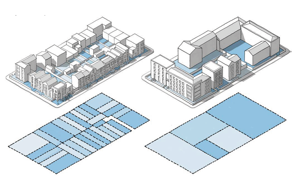
Figure 31. Urban Grain: Blocks can be developed with buildings of different sizes, based on the arrangements of plots. A larger number of smaller buildings can create greater variety and visual interest.
[Alt text: Illustrative drawing.
This is a set of 3D line drawings of two different block structures, with their plot arrangement set out underneath in plan form. The first 3D block drawing shows a rectangular block, with numerous buildings with narrow facades and small or minimal separation, arranged around the periphery. The plan beneath shows the many narrow plots that comprise the rectangular block.
The second 3D block drawing shows the same rectangular block, this time populated by larger buildings with broader facades and more space between one building and another. The plan beneath shows a smaller number of larger plots that comprise the rectangular block. ]
B.2 Built form
102. A design code may define a three-dimensional envelope for new buildings. The size and shape of this will vary depending on the nature of the area type and the blocks within it. This envelope consists of three separate measures: the development blocks established by the street network, the alignment of the front face of the building, and the height of the building.
B.2.i Blocks
103. A connected network of streets defines a series of blocks for development.
104. Built development blocks define the edge, and the three- dimensional enclosure of street spaces and their uses help to animate them.
105. Where development takes place around the edges of blocks, they are known as perimeter blocks. Provided that buildings face outwards onto the surrounding streets, perimeter blocks also create a clear distinction between the public fronts of buildings and the private backs. This has important benefits in terms of safety and security.
106. Area types will have an established network of streets and blocks. Coding can help ensure that the built form of new development in these areas relates well to the existing pattern of development.
107. On large sites a design code together with a masterplan may establish a new street network and structure of development blocks.

Figure 32. Blocks.
[Alt text: Illustrative drawing. This is a 3D line drawing of a mid density urban block. The image relates to the preceding text on blocks, and illustrates the difference between public space (on the outside of the block, e.g. the pavement, street etc) and private space (within the block, e.g. private back gardens, parking etc).]

Figure 33. Examples from different places show how many of them are based on different types of perimeter block.
[Alt text: Illustrative drawing.
Top down plan of Leeds City Centre showing rectangular perimeter blocks.
Top down plan of City of York showing smaller, generally square blocks, packed tightly together.
Top down plan of Letchworth Garden City showing more organic, low density perimeter blocks populated with mainly detached and semi detached buildings.
Top down plan of City of London showing rectangular perimeter blocks.
Top down plan of Ludlow showing highly regular rectangular perimeter blocks, packed closely together.
Top down plan of Bishops Castle, Shropshire, showing more organic perimeter blocks which vary in density around their perimeter. One edge comprises continuous buildings, while the other has more detached buildings with larger spaces between. ]

Figure 34. Types of Block: There are a wide variety of perimeter block forms that can accommodate housing and other uses:
[Alt text: Illustrative photos & drawings
The first image shows a view along the facade of the Roof Gardens development in Salford by Ollier Smurthwaite Architects, as example of a perimeter block. A top down plan drawing of a 40-50 meter wide perimeter block.
A photograph of The Pheasantry, West Sussex by AHR Architecture and Building Consultancy and Hastoe Housing Association. An example of an informal block. A top down plan drawing of an informal block, with semi detached houses arranged around the perimeter.
A photograph of Marmalade Lane, Cambridge, by Mole Architects - an example of a terrace. A top down plan drawing of a 25-30 meter wide terraced block.
An image of Accordia Sky Villas in Cambridge, by Alison Brooks Architects - an example of a mews block. A top down plan drawing of a 60-70 meter wide mews block. Residential units are set out around the periphery of the block, but a small street also runs through the middle of the block, allowing access to rear garages/annexes separated from the main property by gardens.
The image shows Donnybrook Quarter in Tower Hamlets, by Peter Barber Architects, an example of a courtyard block. A top down plan drawing of a courtyard block.]
1. Perimeter block: A strip of development around a private courtyard/gardens. The private interior is not accessible to people from outside the scheme. It includes private and communal gardens and car parking.
2. Informal block: Blocks like this can be found in many modern housing schemes. The housing faces outwards onto the surrounding streets with front and back gardens. The extra width allows a parking court to be included alongside houses and garage blocks within the courtyard to provide natural surveillance.
3. Terrace: The most common form is the typical English terrace which may include a rear alleyway. Codes for area types that include existing terraced housing need to consider reductions in back- to-back distances, compared to common practice so that new development relates to the context.
4. Mews block: Mews streets run through blocks, originally accommodating stable blocks to the rear of large houses. Now they have generally been converted to separate homes and workspaces. Modern versions of mews blocks include smaller single aspect homes above garages within the block.
5. Courtyard block: Sometimes buildings join to each other (party wall) not just on either side but also to the rear. This is a characteristic form of many historic cities (like York on the opposite page). There are also modern versions of this type of block with deep housing types with an internal courtyard.
B.2.ii Building line
108. Attractive streets and other public spaces are generally defined by the frontages of buildings around their edges.
109. A building line represents the alignment of the front face of the buildings in relation to a street or other public space. The nature of this line and its position in relation to the street contribute to the character and identity of a place. It may be straight or irregular, continuous or broken. A consistent approach to building line in an area type or street type helps to give it a coherent identity.

Figure 35. Repairing Urban Blocks: Infill sites can be an opportunity to repair the block structure and street grid of an area. This example shows an infill site that has been brought forward for housing development.
[Alt text: Illustrative drawing. This is one of two top down plans of a residential neighbourhood, comprised of a number of blocks. The smaller plan shows a large empty site surrounded by an existing block structure. This plan shows the same area, with new roads and blocks within the empty site, connecting into and reflecting the existing structure.]

Figure 36. Different area types are likely to have different building lines: A high street is likely to have a continuous building line set close to the street. In a suburban area the building line may be set further back from the street, with gaps in it.
[Alt text: Illustrative drawing. This is the first of two 3D line drawings of development fronting a street. They relate to the previous text and illustrate how different area types are likely to have different building lines. This image shows a suburban residential street where the building line is set back by front gardens and there are gaps between the buildings. The second image shows a high street, where the set back from the street is minimal, and the building line is continuous.]

Figure 37. Building Line Character: The shape of the building line will contribute to the character of the area. Orthogonal arrangements are more likely to be found in urban areas while curved streets are more suburban with detached building forms. The third option with irregular geometry that can be seen in some historic urban areas, from cities to villages.
[Alt text: Three highly simplified 3D line drawings showing different shapes of building line. The first is regular and orthogonal, with rectangular blocks set at right angles. The second is curved and sinuous, with winding streets. The third is irregular, but angular, with curves being formed from sharp angles rather than sweeping lines.]
Coding for the building line
110. Design codes may identify building lines and their characteristics for each area type to guide new development, including circumstances that allow for exceptions, e.g. where a mature tree interrupts the existing building line or creates a public space or forecourt.
111. They may also identify the proposed building lines for a large site based on the agreed masterplan, taking into account the hierarchy of streets, as well as the proposed area types.
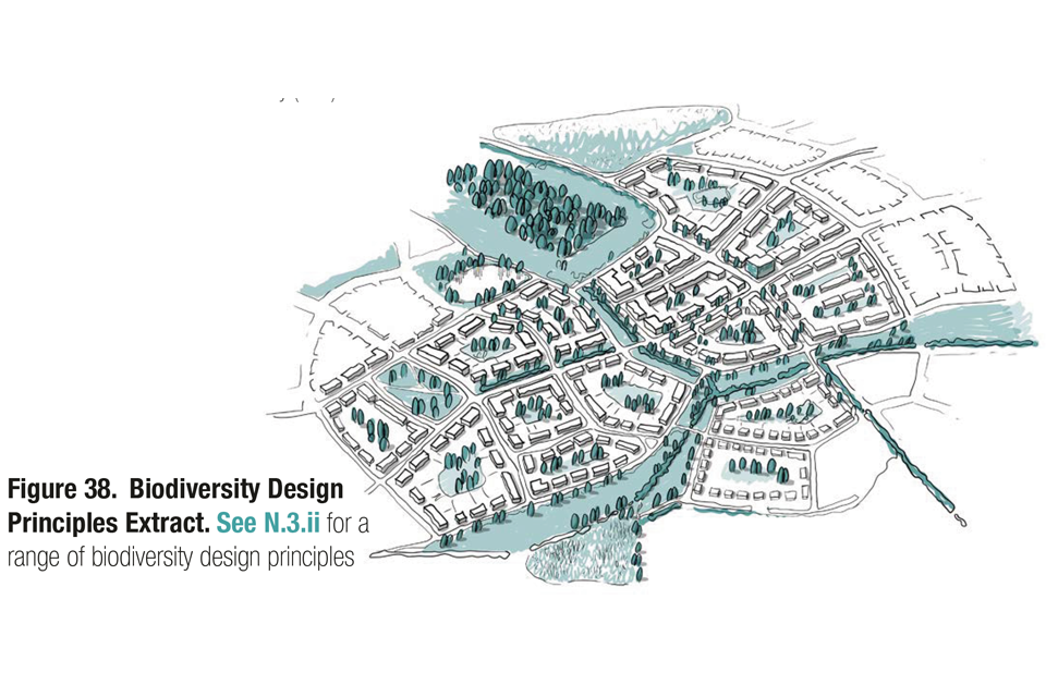
3D aerial line drawing of a no. of neighbourhoods, linked by, and surrounded by, green spaces. This is an extract from the Nature section of the guidance notes, which provides more detail on biodiversity design principles and annotations for the drawing.
[Alt text: Illustrative drawing. This is a top down plan showing the existing building line of an urban area, incorporating a large section of a town, comprised of multiple blocks. The plan relates to the preceding text on building lines. It illustrates with a continuous line where the building line is already in existence, and a dashed line where the building line needs to be reinstated. New development areas where the building line has been set are shaded in blue.]
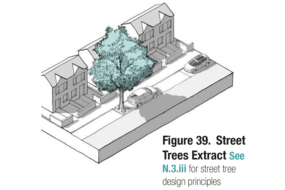
This is a 3D line drawing of a residential street, with a mature tree integrated into the street, located between bay car parking spaces. This is an extract from the Nature section of the guidance notes which provides more detail on biodiversity.
Building line characteristics
112. A design code may set parameters that relate to the building line:
Variance: The code may specify how far buildings are able to depart from the building line. This will depend on the importance of the frontage. In certain areas no variance will be permitted. Elsewhere buildings or parts of buildings might be allowed to set back or project forward of the building line by a prescribed distance.
Compliance: The proportion of the building line occupied by buildings may be specified. In a centre, the building line is likely to be continuous. In a suburb, there are likely to be gaps between buildings.
Activity: The building line is the interface between the interior of each building and the public life of the street. A design code may consider how the building line enables interaction with the street (see Section U1.3).
Access: Design codes may specify how buildings relate to the street in terms of access. It may be appropriate for vehicle access, servicing and secondary pedestrian access to be from the rear while the public or main entrance and ‘address’ is through the building line.
Eyes on the Street: Successful streets are characterised by active edges and natural surveillance, so that the street space is overlooked from homes and businesses.

This is a 3D line drawing of a residential street of three storey town houses. A large church is set back from the building line, with the houses on either side. It relates to the preceding text on exceptions to the building line.

Figure 41. Building Line Compliance: Design codes could specify the percentage of the building line to be filled with buildings.
[Alt text: Illustrative drawing. This is an infographic comprised of several front-on views of streets. It relates to the preceding text on building line compliance, and shows different percentages of the building line that could be filled with buildings, ranging from 100% in a high density urban environment, to 45% in a low density residential setting.]
B.2.iii Height
113. Building heights influence the quality of a place in terms of its identity and the environment for occupiers and users. Consistent building heights, or variation within a relatively narrow range, can help to make an area type feel coherent. Large variations in height can make an area feel dynamic.
114. The identity of an area type may be influenced by building heights, including its overall scale, its skyline, key views and vistas and the relative prominence of landmark buildings. Building height may also have an impact on local environmental conditions in neighbouring properties, amenity spaces and public spaces in terms of daylight, sunlight, overshadowing, wind and micro-climate. The placing of tall buildings needs to maximise user comfort of spaces between buildings by taking into account their impact on orientation and overshadowing of public and private spaces, quality of external spaces at ground level, wind tunnel effect, noise pollution and enable safe dispersion of pollutants.
115. The number of storeys is a common way to estimate the height of residential development in suburban and rural area types. In urban area types and for mixed-use development, a more precise measure is appropriate.
Figure 42. Heights: A design code may regulate one or more of the following: eaves or parapet height, roof height and total height. Many building types have projections that rise above the general height of a roof. A code may either allow for projections above a roof height or define a total height including for projections. In both cases the area of any projections may need to be defined in the code.
[Alt text: Illustrative drawing. Two simplified 3D line drawings of buildings. They relate to the preceding text on heights and show how rules can differ between residential development and offices. In a residential setting for example the first, second and subsequent floors will likely be around 3 meters in height. For offices the first floor might be 6 meters, with subsequent floors of around 4 meters.]

Figure 43. The Street Section: The eaves height will contribute to the apparent height of buildings and therefore the character of the street.
[Alt text: Illustrative drawing. This is an illustrative line drawing of a street section, with buildings on either side of around 6-7 storeys. The drawing illustrates the differences highlighted in the previous image, between the storey heights of offices and residential buildings. The office building is taller, despite not having significantly more storeys.]
Eaves or parapet heights: In simple terms multiplying the storey height by the number of storeys will generate the eaves or parapet height. This is the height of the building’s walls excluding the roof. The eaves or parapet height will usually be the apparent height of the building from the street and so determine the cross-section of the street. A code may set out a maximum and possibly a minimum eaves or parapet height for each area type and type of street.
Measuring height: It is also important to specify how building height is to be measured. Typically this will be the height above pavement level. An alternative approach is to use AOD (Above Ordnance Datum) measurements. These are likely to be more appropriate in area types with slopes, or where ground levels may be reconfigured.
Variances: There may be situations or locations where it is appropriate for a building to be taller than those in its immediate context, to create a local landmark or, in certain area types, a tall building (see overleaf). A design code may define criteria to allow exceptions to height parameters in specified circumstances.
Tall buildings
116. Tall buildings can be considered in design codes. It may be appropriate to include criteria for the locations of tall buildings in some area types.
117. A tall building for the purpose of the code would be any structure that exceeded the general height guidance for a particular area type. Tools that can assist with this include:
- Accessibility measures such as distances and travel times to key facilities, including public transport stops or hubs;
- Characterisation studies and design strategies, dealing with issues such as urban form, historic character, building typologies, prevailing sunlight and daylight levels, green infrastructure, amenity space and quality of external spaces at ground level.
118. The policy on the location of tall buildings is likely to be part of the local plan and would take into account the factors in Figure 44.

Figure 44. Tall Building Principles: Topography, characterisation studies heritage assets, local historic character and conservation areas, transport accessibility, identified long views and skylines to be protected, sensitive local views, vistas and gateways.
[Alt text: Illustrative drawing. This is a simplified 3D line drawing of an urban area, illustrating some of the tall building principles outlined in the preceding text, for example important views and vistas. It also shows in blue shading the potential building envelopes for an area where tall buildings are deemed to be acceptable.]
Check list: Built form
Local design codes should consider:
B.1 Compact development
- The maximum and minimum residential densities relating to each area type.
- Plot ratio or plot coverage for commercial development relating to each area type.
- The way that buildings join in each area type.
B.2 Built form
- The separation of public and private space and the use of blocks, including cul-de-sacs and gated communities.
- The design and types of block.
- The use of infill sites to repair block structures.
- Establishing and repairing building lines.
- The setback, variance, and compliance with the building line for each area type.
- The height of buildings for each area type.
- The location and height of tall buildings.
Identity
Introduction
119. The identity of a place comes not just from the form and appearance of the buildings and spaces but also from the way that it is planned, its natural environment and the use of its buildings. This includes the way that it responds to the character of the local area and the design of its buildings and public spaces.
120. Identity may come out of respecting and enhancing the existing character of the area and also from adapting and shaping to develop new character. The architectural approach needs to be influenced by its surrounding architectural character.
I.1 A sense of place
121. A sense of place is the quality that makes a place special and lodges it in the memory so that people want to stay or return. It results from the combination of many factors. Design codes may include guidance on how to draw inspiration from the existing context, to create or enhance a sense of place through new development, and to follow some simple principles of scale and proportion in the design of new buildings.
I.1.i Local character
122. The Context section sets out how a design code starts from an analysis of its area type, in order to understand the place. This analysis informs the elements of a design code and has particular importance when addressing local identity.
123. The analysis will include local building types, architectural styles, materials, detailing and colour. While there are many beautiful neighbourhoods, towns and historic villages, there are also places whose existing character is not particularly attractive. Existing character is therefore something that must be understood as a starting point for the design of layouts and buildings so that they fit into and also enhance the character of the local area. Historic England guidance sets out approaches to assessing the character of places.
I.1.ii Legibility
124. The legibility of a place relates to how easy it is for people to find their way around. Certain characteristics of urban areas may help make them easier to navigate. This is particularly important to meet the needs of specific people including those with dementia, and other visual and mental disabilities through use of inclusive wayfinding strategies. These include:
-
Paths: A clear and walkable network of streets and other routes that doesn’t involve diversions for pedestrians because of the way that highways are designed. (see Section M2).
-
Street hierarchy: A clear hierarchy of streets whereby movement is related to land uses and street character, for instance so that shops and public uses are on a high street.
-
Neighbourhoods: Places with names and a distinctive identity.
-
Nodes: Meeting places and intersections that are perceived as the centre of a neighbourhood.
-
Intensity: The idea that the density and height of development rises towards nodes including town centres and high streets.
-
Landmarks: Memorable built form including landmarks (see B2.3).
-
Wayfinding: Clear, inclusive and logical signage, maps and local information.
I.1.iii Masterplanning
125. On larger sites the first step in enhancing and creating local identity is to create a distinctive masterplan for the site. Masterplans can take many forms and will need to be influenced by the character of the surrounding area. In some cases, a formal masterplan with a grid of streets will be appropriate, whereas elsewhere a more organic plan will fit better with the surrounding context. However, there are a number of ways in which all masterplans can create a sense of identity and character.

This is a 3D line drawing of a mid to high density area, comprised of a number of blocks. It illustrates the following captions which describe how masterplans can create a strong sense of place.
-
Well-proportioned streets: The width of the street and the height of the buildings relate to its place in the street hierarchy.
-
Marking corners: Using architectural features for emphasis on corners.
-
Unique businesses: Encouraging space for local businesses which are distinctive to the area.
-
Public art: Encouraging the use of public art in the design of buildings and spaces as well as free-standing pieces.
-
Vista ends: Using taller buildings and architectural expression on buildings that close vistas along a street or square.
-
Neighbourhood character: Using colour, materials or specific details to create a distinctive character for different neighbourhoods.
-
Street design: Creating a unified pallet of materials and street furniture to be used in different area types.
-
Planting: Diversity of street tree species to create distinct identities for different streets.
I.2 The identity of buildings
126. The design of buildings includes their size and shape and configuration, their relationship to their surroundings as well as their internal layout. All of this is dealt with elsewhere in this code. It is also important to consider the way that the building is designed, its elevations, the arrangements of windows, the way it relates to the street, the design of its roof, the details of its construction and the materials that it uses.
127. This relates to all buildings, although exceptions may be agreed for high-profile new buildings for example those commissioned by public bodies or the private sector through competitions. The role of design codes is to influence the design of the majority of buildings, the housing, shops and workspaces that make up the fabric of places.
I.2.i Building design principles
128. It is important that these buildings respond to the parameters of height and building line set out in the Built Form section. Their design also needs to consider the principles set out on the following pages which deal with houses, mid-rise apartment or office buildings and tall buildings. These principles are independent of style, and for each type we show examples of how they can be applied to different types of building.


Figure 46. Façade Design: Regardless of architectural style, there are a number of architectural principles that all buildings need to consider in their design.
Meeting the ground: It is important to consider how buildings are grounded and relate to the street. The following elements need to be considered:
- Entrances, thresholds and devices such as porches and recesses to mark entrances.
- It also relates to the design of the ground floor, which may use different materials or be treated as a plinth.
- The set back from the street is also important, and the boundary treatment that can be a wall, fence or railing depending on the local vernacular.
Meeting the sky: Townscape can be enriched by using varied roof heights and forms. Alternatively, a more formal character can be created with a consistent roofline. This relates to both the roofline and the eaves line.
- A consistent parapet line with an internal gutter and concealed roof.
- Repetition of consistent roof forms.
Composition: The façade needs to relate to both the external context and the arrangement of internal spaces. Windows need to be composed to reflect the daylight needs and hierarchy of these spaces.
Windows: Elevations work best with a wall to window ratio of 15-35% whilst taking account of requirements to avoid overheating.. The proportion and design of windows can shape the facade based on whether they are horizontal or vertical, and the depth of the reveals.
Articulation: Façades can benefit from depth and articulation. This may be achieved with architectural features such as setbacks, balconies, porches and bays. These set forward or back from the main facade that relates to the building line.
Materials and detail: The details of design combine to enhance the building. The choice of symmetry or conscious asymmetry, the use of colour, quality materials and detailing – preferably drawn from the surrounding context. A degree of complexity will ensure that buildings are attractive from a distance and close-up.
[Alt text: Illustrative drawings.
Meeting the ground: A set of two 3D line drawings that show the ways in which buildings can “meet the ground” and relate well to the street. They illustrate the principles set out in the preceding text.
Meeting the sky: A series of three 3D line drawings that show the ways in which buildings can “meet the sky” and illustrate a varied roof line and the following captions:
Composition: Two 3D line drawings of a four storey building. The side has been “cut off” so we can see both the facade and the inside structure of the building. The first image shows a facade with an irregular window arrangement, including one very large window. From the side we can see how the large window relates to a double height space within the house. The second image has a windows of a consistent size arranged in rows. From the side we can see how this relates to consistent storey heights across the upper floors.
Windows: This is a 3D line drawing of a three storey house. An accompanying illustration underneath graphically displays the ratio of wall to glazing by placing an image where only the walls are shaded, next to an image where only the windows are shaded, creating positive and negative space.
Articulation: Two 3D line drawings of three storey houses, which show how facades can benefit from depth and articulation. The first shows an irregular window arrangement with protruding frames, a recessed entranceway and a dormer window. The second shows the same basic house structure, but with a more regular pattern of recessed windows, two dormers aligned with the windows and a protruding bay at the ground floor level
Materials and detail: The image shows a 3D line drawing of two buildings, illustrating how depth and interest can be created with window details. The lower image highlights how detailing can create interest when viewed both from a distance and close up.]

Figure 47. Housing Design Principles: The principles set out in Figure 46 can be applied to the design of housing regardless of style. These three examples show housing of very different styles, but they all follow the guidelines:
-
Materials: Local materials and detailing.
-
Varied roofline: A variety of heights and roof configurations.
-
Varied but consistent roofline: the eaves height is consistent with regular dormers.
-
Layering: Set-backs and bays provide articulation for the façades.
-
Portrait: Vertical window configuration.
-
Setbacks from the street with walls and railings as boundary features.
-
Entrances: Porches and setbacks mark entrances.

This is the first of two drawings showing the facade's of two mid-rise buildings of different styles - one more traditional and one more modern. They illustrate the design principles set out in the following captions:
-
Layering: Set backs and bays provide articulation for the façades.
-
Varied roof line: A variety of heights and roof configurations.
-
Plinth: Where the building meets the ground.
-
Portrait: Vertical window configuration.
-
Setbacks from the street with privacy strip.
-
Entrances: Porches mark entrances.

Figure 49. Tall Buildings Design Principles: Tall buildings are, by their nature, one-offs and need to be designed to the highest architectural quality because of their prominence. They can be designed in a variety of architectural styles, but the following principles apply to all tall buildings:
[Alt text: Illustrative photograph. This is the first in a collection of 4 photographs of tall buildings which demonstrate some of the design principles in the preceding text. They show:
- 121 Upper Richmond Road, London by Allford Hall Monaghan Morris
- Blackfriars Circus, London, by Maccreanor Lavington
- 67 Southwark Street, London, by Allies and Morrison
- Mapleton Crescent, London by Metropolitan Workshop
In particular they demonstrate the following principles:
-
Top: The top of the building and its impact on the skyline needs to be carefully considered. Services needs to be concealed and both the street views and the long views need to be considered.
-
Form: The form and silhouette of the building needs to be considered. The long and short elevations need to be well-proportioned in terms of their slenderness.
-
Materials: The use of materials need to be consistent and simple.
-
Base: The tall building needs to follow the building line at street level. To do this it may rise from a base or plinth that is scaled to the surrounding buildings.
- Public realm: Public spaces around the base of tall buildings need to be generous, well designed and contribute positively to the local context.
-
Entrance: The entrance to the tall building needs to clearly marked.
-
Micro-climate: The tall building needs to be considered in terms of overshadowing and wind. It may be necessary to protect the surrounding public realm from down draughts.
- Active Frontage: If required by the design code the ground floor of the tall building needs to include active frontages.]
Check list: Identity
Local design codes should consider:
I.1 A sense of place
- Guidance on local character, heritage, materials and detailing to be used locally.
- Wayfinding and legibility strategies.
- Masterplanning to create distinctive new development.
I.2 The identity of buildings
- Design guidance for the design of buildings based on local character assessments.
- Tall building design guidance.
Public space
Introduction
129. The quality of public spaces is partly about the way they are enclosed by buildings and partly the way that they are designed. In this section we set out guidance for different types of street and public space relating to the hierarchy described in the Movement section. We cover the scale and proportion of the space, how their design can encourage social interaction, the way it deals with movement and traffic and the design elements that contribute to its success. These guidelines should be adjusted to local conditions in design codes.
130. Streets and roads make up three- quarters of all public space. How they are designed therefore has a significant impact on people’s lives. Manual for Streets defines common street types and functions, which this code seeks to align with. These street types include multifunctional streets and spaces, each with different place and movement functions. Further detail on how each of these can be designed for, as part of a code are set out below, and how these can be coded for with additional street types that could also be considered as part of a design code. A forthcoming update of Manual for Streets will seek to align with this guidance.

Figure 50. Streets and Character Types: The street types described in this section should be adjusted in response to local character and to the area type in which the street sits.
[Alt text: Illustrative table.
This table accompanies the preceding text on street and character types and provides an empty framework for detailing the different settings for street types depending on the area type in which they sit. It lists types of street along the top and area types along the left.
It demonstrates that the appropriate setting for a street will vary by area type. e.g. the character of a primary street within a rural area will be very different from a primary street in a high rise city. More detail on these differences will be provided on the subsequent pages.]
P.1 Streets
131. Section M2 described a hierarchy of streets that characterise most places and developments, based on the street types and functions defined in Manual for Streets and Manual for Streets 2, together with other street types that may be considered. All of these streets need to balance the dual functions of movement and place. Their design will vary both by their position in the street hierarchy and the area type that they pass through. Other parts of the design code including built form, movement, nature and use will need to be considered in the design of streets. Each type of street also needs to take account of emerging trends: the changing nature of transport, for increased levels of active travel, with space being reallocated from private motor traffic to cycling and public transport; addressing the needs of people with disabilities, children and young people, older people and businesses to meet local community needs; and climate change, with space being allocated from vehicle parking spaces to provide sustainable drainage and incorporate street trees.
132. A code may set out parameters for these different street types as set out below:
P.1.i Primary streets
133. Primary streets are the main routes carrying through traffic within settlements.
134. Many relief roads and ring roads have been designed to prioritise the flow of motor traffic with grade-separated pedestrian crossings and no frontage access. In many cases, there is potential to convert them into pedestrian-friendly streets. However, many arterial routes and high streets do already successfully accommodate pedestrians, cyclists and frontage access.
This is one of a set of line drawings showing three different types of primary street. The drawings show both a 3D view and a top down plan view in each case, and illustrate the following types:
Parkways: Streets with a wide central grass reservation with trees, along with carriageways and pavements. These are sometimes known as ‘parkways’ and are suitable for suburban locations.
Boulevards: Streets with a central carriageway for through traffic with secondary one-way carriageways for local traffic and parking with trees along the median strip.
Avenues: Streets with a central carriageway and wide tree-lined verges, also known as an ‘Avenue.’
Primary streets, Arterial and High Streets: The following illustrations show examples of different types of primary street. These vary according to the following factors:
Enclosure: The proportion of width to building height will change by area type. In city centres, local centres and on high streets, the space will feel comfortable with building heights equal to or greater than the width of the space between them. In other area types, the space will feel comfortable with building heights at half the width of the space between them.
Frontage: Buildings need to front onto and take their main access from the street. If frontage access is difficult secondary carriageways may be used.
Active frontage and supervision: Depends upon the area type: For city and local centres and on high streets, there will be active frontages including shops and other services. For other area types, there will be building frontages with eyes on the street.
Security: measures which can be blended into the streetscape to protect against hostile vehicles.
Setbacks: The setback of buildings will vary by area type: For city and local centres and on high streets, there may be little or no setback, and this would normally be a zone for outdoor seating or displays. For other area types, the setback may be substantial. Where buildings do not provide enclosure, street trees can create a sense of enclosure, subject to local character.
Footways: The street should have pavements of at least 2m unobstructed width for pedestrians with crossings as necessary. Street furniture may be provided such as seating, appropriate to projected users, space and where clear access can be maintained. Further information on designing footways can be found in Manual for Streets.
Service roads: In some circumstances one-way service roads can run on either side of a main carriageway to provide servicing and frontage access.
On street parking: May be provided.
Verges and median strips: Can be considered where space is available.
Green infrastructure: Street trees, planting and swales can be provided.
Bus/tram lanes: Where possible dedicated lanes should be provided for buses or trams. Care will be needed to ensure that stops are accessible and safe for pedestrians.
Cycle facilities: Dedicated cycle routes in both directions wherever possible.
Carriageways: One or two lanes for through traffic in one or each direction.

Figure 52. An example of an urban primary street.
[Alt text: Illustrative drawing. This is a 3D line drawing and a 2D section showing an example of an urban primary street. The street is wide and tree lined and is fronted onto by 8-10 storey buildings. The street incorporates wide pavements, roads in both directions, public transport infrastructure in between the roads, and cycling infrastructure.]

Figure 53. An example of a suburban primary street.
[Alt text: Illustrative drawing. This is a 3D line drawing and a 2D section showing an example of a suburban primary street. Two and three storey town houses/apartments are set back from the street by front gardens. The street is wide but the road space is balanced by significant green infrastructure separating the two sides, street trees and walking/cycling routes.]

Figure 54. An example of a retail high street with traffic.
[Alt text: Illustrative drawing. This is a 3D line drawing and a 2D section showing an example of retail high street with traffic. Here the road traffic goes through the centre of the street in each direction, with no central reservation. Public transport infrastructure and street trees are integrated. Generous walking/cycling infrastructure is provided either side of the road. Wide pavements facilitate the movement of pedestrians in and out of shops. 6-8 storey buildings with mixed uses at ground floor front onto the street.]

Figure 55. An example of a low traffic / traffic free high street.
[Alt text: Illustrative drawing. This is a 3D line drawing and 2D section showing an example of a low traffic or traffic free high street. It is slightly narrower than the previous example and the buildings fronting onto the street are a little lower (4-6 storeys). Where the central road was located in the previous example is a more flexible space, which in the drawing is occupied by a number of market stalls. This could be open to through traffic at other times of day, or may be completely pedestrianised.]

Figure 56. An example of a market town high street.
[Alt text: Illustrative drawing. This is a 3D line drawing and a 2D section showing an example of a market town or large village high street. Here the development fronting onto the street is lower again (2-4 storeys), but still has mixed uses at the ground floor. Unlike the previous examples, two way traffic flows down one side of the street, while on the other side, the building line moves back to create space for a public square. The drawing shows market stalls and a market hall building occupying the square, as well as tables from surrounding cafe’s.]

Figure 57. Secondary street and local high streets: These are important streets that sit between primary streets and local streets. This is an example of a potential layout.
[Alt text: Illustrative drawing. This is a 3D line drawing and a 2D section showing an example of a potential layout for a secondary street or local high street.
2.5-3 storey development fronts onto the street, which has a central road. Some of this has mixed uses on the ground floor, while some is purely residential. Street trees and public transport infrastructure is integrated and there are generous spaces for pedestrians on either side of the road.]
P.1.ii Local and secondary streets
135. Secondary streets perform an important function within settlements. They normally link to high streets and provide access into neighbourhoods. Without them more traffic would be forced to use the local street network. Secondary streets can accommodate shops and retail space.They can also be good locations for cafés and restaurants as well as community facilities such as schools, health service and community centres.
136. These streets need to be designed to meet their movement functions, including traffic, cycling and walking and also to create a pleasant environment for their users.
137. Most of the streets in a settlement are local streets. These have a number of roles:
- First and foremost, as an attractive community focus for the people who live and work there.
- As safe and convenient routes for walking and cycling.
- Providing for emergency access and servicing, including access for emergency services, accommodating refuse storage and collection and allowing deliveries.
- Accommodating low levels of traffic at low speeds.
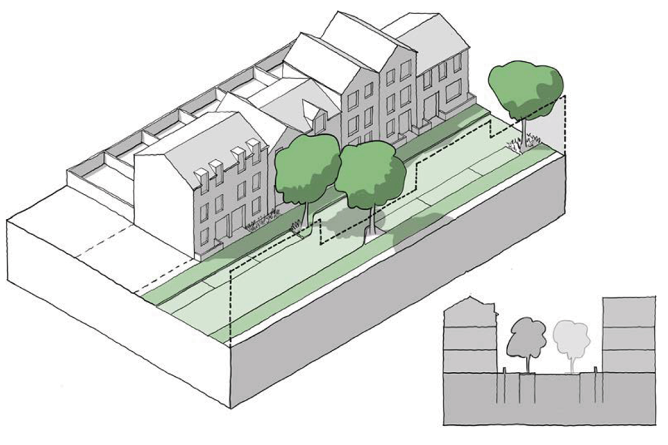
Figure 58. Local Streets: An example of a 14 meter wide urban street with three-storey buildings creating an enclosure ratio of 1:1.5.

Figure 59. Local Streets: An example of a 24 meter wide suburban street with two-storey buildings creating an enclosure ratio of 1:4.
[Alt text: Illustrative drawing. Two 3D line drawings and sections that illustrate the preceding figure text on local streets.
This first image shows three storey town houses fronting directly onto the street with back gardens, while the second image shows lower density two storey semi-detached houses set back from the street with front gardens.]
Enclosure: Will vary by area type: In urban neighbourhoods, streets feel comfortable where the width of the space is only a little wider than the height of the buildings. In suburban neighbourhoods the width of the street is likely to be at least twice that of the building height.
Frontage: Buildings can front onto the street and take their main access from it. In urban neighbourhoods, many of the buildings will be terraced. In suburban neighbourhoods, many of the buildings may be semi-detached or detached and they may have crossovers or drives.
Active frontage and supervision: In urban neighbourhoods and inner suburbs, active frontages will be permitted but not required. There will be eyes on the street. In suburban neighbourhoods, active frontages may be permitted or not permitted. Eyes on the street may not be a requirement for an area type with strongly planted plot boundaries.
Setbacks: Will vary by area type. In urban neighbourhoods, housing may be set back by between 0.5 and 3m to provide a privacy strip or small front garden. This may also accommodate a bin store and a low boundary wall, railing or fence. In suburban neighbourhoods, setbacks may be larger than this to provide larger front gardens.
Footways: The street should have pavements of at least 2m unobstructed width for pedestrians with crossings as necessary. Street furniture may be provided such as seating, appropriate to projected users, space and where clear access can be maintained. Further information on designing for footways can be found in Manual for Streets.
Servicing: Deliveries and refuse collection will take place from the front of the property. There may be a separate access to the back garden.
On-street parking: May be provided in designated bays where space is available.
Green infrastructure: Street trees may be provided on at least one side of the street within the parking zone. Verges/ swales/ rain gardens may be provided.
Cycle facilities: As traffic levels are low, segregated facilities are less likely to be necessary.
P.1.iii Tertiary Streets
138. In some area types there will be other existing or proposed street types that perform different functions and have different design parameters. It may be appropriate for design codes to be specific about these depending on local conditions.

Figure 60. Types of Tertiary Street: There are a wide variety of other street types that characterise existing development and may be used to inform new schemes.
-
Rural/village lanes: These have a distinctive character. They may not have separate footpath or street lighting and may have constrained vehicular access, depending on local character. Design codes may seek to extend this character, particularly where lanes are to be incorporated into new development.
-
Mews streets: Traditional mews streets provided access to the rear of large houses. They can be accessed through an archway from the main street and have no pavements.
-
Alleyways: Many historic towns and cities include a network of alleyways. They can provide established and well-used pedestrian routes that need to be preserved in new development. 19th century housing areas can include rear alleyways that provide access to back yards.
-
Back streets: A network of back streets provides access to the rear of properties for servicing. These are often narrow without pavements.
-
Burgage courts: Historic towns and villages can have burgage courts. These provide access into deep burgage plots and can be fronted by cottages. They provide access off the high street, often through an archway and may allow vehicle access.
- Closes and cul-de-sacs: Short residential streets to open up sites where through streets are not possible.
P.2 Social interaction.
139. Streets and other public spaces such as public squares have an important social function to bring people together and to act as a focus for community life. Parks and other green spaces described in section N1 also contribute towards social interaction. Special consideration needs to be given to safety, multi- functional and generational spaces and reducing the risk of crime.
P.2.i Meeting places
140. Many neighbourhoods include public spaces as focal points at the heart of the community. They may include city and town squares, market places and village greens. Squares can be green spaces enclosed by railings, or paved surfaces for use as markets and public events. All of these spaces provide informal settings for activities such as meeting, resting, playing, holding events and parking.

This is a set of three top down plan drawings showing different types of public square. They illustrate the following captions:
-
Village green: One of the oldest forms of public space. It is normally grassed with roads around its edge and also possibly a pub or local shop.
-
Town square: An example of a town square, with hard standing, roads on three sides, and opportunities for markets and other public events. This type of square would often be the setting for a public building and sculpture.
-
Garden square: An example of a garden square typically found in London but also common in new development. Roads on four sides enclose a green space bounded by railings.

3D line drawing and a 2D section showing a large public square fronted by a range of different buildings, lively with people, market stalls, public art and a carousel. It illustrates the principles of public space design set out in the preceding text.
-
Scale: Public spaces need to be appropriately sized and proportioned. In new development, it is good practice to identify suitable precedents to inform their dimensions.
-
Enclosure: The size of a square is informed by the scale of surrounding buildings. Typically, the enclosure ratio of the short dimension of a square is at least twice the height of the buildings.
Public uses: Squares may act as a focus for public uses such as educational buildings, churches, pubs, restaurants and cafes. They are also gathering space for uses that draw large numbers of people.
Events: Facilities can be provided for various types of event, ranging from outdoor stages and tiered seating to market stalls, or power supply and lighting.
Traffic: Squares can accommodate some local traffic around their edge, ideally not on all four sides.
Frontage: Buildings can frame a square, take their main access from it and provide a continuous building line around it.
Active frontage: Active frontages need to be provided around a public square, preferably at least two sides of it.
Setbacks: Buildings will normally be positioned at the back of pavement around the square.
Servicing: Deliveries may be from the rear of properties or from the square itself with provision being made for deliveries.
On-street parking: On-street parking may be accommodated either permanently or when not being used for other activities.
Green infrastructure: Trees may be provided within squares. The type of trees and their position will depend on the function of the square, so as not to compromise the flexibility of the space.
P.2.ii Multi-functional streets
141. Many high streets have been pedestrianised, and where this is done well, it can help boost trade and create a more welcoming environment. Pedestrianisation can be done in various ways – either full time, during shopping hours only or at weekends only. Alternatively, where full pedestrianisation is not appropriate, access for vehicles may be retained but the street design rebalanced to give more road space to walking and cycling. There are often concerns that reallocating road space will have a negative impact on business. However, evidence shows that people who walk and cycle take more trips to the high street over the course of a month than people who drive. Making access to high streets easier by walking and cycling has a proven economic benefit.
P.2.iii Home zones
142. Home zone principles can be applied on local streets. They are defined in guidance as residential streets where ‘people and vehicles share the whole of the street space safely and on equal terms, where quality of life takes precedence over ease of traffic movement’. Vehicle speeds are reduced to walking pace. They can form part of the street hierarchy in new development or be retrofitted into existing streets. Many homes zones use one-way streets and chevron parking to slow traffic and create space for planting and local play space.

Figure 63. Home Zones.
[Alt text: Illustrative photograph. The image shows the Abode development in Cambridge. The shot is taken looking down the centre of the street, which is an example of a shared surface but with different textures and finishes to denote different areas. Trees and planting are integrated into the street. Houses with pitched roofs line the street with materials of warm yellow brick, black weather boarding and black and tan roof tiles.
-
Surfacing: Home zones often include shared surfacing but can also include low kerbs and separately marked pavements.
-
Street furniture: Can create sitting areas and act as barriers for cars.
-
Play: Small play areas create community space.
-
Planting: The street can accommodate planters and trees.
-
Cars: Speeds are reduced to walking pace with parking potentially accommodated in chevron spaces.
- Signs: Should clearly mark the entrance to the zone.
P.3 Security and public space
143. Reducing crime has a significant impact on building strong communities and ensuring the long-term sustainability of a development. The increasing threat of terrorism also needs to be considered in the design of public spaces.
P.3.i Secured by Design.
144. Neighbourhoods need to be designed to make all people feel safe and to reduce the incidence of crime in accordance with the recommendations of Secured by Design which includes guidance for housing, commercial space, schools, hospitals and sheltered accommodation. Support and advice is available from the police through a network of Designing Out Crime Officers (DOCOs) across the UK. Secured by Design advice incorporates proven crime prevention techniques and measures into the layout and design of places and spaces.
145. Insecure places can disproportionately affect some of the groups with protected characteristics. Local authorities will need to take this into account when devising and implementing design principles, having regard to the Public Sector Equality Duty, under the Equality Act 2010, which includes the need to have due regard to eliminate discrimination, harassment, victimisation and any other conduct that is prohibited by the Act.

This is a 3D line drawing of a low density residential street at night. It illustrates the secured by design principles set out in the following text.
-
Access and movement: Places with well-defined routes, spaces and entrances that provide for convenient movement without compromising security.
-
Safe routes: Creating safe routes that are as straight as possible, wide, well lit, without hiding places and well maintained and overlooked for security and provide a sense of security for all users.
-
Structure: Places that are structured so that different uses do not cause conflict.
-
Lighting: Ensuring appropriate and non-obtrusive lighting levels are achieved.
-
Private space: Creating a clear separation between public and private spaces, avoiding public routes next to back gardens.
-
Surveillance: Places where all publicly accessible spaces are overlooked.
-
Ownership: Places that promote a sense of ownership, respect, territorial responsibility and community.
-
Physical protection: Places that include necessary, well- designed security features.
-
Activity: Places where the level of human activity is appropriate to the location reduces the risk of crime and creates a sense of safety at all times.
- Management and maintenance: Places that are designed with management and maintenance in mind, to discourage crime in the present and the future.
Counter terrorism
146. The design of town centres, shopping streets and other public spaces needs to take account of potential terrorist attacks. Preventing hostile vehicles reduces the risk of vehicle borne attack and road traffic collisions involving pedestrians. Urban design principles and detailed landscape design solutions need to be considered at the early design stages to mitigate risks.
Further guidance on Hostile Vehicle Mitigation is available in the References section. Local authorities should consult their local police Counter Terrorism Security Advisor for relevant advice.
Check list: Public space
Local design codes should consider:
P.1 Streets
- A framework plan showing the existing street hierarchy for the authority area.
- Guidance on the design of new - and the upgrade of existing - streets related to the area type that they run through and relating to Manual for Streets.
P.2 Social interaction
- Guidance on the design of public spaces and squares.
- Multi-functional streets and Home Zones including where they can be used and how they should be designed.
P.3 Security and public space
- Guidance on design to increase people’s feeling of safety and to reduce incidents of crime.
- Guidance on appropriate and proportionate security measures.
Use
Introduction
147. Sustainable places include a mix of uses that support everyday activities, including to live, work and play. Well- designed places have:
- a mix of uses including local services and facilities to support daily life;
- an integrated mix of housing tenures and types to suit people at all stages of life; and
- well-integrated housing and other facilities that are designed to be tenure neutral and socially inclusive.
148. Design codes could seek to facilitate a mix of uses that reflect local needs and support community life.
U.1 Variety and Activity
149. Successful places generally contain a mixed community and mix of uses creating variety and activity. The degree will vary within different area types, but opportunities need to be sought in all circumstances to make efficient use of land, promote a mix of uses that meet local needs and create vitality through activity in compact development.

Two 3D line drawings. The first is of a medium density mixed use block. The second shows a lower density residential block. They illustrate the following urban and suburban intensification options:
Fig 65. Urban intensification options:
- Development of airspace over retail units.
- Backyard development.
- Infill development on vacant site.
- Infill unit on corner slot site designed to avoid overlooking.
- Upward extension within height guidelines.
Fig 66. Suburban intensification options:
- Garden development accessed from the side of property.
- Redevelopment of existing units at higher density for apartments.
- Upward extension within height guidelines.
U.1.i Efficient use of land
150. Using land efficiently means getting the maximum possible benefit from a site or area, taking into account relevant constraints.
151. This can help to achieve desirable social and environmental outcomes, facilitate the efficient use of resources and infrastructure and reduce pressure on greenfield sites.
152. Efficient land use could involve:
- Co-locating higher density housing with shops, services and public transport nodes.
- Coding for the intensification of lower density areas that use land inefficiently.
- Providing substantial, accessible, useable green/public spaces rather than multiple small strips and verges.
- Consolidating surface parking infrastructure into multi-storey car parks or car barns.
- Building over surface car parks.
U.1.ii Mix
153. A mix of uses involves the co-location of different types of development within a single walkable area.
154. The correct balance of uses will help increase the amount of activity in an area throughout the day, reduce overall travel, encourage sustainable travel and support shops and services with a critical mass of people. This will contribute to the creation of sustainable and successful places.
155. Design codes could help to facilitate a mix of uses by:
- Coding for specific uses (if a desired mix is known).
- Coding for flexible building typologies in new development that would allow for changing uses over time.
- Flexibility of established use classes.
- Enabling the conversion of existing buildings for different uses.
U.1.iii Active frontage
156. An active frontage means that buildings have ground (and sometimes upper) floors with windows and doors facing onto the street, creating interest and activity. Related uses might include shops, cafés, commercial premises or services but can also include residential uses.
157. Active frontages can provide informal surveillance opportunities improving the safety of an area and creating vitality through the presence and interaction of people.
158. Active frontages are associated with uses that generate many visits, particularly on foot, over the course of the day. In a primarily residential area, active frontages might be achieved through doors and windows facing onto the street. In a local centre, this might be achieved by coding for active uses at ground floor.
159. Design codes could help facilitate active frontages by:
- Specifying a proportion of building frontage that should be active for each street.
- Specifying a proportion of active uses for a particular area.
- Specifying ground floor ceiling heights to allow flexibility of uses in town centres and high streets.
- Requiring new buildings to have main entrances and windows facing onto the street.
- Encouraging the inclusion of balconies and larger windows for higher density residential.
- Requiring commercial developments to use glazing at ground floor.
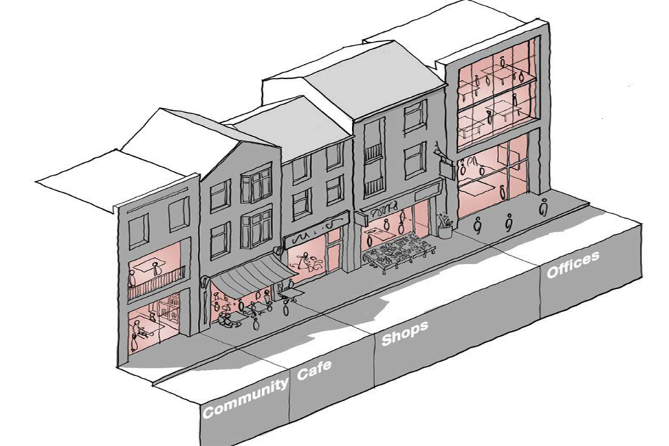
Figure 67. Active Ground Floor Uses: There are a variety of activities that can create an active ground floor in addition to shops, cafes, restaurants and bars. Co-housing and student housing schemes can include communal facilities for residents. Office foyers have large windows and can even include cafes and other activities. Studios and workshops for crafts people and small businesses can be located on the ground floor. Community uses can also be included on ground floors and ground floor residential accommodation can also be designed to relate well to the street.
U.2 Housing mix
160. Successful neighbourhoods contain a rich mix of people, including families and the elderly, young people and students, people with physical disabilities and those with mental health needs. This, in turn, requires a variety of housing in terms of tenure, type and construction.
U.2.i Housing for all
161. There are a wide variety of housing tenures and types with different user and operational requirements, that could form part of new development. Achieving the right mix will help to create diverse, equitable and resilient communities where people are able to access the homes they want or need.
162. The correct mix of tenures and types will depend on the socio-economic context of the local and wider area. Local plans and other local policies will include guidance around housing need and the provision of different tenures.
163. The design code could help facilitate an appropriate mix of tenures and fair approaches to provision by:
- Providing additional guidance about where the tenures required by local policy should be located.
- Illustrating the mix of tenures in an area. This could include a combination of the tenures set out opposite.
- Specifying tenure blind development (i.e. where there is no distinction between the visual appearance and general location of different tenures).
- Requiring the same shared entrances and facilities are available for all tenants within a building.
Figure 68. Toolkit of housing tenures
Social housing: Housing provided at controlled rents for people in housing need by registered social housing providers and local councils.
Affordable housing: Social rented, affordable rented and intermediate housing, provided to eligible households whose needs are not met by the market.
Private rented: Housing available at market rents, including institutional investors, are creating bespoke rental blocks in the Private Rented Sector (PRS) often with communal facilities.
Specialist housing: Independent living, sheltered housing, extra care housing, care homes, inter- generational housing and retirement communities and other specialist housing.
Housing for younger people: Specialist housing for younger people, student housing, co-living accommodation.
Supported housing: Specialist housing to meet the needs of vulnerable people.
Shared equity: Housing that is partly sold and partly rented.
Housing for sale: Housing built by private housebuilders for sale including various forms of discounted sale such as first-time buyer schemes and rent to buy initiatives.
Co-housing: That allows people to buy a stake in the development rather than an individual home. This is increasingly popular with community housing schemes.
U.2.ii Type
164. Housing type refers to the size, purpose and arrangement of housing.
165. There are a wide variety of housing types and achieving the right mix is another component (along with tenure) of helping to create diverse, equitable and resilient communities where people are able to access the homes they want or need.
166. The correct mix of tenures will depend on the socio-economic context of the local and wider area. Local plans and other local policies will include guidance around housing
167. The design code could help facilitate an appropriate mix of housing types by:
- Providing additional guidance about where the types required by local policy should be located.
- Requiring a particular mix of types in a particular area. This could include a combination of the types set out below.
- Allowing/encouraging the conversion of existing housing into a different type.
Houses: Self-contained units with ground level access. They can be terraced, semi- detached or detached, with narrow, medium or wide frontages normally with a garden to the front and rear. Special house types may be appropriate for higher density schemes. These can include courtyard units, mews blocks, corner blocks and house types that sit below or above other accommodation while maintaining a ground floor access.
Apartments: Self-contained dwellings accessed from communal space. The most common form is the single aspect apartment which can cause environmental issues in terms of light and ventilation. Gallery access and limited apartments per core can facilitate dual aspect apartments that address such issues.

This is a series of nine 3D line drawings of different house types. They illustrate the following:
- Terraced
- Semi-detached
- Detached
- Wide frontage
- Corner houses
- Town houses
- Courtyard houses
- Mews houses
- Specials
Live work units: All homes should preferably be designed with the flexibility to be used for homeworking. Live/work units go further by providing workspace on the ground floor, a flexible first floor and living accommodation above.
Shared housing: Including multi- generational homes and private rented schemes for single adults to share.
Specialist housing: Housing for older people and those with other needs. Retirement communities, independent living, sheltered housing, extra care, assisted living, care homes including nursing homes, residential homes and high dependency units.
Co-housing: Schemes can be made up of a combination of the units described above with shared meeting, dining and leisure facilities.
Self-build and Custom-build: Homes built to the plans or specifications decided by their occupants. Design codes can facilitate self and custom-build homes both on infill sites and on larger schemes where plot-based masterplans enable individuals to build or commission their own homes.

This is a simplified 3D line drawing of a three storey building. The side is "cut out" to reveal the interior of the space. Text at each storey indicates it's use: "live" on the top floor, "flexible" on the middle floor and "work" on the ground floor.

Figure 71. Custom-build homes: New homes built on serviced building plots where homes are designed or customised for the occupant and the purchaser has input into designs. Custom build can include different house types and tenures.
U.3 Community
168. Local community is fostered by a mix of housing and public spaces and the type of activities permitted within them. It is also nurtured by community involvement in design and management (see Lifespan section). It is important to provide a mix of community facilities integrated into the scheme, including schools, healthcare, other local facilities and community spaces.
U.3.i Schools
169. Schools and nurseries comprise an important part of the community facilities serving an area. They can provide a focus for community life and incorporate important facilities beyond educational uses. They can also create activity that supports local shops and other services. Guidance on the provision, land requirements and design of schools is provided by the Department for Education.
170. Schools need to be located to be as accessible as possible to the communities which they serve and to provide maximum support to local shops and services. There needs to be sufficient provision to serve local need where appropriate.
171. Design codes could support the positive delivery and integration of schools into the urban fabric by the following measures. Guidance on design codes for schools to be provided by the Department for Education.
- Suggesting locations for schools that maximise usability for the community and supports local shops and services, where appropriate.
- Providing guidance on factors that need to be considered when integrating a school into a neighbourhood (e.g. noise, traffic congestion, overlooking).
- Providing guidance on the design of schools, taking into account the following components:
Built form: Schools can have a key role in being nodes/markers and as public buildings could have a different character/scale/form from the main fabric of a settlement.
Building line: New school buildings could face onto streets and squares and could relate to the identified building line. Set-backs may be appropriate to create a setting for the building.
Height: Heights of school buildings will be determined by DfE guidance and could be appropriate to the area types in which they sit.
Access: There may be separate entrances for children and visitors, and the former will need to take account of school drop-off and collection while encouraging active travel with car use and parking reduced where possible. Entrances need to be from the street or public places.
Public and private space: A key issue is the management of public and private space. Ideally the setting of the school building and associated safeguarding measures would consider the transition from the street into the managed space of the school.

Figure 72. Urban School: In urban areas schools can be built on a number of storeys within a block structure.
[Alt text: Illustrative drawing. This is a 3D line drawing showing how a school can be integrated into a block in an urban context. The school follows the height and building line of the rest of the block (around four storeys). It is set back at the corner where the entrance is located. To the rear an open play space is provided on one of the upper storeys.]

Figure 73. Suburban School: In lower density areas schools occupy larger sites but still need to create a clear separation between public and private realm.
[Alt text: Illustrative drawing. This is a 3D line drawing showing how a school can be integrated into a block in a suburban context. It is integrated into the building line of the surrounding houses but is set back a little. The fields and sports pitches occupy the centre of the block, backed onto by the surrounding back gardens.]
U.3.ii Community facilities
172. Community spaces are those that can be used by the wider public or specific resident groups for a range of activities. They play a vital role in the social life of communities, acting as a self-organising public service and supporting community cohesion. They can also create activity that supports local shops and other services.
173. Such spaces need to be located to be as accessible as possible to the communities which they serve and to provide maximum support to local shops and services. There needs to be sufficient provision to serve local need.
174. Design codes could support the positive delivery and integration of community spaces into the urban fabric by:
- Requiring the provision of community spaces within new development dependent on scheme size and mix.
- Providing guidance about the location and design of community spaces to maximise accessibility to the community, minimise disruption and ensure security/safety.
- Allowing/encouraging the conversion of existing buildings to community uses.

This is a 3D line drawing of a neighbourhood viewed from above, comprised of a number of blocks. It illustrates the facilities described in the preceding text.
1. Cultural and community facilities: village halls, community hubs and other cultural facilities.
2. Local shops: The design code needs to provide guidance for the design of and access to local shopping facilities.
3. Pubs/cafés: Local shops can include cafés and other food and beverage uses where people can meet and, increasingly, work.
4. Medical facilities: All areas need medical facilities, including doctor’s surgeries, district nurses, dentists and chemists. GP’s mostly work in group practices in health centres, so only the largest schemes will be required to include them. Health facilities need to be in accessible locations at the heart of a community and planned in co-operation with relevant health and care organisations.
5. Places of worship: New buildings for religious worship are an important community function as places of congregation and community and need to be integrated into new development.
6. Homeworking hubs: Homeworking employees can support local facilities and there may also be scope to provide facilities to support home workers. Hubs include meeting spaces, shared resources such as printers, and even a delivery address.
[Alt text: Illustrative drawing. This is a 3D line drawing of a neighbourhood viewed from above, comprised of a number of blocks. It illustrates the facilities described in the preceding text.]
U.3.iii Local services
175. There are a number of other services that provide a vital function in supporting community life and reducing the need for travel (U15).
176. Ideally people need to be able to meet most of their day to day needs within a walkable radius of their home.
177. Design codes could support the positive delivery and integration of local services into the urban fabric by:
- Requiring the provision of local services within new development dependent on scheme size and mix.
- Providing guidance about the location and design of local services to maximise accessibility to the community and support for existing shops and services.
- Allowing/encouraging the conversion of existing buildings to local services.
Check list: Use
Local design codes should consider:
U.1 Variety and activity
- The intensification of existing areas including in which area types it is appropriate and including guidance on how it should be done.
- The provision of a mix of uses in each area type and on how this should be measured.
- The provision and design of active frontages for each area type.
U.2 Housing mix
- The mix and integration of housing tenures and achieving tenure-blind development.
- The mix of house types and tenures.
- Live-work units, how they are defined and where they can be located.
U.3 Community
- The design and location of urban and suburban schools.
- The design and location of community facilities.
- Accessibility, mix and design of local services.
Homes and buildings
Introduction
178. Well-designed homes and buildings are functional, accessible, inclusive and sustainable. They provide attractive environments that support the health and wellbeing of their users. They meet a diverse range of needs, are adequate in size, fit for purpose and adaptable. They relate positively to the spaces around them and allow for easy operation and servicing.
179. Design policies can support the development of well-designed homes and buildings by addressing space standards, accessibility, adaptability, lighting, privacy, security and the delineation of public and private spaces.
180. The requirements in this section need to be balanced against other design code considerations and the detail design of inter-related requirements resolved at project level.
H.1 Housing quality
H.1.i Space standards
181. Space standards are minimum requirements for internal space within new dwellings and include Gross Internal (floor) Area, and dimensions for key parts of the home including bedrooms, storage and floor to ceiling height. They help to ensure that new homes contribute to the health, family function and wellbeing of residents.
182. Space standards are set at a national level by the Nationally Described Space Standards 2015 and are optional for local planning authorities to adopt, subject to local plan viability testing and approval by the Planning Inspectorate.
183. Design codes can support the delivery of housing quality by including Nationally Described Space Standards. These need to be included in local plans or design codes that are adopted in local plans.
H.1.ii Accessibility
184. Accessible homes can be easily reached, entered and used by everyone, regardless of age and physical ability. Providing accessible housing is important in ensuring that the needs of older and disabled people are met, as well creating the flexibility for homes to meet the changing needs of individuals and families at different stages of life. Doing so allows people to remain within the community, contributing to their individual wellbeing and the social cohesion of the area.
185. At a national level building regulations set out three categories of accessibility and local planning authorities are expected to set requirements for accessibility that reflect local needs. Design codes can support the delivery of accessible housing by requiring a percentage of development, or development delivered in certain areas, to meet the standards for the higher categories (2 and 3). These need to be included in local plan policy and can be referenced in the code.
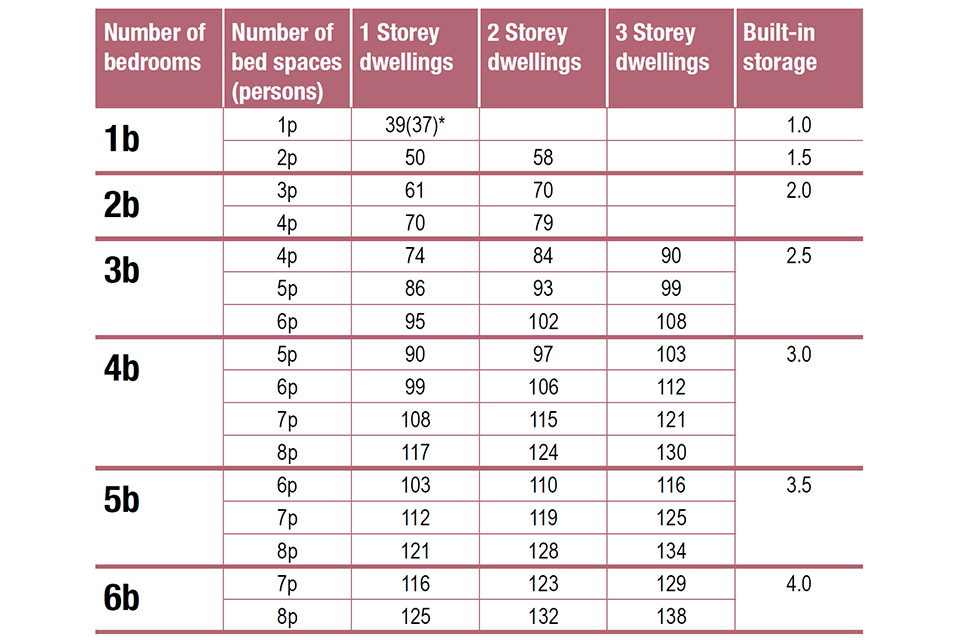
Figure 75. Nationally Described Space Standards.
[Alt text: This is a table setting out the Nationally Described Space Standards. It shows the number of bedrooms, number of bed spaces, number of storeys and amount of built in storage required along the top.
It is not configured in a way that is conducive to the use of reading software, however the information has been extracted from the Nationally Described Space Standards document on the gov.uk website, and if you require more detailed information about the standards, an accessible document can be requested in a range of formats by emailing alternativeformats@communities.gov.uk.]
H.2 Health and wellbeing
186. A considerable amount of time is spent daily in the home environment. Internal home quality and its immediate surroundings are key determinants of the health status of the general population and those from vulnerable and protected characteristics groups.
187. The built environment has a significant impact on people’s health and wellbeing. This relates across the design code with regard to walkable neighbourhoods, access to greenery and recreation, attractive buildings and public spaces, space standards, and strong communities. There are also specific elements relating to the impact of the design of homes and buildings that affect wellbeing including daylight, aspect and privacy, noise mitigation, security and access to private outdoor space.
H.2.i Lighting aspect and privacy
188. Good quality housing creates a pleasant indoor environment with adequate levels of natural lighting, and sunlight, without problems of overheating, good quality ventilation, privacy from overlooking and minimal noise impact. In preparing design codes, consideration needs to be given to:
- Internal layouts that maximise access to natural daylight.
- Appropriate levels of glazing to ensure adequate internal lighting without problems of overheating (see Section R1).
- Dual aspect apartments particularly on north facing blocks.
- Application of privacy distances and their effect on layout.
- Front gardens and privacy strips.

This is a 3D line drawing of a residential block. It shows examples of the privacy distances set out in the preceding text. e.g. 10 meters between the side of one house and the rear of another, or 15-20 meters between the rear of two houses.

Figure 77. Dual Aspect Apartments: 1. Single aspect flats should not face north. 2. Apartments accessed from a balcony have two aspects. 3. Walk-up apartments can also be designed so that every apartment has two aspects.
[Alt text: Illustrative drawing. This is a top down plan showing the three configurations of apartments set out in the preceding text. The first is a set of single aspect apartments arranged along a central corridor with flats facing west and east respectively. The second shows a row of dual aspect apartments accessed by a balcony. The third shows walk up apartments and illustrates how the configuration can create dual aspect corner apartments.]
H.2.ii Security
189. People’s feeling of security within their home is influenced by the design of the home and the way that it relates to its neighbours. This also relates to gardens and the security of parked cars and bikes.
190. The layout of dwellings should ensure that homes and places are easy to move around and safe and secure as set out in Secured by Design guidance. Layouts need to ensure natural surveillance from buildings to public spaces, encourage community interaction, engagement and participation and environmental control.
191. Housing plots need to include fences to the rear and defensible space/front gardens at the front with a boundary treatment or planting to keep people away from windows.
192. In suburban area types cars parked on plot will be more secure. Where rear parking courts are necessary, consideration needs to be given to security, through natural surveillance or gating. Bike parking should also be secure and where possible in the curtilage of the dwelling.

This is a 3D line drawing of a semi detached house at night. It illustrates the principles set out in the preceding text on security.
H.2.iii Gardens and balconies
193. Access to external private space is important for people’s wellbeing. Design guides may include minimum standards for the provision of private open space.
194. This may include the size of back gardens related to the size or expected occupancy of the home. It may also include a requirement for a setback of the home from the street (see Section B2:ii) and provide guidance for how this is treated including the boundary treatment, such as a wall, hedge or fence.
195. Guidance may also be provided about the provision and size of balconies on apartments.

This is a 3D line drawing of a house with a small front garden and larger back garden. The back garden contains a tree, play equipment and a small shed. It illustrates the preceding text on gardens and balconies.
Communal gardens
196. Communal, semi-private space can be provided for residents within urban blocks which is not accessible to the general public and is generally situated with perimeter blocks accessible either by communal entrances or direct from properties.
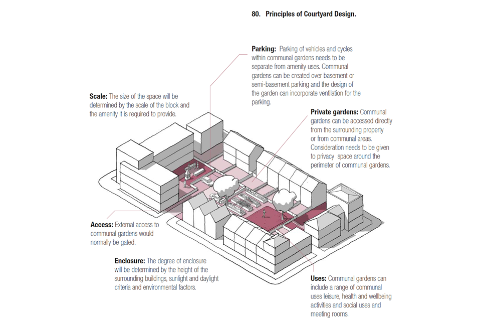
This is a 3D line drawing of a residential block, with various typologies of housing around it's periphery. It shows the principles of courtyard design and illustrates the following captions:
Scale: The size of the space will be determined by the scale of the block and the amenity it is required to provide.
Access: External access to communal gardens would normally be gated.
Enclosure: The degree of enclosure will be determined by the height of the surrounding buildings, sunlight and daylight criteria and environmental factors.
Parking: Parking of vehicles and cycles within communal gardens needs to be separate from amenity uses. Communal gardens can be created over basement or semi-basement parking and the design of the garden can incorporate ventilation for the parking.
Private gardens: Communal gardens can be accessed directly from the surrounding property or from communal areas. Consideration needs to be given to privacy space around the perimeter of communal gardens.
Uses: Communal gardens can include a range of communal uses leisure, health and wellbeing activities and social uses and meeting rooms.
Check list: Homes and buildings
Local design codes should consider:
H.1 Housing quality
- Whether the Nationally Described Space Standards are to be applied locally. This is subject to tests on need and viability and should be referenced to the local plan.
- Whether local policy will include a requirement for homes to meet Building Regulations M4(2) accessible and adaptable standard or M4(3) wheelchair user dwelling standard.
H.2 Health and wellbeing
- Measures to promote the health and wellbeing of residents, including:
- Privacy distances.
- Internal daylight and sunlight.
- Dual aspect homes.
- The application of Secured by Design principles to the home and its surroundings.
- The provision of private open space including gardens and balconies.
- The provision and design of communal open spaces.
Resources
Introduction
197. Well-designed places and buildings conserve natural resources including buildings, land, water, energy and materials. Their design responds to the impacts of climate change by being energy efficient and minimising carbon emissions to meet net zero targets by 2050. It identifies measures to achieve: mitigation, primarily by reducing greenhouse gas emissions and minimising embodied energy; and adaptation to anticipated events, such as rising temperatures and the increasing risk of flooding.
198. A compact and walkable neighbourhood with a mix of uses and facilities reduces demand for energy and supports health and wellbeing. It uses land efficiently so helps adaptation by increasing the ability for CO2 absorption, sustaining natural ecosystems, minimising flood risk and the potential impact of flooding, and reducing overheating and air pollution.
199. Forthcoming changes to environmental performance standards set out in the Future Homes Standard will be included in the Building Regulations and applied nationally in order to meet zero- carbon targets. The following elements can be addressed locally, and these can be included in design codes.
R.1 Energy
R.1.i Energy hierarchy
200. The Energy Hierarchy is a classification of energy options, prioritised to assist progress towards a more sustainable energy system. Design codes can include a local energy hierarchy based on energy efficiency standards, renewable energy sources and renewable energy networks, following a ‘fabric first’ approach.
R.1.ii Energy efficiency
201. Local authorities can set policies for higher energy efficiency standards for their area or in relation to specific development sites in local plans or design codes that are adopted in local plans. The materials, construction and orientation of buildings dictate their energy efficiency. There are multiple ways of reducing energy waste. In developing policies, consideration should be given to improving energy efficiency, which may address the selection of materials for thermal and solar performance, retrofitting existing buildings, design and orientation construction techniques and assessing whole life costs. These requirements need to be integrated with other design code considerations and the detail design of inter-related requirements resolved at project level.

This is a 3D line drawing of three rows of terraced housing, with coloured overlays illustrating the angles of summer and winter sun. It is accompanied by the following explanatory text:
Passive design: The layout and orientation of new buildings contributes to reducing their energy needs by avoiding overshadowing, maximising passive solar gain, internal daylight levels and ventilation.
Solar energy generation: The layout and orientation of roofscapes need to maximise opportunities for solar PV generation with south-facing roof space and the use of reflective surfaces.
Other technologies: consider adequate space in masterplanning and plots for homes for new and emerging technologies such as ground and air source heat pumps for example.
Orientation: Ensuring good levels of natural lighting to habitable rooms whilst minimising the risk of overheating, provides benefits for both health and energy efficiency. Careful modulation of heights and roofscape can maximise the sunlight to each unit. South facing single aspect homes that lead to overheating and north-facing single aspect flats needs to be avoided.

Figure 82. Form Factor: Is the proportion of floor area to external wall area and can have a significant impact on energy efficiency. Urban building forms such as terraces and apartments minimise heat loss with a low form factor.
[Alt text: Illustrative drawing. This is a 3D line drawing showing a series of simplified buildings of different height and composition. It illustrates the preceding text by showing how the ratio of floor area to external wall area can vary between: a bungalow (2.8), a two storey detached house (2.3), a two storey terrace (1.3) and an apartment within the centre of a building (0.8).]

Figure 83. Micro-climate: Schemes needs to consider micro-climate, particularly wind impact on exposed sites or where taller buildings are proposed. This affects the usability of the public realm and the energy demands of buildings.
[Alt text: Illustrative image. This image shows an example of how microclimate analysis can be undertaken, in this instance by using wind modelling software. Coloured lines flow through a simplified 3D digital model of an urban area. The lines are blue where the intensity of the wind is low, and progress toward red in areas where the intensity of the wind is high, for example, between a series of tall buildings.]

This is a 3D line drawing of a block comprised of 2 and three storey houses. The drawing illustrates components that could be integrated into a low energy neighbourhood and includes the following captions:
[Alt text: Illustrative drawing. This is a 3D line drawing of a block comprised of 2 and three storey houses. The drawing illustrates components that could be integrated into a low energy neighbourhood and includes the following captions:]
Low renewable energy: Delivered through air, water and ground source heat pumps.
Retrofitting: Upgrading the energy performance of existing houses.
Solar PV panels: Using south-facing roofs.
Energy centre: Local battery storage linked to the grid.
Electric vehicles: Charging points as part of on-street bays.
Waste recycling: Communal bins with underground storage.
Local energy networks: Linking renewable energy sources to local heat and power networks.

Illustrative photograph. Close up of a row of windows on a modern building, with natural glazed manually controlled ventilation at the top and bottom of each window.
202. The design of windows needs to consider orientation to balance heat loss and beneficial solar gain, daylight and sunlight. Southern-facing glazing can be beneficial in contributing to overall energy demand in winter. It can lead to overheating in summer and excessive heat loss on cold cloudy days in winter. Glazing needs to be sized appropriately for context and passive measures such as external shading devices or provision for future installation of shading devices needs to be considered to reduce reliance on mechanical ventilation.
R.1.iii Neighbourhood energy issues
203. Some energy issues are most appropriately dealt with at the level of the neighbourhood rather than at building level. Design codes can address neighbourhood level issues that contribute to meeting energy efficiency targets, support supply and demand at the local level and reduce transmission losses. See Figure 84.
R.2 Sustainable construction
204. Sustainable construction is the practice of creating buildings using processes that are environmentally responsible and resource efficient. Design codes can include guidance on sustainable construction including embodied energy, approach to construction and use of water.
R.2.i Embodied energy
205. Embodied energy is the energy consumed by all the processes associated with the production of a building.
206. Reducing embodied energy can be achieved by remodel and reuse of buildings where possible rather than rebuild, using low energy materials, designing to use materials efficiently, reducing the energy used in construction, the re-use of materials and design for disassembly and adaptability so that the carbon locked in the building can be retained or reused in future. This can be achieved by:
- Reuse and refurbishment in preference to new construction.
- Embedding circular economy principles to reduce embodied carbon / energy and reduce waste.
- Energy used in construction. Reuse of materials.
- Design for disassembly.
- Foundations that accommodate trees.
R.2.ii Sustainable construction
207. All demolition and construction processes and materials production and application have environmental impacts. In addition to embodied energy, issues relate to the impacts of extraction, pollution, ozone, water extraction, and waste disposal. Design codes can include standards and guidance that address these issues.
R.2.iii Modern Methods of Construction
208. ‘Modern methods of construction’ is a term that embraces a range of off-site manufacturing and on-site techniques that provide alternatives to traditional housebuilding. Such techniques can contribute to the efficient use of resources. Design codes could encourage innovative methods of off-site construction and modular production to improve building performance, productivity, waste reduction and design for the circular economy. Design codes can include guidance that supports modern methods of construction by setting regular plot widths and encouraging the replication and repetition of plan types and layout elements. They can be used to limit requirements that make these methods more difficult to apply, such as excessive variety of form where this does not contradict the rhythm, building form and variety of the local context.
R.2.iv Water saving
209. The design of buildings and places can contribute to the efficient use of water. Climate change and associated weather events mean that water supply is becoming less predictable and areas of the UK are subject to water stress. Design codes can provide guidance and regulation around water saving which may address rainwater harvesting, dual potable and grey water recycling systems and requirements for “water neutrality” for new development and include reference to Optional Technical Standards for water efficiency standards.
Check list: Resources
Local design codes should consider in the context of relevant local plan policies:
R.1 Energy
- Energy efficiency standards and whether/how they apply to all or part of the area, if exceeding building regulations.
- Neighbourhood energy design including passive design, orientation and form factor.
- Renewable energy strategy.
- Local low energy networks.
R.2 Sustainable construction
- Embodied Energy targets.
- Whole life carbon targets.
- BREEAM or other best practice targets as appropriate.
- Water saving measures and how they can be achieved.
Lifespan
Introduction
210. Well-designed places sustain their beauty over the long term. They add to the quality of life of their users, and as a result, people are more likely to care for them over their lifespan. They have an emphasis on quality and simplicity.
211. Places designed for long-term stewardship are robust and easy to look after, enable their users to establish a sense of ownership, adapt to changing needs and are well maintained.
212. Design codes can address a number of factors that influence the lifespan of places.
L.1 Stewardship
L.1.i Management plan
213. Management and maintenance of places incorporate the processes associated with preserving their quality or condition. Good management and maintenance contribute to the resilience and attractiveness of a place and allows communities to have pride in their area.
214. In preparing design codes consideration needs to be given to:
- Management of public spaces, including streets and open spaces that will be adopted by local authorities and highways authorities, and shared spaces where these may be jointly or privately managed.
- Long term management plans for new development which might include individual residents and businesses managing private space, adoption by a public authority, the use of management companies or management by the community.
- Areas for adoption with information on layout, materials, construction details and landscaping.
L.1.ii Participation in design
215. A process for community participation in the production of codes is set out in Part 1.3. It is also important that participation is integrated into the process of developing masterplans for individual schemes.
216. Processes of participation, consultation and co-design improve transparency, help to build trust, allow for valuable local knowledge to be gained, increase a sense of ownership over the completed development and help to build community cohesion and stakeholder buy-in.
217. Design codes can support meaningful participation by requiring and providing guidance on participatory processes for new development.

Figure 86. Management Plan:
[Alt text: Illustrative drawing. The image relates to the preceding Figure 81 text. The drawing shows a top down view of a neighbourhood comprised of multiple blocks and landscaped areas. The plan colours the different management approaches set out in the preceding figure 81 text as different shades of purple. E.g. land within a courtyard block is dark purple to denote that it will be managed by a management company, while private gardens are left white to show that they will be managed by householders.]
L1.iii Community management
218. Community management is the management of a common resource by the people who use it through the collective action of volunteers and stakeholders. The community management of neighbourhoods is a valuable way of engendering a sense of ownership and responsibility as well as building social cohesion.
219. In preparing design codes, consideration can be given to how a strategic approach to community management and stakeholder engagement can be facilitated:
- Informal community management groups. Neighbourhood Planning Groups.
- Community management of public spaces.
- Community management of buildings and facilities.
- Community management of local energy networks.
- Community Land Trusts.
- Community housing such as cooperatives and co-housing.
Check list: Lifespan
Local design codes should consider including:
L.1 Stewardship
- Stewardship plan and when it will be required.
- Guidance on adoption of public areas.
- Levels of community engagement expected prior to a planning application.
- Guidance on facilitating community management.
Community engagement
Introduction
220. When preparing design codes, communities need to be involved at each stage of the process. The advice set out below needs to be considered in order to gain measurable community support for design codes. It needs to be proportionate to the scale and location of the development, recognising that some aspects of the development process are complex, some community groups are harder to reach, and that the occupants of new development are hard to identify. The form and approach for community engagement needs to be decided locally and co-designed with community groups. Local planning authorities should refer to planning practice guidance on plan-making, including the Statement of Community Involvement.
221. The community involves all people living and working in and around the area for which the code is being produced together with local interest groups, stakeholders and elected representatives.
222. The consultation process will involve:
- identification of the areas where the code will apply.
- definition and mapping of area types.
- masterplanning of development areas.
- content of the design code.
- application of the design code and how it influences individual schemes.
223. The process should be transparent and collaborative and precede each stage of the design code production. Engagement activities should be appropriate to the scale of the relevant area, with some elements of engagement taking place across the authority, and some at the settlement and neighbourhood level, to match stakeholder interests. At each stage, it should be easy for participants to engage with the process and see how their inputs have been used to develop the next iteration.
Tools and techniques
224. The guidance set out in Planning Practice Guidance, Design: Process and Tools, provides advice on how methods of engagement should be appropriate for access by all people. There are a range of in-person and digital engagement tools that can be used. Each have advantages and disadvantages for reaching different sections of the community. Using a combination of different techniques should be considered to reach the maximum number and range of people.
225. New digital technologies and applications are being developed and the process for engagement and measuring support will evolve over time. Local planning authorities will need to apply a balance of face to face and digital techniques appropriate to their circumstances and the type and scale of development.
87. Engagement tools (breakout box)
-
Visual preference surveys: to understand buildings, places, and streets that local people prefer, dislike or would like to improve.
-
Place assessment tools: such as tools like Placecheck and Spaceshaper.
-
Structured workshops and charrettes: hands-on events to explore the challenges and opportunities of a site or area, analyse options or develop design proposals at various stages in the process.
-
Community panels or forums: to ensure the voice of the community is considered through formal and informal structures.
-
Drop in events and exhibitions: to provide the opportunity to discuss the proposals with the consultation team and provide feedback in-person or via a questionnaire.
-
Design review panels: for peer group review at key stages to test the content and application of design codes. These could include community representation and professionals that are knowledgeable about the area for coding.
-
Digital engagement tools: The use of digital techniques can help to engage with hard to reach groups in the community, such as younger people, and can be used in addition to in person techniques referred to above.
-
Social media platforms, apps, email campaigns and websites: can be used to promote in person events but could also be used to share information, allow online participation in consultation processes and get feedback.
-
Digital models of design codes and their context, area or sites: to help to visualise concepts and the wider effects of development. These might include the use of gaming platforms to engage younger audiences in exploring spatial design.
-
Other visualisation techniques for three dimensional models: to provide the community with a visual appreciation of the proposals.
-
Community level data gathering: to gauge levels of support for particular ideas along with accessible, transparent representation so the community can see the views of the whole community reflected statistically.
Who is responsible?
226. This will depend on the scale at which the code is being considered. The engagement process for the design code at the authority level may be set up and managed by the local planning authority, while for specific development sites, the developer may be expected to manage the process.
227. The team responsible for producing a code will need to be an inter-disciplinary team of built environment professionals and may include architects, landscape architects, urban designers and local planning authority officers.
228. Independent facilitators may be appointed to offer design capacity-building to support community engagement and help build a shared understanding through the design process. Specialists in community engagement processes such as community planners could act as an interface with the local planning authority or the developer.
Initial engagement
229. Those leading the engagement will need to build the knowledge of the community about the purpose, application and development of design codes. It is important to provide participants with the right tools and information to engage fully. This could involve training at the outset to raise awareness and build skills. There may be a need for a period of networking, research and conversations to build a map of key interests and stakeholders. Initial engagement may include the actions set out in the box opposite.
88. Initial engagement (breakout box)
- Meeting with community representatives, stakeholders, councillors, neighbourhood planning groups, and external consultees to explain the process and the role of a design code.
- Surveying local hopes, preferences and fears as widely as possible.
- Set up community panels or forums to represent the views of local communities in the development of the design code.
- Get early buy-in from developers and landowners linked to proposed development sites and to agree roles and responsibilities.
- Publicise the process widely, with an emphasis on groups whose views may have been under- represented in the past.
Community events and facilities
230. Engagement may need to take place through a combination of workshops and interactive events as well as drop-ins and exhibitions. Community events need to cover geographical areas that the community can relate to. This could be the wider local planning authority area, although it is likely that separate workshops will be needed for different places. Workshops would be necessary for each stage of the process.
231. Engagement processes can have social benefits that extend beyond the task being undertaken, such as strengthening community cohesion and making connections between people who might not otherwise have met or interacted. Community engagement enablers may work closely with established organisations and groups within the community to organise events.
Measuring community support
232. Community engagement techniques that involve the maximum number of local people from all sections of the community and demographic profiles will need to be used to develop design codes, in order to structure engagement and demonstrate community support. Processes will need to be used that are appropriate for their context and circumstances, and those leading engagement will need to consider how they can demonstrate measurable community representation and support to ensure codes are based on what is popular locally, on the basis of evidence.
233. Activities that achieve this will need to be determined locally. Established techniques such as Enquiry by Design, BIMBY (Beauty in My Back Yard), Planning for Real and new emerging community engagement techniques, can be employed to deliver provably popular places that have measurable community support. The use of digital technology and social media platforms can support this.
Appendix 1. Area Type worksheet
This worksheet provides a series of questions, organised by theme, to inform the analysis and development of area types.
Movement
How would you characterise the street network:
- Fully connected, most streets link at either end to other streets
- Most local streets are cul- de-sacs
- A mix of the two
How much of the area is within a five minute walk of bus stops?
- All
- The majority
- Very little
Nature
How much of the area is within a five minute walk of a local park?
- All
- The majority
- Very little
What proportion of the streets have street trees?
Built form
What is the average density of housing development?
What is the average plot ratio?
How would you characterise the block structure:
- Regular perimeter blocks
- Informal perimeter blocks
- Row blocks
- Courtyard blocks
- Mews blocks
- Cul-de-sacs
- Mixed
What is the average set- back of buildings from the back of the pavement?
What is the character of the building line:
- Straight/curved/informal
- Variation
- Compliance
What is the predominant building height:
- Eaves height and level of variation
- Maximum height and level of variation
- Are there tall buildings present?
Identity
What is the palette of local materials: walls/roofs/windows?
- Local building features: window shapes, porches, bays, entrance features, balconies
- Is the roof form varied or regular?
- Boundary treatment to front gardens: wall/fence/railings/hedge
How would you describe the predominant architectural style, is this regarded locally as positive or negative?
Public space
For each of the following streets describe the character and measure the average width, building height, enclosure ratio and active frontage:
- Primary streets
- High streets
- Secondary streets
- Local streets
- Tertiary streets
Use
Are there signs of intensification having taken place?
How would you describe the mix of uses:
- Mostly housing
- Housing with occasional other uses
- Mostly employment
- Mixed
How would you describe the mix of housing?
Homes and buildings
What type of gardens do most houses have and do apartments generally have balconies?
What is the typical privacy distance?
Appendix 2. Area Type Matrix
Example of an Area Type Matrix: These are the elements of the Code that may differ by area type.

Example of an Area Type Matrix: These are the elements of the Code that may differ by area type.
[Alt text: The area type matrix is set out as a table with the different area types along the top, and a selection of the various elements of a design code outlined in this document listed down the left hand side. The idea being that in the production of a design code, the table could be populated with the different settings for each area type.]