Matching STATS19 collisions to a road network: feasibility
Published 24 September 2026

© Crown copyright 2026
This publication is licensed under the terms of the Open Government Licence v3.0 except where otherwise stated. To view this licence, visit nationalarchives.gov.uk/doc/open-government-licence/version/3 or write to the Information Policy Team, The National Archives, Kew, London TW9 4DU, or email: psi@nationalarchives.gov.uk.
Where we have identified any third party copyright information you will need to obtain permission from the copyright holders concerned.
This publication is available at https://www.gov.uk/government/statistics/matching-stats19-collision-data-to-a-road-network-feasibility/matching-stats19-collisions-to-a-road-network-feasibility
About this report.
This feasibility study describes work by the Department for Transport road safety statistics team to test whether each STATS19 collision point can be matched to a national road network. The recorded collision coordinates are not moved. The method assigns the best matching road link identifier, and a link confidence score, while retaining the original STATS19 location.
The report explains the purpose of the work, the datasets and matching method used, the quality checks applied, and the proposed use and release of any network-derived attributes.
Because the original coordinates are retained, existing uses of STATS19 location data are unaffected. Any matched-link identifier or network-derived variable would be additional, and could facilitate further uses of the STATS19 data. While the underlying network information may not be shareable, it is hoped that it would allow further linkage to other fields which could be, or the publication of aggregated statistics.
1. Summary
STATS19 contains a recorded point location for each reported injury collision and police-recorded road attributes such as road class, road number and speed limit. These attributes can be incomplete or inconsistent. This study explores whether the collision point can be matched to a plausible Ordnance Survey (OS) network road link (without changing the recorded coordinates) so that road information can be validated and, where appropriate, supplemented.
This feasibility study shows that, based on final collision data for 2025:
- matching road collisions to the Ordnance Survey National Geographic Database RoadLink for 2025 data produces reasonable results overall, sufficient to continue development of this approach.
- over 99% of collisions were matched to a network link and of these matches, around 99% were deemed as of acceptable quality (based on manual review of a sample of records)
- the matched data offers potential to provide some insight into consistency of police-recorded and OS data. For example, results show there is good agreement between police and OS coding of road class, and police coding of speed limit agrees with the data available via OS for around 80% of collisions
Given the results of this study, the proposed way forward is to incorporate an annual network matching into the road safety statistics publication processes, from 2026 onwards, aligned with production of final annual STATS19 data:
- an appropriate version of the network will be chosen (for example, as it exists at a given date, such as end May of the data year)
- during data collection and validation, network-based checks will be used support validation and identify issues to feed back to police force data suppliers
- final 2026 data would be matched to an agreed road-network for use in statistics published in summer 2027 (subject to any licensing decisions)
2. Introduction
What do we mean by network matching?. In this feasibility work, “matching” means comparing a STATS19 collision point with one or more nearby road network links and using a set of rules to decide whether the collision is close to a plausible road link, and if so which is most plausible, based on degree of agreement of attributes between the police and network data.
STATS19 contains a recorded point location for each reported injury collision and police-recorded road attributes such as road class, road number and speed limit. These attributes can be incomplete or inconsistent. This study explore whether the collision point can be matched to a plausible OS road link, without changing the recorded coordinates, so that road information can be validated and, where appropriate, supplemented.
2.1 Aims of road network matching
The aims of this feasibility study include:
- to assess whether STATS19 collision points can be reproducibly assigned to a plausible road link without changing the recorded coordinates
- to test whether the matched network information can strengthen validation of collision location, road class, road number and related fields (for example through identification of issues to query with police force data providers)
- to assess whether selected road-network attributes and link identifiers could support future aggregate analysis or linkage, subject to data quality and OS licensing condition.
Potential enrichment is secondary to validation. No network-derived variable will replace police-recorded information without review, and any release will depend on a defined quality threshold, clear metadata and confirmation of OS intellectual-property conditions.
A further proposed use, over the longer term, is linkage to other road datasets through a stable road-link identifier, for example traffic data and the developing rural-road classification. This could support aggregate casualty count and rate analysis, subject to compatibility between network versions, and licensing.
2.2 Choice of network
OS NGD RoadLink was selected for the feasibility study because DfT can access it through the Public Sector Geospatial Agreement, it provides detailed national road geometry and attributes, and it is related to the mapping used in the CRASH system used by many police forces to provide STATS19 data to DfT. In future, the road safety statistics team will agree the appropriate network product and version with the DfT roads geography team, taking account of the networks already used across road statistics, update timing, historic consistency and production support.
Because OS NGD is not an open dataset, the Department will confirm with OS which derived attributes, identifiers and aggregate outputs, if any, could be published or shared under licence. This will be explored further as the work progresses.
2.3 Related work
This work builds on road-network matching and validation developed by the DfT roads geography team for work to assess the performance of the Major Road Network (MRN), which developed a confidence score approach to link collisions to the MRN network. The road safety application adapts that approach to all STATS19 collision records.
Related approaches are also used by National Highways, the Road Safety Foundation, other road-safety organisations and researchers. The specific purpose here is to develop a method that DfT can use before annual STATS19 data are finalised, to support validation.
3. Methodology
This section outlines how a collision point is compared with nearby road links and assigned to the most plausible link. The recorded collision point is retained unchanged throughout.
During the past year, road network information has been used to validate STATS19 collision location information, where the method asks whether there is any plausible road link near the collision point and whether nearby links are consistent with the STATS19 road class and road number fields. Any discrepancies (collisions not near a road, or with non-matching road class or road number) have been reported back to police force data providers to check and amend as required.
The feasibility study goes beyond the broad validation check by attempting to assign one specific road link to each collision. This is harder around junctions, roundabouts, dual carriageways, parallel roads and complex urban networks. Where the evidence is insufficient, the record is left unmatched or marked as low confidence rather than moving the collision point.
3.1 Data inputs
The core inputs for the matching work are:
- STATS19 collision records, including collision co-ordinates and recorded road attributes. For this study, validated 2025 records from the final annual statistics have been used
- The OS NGD RoadLink network, including road geometry and road attributes used to identify candidate links. For this study, the version as of October 2025 was used. Further variables were used in the analysis from the OS NGD Routing and Asset Management Information (RAMI) collection, including the speed limit information.
Data processing took place in Google Cloud Platform BigQuery. The authoritative STATS19 coordinates remain in British National Grid and are not changed by the matching process. A processing copy was converted to WGS84 latitude and longitude for the geospatial comparison in BigQuery. This enabled faster processing of the data; any transformation error arising is considered to be minimal.
Before attempting to match collisions, a decision is required regarding which parts of the network should be considered as ‘roads’ within scope of STATS19 reporting. For this feasibility study, the following types of road link in the OS file were excluded as unlikely to be within scope of STATS19 reporting (which, very broadly, covers public roads accessible to motor vehicles):
- where description is ‘Track’ and the road classification is either unknown, or ‘not classified’
- where route hierarchy contains ‘Restricted’ and the road classification is unknown
3.2 Matching method
The method identifies a single most plausible road link for each collision where possible. It starts with candidate RoadLink features within 25 metres of the unchanged collision point and assigns each candidate a confidence score. If there is no eligible candidate, the record is unmatched.
The current scoring approach includes:
- a distance score, giving higher scores to road links closer to the collision point
- a road number score, rewarding exact matches, selected special cases such as M6 and M6 Toll, null-to-null matches for unnumbered roads, and limited fuzzy matching using Levenshtein distance
- a road class score, rewarding consistency between STATS19 road class and RoadLink road classification
- a form-of-way score, rewarding consistency between STATS19 carriageway type and RoadLink description for selected cases such as roundabouts, dual carriageways, single carriageways and slip roads.
Candidate links are ranked by total confidence score and then by distance. The highest-ranked link is the provisional match, subject to thresholds and quality assurance. The output stores the selected link and matching metadata separately from the original collision coordinates.
4. Results - collisions matched by confidence level
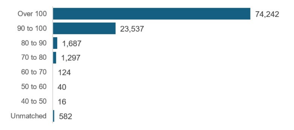
The method assigned a candidate road link to around 99% of 2025 STATS19 collisions, with 582 collisions unmatched. Chart 1 shows the number of records by match status and confidence band.
A high confidence score means that the selected network link agrees well with the STATS19 fields used in scoring. It does not prove that the link is correct. Manual review was therefore used to estimate match quality within each confidence band.
Chart 1: 2025 STATS19 collisions by outcome of matching and confidence score assigned
Unmatched collisions remain valid STATS19 records unless separate validation establishes that they are out of scope. They retain their original coordinates and police-recorded road fields but receive no matched-link identifier or network-derived attributes as a result of the matching process.
5. Quality assessment – manual review
To assess the quality of the matched network links, a sample of collisions at each confidence level were reviewed, considering the collision point location, the road information, the matched link and any other potential links, together with any further details (such as collision description or further location description). In each case the quality of the match was assessed as either:
- Good - representing a correct match, either complete agreement or no obvious alternatives (such that, this link would be assigned based on all the information available)
- Fair - considered a plausible link, but with some element of doubt such as presence of an alternative link meaning it not possible to be confident that this is the ‘best’ link.
- Bad - likely to be an incorrect match, or, where a more plausible match appears to exist but was not assigned.
For unmatched cases, the matching process was considered to produce a ‘fair’ result if these appeared to be out of the scope of STATS19, for example within car parks, but were erroneously included in the dataset, but a ‘bad’ result where a match to a plausible link was missed.
5.1 Manual review examples
The following presents some illustrative examples of matches at the different confidence scores. Figure 1a shows an example of a match with a high confidence score (100), which on review was deemed a correct match.
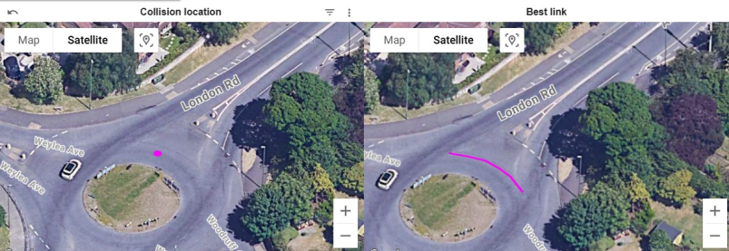
By contrast, Figure 1b shows a match with an equally high confidence score, but considered a ‘fair’ match. In this case, the collision description mentioned a pedestrian on the pavement near the roundabout being hit by a vehicle mounting the pavement. While the matched link corresponds well with the collision co-ordinates, this may not be precisely where the collision occurred in reality, but it is hard to be definitive from the information available.
Figure 1a : Example of a match with high confidence, considered as good
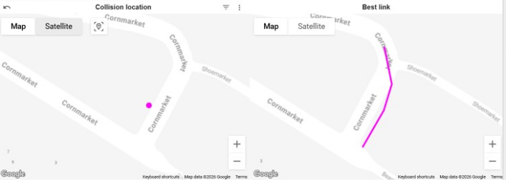
Figure 1b: Example of a match with high confidence, considered as fair
Figures 2a and 2b show examples of collisions that were not matched. The first case is considered ‘fair’, as it appears that the collision occurred away from the public highway (and thus should not have been included in the final STATS19 dataset). However, in the second case it appears that there was a suitable link, which was missed by the matching method as the collision co-ordinates were more than 25m from the road.
Figure 2a : Example of an unmatched collision, considered as fair
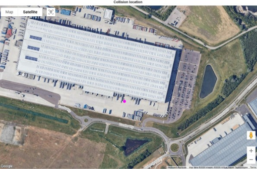
Figure 2b : Example of an unmatched collision, considered as a missed link (bad)
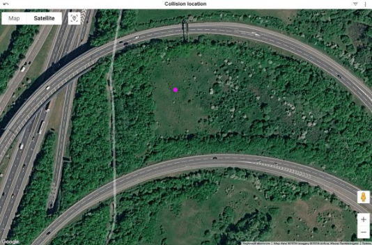
A more in-depth review was conducted for a small number (37) of unmatched collisions that appeared to plot on or near a road. Of these:
- 25 were on roads classified as restricted access within the OS data (and thus excluded from the network used for matching)
- 10 appeared to be wrongly identified as out of scope due to potentially erroneous OS data (such as a road being listed as restricted access when it appeared not to be) or network version issues (3 collisions on newly constructed roads)
- 2 appeared to be cases where the reporting police officer believed a private road to be public
This highlights some of the inherent issues in any automated network matching process. For this study, the matching was run on a dataset that had already been finalised. In future years, it is proposed to run the matching before the final validation is completed, so that any issues can be explored further including with reporting police forces where necessary.
5.2 Manual review summary
The above examples illustrate the challenges of matching collisions to a road network in some cases. However, overall the quality of the match was assessed as good. Table 1 summarises the results of manual review.
Match quality generally increased with the confidence score. Half of the matches scoring from 40 up to 70 were assessed as good, compared with 75% of those scoring from 70 up to 100 and 93% of those scoring 100 or over. All matches scoring 100 or over were assessed as either good or fair. After weighting for the number of collisions in each confidence band, around 90% of assigned links were assessed as good and 99% as good or fair.
The number of links with a confidence score below 70 is such that, for future versions of the matching, all matches with these scores would be manually inspected and improved where possible (including by seeking corrections from the police force data providers).
Table 1: Results of manual review by confidence score
| Confidence score | Number reviewed | Good | Good or fair |
|---|---|---|---|
| 40 up to 70 | 52 | 50% | 71% |
| 70 up to 100 | 170 | 75% | 95% |
| 100 and over | 81 | 93% | 100% |
| Overall estimate | N/A | 90% | 99% |
5.3 Considerations and limitations
The feasibility work has identified several areas where network matching appears promising, and several areas where users should expect caveats. Overall, the quality of the match generated appears sufficient as a basis for further development, with the majority of collisions matched with a high confidence score, and the majority of such cases likely to be correct.
However, the manual review revealed a number of edge cases and issues to bear in mind, which include:
- collisions which appear to be outside the scope of STATS19 (such as in car parks), which have been missed during annual validation
- collisions which fall on roads where it is hard to tell whether they fall within scope of STATS19 (such as restricted access, or private roads)
- potentially inaccurate information within the OS network, either due to gaps, or use of a version of the network that was not up to date at the time of the collision (and where e.g. a new road had been built)
- potentially inaccurate or outdated information within police systems, for example where road numbers have changed but the old numbers are being recorded (this appears to be a particular issue for collisions in London)
- cases where the collision co-ordinates are insufficiently accurate to confidently assign a network link, particularly where the road network is complex such as at multi-lane junctions or where there are several short links together in an urban area
- road class or number recording errors in the police recorded fields can prevent a match, even when the location itself may be plausible
Some uncertainty cannot be removed automatically, and the lower confidence cases are likely to require manual review, while residual error in higher-confidence matches can be described in the accompanying metadata. Given this uncertainty, it would be proposed that:
- where a match has a confidence score of under 75, it should be manually reviewed, and amended if necessary (such cases account for around 1% of collisions, but around 20% of estimated bad matches)
- Confidence score should be used to filter analyses where necessary, for example restricting to only the highest scores decreases the chance that a bad link is made.
6. Illustrative application of results
These results illustrate possible uses of the assigned road link. They do not change the collision coordinates and do not establish that OS values are more accurate than police-recorded values. Their purpose is to illustrate potential applications of STATS19 data matched to a road network.
The examples cover comparison of road class and indicative speed limit (an example of where network information might provide a basis to check the quality of police information), and a provisional example using pavement information (an example of a variable recorded in the OS data which is not routinely captured in STATS19).
6.1 Consistency of police-recorded and OS data
Assigning collisions to road links allows police-recorded and OS values to be compared where equivalent attributes exist. Agreement is a validation indicator only; it does not by itself show which source is correct, and it is partly influenced by variables used in the matching score.
Road class
Road class is recorded in both STATS19 and in OS data. Table 2 shows a comparison. Overall there is a strong degree of agreement (when considering C and U roads as equivalent, as is done within published statistics) – although the use of road class in the matching method may influence these results to an extent.
However, there are some roads which are coded as A or B in STATS19 which match to unclassified roads, or vice-versa. These are cases where use of OS information during STATS19 validation could potentially improve the quality of STATS19 recording, at the margins.
Table 2: Agreement between police-recorded and OS road class, Great Britain, 2025
| Police road class | Collisions | Agreement with matched OS road class |
|---|---|---|
| Motorway | 3,245 | 98% |
| A road | 43,666 | 97% |
| B road | 12,940 | 97% |
| C road | 4,544 | 97% |
| Unclassified road | 36,543 | 96% |
| Overall | 100,943 | 97% |
Speed limit
For example, Table 3 compares the speed limit values recorded in STATS19 with the indicative speed limit in the OS data, for those links. The OS data is derived from the OS NGD Speed dataset.
Overall, around 80% of values agree, with better agreement for higher speed roads, especially 70mph. Agreement is 87% for fatal collisions and 83% where police attended, compared with 73% for self-reported collisions. These differences may reflect STATS19 recording, match quality or both, so they should not be interpreted as evidence of cause without further analysis. Most disagreements are between adjacent speed limits (for example, 20 and 30 mph)
Table 3: Agreement between police-recorded and OS indicative speed limit for highest-confidence matches, Great Britain, 2025
| Police-recorded speed limit (mph) | Collisions | Agreement with OS speed limit |
|---|---|---|
| 20 | 12,650 | 76% |
| 30 | 36,872 | 81% |
| 40 | 6,737 | 68% |
| 50 | 3,804 | 69% |
| 60 | 9,434 | 82% |
| 70 | 4,673 | 93% |
| Overall | 74,170 | 79% |
6.2 Potential additional road attributes
As well as scope to improve the consistency of information recorded by the police in STATS19, matching may provide additional road attributes for analysis. Below is a very simple illustrative example. Further work would be dependent on engagement with OS around what could be made available.
Presence of pavement
An example of a variable available within the OS network but not routinely recorded in STATS19 is presence of pavement. Table 4 shows that the majority of collisions involving pedestrians occur on roads with a pavement present.
Table 4: Pedestrian collisions by presence of pavement, Great Britain, 2025
| Presence of pavement | Pedestrian collisions | Share of pedestrian collisions |
|---|---|---|
| None | 515 | 4% |
| Some | 513 | 4% |
| All | 12,457 | 92% |
| Total | 13,485 | 100% |
Further variables
Further variables which may provide a basis for further analysis, subject to the agreement of OS, include:
- average and minimum road width
- elevation gain
- presence of bus or cycle lane
- average speed, for different times of day
- road name (such as ‘High Street’) which may enable easier querying of the data for particular streets
6.3 Linking to other data
A further potential benefit is linkage through an OS road-link identifier. The identifier would be retained internally (unless OS confirms that record-level release is permitted, under appropriate end-user licence arrangements). Possible applications include:
-
traffic by road link, or route, to enable calculation of casualty counts or rates for particular stretches of the road network (for example, between particular motorway junctions). This may require further work to align networks with what is used for other road statistics, which remains an ongoing as the DfT roads geography team develops this over the coming years
-
enhanced road classification information for rural roads, when work to develop this has been completed. Currently the Department is working with the RAC Foundation to develop a classification of roads in rural areas, building on the feasibility study. The matched network could enable this classification to be assigned to STATS19 collisions, to provide estimates of how many collisions occur on different types of rural road.
6.4 Defining the scope of STATS19
In the longer term, one of the most significant benefits of road network matching may be the opportunity to move towards a more network-based definition of the roads that fall within the scope of STATS19. Current inclusion relies substantially on judgement by reporting officers and subsequent validation checks, which can result in uncertainty or inconsistency for some locations.
Matching collisions to a maintained national road network creates the potential to apply more objective and repeatable criteria based on network characteristics, classifications and accessibility. While further work would be required before such an approach could be adopted, it could provide a more consistent basis for determining the scope of the road casualty statistics across Great Britain.
7. Conclusion and next steps
7.1 Conclusion
The feasibility study demonstrates that most 2025 STATS19 collision points can be assigned to a plausible Ordnance Survey road link without altering the recorded coordinates. The method is suitable for further development, but is not yet a basis for replacing police-recorded fields or publishing OS-derived data, even in aggregate form.
The next steps are therefore operational rather than purely technical, including to agree the network product and annual version, finalise the quality threshold and review process, and confirm with OS which proposed identifiers, attributes and aggregate outputs may be released within DfT statistics (if any). While this remains a feasibility study, it is hoped to incorporate it into future production processes for road safety statistics.
7.2 Summer 2026: Incorporation into publication processes
Subject to stakeholder feedback and resolution of the network, licensing and production questions, the Department intends to develop the method for possible use in producing the 2026 road casualty statistics, scheduled for publication in summer 2027.
The main areas of development include:
- ongoing validation of the STATS19 collision location throughout the year. Coordinate quality remains fundamental because all subsequent matching decisions start from the recorded point location.
- exploring the potential tweaks to the matching method, for example as outlined below.
- systematic manual review of cases where the confidence score is relatively low, so that these are resolved before the annual data are finalised
The matching method could be further developed, considering some or all of the following:
- incorporating further information like vehicle directions
- using a probabilistic approach which would account for some degree of error in recording of some variables
- widening the current 25m radius outside which links are excluded from further consideration
- further consideration of what constitutes a STATS19 relevant road link within the OS dataset
7.3 Summer 2026: Enrichment of published statistics
If the method is adopted, the initial proposed published uses are aggregate statistics based on an improved rural-road classification and clearly labelled validation comparisons.
While the Department will explore what, if anything, could be provided at record level (via STATS19 open or sensitive datasets), it is likely that the nature of the OS data used will prevent such sharing, so that published outputs will be restricted to aggregate level at this stage.
7.4 Longer term plans
The proposed network update frequency is annual, aligned with final STATS19 production, and with advice and support from the DfT geography team in determining the most appropriate network and timescale for updating.
If this can be achieved, then it may be possible to consider whether network-based criteria for whether collisions should be included in STATS19 could be applied; this could remove some of the current uncertainty as to which roads are in scope and which are not.
8. Instructions for printing and saving
Depending on which browser you use and the type of device you use (such as a mobile or laptop) these instructions may vary.
Tablets and mobile devices normally have the option to “find in text” and “print or save” in their sharing or quick options menu of their browser, but this will vary by device model.
9. How to search
Select Ctrl and F on a Windows laptop or Command and F on a Mac
This will open a search box in the top right-hand corner of the page. Type the word you are looking for in the search bar and press enter.
Your browser will highlight the word, usually in yellow, wherever it appears on the page. Press enter to move to the next place it appears.
10. Contact details
Road safety statistics
Email roadacc.stats@dft.gov.uk
To hear more about DfT statistical publications as they are released, follow us on X (formerly known as Twitter) at DfTstats.