North Devon abstraction licensing strategy
Updated 28 January 2025

© Crown copyright 2025
This publication is licensed under the terms of the Open Government Licence v3.0 except where otherwise stated. To view this licence, visit nationalarchives.gov.uk/doc/open-government-licence/version/3 or write to the Information Policy Team, The National Archives, Kew, London TW9 4DU, or email: psi@nationalarchives.gov.uk.
Where we have identified any third party copyright information you will need to obtain permission from the copyright holders concerned.
This publication is available at https://www.gov.uk/government/publications/north-devon-abstraction-licensing-strategy/north-devon-abstraction-licensing-strategy
1. About the licensing strategy
This strategy sets out how we manage new and existing abstraction and impoundments within the North Devon area in the South West river basin district.
Our approach ensures that we:
- meet river basin management plan objectives for water resources activities
- avoid deterioration within this area
We apply this approach to the water body in which the abstraction is located.
It also applies to:
- all downstream surface water bodies that may be affected by any reduction in abstraction-related flow
- adjacent groundwater bodies affected by any reduction in groundwater level
Our guidance on managing water abstraction gives the technical explanation, legal and policy requirements behind the abstraction licensing strategy (ALS).
Please see our guidance if you need to:
- check if you need a licence to abstract water
- check if you need a licence to impound water
- apply for an abstraction or impounding licence
While our assessment tools are continuously updated, we aim to update this document every 3 years. Because of this some details in this document, for example hands off flow (HoF) values, may be out of date. You can contact the Environment Agency for the latest data.
1.1 Collaborative and sustainable water management
Our long term goal is to develop a stronger catchment focus for water resources. We are working with abstractors and catchment groups to:
- develop local solutions to existing pressures
- prepare for the future
Catchment groups may include a variety of different partnership groups such as:
- abstractor groups
- local catchment partnerships
- priority catchment groups
- environmental groups
In priority catchments across England we have explored:
- modern and innovative ways of improving access to water
- alternative ways to achieving sustainable abstraction
This strategy is a tool to make informed decisions on the choices abstractors make about their use of water. We want this strategy to help abstractors plan their water use and become more resilient in the face of climate change.
2. Area overview
The North Devon area covers approximately 2,362km2 in south west England (Map 1). It is divided into 2 catchments:
- Taw and North Devon streams
- Torridge and Hartland streams
Map 1: overview of the North Devon area
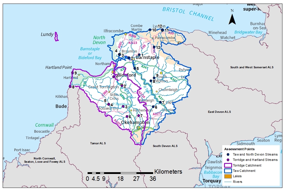
© Environment Agency
The landscape is dominated by agricultural land, interspersed with small villages and some urban areas.
Number of farms: 3,111.
Farmed area: 1944.95km2.
North Devon is a UNESCO World Biosphere Reserve and was the first of only seven to be designated in the UK. The aim of these sites is to improve the relationship between people and their local environment.
2.1 Landscape and land use
The Taw and North Devon streams contain an area of approximately 1437km2 that stretches from the headwaters of the River Taw on Dartmoor to the north coast at Lynton. The area is largely rural and contains parts of the Dartmoor and Exmoor National Parks as well as a section of the North Devon Area of Natural Outstanding Beauty (AONB). Agriculture is the primary industry while tourism and recreation are important, particularly in coastal areas.
Urban areas include:
- Barnstaple
- Braunton
- Illfracombe
- Lynton
- South Molton
- North Tawton
The catchment of the Taw lies between the granite of Dartmoor and the sandstones of Exmoor. Much of the catchment is underlain by hard fissured rocks of the Devonian and Carboniferous ages with outcrops of igneous permo-carboniferous rocks. Geology of this sort are characteristically of low porosity and permeability and groundwater flow is mainly associated with fractures and fissures in the rock body.
The Torridge and Hartland streams contain an area of 925km2 stretching from the north of Dartmoor to the north coast of Devon. This catchment includes the River Torridge with its tributaries, the coastal streams to Hartland and Lundy Island which lies 18km off the North Devon coast. The area is largely rural but urban areas include:
- Bideford
- Great Torrington
- Okehampton
The upper reaches of the River Torridge and the River Waldon contain many of the Culm Measures.
The geology of this catchment is dominated by deposits from the Carboniferous period. Permian deposits are present in the southeast of the catchment, forming the western extent of the Crediton Trough.
Table 1: land use type proportion of area (%)
| Land use | Proportion (%) |
|---|---|
| Permanent grassland | 59.79 |
| Arable | 16.70 |
| Forested | 16.36 |
| Urban | 4.05 |
| Other | 3.10 |
Land use statistics based upon LCM2019 © NERC (UKCEH) 2020.
Both catchments drain to the Taw-Torridge estuary.
More information on these catchments can be found on catchment data explorer and Magic map
2.2 Water resources
The River Taw is 72km long and drains to the Taw Estuary, as does the:
- Barnstaple Yeo
- Caen
- Bradiford Water
The Taw has several tributaries, the largest of which are the:
- Bray
- Mole
- Dalch
- Yeo
The catchment also contains the following, which flow to the north coast:
- Heddon
- East Lyn
- West Lyn
The River Torridge is 77km long and falls steeply down to the estuary at Bideford.
The catchment includes the following rivers:
- East and West Okement
- Lew
- Waldon
- Duntz
To the west of the catchment lies a small group of streams that include the:
- Welcombe Stream
- Abbey River
Under the requirements of The Water Environment (Water Framework Directive) England and Wales) Regulations 2017 (WFD Regulations 2017), a total of 92 river water bodies have been defined within the North Devon area. Water bodies are the surface water or groundwater units on which we carry out resource assessments.
In addition, there are 6 lake water bodies in the North Devon area:
- Wistlandpound
- Gammaton Lower
- Gammaton Upper
- Meldon
- Slade Higher
- Slade Lower
A total of 77 groundwater and surface water abstraction licences are currently authorised in the North Devon area (not including non-consumptive abstractions for hydroelectric power (HEP) generation).
This does not take into account the abstractions that do not require a licence. Activities that do not need an abstraction licence are listed in the guidance Check if you need a licence to abstract water.
The proportion of water abstracted by different sectors, based on total licensed quantities not including HEP generation, is summarised in Table 2.
Table 2: approximate proportion of water abstracted by sector
| Abstraction licence sector | Total licensed water quantity (cubic meters per year) | Proportion of total licensed water quantity (%) |
|---|---|---|
| Agriculture | 62,062,134 | 55.6 |
| Public water supply | 31,762,560.5 | 28.4 |
| Amenity and environmental | 16,261,828 | 14.5 |
| Industry and commercial | 1,435,423.5 | 1.3 |
| Crown and government | 80,091 | 0.1 |
| Energy generation (not including HEP) | 73,791 | 0.1 |
| Total | 111,675,828 | 100 |
South West Water is the principal public water supplier for the North Devon area. Wistlandpound reservoir is located on the edge of Exmoor National Park, it supplies drinking water to Combe Martin, Ilfracombe and Barnstaple. The 40-acre lake holds up to 1,550 megalitres when full. Northcombe Water Treatment Works supplies large areas of North Devon and is reliant on water from Roadford reservoir in the Tamar catchment. Meldon reservoir is situated on Dartmoor National Park and supplies drinking water to the Okehampton area.
An influx of summer visitors to the region changes the pattern of demand for the summer season. Water supply must be designed to cope with this seasonal demand.
2.3 Climate change
Climate change represents one of the greatest challenges for future sustainable management of water resources and will likely impact on the quantity and seasonal availability of water resources within the catchments.
2.4 Partnership working
There is a focus on developing collaborative approaches to water resources management and planning. We are seeking to engage with stakeholders to find solutions to water scarcity within these catchments. This brings together stakeholders from a range of interests to address issues in the catchments.
The North Devon Natural Solutions is a Devon Wildlife Trust project running from 2021 until 2027 that aims to deliver a step-change in land management over a 6-year period. Through working with landowners and communities, the project will deliver a series of small-scale practical interventions within detailed farm plans to improve the water quality, flood management potential, biodiversity and carbon sequestration capacity of North Devon’s landscape. More information can be found on this and other initiatives in the Nature Recovery Plan.
Catchment Based Approach (CaBA) is an initiative supported by a government policy framework aimed at delivering a more integrated and inclusive approach to managing the water environment at a catchment scale.
Woods for Devon is a programme of landowner engagement to encourage catchment based woodland creation and management improvements for water quality and water quantity improvements.
The Arlington Rewetting Project is a National Trust initiative that will deliver a range of interventions across Arlington estate that will rewet and restore habitat and improve the ecological status of the River Yeo.
3. Water resource availability in the North Devon area
The method for calculating the water resource availability is explained in managing water abstraction. Water availability is estimated at selected assessment points (APs). The maps show the water availability estimated at the AP; at a water body scale, water availability may differ.
There are 22 APs in the North Devon area.
13 are in the Taw catchment:
- AP 1: Collard Bridge – Lower River Yeo
- AP 2: Bradiford Water – Bradiford Water
- AP 3: Wrafton – Knowl Water
- AP 4: Velator Bridge – Lower Caen
- AP 5: New Bridge – River Taw
- AP 6: Taw Bridge – Upper Taw
- AP7: Lapford Yeo – River Yeo
- AP 8: Woodleigh – River Mole below confluence of River Bray
- AP 9: Mole Bridge – River Mole
- AP 10: Heddons Mouth – River Heddon
- AP 11: Riverside Road – West Lyn River
- AP 12: Lyndale Bridge – East Lyn River
- AP 13: Leehamford – River Bray
9 are in the Torridge catchment:
- AP 1: Mill Bridge – River Yeo below confluence of River Duntz
- AP 2: Torrington Gauging station – River Torridge
- AP 3: Rockhay Gauging station – River Torridge below Mussel Brook
- AP 4: Waltersmoor – River Torridge
- AP 5: Henscott – River Waldon
- AP 6: Gribbleford Gauging station – River Lew
- AP 7: Jacobstowe – River Okement
- AP 8: Welcombe Mouth – Welcombe Stream
- AP 9: Berry Cliff – Abbey River
In addition to availability, new surface water abstractions will be subject to the further considerations described in section 3.5.
3.1 Water resource availability colours and implications for licensing
We use colours to represent different surface water availability at a range of flows.
Water available for licensing
Green

There is more water than required to meet the needs of the environment. New licences can be considered depending on local and downstream impacts. Licences will be issued with a HoF restriction to protect environmental requirements at lower flows.
Restricted water available for licensing
Yellow

Full licensed flows fall below the environmental flow indicators (EFI).
If all licensed water is abstracted there will not be enough water left for the needs of the environment. No new consumptive licences would be granted. It is likely we’ll be taking action to reduce full licensed risks. Water may be available if you can ‘buy’ (known as licence trading) the entitlement to abstract water from an existing licence holder.
Water not available for licensing
Red

Recent actual flows are below the EFI (or have been overridden by a downstream AP where flows are below the EFI).
This scenario highlights water bodies where flows are below the indicative flow requirement to help support a healthy ecology in our rivers. We will not grant further licences in these water bodies.
We are currently taking action in these water bodies. Water may be available if you can buy (known as licence trading) the amount equivalent to recently abstracted from an existing licence holder.
Heavily modified water bodies (and discharge rich water bodies)
Grey

These water bodies have a modified flow that is influenced by reservoir compensation releases, or they have flows that are augmented. These are often known as ‘regulated rivers’. They may be managed through an operating agreement, often held by a water company. The availability of water is dependent on these operating agreements. There’s more detail in section 4.
There may be water available for abstraction in discharge rich catchments. You need to contact the Environment Agency to find out more.
The water resource availability is calculated, and the colour assigned, at 4 different flows:
- Q30 – the flow of a river which is exceeded on average for 30% of the time, therefore you would expect the river flow to be lower than Q30 on 256 days in an average year, that is, a higher flow
- Q50 – the flow of a river which is exceeded on average 50% of the time, therefore you would expect the river flow to be lower than Q50 on 183 days in an average year, that is, a moderate flow
- Q70 – the flow of a river which is exceeded on average for 70% of the time, therefore you would expect the river flow to be lower than Q70 on 110 days in an average year, that is, below moderate flow
- Q95 – the flow of a river which is exceeded on average for 95% of the time, therefore you would expect the river flow to be lower than Q95 on 18 days in an average year, that is, a low flow
3.2 Water availability maps
The water availability colours for the North Devon ALS are presented in Maps 2 to 5.
Tables 3 and 4 provide a summary of this information.
Map 2: water resource availability colours at Q30 for North Devon ALS
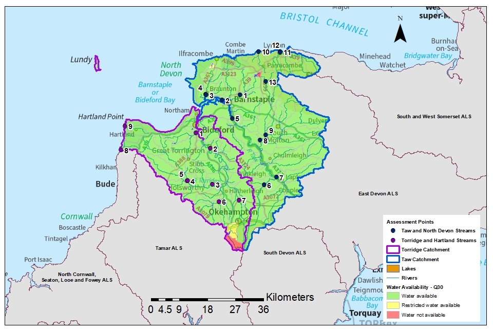
© Environment Agency
Map 3: water resource availability colours at Q50 for North Devon ALS

© Environment Agency
Map 4: water resource availability colours at Q70 for North Devon ALS
© Environment Agency
Map 5: water resource availability colours at Q95 for North Devon ALS
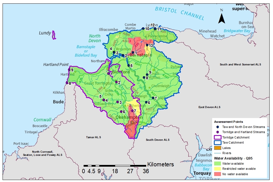
© Environment Agency
Table 3: summary of maps 2 to 5 – water availability at each AP by flow category in the Taw catchment
| AP and name | Q30 | Q50 | Q70 | Q95 |
|---|---|---|---|---|
| 1 Collard Bridge | Water available for licensing | Restricted water available for licensing | Restricted water available for licensing | No water available for licensing |
| 2 Bradiford Water | Water available for licensing | Water available for licensing | Water available for licensing | Water available for licensing |
| 3 Wrafton | Water available for licensing | Water available for licensing | Water available for licensing | Water available for licensing |
| 4 Velator Bridge | Water available for licensing | Water available for licensing | Water available for licensing | Water available for licensing |
| 5 New Bridge | Water available for licensing | Water available for licensing | Water available for licensing | Water available for licensing |
| 6 Taw Bridge | Water available for licensing | Water available for licensing | Water available for licensing | Water available for licensing |
| 7 Lapford Yeo | Water available for licensing | Water available for licensing | Water available for licensing | Water available for licensing |
| 8 Woodleigh | Water available for licensing | Water available for licensing | Water available for licensing | Water available for licensing |
| 9 Mole Bridge | Water available for licensing | Water available for licensing | Water available for licensing | Water available for licensing |
| 10 Heddons Mouth | Water available for licensing | Water available for licensing | Water available for licensing | Water available for licensing |
| 11 Riverside Road | Water available for licensing | Water available for licensing | Water available for licensing | Water available for licensing |
| 12 Lyndale Bridge | Water available for licensing | Water available for licensing | Water available for licensing | Water available for licensing |
| 13 Leehamford | Water available for licensing | Water available for licensing | No water available for licensing | No water available for licensing |
Table 4: summary of maps 2 to 5 – water availability at each AP by flow category in the Torridge catchment
| AP and name | Q30 | Q50 | Q70 | Q95 |
|---|---|---|---|---|
| 1 Mill Bridge | Water available for licensing | Water available for licensing | Water available for licensing | Water available for licensing |
| 2 Torrington Gauging Station | Water available for licensing | Water available for licensing | Water available for licensing | Water available for licensing |
| 3 Rockhay Gauging Station | Water available for licensing | Water available for licensing | Water available for licensing | Water available for licensing |
| 4 Waltersmoor | Water available for licensing | Water available for licensing | Water available for licensing | Water available for licensing |
| 5 Henscott | Water available for licensing | Water available for licensing | Water available for licensing | Water available for licensing |
| 6 Gribbleford Gauging Station | Water available for licensing | Water available for licensing | Water available for licensing | Water available for licensing |
| 7 Jacobstowe | Water available for licensing | Water available for licensing | No water available for licensing | No water available for licensing |
| 8 Welcombe Mouth | Water available for licensing | Water available for licensing | Water available for licensing | Water available for licensing |
| 9 Berry Cliff | Water available for licensing | Water available for licensing | Water available for licensing | Water available for licensing |
3.3 Groundwater resource availability
Water availability is the same for surface water and groundwater in the North Devon ALS.
Abstracting groundwater can impact on overlying surface water bodies. This impact is measured at the surface water AP. We cannot grant new groundwater licences where abstraction is reducing flows to below the indicative flow requirement to help support a healthy ecology. This is based on Q95 flows.
We must also account for:
- the impact of abstraction on protected sites
- the risk of saline intrusion
3.4 Resource reliability
If you want to apply for a licence, it’s worth considering the reliability of your abstraction.
By assessing the quantity of water available at different flows it’s possible to see:
- when there is a surplus or deficit of water
- the associated reliability of an abstraction
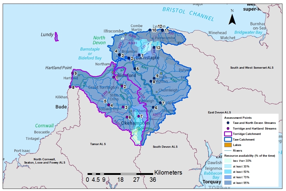
Map 6 gives an indication of the resource reliability for consumptive abstraction in the North Devon area expressed as a percentage of time.
In the Taw catchment:
- AP 2, 3, 4, 5, 6, 7, 8, 9, 10, 11, 12: water is available for consumptive abstraction at least 95% of the time (or 347 days per year)
- AP 1: water may only be available for consumptive abstraction 70% of the time (or 256 days per year)
- AP 13: water may only be available for consumptive abstraction 50% of the time (or 183 days per year)
In the Torridge catchment:
- AP 1, 2, 3, 4, 5, 6, 8, 9: water is available for consumptive abstraction at least 95% of the time (or 347 days per year)
- AP 7: water may only be available for consumptive abstraction 50% of the time (or 183 days per year)
This is an indication only. The actual reliability of a surface water licence will be discussed when you apply.
Map 6: water resource reliability of the North Devon area expressed as percentage of time available
© Environment Agency
3.5 Other considerations for resource availability and reliability
We will add constraints to licences such as HoF conditions to protect:
- the environment
- the rights of other abstractors
As a result, when we grant a licence, it doesn’t mean that we guarantee a supply of water. These conditions specify that if the flow in the river drops below what’s needed to protect the environment, abstraction must reduce or stop. In dry years, restrictions are likely to apply more often. This will affect the reliability of supply.
There is no guarantee that we will grant licences even where water is available for abstraction. This is because we must determine each application on its own merits. Local factors may mean we are either unable to grant a licence as applied for, or even at all.
New licences within the North Devon area will be time limited and issued with a common end date (CED), which allows them to be reviewed at the same time.
To ensure the initial CED will give a licence duration of between 6 and 18 years, if an application is made within 6 years of a CED, we will generally apply the subsequent CED to any licence granted. As the next CED for the Torridge and Hartland Streams catchment is scheduled for 31 March 2027, we will therefore apply the subsequent CED of 31 March 2039.
The next CED for the Taw and North Devon Streams catchment is 31 March 2030 and the subsequent one is 31 March 2042.
Short-term licences may be necessary where monitoring is required to reduce uncertainty regarding the impact of an abstraction.
Variations and renewals
Licence variations and the renewal of time-limited licences will be re-issued provided it can be shown:
- the abstraction is sustainable
- there is continued justification of need
- the water is used efficiently
If this is not the case, we may apply more restrictive conditions to the licence.
If your water abstraction licence needs to change, we will consider the impact of those changes on the environment and other abstractors before issuing a variation.
In catchments where water resources are not available or are restricted, we may seek to recover water through the licence renewal or variation process. There is guidance on renewing a time-limited licence on GOV.UK.
Non-consumptive abstractions
An abstraction is considered non-consumptive where the water removed is returned to the river at, or near, the point of abstraction without any significant loss. Whilst non-consumptive abstraction should have a neutral impact on water resources, we may apply restrictions to minimise effects on flow-depleted reaches. Additional restrictions may also be applied if a non-consumptive abstraction removes water from one catchment and discharges to another.
The most common type of non-consumptive surface water abstraction in the North Devon area is used for HEP. Use our contact details to obtain guidance on HEP applications.
3.6 Impoundments
Applications for impoundment licences will be dealt with on a case-by-case basis and take into account the requirements of our Habitats Directive obligations for designated sites and WFD Regulations 2017 obligations such as ensuring no likelihood of water body ecological deterioration.
An impoundment is a dam, weir or other construction in an inland waterway that obstructs or impedes flow or raises water levels. Our assessment of an impoundment application takes into consideration its potential impacts on the environment (such as fish migration), flood risk, downstream water users and flow modification. In line with current legislation, we do not time limit impoundment licences.
You must have an impoundment licence before you start to construct, alter, repair or remove an impoundment structure, even in an emergency. However, in certain circumstances licence exemptions apply and if we deem there is little or no impact on the environment and other water users, you may not need a licence. Please contact the Environment Agency if you intend to construct, alter, repair or remove an impoundment structure so that we may advise you whether a licence is required.
Use the Environment Agency’s guidance to check if you need a licence to impound water.
4. How we manage water availability in the North Devon area
4.1 Surface water
We assess surface water flows at APs, which are significant points on a river, often where 2 major rivers join or at a gauging station. APs cover multiple surface water bodies.
Water availability is the same for surface water and ground water in the North Devon area.
Tables 5 and 6 give an indication of:
- Whether there is water available for further abstraction
- the associated restrictions we may have to apply to new and varied abstraction licences from the main river
Depending on the nature of the catchment, tributaries to the main river may be subject to different restrictions and quantities. This will be assessed locally on a case-by-case basis.
Each HoF is linked to an AP and is dependent on the resource availability at that AP. In some cases, additional restrictions may apply to licences where there is a more critical AP resource availability downstream. This protects the ecological requirements of the river and other water users. This is detailed in the last column of Tables 5 and 6 if applicable.
All abstraction licence applications are subject to an assessment. This takes account of any local and downstream issues. It may be subject to further restrictions.
In cases where there is water available at all flows, we may apply a minimum residual flow (MRF) to protect very low flows. We will decide this on a case-by-case basis.
Table 5: Summary of licensing approach for the assessment points of the Taw catchment
| AP and name | Water resource availability | Is there a gauging station at this AP? | Additional restrictions |
|---|---|---|---|
| 1 Collard Bridge | Water may be available at moderate and high flows subject to local assessment. New licences could be considered. | Yes | Any new surface water abstraction will have to be assessed on a case-by-case basis |
| 2 Bradiford Water | Water may be available at all flows subject to local assessment. New licences could be considered. | No | Any new surface water abstraction will have a HoF that applies at a suitable gauging station or a local HoF will apply. |
| 3 Wrafton | Water may be available at all flows subject to local assessment. New licences could be considered. | No | Any new surface water abstraction will have a HoF that applies at a suitable gauging station or a local HoF will apply. |
| 4 Velator Bridge | Water may be available at all flows subject to local assessment. New licences could be considered. | No | Any new surface water abstraction will have a HoF that applies at a suitable gauging station or a local HoF will apply. |
| 5 New Bridge | Water may be available at all flows subject to local assessment. New licences could be considered. | No | Any new surface water abstraction will have a HoF that applies at a suitable gauging station or a local HoF will apply. |
| 6 Taw Bridge | Water may be available at all flows subject to local assessment. New licences could be considered. | Yes | Any new surface water abstraction will have a HoF that applies at Taw Bridge Gauging Station or a local HoF will apply. |
| 7 Lapford Yeo | Water may be available at all flows subject to local assessment. New licences could be considered. | No | Any new surface water abstraction will have a HoF that applies at a suitable gauging station or a local HoF will apply. |
| 8 Woodleigh | Water may be available at all flows subject to local assessment. New licences could be considered. | Yes | Any new surface water abstraction will have a HoF that applies at a suitable gauging station or a local HoF will apply. |
| 9 Mole Bridge | Water may be available at all flows subject to local assessment. New licences could be considered. | No | Any new surface water abstraction will have a HoF that applies at a suitable gauging station or a local HoF will apply. |
| 10 Heddons Mouth | Water may be available at all flows subject to local assessment. New licences could be considered. | No | Any new surface water abstraction will have a HoF that applies at a suitable gauging station or a local HoF will apply. |
| 11 Riverside Road | Water may be available at all flows subject to local assessment. New licences could be considered. | No | Any new surface water abstraction will have a HoF that applies at a suitable gauging station or a local HoF will apply. |
| 12 Lyndale Bridge | Water may be available at all flows subject to local assessment. New licences could be considered. | No | Any new surface water abstraction will have a HoF that applies at a suitable gauging station or a local HoF will apply. |
| 13 Leehamford | Water may be available at moderate and high flows subject to local assessment. New licences could be considered. | Yes | Any new surface water abstraction will have to be assessed on a case-by-case basis. |
Table 6: Summary of licensing approach for the assessment points of the Torridge catchment
| AP and name | Water resource availability | Is there a gauging station at this AP? | Additional restrictions |
|---|---|---|---|
| 1 Mill Bridge | Water may be available at all flows subject to local assessment. New licences could be considered. | No | Any new surface water abstraction will have a HoF that applies at a suitable gauging station or a local HoF will apply. |
| 2 Torrington gauging station (GS) | Water may be available at all flows subject to local assessment. New licences could be considered. | Yes | Any new surface water abstraction will have a HoF that applies at a suitable gauging station or a local HoF will apply. |
| 3 Rockhay GS | Water may be available at all flows subject to local assessment. New licences could be considered. | Yes | Any new surface water abstraction will have a HoF that applies at a suitable gauging station or a local HoF will apply. |
| 4 Watersmoor | Water may be available at all flows subject to local assessment. New licences could be considered. | No | Any new surface water abstraction will have a HoF that applies at a suitable gauging station or a local HoF will apply. |
| 5 Henscott | Water may be available at all flows subject to local assessment. New licences could be considered. | No | Any new surface water abstraction will have a HoF that applies at a suitable gauging station or a local HoF will apply. |
| 6 Gribbleford GS | Water may be available at all flows subject to local assessment. New licences could be considered. | Yes | Any new surface water abstraction will have a HoF that applies at a suitable gauging station or a local HoF will apply. |
| 7 Jacobstowe GS | Water may be available at moderate and high flows subject to local assessment. New licences could be considered. | Yes | Any new surface water abstraction will have to be assessed on a case-by-case basis. |
| 8 Welcombe Mouth | Water may be available at all flows subject to local assessment. New licences could be considered. | No | Any new surface water abstraction will have a HoF that applies at a suitable gauging station or a local HoF will apply. |
| 9 Berry Cliff | Water may be available at all flows subject to local assessment. New licences could be considered. | No | Any new surface water abstraction will have a HoF that applies at a suitable gauging station or a local HoF will apply. |
4.2 Historic licences
There are some historic licences that do not meet modern standards for the protection of flow and river ecology. These licences are not time limited and do not go through the renewal process.
For these licences of concern, we will work with the licence holder to negotiate changes to improve river flow. Where we are unable to progress voluntary licence changes, we may serve notice to enforce those changes.
4.3 Coasts and estuaries
WFD Regulations 2017 coastal water bodies within, or overlapping, the North Devon area include:
- North Cornwall
- Barnstaple Bay
- Lundy
- Bristol Channel Inner South
WFD Regulations 2017 transitional water body:
- Taw-Torridge Estuary
4.4 Heavily modified water bodies
These water bodies can be classified for many reasons, but for water resources they are classified if they may contain a lake or reservoir that influences the downstream flow regime of the river. The downstream ‘flow modified’ water bodies are also classified as heavily modified. They are designated for water resource purposes if the flow regime has been altered by flow regulation or augmentation.
In the North Devon area there are 6 heavily modified water bodies. These are:
- Meldon
- Gammaton Upper
- Gammaton Lower
- Slade Higher
- Slade Lower
- Wistlandpound
There are other water bodies in the North Devon area which have been designated as heavily modified water bodies for reasons other than water resources. These include flood protection, navigation, urbanisation and land drainage.
4.5 Protected sites
The Conservation of Habitats and Species Regulations 2017 (Habitats Regulations) provides a very high level of protection to 2 types of designated sites due to their special environment. These are:
- special areas of conservation (SAC), which contribute to biodiversity by maintaining and restoring habitats and species
- special protection area (SPA), which provides protection to birds and their nests, eggs and habitats
Several areas within the North Devon area are designated as SACs, SPAs and sites of special scientific interest (SSSIs) and additional restrictions may be applied to abstractions near or within these areas based on local assessment of impact on these sites. A list of these protected sites can be found under the ‘Land Based Designations’ on Magic map
Government policy treats Ramsar sites (internationally important wetland sites) in the same way as SACs and SPAs. Ramsars, SACs and SPAs are referred to collectively as European sites. SSSIs also carry a high level of environmental importance.
Conservation objectives are the main objectives for European and SSSI protected sites to maintain at, or to reach, favourable condition. These are set by Natural England. The process for setting targets is described through the Joint Nature Conservation Committee approved Common Standards Monitoring Guidance.
Natural England use these targets to assess the condition of European and SSSI protected sites. These quantitative targets are considered by Natural England as a pre-requisite for achieving the conservation objectives for European or SSSI designated sites. We have a duty to have regard to Natural England’s advice when determining licence applications that may impact on a designated site.
We may need more detailed supporting information when a licence application could impact on a designated conservation site. This will allow us to complete the required statutory assessment.
5. Managing these catchments together
5.1 Action on unsustainable abstraction
Our guidance on managing water abstraction gives details on:
- what an unsustainable abstraction is
- the measures available to resolve environmental issues caused by abstraction
WFD Regulations 2017 help us to focus on the ecological ‘health’ of our water environment. Its primary objectives are to prevent deterioration of ecological status or potential (for heavily modified water bodies), and where necessary, to restore ‘good ecological status/potential’ for surface water or ‘good status’ for groundwater. The flow regime is a supporting element to attaining good ecological status.
We will investigate where reduced water flow is contributing to environmental concerns attributed to licensed abstraction. Investigations into the impact caused by these licences may result in options being developed with licence holders on how to improve the sustainability of their abstraction. Options will include a cost and benefit analysis.
Revocation for non-use or reduction of underused licences
There is a large volume of water licensed within abstraction licences that has not been abstracted for a number of years. This limits water availability for those that need it. In some cases, it also represents a significant environmental risk if abstraction were to be restarted.
The Environment Agency has an unused licences programme which aims to reduce licensed abstraction which is not being used. This helps to reduce the risk of future deterioration and may release unused water for future licensing. Most changes to licensed quantities are made voluntarily. However, where there is risk of environmental damage, the Environment Agency can propose the revocation of unused licences. This is done using the legal powers under section 52 of the Water Resources Act 1991.
Water Industry National Environment Programme (WINEP)
Every 5 years, the Water Industry National Environment Programme (WINEP) sets out the requirements on water companies to address unsustainable abstraction. These are needed to meet the WFD Regulations 2017 and national targets.
The current WINEP period is April 2020 to March 2025.
South West Water are not undertaking any investigations or actions across their abstractions and reservoirs in the North Devon area for this current period.
Future investigations aim to:
- assess the impact abstractions are having on river flows and groundwater levels
- identify how the licences can be changed to restore flows to protect ecology
The details of the proposed investigations for South West Water in North Devon will be confirmed in December 2024 and completed in the next WINEP period (2025 to 2030). These include:
- Meldon Reservoir – investigation to assess if the continuous compensation flow to the River Okement downstream of the reservoir needs to be increased to provide higher baseline flows for ecology, especially fish
- River Bray – investigation to confirm if a future increase in abstraction within the headroom of the existing abstraction licence will cause flows below that required for good ecological status and, if so, to identify the licence change to prevent this occurring
- Upper River Yeo (Barnstaple) – investigation to confirm if a future increase in abstraction within the headroom of the existing abstraction licence will cause flows below that required for good ecological status and, if so, to identify the licence change to prevent this occurring
In the next WINEP period (2025 to 2030) the process to identify actions will become more collaborative with wider engagement to deliver multiple benefits for catchments.
Actions identified from the investigations, which may include changes to abstraction regimes and habitat improvements, will be delivered in the WINEP period from April 2030 to March 2035.
5.2 Approaches to sustainable water management
Five regional groups have been created in England to develop long-term water resources plans up to 2050 and beyond. The North Devon area falls in the West Country Water Resources Group. The area covered by this group includes Cornwall, Devon, South and West Somerset, Bristol Avon, Dorset, and Hampshire Avon.
It is a multi-sector group that includes representatives from:
- water companies
- National Farmers’ Union
- Drinking Water Inspectorate
- Consumer Council for Water
- Natural England
- Ofwat
- Canal and Rivers Trust
The regional groups have been tasked with considering the challenges and producing multi-sector regional plans. These will set out how water supply and demand will be managed over the long-term for people, businesses, and agriculture, whilst protecting the environment. They will need to understand environmental needs and develop the long-term environmental destination for water resources by:
- ensuring no deterioration
- addressing unsustainable abstraction
- improving environmental resilience in the face of climate change
The regional plans will set out the actions that water companies and other abstractors will need to take to reach the long-term environmental destination. Draft plans are published on the West Country Water Resources Group.
We have provided information to this group to help them identify catchments with existing or potential problems.
5.3 Water rights trading
We want to make it easier to trade water rights. A water rights trade is where a licence holder sells all or part of their water right, as defined by their abstraction licence, to another licence holder on a permanent or temporary basis. In the majority of cases a trade will involve a change in abstraction location or use which we will need to approve through the issue or variation of abstraction licences. Our approach to licensing water rights trades will depend on the water resource availability where the buyer and seller are located.
In licensing trades, as with new abstraction licences, we need to make sure that we do not impact SAC designated species and habitats nor cause any ecological deterioration in WFD Regulations 2017 water body status, either within the water bodies where the trade will take place or to downstream water bodies.
This section provides a guide to the potential for trading in water bodies of a particular ALS water resource availability colour, as shown on maps 2 to 5.
To find out more about licence trading, use our guidance on trading water abstraction rights.
Guide to potential trading based on water resource availability
Water available for licensing
Green
There may be opportunities to allow trades of recent actual abstraction and licensed abstraction. But little demand for trading expected within water body as water available for new abstractions.
Restricted water available for licensing
Yellow
There may be opportunities for licence holders to trade up to their full licensed quantities. But the quantities of water available to trade may be restricted once levels of actual abstraction reach sustainable limits. We will not permit licence trades in water bodies where we are taking action to prevent deterioration unless the trade is consistent with achieving water body objectives.
Water not available for licensing
Red
We will only trade recent actual abstraction but no increase in recent actual abstraction is permitted in water body. Licensed abstraction will be recovered for the environment.
Heavily modified water bodies
Grey
Opportunities for trading will depend on local operating agreements and local management.
Find out more about licence trading.
6. Glossary
Abstraction: Removal of water from a source of supply (surface or groundwater).
Abstraction licence: The authorisation granted by the Environment Agency to allow the removal of water.
Assessment point: A significant point on a river, often where 2 major rivers join or at a gauging station.
Catchment: The area from which precipitation and groundwater will collect and contribute to the flow of a specific river.
Catchment based approach: Partnership working at the river catchment scale to deliver a range of environmental, social and economic benefits while protecting our precious water environments for the benefit of all.
Consumptive abstraction: Abstraction where a significant proportion of the water is not returned to the source of supply after use. For example, for the use of spray irrigation, general agriculture, domestic use, public water supply and water bottling.
Deterioration: Deterioration is a change in the class of any one of the quality elements used to determine the WFD Regulations 2017 status in a water body from its existing class to the class below, or any deterioration within the lowest class. It is not a change within a class unless already in the lowest class.
Discharge: The release of substances (for example, water, treated sewage effluent) into surface waters.
Environmental flow indicator: Flow indicator to prevent environmental deterioration of rivers, set in line with new UK standards set by UKTAG.
Groundwater: Water that is contained in underground rocks.
Hands off flow: A condition attached to an abstraction licence which states that if flow (in the river) falls below the level specified on the licence, the abstractor will be required to reduce or stop the abstraction.
Impoundment: A structure that obstructs or impedes the flow of inland water, such as a dam, weir or other constructed works.
Non-consumptive: Non-consumptive water use is a use of water that does not cause a reduction in the source of supply and in which most, if not all of the water is returned without delay to the same source of supply.
Surface water: This is a general term used to describe all water features such as rivers, streams, springs, ponds and lakes.
Water body: Units of either surface water or groundwater which we use to assess water availability.
The Water Environment (Water Framework Directive) (England and Wales) Regulations 2017: Referred to as the WFD regulations 2017, to provide a framework for managing the water environment in England and Wales. These regulations revoke and replace the European Union Water Framework Directive.