
2. Plan your nature-based solutions for water resources project
Published 17 August 2026
Applies to England

© Crown copyright 2026
This publication is licensed under the terms of the Open Government Licence v3.0 except where otherwise stated. To view this licence, visit nationalarchives.gov.uk/doc/open-government-licence/version/3 or write to the Information Policy Team, The National Archives, Kew, London TW9 4DU, or email: psi@nationalarchives.gov.uk.
Where we have identified any third party copyright information you will need to obtain permission from the copyright holders concerned.
This publication is available at https://www.gov.uk/government/publications/nature-based-solutions-for-water-resources-handbook/2-plan-your-nature-based-solutions-for-water-resources-project
This guidance covers how to plan the implementation of nature-based solutions (NbS) for water resources in your catchment. Use it to help you:
- understand your site and catchment
- use conceptual modelling, catchment opportunity mapping and modelling of NbS impacts
- work with landowners and stakeholders
- consider other environmental objectives
- identify funding options
1. Before you start
Before you plan your project, check you understand how NbS for water resources work using our overview of NbS for water resources guidance.
Read Appendix 2: NbS for water resources literature review to understand what is already known about specific types of NbS for water resources interventions.
2. Planning NbS at landscape scale
You should take a strategic systems-based approach when planning to implement NbS at scale within catchments. Work with catchment partners, for example Local Nature Recovery Strategies (LNRS) responsible authorities and catchment partnerships, and use a holistic framework to plan the future state of the landscape.
NbS at the landscape scale centre natural processes to harness optimal environmental benefits. You can consider this systems approach as a counterpart to NbS.
You should draw upon the expertise of many different practitioners at various stages in the process, including valuable inputs from communities, landowners and regulators. Their contributions will be essential to the success of your project.
Understanding your landscape
Every landscape is unique, offering a different set of challenges, constraints and opportunities for NbS implementation. When designing NbS across a landscape, you need to have a thorough understanding of your landscape in its multiple aspects.
Although NbS can have benefits for multiple stakeholders in a landscape, other factors may vary within and between catchments, such as:
- ownership
- authority
- regulations
- stakeholders
- geology
- geography
- hydrology
- food production
A suite of NbS measures optimised for one catchment may not be suitable for another, even if they have superficial similarities. Unique combinations of NbS and implementation of tailored interventions are needed to realise NbS at the landscape scale and optimise the benefits for each landscape. This applies for water resources and other aspects of natural capital.
When evaluating the potential of NbS implementation in a catchment, you should consider the value of any existing good management practices and ecological processes. Any further NbS interventions should be designed to highlight the positive outcomes of these practices and sustain what already works well.
Choosing NbS measures for a landscape
When designing NbS across landscapes, you should prioritise using a wide suite of measures working together to provide water resources benefits. These measures should relate to different parts of the water cycle to:
- increase aquifer recharge
- increase groundwater resources
- boost low flows in rivers
For more information on the categories of NbS measures, see the Mainstreaming Nature-based Solutions’ common value framework (CVF) and NbS intervention categorisation.
You should carefully consider the locations of NbS measures within the catchment, using supporting data from mapping and modelling assessments.
You also need to understand the hydrogeological processes when deciding the location of NbS in a landscape. The impact of geology on the location of NbS measures is set out in section 3.
Walking the route that water might follow through a farm holding or a catchment will also allow you to identify potential locations for NbS features. For example, where hedgerows need to be modified or corner of field can be adapted to store water.
You can use a process understanding of individual NbS features to inform their designs and develop options for monitoring their effectiveness within the landscape. For example, monitoring stream flows can be carried out to assess the effectiveness of runoff attenuation features (RAFs) in boosting recharge.
Rigorous monitoring is important for demonstrating project successes and to inform programmes of maintenance. For more guidance on the monitoring and maintenance of NbS for water resources, see NbS for water resources: monitoring and maintenance.
Spatial scale of NbS
Although there must be a physical upper limit on increasing aquifer recharge, this is mostly unreachable for more practical implementation options. Increasing the scale on which NbS measures are implemented does not compromise their effectiveness. However, you should ensure that increased aquifer recharge does have undesirable impacts such as increased flood risk or mobilisation of pollution.
This was concluded by regional groundwater modelling studies mostly focused on catchments with existing pressures on groundwater resources. This contrasts with principles in Natural Flood Management (NFM), whereby the flood-mitigating effects of upland interventions can weaken with increasing catchment size.
Integrating NbS with wider environmental objectives
Implementation of NbS for water resources schemes will have multiple wider environmental benefits beyond enhancing water resources. Even if your scheme is funded and designed to provide water resources benefits, you should not focus on water resources alone. You should ensure that effort is made to maximise these positive externalities.
Other co-benefits of NbS apart from water resources are present for:
- water quality
- flood mitigation
- biodiversity
- air quality
- carbon sequestration
- food security
- soil health
- social value
NbS for water resources features can often be optimised to provide these co-benefits with minimal modifications and no negative impacts on water resources objectives.
You should identify these mutual relationships and exploit them when designing and constructing your suites of NbS to maximise natural capital gains.
Parts of your design that are optimal for water resources may not be optimal for providing other benefits and may result in disbenefits. You will need to manage these trade-offs and balance competing aims when planning a landscape.
Integrating NbS with water infrastructure
NbS measures may provide their many services at a less predictable rate than specially built infrastructure, and any system will have a limited capacity. For example, they may reduce the incidence of low flows during summer, but drought storage may be needed to maintain supplies during dry years and meet regulatory requirements.
To gain the full benefit of NbS for water resources, you may need to integrate them with infrastructure developments such as seasonal water storage or water delivery networks. For more information on integrating NbS with water infrastructure, see the Environment Agency’s position statement on NbS to support sustainable water resources.
Protecting and enhancing existing nature-based water services can:
- increase the efficiency of water infrastructure
- prolong the lifespan of existing infrastructure
- reduce the need for expensive infrastructural alternatives – needed due to degrading natural services
Integrating NbS into infrastructure planning and investment may:
- reduce costs
- provide new livelihood and recreation opportunities
- increase the sustainability of water management systems
- be more resilient to climate change by providing multiple mechanisms to achieve a joint aim
3. Understand your site and catchment
Gaining an understanding of your site and catchment ensures that your NbS can be implemented in the right locations to maximise their water resources benefits.
You should begin by undertaking desk-based assessments, including assessing the opportunities and constraints and reviewing LNRS and other existing opportunity maps.
Assess the opportunities and constraints
Your desk-based assessment should include opportunities and constraints across a range of disciplines.
Constraints should include, but not be limited to:
- risk of flooding and risk of drought
- ecological designations, presence or absence of specific species, assessment of non-native invasive species
- heritage assets which may constrain NbS
- presence of engineered infrastructure, public rights of way, utilities and services which may constrain construction
- presence of unexploded ordnance
- accessibility for construction machinery
- existing funding schemes may place constraints on what can and cannot be installed in a particular area
Opportunities should include, but not be limited to:
- policy drivers which support NbS implementation
- opportunity mapping to support or target specific forms of NbS
- funding opportunities which support NbS implementation
- presence of existing stakeholder and landowner networks within the catchment
Review existing opportunity mapping
You should start by reviewing existing open-source mapped data to give you an overview of the catchment.
The Environment Agency has produced maps of Working with Natural Processes (WWNP) potential across England. You can use this as a basis for NbS for water resources maps due to overlapping features. It includes an overview of the NbS which may be viable in a catchment including woodland planting, floodplain restoration and RAFs. More information on the Environment Agency’s WWNP mapping is in section 4.
Other open-source opportunity maps that you can review include:
- Forestry Commission’s England Woodland Creation Offer maps – a series of sensitivity maps to indicate the potential for, or sensitivities preventing, tree planting or woodland creation
- LNRS – locally led strategies that plan and target where action for nature recovery and environmental improvement should take place. There are 48 LNRSs that cover the whole of England and each one identifies the key environmental issues it will focus on, the actions to tackle those, and proposes locations that will have the greatest impact
- Natural England Multi-Agency Geographic Information for the Countryside (MAGIC) maps – helps you understand what habitats and designations are present in a catchment
- Wildfowl and Wetland Trust wetland creation potential maps – highlights areas across the UK that would benefit from wetland creation or restoration
- ALERT (Agricultural Land Environmental Risk and Opportunity Tool) – helps farmers and local advisors analyse the landscape and reduce agricultural pollution
- Regional NbS opportunity mapping from Water Resources East – identifies priority locations of different categories of NbS interventions
- Geological mapping from the British Geological Survey (BGS) – the online map portal and BGS Geology Viewer detail the superficial and solid geology to support development of conceptual understanding
- Water Resources Recharge Potential & Consultation Mapping - Overview - shows online mapping of where NbS solutions should be implemented and the associated risks
Using conceptual modelling
A hydrogeological conceptual model helps you understand how water moves through your catchment. It describes how a hydrogeological system behaves and how water enters an aquifer system, flows through and leaves.
You can use conceptual modelling to:
- predict and understand the behaviour of a groundwater system
- areas where surface water runoff should occur
- understand how the geology and superficial materials influence water flows in the catchment
- highlight the dominant controls on groundwater resources
- work out how changes in the catchment system may affect other parts of the water cycle
- refine the list of potential NbS benefits (or areas with limited benefits) to reduce wasted study effort
- visualise the catchment to help communicate processes to a wider audience
The features you should focus on to conceptualise NbS for water resources are:
- the pathways rainfall can be partitioned into
- the split between baseflow and quickflow
- the geological structure at different locations which may affect the water cycle and NbS implementation
Hydrogeological conceptual modelling can also be used to identify elements that could be affected by NbS, such as:
- topography
- infiltration patterns
- geology and hydrogeology
- streams and rivers
- surface water and groundwater interactions
For case studies of conceptual modelling for chalk and non-chalk catchments, see Appendix 1: NbS for water resources case studies.
The importance of geology and the water cycle
The splits in the water budget can differ widely between catchments.
When you develop your conceptual model, you should consider how the geology and parts of the water cycle vary between catchments and how this may change your approach to the implementation of NbS for water resources. You need to understand the hydrogeological processes when deciding where to place NbS in a landscape.
Geology influences catchment hydrology. For example, the proportion of river flow that comes from groundwater (known as baseflow index – BFI) is up to 98% in chalky upland streams but can be as low as 15% in low-permeability catchments. Geology, including superficial cover, determines whether NbS will be effective in providing the desired water resources benefits and the type of NbS measures best suited to doing so.
NbS measures are particularly sensitive to underlying geology and the aquifer system. For example, NbS measures which aim to modify the runoff-infiltration split of the substrate or to support runoff capture and infiltration are particularly sensitive to the permeability of the underlying geological deposits. Once water reaches more low-lying areas of the catchment, opportunities for it to be diverted into aquifers become more limited.
Although NbS measures which involve floodplain and river restoration can offer many benefits, these measures don’t generally improve the availability of water resources. This is due to issues such as increased evapotranspiration losses in the floodplain through raising water levels.
Where NbS are most effective
NbS for water resources have the greatest impact when focused on the shallow groundwater zones of the water cycle. For guidance on the 4 interventions in this zone and how these align with the aims of NbS for water resources, see Overview of NbS for water resources.
Table 1 presents the effectiveness of potential NbS measures across different aquifer systems. The effectiveness of measures is defined in terms of improvements to baseflows and recharge to aquifers.
The effectiveness is rated as follows:
- 3 is most effective
- 2 is effective
- 1 is possibly effective
- 0 is not suitable for this location
Table 1: Modelled relative effectiveness of NbS measures in different aquifer systems
You may need to scroll across to see the full table.
| Intervention type | NbS measures | Alluvial aquifers | High-permeability bedrock catchments | High-permeability bedrock catchments with patchy low-permeability superficial deposits | Moderate-permeability catchments |
|---|---|---|---|---|---|
| Water use | Low water use or evapotranspiration crops | 3 | 3 | 3 | 3 |
| Water use | Conifer plantation replacement | 3 | 3 | 3 | 3 |
| Runoff infiltration split | Soil improvement | 1 | 0 | 2 | 2 |
| Runoff capture and infiltration | RAFs | 1 | 0 | 2 | 1 |
| Runoff capture and infiltration | Boundary RAFs | 2 | 0 | 3 | 1 |
| Floodplain and river restoration | Wetland creation | 1 | 1 | 1 | 1 |
| Floodplain and river restoration | River restoration | 3 | 2 | 2 | 2 |
4. How to map NbS potential
Once you have developed your conceptual understanding of NbS potential, you can then map out the possibilities for NbS measures.
Mapping is important for strategic decision making for providing water resources benefits.
You can use catchment mapping to identify priority locations where NbS implementation may be possible and beneficial, including:
- selecting the most suitable types of NbS for the catchment and its geology
- estimating total land take of suites of NbS measures
- identifying suitable trial locations for NbS implementation
- relating NbS features to the geological properties of the subsurface
- parameterising NbS scenarios in groundwater models
- designing prioritised NbS schemes for water resources benefits and to achieve other environmental aims
- identifying potential risks and disbenefits associated with NbS implementation to be eliminated or mitigated
- visualising the possibilities for wider stakeholder and public consultation or engagement
You may use different mapping methods for spatial assessments of NbS, each suited to your specific needs and the nature of the proposed measures.
Mapping tools
Digital maps of NbS potential can be developed using a Geographical Information System (GIS) or computer programming language (for example Python). They have different strengths and weaknesses.
The developed maps can be viewed interactively within a GIS (such as QGIS or ArcGIS) or uploaded to an interactive web-based interface. You will need more specialist experience to generate maps using GIS than to view them.
GIS mapping techniques have:
- easy visualisation of intermediate outputs
- less complexity for the user
- more rigid functionality, albeit with a range of customisation options
- greater manual input required, so less suited to bulk processing
- somewhat self-contained software environment
Scripted mapping techniques have:
- more onerous visualisation of intermediate outputs
- more complexity for the user
- less rigid functionality and greater freedom to adapt methods
- more suited to bulk processing
- possible for interfacing with other software
Working with natural processes (WWNP) evidence base
You can use the Environment Agency’s national mapping of WWNP potential as a basis for NbS for water resources maps due to their overlapping features.
The layers of the Environment Agency’s WWNP evidence base, which were created using multiple datasets of land use, flooding, geology and hydrology, include:
- WWNP floodplain reconnection potential – low flood risk but close to a watercourse, the floodplain may be poorly connected with potential for reconnection to increase enhanced groundwater recharge
- WWNP floodplain woodland potential – fluvial flood risk with potential opportunities for floodplain reconnection, wetland development and planting at low density for enhanced groundwater recharge
- WWNP riparian woodland potential – within 50m of watercourses with the potential for river restoration and riparian planting for enhanced groundwater recharge
- WWNP RAFs – small areas of water storage which could support enhanced groundwater recharge like leaky dams, field corner storage and RAFs
- WWNP wider catchment woodland potential – slowly permeable soils with opportunities for improved land cover management and enhanced groundwater recharge
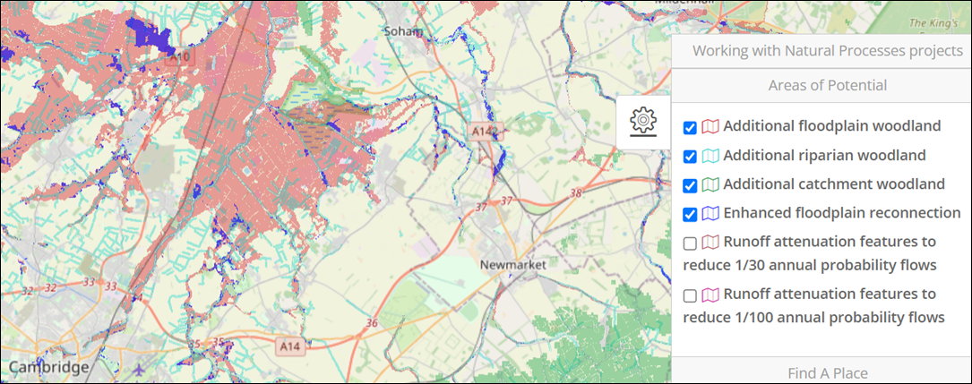
Figure 1 shows how you can visualise these layers using the map viewer developed by JBA Trust. You should use this dataset with a hydrogeological conceptual model (and potentially groundwater modelling) to test for effectiveness in improving water resources.
Figure 1: Example WWNP mapping from JBA Trust’s interactive online portal
Source: JBA Trust
For more information on mapping WWNP areas, see the WWNP mapping technical report and user guide.
Converting WWNP evidence base into NbS for water resources mapping
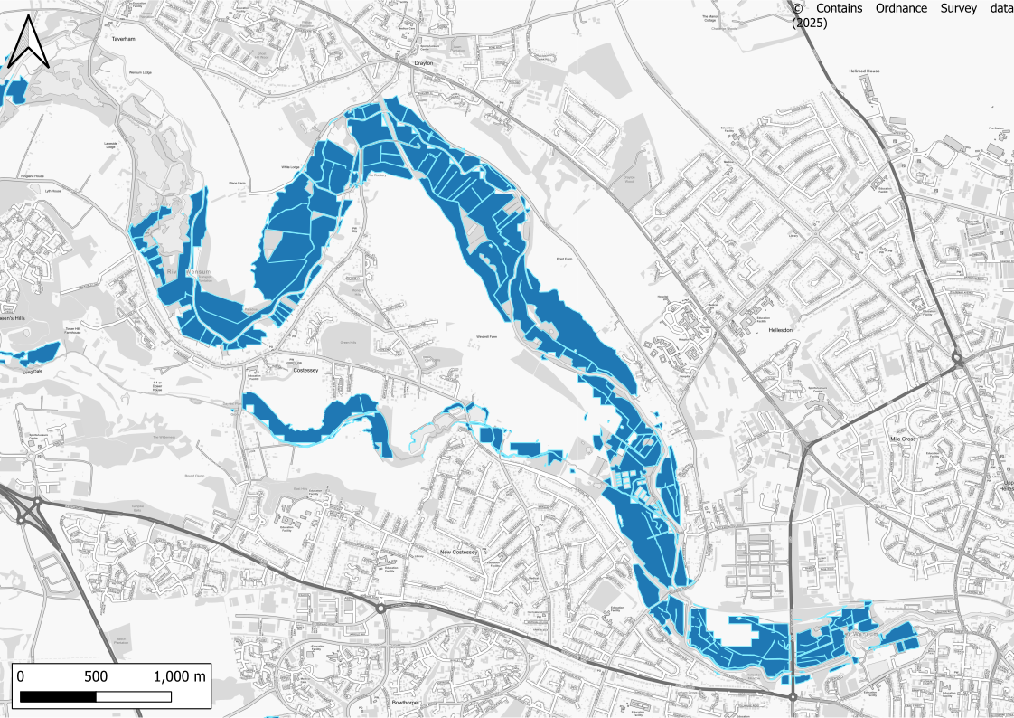
You can use the WWNP layers as a basis for more spatial processing when using mapping methods for identifying NbS for water resources potential. By combining datasets, you can describe catchment areas based on the types of NbS measures that may be beneficial. Figure 2 is an example output which shows opportunities in the lower catchment for floodplain reconnection.
You can use these methods to identify prioritised areas of NbS potential for interventions such as:
- stream, gully or ditch blocking, raising or reprofiling
- infiltration basins or hollows
- leaky dams
- bunds
- rewilding
- river restoration and renaturalisation
- floodplain reconnection
- riparian planting
- wetland development or enhancement
- soil improvements
- pasture and grazing management
- crop substitution, rotation and management
- shelterbelts or buffer strips
You can then define zones of the catchment with grouped NbS intervention types that could be successful.
Figure 2: Example NbS potential mapping showing areas with NbS potential for floodplain reconnection in the lower catchment
Once you have established where in the landscape NbS measures could be introduced, you will need to work out their potential for facilitating increased recharge to aquifers.
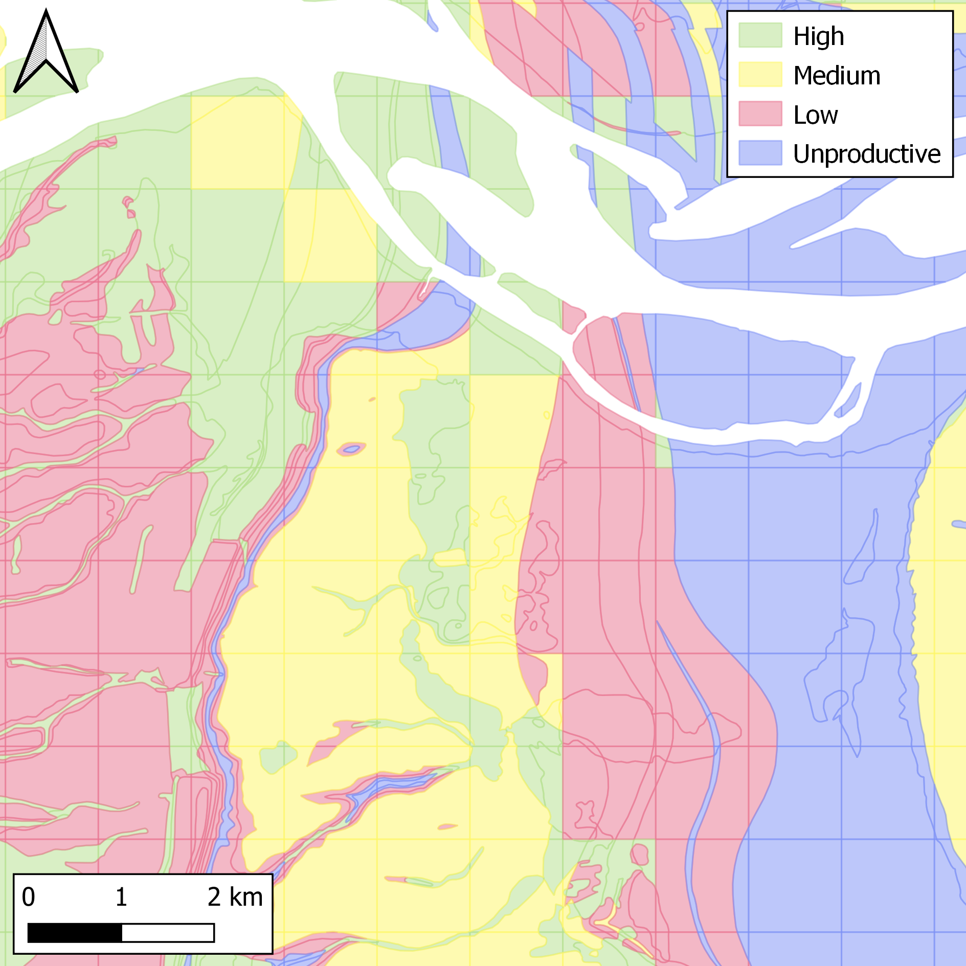
You can map recharge potential with a semi-quantitative approach using geological and hydrological datasets such as the Environment Agency’s Groundwater Vulnerability Map. Individual attributes are scored based on how much they contribute to modifying infiltration, with the scores then weighted and combined to give a combined scoring system for recharge potential. Categorised outputs for recharge potential are shown in Figure 3.
By joining NbS potential locations with recharge capacity potential, you can now prioritise areas for NbS that are:
- suitable for the implementation of measures
- likely to provide the most water resources benefits
Figure 3: Example of recharge potential mapping with categorised outputs derived from geological and hydrological data
Identifying unsuitable locations for NbS
You should also identify areas that are not viable for NbS implementation to avoid implementing ineffective NbS schemes.
Your opportunity mapping exercise may reveal that NbS implementation is not viable in an area due to:
- geological factors – for example extensive low-permeability material
- geographical factors – for example extensive urban land cover
Several existing maps are available from the Environment Agency and other organisations (for example Natural England). These identify areas of England with known environmental sensitivities or greater risks of geohazards and identify areas which may:
- be unsuitable for certain types of NbS
- need more investigative consultation to understand how to implement them safely and effectively
These datasets include:
- source protection zones (SPZs) for groundwater
- landfill sites
- areas of historic mining and pollution
- landslide risks
- groundwater dependent terrestrial ecosystems (GWDTEs)
- protected sites
You also need to understand existing pressures on water resources to target catchments for NbS interventions. The Environment Agency’s Water resource availability and reliability product classifies water environment (Water Framework Directive – WFD) catchments according to both:
- the availability of water resources within them
- the pressures imposed on them by abstractions
The Environment Agency has published national mapping of consultation areas tailored to NbS for water resources. This can be viewed within an interactive map alongside mapping of recharge potential.
For more mapping information see the MAGIC map.
Combining NbS opportunity maps with geological maps
If you are in a situation where opportunity mapping is not available, you can use geological maps. The geology of an area determines whether NbS will be effective in providing water resources benefits, as explained in section 1.
Geological mapping of Britain has been developed by the BGS and describes the uppermost superficial and bedrock types at a given location. You can use this alongside NbS opportunity mapping to help decision making.
You can easily overlay NbS opportunity maps with geological maps to understand the interactions between individual NbS features and underlying aquifers. This can be useful where NbS opportunity areas cross geological boundaries with a contrast in permeability. You can work out whether runoff from a low permeability area can be captured, pooled and diverted to groundwater by infiltration in the more permeable area.
You may wish to target areas with high groundwater vulnerability when planning NbS for water resources because they allow significant recharge. You can use the BGS Groundwater Vulnerability Map to represent the recharge properties of the substrate.
You can also use national soil mapping from Cranfield University as an alternative to groundwater vulnerability mapping. This classifies and describes the drainage of each type of soil from Freely Draining to Impeded Drainage.
Mapping limitations
Using broad-scale mapping for selecting individual sites for NbS implementation can lack precision. You should do more detailed mapping before starting work to identify constraints (spatial and locational) and shortlist areas for NbS implementation.
Two-dimensional maps are limited by the lack of variations in geology with depth, which determines recharge and shallow groundwater flow conditions. You can use geological cross sections alongside maps of NbS potential to improve your overall understanding of the system.
The accuracy of NbS maps is limited by the accuracy of data they are produced with. Public knowledge may be needed to identify exact locations for NbS implementation. You may need to do a site investigation, especially for features at the boundaries of different geologies. You can use mapping as a high-level tool to support landowner and stakeholder engagement and capture local knowledge.
5. How to work with landowners and stakeholders
To implement NbS successfully, you’ll need to build strong partnerships with landowners and stakeholders. Using opportunity maps is a good starting point to indicate where NbS could be most beneficial, but national datasets may not be locally accurate.
The Environment Agency supports the catchment-based approach (CaBA). You can search for your local catchment partnership using the CaBA website.
Speak to your local LNRS responsible authority about work happening in the catchment through their delivery partnership.
You should find out what organisations are already working in the same catchment area. This includes talking to non-governmental organisations (NGOs), public sector bodies and water companies to help you:
- understand the catchment better
- map out who is working where
- identify potential partnerships
- avoid duplication of effort
- access funding opportunities
- identify more detailed local datasets – to use alongside national opportunity maps to identify key locations for NbS implementation, for example local biological records
Identify landowners and managing expectations
It is important to engage with your landowners early on and use their local knowledge to help you shape your opportunity mapping into potential locations for interventions.
Once you have identified more specific locations for NbS implementation through local discussions, you should find landowners willing to allow NbS implementation on their land. Without willing landowners, such as land managers and farmers, NbS implementation will not be possible.
Third party intermediaries (such as NGOs and land agents) with established relationships with landowners can help you identify and engage landowners who may be willing for NbS implementation. If you already have good relationships with landowners, then you can continue this and provide in-house engagement.
You need to manage expectations with landowners. You should meet with them, share the objectives of the NbS project and describe the high-level findings from the initial desk-based assessment.
This phase of the project can take time and each case is different, for example:
- the landowner may wish to see outline designs before committing to proceed
- the landowner may need to get permission from their board to proceed
- the land manager or farmer may be interested in working with NbS implementation, but the landowner is not – this can prevent the project from proceeding
Catchment Sensitive Farming Advisors can provide free, confidential advice and training to help farmers produce food in a way that protects their local water, air and soil environments.
Conducting site visits
Site walkovers with landowners can capture their detailed local knowledge. You will need to:
- conduct multiple site visits over the course of the project
- agree with landowners when is convenient for visits
- potentially explain that if the site becomes known as an NbS showcase they may receive multiple future requests to host visitors
During a site visit, you’ll need to document on a map:
- how the site functions in high and low flows
- overland flow routes
- areas where water naturally forms ponds
- seasonal variations in site conditions
- historical flooding or drought impacts
You will also need to understand the landowner’s constraints and preferences by gathering information such as:
-
locations where landowners would or would not accept different types of NbS
- types of NbS which would or would not be acceptable to them
- operational constraints, such as livestock access and machinery requirements
- future land use plans that might affect project viability
You should conduct the site walkover with heritage, ecological, engineering, hydrogeological and geomorphological specialists. They will identify other opportunities and constraints related to NbS implementation, which you can use to develop those you already identified. For example, they may identify sites that must be ruled out as unsuitable.
Effective stakeholder engagement
Engaging stakeholders in NbS implementation for water resources benefits can be more complicated than engagement for flood purposes. This is because when NbS are developed for water resources purposes, they are restoring natural processes which are not always tangible, such as:
- infiltration
- evaporation
- restoration of low flows
- aquifer recharge
To engage effectively with stakeholders, you can develop physical models to help explain groundwater processes and show the effect of different NbS. For example:
- an ‘ant farm’ groundwater aquifer physical model to improve student learning of groundwater topics
- an animation by the Aquifer Partnership to explain how aquifers work
6. Undertaking surveys
You will need to carry out a series of surveys to help identify opportunities and constraints that inform the design process.
Surveys will include but not be limited to:
- ecology (including invasive non-native species)
- geomorphology
- geophysical and ground investigations
- heritage and archaeology
- landscape assessments
- reservoir inspections
- topography
- unexploded ordnance
- utilities
Depending on the project, you may also need to undertake additional baseline surveys to understand how the site evolves over time. For example, soil cores may be needed to establish how much carbon the site currently captures, creating a carbon baseline which can be revisited post-restoration to enable a comparison.
Your surveys will act as the foundation for developing the designs and will create a baseline for any long-term monitoring plans. You can also share them with the landowner to help develop good working relationships.
7. Selecting the NbS option
You can use the information collated during the desk-based assessment and site walkover to develop a longlist of all potential NbS options that may be feasible. Once a longlist is developed, you should appraise each of the options to:
- help define objectives
- examine options
- weigh up the costs, benefits, risks and uncertainties
The options appraisal process must be collaborative and undertaken in partnership with the landowner and other relevant stakeholders. An options appraisal meeting should allow all the different stakeholders to assess and vote for a preferred option.
The outcomes of the options appraisal will be the development of a preferred option, which will include either a single NbS measure or a suite of measures.
For guidance on designing and building the selected NbS option, see NbS for water resources: design and build your project.
The following sections will focus on how you can access funding options, model NbS impacts, plan NbS at a landscape scale and consider other environmental objectives.
8. Potential funding options
There are a range of potential funding sources for NbS implementation, including:
- government funding to support environmental outcomes
- research council and European funding to support research projects
- private sector funding to achieve environmental outcomes (for example net zero, biodiversity net gain (BNG) and nutrient neutrality)
- regulatory fines and water company funding sources
This section lists a summary of the potential NbS funding sources and other government commitments supporting the use of NbS.
Biodiversity Net Gain (BNG)
There is potential to fund NbS by offering up BNG units to developers and using the funds to support restoration.
Carbon and Net Zero
The Woodland Carbon Code and Peatland Code support the creation of carbon credits, based on the woodland planted or peatland restored. These credits can be sold as a way of generating revenue for a project.
Environment Land Management (ELM)
ELM schemes are the mechanisms for implementing the new land use framework in England. The schemes will pay land managers and farmers for providing environmental goods and services alongside food production. They include: Sustainable Farming Incentive, Countryside Stewardship, and Landscape Recovery.
European Funding
Since the UK left the EU, the only EU funding available to the UK is Horizon Research and Innovation funding which has a climate change focus. This could be a potential avenue for funding innovative ideas which require scientific study and data collection. This could be especially relevant to the more innovative NbS options (for example hybrid reefs).
Flood Defence Grant in Aid (FDGiA)
FDGiA is the main source of funding that the Environment Agency uses to fund compensatory habitat. The fund is quite constrained because it is required by all Environment Agency areas teams across England.
A NFM opportunity form is available from April 2026. This is for non-Risk Management Authorities (RMAs) submitting standalone NFM project opportunities up to £3 million to the flood and coastal erosion risk management (FCERM) investment programme. For more details and a list of standalone NFM interventions eligible for FCERM funding, see the Applying the 2025 FCERM funding policy: new project opportunity guidance.
Green Finance Brokerage
Green financing brokerage services are being developed for organisations looking to purchase nature credits or provide revenue to a project as a buyer of the outcomes (that is, flood risk reduction). There may be an opportunity to partner with them to offer NbS credits locally to help fund the implementation of NbS.
Nature Recovery Networks (NRN)
The NRN is a growing national network of wildlife-rich places, stretching from our cities to countryside, mountains to coast. The government is providing a range of funding streams, policies and delivery levers to support nature recovery, which LNRS will be able to help target.
Nutrient Neutrality
There is potential to fund NbS by offering up nutrient neutrality credits to developers in locations designated as nutrient neutrality areas.
Private buyers
Businesses who will benefit from the improvements your project provides may be interested in supporting the project, either through philanthropic giving, or as a ‘buyer’ of the environmental outcomes your project creates. For example, a business that purchases agricultural products may be interested in ‘buying’ soil aeration outcomes, as this improvement provides resilience in their agricultural supply chain.
Regulatory fines
Money from fines handed out to water companies will be re-invested in schemes that benefit the natural environment. The funding from these fines will be administered by NGOs in the implementation of NbS.
Species Recovery Programme
The Species Recovery Programme Capital Grant Scheme is funded and delivered by Natural England as part of its long-running Species Recovery Programme. It focuses resources on projects that address the needs of Priority, Threatened or Near Threatened species.
Species Survival Funds
The Species Survival Fund supports projects which ‘tackle habitat loss, safeguard our fragile ecosystems, and create and restore nature-rich landscapes’. It has been targeted to deliver against the government’s legally binding target to stop the decline in species abundance in England by 2030.
UK Research Institutes (UKRI)
UKRI may have science and research funding opportunities which could support future studies or long-term monitoring associated with NbS.
Water companies
Water companies have funding for environmental improvements which may offer opportunities for NbS implementation projects.
The Water Industry National Environment Programme (WINEP) is work that water companies in England are required to undertake to fulfil their environmental legislation and government policy obligations. It includes projects such as NbS which are funded and implemented to improve the environment to support legal drivers such as the WFD.
The Water Environment Improvement Fund (WEIF) encourages partnership delivery of projects to better connect and improve the status of priority water dependent habitats and species. The WEIF is administered by the Environment Agency and complements the development of NRN.
Other government commitments supporting the use of NbS
Green infrastructure framework
The Green Infrastructure Framework is a commitment in the Government’s 25 Year Environment Plan. It supports the greening of our towns and cities and connections with the surrounding landscape as part of the NRN.
Local Nature Recovery Strategies (LNRS)
LNRS in England are system of spatial strategies for nature recovery and wider environmental improvement introduced by the Environment Act 2021. Across England, 48 LNRSs have been produced setting out priorities and measures for creating or improving habitat to support nature recovery and deliver NbS.
LNRS responsible authorities will oversee the delivery of the LNRS for their area, including support for:
- the development of projects that deliver priority actions in the LNRS
- identifying funding opportunities
Delivering a NbS project that support delivery of an LNRS priority or measure may help get funding with some mechanisms incentivised to deliver LNRS, for example, biodiversity net gain.
Nature for Climate Fund
The £640 million Nature for Climate Fund was set up as part of government commitments to protect 30% of our land and sea by 2030. It aims to:
- create, restore and manage woodland and peatland
- triple afforestation rates across England
- restore 35,000 hectares of peatland
9. Modelling NbS impacts
Understanding the impacts of NbS is essential to any analyses of costs and benefits for your project. There are numerical and analytical modelling tools available that you can use to quantify likely changes to water resources from the implementation of NbS at a regional scale.
You can use modelling tools to help predict:
- the scale of NbS implementation needed to achieve desired water resources benefits
- the effectiveness of specific NbS measures in different geological and hydrological contexts
- the spatial distribution of impacts on the water cycle throughout a catchment
- the timescales on which water resources benefits are likely to be realised, along with the seasonality of the associated effects
Modelling tools
The Environment Agency and its partners have several regional models that simulate coupled recharge and groundwater flow within major aquifers across England. They simulate how different categories of NbS could offer water resources benefits to support decision making in the strategic management of groundwater resources.
These regional groundwater models are well established for evaluating the effects of NbS implementation on water resources due to:
- their extensive testing
- their extensive spatial coverage of key areas of England
- the range of results available from them
- the methodological robustness of their use
These models combine a surficial hydrological model (either 4R or SWAc codes) with an underlying groundwater flow model constructed in MODFLOW.
4R and SWAc codes
4R and SWAc are modelling tools developed specifically for regional water resources estimation in England. Both codes are similar in how they represent surficial hydrological processes.
4R is a proprietary software owned by WSP written in the Fortran programming language. It uses text-based and Surfer grid input files.
SWAc is open-source software developed by Groundwater Science written in the Python programming language. It uses text-based input files.
Spreadsheet recharge modelling
Spreadsheet modelling is a more rapid and simplified way to model and assess NbS implementation compared to running full regional simulations. You can use it to approximate a single model cell or lumped catchment and perform initial screenings of NbS options. You can then take forward selected options for testing using a full regional model.
‘Simple’ spreadsheet versions of 4R and SWAc have been developed for NbS modelling. Both emulate the processes in their full versions, but only for a single location at a time. Model parameters can be easily changed in the spreadsheet to simulate changes due to NbS implementation. This yields instant results which can:
- avoid the need to run a full simulation requiring hours of computational time
- allow parameter combinations to be bulk tested for initial screening assessments
- optimise parameter combinations for specific NbS interventions
- allow options to be discounted when they appear to offer limited water resources benefits
Simple spreadsheet modelling and regional modelling are often complementary, but you should consider the relative merits of each as set out in Table 1.
Table 1: Comparison of simple spreadsheet modelling and full regional simulation
| Simple spreadsheet | Full regional simulation |
|---|---|
| Rapid generation of results | Time-consuming computational exercise |
| Suitable for use by non-specialists | Requires specialist operation |
| Fast manipulation of model parameters | Parameterisation can be more complex |
| User-defined processes can be added | Coding of new processes requires specialist knowledge |
| Limited range of output formats | Wide-ranging outputs |
| Confined to a single location, with no spatial heterogeneity | Results available for an entire catchment |
| No simulation of groundwater and fluvial processes | Includes simulation of groundwater and river flows |
| Analytical model without stability issues | Potential stability issues with a numerical model |
| Limited usefulness of the results in relation to other impacts of NbS | Potential for the use of the results for the assessment of other effects of NbS in relation to water quality, flood risk etc. |
| Available to use without a licence | A data licence must be obtained in advance for use of the Environment Agency’s regional models |
| Ease of file management, the model being contained within a single Excel document | Large number of input and output files can be required, some of which can have large data storage requirements for big models |
| No inbuilt audit trail for model results | Inbuilt audit trail in the form of output log files written out during simulations |
| No automated parameter checks are built in | Basic automated model checks are built in |
| Ease of communication of results with a lay audience | Some aspects of the modelling processes may prove a little cryptic to a wider audience of non-specialists |
| Could be adapted to be hosted on a web portal | Not particularly suitable for web hosting |
Distributed recharge modelling
SWAc and 4R have the same framework for modelling runoff and recharge processes, based on the approach for computing crop water requirements (from the Food and Agriculture Organization – FAO). This calculates the daily movement of water through the landscape – including infiltration, surface runoff into rivers, and evapotranspiration back into the atmosphere – to produce detailed water balances.
This is to help you understand where water goes in different landscapes when designing NbS for water resources. It shows you the best places to put water management measures.
How distributed recharge modelling works
SWAc and 4R divide the landscape using a two-dimensional grid, across which they make calculations on a daily timestep.
They use a system of water ‘stores’ to represent components of the near-surface water cycle. Water moves between stores based on a user-defined set of parameters relating to real geological and hydrological properties across the study area.
For both SWAc and 4R, dedicated NbS modules have been developed as part of projects for the Environment Agency. This allows for RAFs and other related features to be represented within recharge models.
To do this, you can modify the code to enable the capture and subsequent release of runoff using basin-like stores across the landscape. You can vary the properties of these features across cells in the model, including:
- the dimensions of structures
- their infiltration capacities
- rates of leakage from them
Groundwater modelling using MODFLOW
While 4R or SWAc can be used in isolation to estimate recharge to aquifers, it’s often not enough for a full understanding of water resources benefits of NbS. You may need to combine a recharge simulation with a three-dimensional groundwater flow model. MODFLOW is used for this in the Environment Agency’s regional models.
MODFLOW is a freely available numerical modelling tool from the United States Geological Survey (USGS).
You can use MODFLOW to simulate:
- groundwater flows in the subsurface
- the exchange of water between aquifers and surface features (for example rivers)
In the Environment Agency’s regional models, an overlying 4R or SWAc recharge model is usually run independently. This generates boundary condition input files to be read by MODFLOW, including:
- simulated recharge to groundwater
- evapotranspiration demand from the water table
- flow within the stream network
The results from MODFLOW can help you estimate water resource benefits by working out flows in the river network and fluxes of water to and from aquifers.
You will need a post processing software to generate readable results as this is not possible with the raw output files. You can use a graphical user interface (GUI) to view MODFLOW models.
You can generate flow duration curves for strategic points on the river network by processing 4R or SWAc outputs along with those from MODFLOW. You can build water budget analyses (including estimates of occupied aquifer storage) using ‘Zonebudget’ from the USGS.
MODFLOW also has widespread uses beyond water resources estimation.
Structuring a modelling study
Your project may benefit from an NbS groundwater modelling study using a phased approach, from initial conceptualisation (see section 1) through to full regional modelling.
A recommended approach, which you can amend for your study, is as follows.
Conceptualisation phase – geological conceptual modelling of the catchment
You should start to develop an initial understanding of the hydrogeological processes in the study area. Think about what sorts of NbS measures might be possible and beneficial for water resources within the catchment, which will be limited by the geology and superficial deposits within. Build a knowledge base of where the implementation of NbS in the catchment may be beneficial.
Scoping phase – simple spreadsheet modelling for a longlist of options
You should use simple quantitative approaches to test selected NbS options in potential trial locations. Representative geological and hydrological properties can be used for this analysis. Simplified spreadsheet tools are available which you can use to estimate changes to infiltration for defined NbS options. Choose the more promising options for further testing using more advanced modelling tools.
Recharge modelling phase – hydrological modelling to simulate recharge to groundwater
You should run the full version of 4R or SWAc to quantify surface hydrological processes across the catchment for selected NbS options. Key processes being simulated will include:
- rainfall
- evapotranspiration
- runoff
- interflow
- infiltration
You can use modelling outputs to estimate distributed recharge to groundwater within the study area. More groundwater flow modelling can be done by producing boundary conditions for MODFLOW related to:
- recharge to groundwater
- evapotranspiration from the shallow water table
- flow in the stream network
Groundwater modelling phase – groundwater flow modelling to simulate regional water resources effects
You should use input files from the previous recharge modelling phase to carry out 3D groundwater flow modelling across the catchment using MODFLOW. You can use this to estimate aquifer storage and low flows in rivers over time, allowing you to quantify benefits to water resources.
You must postprocess outputs from MODFLOW to get readable results. You can then do further detailed analysis or tabulation of the results, and visualisation with maps and charts. You can then carry out economic appraisal of NbS options using various metrics.
Modelling case studies
NbS modelling has been implemented for the Environment Agency and partner organisations using several of their regional models, namely:
- Northern East Anglia Chalk (NEAC) model in the East of England
- Cam and Bedford Ouse (CBO) model in the East of England
- Test and Itchen (T&I) model in Hampshire
- Otter (OTR) model in Devon
The NEAC, CBO and T&I models are examples of Chalk-dominated catchments (each with different properties – see the evidence base for full details). The OTR model contains the Otter Sandstone aquifer that is part of the Sherwood Sandstone Group.
These models are built using 4R for recharge estimation (using SWAc for the OTR model) and MODFLOW for groundwater simulation. The NEAC, CBO and OTR models used MODFLOW 96, while the Test and Itchen model has been upgraded to use MODFLOW 6 on an unstructured grid.
Catchment themes
Alongside other NbS measures, the installation of RAFs has been tested extensively using the NEAC, CBO and OTR models. The use of ‘boundary RAFs’ has been effective in catchments with low-permeability geological deposits in upland areas that give way to highly permeable geologies in low-lying portions of the catchment.
These boundary RAFs can be constructed downstream of the interface between the two geology types. This potentially allows high volumes of upland runoff to be captured and diverted into the ground where the infiltration capacity is significantly higher.
In the NEAC and CBO models, boundary RAFs on areas of chalk immediately downstream of till deposits could provide sizeable water resources benefits for relatively minimal land take. However, this requires ground truthing with field trials, as areas of low-permeability weathered chalk may not be fully represented within models. In the OTR model, boundary RAFs downstream of mudstone bedrock were capable of significantly increasing recharge to the Otter Sandstone aquifer.
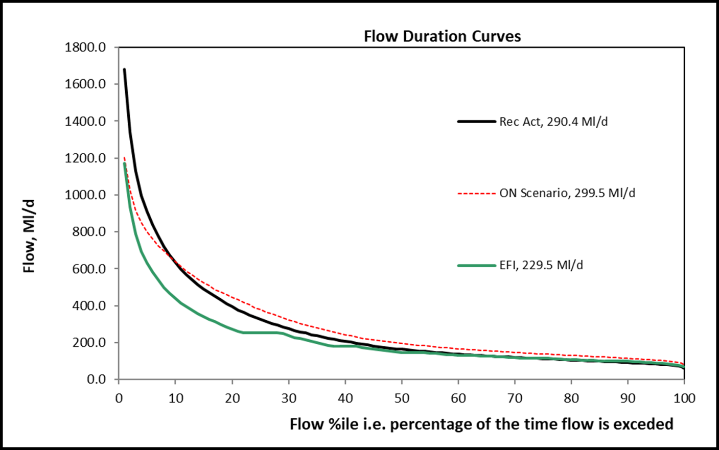
Figure 4 shows how groundwater levels in the OTR model for an average rainfall year could be raised for a combined NbS scenario involving RAFs and other measures. The effects of NbS measures on low flows in rivers can be assessed using flow duration curves, as shown in Figure 5.
In catchments with appreciable surface runoff, measures other than RAFs can be effective in promoting aquifer recharge through infiltration. Measures to improve soil health and structure can reduce rates of runoff and divert water to aquifers on suitable geologies. Soil improvements on areas of till in the NEAC and CBO models have been shown to be effective in boosting water resources.
Figure 4: Modelled increases in groundwater level within the Otter Sandstone aquifer in an average year due to a combined NbS scenario with full uptake of potential measures
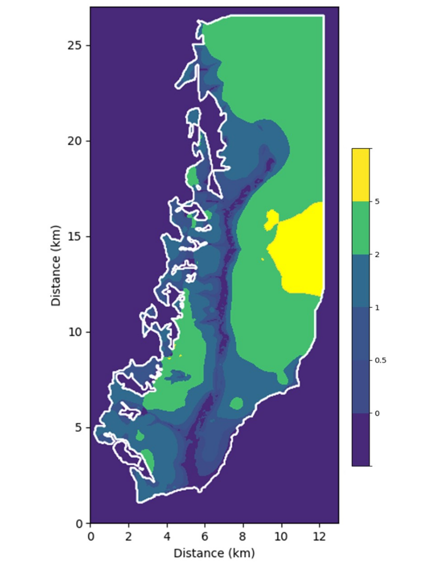
Figure 5: Flow duration curves for the River Otter for baseline (‘Rec Act’) and a combined NbS scenario (‘ON Scenario’) with full uptake of measures relative to the Environmental Flow Indicator (EFI)
For catchments such as the Test, mostly underlain by a highly permeable geology, NbS measures to capture or minimise runoff are of limited effectiveness. This is because rates of recharge to groundwater are high and there is little runoff available to be captured.
NbS measures that change land use and reduce associated water demands can potentially be substantially more effective in the Test catchments. These land use changes can offer benefits beyond water resources and have been shown with modelling to reduce diffuse pollution.
Secondary effects of NbS
The use of NbS modelling for assessing water resources benefits has identified other potential issues or opportunities that could arise through their implementation. Some of these effects can also be quantified through modelling.
The co-benefits of NbS for water resources measures are multiple and wide ranging (see section 2). You can build models to optimise the co-benefits associated with NbS for water resources, for example:
- enhancing water quality and reducing diffuse pollution loads within catchments
- increasing carbon storage
- leading to reductions in flood risk
Measures to enhance areas of wetland on the floodplain result in the elevation of the water table within riparian areas. This can potentially increase rates of evapotranspiration from the shallow water table and deplete aquifer storage over time.
Modifications to the runoff regime within a catchment will inevitably have impacts on the dynamics of erosion and sedimentation within it. For example, the installation of RAFs can increase the capture of fine-grained sediments, leading to localised accumulation of material. Conversely, soil improvement measures can lead to retention of sediment locally and slow the erosion of sediment from fields. Related to this, many NbS features, from RAFs to wetland restoration, can have positive effects on nutrient cycling and water quality.
The intended raising of groundwater levels associated with NbS for water resources brings water tables closer to ground surface in low-lying portions of the catchment. This can increase the risk of groundwater flooding and potentially put property and infrastructure at increased flood risk during extreme events.
Limitations of modelling
While the Environment Agency’s regional models are well-calibrated and can reproduce the behaviour of hydrogeological systems in detail, there are limitations to their applicability and accuracy.
Some of the modelling limitations include that:
- the models simplify reality and are limited by the availability of high-quality data with which they are parameterised and validated
- there are significant uncertainties surrounding the parameterisation of some processes such as evapotranspiration and canopy interception associated with trees – many NbS schemes may consider tree planting to support wider environmental benefits, but their representation in models may not always be ideal for predicting the effects on water resources
- certain processes are not currently fully represented within the models, for example spray irrigation is only represented approximately
- the models are typically built on a relatively coarse grid and with monthly stress periods, limiting the scale at which the outputs can be interrogated
- while modelling can provide an informative and quantitative overview of the regional water resources effects of NbS, impacts of individual NbS features can be more difficult to model accurately due to locally variable ground conditions
- field monitoring of NbS sites can verify or refute the predictions of models, and results can be used to refine the parameterisation of models – for guidance on monitoring, see NbS for water resources: monitoring and maintenance
For examples of other modelling approaches used to evaluate the effects of NbS implementation on water resources, see Appendix 2: NbS for water resources literature review.
10. Next steps
You can now proceed to developing the design for the NbS option you have selected. This will include either a single NbS measure or a suite of measures.
For guidance on designing and building your selected NbS option, see NbS for water resources: design and build your project.
11. Contact the Environment Agency
If you have questions about any aspects of this guidance, or would like to request copies of simple spreadsheet versions of 4R or SWAc, contact the Environment Agency.
General enquiries
National Customer Contact Centre
PO Box 544
Rotherham
S60 1BY
Email enquiries@environment-agency.gov.uk
Telephone 03708 506 506
Telephone from outside the UK (Monday to Friday, 8am to 6pm GMT) +44 (0) 114 282 5312
Monday to Friday, 8am to 6pm.