National Underground Asset Register project update October 2022
Published 6 October 2022
Applies to England, Northern Ireland and Wales

© Crown copyright 2022
This publication is licensed under the terms of the Open Government Licence v3.0 except where otherwise stated. To view this licence, visit nationalarchives.gov.uk/doc/open-government-licence/version/3 or write to the Information Policy Team, The National Archives, Kew, London TW9 4DU, or email: psi@nationalarchives.gov.uk.
Where we have identified any third party copyright information you will need to obtain permission from the copyright holders concerned.
This publication is available at https://www.gov.uk/government/publications/national-underground-asset-register-project-update-october-2022/national-underground-asset-register-project-update-october-2022
An overview of NUAR
A significant proportion of our utility, building and transport infrastructure is buried underground, including around 4 million kilometres of pipes, electricity and telecoms cables, and sewers[footnote 1]. It is estimated that a hole is dug every seven seconds to access these pipes and cables for repairs, upgrades and installations. This busy and usually unseen environment suffers from an estimated 60,000 accidental strikes per year, leading to injury, project delays, and disruption to traffic and local economies [footnote 2]. The total direct and indirect costs of these accidental strikes are estimated to be £2.4 billion a year[footnote 3].
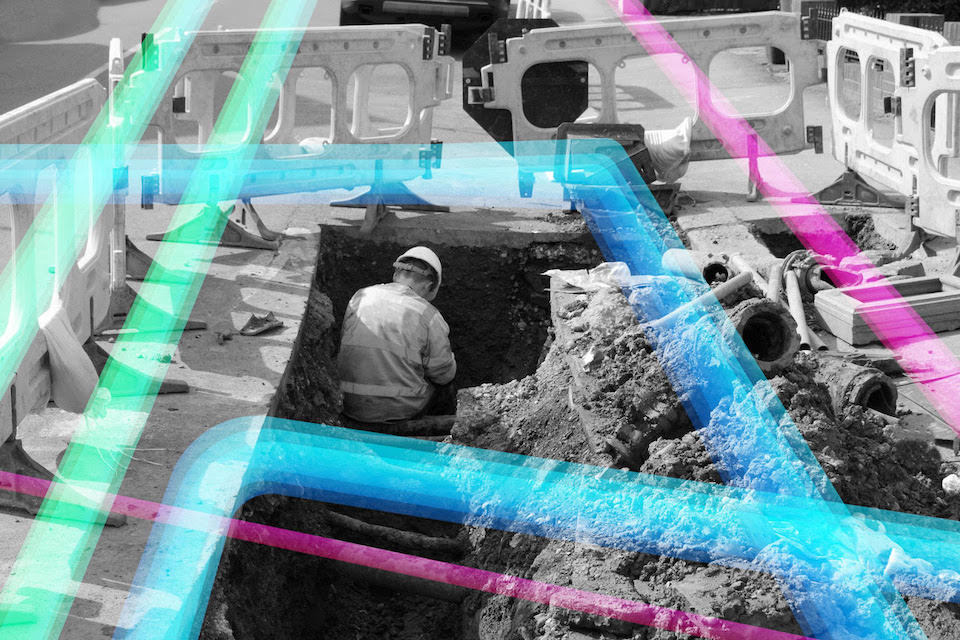
dug up road showing underground cables with person working on them
Data shared between asset owners and excavators must be free. However, this requires asset owners to continually respond to requests from numerous excavators, and excavators to contact multiple asset owners to source it, with data provided in different formats, scales and to varying timeframes.
Government-led programme
The National Underground Asset Register (NUAR) is a government-led programme aimed at streamlining the data-sharing process, reducing the number of potentially lethal utility asset strikes and promoting more efficient management and maintenance of underground assets. It is being developed as a single, secure data-sharing service for the location and characteristics of underground assets that will provide workers with an interactive, standardised digital view of the underground assets in a given location.
In 2019-20, two pilots were carried out in North East England and London to test the feasibility of creating a national register. These pilots were built upon two industry-led proofs of concept: (1) the Highways Asset Data Exchange System (HADES), led by Thames Water, which tested bringing together utility data at two sites in London into a single platform, and (2) the North East Underground Infrastructure Hub (NEUIHub), an initiative developed through Northumbrian Water Group’s Innovation Festival.
Through these pilots, it was determined that technology is not a barrier - there are a number of organisations which have the skills and expertise required to develop the technical solution. However, if creation of a register was to be successful, legitimate concerns raised by owners of underground assets related to security, commercial sensitivities, liabilities and safety needed to be addressed.
Delivering NUAR
Following the pilots, a subsequent phase of work commenced to bring together owners of underground assets, legal teams, future users, the Centre for the Protection of National Infrastructure and the National Cyber Security Centre, technical experts and other stakeholders across various sectors to address these challenges. Working in collaboration, a new legal framework was created for data sharing and identified and refined important technical requirements to ensure data shared through the platform is safeguarded and protected against misuse. A Data Model Governance Group was set up to establish the NUAR data model and transform asset owner data from all of the pilot participants to test it. Further research was also carried out to update the economic case and to understand how NUAR will work alongside other safe digging practices once in place.
Having addressed the challenges identified through the pilots, a competitive invitation to tender was launched in late spring 2021. Through this exercise, Atkins was appointed to lead the delivery of the new service. Atkins and their supply chain (Ordnance Survey, 1Spatial and GeoPlace), together with other partners (Greater London Authority and Welsh Government) commenced work in September 2021. The NUAR programme is now celebrating one year since work commenced on development of the service.
What we have done
Over the past year, we have been working hard to develop the new platform which will enable improved digital data sharing between asset owners and those who plan and carry out excavations. Once complete, the new platform will allow excavators to view digitised underground asset information across England, Wales and Northern Ireland, in one place, for the first time. This means, together with the VAULT system in Scotland, all areas of the UK will be covered by a standardised digital service for sharing and accessing subsurface utility data.
Engagement
In the transition from pilot to a production service, we have held security workshops to share and refine requirements, ensuring security mindedness remains at the centre of what we do. We have engaged with other international underground asset initiatives to learn and share best practice. Using project findings, we helped feed into the development of the new Model for Underground Data Definition and Integration (MUDDI model)[footnote 4], which will standardise the way geospatial data about underground infrastructure is presented. We have published the NUAR economic case and have given regular updates on our progress. Additionally, we have attended conferences, held webinars and hosted round tables to discuss in detail the benefits the service will bring to the underground asset industry.
We have also been liaising with asset owners in the three regions that are to go live first in 2023: North East England, Wales and London. In these regions, the NUAR onboarding leads have set up community user groups which are made up of asset owners who are located and/or have assets within the regions. These user groups have helped the onboarding of asset owners and have been instrumental in building the NUAR community by creating a channel where asset owners can exchange ideas, learn about the project’s vision and benefits, and most importantly provide input.
Legal frameworks
The user groups are also used to share progress reports, present platform features and elicit feedback at all stages of development. Over 500 stakeholders have been engaged in total to date. All feedback has been considered and, where appropriate, incorporated into the planned future development of the platform to ensure user needs are met.
The user groups have held crucial discussions on the two-part legal framework that governs data sharing within the platform. The two-part agreement begins with asset owners signing up to a Data Exploration Agreement (DEA) which allows the NUAR team’s data experts to map an asset owner’s data to the NUAR data model and provide feedback. Through this process a Data Ingestion Specification (DIS) is created which sets out how data will be provided and transformed on an ongoing basis. The second part involves asset owners entering into a Data Distribution Agreement (DDA) with the Cabinet Office which sets out the terms under which their data will be shared with others.
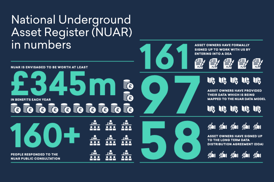
We have engaged with over 250 asset owners in the initial rollout regions, as well as some asset owners who operate in other regions. To date 161 asset owners have formally signed up to work with us by entering into a DEA. We have been provided data by 97 asset owners which the NUAR data team have mapped / are currently mapping to the NUAR data model. We have agreed DISs with 49 of the organisations who have shared their data with us. We also have 58 asset owners signed up to the long term DDA which allows their data to be shared with others via NUAR. DDAs have been assigned with asset owners of various sizes from all target sections, including all major utility providers in North East England and the majority of those in London[footnote 5].
Platform development
Work to develop the platform itself is also moving at pace. Working with our users, we have developed features including:
- Secure login using 2 factor authentication
- Navigating the map and seeing the contextual information about above-ground features
- Searching for an area using a street name, Unique Property Reference Number (UPRN), Unique Street Reference Number (USRN) or postcode
- Specifying an Area of Interest (AOI) and then editing it, using either either a circle or polygon
- Displaying and querying asset data
- Sharing locations with other users
The emerging platform has recently been assessed against the Government Service Standard [footnote 6], and met the required criteria which allows the platform to move to ‘private beta’. This means the team are now able to bring in real users, allowing feedback to be given and enhancements to be made.
Future model
Work is also underway to set out the platform’s long-term operating model. To inform this model, a public consultation ran from 7 April to 2 June 2022. The consultation sought views on areas including the potential need for supporting legislation to ensure end users have access to all the data they need and the future funding mechanism. The consultation had an excellent response, with over 160 replies. Consultation responses have been analysed and a government response will be provided shortly.
What others think
In our increasingly digitalised world, NUAR’s accessibility to visualised information which has been aligned across multiple sectors’ data is incredibly useful and powerful, enabling whole system collaboration for the benefit of customers and society as a whole.
Steven Gough,
DSO Technical Authority, Scottish and Southern Electricity Networks
When we find that assets are not in the place that we thought they were, the ability to push back information to the central repository and have this information available for everyone’s benefit, as opposed to it sitting in silos, is very exciting for industry.
Shelley Copsey,
Co-Founder & CEO, Fyld
This is really exciting from a local authority perspective - this concept is well overdue and it is great to see the progress.
Alex Cliff,
Highway Network and Digital Innovation Manager, Norfolk County Council
Our vision is to get a “single view of what is happening on the street”. NUAR will have a massive impact on planning of works.
David Capon,
CEO, Highways Authority Utility Committee (HAUC)
Economic case summary
Underground assets: the case for change
Every construction and infrastructure project must source information on buried utility assets, such as cables, pipes, sewers and ducts, when preparing ground investigation and excavation work. This data helps avoid costly damage to assets, and improves safety for workers and the general public by avoiding asset strikes.
The current process by which underground asset data is shared is fragmented. Multiple organisations are required to share their information and can provide data of varying quality: data may be incomplete, received in multiple formats and scales, on multiple base maps, with varying levels of accuracy. These inconsistencies make it challenging for all relevant underground asset data to be brought together in a standardised usable form, increasing the risk of accidents and resulting in projects taking longer, causing more disruption to the public, and costing more.
Benefits calculation approach
A national approach to digitalising underground asset data is estimated to create benefits of £3.4 billion over 10 years, or £30 worth of benefits for every £1 invested.
These benefits are made up of:
- Savings from reduced utility strikes, £240 million per year
- Reduced cost of sharing data, saving £91 million per year
- On-site efficiency improvements for projects, saving £16 million per year
Savings from reduced utility strikes
Utility strikes can lead to both direct costs (e.g. repairing damages) and indirect costs (e.g. project delays and extended road closures). Whilst there is some variation by sector the average direct cost per strike is £3,371. Indirect costs are estimated as, on average, 29 times larger than direct costs.
A widely reported industry statistic of 60,000 strikes per year on buried service pipes and cables was used as the basis of estimating the strike reduction benefits[footnote 7]. The central estimate of the proportion of strikes that could be avoided with better data is based on information from Industry Incident which reports that on average 30% of total incidents are linked to inadequate plans / on sight procedures. (Utility Strike Avoidance Group from 2014 - 2018)
Reduced costs of data sharing
We collected additional data to understand how a new model for data access could make efficiencies. A sample of 84 sector stakeholders, including asset owners, contractors and local authorities, identified the actions, time and cost to gather asset data and showed the steps in that process that would reduce cost. This found on average £91 million per year could be saved when scaled up across the sector.
On-site efficiencies
Projects can be delayed or abandoned because unexpected underground assets are found on site. This includes assets which are not on record or recorded incorrectly. Through user interviews, we found that per year 20,000 excavations are abandoned and 38,500 excavations face delays and resumption costs due to unexpected assets. The NUAR platform is expected to reduce these instances by providing a fuller picture of known underground assets whilst also improving orienteering on-site. It will also improve data accuracy over time through a function which allows workers to report inaccuracies.
Non-monetised benefits
There are also non-monetised benefits, such as more strategic improvements to street works coordination and subsurface planning, which are not currently quantifiable. Therefore, there is a very high level of overall confidence that the NUAR programme provides value for money, and this will be confirmed through a detailed evaluation plan.
What’s next
We credit our progress to date to the continued input, feedback and involvement of asset owners and other stakeholders who have worked jointly with us to develop the national register.
Our approach for the future is simple: we will continue to work with stakeholders to refine and enhance the service as it is rolled out across England, Wales and Northern Ireland. We will continue to get feedback and input from others, work across sectors and organisations, and use functioning software in the hands of workers as a measure of progress.
We will continue to prioritise providing a service that meets user needs. That is why we have taken an iterative and incremental approach to delivery, allowing us to share developments early, often and continuously, and seek feedback from users to improve it.
Minimum Viable Product
We will continue our work on the Minimum Viable Product (MVP), sharing new functionality and getting feedback regularly in our user groups. We will also enable limited access for testing purposes ahead of rolling the MVP out in North East England, Wales and London in 2023. The initial release will include data from across the different asset owner sectors for each region as well as core functionality, allowing the development team to get feedback from real users to further iterate the service. It will then be enhanced, both in terms of functionality and the data it contains, including starting to incorporate data from the remaining regions in England and Northern Ireland.
In parallel to working on our MVP, we will engage with asset owners operating outside the initial three regions, giving them an opportunity to feed into the development of the programme and to prepare for the live service in their area. We will also be conducting workshops and engagement meetings by sector, ensuring needs and requirements continue to be understood and met.
National Rollout
The Geospatial Commission is delighted to invite asset owners across Northern Ireland and all remaining parts of England to start their journey with NUAR.
If you have not already been invited to join our growing ecosystem of organisations sharing underground asset data please email nuaronboarding@cabinetoffice.gov.uk.
As part of the onboarding journey you will be able to learn more about NUAR, the legal framework, our approach to security and have personal sessions with our data experts to help you understand data requirements and to familiarise yourself with the platform.
Long-term operating model
We plan to refine options related to the long-term operating model for the service. Through our recently conducted public consultation, we received many helpful views and suggestions. Themes include the benefits and challenges of expanding the permitted use cases / user base, how and if the service should operate with the wider market, whether supportive legislation is needed to close any gaps in participation, and options for the long-term funding mechanism. We plan to formally respond to these submissions later this year on GOV.UK.
We recognise the various demands that are placed on owners of underground assets in relation to their data. We will continue to promote a joined up approach across initiatives, with the intention of minimising the frequency with which asset owners are required to share their data.
We have also recently established a new expert Advisory Group. This group, alongside our regional and sector user groups, as well as any other groups we form when needed, will continue to meet and to feed into our work.
We are looking forward to launching the NUAR MVP in 2023, and then enhancing the service while expanding its coverage nationally.
Timeline
Past (Sept 2021 onwards)
Sept 2021 - Work commences to develop the NUAR platform following the successful pilots.
Nov 2021 - NUAR economic case is published on GOV.UK.
Nov 2021 - Asset owners begin sharing data.
Feb 2022 - Asset owners begin signing up to the long-term data sharing agreement.
June 2022 - Public consultation completed seeking views on the future operating model, including legislation.
July 2022 - NUAR passes the government’s Alpha assessment, enabling the service to move to ‘private beta’. This means we can now start getting real users to test the service.
Sept 2022 - Second update report is published.
Future
Autumn 2022 - Limited access enabled for testing purposes.
Autumn 2022 - Consultation response is published on GOV.UK.
Autumn 2022 - Onboarding activities commence for asset owners in remaining regions in England and Northern Ireland.
2023 - Minimal Viable Product (MVP) goes live in North East England, Wales and London.
2023 - Work continues to enhance the platform in terms of both data and functionality.
FY 2024/25 - NUAR platform is operational.
-
Based on a collection of sources including Metje et al (2015) and National Grid ↩
-
Utility Strike Avoidance Group (2016) 2014 Utility Strike Damages Report ↩
-
UK Government (2021) National Underground Asset Register (NUAR) Economic Case Summary ↩
-
Open Geospatial Consortium MUDDI (Model for Underground Data Definition and Integration) Standards Working Group ↩
-
DEA, DIS and DDA figures correct as of 20 September 2022 ↩
-
UK Government (2022) Service Standard ↩
-
UK Government (2021) National Underground Asset Register (NUAR) Economic Case Summary ↩