MGN 324 (M+F) Amendment 2
Published 22 March 2022

© Crown copyright 2022
This publication is licensed under the terms of the Open Government Licence v3.0 except where otherwise stated. To view this licence, visit nationalarchives.gov.uk/doc/open-government-licence/version/3 or write to the Information Policy Team, The National Archives, Kew, London TW9 4DU, or email: psi@nationalarchives.gov.uk.
Where we have identified any third party copyright information you will need to obtain permission from the copyright holders concerned.
This publication is available at https://www.gov.uk/government/publications/mgn-324-mf-amendment-2-navigation-watchkeeping-safety-use-of-very-high-frequency-vhf-radio-and-automatic-identification-system-ais/mgn-324-mf-amendment-2
1. Introduction/background
1.1. The International Maritime Organization (IMO) and wider maritime community noted with concern the widespread misuse of VHF channels at sea, especially the distress, safety and calling Channels 16 (156.8 MHz) and 70 (156.525 MHz), and channels used for port operations, ship movement services and reporting systems. Although at sea VHF makes an important contribution to navigation safety, its misuse causes serious interference and, in itself, becomes a danger to safety at sea. IMO Member Governments have unanimously agreed to ensure that VHF channels are used appropriately and correctly.
1.2. It should be borne in mind that not all ships or marine craft carry or are required to carry AIS. The officer of the watch (OOW) should always be aware that other ships, in particular leisure craft, fishing vessels and warships, and some coastal shore stations, including Vessel Traffic Service (VTS) centres, might not be fitted with AIS.
1.3. The OOW should always be aware that AIS fitted on other vessels as a mandatory carriage requirement, might, under certain circumstances, be switched off on the master’s discretion and professional judgement. Users are, therefore, cautioned always to bear in mind that information provided by AIS may not be giving a complete or correct “picture” of shipping traffic in their vicinity.
2. VHF Communications and usage
2.1. All users of marine VHF on United Kingdom vessels and all other vessels in UK territorial waters and in vicinity of harbours are reminded in conformance with international and national legislation, that marine VHF equipment may only be used in accordance with the ITU Radio Regulations. These Regulations specifically prescribe that:
2.1.1. Channel 16 may only be used for distress, urgency and very brief safety communications, and for calling to establish other communications which should then be concluded on a suitable working channel;
2.1.2. Channel 70 may only be used for Digital Selective Calling, not oral communication;
2.1.3. On VHF channels allocated to port operations or ship movement services, such as VTS, the only messages permitted are restricted to those relating to operational handling, the movement and the safety of ships and to the safety of persons;
2.1.4. All transmissions must be preceded by an identification, for example the vessel’s name or call sign; and
2.1.5. The service of every VHF radio telephone station must be controlled by an operator holding a certificate issued or recognised by the station’s controlling Administration. This is usually the country of registration, if the vessel is registered. Provided that the Station is so controlled, other persons besides the holder of the certificate may use the equipment.
2.2. Channels 6, 8, 72 and 77 have been made available, in UK waters, for routine ship-to-ship communications, Masters, Skippers and Owners are urged to ensure that all ship-to-ship communications working in these waters is confined to these channels, selecting the channel most appropriate in the local conditions at the time.
2.3. Channel 13 is designated for use on a worldwide basis as a navigation safety communication channel, primarily for inter-ship navigation safety communications. It may also be used for the ship movement and port services.
2.4. IMO Resolution A.954(23), Proper use of VHF Channels at Sea, should be consulted. To get indicative information on typical VHF communication ranges, the section - “The Management of VHF” - within Admiralty List of Radio Signals Volume 5, published by the United Kingdom Hydrographic Office, may be referred.
3. Use of VHF to Aid Collision Avoidance
3.1. There have been a significant number of collisions where subsequent investigations have found that at some stage before impact, one or both parties were using VHF radio in an attempt to avoid collision. The use of VHF radio in these circumstances is not always helpful and may even prove to be dangerous.
3.2. At night, in restricted visibility or when there are more than two vessels in the vicinity, the need for positive identification is essential but this can rarely be guaranteed. Uncertainties can arise over the identification of vessels, correlation and interpretation of messages received. Even where positive identification has been achieved there is still the possibility of a misunderstanding due to language difficulties however fluent the parties concerned might be in the language being used. An imprecise or ambiguously expressed message could have serious consequences.
3.3. Valuable time can be wasted whilst mariners on vessels approaching each other try to make contact on VHF radio instead of complying with the COLREG. There is the further danger that even if contact and identification are achieved and no difficulties over the language of communication or message content arise, a course of action might still be chosen that does not comply with the COLREG. This may lead to the collision it was intended to prevent.
3.4. In 1995, the judge in a collision case said -“It is very probable that the use of VHF radio for conversation between these ships was a contributory cause of this collision, if only because it distracted the officers on watch from paying careful attention to their radar. I must repeat, in the hope that it will achieve some publicity, what I have said on previous occasions that any attempt to use VHF to agree the manner of passing is fraught with the danger of misunderstanding. Marine Superintendents would be well advised to prohibit such use of VHF radio and to instruct their officers to comply with the Collision Regulations.”
3.5. In a case published in 2002, one of two vessels, approaching each other in fog, used the VHF radio to call for a red to red (port to port) passing. The call was acknowledged by the other vessel but unfortunately, due to the command of English on the calling vessel, what the caller intended was a green to green (starboard to starboard) passing. The actions were not effectively monitored by either of the vessels and collision ensued.
3.6. Again, in a case published in 2006 one of two vessels, approaching one another involving a close quarter’s situation, agreed to a starboard to starboard passing arrangement with a person on board another, unidentified ship, but not the approaching vessel. Furthermore, the passing agreement required one of the vessels to make an alteration of course contrary to the requirements of the applicable Rule in the COLREG. Had the vessel agreed to a passing arrangement requiring her to manoeuvre in compliance with the COLREG, the ships would have passed clear, despite the misidentification of ships on the VHF radio. Unfortunately, by the time both vessels realised that the ships had turned towards each other the distance between them had further reduced to the extent that the last-minute avoiding action taken by both ships was unable to prevent a collision.
3.7. More recently, in 2014, inappropriate use of VHF radios was highlighted as a major factor in collision between a bulk carrier and container ship which occurred in open sea with very sparse traffic around the vessels. Navigating officers on both vessels relied solely on the VHF for collision avoidance decision to negotiate a manoeuvre that was contrary to the COLREG. To further complicate the matter, VHF radio communications were not conducted in English which was both of the ships’ working language, and which confused a relieving officer on one of the vessels who was not able to understand what had been tacitly agreed via the VHF communications.
3.8. Although the practice of using VHF radio as a collision avoidance aid may be resorted to on occasion, for example in pilotage waters, the risks described in this Guidance Note should be clearly understood and the COLREG complied with to their best possible extent.
4. Use of Automatic Identification System (AIS)
4.1. AIS operates primarily on two dedicated VHF channels (AIS1 – 161.975 MHz; and AIS2 – 162.025 MHz). Where these channels are not available regionally, the AIS is capable of automatically switching to alternate designated channels. AIS has now been installed on the majority of commercial vessels and has the potential to make a significant contribution to safety. However, the mariner should treat the AIS information with caution, noting the following important points.
4.2. Mariners on craft fitted with AIS should be aware that the AIS will be transmitting ownship data to other vessels and shore stations.
To this end they are advised to:
-
initiate action to correct any known improper installation;
-
ensure the correct information on the vessel’s identity, position, and movements (including voyage-specific) is transmitted; and
-
ensure that the AIS, if being off for any reason, is turned on, at least within 100 nautical miles of the coastline of the United Kingdom.
4.3. The simplest means of checking whether ownship is transmitting correct information on identity, position and movements is by contacting other vessels or shore stations. Increasingly, UK maritime rescue coordination centres and port authorities are being equipped as AIS base stations. As more base stations are established ashore, AIS may be used to provide a functional monitoring system in conjunction with Vessel Traffic Services and Ship Reporting (SOLAS Chapter V, Regulations 11 and 12 refer).
4.4. Many ship owners have opted for the least-cost AIS installation to meet the mandatory carriage requirement. By doing so many of the benefits offered by graphic display (especially AIS overlaid on radar) are not realised with the 3-line ‘Minimum Keyboard Display’ (MKD), although the unit may still be duly type approved.
4.5. It is becoming common practice for pilots to possess their own portable navigational equipment which they carry on board. Such devices can be connected to shipborne AIS equipment and display the targets they receive. This, so called, Pilot Connector Socket and suitable power outlet should be located somewhere of practical use to a marine pilot who may carry compatible AIS equipment. This should be somewhere close to the wheelhouse main conning position. Less accessible locations in chart rooms, e.g. at the after end of the wheelhouse are not recommended.
4.6. The routine updating of data into the AIS, at the start of the voyage and whenever changes occur, should be covered in the navigating officer’s checklist and should consist of:
-
ship’s draught;
-
hazardous cargo, if any;
-
destination and ETA;
-
route plan (way points);
-
correct navigational status; and
-
short safety-related messages.
4.7. The quality and reliability of position data obtained from targets will vary depending on the accuracy of the transmitting vessel’s Electronic Position Fixing System (EPFS) receiver. It should be noted that older EPFS equipment (before 2003) may not produce Course Over Ground and Speed Over Ground (COG/SOG) data to the same accuracy as newer equipment.
4.8. IMO Resolution A.1106(29), Revised Guidelines for the Onboard Operational Use of shipborne Automatic Identification Systems (AIS), published December 2015, should be consulted for better understanding of the operational functions and limitations of the AIS.
Use of AIS to Support Safety of Navigation
4.9. Modern radar and ECDIS units (installed onboard on or after 1 July 2008) have provisions for AIS integration which is able to ‘overlay’ additional information on the radar and ECDIS displays. However, this also implies that there will be older AIS “stand alone” units without integration to other displays.
4.10. On the vessels with integrated AIS and radar, if the target data from AIS and radar tracking are both available, and if the target association criteria (for example position, motion) are fulfilled such that the AIS and radar information are considered as one physical target, the activated AIS target symbol and the alphanumeric AIS target data is automatically selected and displayed as priority. This should be treated with extreme caution and only used for enhancing situation awareness and not for collision avoidance decision-making. Such systems are also required to have the provision of selecting an alternative priority whereby the radar-tracked targets and their data, including CPA (closest point of approach) and tCPA (time to CPA), are duly displayed.
4.11. AIS will provide identification of targets together with the static and dynamic information listed in the IMO AIS Guidelines (A.1106(29)). Mariners should, however, use this information with caution noting the following important points:
4.11.1. Collision avoidance must be carried out in strict compliance with the COLREG. There is no provision in the COLREG for use of AIS information, therefore, decisions should be taken based primarily on systematic visual and/or radar observations. The availability and display of AIS data similar to one produced by systematic radar target tracking (e.g. automatic radar plotting or tracking aid (ARPA, ATA)) should not be given priority over the latter. AIS target data will only be based on the target vessels’ course and speed over ground whilst for COLREG compliance such data must be based on the vessels’ course and speed through the water.
4.11.2. However, the use of AIS should NOT be considered to replace the need for a visual lookout or use of “all available means” but must be used to supplement information obtained from systematic radar plotting. It is possible that if over reliance is placed on AIS information the OOW could be in breach of Rule 7(c) – “assumptions made on the basis of scanty information”. Not all ships will be fitted with AIS, particularly small craft and many fishing vessels. Other floating objects which may be conspicuous on the radar will not be displayed by AIS. AIS will, however, sometimes be able to detect targets which are in a radar shadow area.
4.11.3. The use of VHF to discuss actions to take between approaching ships is fraught with danger and still discouraged. MCA’s view is that identification of a target by AIS does not completely alleviate the danger. Decisions on collision avoidance should be made strictly according to the COLREG.
4.11.4. AIS positions are derived from the target’s EPFS receiver. This may not coincide exactly with the target as detected by radar.
4.11.5. Faulty data input to AIS could lead to incorrect or misleading information being displayed on other vessels. Mariners should remember that information derived from radar plots relies solely upon data measured by the ownship’s radar and provides an accurate measurement of the target’s relative course and speed, which is the most important factor in deciding upon action to avoid collision. Existing ships of less than 500GT (gross tonnage) which are not required to fit a gyro compass are unlikely to transmit heading information.
4.11.6. A recent development of AIS is the ability to provide synthetic AIS targets and virtual navigation marks as aids to navigation (AtoN), in addition to the physical AIS AtoNs, enabling coastal authorities to provide an AIS symbol on the display in any position. Mariners should bear in mind that this ability could lead to the appearance of “virtual” AIS targets and therefore take particular care when an AIS target is not complemented by a radar target. IMO guidance as in MSC.1/Circ.1473, Policy on Use of AIS Aids to Navigation, should be consulted.
5. Presentation of navigation-related symbols, terms and abbreviations
5.1. The IMO circular, issued in 2019, SN.1/Circ.243/Rev.2 ‘Guidelines for the presentation of navigation-related symbols, terms and abbreviations’, with a view to harmonising the requirements for the presentation of navigation-related information on the bridge. These guidelines sought to ensure that all navigational displays adopt a consistent human-machine interface philosophy and implementation. These requirements come into effect from 2024/25. Until then, SN.1/Circ.243/Rev.1 Guidelines for the presentation of navigation-related symbols, terms and abbreviations, issued in 2014, should be used as the prevailing reference.
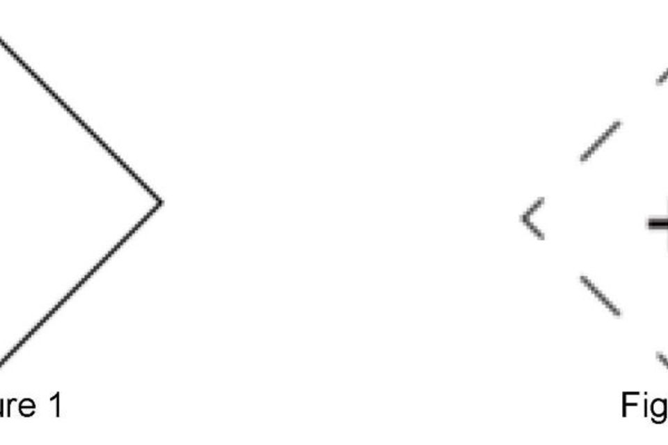
Physical AIS AtoN
Physical AIS AtoN is presented as an ‘open diamond’, as in Figure 1 below.
Virtual AIS AtoN
Virtual AIS AtoN is presented as an ‘open diamond with crosshair centred at reported position’, as in Figure 2 below:
More information
United Kingdom Technical Services Navigation
Maritime and Coastguard Agency
Bay 2/24
Spring Place
105 Commercial Road
Southampton
SO15 1EG
Telephone: +44 (0)203 8172 100
Email: navigationsafety@mcga.gov.uk
Website: www.gov.uk/mca
General enquiries: infoline@mcga.gov.uk