How we use drones at air accident sites
Published 7 June 2018

© Crown copyright 2018
This publication is licensed under the terms of the Open Government Licence v3.0 except where otherwise stated. To view this licence, visit nationalarchives.gov.uk/doc/open-government-licence/version/3 or write to the Information Policy Team, The National Archives, Kew, London TW9 4DU, or email: psi@nationalarchives.gov.uk.
Where we have identified any third party copyright information you will need to obtain permission from the copyright holders concerned.
This publication is available at https://www.gov.uk/government/publications/how-we-use-drones-at-air-accident-sites/how-we-use-drones-at-air-accident-sites
How we use drones at air accident sites
Aerial images are very useful for accident investigation. They can capture the whole site from the initial impact point to the wreckage’s final resting location. The ground marks and wreckage distribution help to identify how the aircraft hit the ground. They can show the relative positions of obstacles, such as trees or buildings, that may have been struck before ground impact. They help to reveal the surrounding terrain and environment that the pilot faced if there was an attempted forced landing. And when it’s a large aircraft at an accident site, aerial images help to document the damage to its upper surfaces.

Our first use of a drone at an accident site in 2014.
Drones provide an efficient alternative to police or search-and-rescue helicopters, which we sometimes relied on in the past to obtain aerial images. We first used a drone at an accident site in 2014 and the technology has improved markedly in just a few years. Our latest drone is capable of taking high quality stills and video in winds up to 20 kt, with the ability to take overlapping images to map the whole of an accident site. Other benefits of using drones are that they can be flown close to trees and wreckage to obtain close-up images without disturbing them with rotor downwash, they can be programmed to take a series of geo-tagged and overlapping overhead shots for photogrammetry purposes and they can operate in low-visibility and low-cloud conditions that would prevent an airplane or helicopter being flown.
More than pictures and videos
We use our drones for wreckage and site surveys, searching for wreckage, estimating the height of trees and other objects, conducting site safety assessments and reconstructing flight paths.

Drones for health and safety: supervising recovery of wreckage when a helicopter crashed in the sea below cliffs.
Specialist photogrammetry software allows us to create orthomosaic images and 3D models of accident sites. An orthomosaic is an image composed of multiple overhead images and is corrected for both perspective and scale, which means that it has the same lack of distortion as a map. The images are obtained by programming the drone to fly in a grid pattern and to automatically take a series of overlapping shots with the camera pointing 90 degrees down. This takes a matter of minutes, followed by a few hours’ PC processing.
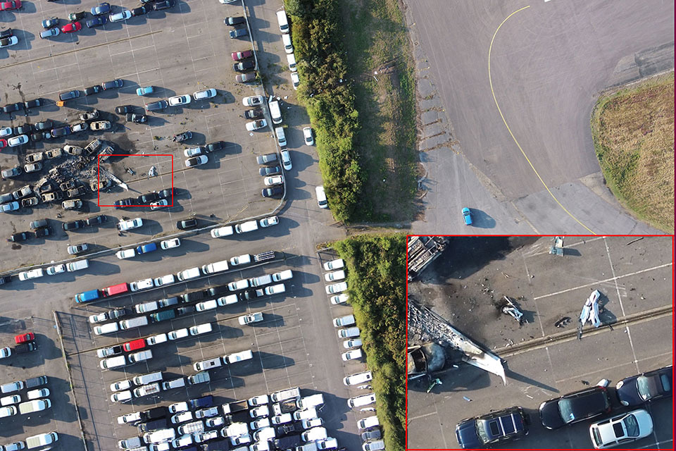
Orthomosaic generated from 59 overlapping images taken from a height of 50 metres (inset: digitally zoomed-in section).
The photogrammetry software also generates a 3D point cloud and a 3D mesh from the images. The 3D model can be used to take measurements of an accident site up to an accuracy of 1 cm, based on images captured from a height of 40 m. This is more accurate than measurements taken using a handheld GPS unit. These models are a useful tool for briefing team members who weren’t at the accident site, as by zooming in or out and rotating the model, they can visualise the site more easily than using stills images.
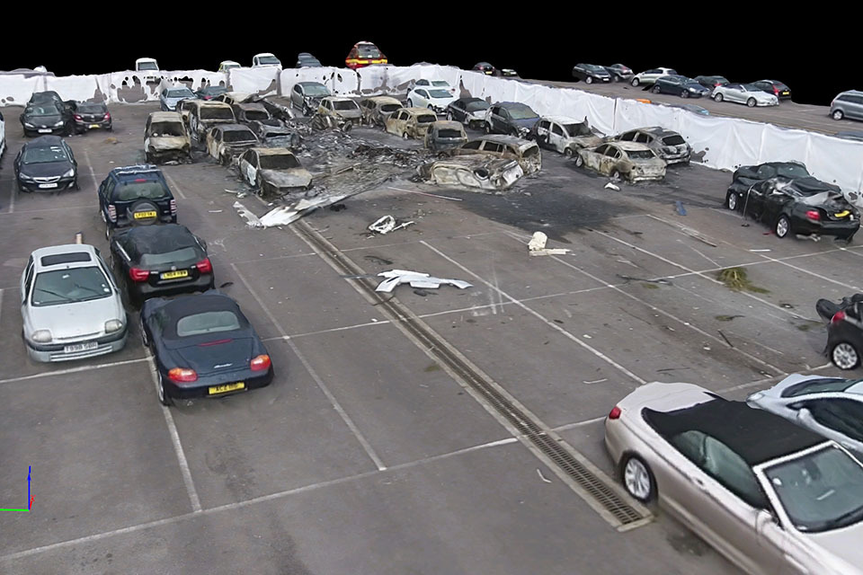
3D mesh created from oblique video, made by flying two circles at two different heights around the main wreckage.