Government Estate Nature Plan (accessible version)
Published 26 June 2026
Applies to England

© Crown copyright 2026
This publication is licensed under the terms of the Open Government Licence v3.0 except where otherwise stated. To view this licence, visit nationalarchives.gov.uk/doc/open-government-licence/version/3 or write to the Information Policy Team, The National Archives, Kew, London TW9 4DU, or email: psi@nationalarchives.gov.uk.
Where we have identified any third party copyright information you will need to obtain permission from the copyright holders concerned.
This publication is available at https://www.gov.uk/government/publications/government-estate-nature-plan-genp/government-estate-nature-plan-accessible-version
Foreword
As the largest landowner in England, the government has a unique responsibility, and a unique opportunity, to demonstrate how nature recovery can be delivered alongside essential public services. Across defence land, transport corridors, forests, farmland and urban estate, government owns and manages land that shapes the character and health of our landscapes and underpins our economy. How this land is managed matters for nature, for communities, and for the long-term resilience of the country.
Nature is declining at an unprecedented rate. At the same time climate impacts such as flooding, wildfire and water shortages are already affecting government land and the services it supports. Healthy ecosystems play a vital role in managing these risks. They reduce flood risk, improve water quality, store carbon, support pollination, and provide recreational spaces for cultural and health benefits that extend well beyond the boundaries of the government estate. Restoring nature is therefore not separate from the business of government, it is central to protecting public assets and sustaining the public value they provide.
Government departments are already taking action to protect and restore nature across their estates. However, environmental systems do not respect administrative boundaries. Acting site by site, or department by department, limits what can be achieved and slows progress at a time when we need greater pace and scale. The scale and urgency of nature’s decline demands a more joined up approach, one that connects landholdings, aligns effort and targets action where it can deliver the greatest benefit.
The Government Estate Nature Plan sets out how the government will meet that challenge. It establishes a new, practical approach to delivering nature recovery across the government estate, ensuring that nature recovery is embedded alongside operational delivery.
This plan is part of a wider shift across government towards more strategic and integrated land use decision making, in line with the government’s new Land Use Framework and the Environmental Improvement Plan. As one of the founding programmes of the Taskforce on Environmental Resilience and Efficiency (TERE), it brings departments together to manage shared environmental risks, strengthen operational resilience and remove barriers that prevent collective action.
As England’s largest landowner, government must lead by example. Through the Government Estate Nature Plan, we are committing to act collectively and at pace to restore nature across the land we own. In doing so, we will demonstrate how nature recovery can be delivered effectively, proportionately and at scale, strengthening the foundations on which economy, public services and communities depend.
Mary Creagh CBE MP
Executive summary
The Government Estate Nature Plan (GENP) establishes a new model for how the government will manage its estate to achieve better outcomes for nature. It moves from isolated activity to a practical and coordinated whole estate approach. This model better enables departments and public bodies to plan together, use shared data, access specialist capability, and overcome delivery barriers. In doing so, it supports nature recovery at scale and achieves outcomes that no single organisation can deliver alone.
All government land is held to deliver public value- from military training to timber production, energy infrastructure to transport corridors. The GENP enables nature recovery to be delivered more effectively alongside the operational priorities of the land, recognising the inherent value of healthy ecosystems in supporting the delivery of public services.
Government departments are already delivering significant and valuable action for nature across their estates, reflecting their different operational roles and local contexts. However, environmental challenges such as flooding, habitat fragmentation and water scarcity operate at a landscape scale and are not confined to individual sites or organisational boundaries. The GENP provides the means to address these shared challenges collectively, building on existing good practice to deliver greater impact.
The GENP will drive effective and coordinated delivery of nature recovery on government land by:
- investing in lighthouse projects to demonstrate how coordinated action on government land can deliver measurable benefits for nature, resilience and public value
- enabling landscape scale delivery by connecting government land and aligning action across departmental boundaries, and with other landowners
- establishing a comprehensive shared evidence base for government land, enabling holistic decision making and transparent reporting
- embedding cross government collaboration and consistent decision making as standard practice, moving from isolated action to collective delivery at pace
- identifying and addressing barriers to delivery, supporting departments to embed nature consistently in estate planning and investment
- building the case for future investment in nature recovery, through proportionate monitoring, evaluation and evidence of value for money
A central feature of the GENP is a programme of lighthouse projects- strategically selected pilot projects on government land that will demonstrate how coordinated action can deliver tangible outcomes for nature and support the operational purpose for which the land is held. Outcomes from these projects will be used to inform future delivery models and build the case for scaling up nature recovery across the government estate.
As England’s largest landowner, government has a clear responsibility to lead on nature recovery. Led by Defra, the GENP sets the framework for coordinated action across departments, demonstrating how nature recovery can be embedded alongside operational priorities to deliver resilience and public value across the government estate.
Vision
Purpose
The purpose of the GENP is to improve outcomes for nature across government land by addressing nature recovery as a shared, system-wide land use challenge.
Our vision
By 2042, aligned with England’s statutory biodiversity targets, the government estate plays a leading role in halting and reversing biodiversity decline. Nature recovery is fully integrated with core operational functions, contributing to a resilient and well connected network of habitats that supports species recovery and delivers lasting benefits for society and the economy.
How we will get there
To deliver this vision, the government will enable change through the following levers:
- targeted investment: Initial investment of £4.1 million to test new collaborative approaches to nature recovery on government land, and to build the evidence to support further investment
- cross government collaboration: Making estate-wide planning, delivery and problem solving the default through a coordinated approach to sharing resources, capability and knowledge
- better data and evidence: Building a shared understanding of government land so decisions on land use, investment and trade offs are informed, consistent and transparent
- embedding nature into decisions: Applying a natural capital approach and the principles of the Land Use Framework to estate management and investment choices
- in partnership beyond the estate: Working with National Estate for Nature members and other landowners to scale up action beyond the government estate and contribute to Local Nature Recovery Strategy (LNRS) priorities
Scope
The scope of the GENP defines the areas of government owned land on which departments will work collaboratively to deliver government’s vision for nature recovery and environmental improvement.
In scope:
- all government departments and all government land within England
- 24 ministerial departments and associated public bodies and agencies
- all terrestrial government land which is owned by the government or held on a lease for more than 7 years
Out of scope:
- the wider public estate owned or controlled by public authorities for the purpose of delivering public services (such local authority owned land, estate owned by NHS trusts in health, and the schools estate in education)
- government land outside of England (within the jurisdiction of devolved administrations or overseas territories)
- land held on a short lease (less than 7 years) or under other management agreement
The government estate
The government estate is the largest landholding in England. Analysis undertaken for the purpose of this plan (Methodology note: Mapping the government estate) estimates the total estate to be more than 560,000 hectares, or around 4% of England’s land area. It is managed by multiple departments to deliver essential public services, including national security, transport, energy, housing, food and timber production, and environmental protection.
Figure 1 shows the wide geographical spread of government land across England.
Supporting analysis is set out in the analytical annex.

Figure 1: Map of government land (Source: HMLR. The polygons (including the associated geometry, namely x, y co-ordinates) and UPRNs are subject to Crown and GeoPlace LLP copyright and database rights 2025 Ordnance Survey AC0000851063)
Figure 2 shows land ownership by government department. Defra group own over half of the government estate (312,715 hectares). The Ministry of Defence is the next largest land owning department with 158,701 hectares. Other large land owning departments are Department for Transport, Ministry of Housing, Communities and Local Government, Department for Energy Security and Net Zero and Ministry of Justice
Figure 2: Land ownership by department in England (terrestrial, above medium high water, hectares)
| Department | Hectares |
|---|---|
| Defra Group | 312,715 |
| Ministry of Defence | 158,701 |
| Department for Transport | 64,044 |
| Ministry of Housing, Communities and Local Government | 9,466 |
| Department for Energy Security and Net Zero | 2,877 |
| Ministry of Justice | 2,733 |
| Other | 1,589 |
‘Other’ includes departments which each hold smaller areas of land. These are:
-
Department for Culture, Media and Sport
-
Department of Health and Social Care
-
Department for Work and Pensions
-
HM Treasury
-
Home Office
-
Department for Education
-
Foreign, Commonwealth & Development Office
Land use on the government estate
Government land is held to deliver a wide range of essential public services. The diverse land uses include:
- defence land, managed by the Ministry of Defence, supporting military training, operations and national security. This includes large rural training areas as well as airfields, barracks and maritime sites
- land held for environmental purposes, predominantly owned by Defra and its public bodies, including Forestry England, the Environment Agency and Natural England. This land is managed for a variety of purposes including forestry, nature conservation, and flood and coastal risk management
- transport corridors, managed by bodies sponsored by the Department for Transport, including Network Rail and National Highways. These landholdings are predominantly linear, comprising railways, roads, verges and embankments
Figure 3: Upland blanket bog at Otterburn Training Area. (Source: Ministry of Defence)

Figure 4: Wild Neroche habitat restoration. (Source: Forestry England)

Figure 5: A21 Lamberhurst green bridge (Source: National Highways)
The imperative for change
This GENP is underpinned by 3 interlinked imperatives that frame the case for collective action on nature recovery across the government estate. These imperatives relate to the need to safeguard operational resilience, maximise the public value of natural assets, and support delivery of legal and policy requirements. Addressing them effectively requires coordination across departments and landscapes, rather than isolated action at individual sites.
Operational imperative
Nature recovery on the government estate is essential to the resilience and continuity of critical public services. Government land underpins defence, justice, health, transport and other essential functions, all of which depend on healthy, functioning ecosystems in good condition. For example:
-
peatlands regulate water flow and reduce downstream flood risk
-
woodlands stabilises slopes and improves air quality
-
wetlands buffer storm surges and purify water
As climate and environmental pressures intensify, degraded habitats increase exposure to flooding, wildfire and other risks, driving higher costs and threatening operational performance. Restoring these natural systems builds resilience into the physical infrastructure on which government operations depend.
Economic and social imperative
The government estate represents a significant opportunity to deliver wider social and economic value. The natural capital on government land generates public benefits through ecosystem services such as flood regulation, carbon storage, improved air and water quality, recreation and public health.
An economic assessment undertaken by Eftec (2025) indicates the government estate has capacity to generate ecosystem services valued at £67 billion (present value over 60 years) from natural capital maintained in good condition.
Because the estate is distributed across England and multiple environments, coordinated management allows these benefits to accrue beyond individual sites, supporting surrounding communities and regional economies. This value is maximised when land is managed as a connected network rather than as isolated assets.
Legal and policy imperative
Coordinated action across the government estate is necessary to support delivery of statutory and policy commitments on nature recovery. The statutory Environment Act targets and Biodiversity Duty, and implementation frameworks such as the Environmental Improvement Plan and Land Use Framework all require action to restore nature at scale across landscapes.
A whole estate approach enables government to contribute effectively and proportionately to national nature targets- spatially targeting action while balancing nature recovery alongside operational and wider land use priorities.
Case study 1: Outstrays Managed Realignment Scheme (Environment Agency)
The Outstrays Managed Realignment Scheme has created 250 hectares of new habitat on the Humber Estuary, enabling vital coastal wetlands to flourish. The project will see the development of 175 hectares of intertidal mudflats and saltmarsh and 75 hectares of freshwater grassland, replacing habitat lost as a result of flood and coastal risk management. This large scale restoration boosts biodiversity, supports migratory birds and increases carbon storage.
Delivered through a partnership between the Environment Agency, Associated British Ports and JBA Bentley, the scheme demonstrates how coastal engineering can work with nature. The scheme strengthens tidal defences for over 100,000 people and critical infrastructure, supporting regional resilience, whilst delivering significant environmental gains. New paths and bird hides also improve public access, allowing communities to enjoy and engage with this landmark project.
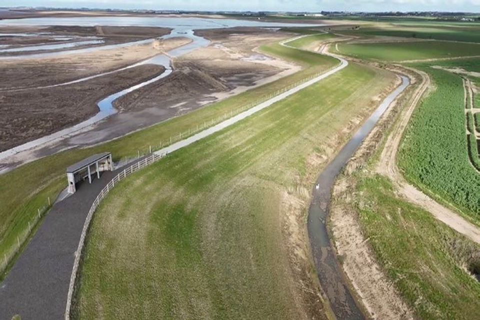
Figure 6: Outstrays Management Realignment Scheme. (Source: Environment Agency)
The new model for nature recovery on the government estate
Defra holds policy responsibility for nature recovery in England, but all government departments depend on a healthy natural environment to deliver their core operational functions. Environmental condition underpins operational resilience, risk management and long-term value for money.
The GENP therefore introduces a new, practical way of delivering nature recovery that recognises and harnesses this interdependency. It moves nature restoration away from fragmented, site by site activity towards coordinated delivery which is focused on outcomes that include operational resilience and value for money.
The GENP does not impose new duties on departments or represent a change in how land is owned and controlled within government. It is a new way of working that enables departments to deliver more impact from existing activity by coordinating action, targeting investment and removing barriers that cannot be addressed in isolation.
What the Government Estate Nature Plan will deliver
Between now and 2030, the government will:
-
invest £4.1 million in lighthouse projects on operational land to demonstrate how coordinated action can deliver measurable benefits for nature, resilience and public value
-
build a pipeline of nature restoration projects in priority locations, targeting contributions to national nature objectives where delivery can sit alongside core operational uses
-
create a single, shared evidence base for government land, including publication of the first digital map of the government estate, enabling whole estate planning and transparent decision making
-
remove practical barriers to delivery by identifying and addressing policy, regulatory and process constraints that currently slow or prevent action
-
make collaboration the default, embedding cross government working as standard practice rather than an exception
-
build the business case for scaling up investment, using evidence from lighthouse projects and wider implementation to inform future funding and expansion in later plan periods
Defra’s role
Defra’s role is to ensure the GENP operates as a coherent, whole‑estate approach. We will do this by connecting activity across the estate, accelerating delivery, and sustaining progress through the removal of barriers and the normalisation of collaboration.
Defra will:
-
provide the shared evidence base for government land, ensuring departments have access to consistent, high‑quality spatial and ecological data to support prioritisation, land‑use decisions and transparent reporting
-
operate the GENP framework, including governance arrangements, so departments can plan, prioritise and resolve delivery issues jointly
-
consistently apply Land Use Framework principles across the government estate, helping departments balance nature recovery with operational and economic requirements
-
identify, escalate and resolve systemic barriers to delivery, including policy, regulatory and procedural constraints that cannot be addressed through isolated departmental action
-
provide access to shared technical expertise and best practice, reducing duplication and supporting efficient delivery
-
lead the design and prioritisation of lighthouse projects, working with departments to identify priority locations, shape delivery models, align with operational needs and capture learning
-
oversee progress and value for money, using proportionate monitoring and evaluation to inform accountability and future investment decisions
How government departments will deliver the plan
Delivery of the GENP is a shared responsibility across government. All landholding departments and relevant public bodies are responsible for managing their land in ways that contribute to the plan’s objectives. Departments remain accountable for decisions and outcomes on their own estates, while working collectively through the GENP to deliver outcomes that cannot be achieved through isolated action. Collaboration across government enables departments to align effort, share expertise and maximise the public value delivered by government land.
In delivering the GENP, government departments will:
- apply the principles of the Land Use Framework when making decisions about land use, estate management and investment on the government estate, balancing nature recovery with operational and economic requirements
- maintain estate‑wide nature recovery plans aligned with GENP priorities and the operational context of their landholdings
- accurately register their land, keeping HM Land Registry records up to date so the government estate map remains reliable and current
- provide proportionate, agreed information on outcomes delivered through their estate, enabling Defra to aggregate and report on contributions to Environmental Improvement Plan targets while avoiding duplicative reporting
- align delivery with Local Nature Recovery Strategies, supporting coherent, place‑based action alongside other landowners and partners
- participate in cross government coordination and joint delivery, contributing expertise and capability where collective action is required
- embed nature recovery systematically into estate planning, investment and operational decision‑making, ensuring it is consistently considered as part of routine management of land
Case Study 2: Cockrow Green Bridge (National Highways)
Green bridges use vegetated decks to reconnect habitats fragmented by roads and other linear infrastructure. Completed in March 2026, the 30 metre wide Cockrow green bridge crosses the A3 in Surrey, linking 2 sections of the internationally designated Thames Basin Heaths, Ockham and Wisley Commons, previously divided by the road. The bridge forms part of a 3.8km corridor of restored lowland heath, enabling heathland specialist species and other wildlife to move safely, expand their range, and strengthen populations, increasing the site’s ecological resilience.
As a key element of the M25 Junction 10 improvement project, the bridge, combined with extensive heathland restoration on both sides of the network, has delivered significant biodiversity gains alongside major transport upgrades. It also incorporates active travel routes, improving public access to the surrounding landscape.
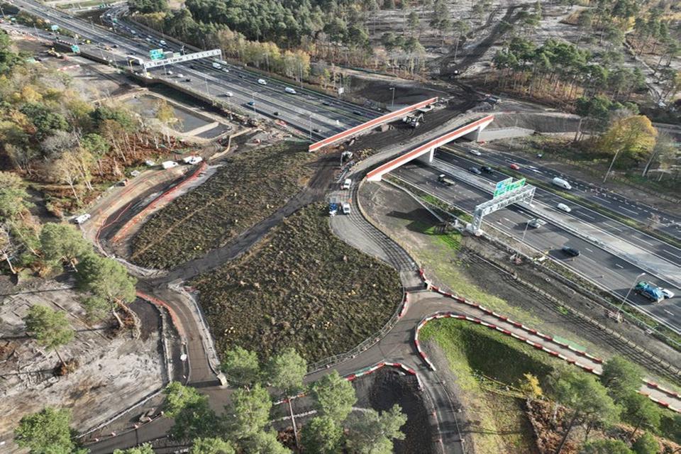
Figure 7: Cockrow Green Bridge (Source: National Highways)
Delivery priorities and milestones
The changes set out above, and the respective roles of Defra and government departments, will be taken forward through a staged delivery programme. Over the next 3 years, the GENP will move from coordination and early investment towards a mature, scalable approach to nature recovery on government land.
Delivery is structured around four priorities, which together set out how action will be taken forward in practice during this period- from early investment and delivery, to building the evidence, policy conditions and capability needed to scale ambition in future plan periods.
Delivery priority 1: Targeted investment in lighthouse projects to build a nature recovery pipeline
The primary mechanism for delivery under the GENP is the delivery of early phase nature recovery projects on government land. Between 2027 and 2030, government will invest £4.1 million in strategically selected lighthouse projects that demonstrate how coordinated, cross government action can deliver measurable benefits for nature, operational resilience and public value.
These lighthouse projects will form the leading edge of a wider delivery pipeline. They are designed to do more than deliver localised outcomes- they will establish repeatable delivery models that can be applied across the government estate, test delivery under real operational conditions, and generate robust evidence on costs, benefits, delivery risks and value for money. Each project will be monitored and benefits evaluated, including its contribution to national nature objectives and statutory targets.
Project selection will prioritise locations where coordinated action across departments can unlock shared benefits, including improved ecological connectivity, reduced environmental risk to public assets, and opportunities to align delivery with Local Nature Recovery Strategies and other landscape‑scale activity. Projects will be selected for their scalability, deliverability within operational constraints, and their potential to be expanded or replicated as part of a future pipeline of investment.
Actions:
- invest £4.1 million in a portfolio of cross government lighthouse projects, selected for their scalability, repeatability and potential to deliver multiple benefits
- design and deliver projects that enhance ecological connectivity and function at a landscape scale, while working within the constraints of operational land
- test innovative delivery models and partnership approaches through a learning by doing approach
- embed proportionate monitoring and evaluation to assess outcomes (including contribution to national nature targets), costs and value for money
- capture and apply learning from lighthouse projects to inform future delivery models, policy development and investment decisions
Delivery priority 2: Strengthening the case for scaling up investment
A core purpose of the GENP delivery programme is to build a credible and proportionate business case for scaling up nature recovery on government land, and prioritising locations for investment, within the context of the operational estate. This includes the publication and ongoing maintenance of a digital map of the government estate, forming a shared spatial foundation for prioritisation, planning and reporting across government, and externally with other landowners.
Evidence generated through project delivery will inform assessments of value for money, operational co‑benefits and long-term risk reduction. This will draw on natural capital approaches, to ensure environmental costs and benefits are systematically reflected in business cases, and will be supported by a shared, cross government evidence base.
This growing evidence base will support more informed prioritisation, enable transparent assessment of where investment delivers the greatest public value, and provide a robust foundation for future investment decisions. This approach enables government to increase ambition over time while remaining targeted, affordable and fiscally responsible.
Actions:
- publish a digital map of government landholdings to support transparency, accountability and collaboration with other landowners
- develop a common spatial data platform for use across government to support integrated land use planning, shared access to data, and alignment of investment decisions across estate priorities
- use improved spatial data and analysis to identify where, and in what ways, government land has the greatest potential to contribute to national nature targets, taking account of operational constraints and applying the principles of the Land Use Framework
Delivery priority 3: Aligning policy and decision making to enable delivery at scale
In parallel with developing projects and evidence, government will review and update relevant policies, standards and operational frameworks to ensure they enable nature recovery to be considered consistently alongside operational and economic requirements.
This work focuses on identifying and addressing constraints that unintentionally limit delivery, slow progress or create inconsistency across departments. It includes improving alignment between land use decisions, estate management practices, procurement standards and investment appraisal processes, so that successful delivery models can be replicated efficiently across the government estate.
By embedding nature considerations systematically into routine decision making, rather than treating them as exceptional or discretionary, government will reduce delivery friction and create stable conditions for long-term implementation and scale up.
Actions:
- support and lead policy development, providing technical input, evidence, and coordination to shape and refine policies that deliver measurable improvements for nature across the government estate. These may include areas such as pesticide use, land acquisition and management, repurposing surplus land for nature recovery, sustainable grounds maintenance, pollinator support, renewable energy integration, and engagement with emerging nature markets
- map policy barriers systematically to identify where existing policy creates unintended constraints or missed opportunities
- convene policy leads from across government to co-design solutions that support both operational delivery and nature recovery
- provide policy navigation support to departments to interpret and implement obligations, and understand how these could apply to operational land
Delivery priority 4: Building cross government capability and readiness for scale
Throughout this delivery phase, Defra will coordinate cross government activity to support delivery, share learning and maintain oversight of progress and value for money. Departments will retain responsibility for delivery on their own land, while contributing to a collective body of evidence and experience through GENP coordination mechanisms.
Action:
- utilise the Government Estate for Nature (GEN) group to align departmental nature recovery efforts, identify collaboration opportunities, and avoid duplication
- develop comprehensive business case support materials and resources that enable government departments to build robust, compelling cases for investment in nature recovery
- map existing expertise and identify resource and knowledge gaps and inform the design of support arrangements
- enable knowledge sharing and capability building to ensure that common challenges are addressed once, capitalising on collective expertise and avoiding duplication
- support collective procurement and delivery through joint commissioning of services for land management and nature restoration on government land, reducing cost and improving outcomes
This staged approach allows government to move at pace while managing risk. By the end of this phase, the government will have a stronger project pipeline, clearer evidence on costs and benefits, shared delivery capability, and a policy environment that supports delivery at scale, providing a robust foundation for expanding nature recovery across the government estate in future plan periods.
Delivery milestones and readiness to scale
To meet the ambition set out in the National Estate for Nature Terms of Reference, the GENP is being implemented through a time bound delivery programme, with clear milestones to demonstrate progress and readiness to scale.
By April 2027, government will:
- have selected, costed and begun delivery of the first tranche of lighthouse projects, using the £4.1 million allocated as seed capital
- have established proportionate monitoring and evaluation arrangements for lighthouse projects, including assessment of outcomes, costs and value for money
- have published a digital map of the government estate, providing a shared spatial evidence base to support prioritisation, planning and reporting across government
- have identified priority policy and process barriers to delivery on government land, with agreed actions in place to address them
By the end of the 2027 to 2030 period, government will:
-
have a demonstrable pipeline of nature recovery projects on government land, supported by delivery evidence and established delivery models
-
have robust, cross government evidence on the costs, benefits and replicability of coordinated nature recovery on operational land
-
be in a strong position to scale ambition, including through future Spending Review bids, informed by delivery experience and value for money evidence
Progress against these milestones will be reported annually, in line with the National Estate for Nature Minimum Standard.
Case Study 3: Peatland restoration at Warcop Training Area (Ministry of Defence and Defra)
The Ministry of Defence is taking major steps to restore nature across its estate. Warcop Training Area in the North Pennines is one of the largest peatland sites on the Defence estate. The Ministry of Defence is undertaking significant restoration on Murton Fell, where historic drainage has left large areas of exposed, eroding peat.
Following detailed surveys by the North Pennines National Landscape partnership, the Defence Infrastructure Organisation invested in the restoration of almost 50 hectares in winter 2025 to 2026.
The project included installing over 130 stone dams, nearly 400 coir rolls and additional timber structures to slow water flow, trap sediment and re-wet degraded blanket bog.
This nature based approach will improve SSSI condition, reduce CO₂ emissions, enhance water quality, lower downstream flood risk and cut wildfire risk, helping the landscape recover and adapt to climate change while maintaining essential military training capability.
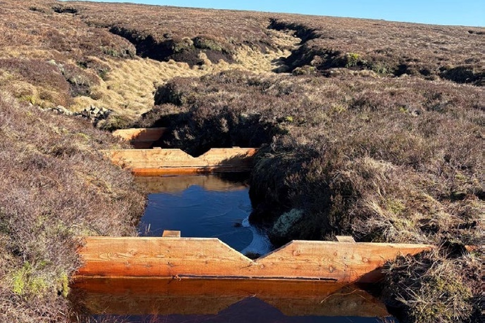
Figure 8: Warcop Training Area (Source: Ministry of Defence)
Governance
Delivery of the GENP is a shared responsibility across government. While Defra provides leadership, capability and oversight, all landholding departments and relevant public bodies are accountable for contributing to the achievement of GENP objectives on their estate.
Governance arrangements for the GENP are designed to ensure that:
- departments apply the Land Use Framework principles consistently in land use and estate decisions
- delivery is planned and prioritised through cross government mechanisms, rather than in isolation
- barriers to delivery are identified, escalated and addressed collectively
- progress against GENP objectives is monitored transparently and reviewed at a cross government level
Departments are required to engage through GENP governance structures as the primary route for collaboration, challenge and joint decision making where collective action is necessary to deliver outcomes.
Dual governance model
The GENP operates through a dual governance model, reflecting its position at the intersection of policy and operational delivery. Strategic oversight and challenge are provided by the Cross-Government EIP (Environmental Improvement Plan) Board and government property leaders, which together set direction, provide assurance and hold delivery to account.
The GENP operates within the Taskforce on Environmental Resilience and Efficiency (TERE), which provides cross government oversight, coordination and escalation where required.
Government Estate for Nature (GEN)
The Government Estate for Nature (GEN) is the central cross government mechanism for coordinating nature recovery across the government estate. The group brings together all major landholding departments and public bodies and is the primary mechanism through which the GENP is shaped, prioritised and delivered in practice.
GEN plays a critical role in translating GENP objectives into coordinated action. It aligns departmental priorities, enables joint working on shared challenges, and provides a consistent route for collaboration where outcomes cannot be achieved through departmental action alone. Through GEN, departments contribute expertise, evidence and operational insight, ensuring nature recovery is planned and delivered as a coherent, whole estate programme rather than a series of isolated initiatives.
Working with others: The role of the National Estate for Nature
No single organisation, however large its estate, can deliver landscape-scale nature recovery alone. Effective action requires coordination across catchments, landscapes and ownership boundaries.
The National Estate for Nature provides an important external forum through which the GENP is strengthened and challenged. It brings together major public, private and third sector landowners who collectively manage a significant proportion of England’s land and share a commitment to nature recovery.
Through the National Estate for Nature, the GENP benefits from peer review, constructive challenge and shared learning, helping to test assumptions, improve delivery approaches and align action with wider landscape scale initiatives. The network also creates opportunities for collaboration beyond the government estate, enabling government land to connect with complementary sites under other ownership.
This approach supports the creation of functional ecological networks, linking government land with neighbouring estates to form connected corridors and landscape scale infrastructure for nature.
Monitoring and evaluation
Purpose and approach
Monitoring and evaluation are designed to be proportionate, practical and focused on learning and accountability. It will assess whether the GENP delivery model is improving effectiveness across government, capture evidence from lighthouse projects to build the case for future investment, and support transparent, joined‑up reporting on how government land contributes to existing legal and policy commitments.
The GENP coordinates and aggregates existing reporting to improve efficiency, coherence and transparency across the government estate.
Monitoring the GENP delivery model
GENP monitoring will focus on whether the operating model is functioning as intended and adding value in practice. This includes assessing:
-
coordination and governance effectiveness: whether cross government coordination is enabling departments to plan, prioritise and deliver together more effectively
-
use of shared capability and data: the extent to which departments are accessing and using shared evidence, tools and technical support provided through GENP
-
reduction in duplication and delivery risk: whether joined‑up approaches are simplifying delivery, reducing duplicated effort and avoiding delays
-
policy coherence: progress in identifying and resolving policy, regulatory or procedural barriers that constrain delivery across the estate
Monitoring will draw primarily on programme data, qualitative feedback from departments and periodic, real time review through GENP governance structures.
Evaluating lighthouse projects and capturing value
Lighthouse projects are the primary mechanism through which GENP tests new approaches, demonstrates what coordinated action can achieve and generates evidence of value generated. Ecological monitoring to assess the outcomes of individual nature recovery interventions will be undertaken at the project level, in line with each project’s scope and requirements.
Each lighthouse project will include proportionate monitoring and evaluation appropriate to its scale and objectives. This will assess:
-
delivery and outcomes: whether projects achieve their intended ecological and operational outcomes within agreed timescales and budgets
-
contribution to national nature targets: the quantitative and qualitative contribution of lighthouse projects to national targets
-
multiple benefits: the extent to which projects deliver benefits for nature, operational resilience and wider public value
-
costs and value for money: including, where appropriate, comparison with alternative delivery approaches
-
replicability and scalability: what elements of the project can be applied elsewhere across the government estate
Learning from lighthouse projects will be captured systematically and fed back into GENP governance, policy development and future investment decisions. This evidence base is a core GENP output and underpins the case for scaling up nature recovery on government land in future plan periods.
Reporting on progress and contributions to national commitments
The current reporting landscape is fragmented, with multiple overlapping requirements and limited visibility of the collective contribution of the government estate. The GENP addresses this gap by providing a coordinated approach to reporting and aggregation, while maintaining departmental accountability for delivery.
GENP will:
-
centrally report annually on progress, in line with requirements under the National Estate for Nature Minimum Standard
-
enable departments to report once, using shared data standards and mechanisms where possible, to streamline multiple reporting needs
-
aggregate information across the estate to provide a clearer picture of the overall contribution of government land to national nature outcomes
-
support use of project level data, including from lighthouse projects, within existing reporting frameworks where this demonstrably contributes to national targets
Review and refresh
The GENP will be reviewed and refreshed on a regular cycle, informed by evaluation findings, delivery experience and changes in policy, evidence and funding context. This will ensure future plan periods build on what has been tested and learned, allowing objectives and delivery approaches to evolve as capability, confidence and coordination increase.
Case Study 4: His Majesty’s Prison and Probation Service Tree Nurseries
His Majesty’s Prison and Probation Service (HMPPS) operates a series of innovative tree nurseries across multiple prisons, using horticulture to promote prisoner wellbeing, skills development, and rehabilitation. Initially established with funding from Defra, the nurseries now operate with funding from the Ministry of Justice. The programme began in 2021 and engages prisoners in 9 men’s and women’s prisons across England.
Participants take part in meaningful outdoor work, cultivating species such as wych elm at HMP North Sea Camp in Lincolnshire, and Sitka spruce at HMP Woodhill in Milton Keynes.
Across the 9 prisons, 100,000 trees per year have been grown, which are then procured for planting schemes by other government departments. The initiative demonstrates how nature-based work can foster personal growth, support rehabilitation outcomes and contribute to the national tree stock.
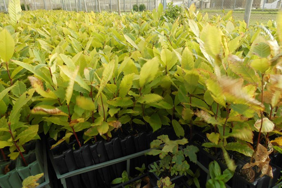
Figure 9: HMPPS Tree Nurseries (Source: Ministry of Justice)
Analytical annex
This annex provides an analytical overview of the government estate additional to the spatial context set out within section 2.
To further understanding of the natural assets within the estate, this annex integrates data from Defra’s flagship Natural Capital and Ecosystem Assessment (NCEA) programme.
The NCEA provides a baseline assessment of England’s land, freshwater, and coastal ecosystems, supporting a natural capital approach to policy and decision making. Additional habitat and spatial data from outside the NCEA programme are included where relevant.
The overlaps were calculated using ArcPro 3.4.0 tabulate intersection. Analysis was performed for departments and the whole estates. The parcels of land were dissolved by department and then by the whole estate to remove overlapping.
Broad Habitat Types
Figure 10 shows the relative proportions of broad habitat types across the government estate as modelled by the Living England 2022 to 2023 habitat prediction map and classified according to the UK Biodiversity Plan (UKBAP) (Natural England, 2024).
Coniferous woodland makes up the largest share at 22%, followed by broadleaved, mixed and yew woodland at 18%. Unimproved grassland accounts for 15%, while dwarf shrub heath represents 8% and bog represents 7%. Arable and horticultural land comprises 7% of the estate.
Figure 10: Habitat type across the government estate in hectares (Source: Living England 2022 to 2023 - General)
| Habitat | Hectares |
|---|---|
| Coniferous woodland | 121,578 |
| Broadleaved, mixed and yew woodland | 97,315 |
| Unimproved grassland | 83,190 |
| Dwarf shrub heath | 45,056 |
| Bog | 40,896 |
| Arable and horticultural | 40,889 |
| Built-up areas and gardens | 37,321 |
| Improved and semi-improved grassland | 23,890 |
| Fen, marsh and swamp | 15,917 |
| Bracken | 13,182 |
| Scrub | 12,533 |
| Bare ground | 5,674 |
| Water | 4,514 |
| Coastal saltmarsh | 4,304 |
| Coastal sand dunes | 1,752 |
| Bare sand | 1,403 |
| Solar farms | 97 |
Agricultural Land Use Classification
The new Predictive Agricultural Land Classification (ALC) replaces the outdated Provisional Agricultural Land Classification by incorporating more recent classification methodologies, including the distinction of Grades 3a and 3b land, and is based on best available data from the National Soil Map for England (NATMAP) and updated modelling.
The ALC System for England and Wales grades the quality of farmland for agricultural use. It provides a framework for classifying farmland from Grade 1: excellent quality, to Grade 5: poor quality.
Best and Most Versatile (BMV) land is land graded 1, 2 or 3a under the Agricultural Land Classification (ALC) system. ALC modelling shows that 24% of the government estate is classed as BMV land.
The remaining 76% is non-BMV land, which includes: - land graded 3b, 4 and 5 - urban and non-agricultural land, including buildings, roads, other infrastructure, forestry, parks, recreational grounds and water bodies outside ALC grading
Figure 11: Agricultural Land Classification across all of the government estate in hectares
(Source: Predictive Agricultural Land Classification (ALC))
| Category | Hectares |
|---|---|
| ALC 1 | 7,055 |
| ALC 2 | 37,665 |
| ALC 3a | 85,512 |
| ALC 3b | 60,098 |
| ALC 4 | 31,023 |
| ALC 5 | 90,033 |
| ALC Urban | 31,010 |
| ALC Non-agricultural | 205,418 |
Land within Environmental Land Management (ELM) schemes
The Sustainable Farming Incentive (SFI) pays farmers for practical actions that support food production while improving soils, water, wildlife, and overall farm resilience. Landscape Recovery projects unite farmers, landowners, environmental organisations and local communities to create and deliver tailored, large-scale, long-term plans that restore nature, enhance biodiversity, and create environmental benefits across whole landscapes.
The government estate was assessed for how much land they had within these 2 ELM schemes, as shown in Figure 12. Land within the SFI pilot and agreements made in 2022, 2023 and 2024 covered 12% of the total government estate (64,422 hectares), and 5% (28,253 hectares) participating in Landscape Recovery schemes which accepted applications for tranche 1 in 2022 and tranche 2 in 2023.
Figure 12: Land in ELM schemes across the government estate in hectares
(Source: Rural Payments Agency)
| Scheme | Hectares |
|---|---|
| Sustainable Farming incentive | 64,422 |
| Landscape Recovery | 28,253 |
Woodland coverage
Three datasets are used to understand the distribution of woodland and trees across the government estate. The National Forest Inventory (NFI) woodland map covers all forest and woodland area over 0.5 hectare with a minimum of 20% canopy cover, or the potential to achieve it, and a minimum width of 20m. This includes areas of new planting, clearfell, windblow and restock.
The Ancient Woodland Inventory describes the extent and location of ancient woodland; meaning land that has had a continuous woodland cover since at least 1600CE. Ancient woodlands are mapped to 0.25 hectares.
To understand tree distribution outside of NFI areas we use the National Trees Outside Woodland Map to identify canopy cover over 3m tall and 5m2, this includes small woodland, lone trees and hedgerows.
In total, 50% of government land, equivalent to 274,672 hectares have tree and woodland canopy cover.
This includes:
- 47% of land in the NFI
- 6% of the government estate is ancient woodland
- 3% of land is covered by canopy cover from trees outside the Woodlands map.
Urban land
The GENP uses the Living England ‘built up and gardens’ category as a proxy for ‘urban’. This category includes residential gardens, parks, recreation grounds and allotments.
7% (37,321 hectares) of all government land is classified as ‘urban’.
The ‘built up and gardens’ category was primarily mapped using areas within Ordnance Survey MasterMap (OSMM) identified as ‘ManMade’, supplemented by additional areas along urban fringes in the OS Open Built-Up Areas dataset. Land segments are classed as urban if they are overlapping any of these mapped areas. Because allotments were missing from OSMM, their locations were added using OpenStreetMap data.
Protected landscapes
National Parks and National Landscapes (formerly Areas of Outstanding Natural Beauty) are our most iconic and inspiring places, underpinning our health, economy and climate. This government has committed to make these protected landscapes greener, wilder, and more accessible to all.
36% (199,907 hectares) of the government estate is within Protected Landscapes, and Defra owns 75% of that land.
Protected Landscapes contain half of England’s priority habitats and Sites of Special Scientific Interest, including:
- 60% of deep peat
- around 88% of heather and acid grassland habitats
Deep peat
The England Peat Map is the most complete map of England’s peatlands and peaty soils to date. It models the extent, depth, and aspects of condition of our peat. Deep peat is defined as soil containing a peat layer at least 30cm thick, this provides major environmental benefits, including carbon storage, wildlife habitat and flood protection.
The England Peat Map shows that 25% of the government estate is deep peat and 82% of this land is owned by Defra.
Sites of Special Scientific Interest (SSSI)
SSSIs are designated under the Wildlife and Countryside Act (1981) to protect England’s most important habitats, species and natural features (Natural England, 2025).
30% of the government estate lies within an SSSI.
SSSI condition
SSSI units are divisions of SSSIs used to record management and condition details (Natural England). Natural England categorises the condition of sites of special scientific interest (SSSIs) units according to condition.
The split of condition of SSSI units within the government estate are split as follows:
- Favourable - 57,755 hectares
- Unfavourable recovering - 85,336 hectares
- Unfavourable no change - 9,262 hectares
- Unfavourable declining - 14,236 hectares
- Part destroyed - 196 hectares
- Destroyed - 16 hectares
- No condition data available - 779 hectares
Because SSSI condition is assessed at a unit level rather than at a whole-site level, a single SSSI may contain units with differing condition status. These overlaps in condition status mean the sum of areas classified by condition type is greater than the total area of SSSIs in the government estate.
30by30
The UK has committed to protect 30% of land and sea for nature by 2030. This supports the global 30by30 target agreed at the UN Biodiversity Summit (COP15). Our commitment to this international target is enshrined within the Environmental Improvement Plan.
The 30by30 commitment presents an important opportunity to demonstrate the UK’s international leadership on nature conservation. For land to contribute to the 30by30 commitment it must meet the 3 criteria:
- purpose
- protection
- management
This ensures that areas are effectively conserved and managed for nature.
About 37% (202,912 hectares) of the government estate in England is estimated to meet the 30by30 criteria.
Further analysis will confirm the potential for further contribution to the 30by30 target.
This estimate is based on the amount of category A data within the government estate, as set out within Methodology Note: A data led assessment of areas in England that count or have potential to count towards the 30by30 target.
Data use and limitations
To map the government estate, we have used a novel approach that relies on the use of HMLR data to improve our understanding of the spatial extent of the land held. This approach is not perfect and there are limitations with the produced data, including overlaps in the department estates which cannot be resolved when providing relative areas of department estates.
Not all of the identified government estate will be suitable for nature recovery interventions for several possible reasons, including:
- restrictions on land parcel uses
- inclusion of the built estate
- short leaseholds
- leasing of land to third parties
Departments may also manage or support management of land which is not part of their estate as recorded in HM Land Registry, including:
- Department for Education land ownership excludes the maintained schools estate. The schools estate is not owned by the Department for Education and is therefore outside of the scope of this plan. The maintained schools’ estate represents 51,420 hectares. The Department for Education encourages schools to participate in the National Education Nature Park
- Department for Health and Social Care land ownership excludes land owned by NHS trusts
- Natural England (Defra group) land ownership excludes National Nature Reserves which are owned by others but managed by Natural England under Natural Reserve Agreements
- Ministry of Defence land ownership excludes land where the department holds access rights
Overall, we have good confidence in the overall dataset through validation with government departments and comparison to published statistics and datasets. Comparison to figures published in the Government Estate: Annual Data Publication 2024 to 2025 found a 5% difference overall.
See the published methodology note for an outline of the method used to create the government estate dataset and a full list of data assumptions, quality considerations, limitations and caveats.